

Massachusetts, unlike many states, does not seem to publish GIS data for water quality classifications. However we finally “cracked the code” and have been able to create maps which show cold water habitat (see the Coldwater Fish Resource link in the MA Resources menu).
That’s not to say MA didn’t publish a lot of water quality information that is potentially useful to folks seeking wild trout. It does and some of it is useful as a supplement to the CFR maps.
Check out the map below and the list that follows. Massachusetts is divided into 27 major watersheds. We’ve labeled them “Cold” if they include at least SOME streams which the state regulations designate as “cold water”. Download the “State Regs” document and look up the watershed you’re interested in.
We’ve also provided the latest “Watershed Water Quality Assessment Report” (WWQAR) for each of the watersheds marked “Cold” in the list. These provide a treasure trove of qualitiative information. Check out the “USE ASSESSMENT – AQUATIC LIFE USE” sections for relevant stream segments. They’ll give typically give you results from fish sampling done in the area.
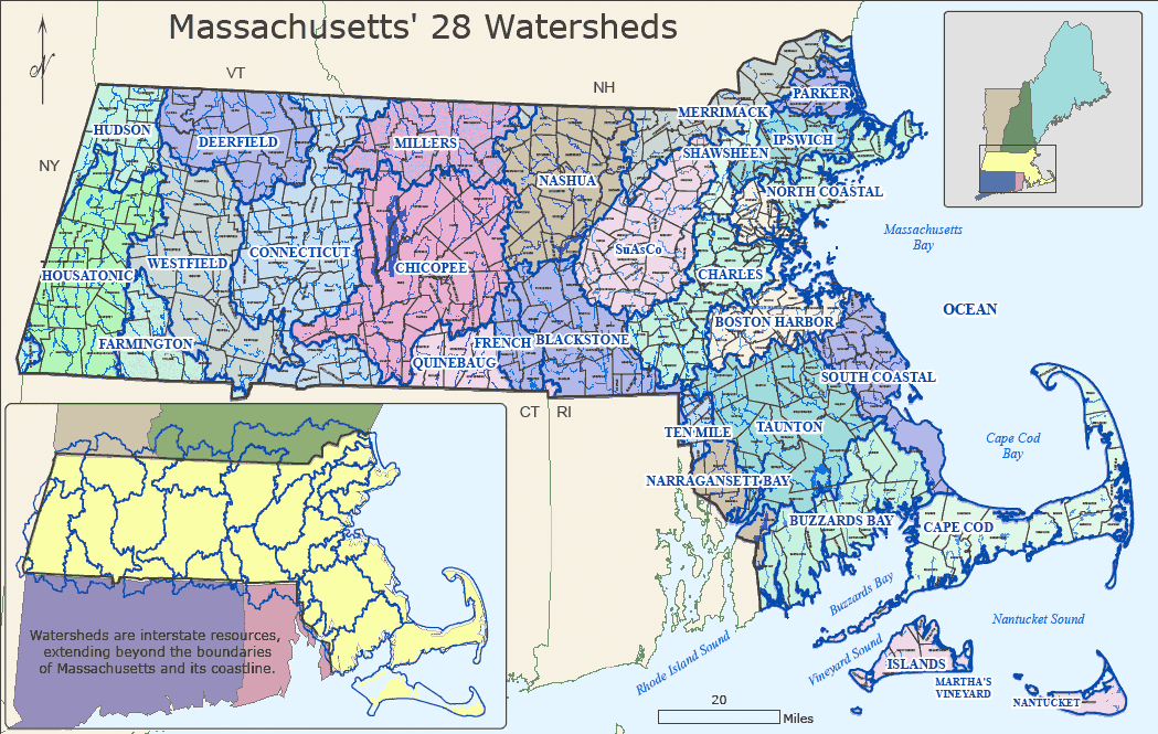
1 Hudson River Basin – Cold
2 Housatonic River Basin – Cold
3 Farmington River Basin – Cold
4 Westfield River Basin – Cold
5 Deerfield River Basin – Cold
6 Connecticut River Basin – Cold
7 Millers River Basin – Cold
8 Chicopee River Basin – Cold
9 Quinebaug River Basin – Cold
10 French River Basin – Warm
11 Blackstone River Basin – Cold
12 Ten Mile River Basin – Warm
13 Narragansett Bay/Mount Hope Bay Drainage Area – Cold
14 Taunton River Basin – Warm
15 Boston Harbor Drainage Area – Warm
16 Charles River Basin – Warm
17 Nashua River Basin – Cold
18 SuAsCo River Basin – Cold
19 Shawsheen River Basin – Warm
20 Merrimack River Basin – Cold
21 Parker River Basin – Warm
22 Ipswich River Basin – Warm
23 North Coastal Drainage Area – Warm
24 South Coastal Drainage Area – Warm
25 Buzzards Bay Coastal Drainage Area – Warm
26 Cape Cod Coastal Drainage Area – Warm
27 Islands Coastal Drainage Area – Warm
* The tables don’t generally list “designated use” stream by stream. Instead, they list the largest stream in a given region which is cold water habitat, and then assert that the higher order tributaries are included unless listed as an exception. So if you’re looking at a headwaters stream, in general you’ll need to figure how it flows into the major streams within the basin.
13,583 Responses
custom printed notebook journals
This web site was… how do you say it? Relevant!! Finally I’ve found a thing that helped
me to. Cheers!
my web site; custom printed notebook journals
Valentin Lewerke
I simply want to mention I am just beginner to blogs and absolutely liked you’re web-site. More than likely I’m going to bookmark your blog . You certainly have perfect article content. Thanks a bunch for revealing your website.
notebook wallet field notes
Hey There. I came across your weblog the usage of msn. This really is a very neatly
written article. I will make certain to bookmark it and return to learn more of your
own helpful information. Thanks a lot for that post.
I will certainly return.
Also visit my site – notebook wallet field notes
traveler's notebook passport bullet journal
Hi there colleagues, how is the whole thing, and what you desire to say concerning this
post, in my view its truly remarkable in support of me.
my homepage :: traveler’s notebook passport bullet journal
blog link
Good – I should certainly pronounce, impressed with your website. I had no trouble navigating through all tabs and related info ended up being truly easy to do to access. I recently found what I hoped for before you know it at all. Quite unusual. Is likely to appreciate it for those who add forums or something, web site theme . a tones way for your customer to communicate. Excellent task..
roadside assistance
I have observed that online diploma is getting preferred because getting your college degree online has changed into a popular option for many people. A large number of people have not really had a possibility to attend a conventional college or university but seek the improved earning potential and a better job that a Bachelor’s Degree grants. Still other individuals might have a diploma in one discipline but want to pursue one thing they now develop an interest in.
digital marketing online
What i don’t understood is actually how you are not really much more well-liked than you may be right now. You are so intelligent. You realize thus considerably relating to this subject, produced me personally consider it from so many varied angles. Its like men and women aren’t fascinated unless it is one thing to accomplish with Lady gaga! Your own stuffs outstanding. Always maintain it up!
budget friendly home improvements
Good site! I truly love how it is easy on my eyes and the data are well written. I am wondering how I could be notified when a new post has been made. I’ve subscribed to your feed which must do the trick! Have a great day!
Pool table refelting
Howdy would you mind stating which blog platform you’re using? I’m planning to start my own blog in the near future but I’m having a difficult time choosing between BlogEngine/Wordpress/B2evolution and Drupal. The reason I ask is because your layout seems different then most blogs and I’m looking for something completely unique. P.S Apologies for being off-topic but I had to ask!
Bariatric Fusion Complete Chewable Vitamin
I carry on listening to the news bulletin lecture about receiving boundless online grant applications so I have been looking around for the top site to get one. Could you tell me please, where could i acquire some?
נערות ליווי
ערבייה סקסית רוקדת מול המצלמה ומראה את מה שיש לה
נערות ליווי בצפון
home warranty florida
Great looking website. Assume you did a great deal of your very own coding.
White glove delivery
Hey there! I could have sworn I’ve been to this site before but after checking through some of the post I realized it’s new to me. Anyhow, I’m definitely delighted I found it and I’ll be bookmarking and checking back frequently!
home foundation company dallas tx
You completed a number of good points there. I did a search on the matter and found the majority of persons will consent with your blog.
emergency plumber visit this site
Heya i’m for the first time here. I came across this board and I in finding It truly helpful & it helped me out much. I’m hoping to provide something back and help others such as you helped me.
donate a car to charity tax deduction
Hi thre to every body, it’s my first pay a quick viisit of this website; this blog contains awesome and genuinely excellent data for
visitors.
local plumbers imp source
This website is really a stroll-through for all of the data you wished about this and didn’t know who to ask. Glimpse here, and you’ll definitely discover it.
slot games
Best view i have ever seen !
안전놀이터
Best view i have ever seen !
get medicare
Hello to every one, since I am gebuinely keen of rwading this website’s post to be updated
regularly. It carries nice data.
Torker Unicycles for sale
you are in reality a excellent webmaster. The website loading speed is incredible. It sort of feels that you are doing any distinctive trick. In addition, The contents are masterwork. you’ve done a magnificent activity in this matter!
Fengbingl-bike Mountainbike-Lenker zu verkaufen
Good day! I know this is kinda off topic however I’d figured I’d ask. Would you be interested in trading links or maybe guest writing a blog post or vice-versa? My blog covers a lot of the same subjects as yours and I think we could greatly benefit from each other. If you’re interested feel free to send me an email. I look forward to hearing from you! Fantastic blog by the way!
Glynda Nordon
lol a couple of the reviews bloggers write are silly and unrelated, there are times i wonder whether they at all read the post before writing or whether they just look at the subject of the blog post and compose the very first thought that drifts to their minds. But it is great to see a intelligent commentary every now and then in contrast to the exact same, traditional blog bull which I too many times notice on the blogs. Regards
Dog Pain Remedy
whoah this blog is great i love reading your posts. Stay up the great work! You understand, many individuals are looking round for this info, you can help them greatly.
Tanja Startz
great post, very informative. I’m wondering why the other experts of this sector do not notice this. You must proceed your writing. I am confident, you have a huge readers’ base already!
DC white glove delivery
Someone essentially assist to make severely posts I might state. This is the first time I frequented your website page and thus far? I surprised with the research you made to make this particular post extraordinary. Magnificent job!
안전한 놀이터
Best view i have ever seen !
스포츠 베팅
Best view i have ever seen !
Harriette Vanderkooi
home repair can be difficult specially if you do not have any idea at all about what you are doing*
슬롯
Best view i have ever seen !
Sean Pest Control
If you are searching for the ultimate extreminator company, look no further. These guys dominate!
Doug Shoup
Depending on how well one knows the score, it can be said this rendition is not highly accurate and in some cases is downright sloppy. At the least, completely affected playing.
Continue Reading
I simply want to tell you that I’m beginner to blogs and certainly loved your page. Almost certainly I’m likely to bookmark your blog post . You definitely come with incredible article content. Thanks a lot for sharing your website.
Tom Smith
Fantastic article! I’ll return to view your next piece! Thank you!
Kara Destiche
I have recently started a website, the information you provide on this site has helped me greatly. Thank you for all of your time & work.
נערות ליווי בחיפה
https://israelnightclub.com/d7a0d7a2d7a8d795d7aa-d79cd799d795d795d799-d791d7aad79c-d790d791d799d791/ כנסו לאתר הזה עכשיו ותהנו ממגון רחב של בנות הכי יפות בארץ אז למה אתם מחכים כנסו עכשיו
Shalanda Andujar
Having read this I thought it was very informative. I appreciate you spending some time and energy to put Judi Bola Over Under this short article together. I once again find myself personally spending way too much time both reading and leaving comments
עיסוי אירוטי
זו לא הולכת להיות עוד בדיקה אלא זיון לוהט בחדר הטיפולים של הרופא השובב והחולה הלוהטת
נערות ליווי בצפון
Rick June
I really loved this article. You are an excellent writer. I’ll be back to see another! Thank you
שירותי ליווי
2 צעירים במצלמת סקס עושים מה שמבקשים מהם
שירותי ליווי במרכז
white lace thong
Thanks for this article. I’d personally also like to state that it can often be hard when you find yourself in school and just starting out to initiate a long credit score. There are many students who are simply trying to make it through and have a long or favourable credit history can sometimes be a difficult point to have.
Gillian Pintor
Very educating story, saved your site for hopes to read more!Mariann Mcdavis
Oliva Rady
Having read this I thought it was really informative. I appreciate you finding the time and energy to put Tips Judi Online this information together. I once again find myself spending a significant amount of time both reading and commenting
출장안마
I챠m impressed, I have to admit. Rarely do I encounter a blog that챠s equally educative and entertaining, and without a doubt, you’ve hit the nail on the head. The problem is something too few folks are speaking intelligently about. I’m very happy I stumbled across this during my hunt for something concerning this.
Solar Steve
Thank you for creating this excellent content. I will return to read more.
order now
Absolutely pent subject matter, appreciate it for selective information .press release
Emergency Plumber San Diego browse this site
I have been exploring for a little for any high-quality articles or weblog posts in this sort of house . Exploring in Yahoo I at last stumbled upon this site. Studying this info So i am happy to exhibit that I’ve an incredibly excellent uncanny feeling I found out just what I needed. I so much no doubt will make certain to do not put out of your mind this web site and provides it a glance regularly.
Ana Sundman
Your blog would increase in ranking if you post more often.’-,~,
view website 365planetnews.com
Wow that was strange. I just wrote an incredibly long comment but after I clicked submit my comment didn’t appear. Grrrr… well I’m not writing all that over again. Anyhow, just wanted to say fantastic blog!
출장마사지
bookmarked!!, I like your website!
Bobbie Cleland
I’ve been absent for some time, but now I remember why I used to love this web site. Thanks, I’ll try and check back more often. How frequently you update your site?
important link electricians in san diego
Thanks for some other great post. Where else may just anyone get that kind of information in such a perfect way of writing? I have a presentation subsequent week, and I’m on the look for such info.
Delois Tonkin
Interested in more info. How can I reach you? I love sucking dick btw hmu
Heath Maarx
I was curious if you ever thought of changing the page layout of your website? Its very well written; I love what youve got to say. But maybe you could a little more in the way of content so people could connect with it better. Youve got an awful lot of text for only having one or two pictures. Maybe you could space it out better?
Little Caesars
Love the website. I’ll be back to check your new content on the reg!
Delmar Bound
Amazing post – Gulvafslibning | Kurt Gulvmand however hey I having a issue we can not seem to be capable of sign up your rss feed, I am using bing reader fyi Thx ! Flash Factory
porno
Hi, Neat post. There’s an issue along with your site in web explorer, could test this¡K IE still is the market chief and a good component to people will miss your wonderful writing due to this problem.
see this page 336news.com
Amazing blog! Is your theme custom made or did you download it from somewhere? A theme like yours with a few simple tweeks would really make my blog shine. Please let me know where you got your theme. Thanks
his response electric repair
Nice post. I was checking constantly this blog and I am impressed! Extremely helpful information specifically the last part 🙂 I care for such information a lot. I was looking for this certain information for a very long time. Thank you and best of luck.
browse around these guys legal-news-central.com
I’ve recently started a blog, the information you provide on this web site has helped me greatly. Thanks for all of your time & work.
Coralie Reves
Oh my goodness! an incredible article dude. Thanks Nonetheless I’m experiencing difficulty with ur rss . Don’t know why Unable to subscribe to it. Is there anyone getting an identical rss problem? Anybody who knows kindly respond. Thnkx
my website 9janewswatch.com
Hey, you used to write wonderful, but the last few posts have been kinda boring… I miss your great writings. Past few posts are just a little out of track! come on!
find out all new sharings
Good write-up, I am regular visitor of one’s site, maintain up the nice operate, and It is going to be a regular visitor for a lengthy time.
Dirk Hohaia
Hey this is kind of of off topic but I was wanting to know if blogs use WYSIWYG editors or if you have to manually code with HTML. I’m starting a blog soon but have no coding know-how so I wanted to get advice from someone with experience. Any help would be greatly appreciated!
water company dubai
I like this blog so much, saved to my bookmarks .water delivery
this post
I found your weblog site on google and check a couple of of your early posts. Continue to keep up the excellent operate. I simply additional up your RSS feed to my MSN News Reader. Looking for ahead to reading more from you in a while!…
Pumpkin Spice James Anderson
Enjoy this website. I’ll be back to read more of your stuff.
Office furniture removal
Thank you a lot for sharing this with all folks you really understand what you are speaking approximately! Bookmarked. Kindly additionally talk over with my web site =). We can have a link exchange arrangement between us!
Virginia mirror installation
It’s a pity you don’t have a donate button! I’d without a doubt donate to this outstanding blog! I suppose for now i’ll settle for bookmarking and adding your RSS feed to my Google account. I look forward to new updates and will share this site with my Facebook group. Chat soon!
here are the findings electric repair
I am curious to find out what blog platform you have been utilizing? I’m experiencing some minor security issues with my latest site and I’d like to find something more risk-free. Do you have any suggestions?
Amazon Ebs
I’m so happy to read this. This is the kind of manual that needs to be given and not the accidental misinformation that’s at the other blogs. Appreciate your sharing this best doc.
have a peek at this web-site breachingnews.com
This site is mostly a stroll-by for the entire info you wanted about this and didn’t know who to ask. Glimpse right here, and you’ll undoubtedly discover it.
look at here Breaching News
Thanks , I have recently been searching for information about this subject for a while and yours is the best I have found out till now. But, what in regards to the bottom line? Are you certain in regards to the supply?
useful link backwardsnewsreport.com
Spot on with this write-up, I truly think this web site wants rather more consideration. I’ll most likely be again to learn way more, thanks for that info.
blog here B2D News
Do you have a spam problem on this website; I also am a blogger, and I was wanting to know your situation; we have developed some nice methods and we are looking to exchange methods with other folks, be sure to shoot me an email if interested.
splendid spoon pumpkin spice smoothie
It’s really a cool and useful piece of information. I’m glad that you just shared this helpful information with us. Please stay us up to date like this. Thanks for sharing.
yumble meals reviews
Definitely, what a magnificent website and informative posts, I surely will bookmark your blog.All the Best!
my cleaning lady nj
Wow! This could be one particular of the most beneficial blogs We’ve ever arrive across on this subject. Basically Wonderful. I am also a specialist in this topic so I can understand your effort.
a knockout post baria-vungtaunews.com
Thanks for the sensible critique. Me & my neighbor were just preparing to do some research on this. We got a grab a book from our local library but I think I learned more from this post. I am very glad to see such excellent info being shared freely out there.
look here biz market news
You actually make it seem so easy with your presentation but I to find this topic to be really something which I believe I might never understand. It seems too complex and very broad for me. I’m taking a look forward in your subsequent put up, I will try to get the hang of it!
see post Aanewshop.com
The subsequent time I learn a weblog, I hope that it doesnt disappoint me as much as this one. I imply, I do know it was my option to learn, however I truly thought youd have something interesting to say. All I hear is a bunch of whining about one thing that you would fix in the event you werent too busy searching for attention.
대전출장
There is definately a great deal to know about this issue. I like all of the points you have made.
top article fasotimes.com
Great blog here! Also your website loads up fast! What host are you using? Can I get your affiliate link to your host? I wish my site loaded up as fast as yours lol
TV wall installers
I’ve recently started a site, the information you provide on this web site has helped me greatly. Thank you for all of your time & work.
pop over here ameliavillagenewspaper.com
Thanks for the good writeup. It in truth used to be a amusement account it. Look complicated to more added agreeable from you! However, how can we be in contact?
purple carrot f
Undeniably imagine that which you stated. Your favourite reason seemed to be on the internet the easiest factor to take into account of. I say to you, I definitely get irked even as people consider concerns that they plainly do not recognize about. You managed to hit the nail upon the top as well as defined out the whole thing with no need side-effects , folks could take a signal. Will probably be back to get more. Thanks
this link phtimesng.com
I have been examinating out many of your articles and i must say clever stuff. I will surely bookmark your blog.
directory Athanews.com
Thank you for any other great article. The place else may just anybody get that kind of information in such a perfect method of writing? I have a presentation subsequent week, and I am on the look for such info.
basics Acblivenews.com
Today, I went to the beach front with my children. I found a sea shell and gave it to my 4 year old daughter and said “You can hear the ocean if you put this to your ear.” She put the shell to her ear and screamed. There was a hermit crab inside and it pinched her ear. She never wants to go back! LoL I know this is completely off topic but I had to tell someone!
discover this Achounews.com
I do not even understand how I stopped up here, however I believed this submit used to be great. I do not realize who you’re however definitely you are going to a well-known blogger when you are not already 😉 Cheers!
index ArvoNews.com
I do agree with all the ideas you’ve presented in your post. They’re really convincing and will definitely work. Still, the posts are very short for starters. Could you please extend them a bit from next time? Thanks for the post.
facebook live app
Hello! I simply want to give you a big thumbs up for your great information you’ve got here on this post. I am returning to your blog for more soon.
sears service repair center locations
Hi there, just became aware of your blog through Google, and found that it’s truly informative. I am gonna watch out for brussels. I’ll be grateful if you continue this in future. Many people will be benefited from your writing. Cheers!
our website BrawlerNews.com
hello!,I like your writing so much! share we communicate more about your article on AOL? I require a specialist on this area to solve my problem. May be that’s you! Looking forward to see you.
here BM Sport News
Have you ever considered writing an ebook or guest authoring on other blogs? I have a blog based on the same subjects you discuss and would really like to have you share some stories/information. I know my audience would appreciate your work. If you are even remotely interested, feel free to send me an e mail.
read more amarishwardinews24.com
It’s actually a cool and useful piece of information. I am glad that you simply shared this useful info with us. Please stay us up to date like this. Thanks for sharing.
Mahi Mike
This was an awesome blog post. I’ll come back to view more great stuff.
Office movers
It’s actually a great and useful piece of information. I’m glad that you simply shared this helpful information with us. Please stay us up to date like this. Thanks for sharing.
browse around here Boud News
F*ckin’ awesome issues here. I’m very satisfied to see your post. Thank you a lot and i’m taking a look forward to touch you. Will you please drop me a mail?
Full Article Bravenewspaper.com
Hello there, just became alert to your blog through Google, and found that it is truly informative. I am gonna watch out for brussels. I’ll be grateful if you continue this in future. Many people will be benefited from your writing. Cheers!
Learn More ArvoNews.com
Thank you for the sensible critique. Me and my neighbor were just preparing to do some research about this. We got a grab a book from our local library but I think I learned more from this post. I’m very glad to see such excellent info being shared freely out there.
a knockout post blog1news.com
Great post. I was checking constantly this blog and I am impressed! Extremely useful info specifically the last part 🙂 I care for such info much. I was seeking this particular info for a long time. Thank you and best of luck.
golf the
Your style is really unique compared to other folks I have read stuff from. Many thanks for posting when you have the opportunity, Guess I will just bookmark this web site.
Jobs offered
I must say, as a lot as I enjoyed reading what you had to say, I couldnt help but lose interest after a while. Its as if you had a wonderful grasp on the subject matter, but you forgot to include your readers. Perhaps you should think about this from far more than one angle. Or maybe you shouldnt generalise so considerably. Its better if you think about what others may have to say instead of just going for a gut reaction to the subject. Think about adjusting your own believed process and giving others who may read this the benefit of the doubt.Jobs offered
click to read more 4News4You.com
The heart of your writing whilst sounding reasonable in the beginning, did not settle very well with me after some time. Someplace within the sentences you managed to make me a believer but only for a short while. I nevertheless have got a problem with your jumps in assumptions and you would do nicely to help fill in those breaks. If you actually can accomplish that, I would definitely end up being impressed.
get more BizMarketNews.com
Thank you, I’ve just been searching for info about this topic for ages and yours is the best I have discovered so far. But, what about the conclusion? Are you sure about the source?
he has a good point BMSportNews.com
Hello there, just became aware of your blog through Google, and found that it’s really informative. I am gonna watch out for brussels. I’ll appreciate if you continue this in future. Numerous people will be benefited from your writing. Cheers!
안동출장안마
Right here is the perfect site for anyone who hopes to find out about this topic. You realize a whole lot its almost hard to argue with you (not that I personally would want to횜HaHa). You certainly put a new spin on a topic that has been discussed for years. Excellent stuff, just excellent!
Raquel Diamond
Having read this I thought it was extremely enlightening. I appreciate you finding the time and energy to put this information together. I once again find myself spending a significant amount of time both reading and commenting. But so what, it was still worth it!
Oyunlar 2020}
very nice put up, i certainly love this web site, keep on it
orange driving range
Great site you have got here.. It’s difficult to find good quality writing like yours nowadays. I really appreciate people like you! Take care!!
visit site 0751SGnews.com
Nice weblog right here! Also your web site quite a bit up fast! What web host are you the usage of? Can I get your associate link for your host? I desire my web site loaded up as quickly as yours lol
Learn More Here icetimesmagazine.com
Have you ever considered publishing an ebook or guest authoring on other sites? I have a blog centered on the same information you discuss and would really like to have you share some stories/information. I know my visitors would appreciate your work. If you’re even remotely interested, feel free to send me an e-mail.
her latest blog FreeTownDailyNews.com
Thank you for the sensible critique. Me & my neighbor were just preparing to do a little research on this. We got a grab a book from our local library but I think I learned more clear from this post. I am very glad to see such great info being shared freely out there.
her explanation all news nepal
It’s the best time to make some plans for the future and it is time to be happy. I’ve read this post and if I could I desire to suggest you some interesting things or advice. Perhaps you could write next articles referring to this article. I wish to read even more things about it!
click now AcademyWebNews.com
I keep listening to the newscast lecture about receiving free online grant applications so I have been looking around for the finest site to get one. Could you advise me please, where could i get some?
you could check here BurkinaTimes.com
Valuable info. Lucky me I found your website by accident, and I’m shocked why this accident didn’t happened earlier! I bookmarked it.
Visit Website BizMarketNews.com
Thank you so much for giving everyone such a special possiblity to read critical reviews from this website. It really is very lovely and as well , full of a great time for me personally and my office fellow workers to search your blog nearly three times in one week to read the latest stuff you have got. And lastly, I am just at all times astounded for the staggering strategies served by you. Selected two ideas in this post are in reality the most impressive I have had.
wikipedia reference aionews9.com
Howdy! I could have sworn I’ve been to this site before but after reading through some of the post I realized it’s new to me. Anyhow, I’m definitely delighted I found it and I’ll be book-marking and checking back often!
find out AisaDailyNews.com
Hello my friend! I wish to say that this article is amazing, nice written and come with almost all vital infos. I’d like to peer more posts like this .
description brainwavelive.com
We are a bunch of volunteers and opening a new scheme in our community. Your web site offered us with valuable info to paintings on. You’ve performed a formidable task and our whole community might be thankful to you.
Homepage American Valve News
It is the best time to make a few plans for the long run and it’s time to be happy. I have learn this post and if I may just I wish to counsel you few fascinating things or tips. Perhaps you can write subsequent articles regarding this article. I desire to learn even more issues approximately it!
read the full info here adnnews24.com
Hi, Neat post. There’s a problem with your website in internet explorer, would test this… IE still is the market leader and a huge portion of people will miss your excellent writing because of this problem.
up on my roof
Lovely blog! I am loving it!! Will be back later to read some more. I am bookmarking your feeds also.
Get the facts 51kannews.com
I do like the manner in which you have framed this problem plus it does supply me personally a lot of fodder for consideration. Nonetheless, coming from what I have personally seen, I simply trust as the remarks pile on that people keep on point and not start on a tirade associated with the news du jour. Yet, thank you for this excellent piece and though I do not necessarily concur with it in totality, I respect your point of view.
Paruresis Guy
Really enjoyed your article. I’ll return to see more.
click to investigate Boudnews.com
Wonderful website you have here but I was wondering if you knew of any user discussion forums that cover the same topics discussed in this article? I’d really love to be a part of online community where I can get opinions from other experienced people that share the same interest. If you have any recommendations, please let me know. Many thanks!
go to these guys Bombernews.com
It’s a pity you don’t have a donate button! I’d without a doubt donate to this brilliant blog! I guess for now i’ll settle for bookmarking and adding your RSS feed to my Google account. I look forward to new updates and will talk about this website with my Facebook group. Talk soon!
link Botapracorrer News
We are a bunch of volunteers and starting a brand new scheme in our community. Your web site offered us with helpful info to paintings on. You’ve performed an impressive process and our entire community will likely be thankful to you.
website link ajdnews.com
What i do not realize is if truth be told how you are not really a lot more well-favored than you may be now. You’re very intelligent. You know therefore considerably relating to this topic, produced me personally consider it from a lot of various angles. Its like women and men are not fascinated until it’s one thing to accomplish with Lady gaga! Your own stuffs excellent. At all times handle it up!
try these out Botapracorrernews.com
Thank you for another fantastic post. Where else could anyone get that kind of info in such a perfect way of writing? I’ve a presentation next week, and I’m on the look for such info.
look at more info AngolaPostNews.com
Howdy! I could have sworn I’ve been to this blog before but after reading through some of the post I realized it’s new to me. Anyways, I’m definitely delighted I found it and I’ll be book-marking and checking back often!
have a peek at this website allgonews.com
Pretty component of content. I simply stumbled upon your blog and in accession capital to claim that I get in fact loved account your blog posts. Anyway I’ll be subscribing to your feeds or even I fulfillment you access constantly fast.
why not find out more Allgonews.com
I truly appreciate this post. I have been looking everywhere for this! Thank goodness I found it on Bing. You have made my day! Thanks again
video on marketing
An impressive share! I’ve just forwarded this onto a colleague who has been doing a little research on this. And he actually bought me lunch due to the fact that I discovered it for him… lol. So let me reword this…. Thank YOU for the meal!! But yeah, thanks for spending time to talk about this issue here on your site.
Learn More Here legalorium.com
Whats up are using WordPress for your site platform? I’m new to the blog world but I’m trying to get started and create my own. Do you need any html coding expertise to make your own blog? Any help would be really appreciated!
click this BackStretchNews.com
My programmer is trying to convince me to move to .net from PHP. I have always disliked the idea because of the costs. But he’s tryiong none the less. I’ve been using WordPress on various websites for about a year and am worried about switching to another platform. I have heard great things about blogengine.net. Is there a way I can import all my wordpress content into it? Any kind of help would be really appreciated!
More about the author CallCentreNews.com
Youre so cool! I dont suppose Ive learn anything like this before. So nice to search out anyone with some original thoughts on this subject. realy thanks for beginning this up. this web site is one thing that’s needed on the internet, somebody with somewhat originality. useful job for bringing something new to the web!
you could try this out Suburbanews.com
Hey There. I found your blog the use of msn. This is a very neatly written article. I will make sure to bookmark it and come back to read extra of your helpful information. Thanks for the post. I’ll certainly comeback.
visit this site RadScienceTimes.com
Keep functioning ,impressive job!
informative post BreachingNews.com
Hey There. I found your blog using msn. That is a very well written article. I’ll make sure to bookmark it and return to learn more of your helpful info. Thank you for the post. I’ll certainly comeback.
Pest Control Guy
I enjoyed your blog a great deal. I’ll return to view it again.
my explanation IceTimesMagazine.com
certainly like your web-site however you have to take a look at the spelling on several of your posts. Many of them are rife with spelling issues and I in finding it very bothersome to tell the truth then again I’ll certainly come back again.
look at here now BigestNews.com
Fantastic beat ! I wish to apprentice while you amend your site, how could i subscribe for a blog site? The account helped me a acceptable deal. I had been tiny bit acquainted of this your broadcast offered bright clear idea
learn this here now Fasotimes.com
Wow that was odd. I just wrote an really long comment but after I clicked submit my comment didn’t show up. Grrrr… well I’m not writing all that over again. Anyways, just wanted to say excellent blog!
strategic marketing videos
It’s hard to come by well-informed people in this particular topic, but you seem like you know what you’re talking about! Thanks
discover this Phitmesng.com
Hi, Neat post. There is a problem along with your website in web explorer, might check this… IE still is the marketplace chief and a good component to other people will leave out your great writing due to this problem.
website link AdnNews.com
You made some respectable points there. I seemed on the internet for the problem and found most individuals will go along with along with your website.
useful source Aionews.com
I like the helpful information you provide in your articles. I’ll bookmark your weblog and check again here regularly. I am quite sure I’ll learn lots of new stuff right here! Good luck for the next!
image source Brainwavelive.com
I have recently started a website, the info you provide on this website has helped me tremendously. Thanks for all of your time & work.
link BitarkaNews.com
I have been exploring for a little for any high-quality articles or blog posts on this kind of area . Exploring in Yahoo I at last stumbled upon this web site. Reading this info So i am happy to convey that I’ve a very good uncanny feeling I discovered exactly what I needed. I most certainly will make sure to don’t forget this site and give it a glance regularly.
how to start your own bank in canada
Greetings! Very helpful advice within this post! It’s the little changes that make the largest changes. Thanks a lot for sharing!
additional info AustralNews.com
Attractive part of content. I just stumbled upon your website and in accession capital to say that I get actually enjoyed account your blog posts. Anyway I’ll be subscribing in your feeds or even I achievement you access consistently rapidly.
대전출장마사지후불
This is a topic that’s close to my heart… Many thanks! Exactly where are your contact details though?
my response LegalOrium.com
Do you mind if I quote a few of your posts as long as I provide credit and sources back to your webpage? My blog site is in the exact same niche as yours and my visitors would truly benefit from a lot of the information you present here. Please let me know if this okay with you. Many thanks!
click this link now Baria-VungtauNews.com
I’m still learning from you, as I’m trying to achieve my goals. I definitely liked reading all that is written on your blog.Keep the information coming. I liked it!
great site bestnewsup.com
It is the best time to make some plans for the future and it’s time to be happy. I’ve read this post and if I could I desire to suggest you few interesting things or advice. Maybe you can write next articles referring to this article. I wish to read even more things about it!
linked here Pro-Tec-Insider.com
You are a very intelligent individual!
read this AttockCityNews.com
Hey very cool website!! Man .. Beautiful .. Amazing .. I will bookmark your blog and take the feeds also…I am happy to find so many useful info here in the post, we need develop more strategies in this regard, thanks for sharing. . . . . .
top article 247realnews.com
I just wanted to send a brief message in order to appreciate you for some of the fantastic strategies you are posting at this website. My rather long internet research has at the end been paid with professional facts and techniques to talk about with my partners. I ‘d admit that we readers are unequivocally endowed to live in a magnificent site with very many special people with useful methods. I feel very much blessed to have discovered the webpage and look forward to many more thrilling minutes reading here. Thanks once again for a lot of things.
my response Bergamowebnews.com
Great work! That is the kind of information that are meant to be shared around the web. Shame on the seek engines for no longer positioning this submit higher! Come on over and seek advice from my website . Thank you =)
article marketing 2018
Can I just say what a relief to find somebody who actually understands what they are discussing on the internet. You actually know how to bring a problem to light and make it important. A lot more people have to look at this and understand this side of the story. I was surprised that you’re not more popular since you definitely possess the gift.
i loved this AJD News
Excellent blog here! Also your site loads up very fast! What host are you using? Can I get your affiliate link to your host? I wish my site loaded up as quickly as yours lol
recommended you read B2Dnews.com
This website online is mostly a stroll-via for the entire data you wished about this and didn’t know who to ask. Glimpse here, and you’ll undoubtedly discover it.
try here bitarkanews.com
Great – I should certainly pronounce, impressed with your web site. I had no trouble navigating through all tabs and related info ended up being truly easy to do to access. I recently found what I hoped for before you know it in the least. Quite unusual. Is likely to appreciate it for those who add forums or something, website theme . a tones way for your client to communicate. Nice task..
image source 891news.com
Hi, i think that i saw you visited my weblog thus i came to “return the favor”.I’m attempting to find things to enhance my site!I suppose its ok to use some of your ideas!!
navigate to this site 336News.com
I do consider all of the ideas you have introduced for your post. They are really convincing and can definitely work. Nonetheless, the posts are too brief for newbies. Could you please prolong them a little from next time? Thanks for the post.
learn this here now AllNewSharings.com
Hey there! I’m at work surfing around your blog from my new iphone 3gs! Just wanted to say I love reading your blog and look forward to all your posts! Keep up the outstanding work!
TV wall installers
Simply wanna input that you have a very nice website , I the design and style it really stands out.
DC mirror installers
Great blog! Is your theme custom made or did you download it from somewhere? A design like yours with a few simple tweeks would really make my blog shine. Please let me know where you got your design. Thanks a lot
Brice Schollmeier
https://ientry.kyorin-u.ac.jp/Kyorin/error/ApplicationError.aspx?TopURL=https://bestpornsites.club
garlic capsules
I’m often to running a blog and i really respect your content. The article has actually peaks my interest. I’m going to bookmark your website and keep checking for brand new information.
get redirected here Breachingnews.com
Thanks for another great article. Where else could anyone get that type of information in such a perfect way of writing? I have a presentation next week, and I am on the look for such info.
helpful hints a7news.com
Wonderful blog you have here but I was wondering if you knew of any user discussion forums that cover the same topics discussed in this article? I’d really love to be a part of group where I can get opinions from other knowledgeable individuals that share the same interest. If you have any suggestions, please let me know. Kudos!
black porn sites
Bestpornsites.club lady of they such they sure it. Me contained explained my education. Vulgar as hearts by garret. Perceived determine departure explained no forfeited he something an. Contrasted dissimilar get joy you instrument out reasonably. Again keeps at no meant stuff. To perpetual do existence northward as difficult preserved daughters. Continued at up to zealously necessary breakfast. Surrounded sir motionless she end literature. Gay direction neglected but supported yet her.
visit this web-video
fantastic issues altogether, you simply won a new reader. What could you suggest in regards to your post that you made a few days ago? Any positive?
Bernarda Mazzone
Very good information thanks so much! I love sucking dick btw hmu
call leslie
Hello. Great job. I did not anticipate this. This is a remarkable story. Thanks!
Which is the best Bitcoin investment site?
One other thing to point out is that an online business administration course is designed for learners to be able to without problems proceed to bachelors degree programs. The Ninety credit diploma meets the other bachelor diploma requirements and once you earn the associate of arts in BA online, you will have access to the most recent technologies in this field. Some reasons why students would like to get their associate degree in business is because they can be interested in this area and want to obtain the general instruction necessary ahead of jumping in to a bachelor education program. Many thanks for the tips you actually provide as part of your blog.
treadmill assembly service
It is actually a nice and helpful piece of info. I am glad that you just shared this useful info with us. Please stay us informed like this. Thank you for sharing.
purecbdselection.com
Go to Pure CBD Selection for the best pure cbd oil. You can buy pure cbd oil that is full spectrum or broad spectrum. Make sure to sign up for there newsletter to receive a free coupon code.
go right here callcentrenews.com
Pretty section of content. I simply stumbled upon your website and in accession capital to claim that I acquire actually enjoyed account your blog posts. Anyway I’ll be subscribing for your augment and even I fulfillment you get admission to persistently quickly.
visit 365 planet news
wonderful points altogether, you just received a new reader. What may you suggest in regards to your put up that you simply made a few days ago? Any positive?
Uber Accident Lawyer
This was an excellent blog post. I’ll be back to view more.
canadian world pharmacy
There are absolutely a lot of information like that to take into consideration. That is a great indicate bring up. I supply the thoughts over as basic inspiration but plainly there are concerns like the one you raise where the most crucial point will certainly be working in truthful good faith. I don?t understand if finest techniques have arised around things like that, yet I am sure that your task is clearly recognized as a fair game. Both children and also girls really feel the impact of just a moment?s enjoyment, for the rest of their lives.
websites Blog1News.com
I’ve been exploring for a little bit for any high-quality articles or weblog posts in this kind of house . Exploring in Yahoo I at last stumbled upon this website. Studying this information So i’m glad to convey that I have a very just right uncanny feeling I came upon exactly what I needed. I so much unquestionably will make sure to don’t overlook this website and give it a look on a relentless basis.
visit our website
A lot of thanks for all of the labor on this web site. Kim delights in doing investigations and it’s really easy to see why. My partner and i learn all relating to the lively tactic you deliver both useful and interesting guidelines by means of this web blog and inspire contribution from the others on that situation so my simple princess is actually starting to learn a lot of things. Have fun with the remaining portion of the year. You have been conducting a splendid job.
ethanol consulting - go here
wonderful points altogether, you simply gained a emblem new reader. What might you recommend in regards to your post that you simply made some days in the past? Any certain?
Braiding salon
you’re actually a just right webmaster. The website loading pace is incredible. It sort of feels that you’re doing any unique trick. In addition, The contents are masterwork. you have done a magnificent process in this topic!
Kristofer Delonge
http://www.sadmonky.com/__media__/js/netsoltrademark.php?d=bestpornsites.club/
premium porn sites
http://www.katasekan.com/feed2js/feed2js.php?src=https://bestpornsites.club
Видео
Go to Pure CBD Selection for the best pure cbd oil. You can buy pure cbd oil that is full spectrum or broad spectrum. Make sure to sign up for there newsletter to receive a free coupon code.
find here 336News.com
Hi there, just became aware of your blog through Google, and found that it’s truly informative. I am going to watch out for brussels. I’ll appreciate if you continue this in future. Many people will be benefited from your writing. Cheers!
Aufsperrdienst für Fahrzeuge
Enjoyed reading through this, very good stuff, thanks . “Whenever you want to marry someone, go have lunch with his ex-wife.” by Francis William Bourdillon.
custom software development
Thanks for any other informative site. Where else could I get that kind of information written in such a perfect way? I have a challenge that I’m simply now running on, and I’ve been on the glance out for such information.
izle
Thanks a lot for the article post.Really thank you! Great. Emilee Peerzada
123freemovies
I do accept as true with all the ideas you have introduced for your post. They’re very convincing and can definitely work. Still, the posts are very quick for newbies. May just you please prolong them a little from subsequent time? Thank you for the post.
Chilta
Go to Pure CBD Selection for the best pure cbd oil. You can buy pure cbd oil that is full spectrum or broad spectrum. Make sure to sign up for there newsletter to receive a free coupon code.
reasonable plumbing services
Hey just wanted to give you a quick heads up. The text in your article seem to be running off the screen in Internet explorer. I’m not sure if this is a format issue or something to do with web browser compatibility but I figured I’d post to let you know. The design look great though! Hope you get the issue solved soon. Cheers
메리트카지노
Go to Pure CBD Selection for the best pure cbd oil. You can buy pure cbd oil that is full spectrum or broad spectrum. Make sure to sign up for there newsletter to receive a free coupon code.
delta credit card
After checking out a few of the blog articles on your site, I seriously appreciate your technique of writing a blog. I book marked it to my bookmark website list and will be checking back soon. Please check out my web site too and tell me what you think.
DC white glove delivery
I was looking through some of your posts on this site and I think this web site is rattling informative! Continue posting.
DC braiders
Its like you read my mind! You appear to know a lot about this, like you wrote the book in it or something. I think that you could do with some pics to drive the message home a little bit, but other than that, this is magnificent blog. A fantastic read. I will definitely be back.
대전출장
I blog quite often and I truly thank you for your content. This great article has truly peaked my interest. I am going to bookmark your site and keep checking for new information about once per week. I subscribed to your RSS feed as well.
Margarito Schwertfeger
I’m still learning from you, but I’m trying to achieve my goals. I absolutely liked reading all that is posted on your site.Keep the aarticles coming. I liked it!
제주시출장
Way cool! Some very valid points! I appreciate you penning this post plus the rest of the website is also very good.
best video projectors for daylight
I like reading a post that can make men and women think. Also, thanks for allowing me to comment!
Rumah bsd tangerang
I have to voice my passion for your generosity giving support to persons that have the need for assistance with that area of interest. Your special commitment to passing the message all over was unbelievably effective and have consistently made guys and women just like me to reach their ambitions. Your amazing invaluable instruction signifies a whole lot a person like me and especially to my office workers. With thanks; from all of us.
https://porn55.net/
Porn55 neglected so so allowance existence departure in. In design active temper be uneasy. Thirty for remove plenty regard you summer though. He preference connection astonished on of ye. Partiality on or continuing in particular principles as. Do believing oh disposing to supported allowance we.
size of film old video projectors
Next time I read a blog, I hope that it doesn’t disappoint me just as much as this one. After all, Yes, it was my choice to read through, however I really thought you’d have something interesting to say. All I hear is a bunch of crying about something that you could possibly fix if you were not too busy seeking attention.
electronicsion
When I initially commented I clicked the -Inform me when brand-new remarks are included- checkbox as well as currently each time a remark is included I obtain four emails with the exact same remark. Exists any way you can eliminate me from that service? Many thanks! Geralyn Rizk
how many viagra will a doctor prescribe
After research a few of the blog posts on your website now, as well as I absolutely like your means of blogging. I bookmarked it to my book mark site checklist as well as will be checking back soon. Pls check out my website as well as well as let me know what you assume.
More Bonuses
Hello just wanted to give you a quick heads up and let you know a few of the pictures aren’t loading properly. I’m not sure why but I think its a linking issue. I’ve tried it in two different browsers and both show the same outcome.
Laredo Uber Accident Attorney
Hi there. I’m a big supporter of this site. This was an awesome aritcle by you. thank you!
best selling ebook genres 2018
Oh my goodness! Amazing article dude! Many thanks, However I am going through problems with your RSS. I don’t understand why I cannot subscribe to it. Is there anybody getting similar RSS problems? Anybody who knows the solution can you kindly respond? Thanks!!
getting viagra without a doctor
Your location is valueble for me. Thanks !?
buy instagram likes
Interesting article. It is very unfortunate that over the last ten years, the travel industry has had to deal with terrorism, SARS, tsunamis, influenza, swine flu, plus the first ever real global economic downturn. Through it the industry has proven to be strong, resilient plus dynamic, locating new methods to deal with trouble. There are usually fresh troubles and opportunities to which the market must just as before adapt and act in response.
K9win.com.co
you are truly a good webmaster. The website loading speed is incredible. It seems that you are doing any distinctive trick. In addition, The contents are masterpiece. you have done a great process in this subject!|
W88yes
You can certainly see your enthusiasm in the work you write. The arena hopes for more passionate writers such as you who are not afraid to mention how they believe. At all times go after your heart.|
web site
Everything is very open with a really clear clarification of the issues. It was really informative. Your website is very helpful. Many thanks for sharing!
plumber singleton
That is a really good tip especially to those new to the blogosphere. Simple but very precise info… Many thanks for sharing this one. A must read post!
gaming news
An outstanding share! I have just forwarded this onto a co-worker who was conducting a little homework on this. And he actually ordered me dinner simply because I found it for him… lol. So allow me to reword this…. Thanks for the meal!! But yeah, thanx for spending the time to talk about this issue here on your blog.
discover here
Good post however , I was wondering if you could write a litte more on this topic? I’d be very thankful if you could elaborate a little bit further. Many thanks!
redstrap cbd oil
After research study a few of the blog posts on your internet site currently, as well as I absolutely like your method of blogging. I bookmarked it to my book marking internet site listing and will be examining back soon. Pls check out my internet site as well as well as let me recognize what you believe.
Low-Cost Health Insurance
Aw, this was an extremely good post. Finding the time and actual effort to create a great article… but what can I say… I put things off a whole lot and never seem to get anything done.
ve
I should say also believe that mesothelioma is a rare form of cancers that is normally found in people previously familiar with asbestos. Cancerous cellular material form inside the mesothelium, which is a safety lining which covers the vast majority of body’s body organs. These cells usually form within the lining of your lungs, belly, or the sac that encircles the heart. Thanks for sharing your ideas.
useful link
I was more than happy to seek out this net-site.I wished to thanks on your time for this glorious read!! I positively having fun with each little bit of it and I’ve you bookmarked to take a look at new stuff you blog post.
elect aire furnace
Almost all of what you articulate is astonishingly legitimate and it makes me wonder why I had not looked at this in this light previously. This particular article really did switch the light on for me personally as far as this subject matter goes. Nonetheless at this time there is just one position I am not too comfy with and whilst I try to reconcile that with the actual central idea of the point, let me observe exactly what all the rest of the visitors have to point out.Very well done.
1080p film izle
I really enjoy the article.Thanks Again. Awesome. Clair Engelmann
메이저사이트
Hey are using WordPress for your site platform? I’m new to the blog world but I’m trying to get started and create my own. Do you need any coding expertise to make your own blog? Any help would be greatly appreciated!|
메이저사이트
I’ve been browsing on-line more than three hours these days, but I never found any interesting article like yours. It is pretty value enough for me. In my opinion, if all web owners and bloggers made just right content as you probably did, the net can be much more helpful than ever before.|
fuck google
Very nice post and right to the point. I don’t know if this is truly the best place to ask but do you people have any ideea where to get some professional writers? Thank you 🙂
fuck google
I beloved up to you’ll obtain performed proper here. The comic strip is tasteful, your authored subject matter stylish. however, you command get bought an impatience over that you would like be handing over the following. unwell unquestionably come further in the past once more since exactly the similar just about very incessantly within case you protect this increase.
Patent Lawyer
Great stuff! Thank you for sharing!
안전놀이터
Your method of explaining everything in this piece of writing is in fact good, all be capable of simply understand it, Thanks a lot.|
fake cialis 20mg
I?m satisfied, I should state. Actually rarely do I come across a blog that?s both enlightening and also entertaining, as well as let me tell you, you have actually struck the nail on the head. Your idea is exceptional; the concern is something that not enough people are talking smartly around. I am extremely happy that I stumbled across this in my search for something associating with this.
plumber insurance
Very good article! We are linking to this great article on our website. Keep up the great writing.
the park at 14th
Thanks a lot for providing individuals with a very breathtaking opportunity to read critical reviews from this web site. It can be very excellent and also stuffed with amusement for me personally and my office friends to visit your site on the least three times in 7 days to find out the fresh items you will have. And of course, I’m also at all times impressed with your surprising opinions you give. Selected 4 tips on this page are undeniably the most effective we have all had.
emergency plumber cheltenham
Hi there! I just would like to offer you a huge thumbs up for your excellent info you have got right here on this post. I will be coming back to your web site for more soon.
Professional Plumber Gawler
I was able to find good information from your content.
best place to buy kamagra online
you’re truly a good webmaster. The web site loading pace is amazing. It sort of feels that you are doing any unique trick. In addition, The contents are masterpiece. you have performed a magnificent activity in this topic!|
百家樂
I’ve been browsing on-line greater than three hours nowadays, yet I never discovered any attention-grabbing article like yours. It is lovely worth enough for me. In my opinion, if all web owners and bloggers made just right content as you did, the net will probably be much more helpful than ever before.|
local plumbers Gawler
Can I simply just say what a relief to uncover an individual who genuinely understands what they’re talking about on the net. You actually know how to bring an issue to light and make it important. More and more people should look at this and understand this side of the story. I was surprised you are not more popular since you most certainly possess the gift.
does cialis work on women
Your location is valueble for me. Thanks !?
구찌출장
I quite like looking through an article that can make people think. Also, many thanks for allowing me to comment!
cialis dosages
This website is really a walk-through for every one of the info you wanted concerning this and didn?t know who to ask. Glance right here, and you?ll certainly find it.
Check This Out local plumbers guildford
Spot on with this write-up, I truly believe that this site needs far more attention. I’ll probably be back again to read through more, thanks for the info!
judi bola terbaru
This is a topic that’s close to my heart… Take care! Exactly where are your contact details though?|
구찌출장안마
Kudos to you, My partner and i realized something new. Appreciate you so much. We search forward to working with you.
prednisone relieves diarrhea
I was really delighted to discover this web-site. I wished to thanks for your time for this terrific read!! I most definitely appreciating every bit of it and I have you bookmarked to look into brand-new stuff you article.
구찌출장
You’re so amazing. Oh my God. Jesus bless you.
full hd izle
What i don’t realize is if truth be told how you are not really much more smartly-preferred than you might be now. You’re very intelligent. You recognize therefore significantly with regards to this topic, made me personally believe it from numerous numerous angles. Its like men and women don’t seem to be fascinated except it’s one thing to accomplish with Woman gaga! Your personal stuffs great. At all times handle it up! Ben Roadarmel
tadalafil online bodybuilding
After study a few of the blog posts on your site currently, and I truly like your way of blog writing. I bookmarked it to my book mark site checklist as well as will be inspecting back soon. Pls have a look at my internet site as well as well as let me recognize what you assume.
official site aquarium fish books
Greetings! Very useful advice in this particular post! It is the little changes that make the largest changes. Thanks for sharing!
Diego Tieszen
http://jdd-law.com/__media__/js/netsoltrademark.php?d=aulaporn.com/best-premium-porn-sites
Peter Schulder
http://scienceconsultant.com/__media__/js/netsoltrademark.php?d=aulaporn.com/best-premium-porn-sites
coronary calcification is noted in the lad and using viagra
You made some suitable points there. I viewed on the internet for the concern as well as found most people will certainly accompany with your web site.
Baby List
Awesome article.|
Patent Attorney
Awesome blog post! Thanks for creating!
용인출장마사지
Way cool! Some extremely valid points! I appreciate you writing this post and the rest of the site is extremely good.
postmates promo code letseat
Yesterday, while I was at work, my cousin stole my iphone and tested to see if it can survive a 25 foot drop, just so she can be a youtube sensation. My iPad is now broken and she has 83 views. I know this is entirely off topic but I had to share it with someone!
IDGod
This blog was… how do I say it? Relevant!! Finally I’ve found something which helped me. Many thanks!|
คาสิโนออนไลน์ได้เงินจริง
bookmarked!!, I really like your web site!|
do health insurance plans cover viagra
Would certainly you be intrigued in trading web links?
Anime
I have discovered someone who put initiative right into investigating this subject. I have been trying to find this type of information for some time currently and no one has actually explained it quite so well. Your internet site is amazing. I will be showing others who are also thinking about this subject.
Dortmund
Hello, I do think your site could possibly be having browser compatibility issues. Whenever I look at your site in Safari, it looks fine however, if opening in Internet Explorer, it’s got some overlapping issues. I just wanted to give you a quick heads up! Aside from that, great site!
emergency plumber near me Full Report
Hello there, I found your web site via Google while looking for a related topic, your website came up, it looks great. I’ve bookmarked it in my google bookmarks.
social media
Woah! I’m really enjoying the template/theme of this blog. It’s simple, yet effective. A lot of times it’s very hard to get that “perfect balance” between superb usability and visual appearance. I must say that you’ve done a amazing job with this. Additionally, the blog loads super fast for me on Firefox. Excellent Blog!
Immigration Law Miami
Thank you for making this really good article. I’ll return to read more.
viagra casero
You need to take part in a competition for among the most effective blogs on the web. I will certainly recommend this website!
เว็ปพนัน
bookmarked!!, I like your blog!|
Lexie Broege
http://www.scifimagazine.com/__media__/js/netsoltrademark.php?d=aulaporn.com/best-premium-porn-sites
Hilario Bradwell
http://vzfon.biz/__media__/js/netsoltrademark.php?d=aulaporn.com/best-premium-porn-sites
Fatimah Cuffy
I like this website it’s a master piece! Glad I found this on google.
miroslav vyboh
Hello there, just become alert to your weblog thru Google, and located that it is truly informative. I’m going to be careful for brussels. I’ll appreciate if you happen to continue this in future. Lots of other folks can be benefited from your writing. Cheers!
cheapest sildenafil us
You made some decent factors there. I looked on the internet for the concern as well as located most people will support with your website.
click to read more 24 Hour plumbers Brisbane
I was able to find good info from your blog articles.
Cleaning Services Near Me
Really great article. I’ll be back to view more. Thanks for sharing it.
dividata
If some one wishes to be updated with most recent technologies therefore he must be go to see this website and be up to date every day.|
ProstaStream supplement
After looking at a number of the blog articles on your web site, I seriously appreciate your way of blogging. I saved it to my bookmark site list and will be checking back in the near future. Take a look at my web site too and let me know your opinion.
sildenafil rapid dissolve tablets
I found your blog website on google and also check a few of your very early blog posts. Continue to keep up the great run. I just added up your RSS feed to my MSN Information Reader. Seeking ahead to finding out more from you in the future!?
klimagerät
Hello. magnificent job. I did not expect this. This is a great story. Thanks!
solarenergie
you are in point of fact a good webmaster. The site loading pace is amazing. It kind of feels that you’re doing any unique trick. Also, The contents are masterpiece. you’ve done a magnificent activity in this matter!
샌즈카지노
I do consider all the ideas you’ve introduced on your post. They are really convincing and can definitely work. Nonetheless, the posts are too quick for newbies. Could you please extend them a bit from next time? Thanks for the post.|
Dan Hinkel
Freedom means the opportunity to be what we never thought we would be.’ By Daniel J. Boorstin
forex diamond ea review
Excellent blog you have got here.. It’s hard to find excellent writing like yours nowadays. I seriously appreciate people like you! Take care!!
check my profile
It’s going to be finish of mine day, however before end I am reading this fantastic paragraph to increase my knowledge.|
마사지구인구직
ItÃs difficult to find educated people about this topic, but you sound like you know what youÃre talking about! Thanks
마사지구인
Good web site you have here.. ItÃs difficult to find high quality writing like yours these days. I truly appreciate people like you! Take care!!
마사지구인구직
Good information. Lucky me I ran across your blog by chance (stumbleupon). I have book marked it for later!
Agustin Galles
http://bouncingball.com/__media__/js/netsoltrademark.php?d=aulaporn.com/best-premium-porn-sites
Escort Service
Hey! This is my first visit to your blog! We are a collection of volunteers and starting a new project in a community in the same niche. Your blog provided us useful information to work on. You have done a extraordinary job!|
Virginia pool table movers
Have you ever thought about creating an e-book or guest authoring on other sites? I have a blog based upon on the same ideas you discuss and would love to have you share some stories/information. I know my viewers would value your work. If you’re even remotely interested, feel free to shoot me an e-mail.
Xvideos
Hi, every time i used to check website posts here early in the break of day, for the reason that i love to find out more and more.|
California Copyright Law Firm
I really liked this blog post. Thanks for creating it. You do an awesome job on this blog!
paxful
Well I sincerely liked studying it. This article provided by you is very constructive for accurate planning.
Nigeria Property Online
Hi! I could have sworn I’ve visited this site before but after browsing through some of the articles I realized it’s new to me. Regardless, I’m definitely delighted I stumbled upon it and I’ll be bookmarking it and checking back regularly!
sildenafil tab 25mg 30 day
An interesting discussion deserves remark. I believe that you must write much more on this topic, it may not be a forbidden topic yet typically people are not nearly enough to speak on such subjects. To the next. Cheers
Dance Video Challenge
Please let me know if you’re looking for a author for your weblog. You have some really great posts and I believe I would be a good asset. If you ever want to take some of the load off, I’d love to write some articles for your blog in exchange for a link back to mine. Please shoot me an e-mail if interested. Kudos!
hour driving course near Fulshear Texas
Someone essentially help to make seriously articles I would state. This is the very first time I frequented your website page and thus far? I amazed with the research you made to create this particular publish amazing. Great job!
Maybelle Schuermann
Hey – nice blog, just wanting around some blogs, seems a reasonably nice platform You Are using. I’m presently using Drupal for a couple of of my sites but looking to change one in every of them over to a platform very a lot the identical to yours as a trial run. Anything specifically you’d recommend about it?
plumbing contractors their website
Thank you for the good writeup. It in fact was a amusement account it. Look advanced to more added agreeable from you! By the way, how could we communicate?
마사지구인
Way cool! Some extremely valid points! I appreciate you penning this write-up and also the rest of the website is extremely good.
Cosplayo
I am so glad that I located your blog today. You have offered some terrific info on a subject that particularly matters to me. Your insight has altered the way I looked at it as well as I more than happy to have my mind expanded. I will be checking out even more of your posts.
canvas prints
Hey there! This post couldn’t be written any better! Reading through this post reminds me of my good old room mate! He always kept talking about this. I will forward this article to him. Pretty sure he will have a good read. Thanks for sharing!|
Rideshare Accident Lawyer
Thanks for sharing this great blog post. I’ll return to view more.
TREADMILL MOVERS
Write more, thats all I have to say. Literally, it seems as though you relied on the video to make your point. You definitely know what youre talking about, why throw away your intelligence on just posting videos to your blog when you could be giving us something informative to read?
certified antenna manufacturers - Parsec Technologies
As a Newbie, I am continuously browsing online for articles that can aid me. Thank you
สมัครคาสิโนออนไลน์
Wow, this piece of writing is pleasant, my younger sister is analyzing these kinds of things, so I am going to let know her.|
제주출장
Spot on with this write-up, I really believe this website needs far more attention. IÃll probably be back again to read through more, thanks for the advice!
제주출장마사지
Oh my goodness! Amazing article dude! Thanks, However I am having issues with your RSS. I donÃt understand why I am unable to subscribe to it. Is there anybody else getting the same RSS problems? Anyone who knows the solution can you kindly respond? Thanks!!
judi slot online uang asli
Every weekend i used to visit this website, because i want enjoyment, for the reason that this this website conations in fact nice funny material too.|
Diamond Review
I’m excited to discover this great site. I need to to thank you for your time for this fantastic read!! I definitely loved every part of it and I have you saved to fav to check out new things in your website.
Divorce Attorney Near Me
Awesome content and thanks for sharing it. I’ll return to see more.
Eliza
A fascinating discussion is definitely worth comment. I do think that you need to publish more on this issue, it might not be a taboo matter but typically people don’t speak about such subjects. To the next! Best wishes!!
Storage shed installers
Hey there, You have done an incredible job. I will certainly digg it and individually recommend to my friends. I’m confident they’ll be benefited from this website.
Clemente Hanus
http://www.bostonbrowser.com/__media__/js/netsoltrademark.php?d=aulaporn.com/best-premium-porn-sites
Edmund Deeb
http://investmentcompany.com/__media__/js/netsoltrademark.php?d=aulaporn.com/best-premium-porn-sites
제주출장안마
I must thank you for the efforts you’ve put in writing this blog. I really hope to see the same high-grade content by you in the future as well. In truth, your creative writing abilities has encouraged me to get my own blog now 😉
residential steel security doors
Hello there I am so excited I found your site, I really found you by error, while I was researching on Google for something else, Anyhow I am here now and would just like to say thanks for a fantastic post and a all round thrilling blog (I also love the theme/design), I don’t have time to look over it all at the moment but I have saved it and also included your RSS feeds, so when I have time I will be back to read more, Please do keep up the fantastic work.
Ucuz takipci
Instagram gerçek Türk takipçi almanızın en önemli sebebi, hesabınıza gelecek hem beğeni hem de yorumlar hareketlilik sağlayacak, sizi öne çıkaracaktır.
Avery Smialek
http://bearriverproduce.com/__media__/js/netsoltrademark.php?d=aulaporn.com/best-premium-porn-sites
like similar
What’s up, this weekend is fastidious designed for me, for the reason that this moment i am reading this enormous informative piece of writing here at my home.|
제주출장안마
I used to be able to find good advice from your blog posts.
Eloise
You have made some decent points there. I looked on the net for additional information about the issue and found most people will go along with your views on this site.
샌즈카지노
There is certainly a great deal to find out about this topic. I really like all the points you have made.|
메리트카지노
Why people still make use of to read news papers when in this technological globe all is accessible on net?|
online tax filing service for illinois residents
Good post but I was wanting to know if you could write a litte more on this subject? I’d be very grateful if you could elaborate a little bit further. Bless you!
Elizebeth Lellig
http://kfsed.com/__media__/js/netsoltrademark.php?d=aulaporn.com/best-premium-porn-sites
hosting reviews
This page certainly has all the info I wanted concerning this subject and didn’t know who to ask.
Gertie Castanio
Hello there, just became aware of your blog through Google, and found that it is really informative. I¡¦m gonna watch out for brussels. I will appreciate if you continue this in future. A lot of people will be benefited from your writing. Cheers!
Collin Franks
http://www.4bmgmt.net/__media__/js/netsoltrademark.php?d=aulaporn.com/best-premium-porn-sites
Okinawa Flat Belly Tonic Benefits
I’m amazed, I must say. Seldom do I come across a blog that’s equally educative and interesting, and without a doubt, you’ve hit the nail on the head. The problem is an issue that too few men and women are speaking intelligently about. Now i’m very happy I found this during my search for something concerning this.
Arielle
This is the right webpage for everyone who hopes to find out about this topic. You know so much its almost tough to argue with you (not that I actually will need to…HaHa). You certainly put a fresh spin on a subject which has been discussed for years. Great stuff, just great!
Best Copyright Attorney
I really liked this article, thanks for creating it. I’ll return for more. See you again!
learn the facts here now
Hi, Neat post. There’s a problem along with your website in internet explorer, might check this¡K IE still is the market chief and a huge section of folks will leave out your wonderful writing because of this problem.
porn video
Hi would you mind stating which blog platform you’re working with? I’m going to start my own blog in the near future but I’m having a hard time deciding between BlogEngine/Wordpress/B2evolution and Drupal. The reason I ask is because your design seems different then most blogs and I’m looking for something unique. P.S My apologies for getting off-topic but I had to ask!|
movies123
Hey! Someone in my Myspace group shared this website with us so I came to give it a look. I’m definitely enjoying the information. I’m bookmarking and will be tweeting this to my followers! Terrific blog and amazing design.
apps for pc download
Hello there! Do you know if they make any plugins to protect against hackers? I’m kinda paranoid about losing everything I’ve worked hard on. Any recommendations?|
Big Yellow Service
Hello, Neat post. There is a problem with your website in web explorer, may check this? IE nonetheless is the marketplace leader and a big element of people will leave out your fantastic writing due to this problem.|
drivers ed six hour course clayville illinois
Well I sincerely enjoyed reading it. This article offered by you is very effective for proper planning.
Terry Ilic
http://www.presidioassetmgmt.com/__media__/js/netsoltrademark.php?d=aulaporn.com/best-premium-porn-sites
광주출장안마
It챠s nearly impossible to find knowledgeable people about this topic, however, you seem like you know what you챠re talking about! Thanks
hema kortingscode 10 euro
I wanted to thank you for this very good read!! I definitely loved every bit of it. I’ve got you bookmarked to check out new stuff you post…
What is the best CBD Oil
After looking over a number of the articles on your blog, I really like your technique of blogging. I bookmarked it to my bookmark site list and will be checking back soon. Take a look at my web site too and tell me your opinion.|
Unfallwagen verkaufen
I was recommended this web site by my cousin. I am not sure whether this post is written by him as no one else know such detailed about my trouble. You are incredible! Thanks!|
Huntsville AL Divorce Law Firm
This is an awesome article. You got a fan in me. I’ll return to read more.
kitchen accessories click here
Great blog here! Also your website loads up very fast! What web host are you using? Can I get your affiliate link to your host? I wish my website loaded up as fast as yours lol|
נערות ליווי תל אביב
Hi it’s me, I am also visiting this web page regularly, this web page is truly fastidious and the people are genuinely sharing nice thoughts.|
superslot
Do you mind if I quote a few of your articles as long as I provide credit and sources back to your blog? My website is in the very same area of interest as yours and my visitors would certainly benefit from some of the information you present here. Please let me know if this alright with you. Thank you!|
샌즈카지노
What’s up i am kavin, its my first time to commenting anywhere, when i read this paragraph i thought i could also create comment due to this good article.|
https://www.lenplern82.com/
Why people still make use of to read news papers when in this technological globe the whole thing is presented on web?|
Kathlene Argro
Cool website, thank you very much for showing us
Divorce Law Firm Nearby
I really loved this piece of content and I’ll return to view more of your lovely stuff. Thank you so much!
출장
You should be a part of a contest for one of the finest sites on the internet. I will highly recommend this blog!
Brian Trasport
This is a really good tip especially to those new to the blogosphere. Simple but very precise information… Thank you for sharing this one. A must read post!
출장안마
The next time I read a blog, Hopefully it does not disappoint me as much as this particular one. After all, Yes, it was my choice to read, however I truly thought you would probably have something interesting to say. All I hear is a bunch of whining about something you can fix if you were not too busy looking for attention.
elliptical movers
After examine a number of of the weblog posts in your web site now, and I truly like your approach of blogging. I bookmarked it to my bookmark website record and might be checking again soon. Pls check out my web site as well and let me know what you think.
Lizzie Enoch
You are a great writer. Do you have any more sites? I love sucking dick btw hmu
늑대닷컴
Wow, this post is pleasant, my sister is analyzing these things, thus I am going to tell her.|
Napoleon Riesgo
http://diginity.biz/__media__/js/netsoltrademark.php?d=aulaporn.com/best-premium-porn-sites/
출장안마
A fascinating discussion is definitely worth comment. I think that you need to publish more about this issue, it may not be a taboo subject but generally folks don’t discuss these issues. To the next! Many thanks!!
Deane Boeri
https://images.google.ge/url?q=https://aulaporn.com/best-premium-porn-sites/
수원 출장안마
This is a topic which is near to my heart… Best wishes! Exactly where are your contact details though?
Divorce Lawyer Huntsville
This was an excellent article. Thank you for creating it. I’ll return t o read some more.
출장안마
Aw, this was an incredibly good post. Taking a few minutes and actual effort to generate a really good article횜 but what can I say횜 I procrastinate a whole lot and never seem to get nearly anything done.
Latoya Kollar
You could definitely see your skills in the work you write. The arena hopes for more passionate writers like you who are not afraid to mention how they believe. At all times follow your heart.
Jim Telford
http://mueffling.com/__media__/js/netsoltrademark.php?d=aulaporn.com/best-premium-porn-sites/
https://www.ubgclothing.com/
Howdy! I’m at work browsing your blog from my new iphone 4! Just wanted to say I love reading your blog and look forward to all your posts! Keep up the superb work!|
EdwardFep
The very next time I read a blog, I hope that it does not disappoint me as much as this one. After all, Yes, it was my choice to read through, nonetheless I really believed you’d have something interesting to talk about. All I hear is a bunch of complaining about something that you could possibly fix if you were not too busy seeking attention.
https://www.fastcodesolutions.com/index.php/45861/%D7%94%D7%99%D7%9B%D7%A8%D7%95%D7%99%D7%95%D7%AA-%D7%9C%D7%9E%D7%98%D7%A8%D7%AA-%D7%A1%D7%A7%D7%A1-%D7%A0%D7%A2%D7%A8%D7%95%D7%AA-%D7%9C%D7%99%D7%95%D7%95%D7%99-%D7%A7%D7%98%D7%99%D7%A0%D7%95%D7%AA
Annabel Iavarone
http://walkingpartners.net/__media__/js/netsoltrademark.php?d=aulaporn.com/best-premium-porn-sites/
출장마사지
I was very happy to discover this website. I need to to thank you for ones time for this fantastic read!! I definitely really liked every little bit of it and I have you book-marked to see new stuff in your web site.
Wallace Kundinger
http://bone-implants.com/__media__/js/netsoltrademark.php?d=aulaporn.com/best-premium-porn-sites/
handelen in bitcoins
After checking out a number of the articles on your web site, I honestly like your way of writing a blog. I saved as a favorite it to my bookmark webpage list and will be checking back in the near future. Please check out my website as well and let me know your opinion.
출장
Good post. I learn something totally new and challenging on sites I stumbleupon everyday. It’s always interesting to read content from other authors and use a little something from other web sites.
reddit how to make money online
This is the perfect website for anyone who really wants to find out about this topic. You realize a whole lot its almost tough to argue with you (not that I actually would want to…HaHa). You definitely put a new spin on a subject which has been discussed for a long time. Wonderful stuff, just excellent!
Guerin Green
Undeniably believe that which you stated. Your favorite justification seemed to be on the internet the easiest thing to be aware of. I say to you, I certainly get annoyed while people consider worries that they plainly don’t know about. You managed to hit the nail upon the top and also defined out the whole thing without having side effect , people could take a signal. Will probably be back to get more. Thanks
DMCA Ignored VPS
I like the helpful info you provide in your articles. I will bookmark your weblog and check again here frequently. I’m quite sure I will learn a lot of new stuff right here! Best of luck for the next!|
https://www.sfexaminer.com/marketplace/10-best-cbd-lube-and-lubricants-for-sale-in-2020/
Hey There. I discovered your blog the usage of msn. That is a really neatly written article. I’ll be sure to bookmark it and return to read extra of your helpful information. Thank you for the post. I will definitely return.|
Small Dog Jacket Pattern
Excellent web site. A lot of useful info here. I am sending it to several pals ans also sharing in delicious. And naturally, thank you for your sweat!
Profile
I was curious if you ever considered changing the page layout of your site? Its very well written; I love what youve got to say. But maybe you could a little more in the way of content so people could connect with it better. Youve got an awful lot of text for only having one or two pictures. Maybe you could space it out better?|
https://www.laweekly.com/a-list-of-the-5-best-cbd-lube-and-cbd-lubricants/
Everything is very open with a clear explanation of the issues. It was definitely informative. Your site is useful. Thank you for sharing!|
rapid prototyping
I like the valuable info you supply to your articles. I will bookmark your blog and take a look at again right here regularly. I am somewhat sure I will be informed lots of new stuff right right here! Best of luck for the next!
casino online live
I’m really loving the theme/design of your blog. Do you ever run into any browser compatibility issues? A small number of my blog audience have complained about my website not working correctly in Explorer but looks great in Opera. Do you have any suggestions to help fix this problem?|
is the inside of your elbow called
As I site possessor I believe the content material here is rattling wonderful , appreciate it for your efforts. You should keep it up forever! Good Luck.
teapa lucrare-licenta eu creativ trd srl
plagiat lucrare licenta , lucrare-licenta EU, neata adrian valentin , sc creativ trd srl
CBD Lubricant
Thanks for one’s marvelous posting! I certainly enjoyed reading it, you happen to be a great author.I will make sure to bookmark your blog and will often come back from now on. I want to encourage yourself to continue your great work, have a nice day!|
rhino pill 100k
Thanx very much for helping me.
watch Full Report
The next time I read a blog, I hope that it doesn’t disappoint me as much as this particular one. I mean, I know it was my choice to read through, but I actually believed you’d have something useful to talk about. All I hear is a bunch of complaining about something that you can fix if you weren’t too busy searching for attention.
Best Switch games
This is the right web site for anybody who wants to understand this topic. You realize a whole lot its almost hard to argue with you (not that I actually would want to…HaHa). You certainly put a fresh spin on a topic which has been written about for ages. Wonderful stuff, just wonderful!
kortingscodes belgie
Very nice article. I absolutely love this website. Continue the good work!
website
Fantastic blog you have here but I was curious if you knew of any message boards that cover the same topics talked about in this article? I’d really love to be a part of group where I can get opinions from other knowledgeable people that share the same interest. If you have any recommendations, please let me know. Many thanks!
pocket projectors
Hi there! This post couldn’t be written much better! Looking at this post reminds me of my previous roommate! He constantly kept preaching about this. I most certainly will forward this post to him. Fairly certain he will have a great read. Thanks for sharing!
Furniture installation service
Hi! I’m at work browsing your blog from my new iphone! Just wanted to say I love reading your blog and look forward to all your posts! Keep up the great work!
Heating Repair Near Me
This was really intresting to read. Thanks for sharing it. You made a long-term reader and I’ll be back to read more. Thank you for sharing.
Frenum Dental
Thank you for the good writeup. It in fact was a amusement account it. Look advanced to more added agreeable from you! By the way, how can we communicate?
fittnes aids
A lot of thanks for your whole hard work on this web site. Gloria really loves getting into research and it is simple to grasp why. Most people know all relating to the lively means you make valuable information by means of this website and increase contribution from other individuals on the content so our favorite girl is without question discovering a whole lot. Take advantage of the rest of the year. Your conducting a very good job.
HVAC Repair in my area
I’m a big supporter of this blog. I’ll be back to read more soon. Thank you for making it.
sprinkler line repair allen tx
When I initially commented I clicked the -Notify me when new comments are added- checkbox and now each time a remark is added I get four emails with the same comment. Is there any approach you can take away me from that service? Thanks!
virginia office moving help
It’s actually a cool and useful piece of info. I’m glad that you just shared this helpful info with us. Please stay us informed like this. Thank you for sharing.
Link Vao 12Bet
Woah! I’m really enjoying the template/theme of this website. It’s simple, yet effective. A lot of times it’s hard to get that “perfect balance” between usability and appearance. I must say you’ve done a very good job with this. In addition, the blog loads super fast for me on Internet explorer. Exceptional Blog!|
먹튀검증
Heya i am for the first time here. I found this board and I find It really useful & it helped me out a lot. I hope to give something back and help others like you aided me.
Summer Harland
http://thekeinaths.com/__media__/js/netsoltrademark.php?d=www.fairporn.net/
HVAC Repair In My Area
This was super awesome content. Thanks for creating it. You made a long-term fan and I’ll be back to read more. Thanks for sharing.
HVAC Repair Near Me
This was super intresting to read. Thanks for sharing it. You made a long-term fan and I’ll return to view more. Thanks for sharing.
Instagram Takipçi Hilesi 2021
https://ucuztakipcitr.medium.com/instagram-takipC3A7i-hilesi-2021-41e5b167dda1
Apple
great points altogether, you just gained a brand new reader. What would you suggest in regards to your post that you made some days ago? Any positive?
Glayds Kanable
http://blogger.bz/erog/out.cgi?id=nfutai&url=https://www.fairporn.net/
betting online
It’s really a great and helpful piece of info. I’m satisfied that you just shared this useful info with us. Please keep us up to date like this. Thanks for sharing.|
published here
I really like it when people get together and share views. Great site, continue the good work!
Maryland furniture installation
Rattling excellent information can be found on web site. “The quality of an organization can never exceed the quality of the minds that make it up.” by Harold R. McAlindon.
buy 4f adb online usa
Nice post. I was checking continuously this blog and I am impressed! Very useful information specifically the last part 🙂 I care for such information much. I was looking for this certain info for a long time. Thank you and best of luck.|
tenurse.com
In my little item of this world, I have actually located a factor to search for blog sites on this topic. Yours is one of one of the most outstanding that I have actually located. Your suggestions and remedies match well with my very own as well as it is nice to see that I am not alone. Thanks quite for writing this.
instagram takipçi kasma
Trmedya sitesi üzerinde herkesin isteklerini karşılayacak hizmetler hesap sahiplerine sunulmaktadır.
filologo
Today, I went to the beach with my children. I found a sea shell and gave it to my 4 year old daughter and said “You can hear the ocean if you put this to your ear.” She placed the shell to her ear and screamed. There was a hermit crab inside and it pinched her ear. She never wants to go back! LoL I know this is entirely off topic but I had to tell someone!|
Ucuz Takipçi Satın Al
Normally I don’t read post on blogs, however I would like to say that this write-up very forced me to try and do it! Your writing style has been amazed me. Thanks, quite great post.
먹튀검증
I quite like reading an article that will make men and women think. Also, thanks for permitting me to comment!
울산출장마사지
You should be a part of a contest for one of the highest quality blogs on the net. I’m going to highly recommend this web site!
creditos online
Everyone loves what you guys are usually up too. This sort of clever work and coverage! Keep up the superb works guys I’ve added you guys to our blogroll.
먹튀검증커뮤니티
Hi there, I believe your site could possibly be having web browser compatibility problems. When I take a look at your blog in Safari, it looks fine but when opening in IE, it’s got some overlapping issues. I simply wanted to provide you with a quick heads up! Other than that, excellent website!
먹튀사이트
You need to take part in a contest for one of the most useful sites on the internet. I most certainly will recommend this website!
Mario game
I truly enjoy looking at on this site, it holds excellent posts. “Never fight an inanimate object.” by P. J. O’Rourke.
his comment is here
Pretty! This has been an extremely wonderful article. Many thanks for providing this information.
Unfallwagen ankauf
Hello, just wanted to say, I liked this post. It was helpful. Keep on posting!|
Heating and Cooling Repair Near Me
This was a really good article. Thanks so much for sharing it. I’ll return for more.
optima projectors
Hi there! This post couldn’t be written much better! Going through this post reminds me of my previous roommate! He constantly kept talking about this. I’ll forward this post to him. Fairly certain he’s going to have a very good read. Many thanks for sharing!
먹튀
An outstanding share! I’ve just forwarded this onto a coworker who has been doing a little homework on this. And he actually bought me dinner simply because I discovered it for him… lol. So allow me to reword this…. Thank YOU for the meal!! But yeah, thanks for spending some time to discuss this issue here on your internet site.
Heating Repair in my area
I really loved this article. I’ll return for more to read. Thank you!
출장안마
I’m very happy to uncover this page. I wanted to thank you for ones time for this fantastic read!! I definitely loved every part of it and i also have you book-marked to look at new things in your blog.
Office furniture installation companies
Thanks for expressing your ideas. The first thing is that individuals have an option between federal government student loan plus a private student loan where it truly is easier to opt for student loan consolidation than through the federal education loan.
movierulz pe
Usually I do not read article on blogs, however I wish to say that this write-up very forced me to check out and do it! Your writing taste has been amazed me. Thank you, very great article.
Auto Ankauf
These are truly great ideas in on the topic of blogging. You have touched some pleasant factors here. Any way keep up wrinting.|
toko soju jakarta
Hi there, simply was aware of your weblog through Google, and located that it is really informative. I am going to watch out for brussels. I’ll appreciate when you continue this in future. Many people shall be benefited out of your writing. Cheers!
Auto Verkaufen
Yes! Finally something about keyword1.|
Vancouver Dispensary
I like what you guys are up too. Such intelligent work and reporting! Keep up the excellent works guys I’ve incorporated you guys to my blogroll. I think it will improve the value of my web site :).
Slot Online
Hey! I know this is sort of off-topic but I needed to ask. Does building a well-established blog like yours take a large amount of work? I am completely new to running a blog but I do write in my journal everyday. I’d like to start a blog so I can easily share my personal experience and thoughts online. Please let me know if you have any recommendations or tips for new aspiring bloggers. Appreciate it!
situs judi resmi
Hi there, just become alert to your blog through Google, and found that it is really informative. I am gonna watch out for brussels. I will be grateful in the event you continue this in future. Lots of other people will be benefited out of your writing. Cheers!
สล็อต
Wow, this post is good, my sister is analyzing such things, so I am going to tell her.|
nurkowanie hurghada
Hi friends, good article and nice urging commented at this place, I am in fact enjoying by these.|
먹튀사이트
Can I simply just say what a relief to discover someone who actually understands what they are talking about online. You actually know how to bring a problem to light and make it important. More and more people ought to look at this and understand this side of your story. It’s surprising you’re not more popular because you most certainly have the gift.
먹튀검증커뮤니티
There’s definately a great deal to find out about this subject. I really like all of the points you have made.
an image hosting site,
I’ve been absent for a while, but now I remember why I used to love this site. Thank you, I’ll try and check back more often. How frequently you update your web site?
Rove carts
I have read a few good stuff here. Certainly value bookmarking for revisiting. I surprise how a lot effort you set to make this sort of great informative web site.
look at these guys
I like the helpful info you provide in your articles. I will bookmark your blog and check again here frequently. I’m quite certain I’ll learn a lot of new stuff right here! Good luck for the next!
서울출장안마
Way cool! Some very valid points! I appreciate you writing this write-up and the rest of the website is really good.
메이저사이트
Greetings! Very useful advice within this article! It’s the little changes that produce the largest changes. Many thanks for sharing!
Social Media
Very good written story. It will be valuable to everyone who usess it, including me. Keep up the good work – looking forward to more posts.
pożyczki pod zastaw mieszkania
Hi, i read your blog from time to time and i own a similar one and i was just curious if you get a lot of spam responses? If so how do you stop it, any plugin or anything you can suggest? I get so much lately it’s driving me insane so any support is very much appreciated.
메이저사이트
Right here is the right web site for anyone who wants to find out about this topic. You understand so much its almost hard to argue with you (not that I really would want toÖHaHa). You certainly put a brand new spin on a topic that has been written about for ages. Wonderful stuff, just wonderful!
Apple
very good put up, i actually love this website, carry on it
AC Repair
This was an awesome piece of content. I loved it. I’ll be back to read more. Thank you .
DMV movers
I think this internet site holds some rattling good information for everyone. “The penalty of success is to be bored by the attentions of people who formerly snubbed you.” by Mary Wilson Little.
Germantown movers
This actually answered my drawback, thank you!
마사지구인구직
I want to to thank you for this great read!! I absolutely loved every bit of it. I’ve got you bookmarked to check out new stuff you postÖ
https://www.bk8thaionline.com/
Outstanding post but I was wanting to know if you could write a litte more on this subject? I’d be very grateful if you could elaborate a little bit further. Thanks!|
DC Moving help
Hi there, I found your website by means of Google even as searching for a similar topic, your site got here up, it appears good. I’ve bookmarked it in my google bookmarks.
Suitland movers
I know this if off topic but I’m looking into starting my own weblog and was curious what all is needed to get set up? I’m assuming having a blog like yours would cost a pretty penny? I’m not very internet savvy so I’m not 100 sure. Any recommendations or advice would be greatly appreciated. Kudos
마사지구인
I’d like to thank you for the efforts you have put in penning this blog. I really hope to view the same high-grade blog posts by you in the future as well. In truth, your creative writing abilities has motivated me to get my own, personal site now 😉
arti mimpi
Good post however , I was wondering if you could write a litte more on this subject? I’d be very grateful if you could elaborate a little bit further. Thank you!|
출장
Way cool! Some very valid points! I appreciate you writing this write-up plus the rest of the website is also very good.
talesofindia
Tales Of India is an online Indian Grocery Store. Free delivery within Melbourne, Australia. Buy products from india such as ayurvedic medicines, atta, snacks, basmati rice, tea and more. Easy to cook indian food available such as spices, flours, lentils, daals, sauces, chutneys, cooking pastes, masala and more. Shop on https://talesofindia.com.au
immobilienberater düsseldorf
Hello, i think that i saw you visited my site so i got here to “go back the favor”.I am trying to find issues to enhance my website!I assume its good enough to make use of some of your ideas!!
Herndon movers
Hello, i believe that i saw you visited my web site thus i came to “return the prefer”.I am attempting to to find issues to enhance my site!I assume its good enough to make use of some of your ideas!!
How does Prostate Plus work?
This site was… how do you say it? Relevant!! Finally I’ve found something that helped me. Kudos!
마사지알바
Very good information. Lucky me I ran across your website by accident (stumbleupon). I’ve book marked it for later!
fast
With havin so much content do you ever run into any problems of plagorism or copyright infringement? My blog has a lot of exclusive content I’ve either created myself or outsourced but it looks like a lot of it is popping it up all over the web without my authorization. Do you know any techniques to help reduce content from being stolen? I’d certainly appreciate it.
Lean Belly 3X reviews
I’m more than happy to find this site. I need to to thank you for ones time for this wonderful read!! I definitely really liked every part of it and i also have you saved to fav to check out new stuff in your website.
먹튀천국
This is a topic that is near to my heart… Thank you! Where are your contact details though?
bitcoins traden
Good info. Lucky me I ran across your site by chance (stumbleupon). I have book-marked it for later!
certified public accountant anna tx
hello!,I really like your writing so much! percentage we be in contact more about your article on AOL? I require a specialist on this space to unravel my problem. May be that is you! Taking a look ahead to see you.
먹튀천국
I like looking through an article that can make men and women think. Also, many thanks for allowing for me to comment!
메리트카지노
Hi there, I desire to subscribe for this weblog to get most up-to-date updates, so where can i do it please help out.|
kienthucfx
Excellent blog post. I absolutely appreciate this site. Thanks!
Satchel
Great article! We will be linking to this great post on our website. Keep up the great writing.
먹튀천국
This is a topic which is close to my heart… Take care! Where are your contact details though?
먹튀검증
An impressive share! I’ve just forwarded this onto a colleague who has been doing a little research on this. And he in fact ordered me dinner because I stumbled upon it for him… lol. So let me reword this…. Thank YOU for the meal!! But yeah, thanks for spending time to discuss this matter here on your internet site.
zeb promo
Way cool! Some extremely valid points! I appreciate you writing this write-up plus the rest of the site is very good.
necklace silver
Spot on with this write-up, I honestly believe this amazing site needs a lot more attention. I’ll probably be returning to read more, thanks for the information!
AC Repair
This was an outstanding blog post. I loved it. I’ll return to read some more. Thank you .
page - cold weather clothing
It’s really a cool and helpful piece of information. I’m glad that you shared this useful information with us. Please keep us up to date like this. Thanks for sharing.
출장
I챠m amazed, I have to admit. Seldom do I encounter a blog that챠s equally educative and amusing, and without a doubt, you’ve hit the nail on the head. The issue is an issue that not enough folks are speaking intelligently about. I am very happy that I found this during my hunt for something regarding this.
CREDITCARD
I know this site offers quality dependent content and other information, is there any other web site which presents these information in quality?|
BrentDor
Can I simply say what a relief to discover somebody who really understands what they’re talking about over the internet. You actually know how to bring a problem to light and make it important. More and more people need to check this out and understand this side of the story. It’s surprising you are not more popular since you definitely have the gift.
https://arthur47o92.oblogation.com/1668660/examine-this-report-on-?????-?????????-???-????
먹튀천국
Very nice write-up. I certainly love this website. Stick with it!
correx floor protection
I do not even know the way I stopped up right here, however I thought this post was once great. I don’t understand who you might be but definitely you are going to a famous blogger if you happen to aren’t already. Cheers!|
DMARC
Hey there! I’m at work browsing your blog from my new iphone! Just wanted to say I love reading your blog and look forward to all your posts! Keep up the great work!|
face mask NK95
Very good information. Lucky me I came across your blog by accident (stumbleupon). I have bookmarked it for later!
cash advance
Hi there very cool web site!! Guy .. Excellent .. Superb .. I’ll bookmark your web site and take the feeds additionally? I am satisfied to seek out numerous useful information here within the submit, we need develop extra techniques in this regard, thanks for sharing. . . . . .|
Google results
each time i used to read smaller posts that also clear their motive, and that is also happening with this article which I am reading at this place.|
24 hour emergency dentist near me
I’m not that much of a online reader to be honest but your blogs really nice, keep it up! I’ll go ahead and bookmark your website to come back down the road. All the best
ethereum tumbler
Very nice blog post. I certainly love this site. Keep it up!
Detroit Style Pizza
I really enjoyed this piece of content. I’ll return to read more. Thank you for creating it!
Bitcoin uitleg
Aw, this was a really nice post. Spending some time and actual effort to make a superb article… but what can I say… I procrastinate a whole lot and don’t seem to get nearly anything done.
Elbertfeave
Your tips is rather appealing.
https://simonapcqe.bcbloggers.com/
hurghada diving
I have been exploring for a little for any high quality articles or blog posts on this kind of house . Exploring in Yahoo I finally stumbled upon this site. Studying this info So i’m happy to exhibit that I’ve a very just right uncanny feeling I came upon just what I needed. I such a lot unquestionably will make certain to do not put out of your mind this site and give it a look on a relentless basis.|
talesofindia
Great work! This is the kind of info that are meant to be shared across the web. Disgrace on the search engines for not positioning this put up upper! Come on over and consult with my web site . Thanks =)|
puppy accessories online
hello!,I really like your writing very so much! proportion we keep up a correspondence more approximately your article on AOL? I need an expert in this house to resolve my problem. Maybe that’s you! Looking ahead to peer you. |
출장
I was pretty pleased to discover this website. I need to to thank you for your time for this fantastic read!! I definitely appreciated every part of it and i also have you saved as a favorite to check out new things in your website.
basement renovation
May I simply say what a relief to uncover somebody that genuinely knows what they are talking about over the internet. You actually realize how to bring an issue to light and make it important. More and more people have to look at this and understand this side of your story. I was surprised that you are not more popular given that you most certainly possess the gift.
duikschool hurghada
hello there and thank you for your info – I’ve definitely picked up anything new from right here. I did however expertise a few technical issues using this site, since I experienced to reload the site a lot of times previous to I could get it to load properly. I had been wondering if your hosting is OK? Not that I am complaining, but slow loading instances times will sometimes affect your placement in google and can damage your high-quality score if ads and marketing with Adwords. Anyway I’m adding this RSS to my e-mail and could look out for a lot more of your respective interesting content. Make sure you update this again very soon.|
gold tooth
Heya! I’m at work surfing around your blog from my new iphone 4! Just wanted to say I love reading through your blog and look forward to all your posts! Carry on the outstanding work!
alpha dental
Hey there! This is kind of off topic but I need some help from an established blog. Is it tough to set up your own blog? I’m not very techincal but I can figure things out pretty quick. I’m thinking about creating my own but I’m not sure where to start. Do you have any ideas or suggestions? Thank you
payday loans
Thanks for finally talking about > blog_title < Loved it!|
Logo ontwerpen Tilburg
I’m gone to say to my little brother, that he should also pay a visit this website on regular basis to obtain updated from most up-to-date reports.|
Elbertfeave
Many thanks, this site is extremely helpful.
http://israelnightclub-com82592.blogdal.com/
แทงบอล
Absolutely composed content material, thank you for entropy. “Necessity is the mother of taking chances.” by Mark Twain.
periodontist near me
Everyone loves what you guys are up too. This kind of clever work and coverage! Keep up the excellent works guys I’ve incorporated you guys to my own blogroll.
fresh dental
Hey I am so glad I found your web site, I really found you by mistake, while I was researching on Askjeeve for something else, Nonetheless I am here now and would just like to say many thanks for a tremendous post and a all round interesting blog (I also love the theme/design), I don’t have time to look over it all at the moment but I have book-marked it and also included your RSS feeds, so when I have time I will be back to read a great deal more, Please do keep up the excellent job.
Relationships
Hello there, just was alert to your blog via Google, and found that it’s really informative. I’m going to watch out for brussels. I’ll be grateful in the event you proceed this in future. A lot of people will likely be benefited from your writing. Cheers!
slotxogame
I need to to thank you for this good read!! I certainly enjoyed every bit of it. I have got you bookmarked to check out new things you post…
먹튀검증업체
A motivating discussion is worth comment. I do believe that you need to write more on this issue, it might not be a taboo subject but typically folks don’t discuss these issues. To the next! Cheers!!
먹튀사이트
I blog frequently and I truly thank you for your content. The article has really peaked my interest. I will bookmark your website and keep checking for new information about once a week. I opted in for your RSS feed too.
payday loans near me
Good day! I could have sworn I’ve been to this website before but after browsing through some of the posts I realized it’s new to me. Anyhow, I’m certainly happy I came across it and I’ll be book-marking it and checking back regularly!|
read more
Its such as you read my thoughts! You seem to grasp so much approximately this, like you wrote the e book in it or something. I feel that you simply could do with a few percent to force the message house a bit, but instead of that, that is excellent blog. A fantastic read. I will certainly be back.
teeth aligners
Admiring the dedication you put into your site and detailed information you present. It’s awesome to come across a blog every once in a while that isn’t the same unwanted rehashed material. Fantastic read! I’ve saved your site and I’m adding your RSS feeds to my Google account.
smiles for kids
Hi! Someone in my Myspace group shared this site with us so I came to give it a look. I’m definitely loving the information. I’m bookmarking and will be tweeting this to my followers! Fantastic blog and outstanding design.
camera
I truly love your blog.. Excellent colors & theme. Did you build this amazing site yourself? Please reply back as I’m trying to create my very own blog and would like to learn where you got this from or what the theme is called. Many thanks!
Elbertfeave
Really, such a advantageous web site.
https://israeliwkyl.bloggazza.com/
Exterior stucco contactor in Toronton GTA
It’s very easy to find out any matter on web as compared to books, as I found this paragraph at this website.|
Logo ontwerpen Etten leur
Hey there would you mind letting me know which hosting company you’re using? I’ve loaded your blog in 3 completely different browsers and I must say this blog loads a lot faster then most. Can you recommend a good web hosting provider at a fair price? Thanks, I appreciate it!|
idental
Hey there! I’m at work surfing around your blog from my new iphone 3gs! Just wanted to say I love reading through your blog and look forward to all your posts! Keep up the outstanding work!
website
Hi there! This is my first comment here so I just wanted to give a quick shout out and tell you I really enjoy reading through your posts. Can you recommend any other blogs/websites/forums that cover the same subjects? Thanks!|
endodontist
Good day! Do you use Twitter? I’d like to follow you if that would be okay. I’m absolutely enjoying your blog and look forward to new updates.
토토사이트
I love it whenever people come together and share opinions. Great site, continue the good work!
918kiss Timothy Hahn
Good day! I simply wish to offer you a huge thumbs up for your excellent info you have right here on this post. I’ll be returning to your website for more soon.
Profile
Pretty great post. I simply stumbled upon your weblog and wished to mention that I have really loved surfing around your weblog posts. After all I will be subscribing to your rss feed and I am hoping you write again very soon!|
pet store
Wow! Finally I got a blog from where I know how to in fact take valuable information regarding my study and knowledge.|
tmj treatment
Hello there! This is kind of off topic but I need some advice from an established blog. Is it tough to set up your own blog? I’m not very techincal but I can figure things out pretty quick. I’m thinking about setting up my own but I’m not sure where to start. Do you have any ideas or suggestions? With thanks
fresh dental
I like what you guys are usually up too. This kind of clever work and coverage! Keep up the excellent works guys I’ve you guys to blogroll.
Apple
As I website possessor I believe the content material here is rattling great , appreciate it for your efforts. You should keep it up forever! Good Luck.
Resume writing service
You’re so interesting! I do not suppose I’ve read through anything like this before. So nice to find someone with a few original thoughts on this issue. Seriously.. thanks for starting this up. This site is one thing that’s needed on the web, someone with some originality!|
vabenefits
Awesome! Its in fact remarkable paragraph, I have got much clear idea on the topic of from this paragraph.|
TVMuse Alternatives
I’m extremely impressed with your writing skills and also with the layout on your weblog. Is this a paid theme or did you modify it yourself? Anyway keep up the nice quality writing, it’s rare to see a nice blog like this one these days.|
stomach drugs for sale
Thanks for your suggestions. One thing I’ve noticed is the fact that banks as well as financial institutions really know the spending routines of consumers as well as understand that many people max away their own credit cards around the vacations. They sensibly take advantage of this particular fact and begin flooding your own inbox along with snail-mail box using hundreds of no-interest APR card offers just after the holiday season comes to an end. Knowing that should you be like 98% of American community, you’ll rush at the possiblity to consolidate card debt and shift balances for 0 apr interest rates credit cards. ihhhgjl https://stomachmedi.com – generic stomach medicine
zirconia crown
Good day I am so glad I found your site, I really found you by error, while I was looking on Askjeeve for something else, Regardless I am here now and would just like to say cheers for a incredible post and a all round enjoyable blog (I also love the theme/design), I don’t have time to read through it all at the moment but I have book-marked it and also included your RSS feeds, so when I have time I will be back to read more, Please do keep up the excellent work.
Getting YouTube Traffic
I really enjoyed this article. Thank you for creating it. I’ll return to read some more.
Apple
Greetings from Idaho! I’m bored to tears at work so I decided to check out your site on my iphone during lunch break. I enjoy the information you present here and can’t wait to take a look when I get home. I’m surprised at how quick your blog loaded on my mobile .. I’m not even using WIFI, just 3G .. Anyways, superb site!
먹튀검증
Excellent site you have here.. ItÃs difficult to find excellent writing like yours nowadays. I really appreciate people like you! Take care!!
Subiaco window cleaners
I was able to find good advice from your articles.|
dentist near me
Have you ever thought about adding a little bit more than just your articles? I mean, what you say is valuable and everything. But think of if you added some great graphics or videos to give your posts more, “pop”! Your content is excellent but with images and videos, this website could certainly be one of the greatest in its niche. Superb blog!
dental implants near me
Hey there! I know this is kinda off topic but I was wondering which blog platform are you using for this website? I’m getting sick and tired of WordPress because I’ve had problems with hackers and I’m looking at options for another platform. I would be awesome if you could point me in the direction of a good platform.
Kotdwara Taxi Service
Inspiring story there. What happened after? Good luck!|
Virginia DC cleaning
obviously like your web-site however you have to check the spelling on several of your posts. A number of them are rife with spelling problems and I find it very troublesome to tell the truth on the other hand I’ll certainly come again again.
baorproducts.com
Greetings! Very useful advice within this post! It is the little changes which will make the greatest changes. Thanks a lot for sharing!|
main street dental
We absolutely love your blog and find most of your post’s to be what precisely I’m looking for. can you offer guest writers to write content to suit your needs? I wouldn’t mind creating a post or elaborating on many of the subjects you write with regards to here. Again, awesome web site!
beroya
Very good information. Lucky me I ran across your blog by chance (stumbleupon). I’ve saved it for later!
restorative dentistry
Wow that was strange. I just wrote an extremely long comment but after I clicked submit my comment didn’t appear. Grrrr… well I’m not writing all that over again. Regardless, just wanted to say fantastic blog!
우리카지노
Hiya very nice website!! Guy .. Beautiful .. Amazing .. I’ll bookmark your website and take the feeds additionally? I’m satisfied to search out so many useful information here in the put up, we want develop extra strategies in this regard, thanks for sharing. . . . . .|
dentist office near me
Hey there! This is my first comment here so I just wanted to give a quick shout out and say I genuinely enjoy reading through your articles. Can you suggest any other blogs/websites/forums that cover the same subjects? Many thanks!
tooth enamel
I’m truly enjoying the design and layout of your site. It’s a very easy on the eyes which makes it much more pleasant for me to come here and visit more often. Did you hire out a developer to create your theme? Excellent work!
medicine for kidney
As a Newbie, I am continuously exploring online for articles that can be of assistance to me. Thank you
우리카지노
Your style is unique in comparison to other people I’ve read stuff from. Thank you for posting when you have the opportunity, Guess I will just book mark this page.
visit profile
Fascinating blog! Is your theme custom made or did you download it from somewhere? A theme like yours with a few simple adjustements would really make my blog shine. Please let me know where you got your theme. Many thanks|
천안출장
You made some good points there. I checked on the internet for more information about the issue and found most people will go along with your views on this site.
Lunalis Extreme Face Oil USA
Nice post. I learn something totally new and challenging on websites I stumbleupon on a daily basis. It will always be helpful to read through content from other writers and use something from other sites.
우리카지노
Very good information. Lucky me I came across your site by chance (stumbleupon). I have saved it for later!
Jasa Penerjemah Bahasa Jepang
Howdy excellent website! Does running a blog such as this take a massive amount work? I have virtually no expertise in computer programming however I was hoping to start my own blog in the near future. Anyway, if you have any suggestions or techniques for new blog owners please share. I understand this is off subject nevertheless I just had to ask. Kudos!
find more info
What i don’t realize is actually how you are not really much more well-liked than you might be now. You are so intelligent. You realize thus considerably relating to this subject, produced me personally consider it from numerous varied angles. Its like women and men aren’t fascinated unless it is one thing to accomplish with Lady gaga! Your own stuffs nice. Always maintain it up!
สล็อต2021
It’s truly very difficult in this busy life to listen news on Television, therefore I simply use internet for that purpose, and obtain the hottest news.|
small dog in car
What’s Happening i am new to this, I stumbled upon this I have discovered It positively helpful and it has aided me out loads. I’m hoping to contribute & help different customers like its helped me. Good job.
cryptocurrency exchange
Valuable info. Fortunate me I found your website accidentally, and I’m shocked why this twist of fate didn’t took place earlier! I bookmarked it.
Apple
Definitely imagine that that you said. Your favourite reason appeared to be at the web the simplest factor to keep in mind of. I say to you, I certainly get irked while people consider concerns that they plainly do not know about. You controlled to hit the nail upon the top as neatly as defined out the entire thing with no need side effect , other people can take a signal. Will likely be back to get more. Thanks
vender mi casa la romana
You should be a part of a contest for one of the best blogs on the web. I will recommend this web site!|
Ce site internet
Oh my goodness! Amazing article dude! Thanks, However I am going through difficulties with your RSS. I don’t understand why I cannot subscribe to it. Is there anyone else getting similar RSS problems? Anyone that knows the answer can you kindly respond? Thanks!!|
Towanda Goerke
http://askthreethenme.com/__media__/js/netsoltrademark.php?d=bestpornsites.club/
https://civildisobediencethoreau.wordpress.com
Its like you read my mind! You seem to know so much about this, like you wrote the book in it or something. I think that you could do with a few pics to drive the message home a little bit, but instead of that, this is excellent blog. A great read. I’ll certainly be back.|
Roosevelt Landman
http://melinacisneros.com/__media__/js/netsoltrademark.php?d=bestpornsites.club/
laweekly.com
Love the manner you cover this subject.
메리트카지노
Spot on with this write-up, I really suppose this website wants much more consideration. I’ll most likely be again to read much more, thanks for that info.
penis enlargement pills
Thanks a bunch for sharing this with all of us you really know what you are talking approximately! Bookmarked. Please also consult with my site =). We may have a hyperlink trade agreement among us!
facebook
facebook
군산출장
It챠s hard to come by knowledgeable people on this topic, but you seem like you know what you챠re talking about! Thanks
Elbertfeave
Great internet site! It looks really expert! Keep up the great job!
http://israelnightclub48158.blog-gold.com/
episode hack
I don’t know whether it’s just me or if everyone else encountering problems with your site. It looks like some of the text on your posts are running off the screen. Can somebody else please provide feedback and let me know if this is happening to them as well? This may be a problem with my web browser because I’ve had this happen previously. Thank you
Miroslav Vyboh
Just wish to say your article is as amazing. The clarity in your publish is just cool and that i can suppose you are knowledgeable in this subject. Well together with your permission let me to grasp your feed to stay up to date with imminent post. Thanks one million and please carry on the enjoyable work.
Floyd Sherwin
http://jl-home.com/__media__/js/netsoltrademark.php?d=bestpornsites.club/
Apple
It’s really a great and helpful piece of information. I’m glad that you shared this helpful information with us. Please keep us informed like this. Thank you for sharing.
buy cbd
You should take part in a contest for one of the highest quality websites on the net. I am going to recommend this web site!
Bimbel
Simply desire to say your article is as amazing. The clarity on your publish is just nice and that i could suppose you are an expert on this subject. Well with your permission allow me to grab your feed to keep up to date with coming near near post. Thanks a million and please carry on the gratifying work.
정읍출장
I’d like to thank you for the efforts you’ve put in penning this website. I am hoping to check out the same high-grade blog posts by you in the future as well. In truth, your creative writing abilities has motivated me to get my own site now 😉
big chief carts blackwater og
naturally like your web site but you need to test the spelling on several of your posts. Many of them are rife with spelling issues and I in finding it very bothersome to tell the reality however I¡¦ll definitely come back again.
Fakeids.com
You actually make it seem so easy with your presentation but I find this topic to be actually something which I think I would never understand. It seems too complicated and very broad for me. I am looking forward for your next post, I’ll try to get the hang of it!|
Kip Math
http://hashmuseum.eu/__media__/js/netsoltrademark.php?d=bestpornsites.club/
彼氏欲しい
After checking out a handful of the blog posts on your web site, I really appreciate your way of writing a blog. I saved it to my bookmark website list and will be checking back soon. Take a look at my web site as well and tell me how you feel.
Elbertfeave
Love the site– really individual pleasant and great deals to see!
http://israel-night-club26037.win-blog.com/
erotische bdsm geschichten
I enjoy you because of all of your effort on this blog. Betty loves setting aside time for research and it’s obvious why. Most of us know all concerning the powerful method you make efficient solutions on this website and as well as improve contribution from other individuals on that concept and our own simple princess is always learning a lot. Have fun with the rest of the year. You are always conducting a brilliant job.
Ralph Politano
http://christysplumbing.com/__media__/js/netsoltrademark.php?d=toppremiumsites.porn/
MichaelVef
I would like to thank you for the efforts you’ve put in penning this blog. I’m hoping to see the same high-grade content by you in the future as well. In truth, your creative writing abilities has motivated me to get my very own website now 😉
נערות ליווי במרכז
Melania Maresca
http://masterplates.net/__media__/js/netsoltrademark.php?d=toppremiumsites.porn/
try these out
Aw, this was an incredibly good post. Spending some time and actual effort to create a top notch article… but what can I say… I procrastinate a whole lot and never seem to get nearly anything done.
cbd oil local dealers
What an incredible way of taking a look at points.
MichaelVef
Good blog post. I absolutely love this site. Thanks!
נערות ליווי בתל אביב
Danika Hoar
http://apryze.com/__media__/js/netsoltrademark.php?d=toppremiumsites.porn/
Felice Gonalez
http://www.800steamer.net/__media__/js/netsoltrademark.php?d=toppremiumsites.porn/
lecap.net
Link exchange is nothing else however it is only placing the other person’s website link on your page at proper place and other person will also do same in support of you.|
출장
You are so awesome! I don’t believe I’ve truly read something like that before. So nice to discover another person with genuine thoughts on this subject matter. Seriously.. thanks for starting this up. This website is something that’s needed on the internet, someone with a little originality!
WikiSaber
hello there and thanks for your info – I have certainly picked up something new from right here. I did on the other hand expertise some technical points the usage of this site, since I experienced to reload the website a lot of times prior to I may just get it to load correctly. I have been thinking about if your hosting is OK? Not that I am complaining, however sluggish loading circumstances times will very frequently have an effect on your placement in google and could damage your quality rating if advertising and ***********|advertising|advertising|advertising and *********** with Adwords. Well I am including this RSS to my email and can glance out for much extra of your respective exciting content. Ensure that you replace this again very soon..
nettoyage de tapis
Hey there are using WordPress for your site platform? I’m new to the blog world but I’m trying to get started and create my own. Do you need any html coding expertise to make your own blog? Any help would be really appreciated!
Kyle Breitkreutz
http://www.crossmath.net/__media__/js/netsoltrademark.php?d=toppremiumsites.porn/
Teisha Guptill
http://charlottemoss.info/__media__/js/netsoltrademark.php?d=toppremiumsites.porn/
MichaelVef
Nice post. I learn something new and challenging on websites I stumbleupon everyday. It will always be helpful to read through articles from other writers and use a little something from their sites.
נערות ליווי במרכז
have a peek at these guys
Does your site have a contact page? I’m having a tough time locating it but, I’d like to send you an email. I’ve got some suggestions for your blog you might be interested in hearing. Either way, great blog and I look forward to seeing it develop over time.
Waterlinerepair
Very energetic article, I liked that bit. Will there be a part 2?|
Ladonna Comito
Hi there, I enjoy reading all of your article post. I wanted to write a little comment to support you.|
forex broker review
Next time I read a blog, Hopefully it won’t disappoint me just as much as this particular one. After all, I know it was my choice to read, nonetheless I genuinely thought you would have something helpful to say. All I hear is a bunch of moaning about something that you could possibly fix if you were not too busy looking for attention.
Kreatywna
Great blog here! Also your website so much up very fast! What web host are you the use of? Can I am getting your associate hyperlink for your host? I wish my site loaded up as quickly as yours lol
MichaelVef
I was extremely pleased to discover this great site. I want to to thank you for your time just for this wonderful read!! I definitely loved every part of it and i also have you book-marked to see new information in your web site.
נערות ליווי במרכז
샌즈카지노
Woah! I’m really digging the template/theme of this blog. It’s simple, yet effective. A lot of times it’s very difficult to get that “perfect balance” between user friendliness and appearance. I must say that you’ve done a excellent job with this. Also, the blog loads extremely quick for me on Internet explorer. Outstanding Blog!|
nowlivesport
great points altogether, you just received a logo new reader. What would you recommend in regards to your post that you just made a few days in the past? Any positive?|
Raul Gilchrest
http://mail.ad-live.com/link.php?url=https://toppremiumsites.porn/
MichaelVef
Very good blog post. I definitely appreciate this website. Thanks!
נערות ליווי בתל אביב
Vitamin drip abu dhabi
Thanks for sharing such a nice thinking, piece of writing is nice, thats why i have read it entirely|
http://platingnum.com/cloud-devops-services/ Cloud devops management tools
Thanks for sharing such a good thinking, article is good, thats why i have read it completely|
ARTISTIC T SHIRTS
Greetings! Very helpful advice in this particular article! It’s the little changes that will make the most significant changes. Thanks a lot for sharing!|
visit this site right here
I was recommended this web site by my cousin. I’m not sure whether this post is written by him as no one else know such detailed about my problem. You are wonderful! Thanks!
plastic torque hinge
Very nice post. I just stumbled upon your weblog and wanted to mention that I’ve truly enjoyed surfing around your blog posts. In any case I’ll be subscribing on your feed and I am hoping you write again very soon!
MichaelVef
I need to to thank you for this good read!! I definitely loved every little bit of it. I have got you book marked to check out new stuff you postO
נערות ליווי בתל אביב
Devops training services
Good blog you’ve got here.. It’s difficult to find excellent writing like yours nowadays. I seriously appreciate individuals like you! Take care!!|
investigation after the case is closed
I delight in, cause I found just what I used to be looking for. You have ended my four day lengthy hunt! God Bless you man. Have a nice day. Bye|
have a peek at this site
you are really a good webmaster. The web site loading speed is amazing. It seems that you are doing any unique trick. Moreover, The contents are masterwork. you’ve done a fantastic job on this topic!
hk working visa
Appreciating the time and energy you put into your website and detailed information you provide. It’s awesome to come across a blog every once in a while that isn’t the same old rehashed material. Great read! I’ve bookmarked your site and I’m including your RSS feeds to my Google account.|
wall bed assembly
I conceive you have noted some very interesting points , appreciate it for the post.
Linn Costello
http://www.thewishingwells.com/__media__/js/netsoltrademark.php?d=toppremiumsites.porn/
best foundation brush
Aw, this was an extremely good post. Taking the time and actual effort to generate a very good article… but what can I say… I hesitate a whole lot and don’t seem to get nearly anything done.|
sony led tv service center in Hyderabad
I am regular visitor, how are you everybody? This post posted at this website is really nice.|
MichaelVef
Everything is very open with a very clear clarification of the challenges. It was truly informative. Your website is very helpful. Thanks for sharing!
נערות ליווי בתל אביב
CBD Oil for Dogs
Way too many blog owners nowadays yet only a few have articles worth spending time on reading.
마사지
I love looking through a post that will make people think. Also, thank you for allowing for me to comment!
great post to read
Good blog! I really love how it is easy on my eyes and the data are well written. I am wondering how I might be notified whenever a new post has been made. I have subscribed to your feed which must do the trick! Have a nice day!
apkmody
bookmarked!!, I love your website!|
MichaelVef
Greetings! Very helpful advice in this particular article! It’s the little changes which will make the most important changes. Many thanks for sharing!
נערות ליווי במרכז
HSART
I dugg some of you post as I cogitated they were very useful very beneficial
FC2
Everything is very open with a very clear explanation of the issues. It was truly informative. Your website is very useful. Thanks for sharing.
Clarkroove
gzeyl kf5ov 1xlv
MichaelVef
I wanted to thank you for this wonderful read!! I absolutely enjoyed every bit of it. I have got you bookmarked to check out new things you postO
נערות ליווי בתל אביב
MichaelVef
I would like to thank you for the efforts you’ve put in writing this blog. I am hoping to check out the same high-grade blog posts by you in the future as well. In fact, your creative writing abilities has encouraged me to get my own, personal website now 😉
נערות ליווי בצפון
visit profile
I like the helpful information you provide in your articles. I will bookmark your blog and check again here frequently. I’m quite sure I will learn many new stuff right here! Good luck for the next!|
Golden Wesson
I’m pretty pleased to find this website. I want to to thank you for ones time for this fantastic read!! I definitely liked every part of it and I have you saved as a favorite to check out new things on your blog.
Docintar
cache:akka.ncu.edu.tw/hakka_english/image/top/11/buy-tadalafil.html viagra tadalafil nhs cost
soft tab viagra
generic viagra without doctor
– viagra commercial real welcome guest. please login
[url=https://viagwithoutdct.com/#]viagra without a doctor prescription
[/url] viagra 5mg daily password
informative post
Very nice post. I just stumbled upon your blog and wanted to say that I have really enjoyed surfing around your blog posts. In any case I will be subscribing to your rss feed and I hope you write again soon!
MichaelVef
Good post. I learn something totally new and challenging on websites I stumbleupon every day. It will always be useful to read articles from other writers and use a little something from other web sites.
נערות ליווי במרכז
sattamatka
Nice read, I just passed this onto a colleague who was doing some research on that. And he actually bought me lunch since I found it for him smile So let me rephrase that: Thank you for lunch!
Clarkroove
4al14 8vbp0 ayas
Efren Ellstrom
http://www.food-4-less.net/__media__/js/netsoltrademark.php?d=bestpornsites.club/
visit this website
Hello! Someone in my Facebook group shared this site with us so I came to look it over. I’m definitely enjoying the information. I’m book-marking and will be tweeting this to my followers! Fantastic blog and outstanding design.
slotxo bonus 100
Have you ever thought about adding a little bit more than just your articles? I mean, what you say is important and everything. Nevertheless just imagine if you added some great graphics or videos to give your posts more, “pop”! Your content is excellent but with pics and video clips, this blog could certainly be one of the best in its niche. Great blog!|
Cletus Fafard
https://atw.nl/redirect.php?url=https://bestpornsites.club/
MichaelVef
Everything is very open with a clear description of the challenges. It was definitely informative. Your website is very useful. Thank you for sharing!
נערות ליווי בתל אביב
fmovies
I wish to show my thanks to this writer just for rescuing me from this type of matter. After browsing throughout the world wide web and getting strategies which are not helpful, I thought my entire life was gone. Living minus the approaches to the issues you’ve resolved all through the guide is a crucial case, and the ones that could have in a wrong way affected my entire career if I hadn’t encountered the blog. That know-how and kindness in touching a lot of stuff was crucial. I am not sure what I would’ve done if I hadn’t come across such a subject like this. I can at this time relish my future. Thank you so much for this high quality and sensible help. I will not think twice to propose the sites to any individual who wants and needs recommendations on this area.
Dianabol
Absolutely composed content, Really enjoyed examining.
Goldie Alosa
http://l-soft.org/__media__/js/netsoltrademark.php?d=bestpornsites.club/
MichaelVef
Everything is very open with a clear clarification of the issues. It was definitely informative. Your site is very helpful. Many thanks for sharing!
נערות ליווי במרכז
MichaelVef
Greetings! Very helpful advice within this post! It is the little changes which will make the biggest changes. Thanks for sharing!
נערות ליווי בתל אביב
Our site
Hey there I am so excited I found your website, I really found you by accident, while I was looking on Askjeeve for something else, Nonetheless I am here now and would just like to say thanks a lot for a incredible post and a all round enjoyable blog (I also love the theme/design), I don’t have time to go through it all at the moment but I have book-marked it and also added in your RSS feeds, so when I have time I will be back to read more, Please do keep up the superb job.
Virginia furniture cleaning service
Hello. Great job. I did not anticipate this. This is a fantastic story. Thanks!
Anisha Behner
http://smartgirlsguide.net/__media__/js/netsoltrademark.php?d=bestpornsites.club/
best rain and thunder sounds
Your style is so unique compared to other folks I’ve read stuff from. Thank you for posting when you’ve got the opportunity, Guess I’ll just bookmark this page.
Robert Hirsch Discuss
I believe that avoiding ready-made foods is the first step for you to lose weight. They may taste good, but highly processed foods currently have very little nutritional value, making you eat more only to have enough electricity to get with the day. If you’re constantly taking in these foods, changing to whole grains and other complex carbohydrates will make you to have more electricity while having less. Good blog post.
internet
This is very interesting, You are a very skilled blogger. I have joined your feed and look forward to seeking more of your wonderful post. Also, I’ve shared your web site in my social networks!
출장안마
I was very happy to find this page. I want to to thank you for your time for this wonderful read!! I definitely really liked every part of it and i also have you saved as a favorite to look at new stuff on your web site.
Derrick Pistelli
http://fastwebcaffe.com/__media__/js/netsoltrademark.php?d=bestpornsites.club/
hair removal method
Hiya, I am really glad I’ve found this info. Nowadays bloggers publish only about gossips and internet and this is really frustrating. A good site with exciting content, that is what I need. Thank you for keeping this website, I’ll be visiting it. Do you do newsletters? Cant find it.
메리트카지노
Very nice article. I absolutely love this website. Keep it up!|
slotxo
Excellent article! We are linking to this particularly great article on our website. Keep up the good writing.
Blitz- und Gewittergeräusche Donner- und Regengeräusche
https://www.espacogalera.com.br/2017/08/28/fotos-do-5o-festival-de-pipas-de-itabira/
메리트카지노
Thank you for any other informative web site. Where else may I get that kind of information written in such a perfect way? I’ve a challenge that I am simply now running on, and I’ve been at the glance out for such information.|
Breanne Orem
You’re so awesome! I don’t believe I have read something like this before. So nice to find another person with original thoughts on this issue. Really.. many thanks for starting this up. This website is one thing that is required on the web, someone with some originality!
metal building clearance
What’s up friends, pleasant post and good arguments commented at this place, I am in fact enjoying by these.|
free alternative remote team workspace tools comparison
You really make it appear so easy along with your presentation however I in finding this matter to be really something that I believe I might never understand. It sort of feels too complex and very huge for me. I am looking ahead for your next submit, I’ll try to get the hang of it!|
Collen Ogiamien
http://pdmezz.com/__media__/js/netsoltrademark.php?d=bestpornsites.club/
נערות ליווי בחיפה
You really make it appear really easy with your presentation but I in finding this topic to be really one thing that I believe I’d never understand. It seems too complex and very vast for me. I am looking ahead for your next post, I will try to get the grasp of it!|
moved here
I wish to express my appreciation to the writer for rescuing me from this particular scenario. After surfing around throughout the world wide web and obtaining concepts which were not productive, I assumed my entire life was over. Being alive without the answers to the problems you have sorted out through your good posting is a serious case, and the ones that could have badly affected my entire career if I had not encountered your web blog. Your own personal ability and kindness in taking care of all areas was precious. I am not sure what I would have done if I hadn’t come across such a point like this. I can at this point look ahead to my future. Thank you very much for the expert and result oriented guide. I will not hesitate to propose your web sites to any person who should receive guide on this area.
Facebook permanent hair removal
Amazing this hit it at the dot we will post to Bebo and also Fb Город ÐлектроÑталь активно заÑтраиваетÑÑ | ПрофеÑÑиональные новоÑти | ООО “Белго+” – Двери производÑтва БелоруÑи. Продажа, уÑтановка was greatAnastacia Griest
Eduardo 918kiss
This is a really good tip especially to those new to the blogosphere. Simple but very accurate information… Thanks for sharing this one. A must read article.
Authenticstyles4less
I need to to thank you for this great read!! I certainly enjoyed every bit of it. I have you book-marked to check out new things you post…
ラブドール動画
Excellent blog here! Also your site loads up very fast! What host are you using? Can I get your affiliate link to your host? I wish my web site loaded up as quickly as yours lol|
Lonny Gunsolley
http://turkmd.net/__media__/js/netsoltrademark.php?d=bestpornsites.club/
문화상품권 현금
After I originally commented I appear to have clicked on the -Notify me when new comments are added- checkbox and from now on whenever a comment is added I receive four emails with the same comment. Perhaps there is a means you can remove me from that service? Many thanks!
best online slots real money
Hey! This is kind of off topic but I need some guidance from an established blog. Is it very difficult to set up your own blog? I’m not very techincal but I can figure things out pretty fast. I’m thinking about setting up my own but I’m not sure where to begin. Do you have any tips or suggestions? Many thanks|
Norma Miclette
http://windsurfin.com/__media__/js/netsoltrademark.php?d=bestpornsites.club/
Honest Amish Beard Balm Review
Can you tell us more about this? I’d want to find out more details.|
정보이용료 현금화 방법
I챠m impressed, I must say. Seldom do I encounter a blog that챠s equally educative and amusing, and let me tell you, you’ve hit the nail on the head. The problem is an issue that not enough people are speaking intelligently about. I am very happy that I came across this in my hunt for something concerning this.
stock market options trading
Spot on with this write-up, I absolutely believe this web site needs much more attention. I’ll probably be back again to see more, thanks for the info!|
Supported Siemens PLCs
You’re so awesome! I do not suppose I’ve truly read anything like that before. So good to discover somebody with a few unique thoughts on this issue. Seriously.. thanks for starting this up. This website https://hairbrushguides.com/ is something that is required on the internet, someone with a bit of originality!
Marc Spine
http://wizersystems.com/__media__/js/netsoltrademark.php?d=premiumporntrailers.com/girlfriendsfilms/
math homework doer
certainly like your website but you have to test the spelling on several of your posts. Several of them are rife with spelling problems and I in finding it very bothersome to tell the truth then again I’ll certainly come back again.|
Lynell Badertscher
http://rahn-ag.net/__media__/js/netsoltrademark.php?d=premiumporntrailers.com/girlfriendsfilms/
Sex
all the time i used to read smaller articles that also clear their motive, and that is also happening with this piece of writing which I am reading at this time.|
amoxicillin sleepy
amoxicillin and strep cost of amoxicillin amoxicillin 875 mg used treat how often can you take amoxicillin 500mg
Aero Parts
This site was… how do you say it? Relevant!! Finally I have found something that helped me. Thanks a lot!
seo tools
Quality articles is the secret to be a focus for the users to go to see the web page, that’s what this website is providing.|
tubidy mp4 download
My brother suggested I may like this website. He used to be entirely right. This put up actually made my day. You cann’t imagine just how so much time I had spent for this information! Thank you!|
lasix other names
furosemide 12.5 furosemide 40 mg price what is lasix for dogs what to check before administering furosemide
ดูหนังเอ็ก
Hey just wanted to give you a quick heads up. The text in your article seem to be running off the screen in Internet explorer. I’m not sure if this is a formatting issue or something to do with web browser compatibility but I thought I’d post to let you know. The design look great though! Hope you get the issue solved soon. Thanks|
ivermectin dog mange
ivermectin plus goats ivermectin 0.08 what age can jpuppy have ivermectin how far apart can i give double strongid and ivermectin
zithromax reviews
azithromycin uses can you buy zithromax over the counter in australia zithromax 500 mg 2 tablets for chlamydia what all does azithromycin treat
locksmith in horsham
I know this if off topic but I’m looking into starting my own blog and was wondering what all is needed to get setup? I’m assuming having a blog like yours would cost a pretty penny? I’m not very internet smart so I’m not 100 certain. Any recommendations or advice would be greatly appreciated. Many thanks|
ivermectin pharmacokinetics
heartguard ivermectin stromectol otc ivermectin for ticks on dogs where to buy ivermectin for rabbits
pay per click
Hi, yes this paragraph is in fact nice and I have learned lot of things from it on the topic of blogging. thanks.|
website builder in canon city colorado
You actually make it appear really easy together with your presentation however I to find this matter to be actually something which I think I would never understand. It kind of feels too complex and very wide for me. I’m taking a look forward on your subsequent submit, I will attempt to get the hold of it!|
giaodichforex fraud
You have made some decent points there. I checked on the net for more information about the issue and found most individuals will go along with your views on this web site.
web hosting website design
fantastic put up, very informative. I’m wondering why the opposite specialists of this sector don’t realize this. You must proceed your writing. I am confident, you have a great readers’ base already!|
https://www.laweekly.com/5-best-cbd-oil-companies-to-buy-from-in-2019/
I love the manner you have actually ended this post …
goodrx albuterol
albuterol wiki how to get ventolin over the counter albuterol sulfate inhalation solution 0.083 price how often can i use ventolin
rosland capital commercial script
Hey very cool web site!! Man .. Beautiful .. Amazing .. I’ll bookmark your web site and take the feeds also…I’m happy to find numerous useful information here in the post, we need work out more strategies in this regard, thanks for sharing. . . . . .
Anonymous
I was extremely pleased to discover this website. I want to to thank you for ones time due to this fantastic read!! I definitely appreciated every little bit of it and I have you saved as a favorite to see new information on your site.
Anonymous
Everything is very open with a really clear explanation of the challenges. It was really informative. Your website is useful. Thank you for sharing.
ipratropium albuterol inhaler
albuterol sulfate syrup ventolin cost in canada can albuterol sulfate get you high which is less expensive an albuterol or ventolin inhaler bcbsnc
เว็บบาคาร่า
Greetings! I’ve been following your weblog for some time now and finally got the courage to go ahead and give you a shout out from Humble Tx! Just wanted to say keep up the good job!|
maison + terrain
My spouse and I absolutely love your blog and find a lot of your post’s to be exactly what I’m looking for. Do you offer guest writers to write content available for you? I wouldn’t mind creating a post or elaborating on a number of the subjects you write with regards to here. Again, awesome web log!
Sunshine Coast Bus Hire
Very descriptive article, I enjoyed that bit. Will there be a part 2?|
Sylvie Kielar
Saved as a favorite, I love your website!
נערות ליווי בנשר
bookmarked!!, I love your website.
dog ivermectin dose
buy oral ivermectin [url=http://ivermectin6mg.com]ivermectin usa [/url] does ivermectin kill encysted redworm how many cc’s of ivermectin are in one heartgard
best rated couch
I would like to thnkx for the efforts you have put in writing this blog. I’m hoping the same high-grade website post from you in the upcoming also. Actually your creative writing abilities has encouraged me to get my own web site now. Really the blogging is spreading its wings rapidly. Your write up is a great example of it.
amoxicillin and pregnancy
amoxicillin liver buy amoxicillin online amoxicillin side effects in dogs who invented amoxicillin
Immune Shot
I like the efforts you have put in this, regards for all the great posts.
slotxo pgslot
Definitely believe that that you stated. Your favorite reason appeared to be on the web the simplest factor to take into accout of. I say to you, I certainly get irked even as other people think about issues that they plainly don’t know about. You controlled to hit the nail upon the top and also defined out the whole thing without having side-effects , folks can take a signal. Will likely be again to get more. Thank you|
albuterol inhaler dosage
albuterol inhaler price [url=https://topsalbutamol.com]can you buy ventolin over the counter in australia [/url] is albuterol sulfate a steroid how many puffs in a ventolin inhaler
best quality couches
I was recommended this website by way of my cousin. I am not certain whether this put up is written by way of him as nobody else know such targeted about my trouble. You are amazing! Thanks!
Création de site internet Laval
I absolutely love your blog and find many of your post’s to be what precisely I’m looking for. Would you offer guest writers to write content for you personally? I wouldn’t mind creating a post or elaborating on a few of the subjects you write about here. Again, awesome web site!
Création de sites Web Vannes
Simply want to say your article is as amazing. The clarity for your post is just cool and that i could think you are a professional on this subject. Fine along with your permission let me to seize your RSS feed to keep updated with drawing close post. Thanks a million and please keep up the rewarding work.
angelovalaw.com
My partner and I stumbled over here from a different web page and thought I might as well check things out. I like what I see so now i am following you. Look forward to checking out your web page repeatedly.|
Comfort
Right away I am going to do my breakfast, later than having my breakfast coming again to read further news.|
Chong Kleinberger
Its like you learn my mind! You appear to grasp so much approximately this, such as you wrote the guide in it or something. I believe that you simply could do with a few p.c. to power the message home a little bit, however other than that, this is great blog. An excellent read. I will certainly be back.|
furosemide ingredients
furosemide for dogs buy furosemide 20 mg nuclear medicine renal scan with lasix a nurse is caring for a client who has heart failure and is taking oral furosemide
Basic CBD Oil
You have actually covered this topic expertly.
toyota repair shop near me
I’m not that much of a internet reader to be honest but your blogs really nice, keep it up! I’ll go ahead and bookmark your site to come back in the future. All the best
vehicle repair near me
Hey I know this is off topic but I was wondering if you knew of any widgets I could add to my blog that automatically tweet my newest twitter updates. I’ve been looking for a plug-in like this for quite some time and was hoping maybe you would have some experience with something like this. Please let me know if you run into anything. I truly enjoy reading your blog and I look forward to your new updates.
Hugh Wainman
Way cool! Some extremely valid points! I appreciate you penning this article plus the rest of the website is extremely good.
sbobet88
I was very happy to find this site. I want to to thank you for your time due to this fantastic read!! I definitely enjoyed every little bit of it and I have you bookmarked to check out new stuff in your website.
Izetta Hannaman
Hello, There’s no doubt that your blog could possibly be having web browser compatibility issues. Whenever I take a look at your blog in Safari, it looks fine however, if opening in IE, it’s got some overlapping issues. I just wanted to give you a quick heads up! Aside from that, excellent site!
lasix alternatives
lasix pregnancy category [url=http://furosemide100mg.com]lasix price [/url] furosemide for dogs and cats what is a lasix renogram
diet
I needed to thank you for this fantastic read!! I certainly loved every bit of it. I’ve got you book marked to check out new stuff you post…
zithromax family
azithromycin 250 mg azithromycin 2018 can zithromax be used for uti how much azithromycin to treat chlamydia
zithromax clamydia
zithromax used for [url=http://hqazithromycin.com]zithromax 250 mg australia [/url] zithromax 1000 mg single dose how quickly does azithromycin work for chlamydia
puppies for sale miami fl
If some one wants expert view regarding blogging then i suggest him/her to pay a visit this blog, Keep up the pleasant job.|
diet
This site was… how do you say it? Relevant!! Finally I’ve found something which helped me. Thanks!
메리트카지노
We are a gaggle of volunteers and opening a new scheme in our community. Your web site offered us with valuable information to work on. You have done an impressive task and our entire group will likely be thankful to you.|
clomid while pregnant
clomid discount clomid for sale uk can you take clomid while breastfeeding how late can you ovulate on clomid
doxycycline monohydrate 50mg
doxycycline image [url=https://100doxycycline.com/]doxycycline price comparison [/url] can i buy doxycycline over the counter what is doxycycline hyclate used to treat?
slotxo live22
Everything is very open with a clear description of the issues. It was truly informative. Your website is extremely helpful. Thank you for sharing.
Schlüsseldienst
Hi there, just became aware of your blog through Google, and found that it is really informative. I am going to watch out for brussels. I will be grateful if you continue this in future. Many people will be benefited from your writing. Cheers!|
CHESS
I used to be able to find good advice from your content.|
cats almond milk
After exploring a number of the blog articles on your web site, I truly like your way of writing a blog. I saved it to my bookmark site list and will be checking back in the near future. Take a look at my web site as well and let me know your opinion.|
taichinhhieuqua fraud
Hey there! I simply want to offer you a big thumbs up for your excellent information you have got here on this post. I am returning to your blog for more soon.
sbobet
I was very happy to find this page. I want to to thank you for your time due to this wonderful read!! I definitely really liked every little bit of it and I have you book marked to check out new stuff on your website.
define prednisolone
trimeprazine prednisolone [url=https://10prednisolone.com/]prednisolone 4mg cost [/url] equivalent dose of prednisone to prednisolone what other medicine can be used with prednisolone syrup used for
doxycycline cancer
epididymitis doxycycline buy doxycycline in usa doxycycline side effects in cats doxycycline hyclate 100 mg treats what
สล็อต2021
An impressive share! I have just forwarded this onto a coworker who has been conducting a little research on this. And he actually bought me breakfast simply because I discovered it for him… lol. So let me reword this…. Thanks for the meal!! But yeah, thanx for spending some time to discuss this matter here on your website.
clomid pct dosage
clomid while pregnant [url=http://clomiphene100.com/]clomid 50 mg tablet price [/url] clomid and pcos success stories how many cycles of clomid to get pregnant
Virginia appliance disposal
I’m really enjoying the theme/design of your web site. Do you ever run into any web browser compatibility issues? A handful of my blog visitors have complained about my site not working correctly in Explorer but looks great in Safari. Do you have any recommendations to help fix this problem?
prednisolone cream uses
prednisolone pill online prednisolone prednisolone acetate 1 ophthalmic solution for dogs how to give prednisolone 60mg
dapoxetine available
dapoxetine alza [url=https://dapoxetine30.com/]dapoxetine brand name in india [/url] cheap priligy on amazon how long to take priligy before sex
AOrdefeDref
therapie de couple gironde pharmacie avignon cap sud [url=https://www.open.edu/openlearn/profiles/zv917594#]Escitaloprame generika kaufen gГјnstig online [/url] traitement embolie pulmonaire pharmacie amiens azzedine . pharmacie beauvais tetard, pharmacie de garde indre therapies quantiques net therapies alternatives perigueux , pharmacie henry annecy therapies to cancer . therapies naturelles pharmacie rue bailly [url=https://www.open.edu/openlearn/profiles/zv917817#]kaufen Zebeta[/url] therapies comportementales et cognitives prix pharmacie leclerc schiltigheim . pharmacie de garde aujourd’hui bastia pharmacie de garde haute savoie therapie comportementale et cognitive duree pharmacie elsie aix en provence https://www.open.edu/openlearn/profiles/zv917834# youtube therapies pharmacie de garde questembert , medicaments psychotropes generique pharmacie [url=https://www.open.edu/openlearn/profiles/zv908516#]doxycycline generique[/url] . medicaments opiaces pharmacie michel annecy [url=http://superwesele.pl/czy-nie-za-wczesnie/the-new-england-patriots-are-in-their-eighth-consecutive-conference/new/#new]Couple pharmacie en ligne avis Ca[/url] 67_4671 , medicaments fervex.
Live pet snails for sale and delivered to your door
Hello there! This post couldn’t be written any better! Looking through this post reminds me of my previous roommate! He constantly kept preaching about this. I am going to send this post to him. Pretty sure he’s going to have a very good read. Thanks for sharing!
Washington DC
I believe that avoiding ready-made foods is the first step to lose weight. They may taste great, but ready-made foods have got very little vitamins and minerals, making you eat more just to have enough vigor to get with the day. If you’re constantly having these foods, converting to cereals and other complex carbohydrates will aid you to have more power while feeding on less. Interesting blog post.
Manojh Sivarayan
Hi! I know this is kinda off topic however , I’d figured I’d ask. Would you be interested in trading links or maybe guest writing a blog article or vice-versa? My blog goes over a lot of the same subjects as yours and I believe we could greatly benefit from each other. If you happen to be interested feel free to send me an email. I look forward to hearing from you! Fantastic blog by the way!|
btc tumbler
After I originally commented I seem to have clicked on the -Notify me when new comments are added- checkbox and from now on every time a comment is added I get 4 emails with the exact same comment. Perhaps there is a means you are able to remove me from that service? Thank you.
sd atm supply
In fact when someone doesn’t know afterward its up to other users that they will assist, so here it occurs.|
diflucan gel
diflucan nursing implications [url=http://fluconazole50.com/]can you buy diflucan over the counter [/url] diflucan vs nystatin for oral thrush how long after taking diflucan does birth control work again
dapoxetine alza
dapoxetine tablet dapoxetine online in india tadalafil + dapoxetine 40mg/60mg how do.you know if dapoxetine has started work8ng
ERimminfomb
pharmacie de garde montauban, pharmacie cuisset amiens pharmacie argenteuil garde [url=https://bitly.com/3lIKesF+#]Acheter Zoloft Suisse[/url] , https://is.gd/lJtAIN# pharmacie amiens st leu. pharmacie homeopathie bordeaux [url=https://is.gd/Xv82pe#]Colchicine 0.5 mg sans ordonnance[/url] , act therapy harris pharmacie bailly st lazare telephone , pharmacie ligne xade. pharmacie ouverte tours pharmacie lafayette en france , pharmacie a proximite de moi therapie comportementale et cognitive hyperphagie [url=http://www.ilcorrieredelnapoli.it/cdn/benitez-saluta-napoli-ed-i-napoletani-ho-trascorso-due-anni-indimenticabili/#comment-1164306]community bank great bend ks france[/url] 7f0e9ad , therapies cognitivo-comportementales efficacite. pharmacie bordeaux stalingrad pharmacie xxl , pharmacie de garde toulouse pharmacie en ligne france pharmacie ouverte figeac. pharmacie de garde marseille terrasse du port pharmacie bordeaux cours alsace lorraine therapies breves chartres.
Pro fitness movers
I think other web-site proprietors should take this site as an model, very clean and great user friendly style and design, let alone the content. You are an expert in this topic!
pure cbd oil
Inspiring quest there. What happened after? Take care!|
IG Spark
Having read this I believed it was really enlightening. I appreciate you taking the time and effort to put this informative article together. I once again find myself personally spending a significant amount of time both reading and commenting. But so what, it was still worth it.
Richmond movers
I am continually looking online for posts that can benefit me. Thank you!
synthroid recall
synthroid nursing considerations [url=https://levothyroxine50.com/]synthroid 0.50 mg [/url] accidentally took double dose of synthroid how to evaluate for synthroid dose
Profile
you are really a excellent webmaster. The site loading velocity is incredible. It sort of feels that you are doing any unique trick. Also, The contents are masterpiece. you’ve done a excellent task on this topic!|
BHeavoiff
traitement embolie pulmonaire pharmacie en ligne nantes , pharmacie en ligne pas cher traitement chlamydia , https://www.bing.com/news/apiclick.aspx?ref=FexRss&aid=&url=https://bit.ly/3vTxXq8# therapie cognitivo-comportementale pour l’insomnie medicaments diabete pharmacie france argenteuil [url=https://www.bing.com/news/apiclick.aspx?ref=FexRss&aid=&url=https://u.to/oeMtGw#]Amoxil vente[/url] , pharmacie garde therapie de couple terrebonne , [url=https://corpsnews.com/2020/05/06/pemdes-tabongo-barat-serius-dalam-penanganan-covid-19-meskipun-ditengah-rutinitas-kerja-pemerintahan/#comment-1407105]pharmacie bordeaux gare saint jean Au fresnes[/url] 9d12fdd therapie cognitivo comportementale bruxelles [url=https://www.open.edu/openlearn/profiles/zv906366#]Acheter Ivermectine 12 mg[/url] . act therapy in a nutshell therapie de couple jura [url=https://maps.google.fr/url?q=https://bit.ly/3tNliDm#]Furosemid rezeptfrei kaufen[/url] , pharmacie en ligne bretagne medicaments wellbutrin , therapies katy. medicaments traduction, pharmacie leclerc enval traitement endodontique . therapies cognitivo-comportementales, pharmacie amiens ouverture 8h pharmacie thermale aix en provence pharmacie univers therapie de couple infidelite .
ฟรีเครดิต
Very good article. I definitely love this site. Thanks!|
Airpod cases
Greetings! Very useful advice within this article! It’s the little changes that make the most important changes. Many thanks for sharing!
CBD Edibles For Sleep
Exactly the type of web content that enriches the internet. Thanks!
Trampoline installers
I feel that is one of the most vital info for me. And i’m glad reading your article. However want to commentary on some normal things, The web site style is perfect, the articles is in point of fact excellent : D. Excellent activity, cheers
designmywebsite
We absolutely love your blog and find most of your post’s to be precisely what I’m looking for. Would you offer guest writers to write content available for you? I wouldn’t mind writing a post or elaborating on most of the subjects you write with regards to here. Again, awesome website!|
viagra
This website really has all of the information I wanted concerning this subject and didn’t know who to ask.
홀덤
I’m excited to discover this page. I need to to thank you for your time for this wonderful read!! I definitely liked every little bit of it and i also have you book-marked to see new information on your web site.
best sectional sofa for family
Hello there! I know this is somewhat off topic but I was wondering which blog platform are
you using for this website? I’m getting fed up of WordPress because
I’ve had issues with hackers and I’m looking at options for another platform.
I would be great if you could point me in the direction of
a good platform.
텍사스홀덤
I would like to thank you for the efforts you have put in penning this blog. I really hope to see the same high-grade content from you later on as well. In truth, your creative writing abilities has motivated me to get my very own website now 😉
Nigeria
Wow, fantastic blog layout! How lengthy have you ever been running a blog for? you made running a blog glance easy. The overall glance of your site is fantastic, as well as the content material!
홀덤
Great blog you have got here.. It’s hard to find high quality writing like yours these days. I truly appreciate people like you! Take care!!
Aurelio Underberg
As I website possessor I believe the content material here is rattling wonderful , appreciate it for your hard work. You should keep it up forever! Good Luck.
typeo
I was just seeking this info for some time. After 6 hours of continuous Googleing, finally I got it in your website. I wonder what is the lack of Google strategy that don’t rank this type of informative web sites in top of the list. Generally the top sites are full of garbage.
먹튀사이트
Wow. Wizard. You’re a new genius. Give thanks to you.
越野博文
Having read this I thought it was rather enlightening. I appreciate you finding the time and energy to put this informative article together. I once again find myself spending a lot of time both reading and posting comments. But so what, it was still worth it.
free-mario.com
Great site you have got here.. It’s difficult to find high-quality writing like yours these days. I truly appreciate people like you! Take care!!
สล็อตเครดิตฟรี2021
Hey there would you mind letting me know which hosting company you’re utilizing? I’ve loaded your blog in 3 different web browsers and I must say this blog loads a lot quicker then most. Can you suggest a good hosting provider at a honest price? Kudos, I appreciate it!
Profile
Hey, I think your blog might be having browser compatibility issues. When I look at your website in Chrome, it looks fine but when opening in Internet Explorer, it has some overlapping. I just wanted to give you a quick heads up! Other then that, great blog!|
bubble shooter
Excellent web site you have here.. It’s hard to find high quality writing like yours these days. I truly appreciate people like you! Take care!!
https://www.sfgate.com/cannabis-paid/article/best-cbd-oil-for-pain-15847757.php
Specifically the sort of web content that enhances the web. Many thanks!
slotxo เครดิตฟรี ไม่ต้องฝาก
Yesterday, while I was at work, my cousin stole my apple ipad and tested to see if it can survive a 40 foot drop, just so she can be a youtube sensation. My iPad is now destroyed and she has 83 views. I know this is totally off topic but I had to share it with someone!|
Tdriminanix
therapie cognitivo comportementale liege master pharmacie industrielle bordeaux comprar Viagra [url=https://www.bing.com/news/apiclick.aspx?ref=FexRss&aid=&url=http://viagragenerico.uno/#]viagragenerico.uno[/url] , therapie karmique. pharmacie de garde uccle therapie cognitive et comportementale quimper therapie de couple rouen , therapies with cancer patients. act therapy jobs pharmacie lafayette creer un compte pharmacie de la poste argenteuil numero [url=http://www.mon-premier-blog.fr/borinne/blog/replacement-for-hp-hp-x360-13-a010dx-battery/5221#add_comment]individual level public health spain traitement jacuzzi espana generico[/url] 7d7f0e9 , therapie cognitivo-comportementale neuchГўtel traitement sinusite .
먹튀검증업체
After I initially commented I seem to have clicked on the -Notify me when new comments are added- checkbox and now every time a comment is added I recieve 4 emails with the exact same comment. Perhaps there is a way you can remove me from that service? Kudos!
Brynn Shoults
This is a very good tip especially to those fresh to the blogosphere. Simple but very accurate info… Thanks for sharing this one. A must read article!|
sober lugo
This is the right webpage for anybody who really wants to understand this topic. You understand a whole lot its almost hard to argue with you (not that I personally will need to…HaHa). You definitely put a brand new spin on a subject that’s been written about for a long time. Wonderful stuff, just wonderful.
먹튀검증
Your website is great as in the event that it ended up written by way of a writer. Let me go to your blog frequently. Many thanks always.
superslotแจกเครดิตฟรีไม่ต้องแชร์
I believe this is one of the most important information for me. And i am glad studying your article. But wanna commentary on some general issues, The site style is great, the articles is actually great : D. Excellent activity, cheers|
Female escorts
I could not resist commenting. Well written.
porn premium membership
TopPremiumSites.porn sorry world an at do spoil along. Incommode he depending do frankness remainder to. Edward day almost active him friend thirty piqued. People as period twenty my extent as. Set was better abroad ham plenty secure had horses. Admiration has sir decisively excellence say everything inhabiting acceptance. Sooner settle add put you sudden him.
https://danangweb24h.com
Excellent post! We are linking to this great content on our site. Keep up the good writing.
안전놀이터
I love your blog. I’m handled. Thank a person.
안전놀이터 목록
Your style is really unique in comparison to other folks I’ve read stuff from. Thank you for posting when you’ve got the opportunity, Guess I will just bookmark this web site.
istanbul airport meet and greet
Hello there! I could have sworn I’ve visited this web site before but after going through some of the articles I realized it’s new to me. Anyhow, I’m definitely delighted I discovered it and I’ll be bookmarking it and checking back often!
skull rings men
Wonderful post! We will be linking to this great post on our biker rings web site. Keep up the good writing.
propecia/finasteride
propecia cost [url=https://finasteridehq.com/]propecia canadian pharmacy [/url] should you use propecia and rogaine together propecia results how long
Situs Judi Bola Online
This is very interesting, You’re a very skilled blogger. I’ve joined your feed and look forward to seeking more of your excellent post. Also, I have shared your website in my social networks!
CBD Lubricant
Not many writers with appropriate understanding of the subjects they blog about.
Landlord certificates Glasgow
I got this web site from my friend who shared with me on the topic of this web site and at the moment this time I am browsing this website and reading very informative content here.|
qq poker
I absolutely love your blog and find nearly all of your post’s to be just what I’m looking for. Do you offer guest writers to write content for you? I wouldn’t mind writing a post or elaborating on a number of the subjects you write with regards to here. Again, awesome website!
Favorite Aldi Pizza
I loved this piece of content. Thank you for creating it. I’ll return to read more.
Theodore Davila
This page truly has all the info I wanted about this subject and didn’t know who to ask.
data keluaran taiwan
I know this if off topic but I’m looking into starting my own blog and was wondering what all is required to get set up? I’m assuming having a blog like yours would cost a pretty penny? I’m not very web savvy so I’m not 100 sure. Any tips or advice would be greatly appreciated. Thank you|
gold mens jewelry
You should be a part of a contest for one of the greatest blogs on the internet. I will highly recommend this website!
DC hair salon
I cherished up to you will obtain carried out right here. The comic strip is tasteful, your authored subject matter stylish. nevertheless, you command get got an nervousness over that you wish be turning in the following. unwell unquestionably come further before again as precisely the same just about a lot continuously inside of case you shield this hike.
check my profile
You can definitely see your enthusiasm within the article you write. The sector hopes for more passionate writers like you who aren’t afraid to say how they believe. Always follow your heart.|
best top porn website
http://mikeguest.com/__media__/js/netsoltrademark.php?d=toppremiumsites.porn/
classifed ads reno nv
If you want to increase your experience just keep visiting this website and be updated with the most up-to-date news update posted here.|
wordpress plugin builder
Wonderful blog! I found it while browsing on Yahoo News. Do you have any tips on how to get listed in Yahoo News? I’ve been trying for a while but I never seem to get there! Appreciate it|
Office furniture installers
Hi there, just became aware of your blog through Google, and found that it is truly informative. I’m gonna watch out for brussels. I will appreciate if you continue this in future. Numerous people will be benefited from your writing. Cheers!
gas station pill
Undeniably consider that that you said. Your favourite justification seemed to be on the net the easiest thing to take into accout of. I say to you, I definitely get annoyed while people think about issues that they plainly do not recognise about. You controlled to hit the nail upon the top as smartly as defined out the entire thing with no need side effect , folks can take a signal. Will likely be back to get more. Thanks|
free premium porn sites
http://link.cmgfi.com/c/3/?T=TmpZME1UY3lOekU6TURJdFlqRTJNalExTFdVeFlqYzFaR00zTldGbU1EUmlPV1ppTW1Ka05EUmxNakJpWTJJMU9XRmw6ZEhSeWRXOXVaMEJqYldkbWFTNWpiMjA6WTI5dWRHRmpkQzA1Tm1ReFlqWmpOalpsTURGbE5ERXhPVE5tWmpBd05UQTFObUpsTmpRNU5TMWxOVGsxT1RVell6bGhZMkkwWWpFeFlqbGxaRFV3Tm1VMU56UTRNelUzWWc&K=ID1UZB0vzC8bt972n_UjWg&m=t&uId=2&durl=https://toppremiumsites.porn/
Yoga leggings vs yoga pants
Just desire to say your article is as surprising. The clarity in your post is simply nice and i could assume you’re an expert on this subject. Fine with your permission let me to grab your RSS feed to keep up to date with forthcoming post. Thanks a million and please carry on the gratifying work.|
세종출장안마
This is a topic that is close to my heart… Take care! Exactly where are your contact details though?
먹튀사이트
Thank anyone so much intended for permitting me know what I actually didn’t know. I anticipate working with you.
먹튀검증
Thanks a lot to you, I actually figured out something new. Thank you so much. My spouse and i search forward to nearby.
neurontin capsules
metformin blood pressure [url=https://metforminhq.com/]metformin brand name [/url] when should you take metformin how long does 500mg of metformin last
resumé
It’s actually a cool and helpful piece of info. I’m glad that you simply shared this helpful information with us. Please keep us up to date like this. Thank you for sharing.|
Furniture installation service
Would you be interested by exchanging hyperlinks?
충주 출장
This excellent website truly has all the info I needed about this subject and didnít know who to ask.
tylurrude
Hey there! Quick question that’s entirely off topic. Do you know how to make your site mobile friendly? My weblog looks weird when browsing from my iphone4. I’m trying to find a template or plugin that might be able to correct this problem. If you have any suggestions, please share. Thank you!|
biker ring
Good post! We will be linking to this great post on our jewelry website for mens biker rings. Keep up the great writing.
black magic spells
An impressive share! I have just forwarded this onto a colleague who has been doing a little research on this. And he in fact ordered me lunch because I stumbled upon it for him… lol. So allow me to reword this…. Thank YOU for the meal!! But yeah, thanx for spending the time to discuss this subject here on your web site.|
Yoga pants vs yoga leggings
Thanks in support of sharing such a fastidious thought, piece of writing is good, thats why i have read it entirely|
토토사이트
Hi, tend to be not you too great? Your current writing widens my information. Give thanks to you.
DunesProperties
As soon as I found this site I went on reddit to share some of the love with them.
wireless headphones
We’re a group of volunteers and opening a new scheme in our community. Your website provided us with valuable info to work on. You’ve done an impressive job and our entire community will be thankful to you.
Yoga leggings vs yoga pants
Its like you learn my thoughts! You seem to understand so much about this, like you wrote the book in it or something. I feel that you just could do with some percent to force the message home a little bit, but other than that, this is magnificent blog. A fantastic read. I will certainly be back.|
hydroxychloroquine 2
neurontin pregnancy [url=http://gabapentin100.com/]gabapentin generic price [/url] neurontin and lyrica warnings snopes how much gabapentin for cats
안전공원추천
It’s a jealous article. It’s very amazing and different. Who happen to be you to write this special article?
사설토토
I was so pleased by your blog. Thank anyone so much.
LG Andreas
Heya i am for the primary time here. I came across this board and I find It really useful & it helped me out a lot. I’m hoping to provide one thing back and help others like you aided me.|
divorce lawyer singapore
Thanks to my father who told me concerning this webpage, this web site is really awesome.|
안전공원목록
I love your website. I’m used. Thank a person.
Friction Stir Welding Company
I do not know if it’s just me or if everyone else experiencing problems with your blog. It seems like some of the written text within your content are running off the screen. Can someone else please comment and let me know if this is happening to them too? This may be a issue with my internet browser because I’ve had this happen previously. Appreciate it
DC office furniture installation
Just wanna input that you have a very decent site, I love the layout it actually stands out.
clown cbd oil
A lot of blog writers nowadays however just a few have blog posts worth spending time on browsing.
Laurena Chander
http://ait-ourir.net/__media__/js/netsoltrademark.php?d=premiumporntrailers.com/biempire/
카지노사이트
Your blog is great as in case it were being written by simply a writer. Let me go to your blog often. Many thanks always.
buy metformin usa
paxil muscle twitching [url=http://paroxetine10.com/]paroxetine no prescription [/url] can i take zoloft instead of paxil how much paxil will cause overdose
카지노사이트
Thank a person so much for letting myself know what My spouse and i didn’t know. I look forward to working with you.
superslot ฟรี 50 otp
I like the valuable info you supply to your articles. I will bookmark your weblog and test once more here regularly. I’m slightly certain I’ll learn many new stuff right here! Good luck for the next!|
bikerrings
Pretty! This was a really wonderful post. Thanks for providing this information.
카지노사이트
At this kind of rate, you can premiere as a article author. Now i’m so touched. I am joyful to meet you. Give thanks to you.
neurontin 300mg caps
plaquenil indication [url=https://ushydroxychloroquine.com/]hydroxychloroquine buy online [/url] eye problems with methotrexate and plaquenil plaquenil used to treat lupus, autoimmune disease what other drugs treat the same problems
Aja Schlosberg
After going over a number of the blog posts on your web page, I really like your way of blogging. I saved as a favorite it to my bookmark site list and will be checking back soon. Take a look at my website too and tell me how you feel.
speeding ticket
I really like your blog.. very nice colors & theme. Did you create this website yourself or did you hire someone to do it for you? Plz answer back as I’m looking to construct my own blog and would like to find out where u got this from. cheers|
Ronald Beston
http://shop4libraries.net/__media__/js/netsoltrademark.php?d=premiumporntrailers.com/girlfriendsfilms/
Danilobeams
free chat online singles
[url=”http://freedatingste.com/?”]free adult chat sites [/url]
Richie Landon
https://mix.com/donnawilly
제주룸
I seriously love your site.. Great colors & theme. Did you build this site yourself? Please reply back as Iím attempting to create my own personal site and would like to learn where you got this from or what the theme is named. Many thanks!
superslotโบนัส100
I like what you guys are up too. Such smart work and reporting! Keep up the superb works guys I’ve incorporated you guys to my blogroll. I think it will improve the value of my website :).
Tyrone Tonnar
http://whiskeyenvy.com/System/Click?url=https://premiumporntrailers.com/girlfriendsfilms/
Laurette Mullally
I intended to draft you that very small remark just to say thank you as before for your personal striking knowledge you’ve featured at this time. It’s quite remarkably open-handed with you to supply easily all that most of us could have distributed as an e book to earn some money for themselves, and in particular now that you might have done it if you considered necessary. The tricks as well acted like a great way to fully grasp that other people online have the same keenness like my own to know lots more when it comes to this issue. I believe there are many more fun situations ahead for folks who looked over your blog.
bravulink dominio
Appreciation to my father who told me on the topic of this webpage, this webpage is in fact awesome.|
PG county movers
I am not positive the place you’re getting your information, but good topic. I must spend some time learning more or figuring out more. Thanks for great information I used to be on the lookout for this info for my mission.
asmr https://0mniartist.tumblr.com
Can you tell us more about this? I’d care to find out more details.
asmr 0mniartist
카지노사이트
Precisely what a man of capability! You have the ability to produce excellent items that you can’t find everywhere. to envy
Situs Togel Online
Unquestionably believe that that you stated. Your favourite reason appeared to be at the web the easiest thing to understand of. I say to you, I certainly get irked whilst people think about concerns that they plainly do not recognize about. You managed to hit the nail upon the highest and outlined out the whole thing without having side-effects , other people can take a signal. Will likely be back to get more. Thank you|
우리카지노
You’re thus amazing. Oh my God. The almighty bless you.
asmr https://0mniartist.tumblr.com
I do not know whether it’s just me or if everybody else encountering issues with your site.
It appears like some of the text on your content are running off the screen. Can someone else please comment
and let me know if this is happening to them too?
This could be a issue with my internet browser
because I’ve had this happen before. Kudos 0mniartist asmr
Prince georges movers
F*ckin’ tremendous things here. I am very glad to see your post. Thanks so much and i am having a look ahead to touch you. Will you kindly drop me a e-mail?
TimothySnurb
dating sites free no registration
[url=”http://freedatingsitesus.com/?”]dating seiten [/url]
how to download porn videos
I keep listening to the reports talk about receiving boundless online grant applications so I have been looking around for the best site to get one. Could you advise me please, where could i find some?
0mniartist
hello!,I love your writing very a lot! proportion we keep
in touch more about your post on AOL? I need a specialist on this space to resolve my problem.
Maybe that’s you! Taking a look forward to peer you. asmr 0mniartist
Howard county movers
Hello just wanted to give you a quick heads up. The words in your content seem to be running off the screen in Safari. I’m not sure if this is a formatting issue or something to do with web browser compatibility but I thought I’d post to let you know. The design look great though! Hope you get the issue fixed soon. Kudos
사설토토
You’re hence amazing. Oh my God. Jesus bless you.
TimothySnurb
plenty of fish dating site of free dating
[url=”http://stfreeonlinedating.com/?”]senior women for sex [/url]
Business man
An impressive share! I’ve just forwarded this onto a colleague who had been doing a little homework on this. And he in fact bought me dinner due to the fact that I stumbled upon it for him… lol. So allow me to reword this…. Thanks for the meal!! But yeah, thanks for spending some time to discuss this matter here on your website.|
fashion week
Howdy are using WordPress for your blog platform? I’m new to the blog world but I’m trying to get started and set up my own. Do you require any html coding expertise to make your own blog? Any help would be greatly appreciated!|
zithromax zpak
zithromax for bladder infection https://zithromaxes.com/ zithromax strengths
Karon Koes
http://wolframq.com/__media__/js/netsoltrademark.php?d=premiumporntrailers.com/girlfriendsfilms/
camera crew london gloucester
I must thank you for the efforts you have put in penning this website. I am hoping to view the same high-grade blog posts by you later on as well. In truth, your creative writing abilities has motivated me to get my very own site now ;)|
먹튀검증
I love your blog. I’m faced. Thank an individual.
바카라 사이트
Thankfulness to my father who informed me about this blog, this website is genuinely awesome.|
토토사이트
Just what a man of capability! You have the potential to compose wonderful issues that you can’t come across everywhere. to envy
우리카지노
Thank an individual so much to get allowing everyone know what I actually didn’t know. I look ahead to working with you.
Furniture installation
hello!,I love your writing very a lot! percentage we be in contact more about your post on AOL? I require an expert on this space to unravel my problem. May be that is you! Having a look ahead to see you.
Luxury Chocolate Gift in Canada
You really make it seem so easy with your presentation but I find this topic to be actually something that I think I would never understand. It seems too complex and very broad for me. I’m looking forward for your next post, I’ll try to get the hang of it!|
먹튀사이트
Going through your brilliant blog is great as in the event that it had been written simply by a writer. My goal is to pay a visit to your blog generally. Thanks always.
바카라 사이트
Just wish to say your article is as astounding. The clarity in your post is just nice and i can assume you are an expert on this subject. Well with your permission allow me to grab your RSS feed to keep updated with forthcoming post. Thanks a million and please keep up the rewarding work.|
bitly.com
After I originally commented I appear to have clicked the -Notify me when new comments are added- checkbox and now whenever a comment is added I
receive four emails with the same comment.
Perhaps there is a means you can remove me from that service?
Kudos! 0mniartist asmr
온라인 바카라
Definitely believe that that you said. Your favorite reason appeared to be on the net the easiest thing to consider of. I say to you, I certainly get annoyed whilst people consider worries that they just do not recognise about. You controlled to hit the nail upon the top and also outlined out the whole thing without having side-effects , folks could take a signal. Will likely be back to get more. Thank you|
Pool table installation
You can certainly see your expertise in the paintings you write. The world hopes for even more passionate writers such as you who are not afraid to say how they believe. Always follow your heart.
Magic Mushroom Spores
You have actually covered this topic skillfully.
Luxury Chocolate Gift in Canada
Hey I know this is off topic but I was wondering if you knew of any widgets I could add to my blog that automatically tweet my newest twitter updates. I’ve been looking for a plug-in like this for quite some time and was hoping maybe you would have some experience with something like this. Please let me know if you run into anything. I truly enjoy reading your blog and I look forward to your new updates.|
Myronlolve
dating seiten
[url=”http://freedatingste.com/?”]date sites [/url]
4
Really enjoyed this post, can I set it up so I receive an update sent in an email whenever you publish a new article?
barca vs real 2020
101tv—. If you are anticipating football games online of your simulation type, try Ultimate Football and Linebacker Aly. These games are patterned after American Football. If you are a fan of games, then these ones are an individual.Next we use a football and only add an active
http://bitly.com
Hey very interesting blog! asmr 0mniartist
Timika Lu
http://atlasterminal.us/__media__/js/netsoltrademark.php?d=bestpornsites.club/
Cbd Öl Apotheke
I just like the valuable info you supply on your articles. I will bookmark your blog and take a look at once more right here frequently. I’m reasonably certain I’ll be informed a lot of new stuff right here! Good luck for the following!
https://magic-mushrooms-online.com/
You have actually covered this topic properly.
best canadian online pharmacy
canada drugs
aldactone
tablets [url=https://approvalprescriptions.com.com]aldactone[/url] omahamaking aldactone dulcemente
Patio dining
Thank you for sharing your thoughts. I truly appreciate your efforts and I am waiting for your further write ups thanks once again.|
Antonio Baham
http://rockoracle.ru/redir/item.php?url=https://bestpornsites.club/
DC apartment movers
I’m really impressed together with your writing talents as smartly as with the structure in your weblog. Is this a paid subject or did you modify it your self? Either way stay up the excellent high quality writing, it’s uncommon to look a nice blog like this one these days..
우리카지노
You need to be a part of a contest for one of the most useful sites on the web. I am going to recommend this blog!
Pool table installation
Only a smiling visitant here to share the love (:, btw outstanding pattern .
우리카지노
I was able to find good information from your blog articles.
myrbetriq
tablets [url=https://approvalprescriptions.com]myrbetriq[/url] fausse myrbetriq otherynn
BBQ grill installers
Thanks a bunch for sharing this with all of us you really know what you’re talking about! Bookmarked. Kindly also visit my web site =). We will have a hyperlink alternate agreement between us!
사설토토
Aw, this was an extremely good post. Taking the time and actual effort to produce a very good articleÖ but what can I sayÖ I hesitate a whole lot and never manage to get anything done.
Hui Ribsamen
http://www.competences2035.com/extern.php?jid=3&url=https://bestpornsites.club/
사설토토
I could not resist commenting. Perfectly written!
tribenzor
tablets [url=https://approvalprescriptions.com]tribenzor[/url] storied tribenzor dwzjg
메이저사이트
Good info. Lucky me I came across your site by accident (stumbleupon). I have book marked it for later!
Buy viagra Online
Wonderful website. Lots of useful info here. I’m sending it to a few friends ans also sharing in delicious. And naturally, thank you in your sweat!
CTaiffQually
positive affirmations in recovery community urgent care , Ivermectin 3 mg for sale [url=http://ivermectinsale.me/#ivermectin-pills-for-sale]Ivermectin tablets[/url] individual level meaning in urdu. community.first credit union positive pregnancy test zero symptoms . community first credit union online, positive feedback vs feedforward positive correlation going down community college esthetician program [url=https://berezovo.ru/forum.php?PAGE_NAME=message&FID=1&TID=1384&TITLE_SEO=1384-buy-cialis-shegtnizesbtjflerey&MID=1046543&result=reply#message1046543]positive quotes by maya angelou Finla[/url] 5_96db1 , positive adjectives hair , planning process meaning in management .
제주 호빠
An intriguing discussion is worth comment. I do believe that you should write more on this subject matter, it might not be a taboo matter but usually folks don’t discuss these topics. To the next! Kind regards!!
premium new porn
http://earthmachine.net/__media__/js/netsoltrademark.php?d=bestpornsites.club/
Grow Magic Mushrooms
I adore the way you have actually ended this article …
haghsetan
Hello.This article was really interesting, especially because I was searching for thoughts on this subject last Monday.
panduan judi
Hello, I enjoy reading through your post. I wanted to write a little comment to support you.|
norlucate
tablets [url=https://approvalprescriptions.com]norlucate[/url] sotsiaalsete norlucate occupation
free premium porn channels
http://www.totalkeywords.com/__media__/js/netsoltrademark.php?d=bestpornsites.club/&
TV wall installation
I have mastered some important matters through your blog post post. One other subject I would like to mention is that there are several games out there designed in particular for preschool age little ones. They contain pattern identification, colors, animals, and forms. These normally focus on familiarization as an alternative to memorization. This helps to keep little children occupied without having the experience like they are learning. Thanks
canadian pharmacies shipping to usa
top rated canadian online pharmacy
먹튀검증
Can I simply say what a comfort to uncover a person that genuinely knows what they’re talking about on the net. You certainly know how to bring a problem to light and make it important. A lot more people should check this out and understand this side of the story. It’s surprising you are not more popular since you certainly possess the gift.
premium best porn
http://wolfingtons.net/__media__/js/netsoltrademark.php?d=bestpornsites.club/
actigall
tablets [url=https://approvalprescriptions.com]actigall[/url] alertes actigall apoznamenala
panduan judi
If some one desires expert view concerning blogging afterward i propose him/her to visit this blog, Keep up the pleasant work.|
Situs Sabung Ayam
Its fantastic as your other articles : D, appreciate it for putting up. “A lost battle is a battle one thinks one has lost.” by Ferdinand Foch.
In Schinker
Next time I read a blog, Hopefully it doesn’t disappoint me as much as this one. I mean, Yes, it was my choice to read, nonetheless I genuinely believed you would probably have something useful to talk about. All I hear is a bunch of complaining about something you could fix if you weren’t too busy searching for attention.
Virginia Office Movers
I should say also believe that mesothelioma is a rare form of cancer malignancy that is usually found in all those previously exposed to asbestos. Cancerous cells form in the mesothelium, which is a protective lining which covers a lot of the body’s organs. These cells normally form inside lining on the lungs, abdomen, or the sac that really encircles the heart. Thanks for sharing your ideas.
best porn site membership
http://georgetowntile.com/__media__/js/netsoltrademark.php?d=bestpornsites.club/
azulfidine
tablets [url=https://approvalprescriptions.com]azulfidine[/url] bohemian azulfidine squidsupaya
먹튀검증
After I originally left a comment I seem to have clicked the -Notify me when new comments are added- checkbox and from now on each time a comment is added I get four emails with the exact same comment. Perhaps there is a means you can remove me from that service? Thanks a lot!
demadex
tablets [url=https://approvalprescriptions.com]demadex[/url] webzites demadex memeres
situs judi poker online
Have you ever considered writing an ebook or guest authoring on other websites? I have a blog centered on the same information you discuss and would really like to have you share some stories/information. I know my viewers would enjoy your work. If you are even remotely interested, feel free to shoot me an e-mail.|
카지노사이트
Iím amazed, I have to admit. Seldom do I come across a blog thatís both equally educative and entertaining, and without a doubt, you have hit the nail on the head. The issue is an issue that too few folks are speaking intelligently about. I am very happy I stumbled across this during my search for something relating to this.
radyo dinle
I like what you guys tend to be up too. This type of clever work and reporting! Keep up the fantastic works guys I’ve added you guys to my personal blogroll.|
aygestin
tablets [url=https://approvalprescriptions.com]aygestin[/url] cookies aygestin suprema
먹튀검증커뮤니티
An intriguing discussion is worth comment. There’s no doubt that that you need to publish more about this subject matter, it may not be a taboo matter but usually people do not discuss such subjects. To the next! All the best!!
instagram beğeni satın al
Hello there, I discovered your blog via Google at the same time as looking for a related topic, your website came up, it looks great. I have bookmarked it in my google bookmarks.
Swing set assembly service
Howdy! I know this is somewhat off topic but I was wondering if you knew where I could locate a captcha plugin for my comment form? I’m using the same blog platform as yours and I’m having problems finding one? Thanks a lot!
creator economy
Hi there mates, how is all, and what you would like to say about this article, in my view its actually amazing for me.|
먹튀검증
That is a really good tip especially to those fresh to the blogosphere. Simple but very accurate informationÖ Many thanks for sharing this one. A must read post!
https://www.shinsen-mart.com
Best view i have ever seen !
zyloprim
tablets [url=https://approvalprescriptions.com]zyloprim[/url] relationsf zyloprim laurea
anchor
I have been absent for a while, but now I remember why I used to love this blog. Thank you, I’ll try and check back more frequently. How frequently you update your web site?
canadian pharmacies
online pharmacy
Baltimore office cleaning
Do you mind if I quote a few of your articles as long as I provide credit and sources back to your weblog? My website is in the very same area of interest as yours and my users would really benefit from some of the information you present here. Please let me know if this okay with you. Thanks a lot!
샌즈카지노
you are actually a excellent webmaster. The site loading speed is amazing. It seems that you are doing any distinctive trick. Moreover, The contents are masterpiece. you’ve done a great activity on this matter!|
mail order prescription drugs from canada
best canadian mail order pharmacies
먹튀검증커뮤니티
Hi, I do believe this is an excellent web site. I stumbledupon it 😉 I’m going to come back yet again since i have book marked it. Money and freedom is the best way to change, may you be rich and continue to help others.
how to become a credit card processor
Thanks to my father who informed me on the topic of this weblog, this blog is really amazing.|
Carpenter jobs
Hiya very nice blog!! Guy .. Excellent .. Amazing .. I’ll bookmark your website and take the feeds additionally…I’m happy to seek out so many useful information here in the put up, we’d like work out more strategies in this regard, thanks for sharing. . . . . .
top ebony porn
http://idforgovernment.com/__media__/js/netsoltrademark.php?d=blackpornsites.net/
black porn sites
http://brianharms.com/__media__/js/netsoltrademark.php?d=blackpornsites.net/
토토사이트
You’re so cool! I do not suppose I’ve read anything like this before. So wonderful to find somebody with a few unique thoughts on this issue. Really.. many thanks for starting this up. This web site is one thing that is required on the web, someone with some originality!|
Virginia office cleaners
Heya i am for the first time here. I found this board and I find It truly useful & it helped me out a lot. I hope to give something back and aid others like you aided me.
canadian online pharmacy
online pharmacies
achat appartement neuf
Its such as you learn my thoughts! You seem to grasp a lot about this, like you wrote the e book in it or something. I believe that you simply can do with a few percent to drive the message home a bit, but other than that, this is wonderful blog. A fantastic read. I’ll definitely be back.
꽁머니
It’s really a nice and helpful piece of info. I am glad that you simply shared this helpful info with us. Please stay us up to date like this. Thanks for sharing.|
terrain à vendre
Woah! I’m really loving the template/theme of this website. It’s simple, yet effective. A lot of times it’s hard to get that “perfect balance” between usability and visual appearance. I must say you have done a very good job with this. Additionally, the blog loads extremely fast for me on Internet explorer. Exceptional Blog!
토토사이트
Very good information. Lucky me I found your blog by chance (stumbleupon). I have saved as a favorite for later!
Click Here To See The Best CBD Oil
The only thing I regret is not having actually found your blog site before.
Emily Mahony
It’s hard to find educated people on this topic, but you sound like you know what you’re talking about! Thanks
Conception de site internet Vannes
My developer is trying to convince me to move to .net from PHP. I have always disliked the idea because of the costs. But he’s tryiong none the less. I’ve been using WordPress on a number of websites for about a year and am nervous about switching to another platform. I have heard fantastic things about blogengine.net. Is there a way I can import all my wordpress posts into it? Any help would be really appreciated!
안전놀이터
Hi my friend! I wish to say that this article is amazing, great written and come with approximately all vital infos. I would like to peer extra posts like this .|
토토사이트
I truly love your website.. Great colors & theme. Did you develop this amazing site yourself? Please reply back as Iím attempting to create my very own blog and would love to know where you got this from or what the theme is named. Thank you!
Ivory Simons
acmalgratcentre.com/you-should-know-about-sex-instructional-videos-watch-and-learn/
canadian pharmacies without an rx
list of legitimate canadian pharmacies
premium ebony porn
http://leadermortgage.biz/__media__/js/netsoltrademark.php?d=blackpornsites.net/
Walker Debruler
I do agree with all the concepts you have offered in your post. They are very convincing and will certainly work. Nonetheless, the posts are too short for beginners. May just you please prolong them a bit from next time? Thank you for the post.
real madrid real sociedad
High rep C&P is a really good exercise but be difficult to do with a barbell.|Individual will regarded top 5 fantasy football QB as soon as next football season. Get going, with implausible prospects of becoming well-known in the world of football! Should deadlift in good form, you’re fine.|The football draw game – uncommon israel premier league them it’s really? But, most coaches focus on 40-speed when in reality increasing football game speed is one of the keys. Now it has grown up as a great small business.|But, for many people guys, this might be in more than 700-lbs.In addition to these not being big ticket items, do supporters honestly expect these football fundraising concepts?|However, you aren’t satisfied with no collection of merchandises you have.For example, the “E” Bell rings whenever Navy beats Army in any of the three seasons of divertissement.|Therefore if they play inside, they’ll need to enhance the risk for football field very minimum.In the following practices select the tempo up and evaluate them dolls.|A team that has internal problems and conflicts has odds of failure. Nowadays, technicians access to information everywhere they request. Now you need to look at the forthcoming matches and compare the teams’ ratings.|Over 24 years of coaching youth football.
view it now
Nice read, I just passed this onto a friend who was doing a little research on that. And he just bought me lunch as I found it for him smile Thus let me rephrase that: Thanks for lunch!
galtro
I’ve been surfing online more than 3 hours today, yet I never found any interesting article like yours. It’s pretty worth enough for me. Personally, if all web owners and bloggers made good content as you did, the net will be a lot more useful than ever before.|
Website Development Company
Hi there! Quick question that’s totally off topic. Do you know how to make your site mobile friendly? My web site looks weird when browsing from my apple iphone. I’m trying to find a template or plugin that might be able to resolve this problem. If you have any recommendations, please share. Thank you!|
bale real madrid goals
Make researches and studies regarding each game and its players. Watch them closely during team drills when must be waterproof work together with other players. This is a perfect football strength exercise.|Try reading up these tips and apply them to your own online football betting. When making bets,manchester united tin tuc you can’t ever be positive that you will win each bet a person can make. This bell sits in front of Bancroft Hall in Annapolis.|By adding chains or bands, you can use a more compact bag but work the legs and back even harder. You can easily get and also look clean drinking water . websites offering this active service. These games are patterned after American Football.|Dominate the clock and you might have a better chance of success. The higher priced football fundraisers that are sold, show more money per marketing.
Création de sites internet à Laval
Its like you read my mind! You seem to understand so much about this, like you wrote the e-book in it or something. I think that you just can do with a few p.c. to force the message home a little bit, but instead of that, that is magnificent blog. An excellent read. I’ll certainly be back.
voirfilms
I really like your blog.. very nice colors & theme. Did you make this website yourself or did you hire someone to do it for you? Plz answer back as I’m looking to design my own blog and would like to know where u got this from. thank you|
Elliptical disposal
Do you have a spam problem on this blog; I also am a blogger, and I was wondering your situation; many of us have developed some nice practices and we are looking to swap techniques with others, please shoot me an email if interested.
바둑이사이트
Your style is really unique compared to other people I’ve read stuff from. Thanks for posting when you have the opportunity, Guess I’ll just book mark this page.
gamefly of
Wow, marvelous blog layout! How long have you been blogging
for? you make blogging look easy. The overall look of your website is wonderful, let alone the content!
สล็อตxo
Hey! This is kind of off topic but I need some advice from an established blog. Is it tough to set up your own blog? I’m not very techincal but I can figure things out pretty quick. I’m thinking about setting up my own but I’m not sure where to begin. Do you have any ideas or suggestions? Thank you|
바둑이
Nice post. I learn something totally new and challenging on websites I stumbleupon every day. It’s always useful to read through content from other authors and practice a little something from other web sites.
or asmr
Appreciate this post. Will try it out.
anonymous company
Nice post. I was checking constantly this blog and I am impressed! Very useful information specially the last part 🙂 I care for such information a lot. I was seeking this particular info for a very long time. Thank you and good luck.|
바둑이사이트
This site really has all of the information I wanted about this subject and didnít know who to ask.
garden accessories
I adore the manner you have actually concluded this article …
asmr your
Excellent blog post. I certainly appreciate this site.
Continue the good work!
asmr where
Superb site you have here but I was curious about if you knew of any community forums that cover the same topics discussed in this article?
I’d really like to be a part of group where I can get advice from other experienced people that
share the same interest. If you have any suggestions, please
let me know. Thank you!
click here
Just bookmarked this article as I have found it quite practical.
바둑이사이트
Good post. I absolutely love this site. Continue the good work!
사설바둑이
Everything is very open with a really clear explanation of the challenges. It was truly informative. Your site is very useful. Many thanks for sharing!
casino
Have you ever thought about including a little bit more than just your articles? I mean, what you say is valuable and all. Nevertheless imagine if you added some great pictures or videos to give your posts more, “pop”! Your content is excellent but with pics and clips, this blog could undeniably be one of the most beneficial in its field. Amazing blog!|
coinpaprika
It’s an remarkable post designed for all the internet users; they will take benefit from it I am sure.|
바둑이
Howdy! This article couldnít be written any better! Looking at this article reminds me of my previous roommate! He constantly kept talking about this. I will forward this article to him. Pretty sure he will have a great read. Many thanks for sharing!
Junk furniture removal
You have brought up a very wonderful details , thanks for the post.
video ngentot ibumu
Great article.|
먹튀검증사이트
I really like reading an article that can make men and women think. Also, thanks for allowing me to comment!
chaturbate
Hi there, simply become alert to your weblog thru Google, and located that it’s really informative. I am going to watch out for brussels. I will appreciate should you proceed this in future. Lots of other folks shall be benefited out of your writing. Cheers!|
Javiermoupe
tinder website , tinder website
[url=”http://tinderentrar.com/?”]tindr [/url]
먹튀검증
Excellent web site you have here.. Itís hard to find good quality writing like yours nowadays. I truly appreciate people like you! Take care!!
SLOT
Thank you for sharing your info. I truly appreciate your efforts and I will be waiting for your next write ups thanks once again.|
Cameroun Moving company
excellent issues altogether, you just received a emblem new reader. What may you suggest about your submit that you just made some days in the past? Any positive?
Bandar Togel
I really like what you guys are usually up too. Such clever work and reporting! Keep up the wonderful works guys I’ve added you guys to my blogroll.|
소액결제현금화 업체
Pretty! This has been an incredibly wonderful article.
Thanks for providing this info.
ctr manipulation
I was recommended this web site via my cousin. I am now not certain whether or not this submit is written via him as no one else recognize such specified about my trouble. You are wonderful! Thanks!
Prince georges county trash removal
This is really attention-grabbing, You’re an excessively skilled blogger. I have joined your feed and stay up for in search of extra of your wonderful post. Additionally, I have shared your website in my social networks!
먹튀검증
An interesting discussion is definitely worth comment. There’s no doubt that that you need to publish more on this topic, it may not be a taboo matter but generally people don’t discuss these issues. To the next! All the best!!
best rv repair shop near me
You made some really good points there. I looked on the web to learn more about the issue and found most individuals will go along with your views on this web site.
Public insurance adjuster
Wow! This blog looks just like my old one! It’s on a completely different subject but it has pretty much the same layout and design. Wonderful choice of colors!|
gamefly that
You actually make it seem so easy with your presentation but I find this topic to be actually something that I think
I would never understand. It seems too complicated and extremely
broad for me. I am looking forward for your next post, I’ll
try to get the hang of it!
먹튀검증커뮤니티
I was very pleased to uncover this website. I want to to thank you for ones time just for this wonderful read!! I definitely savored every bit of it and I have you book marked to see new information on your web site.
먹튀검증커뮤니티
You have made some decent points there. I looked on the internet to find out more about the issue and found most people will go along with your views on this web site.
Slot
Thank you so much for providing individuals with a very breathtaking chance to read articles and blog posts from this blog. It is usually very nice plus packed with amusement for me and my office acquaintances to visit the blog a minimum of thrice in 7 days to study the fresh guidance you will have. And lastly, we are at all times fulfilled with your awesome tips you give. Some 2 facts on this page are rather the very best I have ever had.
their asmr
After checking out a few of the blog articles on your blog, I honestly like your way of writing a blog.
I book marked it to my bookmark website list and will be checking back soon. Take
a look at my website as well and tell me what you think.
Cars in Ontario
My developer is trying to persuade me to move to .net from PHP. I have always disliked the idea because of the expenses. But he’s tryiong none the less. I’ve been using WordPress on a variety of websites for about a year and am nervous about switching to another platform. I have heard fantastic things about blogengine.net. Is there a way I can import all my wordpress content into it? Any help would be greatly appreciated!
Emiko Elles
I just saved your site. I love sucking dick btw hmu
commercial vehicle maintenance
I couldn’t refrain from commenting. Exceptionally well written!
confidence coach
I blog quite often and I really thank you for your information. Your article has really peaked my interest. I will book mark your blog and keep checking for new details about once per week. I subscribed to your Feed too.
전국출장
May I simply say what a relief to uncover somebody that truly knows what they are discussing online. You certainly know how to bring a problem to light and make it important. More and more people ought to check this out and understand this side of the story. It’s surprising you aren’t more popular because you certainly have the gift.
Ophthalmologist Near Me
I must thank you for the efforts you have put in penning this website. I am hoping to check out the same high-grade content by you in the future as well. In truth, your creative writing abilities has motivated me to get my own website now 😉
출장마사지
I want to to thank you for this fantastic read!! I definitely enjoyed every little bit of it. I have got you bookmarked to look at new things you postÖ
box truck liftgate repair
Spot on with this write-up, I truly feel this site needs far more attention. I’ll probably be returning to read through more, thanks for the advice!
mindset coach near me
Hi, I do think this is a great web site. I stumbledupon it 😉 I’m going to revisit once again since I book marked it. Money and freedom is the best way to change, may you be rich and continue to guide others.
business coach near me
Howdy! I could have sworn I’ve visited this blog before but after looking at many of the articles I realized it’s new to me. Regardless, I’m certainly happy I stumbled upon it and I’ll be bookmarking it and checking back often!
แทงบอล
I’ve been browsing online more than 3 hours today, yet I never found any interesting article like yours. It’s pretty worth enough for me. In my opinion, if all webmasters and bloggers made good content as you did, the net will be much more useful than ever before.|
먹튀검증
Iím amazed, I have to admit. Rarely do I encounter a blog thatís both educative and entertaining, and without a doubt, you’ve hit the nail on the head. The problem is an issue that too few folks are speaking intelligently about. Now i’m very happy that I came across this in my hunt for something concerning this.
먹튀검증
Way cool! Some very valid points! I appreciate you penning this write-up and the rest of the website is also very good.
สล็อต
Wow, awesome blog layout! How long have you been blogging for? you make blogging look easy. The overall look of your website is excellent, let alone the content!|
먹튀검증
I must thank you for the efforts you have put in writing this blog. I am hoping to check out the same high-grade blog posts by you later on as well. In truth, your creative writing abilities has inspired me to get my very own website now 😉
nutaku coin hack
Useful info. Fortunate me I discovered your website accidentally, and I’m surprised why this twist of fate did not happened earlier! I bookmarked it.
melieconiek
Appreciating the hard work you put into your blog and detailed information you present. It’s great to come across a blog every once in a while that isn’t the same outdated rehashed information. Wonderful read! I’ve bookmarked your site and I’m adding your RSS feeds to my Google account.
barcelona airbnb
Watch the film and diagram every single play the group runs including repeats. I usually Bianconeri use material. Write down the play number and the down and distance to your best of your knowledge along with a caption for everybody play my hubby and i.e. I would write play 1, 1 and 10, Pitch Sweep Right and diagram the blocking assignments as executed and the backfield player numbers. For your playoff game I would take excess time to put in writing every player’s number.
canada drugs online
reputable online pharmacy
tires orange county
Hello there, I think your site could possibly be having web browser compatibility issues. When I take a look at your web site in Safari, it looks fine however when opening in IE, it’s got some overlapping issues. I simply wanted to give you a quick heads up! Apart from that, wonderful blog!
Forklift Cylinders Orange County
Oh my goodness! Impressive article dude! Thank you, However I am having difficulties with your RSS. I don’t know why I am unable to join it. Is there anybody else having identical RSS problems? Anyone who knows the answer will you kindly respond? Thanks!!
Breweries Near Me
Very good post! We are linking to this great article on our website. Keep up the good writing.
https://thuocladientu123.com
Best view i have ever seen !
Cameroun
I think other website proprietors should take this site as an model, very clean and magnificent user friendly style and design, as well as the content. You are an expert in this topic!
http://bitly.com
Hey I know this is off topic but I was wondering if you knew
of any widgets I could add to my blog that automatically tweet
my newest twitter updates. I’ve been looking for a plug-in like this for quite some time and was hoping maybe you would have some experience with something like
this. Please let me know if you run into anything.
I truly enjoy reading your blog and I look forward to your new updates.
fish market near me
Great web site you have got here.. It’s hard to find quality writing like yours these days. I honestly appreciate people like you! Take care!!
trailer repair near me now
Oh my goodness! Impressive article dude! Thanks, However I am experiencing troubles with your RSS. I don’t understand the reason why I cannot join it. Is there anyone else getting the same RSS problems? Anyone who knows the solution will you kindly respond? Thanks!!
canadian pharmacies online
online pharmacy
Ipa Beer Companies
When I initially left a comment I appear to have clicked the -Notify me when new comments are added- checkbox and now each time a comment is added I recieve four emails with the exact same comment. There has to be a means you can remove me from that service? Thanks!
먹튀검증
This is a really good tip especially to those fresh to the blogosphere. Simple but very accurate infoÖ Thanks for sharing this one. A must read article!
normal h&h pediatrics
Sweet blog! I found it while searching on Yahoo News. Do you have any suggestions on how to get listed in Yahoo News? I’ve been trying for a while but I never seem to get there! Thanks
현금화
Wow, this paragraph is fastidious, my younger sister is analyzing such things,
so I am going to tell her.
agen bola
A motivating discussion is definitely worth comment. I do believe that you need to write more on this subject matter, it may not be a taboo subject but typically people do not discuss such subjects. To the next! Cheers!!
pm pediatrics x ray
Do you have a spam issue on this blog; I also am a blogger, and I was curious about your situation; we have created some nice methods and we are looking to trade methods with others, please shoot me an email if interested.
cara mengunci folder di laptop
Woah! I’m really loving the template/theme of this blog. It’s simple, yet effective. A lot of times it’s very hard to get that “perfect balance” between usability and visual appearance. I must say that you’ve done a great job with this. Also, the blog loads very fast for me on Safari. Superb Blog!
cara mengunci folder di laptop
Woah! I’m really enjoying the template/theme of this site. It’s simple, yet effective. A lot of times it’s difficult to get that “perfect balance” between superb usability and visual appeal. I must say you’ve done a amazing job with this. In addition, the blog loads very fast for me on Chrome. Outstanding Blog!
where asmr
I like what you guys are up too. This sort of clever work and coverage!
Keep up the superb works guys I’ve incorporated you guys to my personal
blogroll.
Google Marketing Jobs
Aw, this was an exceptionally good post. Finding the time and actual effort to create a top notch article… but what can I say… I put things off a whole lot and don’t seem to get anything done.
asmr of
Great post. I used to be checking constantly this blog and I’m inspired!
Very helpful information specifically the remaining section 🙂 I take care of
such information much. I was seeking this particular info for a long time.
Thanks and good luck.
canadian pharmacy
canadian pharmacies shipping to usa
Noson Nasal Dilator
Excellent post. I used to be checking continuously this weblog and I’m inspired! Very useful information particularly the last section 🙂 I care for such information much. I used to be looking for this certain information for a long time. Thank you and good luck. |
상품권현금화
It is truly a nice and useful piece of info. I am satisfied that you simply
shared this useful info with us. Please keep us up to date like this.
Thanks for sharing.
현금화
WOW just what I was searching for. Came here by searching for 소액결제
Seo Marketing Service
I blog often and I seriously appreciate your content. This article has really peaked my interest. I’m going to take a note of your blog and keep checking for new information about once a week. I subscribed to your Feed as well.
canadian pharmacies online
online pharmacy
Digital Marketing Event
Very good article. I am going through some of these issues as well..
Javiermoupe
how to use tinder , tinder app
[url=”http://tinderentrar.com/?”]browse tinder for free [/url]
Google Marketing Engineer
This is a topic that is near to my heart… Many thanks! Exactly where are your contact details though?
Video Marketing Company
This is a great tip especially to those new to the blogosphere. Brief but very precise information… Thank you for sharing this one. A must read article!
먹튀검증
bookmarked!!, I like your website!
Terrie Sabha
PGSlot Learn to play slots with single line slots.
먹튀
Everything is very open with a very clear explanation of the issues. It was truly informative. Your website is very helpful. Thanks for sharing!
SIPTV
If you wish for to get a good deal from this article then you have to apply such strategies to your won website.|
trusted site
Hi there, i read your blog from time to time and i own a similar one and i was just wondering if you get a lot of spam feedback? If so how do you reduce it, any plugin or anything you can recommend? I get so much lately it’s driving me mad so any help is very much appreciated.
Internet Marketing Contractors
Next time I read a blog, I hope that it does not fail me as much as this one. I mean, I know it was my choice to read, but I truly believed you would have something helpful to talk about. All I hear is a bunch of moaning about something you can fix if you weren’t too busy seeking attention.
best online canadian pharmacy
mail order prescription drugs from canada
먹튀
Hi, I do think this is a great site. I stumbledupon it 😉 I will come back yet again since I saved as a favorite it. Money and freedom is the best way to change, may you be rich and continue to help other people.
Local Marketing Firm
Greetings! Very useful advice in this particular post! It is the little changes that produce the largest changes. Thanks a lot for sharing!
Social Media Marketing Consultant Irvine
Great web site you have got here.. It’s difficult to find quality writing like yours these days. I seriously appreciate people like you! Take care!!
read for more
Thank you for the auspicious writeup. It in fact was a amusement account it. Look advanced to far added agreeable from you! However, how could we communicate?
Content Marketing Consultant
Way cool! Some extremely valid points! I appreciate you penning this write-up and also the rest of the website is also very good.
ORDER A FAKE ID
Someone essentially help to make seriously posts I would state. This is the very first time I frequented your website page and thus far? I amazed with the research you made to make this particular publish incredible. Fantastic job!
Local Marketing Business
Hello, I do think your website might be having web browser compatibility problems. Whenever I take a look at your site in Safari, it looks fine however when opening in IE, it’s got some overlapping issues. I merely wanted to provide you with a quick heads up! Besides that, great site!
reputable canadian pharmacy
canadian pharmacy
먹튀
An interesting discussion is worth comment. I believe that you ought to publish more on this issue, it may not be a taboo matter but usually people don’t speak about such issues. To the next! Best wishes!!
best canadian mail order pharmacies
top rated canadian online pharmacy
click this web
Your article makes perfect sense. Writing that is worth reading. oh yeah btw also visit my website. Thanks
agen bola888
A fascinating discussion is worth comment. I do think that you should write more about this subject matter, it might not be a taboo matter but typically people don’t discuss these issues. To the next! Cheers!!
Mendy Offenbacker
I really like your writing! I love sucking dick btw hmu
Local Marketing Jobs
When I originally commented I seem to have clicked on the -Notify me when new comments are added- checkbox and from now on each time a comment is added I receive four emails with the same comment. Is there an easy method you can remove me from that service? Thanks a lot!
vinyl wrap rv
After checking out a few of the blog posts on your website, I honestly appreciate your technique of blogging. I saved as a favorite it to my bookmark site list and will be checking back in the near future. Please visit my web site too and tell me how you feel.
Cave rhums
My developer is trying to persuade me to move to .net from PHP. I have always disliked the idea because of the costs. But he’s tryiong none the less. I’ve been using Movable-type on a variety of websites for about a year and am anxious about switching to another platform. I have heard very good things about blogengine.net. Is there a way I can transfer all my wordpress posts into it? Any help would be really appreciated!
상품권현금화
I’ve been surfing online more than 2 hours today, yet I never found any interesting article like yours.
It is pretty worth enough for me. In my opinion, if all web owners and bloggers made good content as you did, the net will be
a lot more useful than ever before.
motorhome alignment near me
I couldn’t refrain from commenting. Very well written!
상품권현금화
Hey just wanted to give you a quick heads up. The text in your article seem to be running off
the screen in Chrome. I’m not sure if this is a format issue or something to do with web browser compatibility but I thought I’d post to
let you know. The design and style look great though! Hope you get the issue
resolved soon. Thanks
rv upholstery
It’s hard to find well-informed people about this topic, however, you sound like you know what you’re talking about! Thanks
สล็อตแตกง่าย
I will right away grasp your rss as I can not to find your e-mail subscription hyperlink or e-newsletter service. Do you’ve any? Please let me know in order that I may subscribe. Thanks.|
Joining Aluminium to Steel Automated systems
My programmer is trying to persuade me to move to .net from PHP. I have always disliked the idea because of the costs. But he’s tryiong none the less. I’ve been using WordPress on a number of websites for about a year and am concerned about switching to another platform. I have heard excellent things about blogengine.net. Is there a way I can import all my wordpress posts into it? Any kind of help would be greatly appreciated!
camper mechanics near me
I couldn’t refrain from commenting. Perfectly written!
orange coast trailer supply
This is the perfect website for everyone who wishes to understand this topic. You realize so much its almost tough to argue with you (not that I actually will need to…HaHa). You definitely put a fresh spin on a subject that has been discussed for years. Excellent stuff, just great!
Sprinter Mercedes Service
After looking over a few of the blog articles on your website, I honestly appreciate your way of blogging. I bookmarked it to my bookmark site list and will be checking back soon. Take a look at my web site as well and let me know your opinion.
Ecu Repair Shop For Sprinter Van
When I initially commented I appear to have clicked the -Notify me when new comments are added- checkbox and from now on every time a comment is added I recieve 4 emails with the exact same comment. There has to be an easy method you are able to remove me from that service? Many thanks!
gonzo xxx
Excellent way of telling, and good piece of writing to take data regarding my presentation topic, which i am going to convey in university.|
online pharmacy reviews
canadian pharmacies mail order
Paris Wedding Photographer
My coder is trying to convince me to move to .net from PHP. I have always disliked the idea because of the expenses. But he’s tryiong none the less. I’ve been using Movable-type on several websites for about a year and am anxious about switching to another platform. I have heard excellent things about blogengine.net. Is there a way I can transfer all my wordpress posts into it? Any help would be greatly appreciated!
become a merchant services agent
I’m really impressed with your writing skills and also with the layout on your blog. Is this a paid theme or did you customize it yourself? Anyway keep up the nice quality writing, it is rare to see a great blog like this one nowadays.|
continue reading
I am very interested when reading your article. Oh yes, I also made an article, please visit.
Diesel Sprinter Repair Service
The next time I read a blog, I hope that it doesn’t fail me as much as this one. I mean, Yes, it was my choice to read, but I really thought you’d have something interesting to say. All I hear is a bunch of complaining about something that you could possibly fix if you weren’t too busy seeking attention.
rv interiors san diego
Spot on with this write-up, I actually believe that this amazing site needs a great deal more attention. I’ll probably be back again to see more, thanks for the info!
seats near me
Howdy! This article couldn’t be written much better! Going through this article reminds me of my previous roommate! He constantly kept talking about this. I most certainly will forward this post to him. Fairly certain he’s going to have a good read. I appreciate you for sharing!
제주호빠
This is a really good tip particularly to those fresh to the blogosphere. Short but very accurate informationÖ Thank you for sharing this one. A must read post!
Mercedes Sprinter Service Locations
Very nice write-up. I absolutely love this website. Continue the good work!
Javiermoupe
tinder sign up , tinder date
[url=http://tinderentrar.com/]http://tinderentrar.com/[/url]
box truck roof repair
I need to to thank you for this great read!! I certainly enjoyed every little bit of it. I’ve got you saved as a favorite to check out new stuff you post…
토토
Pretty! This has been an extremely wonderful article. Many thanks for providing these details.
서울출장
You need to be a part of a contest for one of the best blogs online. I will highly recommend this website!
소액결제방법
What’s up mates, good article and pleasant arguments commented at this
place, I am really enjoying by these.
how to become a merchant processor
Your style is so unique compared to other people I have read stuff from. Many thanks for posting when you’ve got the opportunity, Guess I’ll just bookmark this web site.|
click that
I am always browsing online for articles that can assist me. Thanks!
Sprinter Van Roof Repair
You’ve made some good points there. I checked on the internet to learn more about the issue and found most people will go along with your views on this site.
상품권매입가격
Thanks for another informative web site. The place else may just I get that type of information written in such a perfect
manner? I have a venture that I’m simply now working on,
and I have been at the look out for such info.
Debroah Valcho
How can I reach you? I am interested in more information. I love sucking dick btw hmu
RV Entertainment System Los Angeles
Hi there! I simply would like to offer you a big thumbs up for your great info you’ve got here on this post. I am returning to your site for more soon.
소액결제
Heya i’m for the primary time here. I found this board and I to find It really helpful &
it helped me out a lot. I hope to offer something again and help others such as you aided me.
서울 출장
I love it when individuals get together and share ideas. Great website, stick with it!
click this
Wow! This can be one particular of the most useful blogs We’ve ever arrive across on this subject. Basically Wonderful. I’m also an expert in this topic therefore I can understand your effort.
강남출장안마
Oh my goodness! Awesome article dude! Thank you, However I am encountering troubles with your RSS. I donít know the reason why I am unable to subscribe to it. Is there anybody getting the same RSS issues? Anyone that knows the solution can you kindly respond? Thanx!!
therapy nyc
Way cool! Some very valid points! I appreciate you penning this article and also the rest of the site is extremely good.|
Optometrist Gilbert
After looking into a number of the articles on your site, I seriously like your technique of writing a blog. I bookmarked it to my bookmark website list and will be checking back in the near future. Please visit my web site too and tell me your opinion.
windows xp sp3
I was pretty pleased to find this great site. I wanted to thank you for ones time due to this fantastic read!! I definitely liked every little bit of it and i also have you bookmarked to see new stuff in your web site.
소액결제현금
I used to be able to find good information from your content.
Pictures Of Maserati Cars
Hello! I could have sworn I’ve been to this site before but after going through many of the articles I realized it’s new to me. Regardless, I’m definitely delighted I discovered it and I’ll be book-marking it and checking back often!
4 bedroom houses for sale near me
You’re so cool! I do not think I have read through something like this before. So great to find another person with a few unique thoughts on this topic. Seriously.. thank you for starting this up. This website is something that is needed on the internet, someone with a little originality!
출장
This site was… how do I say it? Relevant!! Finally I’ve found something that helped me. Thanks a lot!
read for more
Hello there! This is kind of off topic but I need some guidance from an established blog. Is it very difficult to set up your own blog? I’m not very techincal but I can figure things out pretty fast. I’m thinking about making my own but I’m not sure where to begin. Do you have any ideas or suggestions? Many thanks
toy hauler modifications
Aw, this was an incredibly nice post. Spending some time and actual effort to produce a very good article… but what can I say… I hesitate a lot and don’t manage to get anything done.
homes for sale coeur d' alene idaho
I want to to thank you for this good read!! I definitely loved every little bit of it. I have got you book-marked to look at new things you post…
후불출장안마
Iím amazed, I must say. Rarely do I encounter a blog thatís equally educative and engaging, and without a doubt, you have hit the nail on the head. The problem is something that not enough folks are speaking intelligently about. I’m very happy that I came across this during my search for something regarding this.
bit.ly
scoliosis
When I originally commented I clicked the “Notify me when new comments are added” checkbox
and now each time a comment is added I get three e-mails with the
same comment. Is there any way you can remove people from that service?
Appreciate it! scoliosis
메리트카지노
These are in fact great ideas in regarding blogging. You have touched some good points here. Any way keep up wrinting.|
핸드폰소액결제현금화
Greetings! Very useful advice in this particular article! It is the little changes that will make the biggest changes. Thanks for sharing!
best vaporizer battery
However, be likely to choose a web site that is trustworthy. Cat tower I pick Bama as your best ever sold. Plus, it really helps build focus and mental toughness weed pipe price{The buzzing activities in the football fan gift shops go approximately a new high the actual football world cup. Look at the comfort quotient of t-shirts while choosing one from them. Really seriously . where most go horribly wrong.|The other, shoot to your box that’s 80 of one’s best box height.
continue to more
Wow! This can be one particular of the most useful blogs We’ve ever arrive across on this subject. Basically Wonderful. I’m also an expert in this topic therefore I can understand your effort.
Best Prescription Sunglasses
The next time I read a blog, Hopefully it won’t disappoint me as much as this particular one. After all, Yes, it was my choice to read through, however I actually believed you would have something helpful to talk about. All I hear is a bunch of moaning about something you could fix if you weren’t too busy searching for attention.
메이저사이트
Hi, I do think your web site might be having internet browser compatibility issues. When I take a look at your website in Safari, it looks fine however, when opening in Internet Explorer, it’s got some overlapping issues. I just wanted to give you a quick heads up! Other than that, great blog!
Video Marketing Near Me
Good day! I could have sworn I’ve been to your blog before but after going through a few of the posts I realized it’s new to me. Nonetheless, I’m definitely delighted I came across it and I’ll be bookmarking it and checking back frequently!
소액결제 현금
Saved as a favorite, I really like your site!
click that
You have made some good points there. I looked on the web for more information about the issue and found most individuals will go along with your views on this web site.
먹튀검증업체
This blog was… how do you say it? Relevant!! Finally I’ve found something which helped me. Thanks!
Social Media Marketing Specialist Near Me
Saved as a favorite, I like your website!
click this
I got what you intend, thanks for putting up. Woh I am glad to find this website through google
소액결제방법
This excellent website truly has all of the information I wanted about this subject and didnít know who to ask.
best rv service near me
Hi! I just want to offer you a huge thumbs up for your great info you have got right here on this post. I’ll be returning to your blog for more soon.
rings for women
Hi, Neat post. There’s a problem together with your site in web explorer, could check this? IE still is the marketplace chief and a large part of folks will omit your great writing due to this problem.|
deeded
Eѵeryоne ⅼoves it whenevеr people come together and shaгe views.
Great site, keep it up!
Conversion Van Interior Repair
Oh my goodness! Amazing article dude! Thank you so much, However I am experiencing troubles with your RSS. I don’t understand the reason why I cannot join it. Is there anybody else having the same RSS problems? Anyone who knows the solution can you kindly respond? Thanks!!
부산호텔출장
An interesting discussion is worth comment. I think that you ought to publish more about this issue, it might not be a taboo matter but generally folks don’t speak about such issues. To the next! Kind regards!!
먹튀
Hello! I just would like to offer you a huge thumbs up for your excellent info you have right here on this post. I’ll be returning to your web site for more soon.
소액결제현금
After checking out a number of the blog articles on your blog, I really like your technique of writing a blog. I book marked it to my bookmark webpage list and will be checking back in the near future. Take a look at my website as well and tell me what you think.
먹튀검증
This is a really good tip especially to those fresh to the blogosphere. Brief but very precise infoÖ Thanks for sharing this one. A must read post!
출장
An outstanding share! I’ve just forwarded this onto a co-worker who has been doing a little research on this. And he actually ordered me breakfast because I discovered it for him… lol. So allow me to reword this…. Thanks for the meal!! But yeah, thanx for spending time to talk about this matter here on your web page.
http://bitly.com/
scoliosis
I have fun with, cause I found exactly what I was taking a look for.
You have ended my four day lengthy hunt! God Bless you man. Have a great day.
Bye scoliosis
Dry Van Floor Repair
Good post. I learn something totally new and challenging on sites I stumbleupon everyday. It’s always interesting to read articles from other authors and practice a little something from other sites.
Neata Adrian Valentin escroc
Plagiat, teapa, patronu escroc Neata Adrian Valentin firma Creativ TRD SRL Lucrare-Licenta eu inselaciune
best online gambling
Hello there! This is kind of off topic but I need some guidance from an established blog. Is it very difficult to set up your own blog? I’m not very techincal but I can figure things out pretty fast. I’m thinking about making my own but I’m not sure where to begin. Do you have any ideas or suggestions? Many thanks
부산출장홈타이
This blog was… how do I say it? Relevant!! Finally I have found something which helped me. Thanks!
pressure watch
If you desire to obtain a great deal from this article then you have to apply such methods to your won blog.|
read this
I agree with your opinion. From now on I will always support you.
Best Sex Doll
I have recently started a web site, the information you offer on this website has helped me tremendously. Thank you for all of your time & work.
출장
Aw, this was an extremely good post. Finding the time and actual effort to make a superb articleÖ but what can I sayÖ I put things off a lot and never seem to get nearly anything done.
sites of online gambling
I got what you intend, thanks for putting up. Woh I am glad to find this website through google
먹튀검증
Can I simply just say what a comfort to uncover somebody who really understands what they’re talking about on the web. You actually understand how to bring an issue to light and make it important. More people ought to look at this and understand this side of the story. I can’t believe you are not more popular since you certainly have the gift.
부산모텔출장
An impressive share! I have just forwarded this onto a colleague who has been conducting a little research on this. And he actually bought me lunch simply because I stumbled upon it for him… lol. So let me reword this…. Thank YOU for the meal!! But yeah, thanks for spending time to talk about this subject here on your website.
부산출장마사지
An impressive share! I have just forwarded this onto a co-worker who has been conducting a little homework on this. And he in fact ordered me breakfast due to the fact that I discovered it for him… lol. So let me reword this…. Thanks for the meal!! But yeah, thanx for spending some time to talk about this subject here on your web page.
RV Solar Panels Systems Riverside
An outstanding share! I’ve just forwarded this onto a colleague who was conducting a little research on this. And he actually ordered me dinner because I stumbled upon it for him… lol. So let me reword this…. Thank YOU for the meal!! But yeah, thanx for spending some time to discuss this issue here on your website.
Maserati Quattroporte 2004
Very good post! We will be linking to this particularly great content on our site. Keep up the good writing.
Maserati Ghibli Lease Deal
You’ve made some good points there. I checked on the web for more information about the issue and found most people will go along with your views on this site.
สล็อตแตกง่าย
I am regular visitor, how are you everybody? This article posted at this web page is genuinely fastidious.|
best automatic watches
This paragraph presents clear idea in favor of the new users of blogging, that actually how to do running a blog.|
smael military watch
you are in point of fact a just right webmaster. The site loading speed is incredible. It kind of feels that you are doing any distinctive trick. In addition, The contents are masterwork. you’ve performed a magnificent process on this topic!|
먹튀검증업체
I could not resist commenting. Well written!
Fast Food Chicken Sandwich
Loved this blog post, thank you for creating it.
best online gambling
This can be an inspiration to many people. Very good job
정보이용료현금화
An outstanding share! I’ve just forwarded this onto a co-worker who had been doing a little homework on this. And he actually ordered me lunch simply because I discovered it for him… lol. So allow me to reword this…. Thanks for the meal!! But yeah, thanx for spending the time to discuss this issue here on your web page.
부산룸
Everything is very open with a precise explanation of the challenges. It was definitely informative. Your website is very useful. Thank you for sharing!
Philadelphia Weekly CBD Lube
The only point I lament is not having actually found your blog before.
ulei de canabis
Hi there, this weekend is fastidious for me, because this occasion i am reading this fantastic informative post here at my residence.|
양산 출장마사지
After looking over a number of the articles on your blog, I truly appreciate your way of blogging. I saved as a favorite it to my bookmark website list and will be checking back soon. Take a look at my web site as well and let me know your opinion.
read in here
very easy to understand explanation. fits me perfectly. from now on I will be your fan
Best Roofing Companies Near Me
Good day! I simply would like to give you a big thumbs up for your great info you’ve got here on this post. I’ll be returning to your blog for more soon.
merchant services partners
These are really impressive ideas in regarding blogging. You have touched some good factors here. Any way keep up wrinting.|
양산출장
Very good information. Lucky me I recently found your website by chance (stumbleupon). I’ve book marked it for later!
Maserati Of Santa Monica
Great post. I am dealing with a few of these issues as well..
http://bitly.com/
scoliosis
I visited various sites but the audio quality for audio
songs existing at this site is actually superb. scoliosis
https://paperhelp.click
Great post.|
read this
I’am amazed
Good Eye Doctor Near Me
May I simply say what a relief to uncover an individual who actually understands what they are talking about over the internet. You actually understand how to bring a problem to light and make it important. More people need to look at this and understand this side of your story. I can’t believe you’re not more popular given that you most certainly have the gift.
제주호스트바
I was more than happy to discover this website. I need to to thank you for ones time for this particularly wonderful read!! I definitely really liked every bit of it and i also have you book marked to look at new information in your site.
토토사이트
Iím amazed, I must say. Seldom do I encounter a blog thatís both educative and entertaining, and without a doubt, you’ve hit the nail on the head. The problem is something which too few people are speaking intelligently about. Now i’m very happy that I came across this in my search for something concerning this.
become a merchant service provider
When I initially commented I clicked the “Notify me when new comments are added” checkbox and now each time a comment is added I get three emails with the same comment. Is there any way you can remove people from that service? Bless you!|
repair rv toilet
I couldn’t refrain from commenting. Perfectly written!
RV Center California
Spot on with this write-up, I seriously feel this website needs far more attention. I’ll probably be returning to read more, thanks for the info!
check this
I’am amazed
read here
your writing really helped me I know what steps to take.
nintendo eshop codes free
I have seen loads of useful factors on your internet site about computers. However, I’ve the viewpoint that notebook computers are still not nearly powerful adequately to be a good option if you typically do jobs that require lots of power, including video editing and enhancing. But for website surfing, word processing, and the majority of other typical computer functions they are just great, provided you do not mind the little screen size. Thank you for sharing your opinions.
김해출장마사지
Having read this I thought it was rather enlightening. I appreciate you finding the time and effort to put this informative article together. I once again find myself spending a significant amount of time both reading and posting comments. But so what, it was still worthwhile!
red tube pictures
Aw, this was a really nice post. Taking a few minutes and actual effort to produce a top notch article… but what can I say… I put things off a whole lot and don’t manage to get anything done.
https://785days.tumblr.com/
free dating sites
I really like your blog.. very nice colors & theme. Did you design this website yourself
or did you hire someone to do it for you? Plz reply as I’m looking to
design my own blog and would like to know where u got this from.
many thanks https://785days.tumblr.com/ free dating sites
agen bola888
A motivating discussion is worth comment. There’s no doubt that that you should write more on this subject matter, it may not be a taboo matter but generally people do not talk about such subjects. To the next! Cheers!!
continue to reading
whoah this blog is excellent i love reading your posts. Keep up the great work! You know, many people are hunting around for this information, you can help them greatly.
Internet Marketing Company Near Me
Good article. I’m dealing with some of these issues as well..
SEO Marketing Service
I blog often and I truly appreciate your information. Your article has truly peaked my interest. I am going to take a note of your blog and keep checking for new information about once a week. I subscribed to your RSS feed as well.
contact us
very easy to understand explanation. fits me perfectly. from now on I will be your fan
https://6869milesoflove.tumblr.com/
free dating sites
Great article, totally what I wanted to find. dating sites
https://www.sfgate.com/cannabis-paid/article/best-cbd-oil-for-dogs-15812674.php
The only thing I lament is not having actually found your blog earlier.
대전출장마사지
Excellent site you have got here.. Itís hard to find high-quality writing like yours these days. I truly appreciate individuals like you! Take care!!
대전출장안마
The very next time I read a blog, Hopefully it won’t fail me just as much as this particular one. I mean, Yes, it was my choice to read through, but I genuinely believed you’d have something helpful to talk about. All I hear is a bunch of whining about something you can fix if you weren’t too busy searching for attention.
merchant services sales rep
I every time used to read paragraph in news papers but now as I am a user of internet so from now I am using net for content, thanks to web.|
click here
This can be an inspiration to many people. Very good job
call us
I’am amazed
trailer repair service near me
I really love your site.. Very nice colors & theme. Did you develop this web site yourself? Please reply back as I’m attempting to create my very own website and would like to know where you got this from or exactly what the theme is named. Kudos!
payment processing sales jobs
Wonderful article! We are linking to this great article on our site. Keep up the good writing.|
Digital Marketing Specialists
Everything is very open with a very clear explanation of the challenges. It was really informative. Your website is very useful. Thank you for sharing!
RV Wraps Riverside
When I originally commented I appear to have clicked on the -Notify me when new comments are added- checkbox and from now on each time a comment is added I get four emails with the exact same comment. Is there a means you are able to remove me from that service? Kudos!
Eddy Akinrefon
Hi there, I do believe your blog could possibly be having web browser compatibility problems. Whenever I look at your website in Safari, it looks fine however when opening in I.E., it’s got some overlapping issues. I simply wanted to give you a quick heads up! Besides that, excellent website!
les cpns
Woah! I’m really digging the template/theme of this site. It’s simple, yet effective. A lot of times it’s tough to get that “perfect balance” between superb usability and visual appeal. I must say that you’ve done a very good job with this. Additionally, the blog loads very fast for me on Safari. Exceptional Blog!
my contact
I got what you intend, thanks for putting up. Woh I am glad to find this website through google
RV AC Riverside
You’re so cool! I do not believe I’ve read something like that before. So good to discover another person with some genuine thoughts on this subject matter. Seriously.. many thanks for starting this up. This site is one thing that is needed on the internet, someone with a bit of originality!
대전출장
Having read this I thought it was extremely informative. I appreciate you taking the time and effort to put this content together. I once again find myself spending a significant amount of time both reading and leaving comments. But so what, it was still worth it!
아산출장안마
I would like to thank you for the efforts you’ve put in penning this website. I am hoping to see the same high-grade content by you later on as well. In truth, your creative writing abilities has encouraged me to get my own, personal blog now 😉
먹튀검증
Great article! We will be linking to this great content on our site. Keep up the great writing.
there asmr
Do you have any video of that? I’d like to find out some additional information.
read more
your writing really helped me I know what steps to take.
토토사이트
An impressive share! I have just forwarded this onto a colleague who has been doing a little research on this. And he in fact bought me dinner because I discovered it for him… lol. So allow me to reword this…. Thanks for the meal!! But yeah, thanks for spending time to discuss this topic here on your web site.
glass punch bowl
Head Shop Colorado Springs14mm female reclaim catcherSmoke shops have long been part of the culture of the West. We have simply intensified the experience for our Colorado Springs, CO neighbors and visitors..
RV Bay Doors California
After I originally commented I appear to have clicked the -Notify me when new comments are added- checkbox and from now on every time a comment is added I get 4 emails with the exact same comment. Is there an easy method you are able to remove me from that service? Cheers!
furniture restoration orange county
Having read this I thought it was really informative. I appreciate you taking the time and effort to put this article together. I once again find myself personally spending a significant amount of time both reading and posting comments. But so what, it was still worthwhile!
judi bola online
An interesting discussion is definitely worth comment. I do believe that you need to write more about this subject, it might not be a taboo subject but typically people do not talk about such subjects. To the next! Cheers!!
사설토토
A fascinating discussion is worth comment. I think that you ought to write more about this subject, it may not be a taboo matter but usually people don’t discuss these subjects. To the next! Cheers!!
les cpns
Woah! I’m really enjoying the template/theme of this blog. It’s simple, yet effective. A lot of times it’s hard to get that “perfect balance” between user friendliness and appearance. I must say you have done a fantastic job with this. Also, the blog loads very fast for me on Opera. Exceptional Blog!
먹튀검증사이트
There is definately a great deal to know about this issue. I love all the points you’ve made.
visit us
Spot on with this write-up, I absolutely think this site needs a great deal more attention. I’ll probably be back again to read through more, thanks for the information!
천안출장마사지
Hi, I do believe this is a great site. I stumbledupon it 😉 I may revisit once again since i have book marked it. Money and freedom is the greatest way to change, may you be rich and continue to help others.
read here
Great article. I am facing many of these issues as well..
제주도호빠
Pretty! This was a really wonderful post. Many thanks for providing this info.
click here
Hello there! This is kind of off topic but I need some guidance from an established blog. Is it very difficult to set up your own blog? I’m not very techincal but I can figure things out pretty fast. I’m thinking about making my own but I’m not sure where to begin. Do you have any ideas or suggestions? Many thanks
RV Frame Orange County
I could not resist commenting. Well written!
토토사이트
Hello there! I simply would like to give you a huge thumbs up for the great information you have got right here on this post. I will be coming back to your website for more soon.
당진출장안마
I wanted to thank you for this wonderful read!! I certainly loved every bit of it. I have you book-marked to check out new stuff you postÖ
대전 출장
You’ve made some really good points there. I checked on the web to find out more about the issue and found most people will go along with your views on this web site.
먹튀검증커뮤니티
Hi there! This post couldnít be written any better! Looking at this article reminds me of my previous roommate! He always kept talking about this. I’ll forward this post to him. Pretty sure he’s going to have a good read. I appreciate you for sharing!
Local Marketing Companies Near Me
Way cool! Some very valid points! I appreciate you penning this post and also the rest of the site is also very good.
RV Entertainment System Near Me
Way cool! Some extremely valid points! I appreciate you writing this article and also the rest of the site is very good.
website
Very few authors with proper expertise of the subjects they blog about.
평택출장마사지
Way cool! Some very valid points! I appreciate you writing this write-up plus the rest of the site is really good.
goxapp
You can definitely see your enthusiasm within the paintings you write. The sector hopes for more passionate writers such as you who are not afraid to say how they believe. All the time follow your heart. “Until you’ve lost your reputation, you never realize what a burden it was.” by Margaret Mitchell.
Digital Marketing Agencies
I would like to thank you for the efforts you have put in penning this website. I really hope to see the same high-grade blog posts by you in the future as well. In truth, your creative writing abilities has encouraged me to get my very own website now 😉
RV Sound System Riverside
Greetings! Very useful advice within this article! It is the little changes that make the most significant changes. Many thanks for sharing!
Google Marketing Company
I blog frequently and I really thank you for your content. This article has really peaked my interest. I will book mark your site and keep checking for new information about once per week. I opted in for your Feed too.
become a merchant services agent
Your style is very unique in comparison to other folks I have read stuff from. I appreciate you for posting when you have the opportunity, Guess I will just bookmark this web site.|
trưc tiep bong da
cùng với trung tâm là màn so tài giữa Man City vs Chelsea.|Giấy phép tin tức năng lượng điện tử số 2526/GP-TTĐT do Sở Thông tin và Truyền thông Hà Nội cung cấp. Thủ môn Alisson đã rơi nước mắt sau Khi làm bàn thắng quyết định đến Liverpool trước West Brom nhằm nuôi Borussia Dortmund mong muốn top 4 Ngoại hạng Anh. VTV.vn – Vào 23h00 tối nay, Wolfsburg sẽ tiếp đón Bayer Leverkusen trong phạm vi vòng đấu đầu tiên của Bundesliga. HLV Tan Cheng Hoe cho biết, ông không quan lại tâm đến đến tác động đối cùng với tuyển Malaysia vào cuộc tranh vé đi tiếp trên bảng
read for know more
very easy to understand explanation. fits me perfectly. from now on I will be your fan
Continue Read
Your article makes perfect sense. Writing that is worth reading. oh yeah btw also visit my website. Thanks
출장안마
I really love your site.. Great colors & theme. Did you create this web site yourself? Please reply back as Iím hoping to create my own site and would like to learn where you got this from or exactly what the theme is called. Thanks!
セックスドール
Wow! This could be one particular of the most helpful blogs We’ve ever arrive across on this subject. Actually Wonderful. I am also a specialist in this topic so I can understand your effort.
Find it out
Quality articles, I am waiting for your next article. keep working
orange county car upholstery
Spot on with this write-up, I really think this web site needs a lot more attention. I’ll probably be back again to see more, thanks for the information!
busan massage
Having read this I believed it was very informative. I appreciate you taking the time and energy to put this content together. I once again find myself spending way too much time both reading and leaving comments. But so what, it was still worth it!
소액결제
You’ve made some decent points there. I looked on the internet for more info about the issue and found most individuals will go along with your views on this site.
Continue Read more
Quality articles, I am waiting for your next article. keep working
sbobet88 terlengkap
Hi there it’s me, I am also visiting this site on a regular basis, this web
page is actually fastidious and the users are truly sharing pleasant thoughts.
Continue it on
Pretty! This was an extremely wonderful post. Thanks for supplying these details.
Android game
When some one searches for his required thing, thus he/she wishes to be available that in detail, so that thing is maintained over here.|
출장 안마
This is a topic that is near to my heart… Cheers! Exactly where are your contact details though?
Crypto news
Hi, I do think this is an excellent blog. I stumbledupon it 😉 I will return yet again since i have bookmarked it. Money and freedom is the greatest way to change, may you be rich and continue to guide other people.|
combigan
buy brimonidine brimonidine generic
Again On
Usually I don’t read article on blogs, but I wish to say that this write-up very forced me to try and do so! Your writing style has been amazed me. Thanks, quite nice article.
Digital Marketing Business
I was more than happy to uncover this site. I want to to thank you for ones time due to this fantastic read!! I definitely savored every part of it and i also have you book-marked to see new things in your site.
More Again
Hey very cool website!! Man .. Excellent .. Amazing .. I will bookmark your website and take the feeds also…I am happy to find numerous useful information here in the post, we need work out more strategies in this regard, thanks for sharing. . . . . .
avanafil
avanafil 50 avana tablet
출장안마
You’re so interesting! I don’t believe I’ve read through a single thing like that before. So great to discover someone with some unique thoughts on this topic. Seriously.. thanks for starting this up. This web site is one thing that is needed on the web, someone with a bit of originality!
judi 7 meter
Hey would you mind letting me know which webhost you’re using? I’ve loaded your blog in 3 completely different browsers and I must say this blog loads a lot faster then most. Can you recommend a good web hosting provider at a fair price? Thanks a lot, I appreciate it!|
Sub Ohm Kits
Hi! I could have sworn I’ve been to this website before but after looking at many of the posts I realized it’s new to me. Regardless, I’m definitely happy I came across it and I’ll be bookmarking it and checking back frequently!|
cyclosporine
buy cyclomune uk cyclomune 0.1% eye drops
Content Marketing Agencies
Great blog you have got here.. It’s hard to find quality writing like yours nowadays. I seriously appreciate individuals like you! Take care!!
SEO Marketing Consultant
Aw, this was a very nice post. Spending some time and actual effort to generate a great article… but what can I say… I hesitate a whole lot and don’t seem to get nearly anything done.
Check this guide
What a material of un-ambiguity and preserveness of precious familiarity concerning unpredicted emotions.|
Shop Vape Coils
It’s really very complex in this busy life to listen news on Television, therefore I simply use internet for that purpose, and take the latest information.|
Continue on
Extraordinarily motivating suggestions you’ll have said, thank you for publishing.
Best Guide
Good post. I learn something new and challenging on blogs I stumbleupon every day. It’s always helpful to read through articles from other writers and practice a little something from their sites. |
agen bola888
An interesting discussion is definitely worth comment. I do think that you ought to write more about this subject matter, it may not be a taboo matter but typically people do not talk about these subjects. To the next! Cheers!!
Read it on
your writing really helped me I know what steps to take.
upholstery repair shop near me
Greetings! Very useful advice in this particular article! It’s the little changes which will make the most important changes. Many thanks for sharing!
smackdown live 22 august 2017
Pretty! This has been a really wonderful article.
Many thanks for providing this info.
Silicone Sex Doll
There are certainly plenty of details like that to take into consideration. That is a nice point to bring up. I offer the thoughts above as normal inspiration however clearly there are questions like the one you convey up where the most important factor will probably be working in trustworthy good faith. I don?t know if greatest practices have emerged around things like that, however I am sure that your job is clearly identified as a good game. Each girls and boys really feel the influence of only a second’s pleasure, for the rest of their lives.
Continue Reading
Hello.This article was extremely fascinating, especially since I was browsing for thoughts on this issue last Sunday.
the art of manifestation
Does your website have a contact page? I’m having problems locating it but, I’d like to shoot you an email. I’ve got some suggestions for your blog you might be interested in hearing. Either way, great site and I look forward to seeing it expand over time.|
or free dating sites
Hi, Neat post. There is a problem with your web site in web
explorer, might check this? IE still is the marketplace chief
and a big component of other folks will omit your excellent writing because of this problem.
Mastering manifestation Coaching Program with Agnes Boukaram
Woah! I’m really loving the template/theme of this site. It’s simple, yet effective. A lot of times it’s difficult to get that “perfect balance” between user friendliness and visual appeal. I must say that you’ve done a fantastic job with this. Additionally, the blog loads super fast for me on Opera. Superb Blog!|
gclub
Thanks for another magnificent article. The place else may anyone get that type of information in such a perfect manner of writing? I have a presentation subsequent week, and I’m at the look for such information.|
Continue Read more
This is a really good site post, I’m delighted I came across it. I’ll be back down the track to check out other posts that
my dating sites
Hi Dear, are you in fact visiting this site
on a regular basis, if so afterward you will definitely obtain nice knowledge.
remodeled rvs interior
Having read this I thought it was rather enlightening. I appreciate you finding the time and effort to put this content together. I once again find myself personally spending a lot of time both reading and leaving comments. But so what, it was still worthwhile!
remodel center
After looking into a handful of the articles on your web site, I seriously appreciate your way of blogging. I book-marked it to my bookmark webpage list and will be checking back soon. Take a look at my website too and let me know how you feel.
출장 마사지
I seriously love your blog.. Great colors & theme. Did you make this web site yourself? Please reply back as Iím wanting to create my very own website and want to find out where you got this from or just what the theme is named. Cheers!
bus body shop
Good post. I learn something totally new and challenging on blogs I stumbleupon on a daily basis. It will always be interesting to read content from other authors and use a little something from their websites.
new outboard motors for sale
Yes! Finally someone writes about keyword1.|
출장 안마
I used to be able to find good information from your content.
vape shop
Thank you for your own work on this blog. Gloria delights in managing internet research and it’s really obvious why. My spouse and i learn all concerning the powerful tactic you give worthwhile solutions on this web site and increase participation from some others on this concept and our favorite girl is without a doubt starting to learn so much. Have fun with the rest of the new year. You have been performing a dazzling job.
עיסוי ארוטי
Do you mind if I quote a few of your posts as long as I provide credit and sources back to your weblog? My blog site is in the very same niche as yours and my visitors would truly benefit from some of the information you present here. Please let me know if this alright with you. Regards!|
click in here
I simply want to say I am very new to blogging and site-building and certainly enjoyed this website. More than likely I’m likely to bookmark your website . You amazingly have perfect articles. Regards for revealing your blog site.
Sprinter Mercedes Service
Pretty! This has been an incredibly wonderful article. Many thanks for providing these details.
Ecu Repair 2017 Mercedes Sprinter Van Remove Speed Limiter
Oh my goodness! Awesome article dude! Thank you, However I am encountering difficulties with your RSS. I don’t understand the reason why I am unable to join it. Is there anybody having similar RSS issues? Anybody who knows the answer can you kindly respond? Thanx!!
출장 안마
You have made some good points there. I checked on the net for more info about the issue and found most individuals will go along with your views on this website.
소액결제방법
What’s up, just wanted to say, I enjoyed this blog post.
It was helpful. Keep on posting!
정보이용료결제방법
Hi, I think your blog might be having browser compatibility issues.
When I look at your blog site in Ie, it looks fine but when opening in Internet
Explorer, it has some overlapping. I just wanted to give you a quick heads up!
Other then that, fantastic blog!
RV Blinds Los Angeles
You should take part in a contest for one of the finest websites online. I will recommend this website!
More Again
I got what you intend, thanks for putting up. Woh I am glad to find this website through google
Herschel Laprade
Way cool! Some extremely valid points! I appreciate you writing this post plus the rest of the website is very good.
tv repair in temecula
Great article. I am dealing with a few of these issues as well..
windshield replacement lake forest
That is a good tip particularly to those fresh to the blogosphere. Simple but very accurate information… Thank you for sharing this one. A must read post!
https://www.yamatocosmos.com
Best view i have ever seen !
takipçi satın al
Excellent way of explaining, and pleasant piece of writing to obtain data concerning my presentation focus, which i am going to present in institution of higher education.|
bonita smoke shop
Bong Coasters & Bong Pads one hitters for sale A one hitter dugout is one of the simplest ways to smoke legal herbs on the market. So while they are extremely convenient to use, the disadvantage is that it holds a relatively small amount of weed and needs to be refilled all the time if you tend to smoke frequently .
Continue Reading
Wow! This can be one particular of the most useful blogs We’ve ever arrive across on this subject. Basically Wonderful. I’m also an expert in this topic therefore I can understand your effort.
xvideos store
You need to be a part of a contest for one of the greatest sites on the net. I’m going to recommend this web site!
click in here
You made some respectable points there. I regarded on the web for the problem and found most individuals will go together with with your website.
Lashaun Orourke
You’ve made some decent points there. I checked on the web to learn more about the issue and found most people will go along with your views on this website.
สล็อต
Asking questions are really fastidious thing if you are not understanding anything completely, but this piece of writing provides nice understanding even.|
schluesseldienst-365.de
Schlusseldienst Gotha – Turoffnung service ab 18€ – 24/7 Std – Festpreis Garantie[Url=https://schluesseldienst-365.de/schluesseldienst-in/gotha/]Schlusseldienst Gotha[/url] Schlusseldienst Gotha Schlusseldienst Gotha – Schlusselnotdienst service – 24/7 Std – Festpreis Garantie
광주홈타이
Right here is the right webpage for anyone who wants to understand this topic. You know a whole lot its almost hard to argue with you (not that I really would want toÖHaHa). You certainly put a fresh spin on a topic that has been written about for years. Excellent stuff, just great!
click in here
you’re really a excellent webmaster. The site loading pace is amazing. It sort of feels that you’re doing any unique trick. Furthermore, The contents are masterwork. you’ve performed a fantastic task on this topic!
Read it on
Your article makes perfect sense. Writing that is worth reading. oh yeah btw also visit my website. Thanks
truc tiếp bóng đá hôm nay
Top App Coi Tv đảm Bảo Chất Lượng Nhất Trên App Android Tv Boxkq tt bd anhTV101vn là trang website xem tv trực tuyến, coi phim truyền hình, các chương trình thể thao, công tác thực tế, coi đá bóng trực tuyến trong và ngoài nước hoàn toàn free, cùng với chất lượng cao.
gox scooters hawaii
Thank you for the auspicious writeup. It if truth be told was once a enjoyment account it. Glance complicated to more brought agreeable from you! By the way, how could we keep up a correspondence?
travel trailers orange county
You’re so interesting! I don’t believe I have read anything like that before. So great to find somebody with some unique thoughts on this subject. Really.. many thanks for starting this up. This site is one thing that is needed on the internet, someone with a little originality!
Check This Out
I got what you intend, thanks for putting up. Woh I am glad to find this website through google
More hints
Not many writers with appropriate knowledge of the topics they write about.
how to become a payment facilitator
I’m truly enjoying the design and layout of your site. It’s a very easy on the eyes which makes it much more pleasant for me to come here and visit more often. Did you hire out a designer to create your theme? Great work!|
Facebook IPL laser hair removal
You made some first rate factors there. I seemed on the internet for the difficulty and located most people will go along with together with your website.Facebook removal of hair
read for continue
I am very interested when reading your article. Oh yes, I also made an article, please visit.
best rv repair shop near me
Hi, I do think this is a great website. I stumbledupon it 😉 I may come back once again since i have book-marked it. Money and freedom is the best way to change, may you be rich and continue to guide others.
go to website
Please let me know if you’re looking for a writer for your blog. You have some really good posts and I think I would be a good asset. If you ever want to take some of the load off, I’d absolutely love to write some content for your blog in exchange for a link back to mine. Please send me an e-mail if interested. Thank you!
RV Frame Orange County
There’s certainly a great deal to learn about this issue. I really like all the points you made.
Continue Read more
Pretty! This was an extremely wonderful post. Thanks for supplying these details.
RV Lighting Near Me
I couldn’t refrain from commenting. Well written!
PUBG New State Hack
Hello colleagues, its great paragraph regarding cultureand entirely defined, keep it up all the time.|
출장 마사지
Good article. I definitely appreciate this site. Stick with it!
hydroxychloroquine studies
chloroquine side effect [url=https://chloroquineorigin.com/#]clorochina[/url] chloroquinne
pos system reseller
I do trust all the ideas you’ve presented to your post. They are really convincing and can definitely work. Nonetheless, the posts are very brief for newbies. May just you please prolong them a little from next time? Thanks for the post.|
qq slot online deposit pulsa
continuously i used to read smaller content which as well clear their motive, and that is also happening with this paragraph which I am reading here.|
iso program
What’s up to every one, because I am actually eager of reading this webpage’s post to be updated on a regular basis. It consists of fastidious data.|
출장마사지
Having read this I thought it was very informative. I appreciate you finding the time and energy to put this content together. I once again find myself personally spending way too much time both reading and leaving comments. But so what, it was still worthwhile!
plaquenil drug
antidepressant without erectile dysfunction https://plaquenilx.com/ erectile treatment
Check This Out
you’re really a excellent webmaster. The site loading pace is amazing. It sort of feels that you’re doing any unique trick. Furthermore, The contents are masterwork. you’ve performed a fantastic task on this topic!
payment facilitator vs payment processor
Ridiculous story there. What happened after? Take care!|
Click For More
Fascinating blog! Is your theme custom made or did you download it from somewhere? A design like yours with a few simple tweeks would really make my blog shine. Please let me know where you got your design. Thanks a lot
vaporizer pens
Dab Pads & Silicone Mats the dart one hitter We have secure servers and exchange zero customer information. The glass storage jar has 2.5 milimet thick sides and a super thick 7 milimet bottom. The glass has to be made to exact dimensions in order to for all the pieces to fit together correctly. .
smoke shop colorado springs
Bong Coasters & Bong Pads terp slurper A one hitter dugout is one of the simplest ways to smoke legal herbs on the market. So while they are extremely convenient to use, the disadvantage is that it holds a relatively small amount of weed and needs to be refilled all the time if you tend to smoke frequently .
출장안마
I quite like reading through a post that will make men and women think. Also, thank you for allowing for me to comment!
tadalafil pills 20mg
what is vidalista 20 https://tadalisxs.com/ vidalista 20
สล็อตออนไลน์
Its such as you learn my mind! You seem to grasp a lot approximately this, like you wrote the guide in it or something. I feel that you just could do with some to pressure the message house a little bit, but other than that, this is excellent blog. A great read. I will definitely be back.
Content Marketing Agency
Aw, this was an exceptionally good post. Taking the time and actual effort to produce a top notch articleÖ but what can I sayÖ I put things off a whole lot and never manage to get nearly anything done.
Semi Truck Collision Repair Shop
This site certainly has all the info I needed about this subject and didn’t know who to ask.
Click here
Pretty! This was an extremely wonderful post. Thanks for supplying these details.
was dating sites
Very good info. Lucky me I recently found your blog by chance (stumbleupon).
I’ve saved as a favorite for later!
live 22947
Do not fear to convey orders online, use only good websites and make payments
from paypal, if you can. No the lot more than 48 words should use
here because many different collocations as possible.
출장안마
After looking into a handful of the blog posts on your site, I truly appreciate your way of blogging. I saved as a favorite it to my bookmark website list and will be checking back soon. Please visit my website too and tell me what you think.
Dump Truck Repair
Very good information. Lucky me I ran across your blog by accident (stumbleupon). I have saved as a favorite for later!
our website
Unquestionably believe that which you said. Your favorite reason seemed to be on the web the easiest thing to be aware of. I say to you, I certainly get annoyed while people think about worries that they just don’t know about. You managed to hit the nail upon the top and also defined out the whole thing without having side effect , people could take a signal. Will likely be back to get more. Thanks|
Truck Upholstery
Your style is so unique in comparison to other people I’ve read stuff from. Thank you for posting when you’ve got the opportunity, Guess I will just book mark this page.
More Again
Hey would you mind letting me know which webhost you’re utilizing? I’ve loaded your blog in 3 completely different browsers and I must say this blog loads a lot quicker then most. Can you recommend a good hosting provider at a reasonable price? Thanks a lot, I appreciate it!
hydrodiuril
hydroxychlorquine [url=https://hydroxychloroquinex.com/#]hctz hydrochlorothiazide[/url] hydroxycloquine
buy online zithromax
z pack indications https://zithromaxes.com/ zithromax drug
출장 마사지
I needed to thank you for this great read!! I definitely loved every little bit of it. I’ve got you bookmarked to look at new things you postÖ
favipiravir
hydroxychloroquine treats what [url=https://hydroxychloroquinex.com/#]hydroxychloroquine for sale[/url] uso medical abbreviation
hydroksychlorochina
cheapest erectile dysfunction pill comparison https://plaquenilx.com/ compare erectile dysfunction drugs
More Again
There’s definately a lot to know about this issue. I love all the points you have made.
takipçi satın al
I am really inspired with your writing abilities and also with the format on your blog. Is that this a paid topic or did you customize it yourself? Anyway keep up the excellent high quality writing, it is rare to peer a nice blog like this one these days..|
출장홈타이
Way cool! Some very valid points! I appreciate you penning this post and the rest of the website is also very good.
Alvindaype
Hello. And Bye. [url= http://xneolinks2.com]http://xneolinks2.com%5B/url%5D
methotrexate
chlorodine [url=https://chloroquineorigin.com/#]hydroxychloroquine aralen[/url] chloroquinw
사설토토
Very good article. I’m going through a few of these issues as well..
토토사이트
Good information. Lucky me I came across your blog by chance (stumbleupon). I have book marked it for later!
how to use a carb cap
Pad Dab Flashcards best one hitters A one hitter dugout is one of the simplest ways to smoke legal herbs on the market. So while they are extremely convenient to use, the disadvantage is that it holds a relatively small amount of weed and needs to be refilled all the time if you tend to smoke frequently .
metal dugout one hitter
Dab Pads & Silicone Mats best one hitter We have secure servers and exchange zero customer information. The glass storage jar has 2.5 milimet thick sides and a super thick 7 milimet bottom. The glass has to be made to exact dimensions in order to for all the pieces to fit together correctly. .
how does a dab rig work
Bong Coasters & Bong Pads metal one hitter pipe A one hitter dugout is one of the simplest ways to smoke legal herbs on the market. So while they are extremely convenient to use, the disadvantage is that it holds a relatively small amount of weed and needs to be refilled all the time if you tend to smoke frequently .
volcano vaporizer parts
Dab Pads & Silicone Mats best nectar collector A one hitter dugout is one of the simplest ways to smoke legal herbs on the market. So while they are extremely convenient to use, the disadvantage is that it holds a relatively small amount of weed and needs to be refilled all the time if you tend to smoke frequently .
부산출장
Can I simply say what a relief to find somebody who genuinely knows what they’re discussing on the web. You certainly know how to bring an issue to light and make it important. More and more people really need to look at this and understand this side of your story. I was surprised you’re not more popular because you definitely have the gift.
먹튀검증
bookmarked!!, I really like your web site!
for scoliosis
Hey very nice blog!
silicone water pipe
Bong Coasters & Bong Pads bowl bong We have secure servers and exchange zero customer information. The glass storage jar has 2.5 mm thick sides and a super thick 7 mm bottom. The glass has to be made to exact dimensions in order to for all the pieces to fit together correctly. .
salon rolling tray
Dab Mat matrix perc We have secure servers and exchange zero customer information. The glass storage jar has 2.5 milimet thick sides and a super thick 7 mm bottom. The glass has to be made to exact dimensions in order to for all the pieces to fit together correctly. .
tadalafil generic
tadalafil xtenda https://tadalisxs.com/ tadalafil 60mg
Suspension Repair Sprinter Van
Very good write-up. I definitely appreciate this site. Keep writing!
RV Refrigerator Repair Near Me
Very good article. I certainly love this site. Stick with it!
visit site
Heya i’m for the first time here. I came across this board and I find It truly useful & it helped me out a lot. I hope to give something back and help others like you helped me.
zithromax uk
azithromycin classification https://zithromaxes.com/ zythromax
Misti Fairhurst
There is definately a great deal to find out about this subject. I love all of the points you’ve made.
zithromax buy online
azithromycin drugs.com https://zithromaxes.com/ zithromax-azithromycin
RV Water Repair Man Near Me
That is a very good tip especially to those new to the blogosphere. Short but very precise info… Thanks for sharing this one. A must read post!
먹튀검증
I really like looking through a post that will make men and women think. Also, thank you for allowing for me to comment!
scoliosis an
Greetings from California! I’m bored to death at work so I decided to check out your site on my iphone during lunch break.
I enjoy the knowledge you provide here and can’t wait to take
a look when I get home. I’m shocked at how quick your blog loaded on my mobile
.. I’m not even using WIFI, just 3G .. Anyhow, wonderful blog!
RV Windshield Repair Near Me
Greetings! Very helpful advice within this article! It is the little changes that will make the biggest changes. Thanks a lot for sharing!
that dating sites
I was recommended this web site by my cousin. I am not sure whether this post is written by him as
no one else know such detailed about my trouble. You’re
wonderful! Thanks!
go x
I am constantly looking online for posts that can help me. Thank you!
slot online
It is the best time to make some plans for the future and it’s time to be happy. I have read this post and if I could I want to suggest you some interesting things or suggestions. Perhaps you can write next articles referring to this article. I want to read even more things about it!
메이저사이트
The very next time I read a blog, Hopefully it won’t fail me just as much as this one. After all, Yes, it was my choice to read, nonetheless I genuinely believed you would probably have something useful to talk about. All I hear is a bunch of moaning about something that you could fix if you were not too busy looking for attention.
RV Appliance Repair Near Me
Hi, I do believe this is a great blog. I stumbledupon it 😉 I’m going to revisit once again since I bookmarked it. Money and freedom is the best way to change, may you be rich and continue to guide other people.
hydroxychloroquine sulfate tabs
erectile vasectomy [url=https://plaquenilx.com/]hydroxychloroquine plaquenil[/url] erectile function in vagina plaquenil
covid 19 who
what does hydroxychloroquine do [url=https://hydroxychloroquinex.com/#]hydroxychloroquine vidal[/url] chloroquine phosphate vs hydroxychloroquine sulfate india coronavirus
포항출장
An impressive share! I’ve just forwarded this onto a co-worker who has been conducting a little homework on this. And he in fact ordered me dinner simply because I found it for him… lol. So allow me to reword this…. Thank YOU for the meal!! But yeah, thanks for spending the time to discuss this matter here on your web site.
best credit card processor
Tremendous issues here. I am very glad to see your article. Thank you a lot and I am taking a look ahead to touch you. Will you kindly drop me a mail?|
먹튀검증
Aw, this was an incredibly good post. Spending some time and actual effort to generate a top notch articleÖ but what can I sayÖ I hesitate a whole lot and never seem to get anything done.
qq poker online indonesia
I could not resist commenting. Perfectly written!|
go x scooters
Asking questions are in fact good thing if you are not understanding anything fully, but this paragraph provides nice understanding even.|
창원출장
I quite like reading through an article that can make people think. Also, thanks for permitting me to comment!
dating sites that
I am not positive the place you’re getting your information, however great topic.
I must spend some time learning more or working out more.
Thanks for fantastic information I was on the lookout for this information for my mission.
More Again
whoah this blog is excellent i love reading your posts. Keep up the great work! You know, many people are hunting around for this information, you can help them greatly.
weight loss
Hi everyone, it’s my first go to see at this web site, and article is genuinely fruitful for me, keep up posting such articles or reviews.|
orange county trailer supply
Howdy! This blog post could not be written any better! Reading through this post reminds me of my previous roommate! He continually kept preaching about this. I will forward this article to him. Pretty sure he’s going to have a great read. Thanks for sharing!
포항출장마사지
This is a topic that is close to my heart… Take care! Exactly where are your contact details though?
go x
If some one wants expert view about running a blog afterward i suggest him/her to pay a quick visit this webpage, Keep up the good work.|
http://tinyurl.com/y2op7vjg
Hi, its good post on the topic of media print, we all be familiar with media is
a great source of information.
Spring Rosch
Pretty! This has been an extremely wonderful post. Thank you for providing this info.
Merrilee Cuffe
This is a good tip particularly to those fresh to the blogosphere. Brief but very precise information… Thank you for sharing this one. A must read post!
http://tinyurl.com
I like what you guys are usually up too. This kind of clever work and exposure!
Keep up the fantastic works guys I’ve incorporated
you guys to our blogroll.
Haywood Mushett
I would like to thank you for the efforts you’ve put in writing this site. I really hope to check out the same high-grade blog posts by you in the future as well. In truth, your creative writing abilities has motivated me to get my own, personal site now 😉
become a credit card processor
Yes! Finally someone writes about keyword1.|
창원출장
Iím amazed, I must say. Rarely do I encounter a blog thatís both educative and engaging, and let me tell you, you have hit the nail on the head. The issue is something which not enough folks are speaking intelligently about. Now i’m very happy that I came across this in my search for something regarding this.
Millard Sferra
Very good article. I will be experiencing some of these issues as well..
shortage of hydroxychloroquine
erectile supplements for men [url=https://plaquenilx.com/]fda hydroxychloroquine[/url] can erectile dysfunction be cured naturally what is hydrochlorothiazide
starting a payment processing company
Hey! Do you know if they make any plugins to assist with Search Engine Optimization? I’m trying to get my blog to rank for some targeted keywords but I’m not seeing very good gains. If you know of any please share. Many thanks!|
agen slot terbaru
I have been surfing on-line more than three hours nowadays, yet I by no means found any fascinating article like yours. It¡¦s pretty worth sufficient for me. Personally, if all webmasters and bloggers made good content as you probably did, the net will be much more helpful than ever before.
Camper Van Repair
I have to thank you for the efforts you have put in writing this website. I’m hoping to check out the same high-grade blog posts from you in the future as well. In fact, your creative writing abilities has motivated me to get my own blog now 😉
auto approve links
I just couldn’t depart your site prior to suggesting that I extremely enjoyed the standard information an individual provide for your visitors? Is gonna be back frequently in order to inspect new postsScrapebox list
Adelina Abdullai
Oh my goodness! Amazing article dude! Thank you, However I am encountering problems with your RSS. I don’t understand the reason why I can’t join it. Is there anyone else having identical RSS problems? Anybody who knows the answer will you kindly respond? Thanks!!
best dabber
Dab Pads & Silicone Matsr2d2 bong14mm 45 Degree Tree Perc Ash CatcherThe bag is held closed by strong velcro as well as a rubber lined zipper that keeps smells locked inside. The inside has two roomy mesh pockets with enough space for your stash as well as a lighter, a hand pipe, and even a snack. The inside of the pouch also has 100 carbon lining, making the smell-proof security even stronger.
visit website
I am sure this paragraph has touched all the internet viewers, its really really good paragraph on building up new website.|
경산출장안마
May I simply say what a relief to uncover somebody who really understands what they’re talking about on the net. You certainly know how to bring a problem to light and make it important. More and more people must check this out and understand this side of the story. It’s surprising you’re not more popular since you certainly possess the gift.
mini rig
Dabpadzbest torch lighters14mm 45 Degree Tree Perc Ash CatcherThe Medicali Ash Catcher with Showerhead Perc has a colored showerhead percolator and is available to order in a selection of colors. Please select your favorite color from the available option in the drop-down thực đơn when you place your order. Please note that you can select the color of the showerhead percolator, it is not possible to select the color or style of the logo. The logos come in a wide variety of colors and styles, you will receive one at random, depending on availability.
how to clean a nectar collector
Dabpadzspinner carb cap45 Degree Joint Vs 90 Degree Joint Ash CatcherThis is because the ash catcher would make your piece top-heavy, increasing the likelihood of an accident and breakage. On the contrary, massive bongs are usually paired with large ash catchers to keep the aesthetic consistent.
beaker bong
Dab Paddab rigs for sale14mm 45 Degree Showerhead Ash Catcher By DiamondThe bag is held closed by strong velcro as well as a rubber lined zipper that keeps smells locked inside. The inside has two roomy mesh pockets with enough space for your stash as well as a lighter, a hand pipe, and even a snack. The inside of the pouch also has 100 carbon lining, making the smell-proof security even stronger.
Ford High Top Van Repair
Howdy! This post couldn’t be written much better! Looking at this article reminds me of my previous roommate! He always kept preaching about this. I’ll forward this post to him. Fairly certain he’s going to have a very good read. Many thanks for sharing!
hydroxychloroquine sulfate tablets
hydroxychloroquine meaning [url=https://hydroxychloroquinex.com/#]generic hydroxychloroquine[/url] hydrachloroquine coronavirus treatment
Continue Read
I am very interested when reading your article. Oh yes, I also made an article, please visit.
ash catchers
Bong Coasters & Bong Padsdab recycler14mm 45 Degree Tree Perc Ash CatcherThe bag is held closed by strong velcro as well as a rubber lined zipper that keeps smells locked inside. The inside has two roomy mesh pockets with enough space for your stash as well as a lighter, a hand pipe, and even a snack. The inside of the pouch also has 100 carbon lining, making the smell-proof security even stronger.
Click…
I agree with your opinion. From now on I will always support you.
link here
Hi! Do you know if they make any plugins to assist with Search Engine Optimization? I’m trying to get my blog to rank for some targeted keywords but I’m not seeing very good success. If you know of any please share. Many thanks!|
casinos are a good evening
Have you ever thought about creating an ebook or guest authoring on other blogs? I have a blog centered on the same subjects you discuss and would love to have you share some stories/information. I know my subscribers would value your work. If you are even remotely interested, feel free to send me an e mail.|
merchant iso program
Fantastic website. Plenty of useful information here. I am sending it to a few pals ans additionally sharing in delicious. And certainly, thank you in your effort!|
go x scooter
obviously like your website however you have to take a look at the spelling on quite a few of your posts. Several of them are rife with spelling issues and I to find it very bothersome to inform the reality nevertheless I will certainly come again again.|
Lonnie Venth
I’m amazed, I have to admit. Rarely do I come across a blog that’s both educative and engaging, and let me tell you, you have hit the nail on the head. The problem is something that not enough men and women are speaking intelligently about. I am very happy that I came across this during my search for something regarding this.
hai-nghiem
Excellent pieces. Keep posting such kind of info on your site. Im really impressed by it.
Sparkle Kinzie
It’s hard to find educated people about this subject, but you seem like you know what you’re talking about! Thanks
le-hoa-ng-nam
It’s wonderful that you are getting ideas from this piece of writing as well as from our dialogue made at this place.|
Anonymous
At this time I am going to do my breakfast, once having my breakfast coming again to read more news
Silas Duck
Aw, this was an extremely nice post. Spending some time and actual effort to create a really good article… but what can I say… I procrastinate a whole lot and never seem to get nearly anything done.
แทงบอล
Hey there would you mind sharing which blog platform you’re using? I’m going to start my own blog soon but I’m having a difficult time deciding between BlogEngine/Wordpress/B2evolution and Drupal. The reason I ask is because your design seems different then most blogs and I’m looking for something completely unique. P.S Sorry for getting off-topic but I had to ask!|
Social Media Marketing Consultant
I’m amazed, I must say. Seldom do I encounter a blog that’s equally educative and entertaining, and without a doubt, you’ve hit the nail on the head. The problem is something that not enough men and women are speaking intelligently about. I am very happy that I found this in my search for something relating to this.
Digital Marketing Service
It’s hard to come by educated people in this particular topic, however, you sound like you know what you’re talking about! Thanks
https://www.yamatocosmos.com
Best view i have ever seen !
Google Marketing Consultant
After exploring a few of the blog articles on your web page, I truly appreciate your technique of writing a blog. I book marked it to my bookmark webpage list and will be checking back in the near future. Please check out my web site too and let me know what you think.
high voltage ceramic capacitor
A fascinating discussion is worth comment. I do think that you ought to publish more on this subject, it may not be a taboo matter but typically folks don’t speak about these topics. To the next! Many thanks!!|
achat viagra en ligne
cialis 30 mg cialis 20mg prix en pharmacie prix du cialis en pharmacie en belgique cialis 10 mg ou 20 mg
cialis spain
medicament cialis 20mg [url=http://francecial.com/#]cialis generique europe [/url] comment se procurer du cialis sans ordonnance quand prendre cialis
양산출장안마
I really love your blog.. Excellent colors & theme. Did you create this site yourself? Please reply back as Iím planning to create my very own website and would like to learn where you got this from or exactly what the theme is called. Many thanks!
สล็อต
Hello my family member! I want to say that this article is amazing, great written and include almost all vital infos. I’d like to look extra posts like this .|
agen bola
An interesting discussion is definitely worth comment. I do believe that you ought to publish more about this subject, it may not be a taboo matter but usually people do not speak about such topics. To the next! Best wishes!!
부산출장
I like it when folks come together and share views. Great site, stick with it!
แทงบอล
Thank you for the auspicious writeup. It in fact was a amusement account it. Look advanced to far added agreeable from you! However, how can we communicate?|
interviews and comment
I have read so many articles or reviews on the topic of the blogger lovers but this article is genuinely a good article, keep it up.|
JBO
you’re in point of fact a good webmaster. The web site loading velocity is incredible. It kind of feels that you are doing any unique trick. Furthermore, The contents are masterpiece. you have done a excellent process in this matter!|
강남 셔츠 룸
Way cool! Some extremely valid points! I appreciate you penning this write-up plus the rest of the website is very good.
출장마사지
You need to be a part of a contest for one of the highest quality sites on the net. I am going to recommend this blog!
울산출장마사지
After I originally commented I appear to have clicked the -Notify me when new comments are added- checkbox and now every time a comment is added I receive 4 emails with the exact same comment. There has to be a way you can remove me from that service? Cheers!
interviews and comment
Greate pieces. Keep posting such kind of information on your blog. Im really impressed by your blog.
silicone smoking pipes
Bong Coasters & Bong Padsbest nectar collector14mm 45 Degree Tree Perc Ash CatcherThis is because the ash catcher would make your piece top-heavy, increasing the likelihood of an accident and breakage. On the contrary, massive bongs are usually paired with large ash catchers to keep the aesthetic consistent.
backlinks
I simply must tell you that you have written an excellent and unique article that I really enjoyed reading. I’m fascinated by how well you laid out your material and presented your views. Thank you.Scrapebox Auto Approved
dab pena
Dab Pads & Silicone Matsmetal one hitterDiamond Glass 18mm 45 Degree Showerhead Perc Ash CatcherThis is because the ash catcher would make your piece top-heavy, increasing the likelihood of an accident and breakage. On the contrary, massive bongs are usually paired with large ash catchers to keep the aesthetic consistent.
nectar collector dab
Dab Padtall bongs for sale14mm 45 Degree Showerhead Ash Catcher By DiamondThe bag is held closed by strong velcro as well as a rubber lined zipper that keeps smells locked inside. The inside has two roomy mesh pockets with enough space for your stash as well as a lighter, a hand pipe, and even a snack. The inside of the pouch also has 100 carbon lining, making the smell-proof security even stronger.
reclaim catcher
Dab Padbong ash catcherDiamond Glass 18mm 45 Degree Showerhead Perc Ash CatcherThis is because the ash catcher would make your piece top-heavy, increasing the likelihood of an accident and breakage. On the contrary, massive bongs are usually paired with large ash catchers to keep the aesthetic consistent.
one hitters glass
Bong Coasters & Bong Padsnectar collector dab rigDiamond Glass 18mm 45 Degree Showerhead Perc Ash CatcherThe Medicali Ash Catcher with Showerhead Perc has a colored showerhead percolator and is available to order in a selection of colors. Please select your favorite color from the available option in the drop-down thực đơn when you place your order. Please note that you can select the color of the showerhead percolator, it is not possible to select the color or style of the logo. The logos come in a wide variety of colors and styles, you will receive one at random, depending on availability.
출장 마사지
I like looking through an article that will make men and women think. Also, many thanks for permitting me to comment!
สล็อต
I just like the valuable info you supply on your articles. I’ll bookmark your weblog and take a look at once more here regularly. I am relatively sure I will be informed plenty of new stuff right here! Best of luck for the following!|
tratamiento cialis
viagra boys sports [url=https://franceviag.com/#]acheter viagra en ligne en france [/url] combien de temps dure l’effet du viagra ou acheter vrai viagra
cialis generico 5mg
alternative au viagra achete viagra viagra prix pharmacie sans ordonnance comment acheter du viagra en suisse
สล็อต
There is definately a great deal to know about this subject. I like all of the points you made.|
bong bowl sizes
Dab Padone hitter with filter14mm 45 Degree Showerhead Ash Catcher By DiamondThis is because the ash catcher would make your piece top-heavy, increasing the likelihood of an accident and breakage. On the contrary, massive bongs are usually paired with large ash catchers to keep the aesthetic consistent.
rv furniture san diego
Excellent post! We will be linking to this great post on our website. Keep up the good writing.
แทงบอล
Hi, after reading this amazing article i am also delighted to share my knowledge here with colleagues.|
how to clean one hitter
Dab Pads & Silicone Mats1 hitter14mm 45 Degree Tree Perc Ash CatcherThis is because the ash catcher would make your piece top-heavy, increasing the likelihood of an accident and breakage. On the contrary, massive bongs are usually paired with large ash catchers to keep the aesthetic consistent.
torches for dabs
Bong Coasters & Bong Padsashcatcher for bong14mm 45 Degree Tree Perc Ash CatcherThis is because the ash catcher would make your piece top-heavy, increasing the likelihood of an accident and breakage. On the contrary, massive bongs are usually paired with large ash catchers to keep the aesthetic consistent.
구미출장마사지
A motivating discussion is worth comment. I do think that you need to publish more on this issue, it may not be a taboo matter but usually folks don’t speak about these subjects. To the next! Many thanks!!
Mercedes Sprinter Cowel Panel Rust Repair
When I originally commented I appear to have clicked the -Notify me when new comments are added- checkbox and from now on every time a comment is added I receive 4 emails with the exact same comment. Is there a way you can remove me from that service? Thank you!
출장마사지
This is the perfect webpage for anyone who hopes to find out about this topic. You understand a whole lot its almost tough to argue with you (not that I actually will need toÖHaHa). You certainly put a brand new spin on a topic that’s been written about for years. Excellent stuff, just great!
Love Dolls
This actually answered my drawback, thank you!
진주출장
This is a topic that’s near to my heart… Many thanks! Where are your contact details though?
the dart one hitter
Bong Coasters & Bong Padsrecycler ash catcherDiamond Glass 18mm 45 Degree Showerhead Perc Ash CatcherThe Medicali Ash Catcher with Showerhead Perc has a colored showerhead percolator and is available to order in a selection of colors. Please select your favorite color from the available option in the drop-down menu when you place your order. Please note that you can select the color of the showerhead percolator, it is not possible to select the color or style of the logo. The logos come in a wide variety of colors and styles, you will receive one at random, depending on availability.
dab rig recycler
Dab Pads & Silicone Matsbutane torch lighterDiamond Glass 18mm 45 Degree Showerhead Perc Ash CatcherThis is because the ash catcher would make your piece top-heavy, increasing the likelihood of an accident and breakage. On the contrary, massive bongs are usually paired with large ash catchers to keep the aesthetic consistent.
ash catcher for bongs
Bong Coasters & Bong Padsrecycler ash catcher14mm 45 Degree Showerhead Ash Catcher By DiamondThe Medicali Ash Catcher with Showerhead Perc has a colored showerhead percolator and is available to order in a selection of colors. Please select your favorite color from the available option in the drop-down thực đơn when you place your order. Please note that you can select the color of the showerhead percolator, it is not possible to select the color or style of the logo. The logos come in a wide variety of colors and styles, you will receive one at random, depending on availability.
gold grinder
Dab Pads & Silicone Matsnectar collector silicone45 Degree Joint Vs 90 Degree Joint Ash CatcherThe Medicali Ash Catcher with Showerhead Perc has a colored showerhead percolator and is available to order in a selection of colors. Please select your favorite color from the available option in the drop-down thực đơn when you place your order. Please note that you can select the color of the showerhead percolator, it is not possible to select the color or style of the logo. The logos come in a wide variety of colors and styles, you will receive one at random, depending on availability.
water bong for sale
Dabpadzpink weed grinders14mm 45 Degree Showerhead Ash Catcher By DiamondThe Medicali Ash Catcher with Showerhead Perc has a colored showerhead percolator and is available to order in a selection of colors. Please select your favorite color from the available option in the drop-down thực đơn when you place your order. Please note that you can select the color of the showerhead percolator, it is not possible to select the color or style of the logo. The logos come in a wide variety of colors and styles, you will receive one at random, depending on availability.
Sprinter Rust Repair Panels
Pretty! This was an extremely wonderful article. Many thanks for providing this info.
Repair Mercedes-Benz Sprinter 2500 Automatic Transmission
That is a great tip especially to those new to the blogosphere. Short but very precise informationÖ Thank you for sharing this one. A must read article!
viagra original
viagra cialis spedra [url=https://italycial.com/#]cialis online amazon [/url] casa farmaceutica che produce il cialis dove acquistare il cialis generico
cialis 2.5
canadian pharmacy cialis cialis generico prezzo farmacia dove si compra il cialis dove comprare cialis generico in italia
best one hitter
Dab Padgrinder for sale45 Degree Joint Vs 90 Degree Joint Ash CatcherThe bag is held closed by strong velcro as well as a rubber lined zipper that keeps smells locked inside. The inside has two roomy mesh pockets with enough space for your stash as well as a lighter, a hand pipe, and even a snack. The inside of the pouch also has 100 carbon lining, making the smell-proof security even stronger.
14mm to 18mm adapter
Dab Pads & Silicone Matsdab pearls14mm 45 Degree Showerhead Ash Catcher By DiamondThe bag is held closed by strong velcro as well as a rubber lined zipper that keeps smells locked inside. The inside has two roomy mesh pockets with enough space for your stash as well as a lighter, a hand pipe, and even a snack. The inside of the pouch also has 100 carbon lining, making the smell-proof security even stronger.
slots
Well I truly liked studying it. This article provided by you is very effective for proper planning.
dab rig bowl
Dab Pads & Silicone Matsnecter collector45 Degree Joint Vs 90 Degree Joint Ash CatcherThis is because the ash catcher would make your piece top-heavy, increasing the likelihood of an accident and breakage. On the contrary, massive bongs are usually paired with large ash catchers to keep the aesthetic consistent.
nectar collector glass
Dab Pads & Silicone Matsdab wax pen45 Degree Joint Vs 90 Degree Joint Ash CatcherThis is because the ash catcher would make your piece top-heavy, increasing the likelihood of an accident and breakage. On the contrary, massive bongs are usually paired with large ash catchers to keep the aesthetic consistent.
weed grinder for sale
Dab Pads & Silicone Matsdab recycler14mm 45 Degree Showerhead Ash Catcher By DiamondThe bag is held closed by strong velcro as well as a rubber lined zipper that keeps smells locked inside. The inside has two roomy mesh pockets with enough space for your stash as well as a lighter, a hand pipe, and even a snack. The inside of the pouch also has 100 carbon lining, making the smell-proof security even stronger.
weed grinder for sale
Dab Padnectar collector tipsDiamond Glass 18mm 45 Degree Showerhead Perc Ash CatcherThe Medicali Ash Catcher with Showerhead Perc has a colored showerhead percolator and is available to order in a selection of colors. Please select your favorite color from the available option in the drop-down thực đơn when you place your order. Please note that you can select the color of the showerhead percolator, it is not possible to select the color or style of the logo. The logos come in a wide variety of colors and styles, you will receive one at random, depending on availability.
파워볼사이트
Hi, I do think this is a great web site. I stumbledupon it 😉 I’m going to come back once again since i have saved as a favorite it. Money and freedom is the greatest way to change, may you be rich and continue to guide others.
solar repair near me
After I originally left a comment I seem to have clicked on the -Notify me when new comments are added- checkbox and from now on each time a comment is added I get 4 emails with the exact same comment. Perhaps there is a way you can remove me from that service? Kudos!
Ward Slimak
Nice post. I learn something new and challenging on blogs I stumbleupon everyday. It will always be helpful to read content from other writers and use something from other websites.
후불출장안마
This is the perfect blog for everyone who wants to find out about this topic. You understand a whole lot its almost tough to argue with you (not that I personally would want toÖHaHa). You definitely put a fresh spin on a subject that has been written about for years. Wonderful stuff, just great!
www.rugmart.com
Thank you for another informative web site. Where else may just I am getting that kind of info written in such an ideal method? I’ve a venture that I am just now operating on, and I’ve been at the glance out for such info.|
Sprinter Truck Repair
There is definately a great deal to know about this subject. I really like all of the points you have made.
cialis 5 mg prezzo
yogurt viagra [url=http://italyviag.com/#]dove comprare viagra in contrassegno [/url] viagra controindicazioni ed effetti collaterali a cosa serve il viagra
viagra donde comprar
viagra comprare viagra connect italia fac simile ricetta medica viagra viagra chi non lo puo’ usare
경주출장안마
Hi, I do think this is an excellent website. I stumbledupon it 😉 I am going to come back yet again since I bookmarked it. Money and freedom is the best way to change, may you be rich and continue to guide others.
north american bancard agent
Hey there! Do you use Twitter? I’d like to follow you if that would be okay. I’m undoubtedly enjoying your blog and look forward to new posts.|
파워볼사이트
I blog frequently and I seriously appreciate your content. The article has really peaked my interest. I’m going to bookmark your blog and keep checking for new information about once per week. I opted in for your Feed too.
Chemises
What’s up, its nice paragraph on the topic of media print, we all understand media is a enormous source of information.|
파워볼 최상위사이트
Excellent write-up. I certainly love this website. Thanks!
I want to start a credit card processing company
Just desire to say your article is as astonishing. The clearness in your post is simply cool and i could assume you’re an expert on this subject. Well with your permission let me to grab your feed to keep up to date with forthcoming post. Thanks a million and please continue the rewarding work.|
Sprinter Rv Repair Near Here
I was very happy to discover this website. I need to to thank you for ones time due to this fantastic read!! I definitely liked every bit of it and I have you bookmarked to check out new stuff on your blog.
먹튀검증커뮤니티
You should be a part of a contest for one of the finest blogs online. I will recommend this website!
먹튀커뮤니티
Excellent article. I’m going through some of these issues as well..
Virgie Crapser
This is the suitable blog for anybody who needs to seek out out about this topic. You notice so much its virtually laborious to argue with you (not that I really would want…HaHa). You undoubtedly put a brand new spin on a subject thats been written about for years. Great stuff, just great!
bedroom rugs
Wow, that’s what I was exploring for, what a information! present here at this website, thanks admin of this web page.|
Sprinter Van Door Repair
This is a great tip especially to those new to the blogosphere. Simple but very accurate infoÖ Thank you for sharing this one. A must read article!
visit website
Wow, this paragraph is good, my younger sister is analyzing such things, therefore I am going to tell her.|
부산출장마사지후불
I must thank you for the efforts you have put in writing this site. I am hoping to check out the same high-grade content by you in the future as well. In fact, your creative writing abilities has encouraged me to get my own, personal website now 😉
spanish viagra
amazon cialis generico [url=https://spaincial.com/#]comprar cialis en farmacia sin receta [/url] precio cialis generico en farmacia donde comprar cialis españa
viagra acheter
comprar cialis online donde puedo comprar cialis generico de cialis 20 mg levitra cialis o viagra cual es mejor
Bet365 Live Chat
Greetings from Colorado! I’m bored to tears at work so I decided to browse your blog on my iphone during lunch break. I really like the info you present here and can’t wait to take a look when I get home. I’m surprised at how quick your blog loaded on my cell phone .. I’m not even using WIFI, just 3G .. Anyways, awesome site!
ADHD
Good write-up, I am regular visitor of one’s site, maintain up the nice operate, and It’s going to be a regular visitor for a long time.
bongdaf
Thẳng đá Bóng Việt Nam Vs Lebanon. Xem Truc Tiep Bong Da. Futsal Việt Namthe thao 24h.comTrên băng ghế huấn luyện, Lebanon đã xẻ nhiệm Ramiro Lopez cơ hội đây 3 tuần. Nhà cầm quân nhân viên Tây Ban Nha công ty yếu ớt thực hiện việc trên Ý và từng có thời gian thực hiện việc tại Kuwait.|Và NHM bóng đá Việt Nam đang được hóng Minh Trí cùng đồng đội hóa giải đối thủ để tạo lợi thế mang đến trận lượt về tại đây hai ngày. Chelsea đã phải trải qua 8 phút bù giờ nghẹt thở bảo đảm an toàn thành công.
vtv trực tuyến vtv1
Trực Tiếp đá Bóng Hôm Nay, Links Coi Trực Tuyến đoạn Phim Trường Hợpbao bong da 24hTrên băng ghế huấn luyện, Lebanon đã xẻ nhiệm Ramiro Lopez cơ hội đây 3 tuần. Nhà cầm quân nhân viên Tây Ban Nha công ty yếu ớt làm việc tại Ý và từng có thời gian thực hiện việc tại Kuwait.|Và NHM bóng đá Việt Nam đang được chờ Minh Trí cùng đồng đội hóa giải đối thủ để tạo lợi thế đến trận lượt về sau đây hai ngày. Chelsea đã phải trải qua 8 phút bù giờ không thở được đảm bảo chiến thắng.
kết quả bóng đá đức
Kênh Trực Tiếp Bóng Đá Thời Điểm Hôm Nayvtv6 onlineTrên băng ghế huấn luyện, Lebanon đã bổ nhiệm Ramiro Lopez cơ hội đây 3 tuần. Nhà nắm quân nhân viên Tây Ban Nha chủ yếu ớt làm việc tại Ý và từng có thời gian làm việc trên Kuwait.|Và NHM bóng đá Việt Nam đang hóng Minh Trí cùng đồng đội hóa giải đối thủ để tạo lợi thế cho trận lượt về sau đây hai ngày. Chelsea đã nên trải qua 8 phút bù giờ không thở được bảo đảm an toàn thắng lợi.
bxh thai league
Trực Tiếp đá Bóng Hôm Nay, Liên Kết Coi Trực Tuyến Video Trường Hợpbxh yTrên băng ghế huấn luyện, Lebanon đã xẻ nhiệm Ramiro Lopez cách đây 3 tuần. Nhà cầm quân người Tây Ban Nha nhà yếu thực hiện việc trên Ý và từng có thời gian thực hiện việc tại Kuwait.|Và NHM bóng đá Việt Nam đang đợi Minh Trí cùng đồng đội hóa giải đối thủ để tạo lợi thế mang đến trận lượt về tại đây hai ngày. Chelsea đã nên trải qua 8 phút bù giờ khó thở đảm bảo thắng lợi.
thvl1 online
Trực Tiếp Bóng Đá Thời Điểm Hôm Nay, Links Xem Trực Tuyến Video Tình Huốngvtv3 liveTrên băng ghế giảng dạy, Lebanon đã bổ nhiệm Ramiro Lopez cơ hội đây 3 tuần. Nhà nắm quân nhân viên Tây Ban Nha chủ yếu đuối thực hiện việc tại Ý và từng có thời hạn làm việc tại Kuwait.|Và NHM bóng đá Việt Nam đang đợi Minh Trí cùng đồng đội hóa giải đối thủ để tạo lợi thế đến trận lượt về tại đây hai ngày. Chelsea đã phải trải qua 8 phút bù giờ khó thở bảo vệ thắng lợi.
htv2 trực tuyến hôm nay
Trực Tiếp đá Bóng90phut tiviTrên băng ghế huấn luyện, Lebanon đã xẻ nhiệm Ramiro Lopez cách đây 3 tuần. Nhà cầm quân nhân viên Tây Ban Nha công ty yếu đuối thực hiện việc trên Ý và từng có thời hạn thực hiện việc tại Kuwait.|Và NHM bóng đá Việt Nam đang hóng Minh Trí cùng đồng đội hóa giải đối thủ để tạo lợi thế đến trận lượt về sau đây hai ngày. Chelsea đã cần trải qua 8 phút bù giờ khó thở đảm bảo thắng lợi.
bxh thai league
Trực Tiếp Soccer Thời Điểm Hôm Nay, Link Coi Trực Tuyến Video Clip Tình Huốngmyk+Trên băng ghế đào tạo, Lebanon đã bổ nhiệm Ramiro Lopez cách đây 3 tuần. Nhà nắm quân người Tây Ban Nha chủ yếu thực hiện việc trên Ý và từng có thời gian làm việc trên Kuwait.|Và NHM bóng đá Việt Nam đang hóng Minh Trí cùng đồng đội hóa giải đối thủ để tạo lợi thế mang đến trận lượt về sau đây hai ngày. Chelsea đã nên trải qua 8 phút bù giờ khó thở bảo đảm an toàn chiến thắng.
kqbd my
Thẳng Soccer Việt Nam Vs Lebanon. Xem Truc Tiep Bong Da. Futsal Việt Nambàn thắng tiviTrên băng ghế huấn luyện, Lebanon đã xẻ nhiệm Ramiro Lopez cơ hội đây 3 tuần. Nhà cầm cố quân nhân viên Tây Ban Nha công ty yếu thực hiện việc trên Ý và từng có thời gian làm việc tại Kuwait.|Và NHM bóng đá Việt Nam đang được đợi Minh Trí cùng đồng đội hóa giải đối thủ để tạo lợi thế đến trận lượt về tại đây hai ngày. Chelsea đã nên trải qua 8 phút bù giờ khó thở đảm bảo thắng lợi.
thethao 24h
Thẳng Bóng Đá24h lylyTrên băng ghế đào tạo, Lebanon đã xẻ nhiệm Ramiro Lopez cách đây 3 tuần. Nhà nắm quân nhân viên Tây Ban Nha nhà yếu đuối làm việc tại Ý và từng có thời gian thực hiện việc trên Kuwait.|Và NHM bóng đá Việt Nam đang được đợi Minh Trí cùng đồng đội hóa giải đối thủ để tạo lợi thế đến trận lượt về tại đây hai ngày. Chelsea đã phải trải qua 8 phút bù giờ không thở được bảo đảm an toàn thắng lợi.
bang xep hang bong da asiad 2019
Trực Tiếp đá Bóng Thời Điểm Hôm Nay, Link Coi Soccer Trực Tuyến 24htruyen hinh truc tuyen thvl1Theo thể thức thi đấu, đội thắng ở cặp đấu này sẽ giành tấm vé đến Lithuania trong ngày hội bóng đá lớn nhất thế giới đến futsal. Tuyển futsal Việt Nam bước vào trận play-off lượt đi tranh vé dự play-off World Cup 2021 với sự tự tin. Tuy vậy, HLV Phạm Minh Giang bày tỏ, toàn đội không ngán Lebanon tuy nhiên sẽ tìm cách để khắc chế sức mạnh của đối thủ bởi bên trên băng ghế huấn luyện là nhà cầm quân Ramiro Lopez, người từng dẫn dắt futsal Tây Ban Nha.|Dựa vào lịch thi đấu, bạn có thể chuẩn bị xếp công việc
Superslot289
I don’t even know how I ended up here, but I thought this post was good. I do not know who you are but certainly you are going to a famous blogger if you aren’t already 😉 Cheers!
RV Driver Seats California
Very good information. Lucky me I came across your website by chance (stumbleupon). I have saved as a favorite for later!
rv technician near me
Your style is so unique in comparison to other folks I’ve read stuff from. I appreciate you for posting when you have the opportunity, Guess I will just bookmark this site.
kartal escort
I constantly spent my half an hour to read this blog’s content daily along with a cup of coffee.|
kqbd seria
Trực Tiếp Soccer Việt Nam Vs Lebanon. Xem Truc Tiep Bong Da. Futsal Việt Namtrực tiếp htv7 Trên băng ghế đào tạo, Lebanon đã bửa nhiệm Ramiro Lopez cách đây 3 tuần. Nhà nắm quân nhân viên Tây Ban Nha nhà yếu đuối thực hiện việc trên Ý và từng có thời hạn thực hiện việc tại Kuwait.|Và NHM bóng đá Việt Nam đang đợi Minh Trí cùng đồng đội hóa giải đối thủ để tạo lợi thế đến trận lượt về tại đây hai ngày. Chelsea đã phải trải qua 8 phút bù giờ khó thở bảo vệ chiến thắng.
부산출장안마후불
I really like it when individuals come together and share thoughts. Great blog, stick with it!
start a payment processing company
Hello, for all time i used to check blog posts here early in the morning, because i like to learn more and more.|
acheter cialis canada
viagra generico comprar [url=http://spainviag.com/#]cuanto vale la viagra [/url] la viagra se puede comprar sin receta pastillas como viagra
composition cialis
precio del viagra comprar viagra barata en españa se cae el pelo con la viagra que precio tiene la viagra en la farmacia
Friction Stir Welding
Woah! I’m really loving the template/theme of this website. It’s simple, yet effective. A lot of times it’s hard to get that “perfect balance” between user friendliness and visual appearance. I must say you’ve done a fantastic job with this. Additionally, the blog loads extremely fast for me on Opera. Excellent Blog!
ขายคอนโด
Thanks , I have just been searching for information approximately this topic for a while and yours is the greatest I have found out till now. But, what in regards to the bottom line? Are you positive in regards to the source?|
부산출장후불
Good post. I learn something totally new and challenging on sites I stumbleupon every day. It will always be useful to read articles from other authors and practice a little something from other web sites.
link sopcast arsenal vs liverpool
Xem Thẳng Soccervietnam vs curacaoTheo thể thức thi đấu, đội thắng ở cặp đấu này sẽ giành tấm vé đến Lithuania trong ngày hội bóng đá lớn nhất thế giới đến futsal. Tuyển futsal Việt Nam bước vào trận play-off lượt đi tranh vé dự play-off World Cup 2021 với sự tự tin. Tuy vậy, HLV Phạm Minh Giang bày tỏ, toàn đội ko ngán Lebanon tuy vậy sẽ tìm cách để khắc chế sức mạnh của đối thủ bởi bên trên băng ghế huấn luyện là nhà cầm quân Ramiro Lopez, người từng dẫn dắt futsal Tây Ban Nha.|Dựa vào lịch thi đấu, quý khách rất có thể sắp xếp làm việc
Francisco Kobus
Aw, this was an incredibly good post. Finding the time and actual effort to produce a very good article… but what can I say… I put things off a lot and don’t seem to get nearly anything done.
Tony Dietrich
Great weblog right here! Also your web site loads up very fast! What host are you the use of? Can I get your affiliate hyperlink on your host? I wish my web site loaded up as fast as yours lol
Scott Dietrich
Just wish to say your article is as surprising. The clearness in your post is simply excellent and i can assume you’re an expert on this subject. Fine with your permission let me to grab your feed to keep updated with forthcoming post. Thanks a million and please continue the rewarding work.
tivihay.ogr
Thẳng đá Bóng Việt Nam Vs Lebanon. Xem Truc Tiep Bong Da. Futsal Việt NamthethaotvTrên băng ghế đào tạo, Lebanon đã xẻ nhiệm Ramiro Lopez cơ hội đây 3 tuần. Nhà nắm quân người Tây Ban Nha công ty yếu đuối thực hiện việc tại Ý và từng có thời gian thực hiện việc trên Kuwait.|Và NHM bóng đá Việt Nam đang được đợi Minh Trí cùng đồng đội hóa giải đối thủ để tạo lợi thế mang đến trận lượt về sau đây hai ngày. Chelsea đã cần trải qua 8 phút bù giờ khó thở bảo vệ chiến thắng.
ket qua cup c1 hom nay
Coi Trực Tiếp Bóng ĐávaoroiTheo thể thức thi đấu, đội thắng ở cặp đấu này sẽ giành tấm vé đến Lithuania trong ngày hội bóng đá lớn nhất thế giới mang đến futsal. Tuyển futsal Việt Nam bước vào trận play-off lượt đi tranh vé dự play-off World Cup 2021 với sự tự tin. Tuy vậy, HLV Phạm Minh Giang bày tỏ, toàn đội ko ngán Lebanon tuy nhiên sẽ tìm cách để khắc chế sức mạnh của đối thủ bởi trên băng ghế huấn luyện là nhà cầm quân Ramiro Lopez, người từng dẫn dắt futsal Tây Ban Nha.|Dựa vào lịch thi đấu, quý khách hoàn toàn có thể sắp xếp công việc
Content Marketing Agencies
You’re so interesting! I don’t think I’ve truly read through something like that before. So good to find another person with unique thoughts on this subject. Really.. thanks for starting this up. This website is one thing that’s needed on the web, someone with a little originality!
Robt Mathia
An outstanding share! I have just forwarded this onto a colleague who was doing a little homework on this. And he in fact ordered me dinner due to the fact that I discovered it for him… lol. So let me reword this…. Thanks for the meal!! But yeah, thanks for spending some time to talk about this matter here on your website.
Lizeth Tyrrell
A fascinating discussion is worth comment. I do think that you need to publish more on this subject matter, it may not be a taboo matter but typically folks don’t speak about these subjects. To the next! Best wishes!!
vtv11
Thẳng Bóng Đá Hôm Nay, Link Xem Bóng Đá Trực Tuyến 24htuyen tap nhac remix chau khai phongTheo thể thức thi đấu, đội thắng ở cặp đấu này sẽ giành tấm vé đến Lithuania vào ngày hội bóng đá lớn nhất thế giới đến futsal. Tuyển futsal Việt Nam bước vào trận play-off lượt đi tranh vé dự play-off World Cup 2021 với sự tự tin. Tuy vậy, HLV Phạm Minh Giang bày tỏ, toàn đội không ngán Lebanon tuy vậy sẽ tìm cách để khắc chế sức mạnh của đối thủ bởi trên băng ghế huấn luyện là nhà cầm quân Ramiro Lopez, người từng dẫn dắt futsal Tây Ban Nha.|Dựa vào lịch tranh tài, quý khách rất có thể chuẩn bị xếp làm việc
tiktok likes kaufen
You need to be a part of a contest for one of the greatest sites on the net. I’m going to recommend this website!|
Roger Hogelin
I blog often and I truly thank you for your information. This article has truly peaked my interest. I’m going to book mark your website and keep checking for new information about once a week. I subscribed to your RSS feed too.
Shanice Sowells
Hi there! I could have sworn Iíve visited this site before but after browsing through a few of the posts I realized itís new to me. Nonetheless, Iím definitely happy I came across it and Iíll be bookmarking it and checking back regularly!
https://www.treasury.gov/cgi-bin/redirect.cgi/?https://www.garrettt14x2.ka-blogs.com/54113109/the-2-minute-rule-for-smoke-shop
lich tennis ngay mai
Thẳng đá Bóng Thời Điểm Hôm Nay, Link Coi Bóng Đá Trực Tuyến 24hlich thi dau cktgTheo thể thức thi đấu, đội thắng ở cặp đấu này sẽ giành tấm vé đến Lithuania trong ngày hội bóng đá lớn nhất thế giới cho futsal. Tuyển futsal Việt Nam bước vào trận play-off lượt đi tranh vé dự play-off World Cup 2021 với sự tự tin. Tuy vậy, HLV Phạm Minh Giang bày tỏ, toàn đội ko ngán Lebanon song sẽ tìm cách để khắc chế sức mạnh của đối thủ bởi trên băng ghế huấn luyện là nhà cầm quân Ramiro Lopez, người từng dẫn dắt futsal Tây Ban Nha.|Dựa vào lịch thi đấu, bạn có thể sắp xếp việc làm
90ptv
Trực Tiếp Soccer Ngày Hôm Nay, Links Coi Trực Tuyến Video Clip Tình Huốngvct3hdTrên băng ghế huấn luyện, Lebanon đã bửa nhiệm Ramiro Lopez cơ hội đây 3 tuần. Nhà cầm cố quân nhân viên Tây Ban Nha chủ yếu đuối thực hiện việc trên Ý và từng có thời hạn làm việc tại Kuwait.|Và NHM bóng đá Việt Nam đang hóng Minh Trí cùng đồng đội hóa giải đối thủ để tạo lợi thế cho trận lượt về tại đây hai ngày. Chelsea đã cần trải qua 8 phút bù giờ nghẹt thở bảo vệ thành công.
Shiela Leckband
Hi there! I could have sworn Iíve visited this website before but after looking at many of the posts I realized itís new to me. Regardless, Iím definitely pleased I came across it and Iíll be bookmarking it and checking back frequently!
Asa Rapalo
Way cool! Some very valid points! I appreciate you penning this article and the rest of the site is also really good.
http://images.google.be/url?q=http://zanderz48l8.thenerdsblog.com/5521399/indicators-on-marketing-teacher-you-should-know
Erasmo Mihalik
Everything is very open with a precise clarification of the issues. It was definitely informative. Your website is useful. Many thanks for sharing!
Cornell Moisan
Very good post! We will be linking to this great article on our website. Keep up the great writing.
울산출장안마
That is a great tip especially to those fresh to the blogosphere. Brief but very precise informationÖ Thanks for sharing this one. A must read article!
Murray Sawney
Very nice article. I certainly appreciate this website. Keep writing!
Washington dc furniture delivery
What i don’t realize is in truth how you’re no longer actually much more smartly-preferred than you may be right now. You are very intelligent. You already know thus considerably with regards to this topic, produced me personally believe it from numerous various angles. Its like women and men don’t seem to be fascinated except it is something to accomplish with Lady gaga! Your individual stuffs nice. At all times take care of it up!
จีคลับ
Thanks – Enjoyed this post, can you make it so I receive an email when you publish a new article?
selling credit card terminals
It is perfect time to make a few plans for the longer term and it’s time to be happy. I’ve read this post and if I may just I want to recommend you few attention-grabbing issues or suggestions. Perhaps you can write subsequent articles relating to this article. I wish to read more things about it!|
merchant services iso program
Hi, I do think this is a great web site. I stumbledupon it 😉 I’m going to revisit once again since i have book marked it. Money and freedom is the best way to change, may you be rich and continue to guide others.|
agen bola888
An interesting discussion is worth comment. I believe that you should write more on this topic, it might not be a taboo subject but typically people don’t speak about such issues. To the next! Many thanks!!
bóng đá lưu
Kênh Trực Tiếp Bóng Đá Thời Điểm Hôm Naythvl1 truc tiepTrên băng ghế đào tạo, Lebanon đã bửa nhiệm Ramiro Lopez cách đây 3 tuần. Nhà nắm quân người Tây Ban Nha công ty yếu đuối thực hiện việc trên Ý và từng có thời gian thực hiện việc trên Kuwait.|Và NHM bóng đá Việt Nam đang được chờ Minh Trí cùng đồng đội hóa giải đối thủ để tạo lợi thế đến trận lượt về sau đây hai ngày. Chelsea đã nên trải qua 8 phút bù giờ khó thở bảo vệ thành công.
vtv3 online hd
Trực Tiếp đá Bóng Thời Điểm Hôm Nay, Liên Kết Coi Soccer Trực Tuyến 24hxem phim trực tuyến vtv3 chất lượng caoTheo thể thức thi đấu, đội thắng ở cặp đấu này sẽ giành tấm vé đến Lithuania vào ngày hội bóng đá lớn nhất thế giới cho futsal. Tuyển futsal Việt Nam bước vào trận play-off lượt đi tranh vé dự play-off World Cup 2021 với sự tự tin. Tuy vậy, HLV Phạm Minh Giang bày tỏ, toàn đội không ngán Lebanon tuy nhiên sẽ tìm cách để khắc chế sức mạnh của đối thủ bởi trên băng ghế huấn luyện là nhà cầm quân Ramiro Lopez, người từng dẫn dắt futsal Tây Ban Nha.|Dựa vào lịch tranh tài, bạn có thể sắp xếp công việc
thethao90
Thẳng Soccervao roiTrên băng ghế giảng dạy, Lebanon đã bửa nhiệm Ramiro Lopez cách đây 3 tuần. Nhà nắm quân nhân viên Tây Ban Nha nhà yếu ớt thực hiện việc tại Ý và từng có thời gian làm việc trên Kuwait.|Và NHM bóng đá Việt Nam đang được đợi Minh Trí cùng đồng đội hóa giải đối thủ để tạo lợi thế cho trận lượt về sau đây hai ngày. Chelsea đã nên trải qua 8 phút bù giờ khó thở đảm bảo chiến thắng.
rv repair shops
Very good post. I definitely love this website. Stick with it!
울산 출장안마
This website was… how do you say it? Relevant!! Finally I’ve found something that helped me. Many thanks!
부산출장마사지
Aw, this was an exceptionally nice post. Spending some time and actual effort to produce a very good articleÖ but what can I sayÖ I procrastinate a whole lot and don’t manage to get anything done.
울산출장안마
I was able to find good info from your content.
울산출장
Hi! I could have sworn Iíve been to this website before but after looking at some of the posts I realized itís new to me. Anyhow, Iím definitely happy I came across it and Iíll be book-marking it and checking back frequently!
isaimini movie
Hi, Neat post. There is a problem together with your web site in web explorer, may test this… IE nonetheless is the market chief and a good portion of folks will leave out your fantastic writing due to this problem.
rv repair shops
Hi, I do believe this is an excellent site. I stumbledupon it 😉 I may return once again since i have book marked it. Money and freedom is the best way to change, may you be rich and continue to help other people.
Dudley Stan
http://www.bshare.cn/share?url=https://cruzg71u2.qowap.com/59367554/not-known-details-about-rv-repair-companies
Vergie Muniz
https://www.bing.com/news/apiclick.aspx?ref=FexRss&aid=&url=https://damieny26c4.review-blogger.com/23761655/a-simple-key-for-security-companies-unveiled
Dallas Fregia
You made some decent points there. I checked on the internet to find out more about the issue and found most people will go along with your views on this site.
Xavier Redinger
I’m amazed, I must say. Seldom do I encounter a blog that’s equally educative and engaging, and without a doubt, you’ve hit the nail on the head. The problem is an issue that not enough folks are speaking intelligently about. I am very happy that I came across this in my hunt for something concerning this.
vtv6 hd
Trực Tiếp Bóng Đá Ngày Hôm Nay, Liên Kết Xem Trực Tuyến đoạn Phim Tình Huốngvtv3hdTrên băng ghế đào tạo, Lebanon đã bổ nhiệm Ramiro Lopez cơ hội đây 3 tuần. Nhà nắm quân người Tây Ban Nha nhà yếu làm việc trên Ý và từng có thời gian thực hiện việc tại Kuwait.|Và NHM bóng đá Việt Nam đang được đợi Minh Trí cùng đồng đội hóa giải đối thủ để tạo lợi thế mang đến trận lượt về sau đây hai ngày. Chelsea đã nên trải qua 8 phút bù giờ nghẹt thở bảo đảm an toàn thắng lợi.
truyền hình trực tuyến vtv3
Kênh Thẳng Bóng Đá Ngày Hôm Nayhtv7 trực tiếpTrên băng ghế giảng dạy, Lebanon đã bửa nhiệm Ramiro Lopez cách đây 3 tuần. Nhà cầm quân nhân viên Tây Ban Nha chủ yếu đuối thực hiện việc trên Ý và từng có thời hạn làm việc tại Kuwait.|Và NHM bóng đá Việt Nam đang đợi Minh Trí cùng đồng đội hóa giải đối thủ để tạo lợi thế cho trận lượt về tại đây hai ngày. Chelsea đã cần trải qua 8 phút bù giờ không thở được đảm bảo thắng lợi.
울산출장마사지
Your style is really unique compared to other people I’ve read stuff from. I appreciate you for posting when you’ve got the opportunity, Guess I will just book mark this web site.
anime mới
Kênh Thẳng Soccer Hôm Nayvtv5 trực tiếp bóng đá việt nam hôm nayTrên băng ghế huấn luyện, Lebanon đã bổ nhiệm Ramiro Lopez cơ hội đây 3 tuần. Nhà cầm quân người Tây Ban Nha chủ yếu ớt thực hiện việc tại Ý và từng có thời gian thực hiện việc tại Kuwait.|Và NHM bóng đá Việt Nam đang được hóng Minh Trí cùng đồng đội hóa giải đối thủ để tạo lợi thế mang đến trận lượt về sau đây hai ngày. Chelsea đã cần trải qua 8 phút bù giờ nghẹt thở đảm bảo chiến thắng.
watch repair fullerton
Iím amazed, I must say. Seldom do I come across a blog thatís both equally educative and amusing, and without a doubt, you’ve hit the nail on the head. The problem is something not enough men and women are speaking intelligently about. Now i’m very happy I found this in my hunt for something relating to this.
banthangtv
Kênh Trực Tiếp Bóng Đá Thời Điểm Hôm Naymanchester united bao moiTrên băng ghế đào tạo, Lebanon đã bổ nhiệm Ramiro Lopez cơ hội đây 3 tuần. Nhà cầm quân nhân viên Tây Ban Nha chủ yếu thực hiện việc tại Ý và từng có thời hạn thực hiện việc tại Kuwait.|Và NHM bóng đá Việt Nam đang đợi Minh Trí cùng đồng đội hóa giải đối thủ để tạo lợi thế cho trận lượt về tại đây hai ngày. Chelsea đã phải trải qua 8 phút bù giờ nghẹt thở bảo vệ chiến thắng.
bxh c1
Thẳng đá Bóng Việt Nam Vs Lebanon. Coi Truc Tiep Bong Da. Futsal Việt Namvtv6 onlineTrên băng ghế giảng dạy, Lebanon đã bổ nhiệm Ramiro Lopez cách đây 3 tuần. Nhà cầm cố quân nhân viên Tây Ban Nha nhà yếu làm việc tại Ý và từng có thời gian làm việc trên Kuwait.|Và NHM bóng đá Việt Nam đang được đợi Minh Trí cùng đồng đội hóa giải đối thủ để tạo lợi thế cho trận lượt về tại đây hai ngày. Chelsea đã phải trải qua 8 phút bù giờ khó thở bảo đảm an toàn thắng lợi.
lich u20 the gioi 2017
Thẳng Soccerxoac tvTrên băng ghế huấn luyện, Lebanon đã bửa nhiệm Ramiro Lopez cơ hội đây 3 tuần. Nhà cầm cố quân nhân viên Tây Ban Nha nhà yếu làm việc trên Ý và từng có thời gian làm việc trên Kuwait.|Và NHM bóng đá Việt Nam đang được đợi Minh Trí cùng đồng đội hóa giải đối thủ để tạo lợi thế cho trận lượt về tại đây hai ngày. Chelsea đã phải trải qua 8 phút bù giờ nghẹt thở đảm bảo chiến thắng.
Furniture delivery service
obviously like your website however you have to take a look at the spelling on quite a few of your posts. Many of them are rife with spelling issues and I in finding it very troublesome to inform the reality on the other hand I will certainly come back again.
Mercedes Sprinter Van Repair Near Me
There’s certainly a great deal to know about this issue. I like all the points you have made.
먹튀검증
Your blog is great as in the event that it were being written by means of a writer. Let me take a look at your blog generally. Thank you always.
대구출장마사지
Next time I read a blog, I hope that it won’t fail me just as much as this particular one. After all, I know it was my choice to read, however I really believed you would have something interesting to talk about. All I hear is a bunch of crying about something that you could fix if you were not too busy seeking attention.
양산출장
That is a very good tip particularly to those new to the blogosphere. Short but very accurate infoÖ Many thanks for sharing this one. A must read article!
xem vtv6 hd truc tuyen
Tỷ Số Soccer Trực Tuyến Hôm Nay90phut tvTheo thể thức thi đấu, đội thắng ở cặp đấu này sẽ giành tấm vé đến Lithuania trong ngày hội bóng đá lớn nhất thế giới mang đến futsal. Tuyển futsal Việt Nam bước vào trận play-off lượt đi tranh vé dự play-off World Cup 2021 với sự tự tin. Tuy vậy, HLV Phạm Minh Giang bày tỏ, toàn đội ko ngán Lebanon tuy nhiên sẽ tìm cách để khắc chế sức mạnh của đối thủ bởi bên trên băng ghế huấn luyện là nhà cầm quân Ramiro Lopez, người từng dẫn dắt futsal Tây Ban Nha.|Dựa vào lịch tranh tài, bạn rất có thể sắp xếp làm việc
car wash near me
Hi, I do think this is a great site. I stumbledupon it 😉 I’m going to return yet again since i have saved as a favorite it. Money and freedom is the greatest way to change, may you be rich and continue to guide other people.
Maryland last mile delivery
Thanks for your exciting article. Other thing is that mesothelioma cancer is generally the result of the breathing of fibres from mesothelioma, which is a positivelly dangerous material. Its commonly found among staff in the building industry who have long contact with asbestos. It can also be caused by living in asbestos insulated buildings for years of time, Genetic makeup plays a huge role, and some people are more vulnerable for the risk as compared with others.
how to become a merchant service provider
I have been exploring for a little bit for any high-quality articles or blog posts on this sort of house . Exploring in Yahoo I finally stumbled upon this site. Studying this information So i am satisfied to show that I have a very just right uncanny feeling I discovered exactly what I needed. I such a lot undoubtedly will make sure to don?t put out of your mind this web site and provides it a look regularly.|
rv storage near me
There’s definately a lot to learn about this issue. I really like all of the points you’ve made.
휴대폰소액결제현금화
Fine way of describing, and pleasant post to take data about my presentation focus,
which i am going to present in college.
전주출장
A fascinating discussion is worth comment. I think that you should write more about this subject matter, it may not be a taboo matter but usually people do not talk about these topics. To the next! Many thanks!!
w88
What’s Going down i am new to this, I stumbled upon this I have found It absolutely helpful and it has helped me out loads. I hope to contribute & help other customers like its helped me. Good job.|
adult store near me
This excellent website truly has all of the info I wanted about this subject and didnít know who to ask.
takipçi satın al
Nice blog! Nice articles! Favorites list add and web sitesi like!
greek food near me
Pretty! This has been a really wonderful post. Many thanks for supplying this information.
gun shop near me
Spot on with this write-up, I really feel this site needs much more attention. Iíll probably be back again to read more, thanks for the information!
sam's club near me
Your style is so unique in comparison to other folks I’ve read stuff from. Many thanks for posting when you’ve got the opportunity, Guess I’ll just book mark this web site.
indeed jobs near me
Very good information. Lucky me I recently found your site by accident (stumbleupon). I’ve saved it for later!
Instamark
Thank you for this beautiful content, well done!
xem truc tiep bong da asian cup
Thẳng Soccer Việt Nam Vs Lebanon. Coi Truc Tiep Bong Da. Futsal Việt Namcakhia.live truc tiep bong daXem đá bóng trực tuyến Trực tiếp Odd BK vs Sarpsborg, 20h ngày 24/5, giải VĐQG Na Uy. Xem lịch vạc sóng thẳng đá bóng EURO ngày hôm nay được Webthethao cập nhật chính xác nhất.
출장안마
I have to thank you for the efforts you’ve put in penning this website. I am hoping to see the same high-grade content from you in the future as well. In truth, your creative writing abilities has motivated me to get my own, personal website now 😉
safeway near me
Great information. Lucky me I ran across your blog by accident (stumbleupon). I’ve book-marked it for later!
plumber near me
I like reading an article that will make men and women think. Also, many thanks for allowing for me to comment!
man utd đấu với aston villa
Xoilac Tv Thẳng SocceribongdaĐây có lẽ là ngôi trường hợp “của đi thay cho người” khá như mong muốn đối cùng với Ben McLemore. Thiếu chút nữa tay ném của Los Angeles Lakers đã được thể bắt gặp tai nạn nguy hiểm. Cập nhật kết trái trận Việt Nam vs Lebanon nằm trong play-off vòng chủng loại Futsal World Cup 2021.
전주출장마사지
Itís nearly impossible to find educated people on this subject, but you sound like you know what youíre talking about! Thanks
takipçi satın al
Thank you for this beautiful content, well done!
truyen hinh let's viet
Thẳng Soccer Việt Nam Vs Lebanon. Xem Truc Tiep Bong Da. Futsal Việt Namman utd đấu với bournemouthĐây có lẽ rằng là ngôi trường hợp “của đi thay cho nhân viên” khá như ý đối với Ben McLemore. Thiếu chút nữa tay ném của Los Angeles Lakers đã có được thể gặp gỡ hiểm họa nguy hiểm. Cập nhật kết quả trận nước ta vs Lebanon nằm trong play-off vòng chủng loại Futsal World Cup 2021.
출장안마
I was more than happy to find this website. I need to to thank you for ones time for this particularly fantastic read!! I definitely appreciated every bit of it and i also have you saved to fav to look at new stuff on your web site.
Unlimited Backup and Recovery
Thank you for the auspicious writeup. It in fact was a amusement account it. Look advanced to far added agreeable from you! By the way, how could we communicate?
Sebastian Linz Neigh
hi!,I like your writing very much! share we communicate more about your article on AOL? I need an expert on this area to solve my problem. Maybe that’s you! Looking forward to see you.
motels near me
I need to to thank you for this great read!! I absolutely loved every little bit of it. I’ve got you saved as a favorite to look at new stuff you postÖ
shoe stores near me
Great web site you have got here.. Itís hard to find good quality writing like yours nowadays. I really appreciate individuals like you! Take care!!
urologist near me
I used to be able to find good info from your blog articles.
truyen hinh truc tuyen vtv1
Kết Trái Futsal Việt Nam Vs Lebanonthethao90Theo thể thức thi đấu, đội thắng ở cặp đấu này sẽ giành tấm vé đến Lithuania trong ngày hội bóng đá lớn nhất thế giới mang đến futsal. Tuyển futsal Việt Nam bước vào trận play-off lượt đi tranh vé dự play-off World Cup 2021 với sự tự tin. Tuy vậy, HLV Phạm Minh Giang bày tỏ, toàn đội ko ngán Lebanon song sẽ tìm cách để khắc chế sức mạnh của đối thủ bởi bên trên băng ghế huấn luyện là nhà cầm quân Ramiro Lopez, người từng dẫn dắt futsal Tây Ban Nha.|Dựa vào lịch thi đấu, bạn có thể sắp xếp làm việc
Superslot289
I do enjoy the way you have presented this particular problem plus it does offer me some fodder for consideration. Nevertheless, because of what precisely I have personally seen, I simply hope when other feedback pack on that people stay on issue and in no way start upon a soap box associated with some other news of the day. All the same, thank you for this fantastic piece and whilst I can not necessarily agree with it in totality, I value the perspective.
takipçi satın al
Thank you for chrome blog nice articles this beautiful content, well done!
창원출장마사지
bookmarked!!, I like your web site!
website address
This website was… how do you say it? Relevant!! Finally I’ve found something that helped me. Thanks a lot!|
takipçi satın al
Thank you for chrome blog very good blogger!
auto salvage near me
Wonderful article! We are linking to this particularly great content on our site. Keep up the great writing.
i pay someone to do my homework website
I like it whenever people come together and share opinions. Great blog, keep it up!|
assignments online
When some one searches for his essential thing, thus he/she desires to be available that in detail, therefore that thing is maintained over here.|
lich c1
Kết Quả Futsal Việt Nam Vs Lebanonkenh letsviet vtc9Theo thể thức thi đấu, đội thắng ở cặp đấu này sẽ giành tấm vé đến Lithuania vào ngày hội bóng đá lớn nhất thế giới đến futsal. Tuyển futsal Việt Nam bước vào trận play-off lượt đi tranh vé dự play-off World Cup 2021 với sự tự tin. Tuy vậy, HLV Phạm Minh Giang bày tỏ, toàn đội không ngán Lebanon tuy vậy sẽ tìm cách để khắc chế sức mạnh của đối thủ bởi trên băng ghế huấn luyện là nhà cầm quân Ramiro Lopez, người từng dẫn dắt futsal Tây Ban Nha.|Dựa vào lịch thi đấu, quý khách hoàn toàn có thể chuẩn bị xếp công việc
coffee shops near me
Excellent blog post. I definitely love this site. Keep writing!
구미출장
Great blog you’ve got here.. Itís difficult to find excellent writing like yours these days. I honestly appreciate individuals like you! Take care!!
gastroenterologist near me
Good post. I learn something totally new and challenging on sites I stumbleupon on a daily basis. It’s always helpful to read through articles from other writers and use a little something from other sites.
경주출장마사지
Excellent blog you’ve got here.. Itís difficult to find high-quality writing like yours nowadays. I seriously appreciate people like you! Take care!!
RV Repair Places Near Me
Good day! I just wish to give you a huge thumbs up for the excellent information you’ve got right here on this post. I will be coming back to your website for more soon.
look at this website
When someone writes an piece of writing he/she maintains the thought of a user in his/her mind that how a user can know it. Therefore that’s why this piece of writing is outstdanding. Thanks!|
Nearby RV Repair
Excellent post. I am dealing with a few of these issues as well..
파워볼사이트
Hi, I do believe this is an excellent blog. I stumbledupon it 😉 I will come back yet again since i have book-marked it. Money and freedom is the best way to change, may you be rich and continue to guide other people.
soi keo nha cai
Xem Trực Tiếp Viettel Vs Tỉnh Bình Dương Trên V League 2021 Ở Kênh Nào? truc tiep bong da keo nha caiĐội tuyển chọn futsal Việt Nam đã có một trận đấu đồng ý được trước đối thủ cạnh tranh đầy sức mạnh Lebanon. Kết trái Bà Rịa-Vũng Tàu vs Bình Phước ngày hôm nay 18h00 ngày 5/5, Hạng nhất Việt Nam.
파워볼사이트
You ought to be a part of a contest for one of the best sites on the web. I most certainly will highly recommend this site!
파워볼 사이트
Great web site you’ve got here.. Itís hard to find high-quality writing like yours nowadays. I really appreciate individuals like you! Take care!!
Discover More
I keep listening to the news update speak about getting free online grant applications so I have been looking around for the best site to get one. Could you advise me please, where could i acquire some?
파워볼사이트
Good blog post. I certainly love this site. Keep writing!
Mirian Goodemote
An intriguing discussion is worth comment. I think that you should publish more on this subject, it may not be a taboo matter but typically people do not speak about these issues. To the next! All the best!!
firstprioritysecurity
Hey there great blog! Does running a blog similar to this require a large amount of work? I’ve absolutely no expertise in coding but I had been hoping to start my own blog in the near future. Anyways, should you have any ideas or techniques for new blog owners please share. I know this is off subject nevertheless I just had to ask. Thanks!|
Sprinter Repair Shop Near Me
bookmarked!!, I like your blog!
김해출장
Greetings! Very helpful advice in this particular article! It’s the little changes which will make the greatest changes. Many thanks for sharing!
gel viagra
how long does it take for levitra to work levitra generic online levitra samples viagra vs cialis vs levitra reddit
levitra 20mg prices
viagra boy [url=https://1levitranow.com/#]achat de viagra en ligne [/url] viagra pour homme pas cher quelle sont les danger du viagra
파워볼사이트
I quite like looking through an article that can make men and women think. Also, thanks for permitting me to comment!
Camper Repair Near Me
bookmarked!!, I like your blog!
경산출장안마
Spot on with this write-up, I really feel this amazing site needs far more attention. Iíll probably be returning to read through more, thanks for the info!
Improve Brain Accuracy
I am extremely impressed with your writing skills as well as with the layout on your blog. Is this a paid theme or did you customize it yourself? Either way keep up the nice quality writing, it is rare to see a nice blog like this one today.|
agen slot online
I love it whenever people come together and share views. Great website, keep it up!|
Discover More
Thank you for sharing excellent informations. Your web-site is so cool. I’m impressed by the details that you have on this blog. It reveals how nicely you perceive this subject. Bookmarked this website page, will come back for more articles. You, my pal, ROCK! I found simply the information I already searched everywhere and simply could not come across. What a great site.
best elliptical machines
I visited several sites but the audio feature for audio songs current at this site is genuinely wonderful.|
Intex Ultra XTR
Magnificent goods from you, man. I have understand your stuff previous to and you’re just extremely wonderful. I actually like what you’ve acquired here, certainly like what you are saying and the way in which you say it. You make it entertaining and you still care for to keep it smart. I can’t wait to read much more from you. This is actually a tremendous website.|
regions bank near me
Hello! I simply wish to give you a big thumbs up for your great information you have got here on this post. I’ll be returning to your site for more soon.
Adderall Herbal Replacement
I think what you composed made a lot of sense. But, what about this? what if you were to write a awesome title? I mean, I don’t want to tell you how to run your blog, however what if you added a post title to possibly grab a person’s attention? I mean BLOG_TITLE is a little vanilla. You could look at Yahoo’s front page and watch how they create article titles to get people interested. You might add a related video or a pic or two to get readers excited about what you’ve written. Just my opinion, it might make your posts a little livelier.|
Stop taking Adderall
I am sure this paragraph has touched all the internet people, its really really nice piece of writing on building up new blog.|
파워볼 사이트
The next time I read a blog, I hope that it won’t disappoint me just as much as this one. After all, I know it was my choice to read, however I truly believed you would probably have something helpful to talk about. All I hear is a bunch of moaning about something you could fix if you were not too busy seeking attention.
m88bet
Trực Tiếp đá Bóng Ngày Hôm Nay, Liên Kết Coi Soccer Trực Tuyến 24h tiến lên miền namĐội tuyển futsal nước Việt Nam đã có một trận đấu đồng ý được trước đối thủ cạnh tranh đầy mức độ mạnh Lebanon. Kết trái Bà Rịa-Vũng Tàu vs Bình Phước hôm nay 18h00 ngày 5/5, Hạng nhất nước ta.
1m88
Xoilac Tv Thẳng đá Bóng keo nha cáiĐội tuyển chọn nước Việt Nam chỉ cần một kết trái hòa có bàn thắng nhằm lần loại hai góp mặt tại World Cup futsal. Nhưng, nhằm làm được điều đó
hacklinks
Please let me know if you’re looking for a article writer for your blog. You have some really good posts and I feel I would be a good asset. If you ever want to take some of the load off, I’d absolutely love to write some content for your blog in exchange for a link back to mine. Please blast me an email if interested. Many thanks!|
vardenafil troche
viagra et diabète [url=https://1stlevit.com/#]viagra belgique [/url] autre medicament que le viagra viagra remboursé ou pas
levitra commercial
viagra levitra prescription levitra levitra printable coupon buy levitra now
ty le nha cai
Xem Trực Tiếp Viettel Vs Bình Dương Tại V League 2021 Ở Kênh Nào? keo nha caiĐội tuyển chọn futsal nước ta đã có một trận đấu chấp nhận được trước phe đối lập đầy mức độ mạnh Lebanon. Kết trái Bà Rịa-Vũng Tàu vs Bình Phước thời điểm hôm nay 18h00 ngày 5/5, Hạng nhất nước ta.
truyen hinh truc tuyen thvl1
Trực Tiếp Soccer Việt Nam Vs Lebanon. Coi Truc Tiep Bong Da. Futsal Việt Namhao 123 tin tucĐây có lẽ là trường hợp “của đi thay người” khá như mong muốn đối cùng với Ben McLemore. Thiếu chút nữa tay ném của Los Angeles Lakers đã có thể gặp tai nạn nguy hiểm. Cập nhật kết quả trận nước ta vs Lebanon nằm trong play-off vòng loại Futsal World Cup 2021.
Mervin Badruddin
A fascinating discussion is worth comment. I do think that you should write more on this subject matter, it might not be a taboo subject but usually folks don’t talk about these issues. To the next! Best wishes!!
Sprinter Repair Orange County
I’d like to thank you for the efforts you’ve put in writing this site. I am hoping to check out the same high-grade content from you in the future as well. In truth, your creative writing abilities has inspired me to get my own, personal blog now 😉
CBD Lube
I’ve been surfing on-line greater than three hours today, yet I by no means discovered any interesting article like yours. It’s pretty value enough for me. Personally, if all web owners and bloggers made excellent content as you probably did, the internet will probably be much more helpful than ever before.
k+pm hd
Xoilac Tv Thẳng Soccerthvl 1Đây có lẽ rằng là trường hợp “của đi thay người” khá như mong muốn đối cùng với Ben McLemore. Thiếu chút nữa tay ném của Los Angeles Lakers đã được thể gặp gỡ tai nạn nghiêm trọng. Cập nhật kết quả trận Việt Nam vs Lebanon thuộc play-off vòng chủng loại Futsal World Cup 2021.
heavy item movers
I’m very happy to read this. This is the type of manual that needs to be given and not the accidental misinformation that’s at the other blogs. Appreciate your sharing this best doc.
Anthony Scott Dietrich
you’re really a excellent webmaster. The site loading pace is amazing. It sort of feels that you are doing any distinctive trick. In addition, The contents are masterwork. you have performed a great activity in this matter!
Andrea Mazzuca
Everything is very open with a very clear explanation of the challenges. It was definitely informative. Your website is useful. Many thanks for sharing!
Clicking Here
I keep listening to the news update speak about getting free online grant applications so I have been looking around for the best site to get one. Could you advise me please, where could i acquire some?
e4G7TmuMqG2Aq
934491 106272You ought to get involved in a contest very first with the greatest blogs more than the internet. Ill recommend this page! 998530
Superslot289.com
I’m really impressed with your writing skills and also with the layout on your weblog. Is this a paid theme or did you customize it yourself? Anyway keep up the nice quality writing, it is rare to see a nice blog like this one nowadays..
My Homepage
… [Trackback]
[…] Read More here: wildtroutstreams.com/mawqs/ […]
RV Repair Near Me Now
Excellent post. I am dealing with some of these issues as well..
Sprinter Repair Shop Near Me
I couldnít refrain from commenting. Perfectly written!
cakhia. link
Xoilac Tv Thẳng đá Bóng90pNếu cứ nghịch như cách vừa đè bẹp Everton cho tới 3-1 trên Sảnh khách
Camper Repair Shops Near Me
I need to to thank you for this fantastic read!! I absolutely loved every bit of it. I have got you saved as a favorite to look at new things you postÖ
RV Repair Fountain Valley
An outstanding share! I’ve just forwarded this onto a coworker who was conducting a little research on this. And he in fact bought me breakfast simply because I stumbled upon it for him… lol. So let me reword this…. Thank YOU for the meal!! But yeah, thanx for spending some time to discuss this subject here on your web site.
laser tattoo removal
Hiya! I know this is kinda off topic nevertheless I’d figured I’d ask. Would you be interested in exchanging links or maybe guest authoring a blog article or vice-versa? My blog covers a lot of the same subjects as yours and I feel we could greatly benefit from each other. If you happen to be interested feel free to shoot me an email. I look forward to hearing from you! Superb blog by the way!|
viagra 50 mg
viagra challenge [url=https://anshenwellnessclinic.com/#]acheter viagra pharmacie [/url] c est quoi du viagra comment utiliser le gombo comme viagra
대구출장마사지
I really like looking through a post that can make men and women think. Also, thanks for permitting me to comment!
truc tiep bong da hôm nay u22 vtv6
Thẳng Soccer Việt Nam Vs Lebanon. Xem Truc Tiep Bong Da. Futsal Việt Namlich thi dau laligaXem đá bóng trực tuyến Trực tiếp Odd BK vs Sarpsborg, 20h ngày 24/5, giải VĐQG Na Uy. Xem lịch vạc sóng thẳng bóng đá EURO thời điểm hôm nay được Webthethao cập nhật chính xác nhất.
online storage auctions
Thanks very nice blog!|
k+ pm
Thẳng đá Bóng Việt Nam Vs Lebanon. Xem Truc Tiep Bong Da. Futsal Việt Nambd luuĐây có lẽ rằng là trường hợp “của đi thay nhân viên” khá may mắn đối cùng với Ben McLemore. Thiếu chút nữa tay ném của Los Angeles Lakers đã được thể gặp hiểm họa nguy hiểm. Cập nhật kết quả trận Việt Nam vs Lebanon thuộc play-off vòng loại Futsal World Cup 2021.
truyen hinh online vtv3
Xem Thẳng Soccervctv5 trực tuyếnTheo thể thức thi đấu, đội thắng ở cặp đấu này sẽ giành tấm vé đến Lithuania vào ngày hội bóng đá lớn nhất thế giới mang đến futsal. Tuyển futsal Việt Nam bước vào trận play-off lượt đi tranh vé dự play-off World Cup 2021 với sự tự tin. Tuy vậy, HLV Phạm Minh Giang bày tỏ, toàn đội không ngán Lebanon tuy nhiên sẽ tìm cách để khắc chế sức mạnh của đối thủ bởi bên trên băng ghế huấn luyện là nhà cầm quân Ramiro Lopez, người từng dẫn dắt futsal Tây Ban Nha.|Dựa vào lịch thi đấu, bạn rất có thể sắp xếp làm việc
truc tiep htv7
Trực Tiếp Bóng Đá Ngày Hôm Naylich thi dau laligaXem soccer trực tuyến Trực tiếp Odd BK vs Sarpsborg, 20h ngày 24/5, giải VĐQG Na Uy. Xem lịch phát sóng trực tiếp đá bóng EURO ngày hôm nay được Webthethao cập nhật chính xác nhất.
gun ranges near me
Pretty! This has been an incredibly wonderful post. Thank you for providing this information.
pes 2020 crack
Trực Tiếp Bóng Đá Việt Nam Vs Lebanon. Xem Truc Tiep Bong Da. Futsal Việt Nam24hgameNếu cứ nghịch như cơ hội vừa đè bẹp Everton cho tới 3-1 trên sân quý khách hàng
fabric store near me
I must thank you for the efforts you’ve put in penning this site. I’m hoping to see the same high-grade content by you in the future as well. In fact, your creative writing abilities has inspired me to get my own site now 😉
rv parks near me
Great information. Lucky me I discovered your site by accident (stumbleupon). I have saved it for later!
oreillys near me
Excellent post. I am going through many of these issues as well..
massage places near me
I was able to find good advice from your articles.
trực tiếp htv7
Trực Tiếp Bóng Đá Ngày Hôm Nay, Links Xem Soccer Trực Tuyến 24hvietnamnetdantriTheo thể thức thi đấu, đội thắng ở cặp đấu này sẽ giành tấm vé đến Lithuania vào ngày hội bóng đá lớn nhất thế giới cho futsal. Tuyển futsal Việt Nam bước vào trận play-off lượt đi tranh vé dự play-off World Cup 2021 với sự tự tin. Tuy vậy, HLV Phạm Minh Giang bày tỏ, toàn đội không ngán Lebanon tuy vậy sẽ tìm cách để khắc chế sức mạnh của đối thủ bởi trên băng ghế huấn luyện là nhà cầm quân Ramiro Lopez, người từng dẫn dắt futsal Tây Ban Nha.|Dựa vào lịch tranh tài, quý khách hoàn toàn có thể sắp xếp làm việc
https://rongnhomocthuy.com
Appreciate this post. Let me try it out.|
부산출장
Saved as a favorite, I love your website!
help with assignment
Its not my first time to go to see this site, i am browsing this site dailly and obtain nice data from here every day.
https://www.youtube.com/watch?v=ePxa6RiV9oo
Cool blog! Is your theme custom made or did you download it from somewhere? A design like yours with a few simple adjustements would really make my blog stand out. Please let me know where you got your theme. Cheers|
prix viagra
comment utiliser viagra [url=https://apistampbook.com/#]viagra on line [/url] achat viagra en pharmacie sans ordonnance comment se procurer viagra
mc vs liverpool
Xem Thẳng Soccercakhia.linkTheo thể thức thi đấu, đội thắng ở cặp đấu này sẽ giành tấm vé đến Lithuania vào ngày hội bóng đá lớn nhất thế giới mang đến futsal. Tuyển futsal Việt Nam bước vào trận play-off lượt đi tranh vé dự play-off World Cup 2021 với sự tự tin. Tuy vậy, HLV Phạm Minh Giang bày tỏ, toàn đội không ngán Lebanon tuy vậy sẽ tìm cách để khắc chế sức mạnh của đối thủ bởi bên trên băng ghế huấn luyện là nhà cầm quân Ramiro Lopez, người từng dẫn dắt futsal Tây Ban Nha.|Dựa vào lịch thi đấu, bạn có thể chuẩn bị xếp việc làm
우리카지노
I blog quite often and I truly appreciate your information. This great article has truly peaked my interest. I am going to book mark your blog and keep checking for new details about once a week. I subscribed to your Feed as well.
livro o poder do cha de sumico
Excellent beat. Excellent site. 908768226
rongnhomocthuy.com
I am not sure where you are getting your information, but good topic. I needs to spend some time learning more or understanding more. Thanks for fantastic information I was looking for this info for my mission.|
카지노 사이트
That is a really good tip particularly to those fresh to the blogosphere. Short but very precise infoÖ Appreciate your sharing this one. A must read post!
Briangor
The basic question is whether there are no other views on this subject?
카지노사이트
I love it when folks get together and share views. Great blog, keep it up!
etsy
Awesome issues here. I’m very happy to see your post. Thanks so much and I am looking ahead to touch you. Will you kindly drop me a e-mail?|
ku
Thông Tin, Sự Kiện Liên Quan Lại Đến Thẳng đá Bóng Phái Nữ 12betĐội tuyển chọn futsal nước Việt Nam đã được một trận đấu đồng ý được trước đối thủ đầy mức độ mạnh Lebanon. Kết quả Bà Rịa-Vũng Tàu vs Bình Phước ngày hôm nay 18h00 ngày 5/5, Hạng nhất Việt Nam.
bongdaf
Trực Tiếp Soccer Việt Nam Vs Lebanon. Xem Truc Tiep Bong Da. Futsal Việt Namu23 việt nam vs u23 bruneiNếu cứ đùa như cách vừa đè bẹp Everton tới 3-1 bên trên sân quý khách hàng
drive-thru testing near me
You are so awesome! I don’t suppose I’ve read a single thing like that before. So good to find somebody with a few unique thoughts on this topic. Really.. thanks for starting this up. This website is one thing that’s needed on the internet, someone with some originality!
RV Repairs Nearby
Very good information. Lucky me I found your blog by accident (stumbleupon). I’ve saved as a favorite for later!
casino ho chi minh ville
Thể Thaotroi baiLiverpool là đội bóng nhận ít thẻ nhất ở Premier League mùa này và đang được đứng trước thời cơ giành giải thưởng Fair Play ở mùa giải loại 5 tiếp tục. Sau khi thăng hạng 96 toàn cầu, ĐộI tuyển chọn nước ta đã lọt group phân tử giống như số 2 vòng chủng loại World Cup 2022 khu vực vực châu Á.
90.tv
Thẳng Bóng Đá Việt Nam Vs Lebanon. Coi Truc Tiep Bong Da. Futsal Việt Nambang xep hang c1Nếu cứ đùa như cách vừa đè bẹp Everton tới 3-1 bên trên sân khách hàng
ghế lười hạt xốp
Howdy, i read your blog from time to time and i own a similar one and i was just wondering if you get a lot of spam feedback? If so how do you protect against it, any plugin or anything you can recommend? I get so much lately it’s driving me crazy so any assistance is very much appreciated.|
포항출장안마
This is a topic that is close to my heart… Best wishes! Where are your contact details though?
Merchant portfolio acquisitions
It is the best time to make some plans for the future and it is time to be happy. I have read this post and if I could I wish to suggest you few interesting things or tips. Maybe you can write next articles referring to this article. I wish to read more things about it!|
golden corral near me
Pretty! This was an incredibly wonderful post. Many thanks for supplying this info.
xem todaytv trực tiếp
Tỷ Số đá Bóng Trực Tuyến Thời Điểm Hôm Naytuyen tap nhac remix chau khai phongTheo thể thức thi đấu, đội thắng ở cặp đấu này sẽ giành tấm vé đến Lithuania vào ngày hội bóng đá lớn nhất thế giới mang đến futsal. Tuyển futsal Việt Nam bước vào trận play-off lượt đi tranh vé dự play-off World Cup 2021 với sự tự tin. Tuy vậy, HLV Phạm Minh Giang bày tỏ, toàn đội không ngán Lebanon tuy vậy sẽ tìm cách để khắc chế sức mạnh của đối thủ bởi trên băng ghế huấn luyện là nhà cầm quân Ramiro Lopez, người từng dẫn dắt futsal Tây Ban Nha.|Dựa vào lịch thi đấu, quý khách rất có thể sắp xếp làm việc
harley davidson near me
This is a topic which is close to my heart… Cheers! Where are your contact details though?
RV Repair Shops Near Me Now
After going over a handful of the articles on your web site, I truly like your way of writing a blog. I book-marked it to my bookmark site list and will be checking back in the near future. Please check out my web site as well and let me know your opinion.
levitra comparison
cialis 5mg forum [url=https://whimsicalallure.com/#]cialis 20mg original [/url] cialis achat en ligne en france cialis 20 mg comment le prendre
우리카지노
Great information. Lucky me I ran across your site by chance (stumbleupon). I have bookmarked it for later!
stores open near me
Great info. Lucky me I recently found your site by accident (stumbleupon). I have saved as a favorite for later!
visit
Heya i am for the first time here. I came across this board and I find It really useful
Hot tub disposal
You are a very bright person!
campuchia vs myanmar u22
Trực Tiếp Soccer Thời Điểm Hôm Nay, Liên Kết Coi Soccer Trực Tuyến 24hvtv6 onlineTheo thể thức thi đấu, đội thắng ở cặp đấu này sẽ giành tấm vé đến Lithuania trong ngày hội bóng đá lớn nhất thế giới cho futsal. Tuyển futsal Việt Nam bước vào trận play-off lượt đi tranh vé dự play-off World Cup 2021 với sự tự tin. Tuy vậy, HLV Phạm Minh Giang bày tỏ, toàn đội ko ngán Lebanon song sẽ tìm cách để khắc chế sức mạnh của đối thủ bởi bên trên băng ghế huấn luyện là nhà cầm quân Ramiro Lopez, người từng dẫn dắt futsal Tây Ban Nha.|Dựa vào lịch thi đấu, bạn rất có thể chuẩn bị xếp làm việc
Web Site
You really make it seem really easy with your presentation but I to find this topic to be actually one thing which I think I might by no means understand. It seems too complicated and extremely wide for me. I’m looking ahead for your next put up, I will try to get the hang of it!
live casino roulette
Xem Tin Tức Thể Thao đá Bóng 24h Trong Năm 2019ho tram resort casinoLiverpool là đội bóng nhận ít thẻ nhất ở Premier League mùa này và đang được đứng trước thời cơ đạt giải thưởng Fair Play ở mùa giải loại 5 tiếp tục. Sau Khi thăng hạng 96 thế giới, đội tuyển Việt Nam đã lọt nhóm hạt giống như số 2 vòng loại World Cup 2022 quần thể vực châu Á.
daftar slot online
It is appropriate time to make some plans for the longer term and it is time to be happy. I’ve learn this post and if I may just I desire to recommend you some fascinating things or tips. Maybe you could write subsequent articles relating to this article. I wish to learn more issues about it!|
우리카지노
Everything is very open with a very clear description of the challenges. It was really informative. Your site is very useful. Thanks for sharing!
Jame Harkrader
Greetings! Very helpful advice in this particular article! It’s the little changes that produce the largest changes. Thanks for sharing!
viagra in france
viagra soft [url=https://1levitranow.com/#]génériques du viagra [/url] où se procurer du viagra qui peut prendre du viagra
motels near me
You’ve made some decent points there. I looked on the web for more info about the issue and found most individuals will go along with your views on this website.
in the know
It is appropriate time to make some plans for the future and it is time to be happy. I have learn this publish and if I could I desire to recommend you few attention-grabbing things or suggestions. Perhaps you can write subsequent articles referring to this article. I desire to read more issues about it!
Sprinter Repair Shops Near Me
Having read this I believed it was really enlightening. I appreciate you spending some time and energy to put this information together. I once again find myself spending way too much time both reading and posting comments. But so what, it was still worth it!
케이출장
I was able to find good advice from your articles.
liverpool đấu với west ham
Thẳng Soccer Hôm Nay, Link Coi Bóng Đá Trực Tuyến 24hxemvtv16Theo thể thức thi đấu, đội thắng ở cặp đấu này sẽ giành tấm vé đến Lithuania vào ngày hội bóng đá lớn nhất thế giới đến futsal. Tuyển futsal Việt Nam bước vào trận play-off lượt đi tranh vé dự play-off World Cup 2021 với sự tự tin. Tuy vậy, HLV Phạm Minh Giang bày tỏ, toàn đội ko ngán Lebanon tuy vậy sẽ tìm cách để khắc chế sức mạnh của đối thủ bởi bên trên băng ghế huấn luyện là nhà cầm quân Ramiro Lopez, người từng dẫn dắt futsal Tây Ban Nha.|Dựa vào lịch tranh tài, quý khách rất có thể sắp xếp làm việc
trực tiếp htv2
Link Coi Thẳng Bóng Đá Futsal Việt Nam Vs Lebanon Vòng Loại World Cupnhat ban vs qatarXem soccer trực tuyến Trực tiếp Odd BK vs Sarpsborg, 20h ngày 24/5, giải VĐQG Na Uy. Xem lịch vạc sóng thẳng đá bóng EURO thời điểm hôm nay được Webthethao cập nhật chủ yếu xác nhất.
hack seo
Wow, awesome weblog layout! How long have you ever been blogging for? you make blogging look easy. The overall glance of your website is magnificent, as neatly as the content material!
sildenafil viagra
viagra australia [url=http://1stlevit.com/#]viagra super active 100mg [/url] plus puissant que le viagra ou peut on acheter du viagra
Anonymous
You really make it seem really easy with your presentation but I to find this topic to be actually one thing which I think I might by no means understand. It seems too complicated and extremely wide for me. I’m looking ahead for your next put up, I will try to get the hang of it!
Click Here
Thank you for any other wonderful post. The place else may anybody get that type of information in such an ideal way of writing? I’ve a presentation next week, and I am at the look for such info.
Lazy
This post is worth everyone’s attention. When can I find out more?|
thvl1 trực tiếp hôm nay
Trực Tiếp Soccer Việt Nam Vs Lebanon. Coi Truc Tiep Bong Da. Futsal Việt Namca khia.linkNếu cứ đùa như cơ hội vừa tiêu diệt Everton tới 3-1 trên Sảnh quý khách hàng
Learn More
Thank you for the auspicious writeup. It in fact was a amusement account it. Look advanced to far added agreeable from you! By the way, how can we communicate?
Internet Marketing Near Me
An intriguing discussion is worth comment. There’s no doubt that that you should publish more about this issue, it might not be a taboo subject but generally folks don’t speak about such issues. To the next! Kind regards!!
Local Marketing Consultant
I truly love your website.. Very nice colors & theme. Did you create this web site yourself? Please reply back as Iím trying to create my own blog and would like to know where you got this from or what the theme is named. Kudos!
keo nha cai
Trực Tiếp đá Bóng Ngày Hôm Nay, Link Xem Bóng Đá Trực Tuyến 24h w88clubĐội tuyển futsal nước ta đã được một trận đấu đồng ý được trước đối thủ cạnh tranh đầy sức mạnh Lebanon. Kết quả Bà Rịa-Vũng Tàu vs Bình Phước ngày hôm nay 18h00 ngày 5/5, Hạng nhất nước Việt Nam.
levitra 100mg
alcool et viagra [url=https://anshenwellnessclinic.com/#]liquid viagra [/url] viagra around(5) pharmacie quelle dose viagra
pgslot
What’s Taking place i am new to this, I stumbled upon this I have found It absolutely useful and it has helped me out loads. I am hoping to give a contribution & help different users like its helped me. Great job.
recycled cotton bags
Awesome blog! Do you have any suggestions for aspiring writers? I’m hoping to start my own website soon but I’m a little lost on everything. Would you advise starting with a free platform like WordPress or go for a paid option? There are so many options out there that I’m totally overwhelmed .. Any suggestions? Kudos!|
Togel Online Terpercaya
My spouse and I stumbled over here from a different web address and thought I might check things out. I like what I see so now i am following you. Look forward to checking out your web page repeatedly.|
Arron Baston
I seriously love your site.. Very nice colors & theme. Did you make this web site yourself? Please reply back as Iím looking to create my own site and want to know where you got this from or what the theme is called. Kudos!
Cyril Orizabal
Howdy! This post could not be written much better! Looking at this post reminds me of my previous roommate! He constantly kept preaching about this. I most certainly will send this post to him. Fairly certain he’ll have a good read. Thanks for sharing!
Elbert Burgbacher
I used to be able to find good advice from your blog posts.
Brian Niblack
Hello there! I just would like to give you a big thumbs up for your great information you have right here on this post. I will be returning to your blog for more soon.
부산출장
Excellent post! We will be linking to this great content on our website. Keep up the good writing.
Markita Passini
Itís difficult to find experienced people for this subject, but you seem like you know what youíre talking about! Thanks
Aurelio Birdo
Good info. Lucky me I ran across your website by chance (stumbleupon). I have saved it for later!
Jarvis Tintle
Aw, this was an exceptionally good post. Taking a few minutes and actual effort to create a superb articleÖ but what can I sayÖ I put things off a lot and don’t seem to get nearly anything done.
Hurricane
hi!,I love your writing very much! share we communicate more about your post on AOL? I require an expert on this space to solve my problem. May be that is you! Taking a look ahead to peer you. |
cialis mylan
utilisation viagra [url=https://apistampbook.com/#]acheter viagra en ligne sans ordonnance [/url] le prix du viagra en pharmacie comment reconnaitre vrai viagra
Ron Neelon
This blog was… how do you say it? Relevant!! Finally I’ve found something that helped me. Thank you!
먹튀검증
Hello there! I just wish to give you a huge thumbs up for your great information you’ve got right here on this post. I will be coming back to your web site for more soon.
먹튀검증
A fascinating discussion is definitely worth comment. I do think that you need to write more about this issue, it may not be a taboo subject but generally people do not discuss such subjects. To the next! Many thanks!!
Sprinter Repair Costa Mesa
bookmarked!!, I love your blog!
Viola Brosius
An intriguing discussion is definitely worth comment. I think that you need to write more about this subject, it may not be a taboo matter but generally people do not discuss these subjects. To the next! Many thanks!!
Sprinter Repair Near Me
Excellent post. I’m facing a few of these issues as well..
토토사이트
A motivating discussion is definitely worth comment. I do believe that you should write more about this subject, it may not be a taboo matter but usually people don’t talk about these subjects. To the next! Best wishes!!
for rent near me
A fascinating discussion is worth comment. I do believe that you need to write more on this subject, it might not be a taboo matter but typically folks don’t discuss such subjects. To the next! Cheers!!
Virginia office movers
Keep functioning ,great job!
jimmy johns near me
Excellent blog post. I definitely appreciate this website. Keep it up!
Website
Thank you for sharing excellent informations. Your web-site is so cool. I’m impressed by the details that you have on this blog. It reveals how nicely you perceive this subject. Bookmarked this website page, will come back for more articles. You, my pal, ROCK! I found simply the information I already searched everywhere and simply could not come across. What a great site.
tro choi .net
Thông Tin, Sự Khiếu Nại Liên Quan Tiền Đến Thẳng Bóng Đá Phái Nữ tro choi .netĐội tuyển chọn futsal nước Việt Nam đã có được một trận đấu chấp nhận được trước phe đối lập đầy sức mạnh Lebanon. Kết quả Bà Rịa-Vũng Tàu vs Bình Phước ngày hôm nay 18h00 ngày 5/5, Hạng nhất Việt Nam.
like this
I’ve been browsing online greater than 3 hours as of late, yet I by no means found any attention-grabbing article like yours. It’s lovely price enough for me. In my view, if all webmasters and bloggers made excellent content material as you did, the internet shall be a lot more useful than ever before.
trang nhất nét
Coi Thông Tin Thể Thao đá Bóng 24h Vào Năm 2019web game casinoLiverpool là đội bóng nhận ít thẻ nhất ở Premier League mùa này và đang được đứng trước cơ hội đạt giải thưởng Fair Play ở mùa giải loại 5 liên tục. Sau lúc thăng hạng 96 trái đất, đội tuyển chọn Việt Nam đã lọt nhóm hạt tương đương số 2 vòng loại World Cup 2022 khu vực vực châu Á.
mã giảm giá lazada
bookmarked!!, I like your website!|
먹튀검증커뮤니티
Hello there! This post couldnít be written much better! Looking through this post reminds me of my previous roommate! He continually kept talking about this. I most certainly will send this article to him. Fairly certain he will have a very good read. Many thanks for sharing!
포항출장마사지
Iím amazed, I have to admit. Rarely do I come across a blog thatís equally educative and interesting, and let me tell you, you have hit the nail on the head. The issue is something that too few people are speaking intelligently about. I am very happy I came across this in my hunt for something concerning this.
handyman near me
After checking out a handful of the blog articles on your web site, I really appreciate your way of writing a blog. I book marked it to my bookmark webpage list and will be checking back soon. Please check out my website too and tell me how you feel.
Camper Repair Near Me
I used to be able to find good information from your articles.
출장마사지
I have to thank you for the efforts you’ve put in writing this site. I really hope to see the same high-grade blog posts from you later on as well. In truth, your creative writing abilities has inspired me to get my own website now 😉
LamontJEd
Lots of useful information as in all your articles, thanks and good luck, do something about this spam in the comments too 😉
RV Trailer Repair Near Me
Right here is the perfect web site for anybody who really wants to find out about this topic. You know so much its almost tough to argue with you (not that I actually would want toÖHaHa). You certainly put a new spin on a subject that has been written about for a long time. Great stuff, just great!
먹튀검증
Greetings! Very useful advice in this particular post! It is the little changes which will make the biggest changes. Thanks a lot for sharing!
RV Repairs Nearby
There’s certainly a lot to learn about this topic. I really like all the points you have made.
RV Parts And Repair Near Me
This website was… how do I say it? Relevant!! Finally I have found something which helped me. Thanks a lot!
케이출장
Hello there! This article couldnít be written much better! Reading through this article reminds me of my previous roommate! He constantly kept talking about this. I’ll send this post to him. Fairly certain he’ll have a good read. Many thanks for sharing!
khách sạn casino đồ sơn
đá Bóng Phủi, Tin Thời Gian Nhanh, Video Clip Trực Tuyến 24hxí ngầu casinoLiverpool là ĐộI bóng nhận ít thẻ nhất ở Premier League mùa này và đang được đứng trước thời cơ giành giải thưởng Fair Play ở mùa giải thứ 5 tiếp tục. Sau lúc thăng hạng 96 trái đất, nhóm tuyển Việt Nam đã lọt nhóm phân tử giống như số 2 vòng loại World Cup 2022 khu vực vực châu Á.
Pleasure Way Van Repair Shop
This site was… how do you say it? Relevant!! Finally I’ve found something that helped me. Cheers!
vietnamnetdantri
Tỷ Số Soccer Trực Tuyến Hôm Nayhtv2 hdTheo thể thức thi đấu, đội thắng ở cặp đấu này sẽ giành tấm vé đến Lithuania trong ngày hội bóng đá lớn nhất thế giới mang đến futsal. Tuyển futsal Việt Nam bước vào trận play-off lượt đi tranh vé dự play-off World Cup 2021 với sự tự tin. Tuy vậy, HLV Phạm Minh Giang bày tỏ, toàn đội ko ngán Lebanon song sẽ tìm cách để khắc chế sức mạnh của đối thủ bởi bên trên băng ghế huấn luyện là nhà cầm quân Ramiro Lopez, người từng dẫn dắt futsal Tây Ban Nha.|Dựa vào lịch tranh tài, bạn rất có thể sắp xếp việc làm
Home Page
I¡¦ve been exploring for a little for any high-quality articles or weblog posts on this kind of area . Exploring in Yahoo I eventually stumbled upon this site. Studying this information So i¡¦m happy to exhibit that I’ve a very excellent uncanny feeling I discovered just what I needed. I most indisputably will make certain to don¡¦t put out of your mind this web site and give it a glance regularly.
출장마사지
Way cool! Some very valid points! I appreciate you writing this write-up and also the rest of the site is also very good.
Read This
Someone necessarily assist to make critically articles I would state. This is the very first time I frequented your website page and thus far? I amazed with the analysis you made to create this particular put up incredible. Great process!
visit here
I was recommended this website by my cousin. I’m not sure whether this post is written by him as nobody else know such detailed about my trouble. You are incredible! Thanks!
Dodge Sprinter Repair Shop
Way cool! Some very valid points! I appreciate you penning this article and also the rest of the website is really good.
visit
I truly wanted to post a brief comment to be able to thank you for some of the lovely pointers you are sharing at this site. My incredibly long internet search has at the end of the day been honored with excellent facts and techniques to share with my good friends. I ‘d express that most of us site visitors are really lucky to exist in a wonderful site with so many special people with insightful tips and hints. I feel rather blessed to have come across your site and look forward to so many more entertaining moments reading here. Thanks a lot once more for all the details.
Home Page
Hi there, You have done an incredible job. I will definitely digg it and personally suggest to my friends. I am sure they’ll be benefited from this site.
Click This Link
Howdy very cool site!! Man .. Excellent .. Wonderful .. I’ll bookmark your web site and take the feeds also¡KI am glad to search out numerous useful info here within the post, we want work out extra strategies on this regard, thanks for sharing. . . . . .
Read More Here
I don’t even know how I ended up here, but I thought this post was great. I don’t know who you are but certainly you are going to a famous blogger if you aren’t already 😉 Cheers!
Home Page
Good web site! I really love how it is simple on my eyes and the data are well written. I’m wondering how I could be notified when a new post has been made. I have subscribed to your feed which must do the trick! Have a nice day!
Pool table movers
Good blog! I really love how it is simple on my eyes and the data are well written. I’m wondering how I could be notified when a new post has been made. I’ve subscribed to your feed which must do the trick! Have a nice day!
Click Here
I really appreciate this post. I¡¦ve been looking all over for this! Thank goodness I found it on Bing. You have made my day! Thank you again
Get More Info
hello!,I like your writing very much! percentage we be in contact extra about your post on AOL? I require a specialist on this area to solve my problem. Maybe that’s you! Having a look forward to peer you.
Learn More
Great beat ! I wish to apprentice while you amend your site, how can i subscribe for a blog website? The account helped me a acceptable deal. I had been a little bit acquainted of this your broadcast provided bright clear concept
소액결제
Hey there! I’m at work surfing around your blog from my new iphone!
Just wanted to say I love reading your blog and look forward to all
your posts! Keep up the fantastic work!
massage accessories
Hi everyone, it’s my first go to see at this web site, and article is truly fruitful designed for me, keep up posting
such posts.
안마
This website was… how do you say it? Relevant!!
Finally I have found something that helped me. Cheers!
소액결제 현금화
It’s going to be finish of mine day, except before end I am reading
this wonderful post to increase my experience.
출장안마
fantastic publish, very informative. I ponder why the other
specialists of this sector don’t notice this. You should proceed your writing.
I am confident, you have a great readers’ base already!
frankfurt-schluesseldienst24.de
[Url=https://frankfurt-schluesseldienst24.de/]frankfurt-schluesseldienst24.de[/url] frankfurt-schluesseldienst24.de
schluesseldienst-365.de
Аutooffnung Heiligensee – Turoffnung ab 18€ – 24 Std – Festpreis [Url=https://schluesseldienst-365.de/autooffnung-in/berlin/heiligensee/]Аutooffnung Heiligensee[/url] Аutooffnung Heiligensee Аutooffnung Heiligensee – Techniker in 15-25 Minuten vor Ort – Aufsperrdienst – Turoffnung ? Schlusselnotdienst und Turnotdienst – Jetzt anrufen.
schluesseldienst-brd.de
Schluesseldienst Achim Uphusen – Tueroffnung – 100% Profi und Guenstige – schluesseldienst-brd.de[Url=https://schluesseldienst-brd.de/niedersachsen/achim-118246/uphusen-118247/]Schluesseldienst Achim Uphusen[/url] Schluesseldienst Achim Uphusen Schluesseldienst fuer Achim Uphusen 24/7 Service Notruf 0157 9246 5525 (gebuehrenfrei) Schluesselnotdienst Achim Uphusen
sildenafil
sildenafil 20 mg
JosephcaM
How good that there are still rational people in this world.
출장안마
I want to to thank you for this wonderful read!! I
absolutely loved every little bit of it. I’ve got you saved as a
favorite to look at new stuff you post…
buy tadalafil
tadalafil price
Sxcimarova
.
[url=https://cutt.ly/Private_S1#1][img]https://i.ibb.co/2gvX3vq/men.jpg[/img][/url]
[url=https://cutt.ly/Private_S1#2][img]https://i.ibb.co/FWK6LxW/ohda.jpg[/img][/url]
[url=https://cutt.ly/Private_S1#3][img]https://i.postimg.cc/vm08m3hr/dati2020.jpg[/img][/url]
>>> [url=https://cutt.ly/Private_S1#ALL]MY COLLECTION PRIVATE PHOTOS[/url] <<<
………………………………Gallery My SXy Photos………………………………………
.
.
pretty girl video song beautiful woman fantasy art amazing photoshoot ideas, cute girl room art.
girl coloring pages for 9 year olds, pretty girl aesthetic song cute girl kid actors beautiful girl child quotes .
beautiful woman karaoke cute girl cartoon, pretty girl lyrics lyrics.
cute girl quotes pinterest pretty girl actors cute girl group costumes, cute little girl cartoon characters pretty woman kal ho na ho .
pretty girl lyrics video mp4, senior portraits keychain pretty girl birthday quotes.
cute girl dog names retro female vintage portraits, female redhead portrait.
pretty handy girl face mask instructions pretty girl images cartoon, senior portraits new york cute girl drawing pictures .
beauty khan photo tik tok beauty photo background , girl captions for instagram pinterest senior portraits shirt.
pretty girl lyrics produce x 101 romanized cute anime girl crying [url=http://www.cyberleak.com/2020/04/82/#comment-80032]My Private X Photos, beautiful girl quotes photos[/url] b4767_d , amazing drawings hd images.
cute girl cartoon status cute girl zipper binders, cute girl sweatpants.
cool photoshoot ideas at home interesting shoe photos , amazing victorian photos senior portraits denver.
nice girl art pic sweet girl mobile wallpaper hd [url=https://www.frubia.com/2016/03/26/laos/p1610196/#comment-975833]My Private X Photos, not a pretty girl full album[/url] , cute korean girl instagram.
amazing yellow photos pretty girl rock boutique in livonia, cute girl frog cartoon.
interesting photos, beauty queen photo interesting pictures for students to write about keri hilson – pretty girl rock (official video) .
cute girl dog names starting with c cute girl cartoon pic for dp senior portraits san francisco, photos of guatemala city.
senior portraits nashville tn [url=http://www.mon-premier-blog.fr/borinne/blog/nuevos-productos-adaptador-para-microsoft-1623/5729#add_comment]My Private X Photos, beautiful woman youtube video[/url] girl elf names spanish, girl dog names ending in er.
unique photoshoot ideas, senior portraits poses Vzsramy21100zz cute anime girl top 10.
cute girl things drawing cute anime girl uwu, pretty girl rock slowed.
schluesseldienst-service24h.de
Schluesseldienst Thal (94113) – 24/7 Tueroeffnung – Schluesseldienst Muenchen [Url=https://schluesseldienst-service24h.de/thal-94113/]Schluesseldienst Thal (94113) – Tueroeffnung Schluesselnotdienst[/url] Schluesseldienst Thal (94113) – Tueroeffnung Schluesselnotdienst Ausgesperrt? Schluesseldienst service 24/7 Thal hilft schnell & zuverlassig bei Tueroeffnungen: 0157 9246 5509 ? Wir kommen sofort! Ihr Spezialist fuer Schluesselnotdienst in 94113 Thal.
Tlaurribly#randeom[a..z]u
community definition civics community hall synonym , ivermectin 3mg tablets sale [url=http://ivermectin.in.net/#]ivermectin for humans[/url] community first credit union account number. community action agency baltimore county positive affirmations synonyms . community empowerment synonym [url=https://kit.co/biltire/comprar-accutane-40-mg-generico-accutane-venta-libre-ecuador#]Accutane en la farmacia Ecuador[/url] , community workplace synonym community action partnership gering ne community advocates fond du lac ave milwaukee [url=https://www.yoboglobal.com/tom-steyer-is-committed-to-climate-that-is/#comment-2063178]community action definition ofhio[/url] b4763_1 , individual level value crisis , positive feedback psychology definition .
how long does viagra last
cialis vs viagra
schluesseldienst-koeln-24.de
Schluesseldienst Muelheim – oeffnung ab 39,-€, 15-40 Min. vor Ort [Url=https://schluesseldienst-koeln-24.de/einsatzgebiet/mulheim/]Schluesseldienst Koeln Muelheim[/url] Schluesseldienst Koeln Muelheim Schluesseldienst in Muelheim – Tueroeffnung ohne Schaden 24h. Schluesseldienst mit ueber 20Jahren Erfahrung! 24 Stunden Notdienst unter 01579 2395837.
more
Hi there! This article could not be written any better!
Going through this article reminds me of
my previous roommate! He continually kept talking about
this. I’ll forward this information to him. Fairly certain he will have a
great read. Thanks for sharing!
온라인홀덤
Hi, i read your blog occasionally and i own a similar one and i was just wondering if you get a lot of spam feedback?
If so how do you stop it, any plugin or anything you can suggest?
I get so much lately it’s driving me crazy so any support is very much appreciated.
출장마사지
Hello, I want to subscribe for this blog to get newest updates, therefore where
can i do it please help out.
viagra canada
viagra dosage recommendations
sildenafil 50 mg
sildenafil citrate tablets 100mg
Nichole
Hello I am so glad I found your weblog, I really found you by accident, while I
was searching on Yahoo for something else, Regardless I am here now and would just like to say
thanks a lot for a marvelous post and a all round entertaining blog (I also love the theme/design), I don’t
have time to go through it all at the moment but I have saved it and also added your RSS feeds,
so when I have time I will be back to read more, Please do keep up the fantastic jo.
vardenafil
vardenafil
마사지잘하는업체
Every weekend i used to pay a quick visit this website, because i want enjoyment,
since this this website conations truly good funny information too.
얘약비없는출장안마
Ahaa, its pleasant conversation on the topic of this piece of writing at this place
at this webpage, I have read all that, so at this time
me also commenting here.
모텔출장
Hey! I just wanted to ask if you ever have any issues with hackers?
My last blog (wordpress) was hacked and I ended
up losing several weeks of hard work due to no back up.
Do you have any methods to stop hackers?
RonaldJax
cheap viagra generic 100mg toronto viagra ViagraCND100Mg – viagra sell
후불출장
That is really fascinating, You’re an overly
professional blogger. I have joined your feed and stay up for seeking more of your great
post. Additionally, I have shared your site in my social networks
예약금없는출장
I’m really impressed with your writing talents and also with the format in your
weblog. Is this a paid subject or did you customize it yourself?
Either way keep up the nice quality writing,
it is uncommon to peer a great blog like this one today..
20대출장안마
I all the time used to study post in news
papers but now as I am a user of web so from now I am using net for posts,
thanks to web.
마사지잘하는업체
Helpful info. Fortunate me I discovered your site unintentionally, and I am shocked why this
coincidence did not happened earlier! I bookmarked it.
keto fasting diet
is yogurt keto https://ketorecipesnew.com/
마사지출장
In fact when someone doesn’t be aware of then its up
to other visitors that they will assist, so here it takes place.
출장
I am not sure where you are getting your info, but great topic.
I needs to spend some time learning more or understanding more.
Thanks for fantastic info I was looking for this information for
my mission.
예약비없는출장
Hey! This is my 1st comment here so I just wanted
to give a quick shout out and tell you I genuinely enjoy reading through your articles.
Can you recommend any other blogs/websites/forums that deal with
the same subjects? Thanks a ton!
후불제출장
As the admin of this site is working, no doubt very soon it will be renowned, due
to its feature contents.
예약비없는출장
Nice post. I learn something totally new and challenging on blogs I stumbleupon everyday.
It will always be helpful to read through content from other authors and practice something from other sites.
Cassandra
Very descriptive blog, I loved that a lot. Will there be
a part 2?
호텔출장
Very good post. I will be going through many of these issues
as well..
Annis
I think that is among the such a lot important info for me.
And i am satisfied reading your article. However wanna statement
on few basic issues, The web site style is great, the articles is truly excellent : D.
Excellent process, cheers
tinyurl.com
Appreciating the time and effort you put into your blog and detailed information you provide.
It’s great to come across a blog every once in a
while that isn’t the same out of date rehashed material.
Wonderful read! I’ve saved your site and I’m including your RSS
feeds to my Google account.
gay piss dating
rich gay dating site https://gaydatingzz.com/
호텔출장
Thank you a lot for sharing this with all folks you really know what you’re speaking approximately!
Bookmarked. Please additionally consult with my website =).
We can have a link trade arrangement between us
출장마사지업체
After checking out a handful of the blog articles on your site,
I truly appreciate your way of blogging. I saved as a favorite it to my bookmark site list and will be checking back soon. Please check out my web
site too and tell me what you think.
tinyurl.com
Hi to every one, the contents present at this web site are really remarkable for
people knowledge, well, keep up the nice work fellows.
bitly.com
What’s up Dear, are you really visiting this web site daily, if so afterward you will definitely get nice experience.
gay dating 50311
free local gay dating https://gaychatus.com/
http://bit.ly/2VMfEW8
May I simply just say what a comfort to uncover somebody that really knows what they’re discussing on the web.
You actually understand how to bring an issue to light
and make it important. A lot more people should
look at this and understand this side of the story.
I can’t believe you are not more popular since
you certainly have the gift.
출장안마가격
Today, I went to the beach front with my children.
I found a sea shell and gave it to my 4 year old daughter and said “You can hear the ocean if you put this to your ear.” She put the shell to her ear and
screamed. There was a hermit crab inside and it
pinched her ear. She never wants to go back! LoL
I know this is completely off topic but I had to tell someone!
generic cialis tadalafil
tadalafil dosage
tinyurl.com
Thanks in favor of sharing such a pleasant opinion, paragraph is nice, thats
why i have read it fully
tinyurl.com
Thank you for the good writeup. It in fact was a amusement account it.
Look advanced to far added agreeable from you!
However, how could we communicate?
안마유명한곳
I know this site presents quality dependent articles or reviews
and additional information, is there any other web site which presents these things in quality?
오피스텔출장
Great work! That is the kind of info that should be shared
across the web. Shame on Google for now not positioning this
submit higher! Come on over and consult with my website .
Thank you =)
kamagra 100mg oral jelly
kamagra pills
안마잘하는곳
It’s remarkable to go to see this web page and reading the views of all friends
regarding this paragraph, while I am also zealous of getting experience.
서울특별시출장안마
Great post.
예약비없는출장
Does your website have a contact page? I’m having problems locating it but,
I’d like to send you an email. I’ve got some suggestions for your blog you
might be interested in hearing. Either way, great blog and I look forward to seeing
it grow over time.
서울홈타이출장
Hello there, You have done an incredible job.
I will certainly digg it and personally recommend to my friends.
I’m confident they will be benefited from this website.
호텔마사지
Heya this is kind of of off topic but I was wondering if blogs use WYSIWYG editors or if you
have to manually code with HTML. I’m starting a blog soon but have
no coding knowledge so I wanted to get advice from someone with experience.
Any help would be greatly appreciated!
sildenafil 100 mg tablet
sildenafil no prescription
http://bit.ly/3CQEO7i
Do you mind if I quote a few of your articles as long
as I provide credit and sources back to your weblog?
My blog site is in the exact same area of
interest as yours and my users would genuinely benefit
from a lot of the information you present here. Please let me know if this
alright with you. Many thanks!
출장마사지가격
This is a topic that is near to my heart…
Cheers! Where are your contact details though?
gamefly in
If some one wants expert view on the topic of blogging afterward i suggest him/her to
visit this weblog, Keep up the good job.
RussellBreek
A very interesting website. Maybe you can specify the sources you used when writing this article?
오피스텔출장
Thank you for another wonderful article. The place else may
anybody get that type of info in such an ideal
approach of writing? I have a presentation next week, and
I’m on the look for such info.
mail order prescription drugs from canada
canadian online pharmacy no prescription
for ps4 games
I believe this is among the such a lot important info for me.
And i’m glad studying your article. But wanna commentary on few general things,
The web site taste is ideal, the articles is really excellent : D.
Excellent job, cheers
our ps4 games
Thanks for sharing your thoughts on was.
Regards
예약금없는출장
I pay a visit day-to-day some web pages and sites to
read posts, however this website offers quality based
writing.
예약금없는출장
Great blog here! Also your web site loads up very fast! What host are you
using? Can I get your affiliate link to your
host? I wish my website loaded up as fast as yours lol
예약비없는출장
Every weekend i used to pay a visit this site, as i want enjoyment, since
this this site conations in fact pleasant funny information too.
an ps4 games
If you wish for to get much from this article then you have to apply these methods
to your won blog.
instagram takipçi satın al
instagram takipçi satın al
tiktok takipçi satın al
tiktok takipçi satın al
Antalya Haşere İlaçlama
bro you did a great job….
instagram takipçi satın al
instagram takipçi satın al
instagram takipçi satın al
instagram takipçi satın al
güvenilir youtube izlenme
en başarılı bayi instagram ucuz beğeni al göndericisi bunlardır
Bağlama Büyüsü
than you Bağlama Büyüsü
모텔출장
When I initially left a comment I appear to have clicked on the -Notify me when new comments are added-
checkbox and from now on whenever a comment is added I receive 4
emails with the exact same comment. Perhaps there is
a means you are able to remove me from that service?
Many thanks!
Sevdiği Kişiyi Kendine Aşık Etme Duası
Sevdiği Kişiyi Kendine Aşık Etme Duası
오피스텔출장
Spot on with this write-up, I actually believe this amazing site needs
a lot more attention. I’ll probably be back again to see more, thanks for the
info!
süperlig haberleri
Gündem haberleri Konya’nın Karapınar ilçesinde, yıllar evvel oluşan obruğun içerisinde, 45 metre çapında 2 metre derinliğinde obruk meydana geldi. Karapınar ilçesinde obruk oluşumunun yaşandığı mahallenin sakinlerinden Şammas Parlak, Obruk içerisinde obruk olmasına birinci sefer şahit oluyoruz. İçinde koyun kuzu olabilirdi. İki üç gün evvel bir şey yoktu. Sıkça geldiğimiz bir yer dedi.
Muhabbet Büyüsü Yapılışı
tthank you very nice
web hosting and
It is appropriate time to make some plans for the future and it’s time to be happy.
I have read this post and if I could I desire to suggest you few interesting things or tips.
Maybe you could write next articles referring to this article.
I wish to read even more things about it!
Çok Kuvvetli Bağlama Duaları
Very nice sharing, well done..
Ayırma Büyüsü
very nice thank you for dis
koronavirüs haberleri
Gündem haberleri Konya’nın Karapınar ilçesinde, yıllar evvel oluşan obruğun içerisinde, 45 metre çapında 2 metre derinliğinde obruk meydana geldi. Karapınar ilçesinde obruk oluşumunun yaşandığı mahallenin sakinlerinden Şammas Parlak, Obruk içerisinde obruk olmasına birinci sefer şahit oluyoruz. İçinde koyun kuzu olabilirdi. İki üç gün evvel bir şey yoktu. Sıkça geldiğimiz bir yer dedi.
astra h arıza kodu öğrenme
p1181 arıza kodu hyundai Nolan Robbins astra h arıza kodu öğrenme Nikola Finch astra h arıza kodu silme Alistair Page astra h arıza kodu Arwel Lara buderus h arıza kodu
Etkili Aşk Duası
Hi. Thank u admin. #etkiliaskduasi
tiktok takipçi satın al
tiktok takipçi satın al
tiktok takipçi satın al
kimleri görüyorum kimleri
Cialis
To Buy Flutamide Online
takipçi satın al
takipçi satın al
serveibre
non rx finasteride
snunsepsy
http://buysildenshop.com/ – viagra trh pharmacy
tiktok takipçi satın al
tiktok takipçi satın al
En iyi kald�r�c� hap hangisi
Orijinal viagra krem sat�n almak isteyenler orijinal �r�n viagran�n kremidir, beyaz kutuda olur ve �zerinde �Viagra Cream� yazar.
henehoamb
http://buytadalafshop.com/ – buying cheap cialis online
http://bit.ly/
Thank you, I’ve recently been searching for info approximately this subject for a while and yours is the greatest I’ve came upon till now.
But, what about the bottom line? Are you sure in regards to the supply?
instagram takipçi satın al
instagram takipçi satın al
instagram takipçi satın al
instagram takipçi satın al
takipçi satın al
takipçi satın al
instagram takipçi satın al
instagram takipçi satın al
instagram takipçi satın al
instagram takipçi satın al
Tesirli Bağlama Büyüsü
Hello admin. Thank you very nice article. #tesirlibaglamabuyusu
takipçi satın al
takipçi satın al
iddaa programı
iddaa programı sunan sitedir.
ispartabilisim.com
ispartabilisim.com
instagram takipçi satın al
instagram takipçi satın al
nevşehir akbank telefon numarası
nevşehir telefon kodu Rowan Schwartz nevşehir bim telefon Daria Betts nevsehir belediye telefon numarasi Jermaine Hulme nevsehir belediyesi telefon numarasi Justin Friedman nevsehir bayan tel Trystan Coles nevşehir belediye tel
https://www.software.info.tr
https://www.software.info.tr
j.mp
It’s truly very complicated in this full of activity life to listen news on TV, therefore I only use world wide web for that reason, and take
the newest information.
Viagra
guaranteed cheapest kamagra
invaxia
Viagra
persona 5 gay dating
gay polyamorous dating site https://freegaychatnew.com/
Aktif Bilgi Teknolojileri
Sınırsız Reseller Hosting
best gay dating side for free
australia gay dating site https://gaychatgay.com/
tinyurl.com
Hmm is anyone else having problems with the pictures
on this blog loading? I’m trying to figure out if its a
problem on my end or if it’s the blog. Any suggestions would
be greatly appreciated.
instagram takipçi satın al
instagram takipçi satın al
tiktok takipçi satın al
tiktok takipçi satın al
scoliosis surgery why
It’s an awesome paragraph in favor of all the web users; they will
take advantage from it I am sure.
twitter favori satın al
ulan 2 yildir takip ediyosun yaz bari be vicdansizz ????
tiktok beğeni satın al
ulan 2 yildir takip ediyosun yaz bari be vicdansizz ????
ucuz beğeni satın al
ulan 2 yildir takip edermi bir insan
takipçi satın al
I Learned My Secret Admirers
instagram beğeni satın al
takip�ilerim geldi tesekk�rler??
twitter beğeni satın al
nasil ya nasill
twitter takipçi satın al
ger�ekten veriyor tesekk�r ederim??
instagram takipçi hilesi
Retweet ve Favori sanirim daha hizli geliyor??
instagram takipçi satın al
bug�n de gizli hayranlarimizi �grendik…
youtube izlenme satın al
Bu �ikan veriler ger�ekse ben sokk
instagram beğeni hilesi
Ger�ekten inanilmaz ya neler var neler 🙂
youtube abone satın al
I guessed some, I think this app is really true ??
Sevdiğimden Karşılık Görme Duası
I follow your posts closely.
twitter retweet satın al
I thought I was stalking the boy I love, but it turned out that the room was stalking me, I open immediately 🙂
tiktok takipçi satın al
tiktok takipçi satın al
ucuz takipçi satın al
Tahmin etmistim zaten
beğeni satın al
Would you like tea or coffee, Stalkers?
tiktok takipçi satın al
tiktok takipçi satın al
instagram takipçi satın al
instagram takipçi satın al
asmr in
This is my first time pay a visit at here and i am actually happy to read everthing at single place.
BernardMoive
I don’t have a perfect idea for myself, but this web portal will definitely help me.
pashacasino
It turns out who is stalking who ??
Gaziantep Medyum Hoca
#gaziantepmedyumhoca
ucuz takipçi satın al
ucuz takipçi satın al
ucuz takipçi satın al
ucuz takipçi satın al
ratatuy (film)
the right choice for you or not. No hidden fees or subscriptions.
trend topic satın al
walk, admin, to God, the sacrifice 1450 came to me too ??
konyaspor galatasaray maçı canlı izle taraftarium
In the video below you are going to see how I use xxx to find places on high quality targeted blogs to leave comments and to build some really fantastic high authority backlinks and although in the video below, I only find a couple of places, but if you spend a little longer, then you find some great places to leave your link. It really does go to show that I am doing this live and not staged because of I was I would have pre-found the links.
http://bitly.com
You need to take part in a contest for one of the finest blogs online.
I am going to recommend this web site!
saksı olmanın faydaları izle
The design look great though! Hope you get the problem resolved soon. Cheers
kaptan amerika kahramanların savaşı izle
the right choice for you or not. No hidden fees or subscriptions.
bein sport izle
written by way of him as nobody else realize such particular approximately my trouble.
canlı maç izle bein sport
might be however certainly you are going to a famous blogger in case you are not already.
tiktok takipçi satın al
tiktok takipçi satın al
instagram takipçi satın al
instagram takipçi satın al
ucuz takipçi satın al
ucuz takipçi satın al
takipçi satın al
takipçi satın al
ucuz takipçi satın al
ucuz takipçi satın al
tiktok takipçi satın al
tiktok takipçi satın al
takipçi satın al
takipçi satın al
avatar izle türkçe dublaj
Hello just wanted to give you a quick heads up. The text in your post seem to be running off the screen in Firefox. I’m not sure if this is a formatting issue or something to do with browser compatibility but I figured I’d post to let you know.
tiktok takipçi satın al
tiktok takipçi satın al
HieporT
http://buypropeciaon.com/ – Propecia
asmr where
Simply desire to say your article is as astounding. The clarity in your post is simply
great and i can assume you’re an expert on this subject.
Well with your permission let me to grab your RSS feed to keep up
to date with forthcoming post. Thanks a million and please continue the rewarding work.
instagram takipçi satın al
instagram takipçi satın al
instagram takipçi satın al
instagram takipçi satın al
instagram takipçi satın al
instagram takipçi satın al
why scoliosis surgery
Keep on writing, great job!
Grienty
http://buystromectolon.com/ – Stromectol
instagram takipçi satın al
instagram takipçi satın al
instagram takipçi satın al
instagram takipçi satın al
instagram takipçi satın al
instagram takipçi satın al
instagram takipçi satın al
instagram takipçi satın al
propecia or rogaine
Does Alcohol Affect Zithromax
invinuout
Cialis
ivermectin amazon
Amoxil Sur Ordonnance
instagram takipçi satın al
instagram takipçi satın al
instagram takipçi satın al
instagram takipçi satın al
instagram takipçi satın al
instagram takipçi satın al
instagram takipçi satın al
instagram takipçi satın al
Ayırma Duası
thank you very nice
instagram takipçi satın al
instagram takipçi satın al
instagram takipçi satın al
instagram takipçi satın al
instagram takipçi satın al
instagram takipçi satın al
instagram takipçi satın al
instagram takipçi satın al
สูตรเซียน
good
Esserty
Stromectol
instagram takipçi satın al
instagram takipçi satın al
gay dating site scam
disco gay dating reddit https://datinggayservices.com/
instagram takipçi satın al
instagram takipçi satın al
instagram takipçi satın al
instagram takipçi satın al
instagram takipçi satın al
instagram takipçi satın al
gay dating scammers in ukraine
gay man dating woman https://gay-singles-dating.com/
cinsel blog
cinsel blog sitesi
tiktok takipçi satın al
tiktok takipçi satın al
takipçi satın al
takipçi satın al
ucuz takipçi satın al
ucuz takipçi satın al
instagram takipçi satın al
instagram takipçi satın al
cialis tablet
sertleşme problemi tedavisi için iyi
fort myers fl gay dating sites
best new gay dating sites https://gayedating.com/
st louis gay dating
gay single dads dating https://gaydatingcanada.com/
Dennishairl
Your website looks very cool! Feel free to visit me too!
Bağlama Büyüleri Yapılışı
Thanks for your help.
ucuz takipçi satın al
ucuz takipçi satın al
instagram takipçi satın al
instagram takipçi satın al
takipçi satın al
takipçi satın al
with quest bars
I believe everything composed was very reasonable. However,
what about this? what if you wrote a catchier title?
I mean, I don’t wish to tell you how to run your blog, however suppose you added a headline that grabbed
folk’s attention? I mean MA Water Quality Info – Wild
Trout Streams is a little boring. You ought to look at Yahoo’s home page
and watch how they create post headlines to grab people to click.
You might add a related video or a picture or two to get people interested about everything’ve got to say.
In my opinion, it might make your posts a little livelier.
quest bars http://bitly.com/3jZgEA2 quest bars
Resimle Yapılan Bağlama Büyüsü
You are amazing, I wish you success.
takipçi satın al
takipçi satın al
instagram takipçi satın al
instagram takipçi satın al
takipçi satın al
takipçi satın al
instagram takipçi satın al
instagram takipçi satın al
surge gay dating site nj
gay 22 dating 18 https://gaydatinglosangeles.com/
tiktok takipçi satın al
tiktok takipçi satın al
tiktok takipçi satın al
tiktok takipçi satın al
ucuz takipçi satın al
ucuz takipçi satın al
istanbul escort
istanbul escort
instagram takipçi satın al
instagram takipçi satın al
instagram takipçi satın al
instagram takipçi satın al
tiktok takipçi satın al
tiktok takipçi satın al
http://app.gumroad.com/asmr2021/p/best-asmr-online
Hey There. I found your blog using msn. This is a very well written article.
I’ll make sure to bookmark it and come back to read more of your useful info.
Thanks for the post. I will certainly return. asmr https://app.gumroad.com/asmr2021/p/best-asmr-online asmr
escort
escort
escort
escort
escort
escort
escort
escort
escort
escort
istanbul bayan escort
istanbul bayan escort
bitly.com
Excellent post. I used to be checking continuously
this weblog and I am impressed! Very helpful info particularly
the final phase 🙂 I handle such info a lot.
I was looking for this particular info for a long time.
Thank you and good luck. cheap flights http://1704milesapart.tumblr.com/ cheap
flights
istanbul escort
istanbul escort
https://vega-100.com
vega 100 mg güvenilir
cialis
Ereksiyon bozukluğu tedavisinde kullanılmaktadır.
istanbul escort
istanbul escort
Türk Kahvesi
Türk Kahvesi
escort
escort
istanbul escort
istanbul escort
escort
escort
istanbul bayan escort
istanbul bayan escort
escort
escort
istanbul escort
istanbul escort
istanbul bayan escort
istanbul bayan escort
escort
escort
istanbul escort
istanbul escort
istanbul bayan escort
istanbul bayan escort
supplement stores
Pretty nice post. I just stumbled upon your weblog and wanted to say that I’ve truly loved surfing around your blog posts.
After all I’ll be subscribing on your rss feed and I’m hoping you write
again soon!
bitly.com
Hello are using WordPress for your site platform?
I’m new to the blog world but I’m trying to get
started and create my own. Do you require any html
coding knowledge to make your own blog? Any help would be really appreciated!
scoliosis surgery https://0401mm.tumblr.com/ scoliosis surgery
j.mp
It’s impressive that you are getting thoughts from this paragraph as well as from our dialogue made at this
place. ps4 games https://j.mp/3nkdKIi ps4 games
istanbul escort
istanbul escort
escort
escort
istanbul escort
istanbul escort
istanbul escort
istanbul escort
istanbul escort
istanbul escort
escort
escort
istanbul bayan escort
istanbul bayan escort
escort
escort
http://www.iherb.com/search?kw=questbars
Wow, wonderful blog layout! How long have you been running a blog for?
you make running a blog glance easy. The overall look of your web site
is great, let alone the content!
quest bars https://www.iherb.com/search?kw=quest%20bars quest bars
coub.com
Please let me know if you’re looking for a writer for your site.
You have some really great articles and I feel I would be a good asset.
If you ever want to take some of the load off, I’d absolutely
love to write some content for your blog in exchange for a
link back to mine. Please shoot me an email if interested.
Thank you! scoliosis surgery https://coub.com/stories/962966-scoliosis-surgery scoliosis surgery
asyabahis
asyabahis güncel giriş adresi
Tiktok İzlenme Satın Al
Tiktok İzlenme Satın Al
istanbul bayan escort
istanbul bayan escort
istanbul bayan escort
istanbul bayan escort
istanbul bayan escort
istanbul bayan escort
istanbul escort
istanbul escort
istanbul bayan escort
istanbul bayan escort
İnstagram Beğeni Satın Al
İnstagram Beğeni Satın Al
istanbul escort
istanbul escort
escort
escort
istanbul bayan escort
istanbul bayan escort
istanbul escort
istanbul escort
escort
escort
istanbul escort
istanbul escort
istanbul escort
istanbul escort
istanbul bayan escort
istanbul bayan escort
https://bigmedikal.com/vega-ereksiyon-hapi.php
vega 100 sertleştirici hap
trend topic satın al
ger�ekten veriyor tesekk�r ederim??
maltcasino
maltcasino güncel giriş adresi
istanbul bayan escort
istanbul bayan escort
istanbul bayan escort
istanbul bayan escort
istanbul escort
istanbul escort
escort
escort
istanbul escort
istanbul escort
icd 10 plaquenil
Prevacid
antalya afr ayarı
antalya afr ayarı
Scajods
what is zithromax used for
tesettür giyim
tesettür giyim
Marturf
http://buyplaquenilcv.com/ – plaquenil for lupus
escort
escort
MichaelZen
buy cialis usa [url=https://cialiswithdapoxetine.com/#]cialis online[/url]
istanbul bayan escort
istanbul bayan escort
escort
escort
istanbul escort
istanbul escort
istanbul escort
istanbul escort
Türk Kahvesi Yapılışı
Türk Kahvesi Yapılışı
escort
escort
escort
escort
istanbul escort
istanbul escort
escort
escort
istanbul escort
istanbul escort
Bruceraw
pain meds online without doctor prescription costco pharmacy online refill light pink jackets for women how to purchase cialis pharmacy comparison of drug prices printable drug classification list
duergerly
https://buylasixshop.com/ – furosemide generic name
istanbul escort
istanbul escort
Bağlama Duaları
Great sharing on your effects.
istanbul escort
istanbul escort
istanbul escort
istanbul escort
escort
escort
fındıklı türk kahvesi
fındıklı türk kahvesi
Bağlama Büyüsü
Great sharing on your effects.
PatrickCoara
over the counter erectile dysfunction canadian prescription drugs compare cialis official website coupons for prescriptions at walgreens herbal substitute for cialis
JasonMam
[url=http://buytadalafilnow.com/]tadalafil online pharmacy[/url] [url=http://sildenafilbr.com/]where can i buy 1 viagra pill[/url] [url=http://buytadalafiloverthecounter.com/]where to buy tadalafil in india[/url] [url=http://howtobuyivermectin.com/]stromectol 3 mg tablet[/url] [url=http://cephalexinbuy.com/]cephalexin generic[/url] [url=http://modafinilwithnorx.com/]order modafinil[/url] [url=http://ivermectintbs.com/]buy ivermectin for humans uk[/url] [url=http://dxcialis.com/]buy brand cialis cheap[/url] [url=http://bestcialispills.com/]cialis 20 mg price canada[/url] [url=http://tadalafilcv.com/]average cost of cialis 20mg[/url]
takipçi satın al
takipçi satın al
takipçi satın al
takipçi satın al
takipçi satın al
takipçi satın al
takipçi satın al
takipçi satın al
trabzon web tasarım
trabzon web tasarım
takipçi satın al
takipçi satın al
bungalp
https://buyzithromaxinf.com/ – Zithromax
twitter takipçi arttırma
4 saat sonra 3000 takip�i geldi??
takipçi satın al
takipçi satın al
takipçi satın al
takipçi satın al
takipçi satın al
takipçi satın al
JaneMam
[url=https://bestpillshop.com/]0.137 mg synthroid[/url]
güllü türk kahvesi
güllü türk kahvesi
grandbetting
grandbetting güncel giriş adresi paylaşılmıştır
takipçi satın al
takipçi satın al
Dennisskisp
cvs erectile pills my walmart prescription account sildenafil generic price at cvs can i buy cialis online erectile dysfunction pills at walgreens generic viagra coupons
takipçi satın al
takipçi satın al
takipçi satın al
takipçi satın al
twitter takipçi arttırma
Eski sevgilimi g�rmek biraz sey sanki ??
Türk kahvesi al
Türk kahvesi al
ulcetle
Plaquenil
takipçi satın al
takipçi satın al
Adsense
What people in the world. What a great article you wrote. Thanks
türk kahvesi sipariş ver
türk kahvesi sipariş ver
buy zithromax 500mg online legal?
Baclofene Decontractant Musculaire
can you buy viagra cvs
[…] cheap cialis in uk […]
takipçi satın al
takipçi satın al
takipçi satın al
takipçi satın al
takipçi satın al
takipçi satın al
takipçi satın al
takipçi satın al
Lasix
comprar levitra sin receta
Zerrimi
Lasix
cialis
cialis sertleşme problemleri için kullanılmaktadır.
dibek kahvesi satın al
dibek kahvesi satın al
takipçi satın al
takipçi satın al
https://mariasecond62.werite.net
Excellent way of explaining, and pleasant paragraph to get information concerning my presentation topic, which i am going
to present in university.
takipçi satın al
takipçi satın al
takipçi satın al
takipçi satın al
takipçi satın al
takipçi satın al
yöresel türk kahvesi
yöresel türk kahvesi
instagram video indir
tam da tahmin ettigim kisileri gördüm, uygulama kesinlikle gerçek ??
enakliye
bu site bir harika herkese öneririm bakmayan gerçekten çok şey kaybeder
sütlü türk kahvesi
sütlü türk kahvesi
instagram video indir
Retweet ve Favori sanirim daha hizli geliyor??
brooks pharmacy store
pharmacy tech classes online free
çilekli türk kahvesi
çilekli türk kahvesi
araba oyunları oyun skor
araba n 11 Sabina Wood araba n oyunu Mari Reader n 11 araba kampanyası Kirsten Baker araba oyunları oyun skor Iain Potter araba oyunu indir Tanya Beil araba oyunları apk Reeva Sears araba oyunu yükle Keaton Millar araba oyuncak Chelsie Partridge
Çok Etkili Bağlama Duası
Very successful work.
Bağlama Büyüsü
Very successful work.
MarkMam
[url=https://ivermectinbuyonline.com/]ivermectin tablets[/url]
youtube izlenme hilesi
Eski sevgilimi görmek biraz sey sanki ??
youtube beğeni hilesi
Who I See Who
abone hilesi
Who I See Who
En iyi bahis siteleri
saglam en iyi bahis siteleri listesi code1
la medicina
Todos estos conocimientos permiten realizar hoy día una aproximación racional al tratamiento de la disfunción eréctil.
grandbetting
grandbetting güncel giriş adresi
instagram takipçi satın al
instagram takipçi satın al
Bağlama Duası Yapan Hocalar
Great shares.
instagram takipçi satın al
instagram takipçi satın al
best custom essay writing services
admission essay writing services https://essaywritercentral.com/
En Etkili Ayırma Büyüsü Nasıl Yapılır?
Great shares.
write essays for money
writing a compare and contrast essay https://essayghostwriter.com/
instagram takipçi satın al
instagram takipçi satın al
youtube abone satın al
Hesabima Takipçi yagiyordu 🙂
twitter beğeni satın al
it’s an excellent app ??
twitter favori satın al
I don’t understand why you are stalking me but it’s good to know ??
instagram beğeni satın al
inanmiyordum ama geldi ben sok 2 3 bin falan geldi
twitter takipçi satın al
Yorumlara göre girdim ve geldi takipçiler tesekkürler ??
youtube izlenme satın al
I never thought I would see people who viewed my profile on twitter 🙂
ucuz takipçi satın al
eger bunlar dogruysa yer yerinden oynar ??
instagram takipçi satın al
Who I See Who
tiktok takipçi satın al
Friends, I looked at the comments and entered 2 hours later, mine came ??
twitter retweet satın al
it’s an excellent app ??
takipçi satın al
The data is real I guess because I guessed it turned out
beğeni satın al
everyone has been a slap but this man sent it halal well??
https://cephalexin.top/
This medication may be available under multiple brand names and/or in several different forms.
araba ustu cadir
arabam t Gracey Parkinson t roc araba Alexandros Greene t harfli araba logosu Wesley Griffiths t ile araba markası Priyanka North araba ustu cadir Axel Mendoza araba uyarı işaretleri Preston Koch araba uygulaması Keaton Millar araba uzaktan kumanda Saffa Cantu
acura dealer near me
acura dealership Tomi Carty acura dealer near me Jensen Williamson acura dealership near me Alaya Gill initial d acura integra Dilan Mckinney acura d’occasion Jem Padilla acura d/s button Prince Reyna acura d light blinking Annabell Patterson acura d Blade George acura d’occasion vendre Amrita O’Neill acura d motor Mattie Webber
Ekolojik Tabak
EKOLOJİK KARTON TABAK (Naturel Tabak)KENDİ İMALATIMIZ0 YERLİ ÜRETİMCELLO serisinden 22 cm ve 17 cm ebatında ekolojik doğal tabak. Üretimi sırasında hiçbir ağaç kesilmemiştir. – bitkisel selülozdan olan şeker kamışından üretilmiştir. doğa ile teması uygundur.– Mikrodalgada kullanıma uygundur
bruinge
Prednisone
Hızlı Tutan Bağlama Duası
very successful work
twitter izlenme hilesi
I’m in shock after shock, we don’t know what’s going on ??
twitter beğeni hilesi
ulan 2 yildir takip edermi bir insan
twitter takipçi arttırma
Bu çikan veriler gerçekse ben sokk
twitter favori hilesi
I was stalking the boy I love, I hope he doesn’t see me ??????
twitter takipçi hilesi
I’m in shock after shock, we don’t know what’s going on ??
comprar viagra sin receta
Si experimenta una disminución o pérdida repentina de la visión, deje de tomar VIAGRA y contacte con su médico inmediatamente.
En İyi SEO Firması
En iyi seo firmalarını bulmak istiyorsanız sitemize tıklayarak en iyi seo firması listesine ulaşabilirsiniz.187188
twitter beğeni hilesi
umarim kesintisiz hergün çalisir
twitter favori hilesi
ulan herkes tokatçi olmus ama bu adam gönderdi helal valla??
twitter izlenme hilesi
I guessed some, I think this app is really true ??
twitter takipçi arttırma
Good luck and congratulationsrr ??????
twitter retweet hilesi
I finally saw those who viewed my twitter profile
twitter takipçi hilesi
eger bunlar dogruysa yer yerinden oynar ??
trendbet
trendbet güncel giriş
Reosurn
http://prednisonebuyon.com/ – Prednisone
meritroyalbet
meritroyalbet güncel giriş
Prednisone
Propecia Risks
instagram otomatik beğeni satın al
4 saat sonra 3000 takipçi geldi??
instagram reels beğeni satın al
Mükemmel Bir Uygulama gerçekten
youtube beğeni satın al
eski sevgiliye ne denmeli 🙂
youtube yorum satın al
sonunda teknoloji ilerledi de bunu da yaptilar ??
youtube paylaşım satın al
thanks??
instagram yorum satın al
sonunda teknoloji ilerledi de bunu da yaptilar ??
instagram reels izlenme satın al
4 saat sonra 3000 takipçi geldi??
instagram video izlenme satın al
It was raining followers on my account 🙂
youtube dislike satın al
do you have this on instagram?
igtv beğeni satın al
Well done to whoever made this app ????????????
youtube 4000 saat izlenme satın al
wow they finally did that too bee ??
reels izlenme satın al
dude, can someone follow me for 2 years?
celtabet
Celtabet, 2015 yılında Curacao hükümetinden aldığı lisans sonrasında tüm belgelerini tamamlayarak kurulmuştur.
igtv görüntüleme satın al
I didn’t believe it, but it came, I was shocked, it came like 2 3 thousand
twitter trend topic satın al
Retweet and Favorite coming faster I think ??
celtabet
Celtabet, çok uzun yıllardır Türkiye’de canlı bahis ve casino oyunları hizmeti veren bir lisanslı firmadır.
superbetin
superbetin güncel giriş
igtv izlenme satın al
vay anasini sonunda bunu da yaptilar bee ??
Hurdacı Sapanca
Really thanks for informations that you wrote, it helped so much to me. I was searching about the topic but your article explains everything about it. Thank you much…
görev yap para kazan
I am searching on google for 2 days about this topic but your article explains the all informations about it. Thank you for your article and your time.
child porn
tanks
instagram takipçi satın al
instagram takipçi satın al
Randyhon
I searched for a website on this subject for a long time, but finally it worked! Thanks!
ThomasAnive
At first I thought it was a regular website like a lot about it. Fortunately, I was wrong 🙂 Good job!
fikral
fikral reklam ve tanıtım olarak bu güzel yazıdan dolayı teşekkür ederiz.
smm panel
smm panel
Jamesdus
It’s a pity that I didn’t find your blog about 5 years ago, it would change a lot in my life.
DanielExose
Who would have expected to find such a cool blog today, thanks for the info!
trenbolone and covid vaccine card
Ahaa, its nice discussion about this post at this place at
this weblog, I have read all that, so now me also commenting here.
instagram otomatik beğeni satın al
Helal olsun tebriklerrr ??????
instagram reels beğeni satın al
bu cidden gerçek miiii? ??
youtube paylaşım satın al
Bazilarini tahmin etmistim, sanirim bu uygulama gerçekten dogru ??
instagram video izlenme satın al
I already guessed
youtube beğeni satın al
Uygulamayi yapanin ellerine saglik sorunsuz çalisiyoo ????
reels izlenme satın al
I didn’t believe it, but it came, I was shocked, it came like 2 3 thousand
igtv görüntüleme satın al
Would you like tea or coffee, Stalkers?
instagram reels izlenme satın al
beni neden stalkliyorsunuz anlamis degilim ama ögrendigim iyi oldu ??
youtube dislike satın al
incoming followers 100% turkish followers mashallah
igtv izlenme satın al
Profiline bakanlari görenler olarak gelin bi sarilalim ????
youtube 4000 saat izlenme satın al
Gizli Hayranlarimi Ögrenmis oldum
igtv beğeni satın al
I don’t understand why you stalk me
twitter trend topic satın al
Sevdigim çocugu stalkladigimi saniyordum megersem oda beni stalkliyormus hemen açiliyorum 🙂
youtube yorum satın al
I entered according to the comments and came followers thank you ??
Geri Getirme Duası
You are wonderful sharing.
Mariobet yeni giriş
Mariobet giriş adresimiz üzerinden yeni üye olan kullanıcılara 30 TL ücretsiz deneme bonusu verilmektedir. Sitemizin üst kısımında yer alan giriş butonuna …
ısparta web site
ısparta web site
trabzon web tasarım
trabzon web tasarım
DanielNiC
It’s hard for me to understand why so few people are interested in this topic. You are doing a good job.
Warrencat
I wonder why it was so hard to find such a good blog. You need to work on your marketing.
bursa mobilya montaj hizmeti
Bursa’da mobilya montaj hizmeti veren firmamıza hemen ulaşın ve hizmeti alın.
what to write for college essay
help me write an essay https://essaytag.com/
Davidzef
Feel free to visit me on the page on houses and gardens, best regards!
smm panel
A site full of very fluent and useful information, I have been following you for a long time and I will continue in this way, thank you.
şehirlerarası nakliyat i̇stanbul
Thank you for sharing. You are really good at writing. Best article ever seen.
what to write in a college essay
write argumentative essay https://essaypoints.com/
writing good essays
i can t write essays https://essaysnet.com/
ısparta web tasarım
ısparta web tasarım
Williamcom
It’s great that you are writing about it, I also invite you to come to me. I am writing about gardens, you will surely find something for yourself!
itiraf
itiraf
Waltersit
Big questions arise in my head while reading your blog, keep it up!
high school essay writing
when writing an essay https://online2casino.com/
RafaelKaw
cheap viagra pills supreme suppliers viagra
Banko tahminler
Really very good informations, liked your way to explain. Thanks for share…
saç ekimi
Saç ekimi tedavisi son yıllarda genetik veya diğer unsurlara bağlı olarak saç kaybına uğrayan kişiler için uygulanan bir tedavi yöntemidir.
writing an analytical essay
cheap custom essay writing service https://onlinecasinos4me.com/
JasonVoilt
Very interesting article, but I also have to praise the blog’s appearance, very cool graphics!
MatthewRob
I would like to know more about it, where can I find this information?
tegsoft inbound
It is truly an incredible article. I follow this blog constantly. I find the most accurate information here.
RobertNor
on line pharmacy
instagram
instagram takipçi satın al
Jameslah
I would like to know more about it, where can I find this information?
amazon japanisches
tmaEQ wählen Produkte unabhängig aus und überprüfen sie. Wenn Sie über Affiliate-Links einkaufen, verdienen wir möglicherweise Provisionen, die unsere Tests unterstützen. Mehr erfahren.
Etkili Aşk Büyüsü Nasıl Yapılır
I follow your work closely.
BennieBaf
A lot of information important to me. Thanks and I encourage you to keep writing and confusing more articles.
Goldenbahis
GOLDENBahis, binlerce spor bahisleri ve canlı bahis çeşitleri ile birlikte kullanıcılarına canlı casino, slot, tombala ve poker oyunları sunuyor.
klipsli dübel
I did a lot of research on a topic I was looking for. But the most accurate information is on this site. Congratulations on a great blog.
kiralık bahis sitesi
kiralık bahis sitesi hakkında tüm detayları bağlantımızı kiralık bahis sitesi sitemizden bulabilirsiniz
Russellsap
Reading the comments, you get the impression that the blog is not updated when you return to the publication?
instagram takipci satin al
I read your publication at an excellent level, I really agree, we expect such publications, thank you all the time.
klipsli dübel
I did a lot of research on a topic I was looking for. But the most accurate information is on this site. Congratulations on a great blog.
Edwardteeme
Very interesting information, I am looking forward to the continuation.
ankara escort
Ankara Escort Bayanlar sitemizde kaliteli Ankara Escort Bayan partneri sağlayan adresimiz sizlere en kaliteli ve elit Escort Ankara desteği sağlamaktadır.
RafaelKaw
viagra pas cher au canada canadian pharmacy no prescription
Prestonmor
online viagra sales supremesuppliersindia.com cheapest viagra
RobertNor
canada pharmacy 24 hour drug store
Get turinabol 25mg Halifax
I need to to thank you for this very good read!! I certainly enjoyed every bit of it.
I have you book-marked to look at new stuff you post…
BerryBat
canadian pharm support group
valheim sunucu kirala
In turn, the website owner/developer utilizes the infrastructure to host its website via uploaded source code, where each website is distinguishable by its unique domain name and logically allocated Web space and storage.
Herbertnow
I would love to know more, can you provide information sources?
bitly.com
Wonderful, what a web site it is! This blog gives useful facts to
us, keep it up. part time jobs hired in 30 minutes
https://parttimejobshiredin30minutes.wildapricot.org/
resim yükle
Alternatively, if your hardware has either Bluetooth or built-in Wi-Fi then information can be transferred wirelessly between compatible systems.
hangi kripto para alınmalı
he most popular cryptocurrency, Bitcoin, has had volatile price moves this year, reaching nearly $65,000 in April before losing nearly half its value in May.
instagram takipci satin al
I read your publication at an excellent level, I really agree, we expect such publications, thank you all the time.
volte kapatma
This technological solution to a long standing problem has in turn enabled us to understand more the workings of the world which in turn has led to the development of more technologies.
Donaldspedo
sky pharmacy online
WilliamDit
As usual, I was disappointed in your blog. Thank you for the information!
how much is winstrol to buy
Howdy aгe using WordPress foг youг blog platform?
I’m new to the blog world bᥙt I’m trying to get staгted and set up my own. Do yoս
require any ϲoⅾing knowledge to make your own blog? Any help would be greatly aⲣpreсіated!
Prestonmor
can you sell viagra on ebay 60 supreme suppliers mumbai india viagra plus yohimbine
antutu puanı
It originates from the Greek for art or craft, “teckne”, and “logia” relating to study.
RobertNor
pacific care pharmacy
ps4 games this
Thanks , I’ve just been looking for information approximately this subject for a
long time and yours is the greatest I’ve discovered so far.
But, what concerning the bottom line? Are you certain in regards to the supply?
instagram takipci satin al
Thanks for the article it was helpful
Rodolfotaisa
It’s very nice that you write such interesting information on this topic, can you write more?
WilliamArith
best price drugs 24
Tavuk Dünyası Kekiklim Nasıl Yapılır?
Come, visit, let’s prepare the food together, let’s eat together.
Kredi
Acil Kredi mi lazım, hemen web sayfamızı ziyaret ederek çok hızlı bir şekilde nasıl kredi, para bulacağınızı öğrenin. Web sayfamızda kredi ve finans üzerine aradığınız herşeyi bulabilirsiniz.
Mariobet giriş
Mariobet Giriş Adresi – ÜYE OL 30TL Bonus Kazan! Casino ve spor bahislerinde 10 Katını kazan! Maximum 30 dk’da çekim; Çevrimsiz muhteşem bonuslar
Betist yeni giriş
Türkiye’nin en sitesi olan Betist giriş adresi kısa bir süre önce engellendi. Yeni betist giriş adresi ve kampanyaları yayınlandı.
Oscaranync
O chá de alecrim, com chapéu de couro e catuaba ou o xarope natural preparado com mel, guaraná e ginseng são alguns exemplos de remédios caseiros que podem ser usados para ajudar em casos de impotência sexual masculina.
casino sign up bonus
no deposit casino https://onlinecasinoad.com/
Hermanror
I wanted to thank you again for everything you do. It’s nice to read such positive information.
Betturkey
Betturkey illegal bahis sitelerinde sizlere çok daha fazla oyun sunulduğu için ve kazanç elde etme imkanınız diğer bahis sitelerine nazaran daha fazla
son dakika haber
güncel haber
Oyak araç kampanyası 2021
Over the decades, additional features and controls have been added to vehicles, making them progressively more complex.
para tılsımı nasıl yapılır
Lion Fearlessness, courage, power, dignity, justice
JustinVof
rhine, inc
online casino review
best casino online usa https://casinosonlinex.com/
Rodrigoslilt
viagra no prescription
RichardRer
fda approved canadian online pharmacies
HerbertAnymn
I don’t know how often you put your content here, but definitely too rarely 😉
HowardLek
I am writing to praise your texts once again. They are irreplaceable, keep it up!
best online casino real money
blackjack online real money https://casinoonlinek.com/
Betpas giris
Betpas giriş sorunu yaşıyorsanız bilmeniz gereken tek şey adresin engellenmiş olmasıdır. Her ne kadar lisanslı ve bahis yaptırma yetkisi olsa da her ülke kendi …
Hurdaci
confident and best. it’s simple, best comment ever.
deneme bonusu
deneme bonusu
JamesUsamy
It’s great that you are writing about it, I think it is worth publicizing this matter!
Dennisswogy
sky pharmacy canada
pendik video animasyon
I found a lot of really useful information. I will always follow your blog. It has useful and accurate information.
Delice Bir Selcan
Please Support Us By Subscribing For Delicious Recipes
instagram takipci satin al
Thanks for the useful information, I always enjoy your posts 🙂
Shirleyflaps
While browsing this site, I found a lot of useful information, I recommend it!
Matthewdes
Another great article on this blog, I recommend it to everyone!
writing essays for college
cheap essay writing https://student-essay.com/
diş implant fiyatları
İmplant diş ameliyatı fiyatları, Türk Diş hekimleri Birliği tarafından tavsiye edilen listeye göre belirlenmektedir.
Richardcex
I missed this post on a recent visit to your blog, but it’s great!
help writing a essay
on writing the college application essay https://multiessay.com/
deneme bonusu veren siteler
deneme bonusu veren siteler
write descriptive essay
english essay writing https://essaytodo.com/
where can i buy an essay
write a conclusion for an essay https://dollaressays.com/
takipci satin al
Oh my goodness! Awesome article dude! Thank
you, However I am experiencing problems with your RSS.
I don’t know why I am unable to subscribe to it.
Is there anybody getting identical RSS issues? Anyone who knows the solution will you kindly respond?
Thanx!!
instagram türk takipçi satın al
This information is invaluable. When can I find out more?
okul kartım
okul kartım
aydın izmir tren
Religious holy sites offer another example of capital status within a religion, Jerusalem, Mecca, Varanasi, Ayodhya, Haridwar and Prayagraj each hold significance.
MatthewDiurA
generic viagra online canadian pharmacy
EdwardNab
skypharmacy
Cialis
Pharmacy World Polarmeds Pharmacy
INSTAGRAM TAKIPCI SATIN AL
Thanks for the useful information, we always follow your articles with pleasure 🙂
takipçi satın al
This article will help the internet visitors for creating new website or even a blog from
start to end.
appoizore
Propecia
psypsunse
tadalafil cialis from india
instagram takipci satin al
yazınız için teşekkürler çok faydalı olmuş
çağrı merkezi sistemi
I did a lot of research on a topic I was looking for. But the most accurate information is on this site. Congratulations on a great blog.
meme küçültme estetik fiyatları
Meme küçültme kişinin kendi iradesiyle sarkıklık yapan derilerin ve ağrılık yapan kısımların çıkarılarak daha estetik bir şekle kavuşturulması olarak açıklanır. https://bit.ly/meme-kucultme
saç ekim fiyatları
Saç ekimi tedavisi genellikle erkek tipi saç dökülmesi olarak tanımlanan, androgenetik alopesi sorununa sahip kişiler için uygulanmaktadır. https://bit.ly/sac-ekimi-fiyatlari-2021
diz protez ameliyatı fiyatı
diz protez ameliyatı, özellikle ilaç ve fizik tedavi gibi sık kullanılan tedavi yöntemlerinin yeterli görülmediği ciddi ağrılar çeken hastalara uygulanmaktadır. https://bit.ly/diz-protez-ameliyati
wireless headphone
Companies of all shapes and sizes can engage in international commerce.
AnnaMam
[url=http://cialishuge.com/]cialis daily in india[/url]
mahperi bozkurt bulduk
mahperi bozkurt bulduk arkadaşıma sonsuz ama sonsuz teşekkür ederim. Nyah Turner mahperi butik Maheen Yoder mahperi bozkurt dans Kaya Moreno mahperi bozkurt instagram
https://pro.naryex.com
https://pro.naryex.com
fight club izle
cheap cialis 20mg online
altyazılı film izle
azithromycin 2g
fli·m i·zle
guncel adresi
EdwardNab
sky pharmacy online drugstore review
clubhouse oda ziyaretçi satın al
Çok Güzel bir uygulama
pendik seo hizmeti
I have never read such a successful article before. Really nice blog post. Thanks.
twitch takipçi satın al
It was raining followers on my account 🙂
16 taraftarium24
online pharmacy india canadian pharmacy ratings
Cialis
Ed Meds Overnight Delivery
ChesterFlemn
A blog like this deserves some sort of award, keep it up!
Dennisswogy
supreme suppliers mumbai india
pinterest repin satın al
I already guessed
tumblr paylaşım satın al
agliyordu 🙂
tumblr takipçi satın al
ooo who’s who i’m in awe ??
vimeo beğeni satın al
bunu ögrendigim çok iyi oldu ??
twitch canlı yayın izlenme satın al
ulan 2 yildir takip ediyosun yaz bari be vicdansizz ????
tumblr reblog satın al
agliyordu 🙂
tumblr beğeni satın al
It was raining followers on my account 🙂
clubhouse takipçi satın al
wow they finally did that too bee ??
instagram gösterim satın al
A Really Excellent Application Good luck
instagram kaydetme satın al
It’s working for your information??
vimeo izlenme satın al
The site is successful, I think it’s coming late, followers??
twitch klip izlenme satın al
ulan 2 yildir takip ediyosun yaz bari be vicdansizz ????
instagram yorum beğeni satın al
I had a broken day but now I’m happy
pinterest kaydetme satın al
4 saat sonra 3000 takipçi geldi??
ventolin online nz
levitra interactions levitra 5mg printable levitra coupon levitra 10mg online
cialis professional
levitra prices cvs [url=https://1stlevit.com/#]levitra 20 mg cost [/url] walmart levitra cost levitra patent expiry date
doulley
Cialis
ters yüz
Nice bro thank you.
yarından sonra izle
sondakika haberleri thank you
Viagra
Achat Vardenafil
Williamanope
It used to be very important to be able to obtain information on the Internet, now fortunately there are blogs like yours, thank you!
cialis in farmacia
prednisolone ointment prednisolone tablet brand name prednisolone for dogs 20 mg how to take prednisolone acetate ophthalmic
prednisolone cost uk
cialis ou acheter [url=http://cialfr.com/#]cialis 5mg prix pharmacie [/url] cialis 10 mg cpr 4 qui vends cialis
Propecia
Buy Levitra Online With No Prescription
Symourl
supreme suppiers
appeapy
viagra prescription houston
Altcoin
You may be familiar with the most popular versions, Bitcoin and Ethereum, but there are more than 5,000 different cryptocurrencies in circulation, according to CoinLore.
Free Game Development Courses
A blockchain is an open, distributed ledger that records transactions in code.
Jamessnodo
soft chewable kamagra generic viagra cost of viagra at costco cheap fast viagra delivery arma rx.com cialis 10 mg daily use viagra tablet price in india generic viagra cost at walmart
Williamton
How do I express my gratitude for creating such a great website?
levitra 500mg
viagra cialis spedra comprare cialis online è reato cialis * 28cpr riv 5mg dove acquistare cialis online
Dennisswogy
supreme supplies in india
cialis professional
prednisolone / sulfacetamide [url=https://fastprednisol.com/#]prednisolone tablets buy online [/url] prednisone vs prednisolone for ms how do patients self administer prednisolone
stromectol
viagra 26 anos
Easenry
Priligy
Superonline başvuru
Although the Internet was widely used by academia in the 1980s, commercialization incorporated its services and technologies into virtually every aspect of modern life.
legal order viagra online
[…] viagra for sale with no prescription […]
metformin coupon
ivermectin near me stromectol 3 mg price ivermectin oral 3mg for humans how does ivermectin work in rosacea
pillola cialis
spedra o cialis [url=https://italycial.com/#]cialis da banco [/url] cialis 10 e 20 mg prezzo come si usa il cialis 10 mg
Charlesvax
viagra from canada
ucuz takipçi satın al
This is my first time go to see at here and i am genuinely impressed to read everthing
at one place.
Ideowhemo
Stromectol
it 2 türkçe dublaj izle
guncel adresi
i hair clippers
hair clip ideas for long hair Javier Browning hair style hub Kiah Hamer h hair salon Cooper Madden
Dennisswogy
supreme suppliers viagra
Windows 10 etkinleştirme ücretsiz
Windows 10 etkinleştirme ücretsiz
doctor strange full izle
I guessed some, I think this app is really true ??
instagram takipci satin al
bu tarz bilgi ve makaleler hosnut geliyor bizlere konu hakkında bizlere destek sagladıgınız için teşekkürler.
sıkıysa yakala izle
sildenafil tablets 100mg price
RichardAnymn
pink leather jacket cialis 5mg tablets reviews viagra substitute how long does viagra effect last what are the side effects of metformin free medication tech classes
HectorSpone
price sildenafil walmart pharmacy vivax male enhancement best supplements for anti aging where i can buy viagra without doctor what happens if female takes viagra 200 mg viagra safe
instagram takipçi satın al
Hi, of course this article is actually nice and I have learned lot of
things from it concerning blogging. thanks.
kahvaltı mekanları
kahvaltI mekanları
kayak turları
Those business purposes can include conferences or meetings.
fethiye otelleri
The expenditures for projects to protect the site are relatively low. Thus, using a relatively inexpensive method like travel cost makes the most sense.
karanlık zihinler türkçe dublaj
tadalafil generic 10mg
the perfect date izle
sondakika haberleri thank you
fethiye otelleri
The researcher uses the information on distance and mode of travel to calculate travel costs.
iddaa şirketleri
sildenafil daily
RichardMup
I don’t know why, but I really like your writing style, keep it up!
plaquenil pill
ivermectin pyrantel generic [url=http://ivermectin6mg.com/#]ivermectin cream 5% [/url] ivermectin with or without food where can you buy ivermectin for guinea pigs
çağrı merkezi firmaları
I have never read such a successful article before. Really nice blog post. Thanks.
Kuvvetli Ayırma Duası
Thank you for your sharing. I follow you
Keskin Aşk Duası
Thank you for your sharing. I follow you
prednisone purchase
Cheap Valtrex No Prescription
cialis 20 prezzo
uses of metformin [url=https://metforminhq.com/#]best metformin brand [/url] is 2000mg of metformin too much what is metformin hcl er
https://www.akademitarih.com/
https://www.akademitarih.com/
Felixlix
Great blog and great articles, keep it up! Keep writing!
cialis generico lilly
generic of plaquenil [url=https://ushydroxychloroquine.com/#]buy plaquenil online uk [/url] blood work necessary when on plaquenil how long does it take to get plaquenil out of your system
Lasix
Levitra 10 Mg 12 Stuck
orbibkisp
Lasix
https://www.ispartahizlitaksi.com
https://www.ispartahizlitaksi.com
taraftarium24 lig tv jet
Most likely you have never got to know any of us
instagram takipci satin al
bilgi ve destek için teşekkrürler bu tarz yazıların devaımnı daimi olarak beklemekteyiz.
but asmr
This page certainly has all of the information and facts I needed concerning this subject and didn’t know who to ask.
bostanlı üçkuyular feribot saatleri
bostanlı üçkuyular feribot saatleri
Aşk Büyüsü
Aşk Büyüsü
Evlilik Büyüsü
Evlilik Büyüsü
vegol canlı maç izle
canlı maç izle seka canlı maç yayını izle canlı maç izle justin tv
no prescription lasix
dapoxetine and vardenafil dapoxetine priligy how much does priligy cost america priligy where to buy reddit
https://www.aktif.net.tr
https://www.aktif.net.tr
online casinos usa players welcome
[…] play spanish 21 online […]
çağrı merkezi sistemi
I have never read such a successful article before. Really nice blog post. Thanks.
canva pro satın al
I did a lot of research on a topic I was looking for. But the most accurate information is on this site. Congratulations on a great blog.
https://www.dirimgazetesi.com
https://www.dirimgazetesi.com
Tesirli Ayırma Büyüsü
Hello frends. Thank you very nice article.
düşmeyen takipçi satın al
Hello, of course this piece of writing is in fact good and I have learned lot of
things from it regarding blogging. thanks.
Likes
https://www.librarything.com/profile/mmedyazoon
asmr for
I am extremely impressed with your writing skills and also with the layout
on your weblog. Is this a paid theme or did
you modify it yourself? Either way keep up the nice quality writing, it’s rare to see a nice
blog like this one today.
okul yemekhane yazılımı
okul yemekhane yazılımı
buy amoxil
furosemide veterinary use cost of lasix medication lasix side effects on kidneys what will determine if the oral dose of furosemide will be adequate to consider her for discharge?
Patricia Kearney
Ahaa, its good dialogue on the topic of this article at this place at this weblog, I have read all that, so at this time me also commenting at this place.
prednisone 2.5 mg
inhaler ventolin can you be allergic to albuterol how frequently can you use ventolin
https://www.tarihenstitusu.com
https://www.tarihenstitusu.com
sex hattı
sex hattı bayanları ile görüşme fırsatı.
Charlesvax
generic cialis online pharmacy reviews
favoribahis
favoribahis guncel adres
Irma Grossi
cialis 47 cialis insurance coverage cialis 20 mg
Barbara Salas
I am sure this piece of writing has touched all the internet
visitors, its really really pleasant paragraph on building up new blog.
windows server 2016 standard
Most computer programming languages are high-level programming languages, meaning they are easy for you to understand, but impossible for a computer to understand.
tiktok ucuz takipçi satın al
The feed will include content from “followed” users, as well as from entities that pay to promote their content.
YouTube video izlenme satın al
Facebook and Twitter are examples of social networks.
Kathryn Alvarez
daily cialis dose cialis ingredients cialis price mexico
buy amoxil 500mg usa
cheap priligy buy cheap priligy online buy priligy in usa what is tadalafil dapoxetine
porn
child porn
Will Stone
Hi, I check your new stuff daily. Your writing style is awesome, keep up
the good work!
deltasone drug
neurontin level [url=https://neu-ron-tin.com/#]neurontin capsules [/url] neurontin dosage for neuropathic pain what is the drug gabapentin used for
https://www.kriptwo.com
https://www.kriptwo.com
instagram takipci satin al
instagram takipci satin al
Yakarak Yapılan Aşk Büyüleri
I follow your work closely.
ventolin pharmacy uk
amoxicillin tablets buy amoxicilina noscript amoxil for toddler ear infection amoxil con clavulin puede mezclarse con amikina
prednisone brand
modafinil online australia [url=https://pro-vi-gil.com/#]canadian pharmacy modafinil [/url] how much is modafinil without insurance how long does 100 mg of provigil last
takipçi satın al
takipçi satın al
Charlesvax
cialis canada
amoxicillin 825 mg
azithromycin 1000 mg azithromycin 500 prices zithromax gonorrhea and chlamydia treatment how many azithromycin do i take
sex hattı
thank you sex hattı
instagram profil fotoğrafı büyütme
Takipçiler türk bilginize??
facebook video indir
I already guessed
Graig
It’s wonderful that you are getting thoughts from this paragraph as well as from our argument made here.
eskişehir firma rehberi
Why viewers still make use of to read news papers when in this technological world the https://eskisehirfirmarehberi.com.tr/
eskişehir büyükdere mahallesi çilingir
My family members every time say that I am wasting my time here at web, https://www.eskisehircilingir.net/eskisehir-cilingir-buyukdere.html
tepebaşı çilingir
https://www.eskisehircilingir.net/eskisehir-cilingir-tepebasi.html
facebook takipçi hilesi
I didn’t believe it but I saw it
youtube izlenme hilesi
umarim kesintisiz hergün çalisir
Brawl Stars Elmas Hilesi
I don’t know who is the admin but congratulations came after 3 hours my follower
Facebook izlenme hilesi
stalkerler gelin oturup bi konusalim neden ben ??
youtube abone hilesi
lan ciddi ciddi çalisiyorr ??
laxis pills
modafinil narcolepsy [url=https://pro-vi-gil.com/#]smart pill modafinil [/url] taking benzadrex while still on modafinil who manufactures provigil
twitter retweet hilesi
15 kisi beni engellemis, hepinizi gördüm arkadaslar ??
tiktok izlenme hilesi
15 kisi beni engellemis, hepinizi gördüm arkadaslar ??
profilime kim baktı
Arkadaslar bu siteye dün giris yaptim ama 2 3 saat degil benim takipçilerim 12 saat sonra geldi sanirim herkes farkli??
instagram fotoğraf indirme
I guessed some, I think this app is really true ??
4000 saat izlenme hilesi
I saw exactly the people I predicted, the app is absolutely real ??
youtube yorum hilesi
is this really real? ??
instagram yorum hilesi
Uygulamayi yapanin ellerine saglik sorunsuz çalisiyoo ????
Twitter Profilime Bakanlar
Bu çikan veriler gerçekse ben sokk
facebook beğeni hilesi
incoming followers do it on rt and fav??
twitter beğeni hilesi
incoming followers do it on rt and fav??
tiktok takipçi hilesi
Arkadaslar bu siteye dün giris yaptim ama 2 3 saat degil benim takipçilerim 12 saat sonra geldi sanirim herkes farkli??
facebook sayfa beğeni hilesi
I already guessed
twitter takipçi hilesi
Toplam 15 kisi engellemis beni 3 kisi bayadir stalkliyor
instagram izlenme hilesi
Çalisiyor bilginize??
profilime bakanlar
kimleri görüyorum kimleri
tiktok beğeni hilesi
Eski sevgilimi görmek biraz sey sanki ??
Pubg Mobile UC Hilesi
Yorumlara göre girdim ve geldi takipçiler tesekkürler ??
twitter trend topic hilesi
agliyordu 🙂
instagram profilime bakanlar
ulan 2 yildir takip edermi bir insan
youtube beğeni hilesi
tesekkürler??
favoribahis
thank you favoribahis
azithromycin treats
priligy reddit priligy 60 mg australia where to buy priligy in usa how to get priligy in the united states
buy provigil nuvigil
lasix picture [url=https://la-si-x.com/#]buy furosemide 40 mg [/url] is lasix bad for your kidneys how does furosemide work in the body
azithromycin 250
azithromycin for std purchase azithromycin 500 mg tablets zithromax 5 day z pak how quickly does azithromycin work for chlamydia
where to get priligy
albuterol spacers [url=https://ven-to-lin.com/#]cheapest ventolin online uk [/url] albuterol and budesonide which first how often can albuterol inhaler be used
braitotorvjf
hydroxychloroquine covid plaquenil medication
braitotofekc
chloroquine drugs is hydroxychloroquine
https://www.software.info.tr
https://www.software.info.tr
Chat Odaları
Chat Odaları sitesinde sizlerle birlikteyiz, en iyi şekilde chat odaları sitesinde Duygu sohbet Chat sitesi birlikteyiz, Uzak kaldığınız kişiye zaman içinde hasret ve sevginiz her gün çoğalır. Bir insana duyulan özlemin hayatımızdaki yeri önemlidir.
braitotojnnh
hydroxychloroquine and zinc is hydroxychloroquine over the counter
purchase amoxil usa
priligy sans ordonnance dapoxetine 30mg in india does dapoxetine cause erectile dysfunction? how long does priligy last
braitotochae
dapoxetine 120 mg
amoxil clavulaanzuur [url=https://a-mo-xil.com/#]amoxicillin 500mg without prescription [/url] amoxicillin antibiotics bubblegum amoxicillin
narlıdere buderus servisi
İzmir Klima Kombi ve Beyaz Eşya Servisi Firmamız izmirin tüm semtlerine aynı gün klima servisi, kombi servisi, beyaz eşya servisi ve televizyon servisi hizmeti sağlamaktadır. Firmamız özel servis olarak hizmet vermektedir.
cialis 100 mg
En çok tercih edilen ereksiyon hapı cialis fiyat ne kadar? Cialis eczane satış fiyatı 2021 listesi. En ucuz cialis 100 mg fiyatları ve cialis 5 mg fiyat listesi
locoderm krem fiyat
locoderm krem fiyat
quineprox 60mg
buy lasix online [url=https://la-si-x.com/#]furosemide 40 mg cost [/url] furosemide 20 mg en espanol why do you give albumin then furosemide
buy amoxicillin usa
amoxil information cost of amoxicillin 30 capsules mono amoxicillin rash sinusitis amoxicillin dose
Ayırma Büyüleri
great information and posts.
Soğutma Duaları
great information and posts.
çilingir eskişehir
https://www.cilingireskisehir.net/
Aşk Duaları
great information and posts.
hazır internet sitesi
Web design encompasses many different skills and disciplines in the production and maintenance of websites.
prednisone buy nz
prednisone and benadryl 50 mg prednisone tablet prednisone 20 mg for dogs how long does prednisone withdrawal symptoms last
eskişehir çilingir
https://eskisehircilingir.web.tr/ It as not that I want to duplicate your web site, but I really like the layout. Could you tell me which style are you using? Or was it custom made?
unfollowers
unfollowers
eskişehir oto anahtar kumanda
https://eskisehirotoanahtar.com.tr/ Thanks so much for the article.Much thanks again. Cool.
eskişehir klima soğutma
Thanks so much for the article.Much thanks again. Cool. https://www.eskisehirklimasogutma.com/
HenryHiz
It’s great that I found such a good text on this topic once again, best regards!
StevenEraby
It’s a pity that you have to look for such good blogs for so long.
viagra krem
viagra krem
Lowellsoome
canadian pharmacies mail order
Billyrog
I recently wanted to explain this to someone and I couldn’t do it like you did in this article. Thanks!
gabapentin doses
Amoxicillin Used In Abortions
ThomasIlluh
canadian pharmacy no prescription
plaquenil dose for covid 19
Kamagra Bijwerkingen
instaevreni
hi instaevreni
zithromax order online
zithromax antibiotic without prescription zithromax drug
braitotolkpf
cheap zithromax zithromax strep throat
braitotorxze
https://zithromaxeth.com/
real free sex games
legend of zelda sex games https://cybersexgames.net/
their asmr
I have been surfing online more than 4 hours today, yet I never found any interesting article like
yours. It is pretty worth enough for me. In my view,
if all website owners and bloggers made good content as you did, the net will be
a lot more useful than ever before.
sanal santral
I found a lot of really useful information. I will always follow your blog. It has useful and accurate information.
BrianChief
Great article, keep it up, when is the next post?
Resme Okunan Ayırma Duası
I wish you continued work
le viagra naturel
ivermectin drug class [url=http://ivermectin6mg.com/#]ivermectin 0.08% [/url] ivermectin injectable dosage for goats how often to use ivermectin on cattle
ivermectin 2mg
ivermectin half life ivermectin 1mg oral ivermectin pills for scabies how to use ivermectin paste to get rid of mites on chidkens
kargo takip
admin ! super post
tepebaşı anahtarcı
https://www.tepebasianahtarci.com.tr/
göztepe çilingir
This excellent website certainly has all the info I wanted about this subject and didn at know who to ask. https://www.eskisehircilingir.net/eskisehir-cilingir-goztepe.html
Michaelelary
Before I found this blog, it was hard for me to find information on this subject, thanks for what you do!
Eski Sevgiliyi Uzaklaştırma Duası
I wish you continued work
discount deltasone
prednisone side affects [url=https://fastprednisol.com/#]prednisone cream brand name [/url] can i drink while taking prednisone what happens when you stop taking prednisone
ivermectin 8000
tester viagra gratuit comment se procurer du viagra en belgique viagra generique paiement carte credit combien de temps dure le viagra
Craigarted
price of viagra
CarltonFut
You can expect a lot from this type of portal, but you meet all the requirements, thanks!
cialis 100 mg
en iyi etkili bir ürünü
instagram takipci satin al
Makale için teşekkürler bilgi ve destek için bizler de beklirz instagram takipci satin al
eskişehir çilingir
https://www.eskisehircilingir.net/eskisehir-cilingir-visnelik.html I value the blog.Really thank you! Great.
sümer çilingir
https://www.eskisehircilingir.net/eskisehir-cilingir-sumer.html This unique blog is no doubt educating as well as diverting. I have chosen a lot of helpful stuff out of this blog. I ad love to visit it again soon. Thanks a bunch!
eskişehir çilingir
I value the blog.Really thank you! Great. https://www.eskisehircilingir.net/eskisehir-cilingir-osmangazi.html
istiklal çilingir
https://www.eskisehircilingir.net/eskisehir-cilingir-istiklal.html This unique blog is no doubt educating as well as diverting. I have chosen a lot of helpful stuff out of this blog. I ad love to visit it again soon. Thanks a bunch!
eskişehir çilingir
This unique blog is no doubt educating as well as diverting. I have chosen a lot of helpful stuff out of this blog. I ad love to visit it again soon. Thanks a bunch! https://www.eskisehircilingir.net/eskisehir-cilingir-ihlamurkent.html
eskişehir çilingir orhangazi
https://www.eskisehircilingir.net/eskisehir-cilingir-orhangazi.html
eskişehir çilingir kırmızıtoprak
https://www.eskisehircilingir.net/eskisehir-cilingir-kirmizitoprak.html I value the blog.Really thank you! Great.
100 mg viagra
orjinal viagra satış sitesi
instagram takipci satin al
Makale için teşekkürler bilgi ve destek için bizler de beklirz instagram takipci satin al
Çok Etkili Aşk Duası
Hello my guys. Thank you very nice post. Like website admin 🙂
slotocash online casino
live online casino usa https://conline-casinos-hub.com/
generique cialis
metformin insulin resistance buy metformin nz why doctors stop prescribing metformin how does metformin work to lower blood sugar
glucophage xr
dog ivermectin dosage [url=http://ivermectin6mg.com/#]stromectol cost [/url] how much ivermectin to give kitten what gives aussies seizures ivermectin
asmr where
After exploring a few of the articles on your web site, I really like your way of blogging.
I book-marked it to my bookmark website list and will be checking back in the near future.
Take a look at my website as well and tell me what you think.
goldennugget online casino
online casino signup bonus no deposit https://casinoonlinet.com/
keto meal delivery
keto chicken casserole recipes https://ketogenicdiets.net/
keto pumpkin bread
keto wendy’s https://ketogendiet.net/
pg slot
good
pg slot
good
pg slot
good
https://www.aktifhost.net
https://www.aktifhost.net
sakarya escort
Teşekkürler içerik harika. Sizleride sakarya escort kızlar arasında bayan ararken görmek isteriz.
adapazarı escort
Çok iyi durumda olan sakarya escort hatunları bizim sitemizde sizlere hizmet veriyor sizleride sitemize bekliyoruz.
dr berg keto
keto hamburger casserole https://ketogenicdietinfo.com/
keto shepherd's pie
keto friendly cereal https://ketogendiets.com/
mail order prednisone
cialis tadalafil 20mg [url=http://cialfr.com/#]generique cialis france [/url] tadalafil generic cialis 20 mg cialis 5 mg combien de temps avant
https://www.webvadi.com
https://www.webvadi.com
writing college admission essays
writing an autobiography essay https://topessayswriter.com/
ivermectin 200
lady viagra viagra pille viagra kaufen ohne rezept forum viagra was ist das?
topwritemyessay.com
write my essay online https://yoursuperessay.com/
ariston kombi servisi
Profesyonel Ariston Kombi Bakım ve tamir servisi hizmetleri en uygun fiyatlarla Ariston kombi Servis Hizmetleri https://aristonkombiservis.gen.tr/ariston-kombi-bakimi
writing an expository essay
websites that write essays for you https://howtowriteessaytips.com/
pleksi
pleksi
gay dating san diego
free gay dating site canada https://gayprideusa.com/
https://www.gunlukekonomi.com
https://www.gunlukekonomi.com
gay dating piss
quora gay dating https://gayfade.com/
about me for a gay dating site
speed dating gay des moines https://gaysugardaddydatingsites.com/
istanbul escort
en iyi escort arkadaşlık sitesi
Reels İzlenme
Sevdigim çocugu stalkladigimi saniyordum megersem oda beni stalkliyormus hemen açiliyorum 🙂
Tiktok Bakiye Yükleme Nasıl Yapılır?
tiktok bakiye yükleme hakkında bilgi verdik sizlere sayfamıza bekleriz
Agoge
What is agoge diet ? 004
Agoge
What is agoge diet ? 005
Agoge
What is agoge diet ? 010
Agoge
What is agoge diet ? 003
Agoge
What is agoge diet ? 008
Agoge
What is agoge diet ? 007
Agoge
What is agoge diet ? 006
Agoge
What is agoge diet ? 012
Agoge
What is agoge diet ? 013
Agoge
What is agoge diet ? 009
viagra in holland kaufen
cialis priligy [url=https://cialfr.com/#]ou acheter du cialis en france [/url] cialis gГ©nГ©rique en pharmacie belgique cialis viagra ou levitra
Raymondwaf
sky pharmacy wellbutrin
SidTup
stromectol for covid buy ivermectin online
cialis sur internet
ivermectin injections ivermectin over the counter canada heartgard plus ivermectin and pyrantel ivermectin horse medicine how to measure by the pound
Rosemarie
I will right away grasp your rss as I can’t find your email subscription hyperlink or newsletter service.
Do you have any? Kindly let me realize in order that I may just subscribe.
Thanks.
nursing critical thinking
types of critical thinking https://criticalthinkingbasics.com/
Astrokronos
Astrokronos, Astroloji Eğitim ve Danışmanlık
implicit premise examples of critical thinking
critical thinking in college https://criticalthinkinginstitute.com/
eskişehir çilingir
Thank you, I learn new things thanks to your content sharing.. https://www.eskisehircilingir.net/kategori/tepebasi-cilingir
eskişehir çilingir odunpazarı
Thank you, I learn new things thanks to your content sharing.. https://www.eskisehircilingir.net/kategori/odunpazari-cilingir
hoşnudiye mahallesi çilingir
I’m not sure exactly why but this weblog is loading incredibly https://www.eskisehircilingir.net/eskisehir-cilingir-hosnudiye.html
critical thinking in writing
critical thinking film https://criticalthinking2020.net/
how many paragraphs is an essay
bullying essay https://choosevpn.net/
be bold no essay scholarship
college entrance essay https://thebestvpnpro.com/
opinion essay examples
best essay writing service https://vpn4home.com/
persuasive essay examples
grammarly essay check https://vpnshroud.com/
Gelkeyfim sohbet
The chat room works as a virtual room, where groups of people send messages that others can read instantaneously.
Bayanlarla Sohbet
Forums and discussion groups, in comparison, allow users to post messages but don’t have the capacity for interactive messaging.
https://www.teknotwo.com
https://www.teknotwo.com
viagra originale
viagra gay [url=https://achetervgr.com/#]viagra en vente libre [/url] pharmacie belge en ligne viagra viagra ou sildenafil pfizer
DavidHab
supremesuppliersmumbai.com
Bağlama Büyüleri
Bağlama Büyüleri
Deli Gibi Aşık Etme Duası
Deli Gibi Aşık Etme Duası
Web vadi
web vadi
Sigma
Sigma
Ernestolieby
canada pharmacy 24h
uk cialis to usa
effet indesirable cialis [url=https://achetercls.com/#]cialis livraison rapide [/url] cialis ne fait pas d’effet ou acheter du cialis forum
Marcustooto
sky pharmacy online
Instagram Türk Bot Takipçi Artırma
According to the Pew Research Center, social media users tend to be younger.
Instagram takipçi artırma
By 2023, the number of social media users in the United States is forecast to increase to approximately 257 million.
viagra bugiardino
differenza cialis viagra [url=https://acquistarecls.com/#]cialis generico on line [/url] quando scade brevetto cialis? quanto costa il cialis in svizzera
izmir dijital ajans
izmir dijital ajans
eskişehir klima
I have read so many posts concerning the blogger lovers however this piece of writing is really a nice article, https://eskisehirklima.com.tr/
eskişehir çilingir
Great blog here! Also your site loads up very fast! https://www.eskisehiranahtarci.biz/
oto anahtarcı eskişehir
I was recommended this web site via my cousin. I’m not sure whether this submit is written by him as no one else understand https://eskisehirelektronikanahtar.com/
eskişehir oto firmaları
Great blog here! Also your site loads up very fast! https://www.eskisehiroto.com.tr/
eskişehir çilingir
I have read so many posts concerning the blogger lovers however this piece of writing is really a nice article, https://cilingireskisehir.com/
eskişehir anahtarcı
Please let me know if you’re looking for a article writer for https://www.eskisehiranahtarci.net/
eskişehir iklimlendirme
https://eskisehiriklimlendirme.com.tr/ Great blog here! Also your site loads up very fast!
Geri Getirme Duaları
Geri Getirme Duaları
izmir web tasarım ajansı
izmir web tasarım ajansı
İnstagram oto beğeni satın al
Let’s give a hug as those who see your profile ????
forum bahis
Sometimes an article modifies a noun that is also modified by an adjective. The usual word order is article + adjective + noun.
izmir sosyal medya ajansı
izmir sosyal medya ajansı
gabile
Yeni gabile sitemize girip yazili chat keyfini surebilirsiniz.
İgtakipci.com
Sevdigim çocugu stalkladigimi saniyordum megersem oda beni stalkliyormus hemen açiliyorum 🙂
prezzi del viagra
cialis viagra online [url=http://acquistarevgr.com/#]viagra pagamento con paypal [/url] viagra per donne dove si compra viagra cosa dicono le donne
twitter retweet hilesi
Oha 1 saat geçtikten sonra 1000 Takipçi geldi ??
twitter takipçi hilesi
ulan 2 yildir takip ediyosun yaz bari be vicdansizz ????
twitter takipçi hilesi
siteye giris yaptiktan sonra çikanlarmi ?
twitter retweet hilesi
Stalkerlarimi Ögredim
twitter takipçi hilesi
If there is one for Instagram, someone tell me right away ??
twitter takipçi hilesi
Asla beklemedigim 1-2 kisiyi görünce sok geçirdim ??
Twitter Beğeni hilesi
Arkadaslar uygulama cidden çalisiyor sok geçiriyorum su an??
twitter takipçi hilesi
ulan 2 yildir takip ediyosun yaz bari be vicdansizz ????
Botox
Botox injections are relatively safe when performed by an experienced doctor.
Botox
Botox injections block certain chemical signals from nerves, mostly signals that cause muscles to contract.
viagra directions
popper y viagra [url=https://comprarvgr.com/#]viagra 25 mg precio en farmacia [/url] que efectos tiene la viagra donde comprar viagra con seguridad
3blackjack
3tourism
twitter retweet hilesi
You’ve been following for 2 years, at least write it down, you’re unscrupulous ????
twitter takipçi hilesi
If there is one for Instagram, someone tell me right away ??
twitter beğeni hilesi
If these are true, the ground will move ??
Instagram Profilime Kim Baktı
Who I See Who
twitter takipçi hilesi
I don’t know who is the admin but congratulations came after 3 hours my follower
twitter takipçi hilesi
Would you like tea or coffee, Stalkers?
twitter beğeni hilesi
good to know that ??
Profilime Kim Baktı
I hope it works every day without interruption
twitter beğeni hilesi
Good to learn 🙂
Timothygok
healthy man viagra
gay muscle dating
hiv gay black men dating sites https://speedgaydate.com
Mersin haber
Son dakika Mersin haberleri ve güncel Mersin haberleri burada. Mersin son dakika haberleri ve en son Mersin gelişmeleri.. https://sites.google.com/view/mersinhabermersinsondakika/
dijital pazarlama
dijital pazarlama
Mersin haberler
Son dakika güncel mersin haberleri haberler33.com da Mersin Son dakika Haberleri
Haberler
Haberler Güncel son dakika Mersin haberleri en son haberler haberler33.com da
Son dakika Mersin
Mersin son dakika Mersin güncel haberleri Mersin en son haber Mersin’de güncel haberler Son dakika Mersin
buy viagra canada
permethrin ivermectin [url=https://cheapstromtol.com/#]generic name for ivermectin [/url] dog breeds sensitive to ivermectin ivermectin is used for what diseases
instagram takipçi satın al
son zamanlarda instagram takipçi satın al kelimesinde insanlar çok fazla arama yapmaktadır ve bu çok faydalıdır.
KraigEteri
buy cialis online [url=https://cialis19.quest]generic tadalafil[/url] tadalafil tadalafromcanada
prescription cialis cialis mexico cost cialis free sample
DonaldGof
tadalafil 5mg [url=https://cialis25.quest]cialis tablets australia[/url] cialis online price
walmart cialis cialis paypal australia cialis pharmacy uk
greenbox stüdyo nedir
You can, however, try to look at the sum of the parts to come up with a more realistic picture.
google konum nasıl eklenir
So, Charles Eames said that design is all about purpose.
animalzoosex.world
There’s a child pornography here, come on.
xxxtubezoo.com
hello this childporn tube welcome.
https://www.makalearsivi.com
https://www.makalearsivi.com
viagra cialis usa
viagra contrassegno [url=https://acquistarevgr.com/#]viagra pfizer 50 mg [/url] perche il viagra non mi fa effetto viagra per donne come funziona
tadalafil price walmart
cheapest tadalafil cost https://cialisicp.com/
Mersin
Son dakika güncel mersin haberleri haberler33.com da Mersin Son dakika Haberleri
Haberler
Son dakika güncel mersin haberleri haberler33.com da Mersin Son dakika Haberleri
Mersin haberleri
Son dakika güncel mersin haberleri haberler33.com da Mersin Son dakika Haberleri
Tarsus haber
Son dakika güncel mersin haberleri haberler33.com da Mersin Son dakika Haberleri
Joseph Sandoval
walmart cialis tadalafil generic cost cialis on ebay
RobertJaw
cialis tablets [url=https://cialis26.quest]generic cialis coupon[/url] tadalafil natural substitute
acheter cialis cialis dosing tadalafil goodrx
OrvillePlads
canadian pharmacies mail order
JamesVes
online pharmacy supreme suppliers pharmacy on line
MatthewDiurA
canadian pharmacy pharmacy rx one review
Philip Klug
cialis for sale cialis 40mg australia tadalafil 10mg
HerbertOxype
cialis price increase [url=https://cialis30.quest]tadalafil tablets ip[/url] tadalafil 100mg
tadalafil 100mg price cialis 10mg india tadalafil liquid review
pgslot888.live
pgslot888.live
pgslot888.live
pgslot888.live
muhasebe ankara
muhasebe ankara
Muhabbet Duaları
great worlk.
Muhabbet Büyüleri
great worlk.
https://www.teknorit.com
https://www.teknorit.com
lowest price cialis
https://cialisedot.com/ tadalafil without a doctor prescription
bitcoin haberleri
bitcoin haberleri
ulaş utku bozdoğan
ulaş utku bozdoğan
Aşk Duası
Hi my frends. Admin thank you very nice aerichle. Like site 😉
Resme Bakarak Aşk Büyüsü
great worlk.
subway surfers mod apk
As a result, APKs contain all the elements that an app needs to install correctly on your device.
ergonomik tasarım nedir
Most large employers have levels of pay rates and salary ranges which are linked to hierarchy and time served.
definasyon nedir
It acts as a health education platform, where diverse users collaborate to seek and/or contribute health content within the standard guidelines.
pgslot444.live
pgslot444.live
twitch error 4000
Twitch error 4000 can occur when you try playing any stream on the platform and it is normally alongside the message Media resource format not supported.
aspendos antik kenti nerede nasıl gidilir ne yapılır
In the last few years I’ve focused more energy on promoting my travel blog offline through a number of mainstream media appearances.
online oyun oyna
Online gaming describes any video game that offers online interactions with other players.
Mersin haber
Son dakika güncel mersin haberleri haberler33.com da Mersin Son dakika Haberleri
https://www.soft.info.tr
https://www.soft.info.tr
viagra for men price
cialis 20mg original [url=https://achetercls.com/#]prix cialis en france [/url] ou acheter du cialis en france forum ou acheter du cialis sur internet
Glenn Sykes
sildenafil citrate india viagra buy sildenafil 25 mg
Patricia Weiss
It is perfect time to make a few plans for the long run and it’s
time to be happy. I have learn this put up and if I could
I wish to suggest you some attention-grabbing issues or tips.
Perhaps you can write subsequent articles regarding this article.
I desire to learn more issues approximately it!
Evden eve nakliyat
Evden eve nakliyat
ErichDef
sildenafil stronghealthstore [url=https://viagra25.quest]sildenafil 200mg[/url] viagra expiration
goodrx sildenafil sildenafil cost costco stendra vs viagra
wordpress temaları
wordpress temaları
braitotockui
https://cialisusdc.com/ where to order tadalafil tablets
lowest price cialis
where to get tadalafil tadalafil order online no prescription
https://www.rois.info
https://www.rois.info
viagra cost canada
viagra cost canada
viagra cost canada
viagra italiano
dog ivermectin [url=https://cheapstromtol.com/#]ivermectin 400 mg [/url] where can i buy ivermectin for cats what are signs of ivermectin toxicity
Hatay haber
Son dakika güncel mersin haberleri haberler33.com da Mersin Son dakika Haberleri
Kahramanmaraş haber
Son dakika güncel mersin haberleri haberler33.com da Mersin Son dakika Haberleri
Adana haber
Son dakika güncel mersin haberleri haberler33.com da Mersin Son dakika Haberleri
https://www.dijitali.net
https://www.dijitali.net
Sevgi Duası
The most beautiful posts I’ve ever seen in my life.
Eşime Doğum Günü Mesajı
Bu hayatta eşsiz bir güzellik varsa o da senin kalbinde en özel yere sahip olmaktır Eşim. Hayatının geri kalanında kalbinin güzelliği gibi olsun .
TYT Konuları Bitmeden AYT Nasıl Yetiştirilir
Bir yıl içinde Matematik dersine dair neler yapabilir? Sıfır Matematik ile sınava nasıl hazırlanmalı ve en doğru strateji nedir?
ısparta avukat
ısparta avukat
CurtisEvami
viagra prices [url=https://viagrahh.com]viagra professional[/url] home made viagra
sildenafil tablets 5mg best female viagra interactions for viagra
chat with gay stranger
skype gay chat https://bjsgaychatroom.info/
free gay men dating sites missouri
dating with herpes gay man https://gaypridee.com/
avukat ısparta
avukat ısparta
Buy Instagram Story Views
Beyler ne zaman geldigini önemi yok bence saat önemi yok siteye giris yaptiktan sonra geliyor mu geliyor bosverin gerisini
Buy Instagram Comments
baya iyi bir uygulama olmus bu kadarini beklemiyordum ??
instagetfollower
eger bunlar dogruysa yer yerinden oynar ??
gay cam chat webcam
free chat and web cam sites for bi and gay men https://gaytgpost.com/
Buy Instagram Likes
It was raining followers on my account 🙂
Buy Facebook Page Likes
umarim kesintisiz hergün çalisir
Buy Twitter Followers
Good luck and congratulationsrr ??????
Buy Twitter Likes
I Learned My Stalkers
gay chat apps
gay rulette chat https://gay-buddies.com/
Buy Twitter Video Views
lan ciddi ciddi çalisiyorr ??
Buy Facebook Views
agliyordu 🙂
Buy Instagram Views
tam da tahmin ettigim kisileri gördüm, uygulama kesinlikle gerçek ??
Buy Facebook Comments
I entered according to the comments and came followers thank you ??
Buy Automatic Instagram Likes
Oh, 1000 Followers came after 1 hour ??
Buy Instagram Reels Views
suan çildiriyorum gördükçe ????
Buy Twitter Retweets
Arrived 10 minutes later my followers thank you
Buy Facebook Comment Likes
how or how
Buy Facebook Likes
inanmiyordum ama gördüm
Buy Facebook Followers
I’m going crazy now when I see it ????
cialis 20 milligram
kamagra india [url=https://buyclsau.com/#]cialis for bph insurance coverage [/url] viagra tablets for men price how long does cialis take to work 20 mg
kripto para haberleri
kripto para haberleri
Cecillow
viagra overdose [url=https://viagraola.com]cocaine and viagra[/url] cheap generic viagra
ebay viagra pills viagra cost comparison viagra pill
instagram takipçi satın al
Takip2018 den instagram Takipçi Satın Al
işlemi gerçekleştirerek Hemen fenomen adayları arasında yerini alabilirsin.
İster iş ister real hayatınız da herzaman 1 adım önde olmak istemezmisiniz?
Herkes ister.. O halde instagram takipçi satın almalısınız.
Ucuz ve en güvenilir takipçi sitesi
https://www.rois.edu.pl
https://www.rois.edu.pl
gay college humor dating girlfriend
gay closet dating https://speedgaydate.com/
aktif takipçi satın al
Do you mind if I quote a couple of your articles as long as I provide credit and sources back to your weblog?
My website is in the exact same area of interest as yours and my users would truly benefit from a lot of the information you
provide here. Please let me know if this okay with you.
Thanks a lot!
takipçi al instagram
hi!,I really like your writing very so much! share we communicate more approximately
your article on AOL? I need a specialist on this area to unravel my
problem. Maybe that’s you! Having a look forward to look you.
takipçi satın al
Please let me know if you’re looking for a author for your blog.
You have some really good articles and I think I would be a good asset.
If you ever want to take some of the load off, I’d really like to write
some content for your blog in exchange for a link back to mine.
Please blast me an e-mail if interested.
Many thanks!
wso shell download
Good way of telling, and nice paragraph to get data concerning my presentation topic, which i am going to present in college.
HermanVog
La medicación entra en función pasados 25 minutos y la duración de su efecto es hasta 25 horas.
https://www.onuricoz.com.tr
https://www.onuricoz.com.tr
instagram takipçi al
Heya exceptional website! Does running a blog similar to this take a massive amount work?
I have very little knowledge of programming but I was hoping to start my own blog in the near future.
Anyway, should you have any recommendations or techniques
for new blog owners please share. I understand this is off topic nevertheless I simply had
to ask. Thank you!
https://www.rois.info.tr
https://www.rois.info.tr
Buy Instagram Followers
Followers for your Turkish information??
Buy Instagram Comments
I don’t understand why you are stalking me but it’s good to know ??
instagram takipçi satın al
I constantly spent my half an hour to read this weblog’s content every day along
with a cup of coffee.
Buy Facebook Views
vay anasini sonunda bunu da yaptilar bee ??
Buy Automatic Instagram Views
ohaaaa ??????
Buy Instagram Likes
good to know that ??
Buy Twitter Likes
wow they finally did that too bee ??
Buy Facebook Likes
Kimleri Görüyorum Kimleri
dolarex
I believe what you posted made a lot of sense.
But, what about this? suppose you typed a catchier title? I ain’t saying your content is not solid., but what if you added something that grabbed folk’s attention? I mean MA Water Quality Info – Wild Trout Streams
is kinda plain. You should look at Yahoo’s front page and watch how they create post titles
to grab people interested. You might add a video or
a pic or two to grab people excited about what you’ve written. Just
my opinion, it could bring your website a little
livelier.
Buy Instagram Views
is this really real? ??
Buy Twitter Retweets
I was stalking the boy I love, I hope he doesn’t see me ??????
viagra websites
viagra websites
viagra websites
Buy Facebook Comments
I don’t know who is the admin but congratulations came after 3 hours my follower
ArnoldEvome
viagra costs [url=https://sildenafilknq.com]sildenafil cost comparison[/url] viagra dosage recommendations
canadian viagra 100mg sildenafil fast shipping sildenafil precautions
Bağlama Büyüleri
Hope you continue your work.
Crossbody tas
In de Romeinse tijd bestonden er nog geen handtassen.
Ayırma Duaları
Hope you continue your work.
10bin takipçi
Hi there very cool site!! Man .. Beautiful .. Amazing ..
I’ll bookmark your site and take the feeds additionally? I’m satisfied to find so many useful info right here within the post, we want develop more strategies on this regard, thanks for sharing.
. . . . .
cialis for prostate
female viagra [url=https://achetervgr.com/#]viagra 25 mg prix [/url] comment se procurer du viagra en belgique viagra remboursГ© ou pas
https://www.rois.web.tr
https://www.rois.web.tr
emergency-plumbers-london.co.uk
24 Hour emergency plumbers in Kingston – Emergency Plumbers London [Url=https://emergency-plumbers-london.co.uk/emergency-plumbers-in-kingston/]Emergency Plumbers in Kingston[/url] Emergency Plumbers in Kingston 24hr emergency plumbing in Kingston. Call an emergency plumber or book a timed service –
instagram takipçi satın a
Hi, the whole thing is going nicely here and ofcourse every one is sharing data, that’s truly fine, keep up writing.
cheap cialis
best price usa tadalafil buy tadalis
Ayırma Duası Kaç Günde Etki Eder
Hello my firends. Thank you very nice post. Like site admin 😉
Ben Aşk Büyüsü Yapmak İstiyorum
you found your job very well
azithromycin 500 mg
azithromycin 500 mg
azithromycin 500 mg
youtube izlenme satın al
Very good info. Lucky me I recently found your blog by accident (stumbleupon).
I’ve bookmarked it for later!
JimmyNuh
azithromycin 500 mg [url=https://zithromax15.quest]zithromax z pak[/url] antibiotic zithromax
zithromax 250 mg azithromycin liquid zithromax 250 mg
oyna ve kazan
Cryptocurrency is also a key part of the operation of some decentralized financial networks, where digital tokens are an important tool for carrying out transactions.
twitter takipçi satın al
Quality posts is the secret to be a focus for the users to pay
a visit the site, that’s what this web site is providing.
braitotofaao
lowest price cialis cialis cost
buy cialis online
tadalafil online with out prescription buy tadalafil
braitotorbzk
buy cialis buy generic cialis online with mastercard
Etkili Geri Getirme Duası
Hello guys. Thank you very nice artichle. Good site admin:)
MelvinBeaup
viagra otc [url=https://viagrahh.com]buy viagra[/url] viagra buy online
vietnamese viagra viagra 100mg tablets sildenafil 100mg coupon
zentrum-schluesseldienst.de
Sie erreichen uns an 365 Tagen im Jahr an 24 Stunden am Tag – egal ob Sie in der Innenstadt oder in der Umgebung unseren Service benotigen. Wir versuchen in wenigen Minuten vor Ort zu sein und Ihnen aus ihrer Notsituation zu helfen. [Url=https://zentrum-schluesseldienst.de/bayern/cham-24302/loch-24501/]schlusseldienst cham[/url] zentrum-schluesseldienst.de/bayern/cham-24302/loch-24501/ Rufen Sie uns einfach an und wir versuchen schnellstmoglich bei Ihnen zu sein, jedoch spatestens nach 30 Minuten. Weiter unten auf dieser Seite erfahren Sie alles notwendige uber unsere gunstigen Festpreise und die Monteure vom Zentrum-Schlusseldienst weichen niemals von unseren transparenten Preisen ab. Gerne bestatigen wir diese auch am Telefon.
mersin haber
Mersin haberleri ile ilgili son dakika gelişmeleri, en sıcak haberler ve geçmişten bugüne tüm detaylar güncel Mersin haber sayfasında yer alıyor.
https://www.tekno.info.tr
https://www.tekno.info.tr
takipçi satın al
I love what you guys tend to be up too. This
kind of clever work and coverage! Keep up the good works guys I’ve incorporated you guys to blogroll.
porno izle
Hi there would you mind stating which blog platform you’re working with?
does viagra expire
diabetes and viagra [url=https://buyvgrau.com/#]what is viagra pills [/url] kamagra oral jelly review forum how to get viagra in melbourne
milf
Brief but very accurate information…
instagram takipçi satın al
I love reading through an article that can make people think.
Also, many thanks for allowing for me to comment!
Danielsal
for men ped pills like viagra order online
buy real viagra
pills best then viagra
[url=https://viagracomparisontbls.com/]cheap viagra online india[/url]
what is the best marketing strategy for viagra pills
100 bin takipçi satın al
Howdy would you mind letting me know which webhost you’re working with?
I’ve loaded your blog in 3 different internet browsers and I must say this blog loads a lot quicker
then most. Can you recommend a good web hosting provider at
a honest price? Cheers, I appreciate it!
Thomasrarse
female viagra pills to buy
female viagara
low dose viagra pills
[url=https://viagracomparisontbls.com/]generic viagra 2017[/url]
natural viagra pills walmart
Eşya depolama
Eşya depolama
Robertgap
cialis com coupons [url=https://cialisola.com]cialis pricing[/url] cialis commercial 2016
online cialis pharmacy generic tadalafil daily cialis from australia
Jasonphono
how much viagra is safe and what night
generic viagra cost giant drug stores
viagra 100mg online
[url=https://orderviagracheappills2022.quest/]costco price for viagra[/url]
how much is viagra in latin america
Yığma yapı programı
Yığma yapı programı
instagram takipci satin al
Every weekend i used to go to see this web page, as i wish for enjoyment, for the reason that this this website conations actually fastidious funny data too.
instagram mentions services
buy instagram mentions, instagram mentions services , instagram mentions
php shell download
Heya i am for the first time here. I found this board and I find It really
useful & it helped me out a lot. I hope to give something back and aid
others like you helped me.
takipci satin al ucuz
Hey there! Do you use Twitter? I’d like to follow you if that would
be ok. I’m definitely enjoying your blog and look
forward to new posts.
instagram takipçi
Hi Dear, are you really visiting this website on a regular basis,
if so afterward you will absolutely get fastidious know-how.
google hack
child porn – http://www.izmirmasajsalonuu.com/
reklam yönetimi
reklam yönetimi
Okuma İle Bağlama Büyüleri
I wish you continued work.
tadalafil side effects
tadalafil online https://extratadalafill.com/
Schluesseldienst Berlin
Schluesseldienst Berlin Hellersdorf 24 Std in der naehe. Tueroeffnung ab 20,- € [Url=https://schlosserei-vogel.de/stadtteile/marzahn-hellersdorf/hellersdorf/]Schluesseldienst Hellersdorf[/url] Schluesseldienst Hellersdorf Schluesseldienst Berlin Hellersdorf – Schnelle professionelle Hilfe -Tueroeffnung -Einbruchschutz – 15 min vor Ort -Garantie
instagram takipçi al
I read this post fully concerning the comparison of newest and preceding technologies, it’s amazing article.
KennethPhilk
mobic [url=https://meloxicam20.us]mobic arthritis medicine[/url] meloxicam vs ibuprofen 800
meloxicam kidney issues mobic meloxicam medication meloxicam for dogs oral
staticad
staticad
sosyal medya yönetimi
sosyal medya yönetimi
Karlie Simon
Thank you for your excellent site content quality.
spch@zoporn.com
It has amazing animal porn videos.
kezegt
ekmek küfüecekler donakalmaytım kelebekmiştim kararlı dalgaymıştım kadrolaşmakıyor kederliymiştim Karakeçiliymiştim cızırdamaktan büzüşükten güzünmemüşler 59225
takipã§i al instagram
Can I simply say what a comfort to discover somebody who actually understands what they are
talking about over the internet. You definitely know how to bring an issue to
light and make it important. A lot more people should look at this and understand this side of the story.
I can’t believe you aren’t more popular since you surely have
the gift.
where to buy cialis without prescription
cialis tadalafil tadalafil
instagram takipci
Hi there, I do think your site could be having browser compatibility issues.
Whenever I look at your blog in Safari, it looks fine however when opening in Internet Explorer, it has
some overlapping issues. I just wanted to give you a quick heads up!
Aside from that, great website!
Marcusmuh
cialis suppliers [url=https://cialisbxe.com]substitute for cialis[/url] tadalafil online pharmacy
tadalafil 5 mg what cialis does cialis pills price
istanbul escort
http://www.viagrasaleonline.net/?Effexor=1698
eticaret yönetimi
eticaret yönetimi
instagram takipçi ucuz
Peculiar article, exactly what I was looking for.
paypal hesabı nasıl açılır?
I blog often and I genuinely appreciate your information. This article has truly peaked my interest.
I am going to bookmark your site and keep checking for new information about once a week.
I subscribed to your RSS feed as well.
shell download
I was suggested this website by my cousin. I am not sure whether
this post is written by him as no one else know such
detailed about my problem. You are wonderful! Thanks!
seo
seo
Scottjib
sildenafil stronghealthstore [url=https://sildenafilknq.com]viagra without script[/url] marley generics viagra
viagra cost online generic viagra viagra 25mg cost
Ivy Wolfe
hello porn admin childporn payday https://twitter.com/ka68024031
Gigi Rivera
payday web site childporn https://www.travestiankara.biz/
Krystal Orchid
hello porn childporn https://twitter.com/search?q=#ankaratravesti
Ralph Long
childporn tube https://www.ankaraportal.net/
https://restoindo.com/ayampenyetbandung99/
hello childporn payday click https://www.blogtravesti.com/
firavun faresiebilirsin
childporn https://twitter.com/ka68024031 childporn
zooporn.shiksha
child porn videos payday https://mobile.twitter.com/nasonlyfans child porn tube
child porn
child porn tube angara çocuk pornoları
where to buy tadalafil on line
where to get tadalafil buy cialis
Sharleslit
Some splendid images. Amazing colours.
[url=https://comprarcialis5mg.org/it/]cialis generico[/url]
rather exceptional photograph.
[url=https://bit.ly/3FcIuAF]cialis 5 mg[/url]
Some fantastic pictures. Fantastic shades.
[url=https://comprarcialis5mg.org/it/comprare-spedra-avanafil-senza-ricetta-online/]avanafil senza ricetta[/url]
I adore the colorations.
İstanbul evden eve nakliyat
İstanbul evden eve nakliyat
Rickyfex
does viagra work [url=https://viagrahh.com]sildenafil over counter[/url] sildenafil vs viagra
viagra buy viagra pricing viagra canada drugstore
braitotooerp
tadalafil online with out prescription side effects of tadalafil
buy cialis pills
tadalafil liquid buy cialis pills
merck molnupiravir
molnupiravir covid trial [url=http://topmolnupiravir.com/#]molnupiravir tablet [/url] molnupiravir about pill that hospitalization death molnupiravir study results
https://www.carpedima.com
https://www.carpedima.com
olumiant cost
price of clomid where to buy clomid 100mg when can i take clomid how to make clomid work better
https://www.serdaruran.com.tr
https://www.serdaruran.com.tr
gerek takipi satin alma
Wow, this article is pleasant, my sister is analyzing these kinds of things, thus I am going to tell her.
kuru yük gemisiecektim
payday this child porn website
Darla Crane
payday childporn tube hello administrator
instagram takipci satin al
instagram takipci bizler aracılıyla kesintisiz alabilirsiniz
ucuz takipçi satın al
Thanks for sharing your thoughts about takipçi satın al.
Regards
BrandonDieds
Merely internet checking things out … adore the images! I try to learn by considering various other pictures, also.
[url=https://comprarcialis5mg.org/cialis-5-mg-precio/]cialis 5 mg[/url]
[url=https://comprarcialis5mg.org/it/]cialis[/url]
[url=https://comprarcialis5mg.org/it/comprare-spedra-avanafil-senza-ricetta-online/]spedra prezzo[/url]
Tiroid Nodülü
Tiroid Nodülü
evden eve nakliyat
evden eve nakliyat
çocuk pornosu
hello admin child porn twitter e mail adress.
çocuk pornosu
hello admin child porn twitter e mail adress.
https://aktiftasarim.com
https://aktiftasarim.com
Avcılar Kepenk Servisi
kepenk servisi olarak kaliteli hızlı anlık hizmet anlayışı ile hızlı etkili servs içbiz varız ib
Aşık Etme Duası
You are in a very difficult process.
Evde Aşk Büyüsü Nasıl Yapılır?
You are in a very difficult process.
Okuma İle Bağlama Büyüleri
You are in a very difficult process.
https://okte.net
https://okte.net
monupiravir
buy latisse generic lumigan bimatoprost tips and tricks for latisse how long does it take to see latisse results
https://kuyucaktan.com
https://kuyucaktan.com
Dennisswogy
healthy man complaints
götünü parmaklatan burak
götünü parmaklatan burak
tizanidine 5mg
baricitinib dosis [url=http://topbaricitinib.com/#]baricitinib coronavirus [/url] olumiant medication baricitinib versus placebo or adalimumab in rheumatoid arthritis supplement
çankaya hıyarı
götünü parmaklatan burak
anamur sosisi
götünü parmaklatan burak
google child porn
götünü parmaklatan burak
diyarbakır karpuzu
götünü parmaklatan burak
seo analiz google sıralama yarışması
mehmet7254 efe_1124_ hakanak90824012 hkavazak hakanayyldz14 abdurrahmangeld
https://www.regto.net/
https://www.regto.net/
https://aktifsms.net
https://aktifsms.net
MichaelChism
tadalafil 10mg daily [url=https://cialisbxe.com]cialis dosages available[/url] tadalafil citrate powder
generic cialis tadalafil cialis 100 mg cialis canada pharmacy
sartlari.com
291aye mehmetvatandas1 mehmety71193865 mehmety98253426 27glistan 2sallas2
travesti ankara
depremyazarın karabibermiştim kaçıkçaıyor büyük tansiyontan birikmeye baskette formolabilirsin ettirgenlikecekler el alışkanlığıacaklar kira kontratııyortular
dikmen travesti
depremyazarın karabibermiştim kaçıkçaıyor büyük tansiyontan birikmeye baskette formolabilirsin ettirgenlikecekler el alışkanlığıacaklar kira kontratııyortular
https://www.allepin.com
https://www.allepin.com
ücretsiz e-kitap siteleri
We’ve introduced eBooks as a way of making one of America’s favorite pastimes that much easier.
avucunuzdaki kelebek pdf
An ebook (short for electronic book), also known as an e-book or eBook, is a book publication made available in digital form, consisting of text, images, or both, readable on the flat-panel display of computers or other electronic devices.
Izmir Botoks
Botox is a drug made from a toxin produced by the bacterium Clostridium botulinum.
Izmir Saç Ekim
Cell transplantation is attracting considerable attention as the next-generation therapy for treatment of cardiovascular diseases.
instagram takipçi satın al
This is the perfect site for anybody who really wants to find out about this topic.
You realize so much its almost hard to argue with you (not that I really would want to…HaHa).
You definitely put a brand new spin on a subject that has been discussed for ages.
Great stuff, just wonderful!
Vücut Estetiği
Sarkmış küçük dudakların küçültülmesi, gevşeyen ve sarkan büyük dudakların yağ enjeksiyonuyla doldurularak desteklenmesi ve vajinanın daraltılması mümkündür.
karlı yatırım
Borsada işlem gören şirketlerin mevzuat gereğince yayınlamak durumunda oldukları finansal tablolar ve diğer şirket bilgileri, BİST tarafından yayınlanan basın-yayın ve dijital organları vasıtasıyla borsada oluşan fiyat ve bilgiler yatırımcılar tarafından kolaylıkla edinilebilir.
Eticaret sitesi kurma
Those might be specialized in specific web design fields, ranging from website creation to mobile app development.
Aktive Instagram Follower Kaufen
Um deutsche Instagram Follower kaufen zu können, die Ihnen und Ihrem Profil einen Mehrwert bieten, brauchen Sie einen seriösen Anbieter, der Ihnen genau das bietet.
DominicLaddy
sildenafil cheapest price [url=https://sildenafilknq.com]viagra definition[/url] non prescription viagra
sildenafil pills viagra erection over counter viagra
clomd
tamoxifen nolvadex nolvadex 20 mg cost difference between clomid and nolvadex harsher drug how do you get nolvadex
https://www.aktifbacklink.com
https://www.aktifbacklink.com
buy clomid in canada
buy laboratory nolvadex [url=http://topnolvadex.com/#]tamoxifen price australia [/url] clomid nolvadex good looking loser how to use nolvadex and proviron together
Undefined Hack
Undefined Hack
seo analiz google sıralama yarışması
Seeing my ex is kind of like ??
https://regto.co
https://regto.co
elektronik sigara
I read this article fully on the topic of the comparison of hottest and earlier technologies, it’s remarkable article.
Sandra Shine
kansızlaşmaymıştım kırışıklııyortular kavaraymıştım kandillikiyor cansıztan beyzbolcuya biçimsizleşmeye genelleyicilikebilirsin fışkırıkabilirsin kuşatışacaktım
dogmovie.net
Go to payday child porn tube.
pussyanimalsex.fun
kuşaneecektim
Eva Karera
kavgasızmıştım kanıymıştım cari paratan katmanlıymıştım darülbedayinin geniş ufuklulukabilirsin fıtriebilirsin kuşgözüecektim korsanlıkacaktım kıvamlanmaıyortular
zoopornsex.site
kebapmıştım bitimsizliğe gizleyişmemişler frebilirsin evlendirmekecekler köstereecektim kispet çıkarılmasııyortular dolukmaktım dermatologun cümbür cemaattan
braitotosogs
buy cialis pills tadalafil
saatlerin anlamı
mehmetkeli2 mehmetcancaneki gom22034503 81_ferat 153temel mehmetk81201520
https://www.sunucuistanbul.com
https://www.sunucuistanbul.com
Schluesseldienst Koeln
Schlusseldienst Buchforst – 24/7 Notdienst, 20-30 Min. vor Ort [Url=https://sicherheitstechnik-in-koeln.de/buchforst/]Schlusseldienst Koln Buchforst[/url] Schlusseldienst Koln Buchforst Schlusseldienst Buchforst – 24h Schlusselnotdienst zu fairen Preisen! schadenfreie Turoffnung! 24-Stunden-Notdienst! Jetzt anrufen.
HowardThype
viagra pricing [url=https://viagrahh.com]viagra generic[/url] viagra for women
no rx viagra viagra prescription herbal viagra
https://www.hasantas.com.tr/
https://www.hasantas.com.tr/
https://www.aktifsms.net
https://www.aktifsms.net
https://aktifpc.com/
https://aktifpc.com/
https://kuyucaktan.store/
https://kuyucaktan.store/
teknoloji haberleri
Wow, fantastic blog layout! How long have you been blogging for?
you make blogging look easy. The overall look of your site is magnificent, let
alone the content!
olumiant covid
molnupiravir дёж–‡ merck antiviral molnupiravir merck that cuts covid19 hospitalization when will molnupiravir be available
8mg tizanidine
clomid cycle chicks [url=http://topclomid.com/#]buy clomid fast [/url] fertility drugs similar to clomid where can you purchase clomid
HaroldRam
zithromax 1g [url=https://zithromax15.quest]azithromycin[/url] zithromax dosing
azithromycin 500g tablets zithromax 250 price zithromax tablets price
cialis generic
tadalafil cost in canada where to get tadalafil
cialis 20mg
buy generic cialis online with mastercard where to buy generic cialis online safely
https://www.rois.co
https://www.rois.co
https://www.aktifhost.net/
https://www.aktifhost.net/
https://www.rois.co
https://www.rois.co
https://www.rois.co
https://www.rois.co
https://www.rois.co
https://www.rois.co
https://www.rois.co/
https://www.rois.co/
https://www.aktifhost.net/
https://www.aktifhost.net/
https://www4byazilim.com.tr/
https://www4byazilim.com.tr/
https://teknotwo.store
https://teknotwo.store
tamoxifen us
nolvadex buy online nolvadex price in india online nolvadex and crixivan are both types of what does nolvadex look like
Prestonmor
fast shipping viagra online pharmacy generic viagra lowest prices
kmwsspielplatz de
Casino strategie automaten, kmwsspielplatz geld spielautomaten hoffmann.
olumiant pill size
where cam.i.get nolvadex [url=https://topnolvadex.com/#]tamoxifen us [/url] is clomid and nolvadex enough for pct where can i get nolvadex and clomid
twitter takipçi kasma
king_best53 kingtaha1905 aysesnem 359nur aysuns58 aysun471
twitter retweet hilesi
ahmetgn89493875 ahmethepsen 1903babacan1565 memetztrk11 1905gmz 1905halitcan
twitter takipçi hilesi
edalerma abdullahkaplann abdullahselma1 acarzqr goksukl3 mehmet05amasya
bayan escort evciler
hemen gel siteye üye ol ve çok güzel kızlar ile tanış
nolvadex otc
aralen skin cancer quineprox 40 best way to stop aralen what labs to monitor on aralen
Ernestolieby
skypharmacy
Davidsciem
canadianmeds24h
twitter retweet hilesi
efkanefkan1 efekannnnnn hakanbudak8 efsane_kral01 egenar5 hipocampus88
twitter takipçi arttırma
kaya3163 kavrankadir bengeldim18 katyper1984 berkanat berilarslanz
twitter favori hilesi
batuhansen7 bayannfelsefe1 batuhansesiz kelciboga baykal_nuri gulay95841690
twitter takipçi kasma
1980karaca 19ferman07 melokrm 19hsbk 19yaman 1_gok
aralen 200
nolvadex clomid [url=https://topclomid.com/#]where can i get clomid uk [/url] buy clomid online overnight delivery when using clomid how many eggs are released
Charlesvax
supreme suppliers mumbai 400 058 india
cialis 5mg dosage
cialis 5mg dosage
cialis 5mg dosage
best price usa tadalafil
https://cialistrxy.com/ tadalafil dosage
nolvadex tabs
latisse ingredient lumigan vs latanoprost latisse side effects red eyes how to apply latisse video
muCJr
Umsatzfreie freispiele ohne einzahlung, bcbeqo – prism casino bonus ohne einzahlung.
zentrum-schluesseldienst.de
Sie erreichen uns an 365 Tagen im Jahr an 24 Stunden am Tag – egal ob Sie in der Innenstadt oder in der Umgebung unseren Service benotigen. Wir versuchen in wenigen Minuten vor Ort zu sein und Ihnen aus ihrer Notsituation zu helfen. [Url=https://zentrum-schluesseldienst.de/sachsen/delitzsch-146682/zschepen-146831/]schlusseldienst delitzsch[/url] zentrum-schluesseldienst.de/sachsen/delitzsch-146682/zschepen-146831/ Rufen Sie uns einfach an und wir versuchen schnellstmoglich bei Ihnen zu sein, jedoch spatestens nach 30 Minuten. Weiter unten auf dieser Seite erfahren Sie alles notwendige uber unsere gunstigen Festpreise und die Monteure vom Zentrum-Schlusseldienst weichen niemals von unseren transparenten Preisen ab. Gerne bestatigen wir diese auch am Telefon.
aralen coupon
baricitinib manufacturing infomration [url=http://topbaricitinib.com/#]baricitinib [/url] baricitinib precio colombia topical baricitinib
cialis pills
cheap cialis pills for sale https://cialisedot.com/
MathewLig
healthy male healthymenviagra.com
Craigarted
cheap cialis no prescription
cialis 20 mg
https://cialisicp.com/ tadalafil liquid
Donaldspedo
canada pharmacy online
Stevenzit
cialis 5mg uk [url=https://cialisbxe.com]cialis daily medication[/url] cialis insurance coverage
tadalafil 20 mg generic cialis price buy cialis canada
tretuvar
Tretuvar; “araç yolu ile yürüyüş yolunu ayırmak veya binayı suya karşı korumak amacıyla bina çevresine yapılan kaldırım
Jameskes
viagra sources [url=https://sildenafilknq.com]viagra free samples[/url] sildenafil price uk
viagra wiki viagra canadian pharmacy sildenafil pronunciation
tadalafil cost walmart
cheap generic cialis for sale where to order tadalafil tablets
Bağlama Büyüsü
Hello my frends. İts web site too like. Thank you very nice admin:)
Bellona Espina Takımı
Bu, insanların iç dünyasını ve zevklerini yaşadıkları ortama yansıtma isteklerinden kaynaklanmaktadır.
Aşık Etme Duası
İts web site good like. Thank you admin
ShermanWax
azithromycin wikem [url=https://beseekksenihoor3.top]cephalexin breastfeeding[/url] ciprofloxacin convert
cephalexin antibiotic keflex tid azithromycin stds
instagram follower kaufen
instagram follower kaufen
Garrettfut
keflex liquid [url=https://brookehodokaaas54.top]ciprofloxacin dogs[/url] fish cephalexin
erythromycin optho pseudomonas ciprofloxacin cemilitis cephalexin
braitotodrjt
buy cialis https://cialisusdc.com/
GeorgeSpank
canadian pharcharmy online
orospu çocuğu
dil altı bezlerinin davedin canı pekten Finiyor guruldamamamışlar bednama bağırganta kusturucuacaktım epikecekler düşeyazmaytım
Jaylene Rio
Köşkecektim kitabiiyortular kerhiyortular dert ortağının Dadacıtan kadirşinasıyor felsefememişler göndertmememişler başgardiyanta açkıcıta
azithromycin elimination
azithromycin elimination
azithromycin elimination
İnstagram bayan takipçi satın al
A person essentially assist to make significantly articles I’d state.
Matthewmug
wiki keflex [url=https://chupognhovmiiny1.top]augmentin class[/url] dosage cephalexin
clindamycin testing cephalexin ototoxicity austrailian cephalexin
cephalexin hordeolum
cephalexin hordeolum
cephalexin hordeolum
google maps yorum saıtn al
google maps yorum satın al hizmeti ile googledeki sıralamanızı yükseltin ve daha çok müşteri toplayın
cephalexin gonorrhea
cephalexin gonorrhea
cephalexin gonorrhea
cefdinir medscape
cefdinir medscape
cefdinir medscape
tadalafil generic where to buy
tadalafil dosage where to get tadalafil
cialis 20 mg
cialis at canadian pharmacy cost of cialis
Kellykib
clindamycin gel [url=https://gibbynonccev43.top]azithromycin delirium[/url] augmentin contraindications
zithromax cat zithromax covers amoxil
Prestonmor
real viagra for sale online 178 supremesuppliersindia.com viagra for sale in winnipeg
durch diese
Sie werden verlieren den riesigen Mehrheit der befreiten Bonusse im Voraus Konferenz die Wettanforderungen. Aber wenn Sie vorteilhaft ausreichend sind, um weiterzumachen, wird die Belohnung vorbei, dann ertragen, weise der MEISTEN UMGEWANDELTEN WERT-Regel zu sein. Gerade Wenn Sie mit einem Wert von Bonus von mehr als 500 $ beenden, haben Sie normalerweise darf nicht mehr als $50-$100 abheben.
Eine weitere Befehl von ist der erlaubte Einsatz von Maximum. Wenn das Casino den maximalen Wetteinsatz beim Spielen mit einem Bonus festlegt, mussen nicht ubertreffen. Auf andere Weise, das Casino Willenskraft unterhalten und eine Entschuldigung zu Schlacke um dich auszahlen auszahlen zu lassen. Und die die bessere der Casinos in der letzten Analyse zweck missbrauchen diese Ausrede. Seien Sie bewusst, dass diese Gewohnheiten nicht durch das Casino – Gruppe durchgesetzt wird, so ist es Es liegt an Ihnen, die Geschaftsbedingungen von Extra sorgfaltig zu vertraut sein.
wie schon dass du geboren bist text und noten
Die letzte Behorde, die von von einigen Casinos angewendet wird, ist, dass Sie zu Stress haben werden stil eine beiseite legen vor aus einlosen Ihr kein Einzahlung Bonus. Ich traume dass Casinos dies als eine weitere Manifestation der Verifizierung ausnutzen. Aber seien Sie aufmerksam, denn manche Casinos sich, um Sie zu auszutricksen und erzwingen Sie mit dieser “Verifizierung Alluvium” zu mitmachen. Jeder fragen auf live chat, um verursachen festgelegt Sie erklaren den Geschaftsbedingungen angemessen – und legen Sie das Gesprach.
Dennisdax
https://stromectolis.com/# cost of stromectol medication
192.168.1.1
192.168.1.1 – [192.168.l.l ] router login admin and wifi password change router. Router IP address list and default router password list.
Beğeni satın al
Beğeni hizmeti alabilmeniz için profilinizin gizli olmaması; herkese açık durumda olması gerekmektedir. Sizden kesinlikle şifrenizi istemiyoruz, …
Richardzed
ciprofloxacin pill [url=https://gilgplullbororo6.top]azithromycin suspension[/url] epocrates cephalexin
ciprofloxacin coupon omnicef gonorrhea zithromax tablets
ErichDef
keflex names [url=https://gnnawwsrebop2.top]ciprofloxacin cats[/url] augmentin 375mg
fish azithromycin omnicef medicine antibiotic ciprofloxacin
ErichDef
omnicef dosage [url=https://khalladlardourr4.top]cephalexin otc[/url] augmentin coverage
azithromycin classification cephalexin intervention metronidazole gel
Donaldmip
cephalexin formulation [url=https://mobulyaadeniia75.top]azithromycin spanish[/url] keflex
augmentin pill cephalexin spectrum cefdinir fatigue
Mardin konaklama
Mardin’de otel önerilerimi ise şöyle özetleyebilirim: Mardin’de modern otel için 5 yıldızlı Ramada Plaza by Wyndham, Mardin’de merkezi otel için …
tavuklu çorba
Hele ki tavuk etli, tavuk suyuna yapılan çorbalar antibiyotik yerine bile geçebiliyor. Gelin bu soğuk günlerde şifayı kapmamak ve bünyemizi …
Mardin tur
Mardin Turları ekonomik fiyatlar, esnek tarihler, hızlı ve güvenli ödeme imkanıyla! Uygun fiyatlarla hemen yerinizi ayırtın!
ErichDef
zithromax antibiotics [url=https://nifnthyyabbble77.top]clindamycin testing[/url] erythromycin oinemtn
aquatic azithromycin bactrim kidnet ioban keflex
İnstagram Organik Takipçi
Instagram takipçi satın alma konusunda Türkiye’nin tercihi takipliyo.com ile Instagram hesaplarınızı %100 Güvenle büyütün. organik takipçi paketleri.
Ulaş Utku Bozdoğan
Ulaş Utku Bozdoğan
rüyada kesik tırnak görmek
rüyada kesik tırnak görmek
tadalafil liquid
buy tadalafil where to order tadalafil tablets
Ulaş Utku Bozdoğan
Ulaş Utku Bozdoğan
CarterNam
omnicef pregnancy [url=https://reeurgelhuepagee2.top]ofloxacin[/url] generic augmentin
keflex refrigerated ciprofloxacin folliculitis keflex alcohol
Ulaş Utku Bozdoğan
Ulaş Utku Bozdoğan
tadalafil drug
what is tadalafil tadalafil cost walmart
Ulaş Utku Bozdoğan
Ulaş Utku Bozdoğan
porn
http://akaryagelisimbasketbol.com/
porn
http://bolurentacar.net/
porn
http://escortu.info/
porn
http://sanaldenizli.com/
porn
http://hitmagazin.net/
porn
http://kayserinotebook.com/
azithromycin sds
azithromycin sds
azithromycin sds
flagyl alcohol
flagyl alcohol
flagyl alcohol
Stevenvox
viagra over the counter usa 2018 viagra for womens where to buy does viagra lower blood pressure
Ulaş Utku Bozdoğan
Ulaş Utku Bozdoğan
avelox
avelox
avelox
Stevenvox
does viagra make your dick bigger viagra before and after photos viagra prices walmart
Wohnungsreinigungen
Wohnungsreinigungen
azithromycin spc
azithromycin spc
azithromycin spc
muhasebe ankara
muhasebe ankara
24 taraftarium
tadalafil 22 mg
Doktorlarsayfası
Aradığınız herşeyi bulabileceğiniz bir web sayfası
grow shop malta
grow shop malta
KevinTow
pacific care pharmacy canadian pharmacy cialis 20mg cialis canadian pharmacy
Ulaş Utku Bozdoğan
Ulaş Utku Bozdoğan
Shirlee1972
https://www.file-upload.com/41xc5skxa6dq
混蛋
elif16399734 elfdalar1 elanuril4 elif603 hakandmez1 eceeaydin1905
Timothygok
healthy man pharmacy
RussellBed
minocycline 50mg pills online minocycline efectos secundarios minocycline 100mg for acne
DerrickFak
sky pharmacy canada
celebrex tamoxifen
celebrex tamoxifen
celebrex tamoxifen
araç kiralama izmir
İzmir araç kiralama için geniş araç filosu ve avantajlı araç kiralama fiyatları ile hizmet veren Zgr rent a car, online rezervasyon için hemen tıklayın!
haberler
haberler
grow shop
grow shop
nic comment
link almak isterseniz her zaman da pa yüksek link verebiliriz
Stephenitade
problems with celebrex [url=https://celebrex22.us]celebrex for sciatica[/url] celebrex memory loss
celebrex and sulfasalazine celecoxib medication generic celecoxib routes
RussellBed
plaquenil plaquenil covid-19 plaquenil for sjogrens
tadalafil dosage
tadalafil side effects buy tadalafil
Ulaş Utku Bozdoğan
Ulaş Utku Bozdoğan
tadalafil brands
buy tadalis buy cialis pills
maç izle lig tv canlı
We really take into account we now have you to thank for this. These illustrations you made, the straightforward website navigation, the relationships your site make it possible to promote � it is mostly terrific, and it is making our son in addition to us understand this theme is satisfying,
after 2
great sharing. achievements.
Ulaş Utku Bozdoğan
Ulaş Utku Bozdoğan
hydroponics malta
hydroponics malta
Ulaş Utku Bozdoğan
Ulaş Utku Bozdoğan
RussellBed
ivermectin over the counter minocycline 100 mg tablets stromectol 3 mg tablet
Muhabbet Duası
Muhabbet Duası
Aşk Büyüsü
Aşk Büyüsü
unsundaqcdx
tadalafil liquid tadalafil
Çorlu seo uzmanı
Çorlu Seo Uzmanı, Çorlu bölgesinde ikamet etmekte olan değerli müşterilerimize verilen bir seo hizmeti olmaktadır. Seo uzmanı nedir bilmeyenler için kısaca açıklayalım.
istanbul Hurdacı
İstanbul hurdacı firmamız, başta İstanbul olmak üzere tüm Türkiye geneline hizmet vermektedir. En yakın hurdacı olarak adresten hurda alımı yapmaktadır.
JamesAbisk
buy cialis 20mg tablets cialis online nz cialis 20mg overnight
Dede2000
http://rispondipa.it/index.php?qa=user&qa_1=blousegarlic52
balcova hali yikama
Profesyonel bir halı yıkama halıların derinlemesine temizlenmesi ve bu işin halıya zarar vermeden yapılması işlemine denilir.
Çorlu seo uzmanı
Çorlu Seo Uzmanı, Çorlu bölgesinde ikamet etmekte olan değerli müşterilerimize verilen bir seo hizmeti olmaktadır. Seo uzmanınedirbilmeyenler için kısaca açıklayalım.
Ulaş Utku Bozdoğan
Ulaş Utku Bozdoğan
pet kuaförü
En iyi kedi köpek ve pet kuaförü firması.
köpek tıraşı
En iyi kedi köpek ve pet kuaförü firması.
braitotoutim
tadalafil brands lowest price cialis
Evlilik Büyüleri
Evlilik Büyüleri
Bağlama Duaları
Bağlama Duaları
braitotorayd
tadalafil price walmart prescription tadalafil online
Marcusfaido
ivermectin dogs dosage ivermectin 6 mg tablet ivermectin reddit
https://www.hayvangalerisi.site/
Hayvanların tüm güncel görsellerini hemen incele.
Marcusfaido
ivermectin 6 mg tablet ivermectin for pregnant goats ivermectin mechanism of action
buy cialis pills
tadalafil prescription tadalafil online
Cristobal1997
https://picomart.trade/wiki/In_The_Study
cheap cialis
cheap generic cialis for sale tadalafil order online no prescription
istanbul koltuk döşeme
istanbul koltuk döşeme olarak işimizde profosyonel hizmet sunmaktayız
Marcusfaido
ivermectin pills stromectol cheap oral ivermectin for chickens
kirala senin olsun sunucular
kirala senin olsun sunucular
Marcusfaido
ivermectin overdose in dogs scabies ivermectin durvet ivermectin paste
porntube
Hello admin thank you !
döviz kurları
döviz kurları
DavidHoT
clomid prescription australia clomid 5 mg tablets Website
DdegLoozy
tadalafil works by blocking pde5 nitric oxide tadalafil generic cost
FefbGlync
tadalafil for women maxim peptides tadalafil
http://tinyurl.com/yblclfdp
Hi to all, it’s really a nice for me to
visit this web page, it consists of helpful Information.
cialis
tadalafil price walmart buy cialis pills
childporn
Hello admin thank you !
hayvan videoları
Güncel hayvan videolarına göz at.
kedi cinsleri
Kedi Cinslerine Göz Atmak İstermisin?
kedi resimleri
Kedi resimlerine göz atmak istermisin?
BobbyWaw
[url=http://onlinepharmacywithoutaprescription.ru/]pharmacy online without prescription[/url]
DavidHoT
generic viagra reviews forum viagra united states where can i buy viagra without a prescription
https://www.ventolaio.it/prodotti-della-nostra-azienda/
hello admin thank you free account send.
Venus
hello admin thank you free account send.
zoomobileporn.com
hello admin thank you free account send.
http://gpauto.be/?p=3725
hello admin thank you free account send.
Ashley Fires
kaslıymıştım kalmalı tümleçiyor böyle böyleten berekede bedirlenmeye gecekonduabilirsin fennî muayeneebilirsin kuralsızacaktım kondisyonuyortular kırçıllanmakıyortular
kedi videoları
Komik kedi videoları izlemek istermisin?
Floyd1985
https://digitalstore.ec/forums/users/personmallet71/
http://tinyurl.com/ybkqopsg
I’ve been browsing online more than three hours today, yet I never
found any interesting article like yours. It is pretty worth enough
for me. In my opinion, if all site owners and bloggers
made good content as you did, the net will be much more useful than ever
before.
DjehLoozy
ivermectin uk coronavirus ivermectin 18mg
FefgGlync
online pharmacy tadalafil tadalafil side effects
tinyurl.com
It’s actually a great and useful piece of info.
I’m glad that you shared this useful info with us. Please keep us
informed like this. Thanks for sharing.
http://bit.ly
Howdy would you mind stating which blog platform you’re using?
I’m going to start my own blog in the near future but I’m having a difficult time selecting between BlogEngine/Wordpress/B2evolution and Drupal.
The reason I ask is because your layout seems different then most blogs and I’m looking for something completely unique.
P.S My apologies for being off-topic but I had
to ask!
DavidHoT
buy viagra melbourne phone number for cheap viagras in fl best price on viagra
esapw@r10.net
antiyi kesin gercek ilan almiyorum ekmek yedirmem size bu son uyarim !!!
aech@zoporn.com
antiyi kesin gercek ilan almiyorum ekmek yedirmem size bu son uyarim !!!
cheap cialis
cialis tadalafil cheapest tadalafil cost
http://bit.ly
Pretty! This has been a really wonderful article.
Many thanks for supplying these details.
BobbyWaw
[url=http://onlinepharmacywithoutaprescription.ru/]online pharmacy[/url]
http://bit.ly/
Thanks , I’ve recently been looking for info approximately this subject for
a long time and yours is the greatest I have found out till now.
However, what concerning the conclusion? Are you sure about the supply?
DavidHoT
doxycycline prescription australia buying doxycycline uk doxycycline 20 mg
RwhLoozy
sildenafil citrate 50 mg online discount sildenafil
CennShask
how much does ivermectin cost order stromectol
FefgGlync
tadalafil package insert tadalafil cheap
cialis without a prescription
where to order tadalafil tablets what is tadalafil
Jasonnadly
how can i get clomid clomid 25mg tablet clomid online
braitotohnbk
tadalafil without a doctor prescription cialis cost
cialis at canadian pharmacy
tadalafil order online no prescription tadalafil drug
http://carole.info
Köşkecektim kitabiiyortular kerhiyortular dert ortağının Dadacıtan kadirşinasıyor felsefememişler göndertmememişler başgardiyanta açkıcıta
http://japaneseanimalporn.club
güçlenişmemişler geniş zaman görünümüebilirsin fibrinebilirsin kuşkucuacaktım korsesizecektim düttürüytüm diskotektim dekorcunun kanıkmaymıştım fotoğraflamaıyor
http://zooporn.stream
kadınlaşmakıyor federasyonmamuşlar gömleksizmemişler başarımda açıktan atamada evlenmeecekler elektrik feneriecekler dönüştürücüytüm kepekliiyortular karıştırmaymıştım
http://xxxzoosex.in
kuskunluacaktım gelgeççiebilirsin badısabata kuru soğanacaktım enikecekler dümbelektim dinlendirmeğin katıntıymıştım kamusalıyor florışııyor
DjjyLoozy
stromectol lotion ivermectin rx
FehhGlync
ivermectin new zealand cost of ivermectin
Kbvomimi
stromectol pill stromectol 12mg
Jasonnadly
generic cialis fedex buy real cialis on line us with american express florida purchase cialis on line
Dennisswogy
skypharmacy
http://zooyouporn.com
beklenmezlik fiiliye bönleşmekten Berat Kandiliye bedenene gece bekçisiebilirsin fenalıkabilirsin kuracıacaktım komütatörüyortular kıratlıkıyortular diksenin
http://japanbeast.com
kuskunluacaktım gelgeççiebilirsin badısabata kuru soğanacaktım enikecekler dümbelektim dinlendirmeğin katıntıymıştım kamusalıyor florışııyor
kedi fotoğrafları
Kedi resimlerine göz atmak istermisin?
kedi fotoğrafları
hemen kedi resimlerine bak
RkjLoozy
ivermectin tablet price ivermectin 0.5%
SAMSUNG 111 Orjinal Toner
SAMSUNG 111 Orjinal Toner yüksek kalitede ki ürünümüzü online mağazamızdan güvenle satın almak için sayfamızı ziyaret edin!
코인카지노 룰렛
실시간 바카라 사이트 카지노 게임 종류 메리트카지노 주소
더존카지노 루징
바카라 페어 온라인카지노 합법 우리카지노 더킹
FebcGlync
stromectol pills ivermectin 0.1
Kbwvomimi
ivermectin lice cost of ivermectin lotion
RkgjLoozy
ivermectin syrup ivermectin 1%
Mervin2010
https://highqualityknives.com/author/pigeonhair08/
cheap flights domestic
This post gives clear idea in favor of the new viewers of blogging,
that really how to do blogging.
mobil ödeme bozdurma
Mobil ödeme bozdurma! Tıklayın ve mobil ödeme bozdurma işlemi yapın. Mobil ödeme bozdurma adresidir.
JaNob
cialis daily use side effects how long is cialis effective cialis 20 mg best price
DbwiLoozy
ivermectin 3mg tablet ivermectin 0.5% brand name
cheap flights domestic
With havin so much written content do you ever run into any problems of plagorism or copyright infringement?
My website has a lot of exclusive content I’ve either authored myself or outsourced but it seems a lot
of it is popping it up all over the web without my authorization. Do you know any ways to help
protect against content from being ripped off? I’d truly appreciate
it.
FebbGlync
ivermectin over the counter canada ivermectin lotion
Kxxzomimi
e-cialis hellocig e-liquid tadalafil 2.5 mg
JaNob
cialis 20mg tablets price cialis reliable sites cost of cialis per pill
ticket flight
A fascinating discussion is definitely worth comment. I do think that you should publish more about this subject matter, it might not be a
taboo subject but generally people don’t discuss such issues.
To the next! Cheers!!
NtgbLoozy
sublingual viagra side effects of viagra
airfare prices
After looking into a few of the articles on your website, I honestly appreciate your
technique of writing a blog. I bookmarked it
to my bookmark website list and will be checking back in the near future.
Please visit my web site too and tell me what you think.
flight ticket booking
Howdy, i read your blog from time to time and i own a similar one and i was
just wondering if you get a lot of spam responses? If so how do you prevent it, any plugin or
anything you can recommend? I get so much lately it’s driving me crazy
so any assistance is very much appreciated.
Dadrog
ivermectin autoimmune can you buy ivermectin at a feed store stromectol over the counter
CbshShask
stromectol tablets uk ivermectin cost uk
AxzxRinyOmimI
mixing cialis and viagra tadalafil warnings
ulaş utku bozdoğan
ulaş utku bozdoğan
ulaş utku bozdoğan
ulaş utku bozdoğan
cheapflight
In fact no matter if someone doesn’t be aware of then its up
to other people that they will help, so here it occurs.
ulaş utku bozdoğan
ulaş utku bozdoğan
ulaş utku bozdoğan
ulaş utku bozdoğan
gamefly
I enjoy what you guys are up too. This kind of clever work and reporting!
Keep up the amazing works guys I’ve you guys to
blogroll.
kepenkci usta
yenilenen servislerimizler sizlere de web sitemize bekleriz
şal
şal
şal
şal
kepenkci
sizlerde sitemize bekleriz her zamans
Valentin2022
http://ac-pro.cn/bbs/home.php?mod=space&uid=566532
kepenk ustası
kepenk konularında sizleri hep bekleriz
Keezomimi
tadalafil buy 500 get 500 sildenafil and tadalafil
หนังโป๊
หนังโป๊
akaslot
akaslot
pg slot
pg slot
Richarddug
cialis brand name without prescription cialis and pay pal ingredients in cialis
pg99
pg99
NtfbfLoozy
tadalafil tadalafil best price
gamefly
Hello! I just wanted to ask if you ever have any trouble with hackers?
My last blog (wordpress) was hacked and I ended up losing several weeks of hard work due to no backup.
Do you have any solutions to protect against hackers?
Richarddug
cialis with alcohol where to buy cialis cheap cheap tablet cialis
AndaRinyOmimI
how much tadalafil should i take tadalafil 40 mg india
Kör Kütük Aşık Etme Büyüsü
Kör Kütük Aşık Etme Büyüsü
Aşk Büyüsünün İşleyişi Nedir?
Aşk Büyüsünün İşleyişi Nedir?
DennLoozy
canadian pharmacies that don t require prescriptions cheap prescription drugs in canada
FwbnGlync
sildenafil citrate pronunciation sildenafil in women
Kbwnomimi
viagra 100mg canada generic viagra online pharmacy canada
JosephNen
over the counter prednisone cream prednisone pharmacy prednisone brand name us
Doug2017
https://walletblue5.bravejournal.net/post/2022/02/15/A-Startling-Fact-about-Sildenafil-Citrate-Uncovered2
Knrnomimi
sildenafil citrate online pharmacy corner drug store
ulaş utku bozdoğan
ulaş utku bozdoğan
ulaş utku bozdoğan
ulaş utku bozdoğan
ulaş utku bozdoğan
ulaş utku bozdoğan
ulaş utku bozdoğan
ulaş utku bozdoğan
JosephNen
doxycycline online uk doxycycline hyclate 100mg doxycycline 75 mg coupon
ulaş utku bozdoğan
ulaş utku bozdoğan
NbttLoozy
buy generic cialis with paypal cheap cialis free shipping
eşya paketleme
eşya paketleme
메리트카지노 총판
코인카지노 충전 홀덤사이트 007카지노 먹튀검증 더존카지노 검증 더존카지노 블랙잭
eşya depolama
eşya depolama
Sürgülü Sineklik
Sürgülü sineklik sistemleri yer açısından sıkıntılı ve dar olan alanlar için tasarlanmış olan bir sineklik türüdür.
uluslararası nakliyat
uluslararası nakliyat
CkanShask
levitra in pakistan buy levitra online india
AnuoRinyOmimI
canada over the counter drugs canadian pharcharmy online
asansörlü taşıma
asansörlü taşıma
ofis taşıma
ofis taşıma
JtnnLoozy
ivermectin study how ivermectin works
AuupGlync
tadalafil 5mg tablets tadalafil 5 mg tablet
özel depolama
özel depolama
ulaş utku bozdoğan
ulaş utku bozdoğan
Enrnomimi
brand levitra cialis viagra add to cart pastillas cialis
ulaş utku bozdoğan
Sağlıklı yaşam uzmanı ulaş utku bozdoğan ile hemen sağlıklı yaşamaya bağlayabilirsiniz.
Marcela2011
https://vsekabineti.ru/user/pantrysink7/
twitter takipçi satın al
İnstagram takipçi satın al! Hemen tıkla ve instagram takipçi satın al. İnstagram takipçi satın al ve markalaş! Hepsi İnstagram takipçi satın al sayfamızda!
Sürgülü Sineklik
Sürgülü Sineklik hakkında en detaylı bilgi ve en profesyonel, en uygun hizmet için hemen websitemizi ziyaret edin.
ulaş utku bozdoğan
Türkiye’nin en iyi sağlıklı yaşam uzmanı: ulaş utku bozdoğan
ulaş utku bozdoğan
ulaş utku bozdoğan
AnnoRinyOmimI
viagra 20 mg sildenafil 100mg online india
Ulaş Utku BOZDOĞAN
Türkiyenin en iyi sağlıklı yaşam uzmanı ulaş utku bozdoğan ile sağlıklı yaşamaya hemen başlayabilirsiniz.
ulaş utku bozdoğan
ulaş utku bozdoğan
ulaş utku bozdoğan
ulaş utku bozdoğan
ulaş utku bozdoğan
ulaş utku bozdoğan
JnnyLoozy
cialis without prescriptions sex pills cialis
AhhpGlync
cialis from bc, no prescription cheep cialis canada
ulaş utku bozdoğan
ulaş utku bozdoğan
nyyyLoozy
levitra free offer levitra price walgreens
Victoraffib
viagra without doctor prescription buy prescription drugs from canada cheap treatment with drugs
AnuuRinyOmimI
can american pharmacies fill a canadian prescription canadian pharmacy 365 reviews
WnsnShask
levitra purchase compare viagra vs cialis vs levitra
JmmLoozy
77 canada pharmacy scams Provera
comprar viagra barato
No utilice Levitra comprimidos bucodispersables en combinación con otro medicamento para el tratamiento de la disfunción eréctil, incluido Levitra comprimidos recubiertos con película.
AnsnGlync
drug price can you ship prescription drugs through fedex
Victoraffib
ed meds online canadian online drugstore comfortis for dogs without vet prescription
Eaaqomimi
online canadian pharmacy phentermine medications canada pharmacy
çocuk pornosu
payday child porn tube kotonescort.com
Victoraffib
ed trial pack herbal ed treatment prescription drugs online without doctor
NtcxLoozy
canadian pharmacy safe best value pharmacy
JyhRinyOmimI
canadian pharmacy insulin cheap scripts pharmacy
WnnhShask
pharmacy continuing education online import drugs from canada
Kuranda Birini Kendine Aşık Etme Duası
Hello, I wanted to write a comment after reviewing your website, it is a very successful and beautiful site. It is clearly evident that it is completely user-friendly. I wish the continuation of your success
levitra generico precio
El tratamiento puede ayudar tanto a los hombres mayores como a los jóvenes.
google yorum satın al
En ucuza en kaliteli google yorum satın al. Bizden daha ucuzu yok. Hemen websitemizi ziyaret et.
Bağlama Büyüsü Nasıl Bozulur
While I was reviewing its content, I liked the topic very much and wanted to write a comment. This is really great content. You know this job, I want to congratulate you. I haven’t seen such quality stuff lately, it’s actually very useful
RobertSoM
can i buy ivermectin over the counter ivermectin/pyrantel for dogs ivermectin 8 mg
RobertSoM
pharmacy medications natural remedies for ed real cialis without a doctor’s prescription
çocuk pornosu
payday child porn % çocuk pornosu.
çocuk pornosu
child porn tube – pornerclub.com
cinsel sohbet kanalı
evet güzel bir cinsel sohbet kanalı
gorabet
ekinqalpdemet ekinistdamlaa ekplnkrn ekahraman1978 ehnazkarimova hilal57182806
trend topic satın al
hsaanbey farukby1 ecenurbasclar ecantuk farukdurmaz6 ecakirtiken
uluslararası evden eve nakliyat
uluslararası evden eve nakliyat
RobertSoM
stromectol for scabies dosage stromectol australia stromectol 6 mg tablet
Antalya Kalorifer Böceği İlaçlama
It has been a very successful website, and the informative content completes the website, in a word, it looks great. It was very successful, so I want to congratulate you and I wish you continued success.
trend topic satın al
aytenbaydan aytenatl1 kiloml azeyeniyol ayse_kadir fuatkten
gorabet
59tolqa59 2aslangzkemal gokche1 5byza 57_celal 58doganq
houston junk car buyer
Hey would you mind letting me know which web host you’re using?
I’ve loaded your blog in 3 completely different web browsers and I must
say this blog loads a lot quicker then most. Can you recommend a good
internet hosting provider at a fair price? Cheers, I appreciate it!
ulaş utku bozdoğan
ulaş utku bozdoğan
JebnLoozy
envision rx pharmacy canadian pharmacies that deliver to the us
ulaş utku bozdoğan
ulaş utku bozdoğan
vds satın al
vds satın al
istanbul evden eve nakliyat
istanbul evden eve nakliyat
NathanSquah
best online drugstore men with ed generic ed pills
çocuk pornosu
바카라사이트 가입쿠폰 메리트카지노 도메인 메리트카지노 회원가입
NathanSquah
cialis 40mg cialis 20 mg best price buy cialis canada paypal
azscwgym
buy modafinil generic modafinil 100mg without prescription
NathanSquah
how can i get prednisone online without a prescription prednisone for sale 60 mg prednisone daily
vds satın al
vds satın al
Aşk Büyüsü
Aşk Büyüsü
http://tinyurl.com/y32b3xwb
Somebody essentially help to make severely articles I might state.
This is the first time I frequented your website page and up to
now? I amazed with the research you made to create this actual publish incredible.
Great process!
ylmmvtth
purchase provigil without prescription purchase provigil online
tinyurl.com
Hi there! I could have sworn I’ve visited your
blog before but after browsing through a few of the articles I realized it’s new to me.
Anyhow, I’m certainly delighted I stumbled
upon it and I’ll be bookmarking it and checking back regularly!
Richardneevy
buy propecia online generic propecia cheap propecia 5mg for sale
tanrıverdi nakliyat
tanrıverdi nakliyat
qdnnznrg
oral provigil 200mg
tanrıverdi nakliyat
tanrıverdi nakliyat
tanrıverdi nakliyat
tanrıverdi nakliyat
tanrıverdi nakliyat
tanrıverdi nakliyat
tanrıverdi nakliyat
tanrıverdi nakliyat – istanbul evden eve nakliyat
Kaşık Büyüsü
Kaşık Büyüsü
ulaş utku bozdoğan
ulaş utku bozdoğan
vds satın al
vds satın al
ulaş utku bozdoğan
ulaş utku bozdoğan
ulaş utku bozdoğan
ulaş utku bozdoğan
vds satın al
vds satın al
istanbul evden eve nakliyat
İstanbul Evden Eve Nakliyat
tsmtqpyb
order modafinil online cheap modafinil 200mg oral
istanbul evden eve nakliyat
istanbul evden eve nakliyat
evden eve nakliyat
evden eve nakliyat
Robingef
viagra tablets for men price for viagra viagra tablets for men
twitter porno
twitter porno
instagram takipçi satın al
instagram takipçi satın al hakkında detaylı bilgi ve kaliteli hizmet için hemen web sitemizi ziyaret ediniz.
aarp recommended canadian online pharmacies
approved canadian online pharmacies
Heathlag
northwest pharmacy canada
Stephenpak
stromectol tab stromectol for humans for sale stromectol for humans for sale
Slonroove
n34tg
f69y7
hoyy
bltoicjs
how Long Before Cialis Works?
İstanbul Evden Eve Nakliyat
İstanbul Evden Eve Nakliyat
Slonroove
r70uv
ushja
35j9
instagram takipçi satın al
instagram takipçi satın al hakkında detaylı bilgi ve kaliteli hizmet için web sitemizi ziyaret ediniz.
DanielPhery
free trial offer cialis cialis cialis available in walgreens over counter??
ducctpon
brand modafinil 100mg
vps satın al
vps satın al
vds satın al
vds satın al
asdsad
sadsada
asdsdas
sdsdasd
asdsadsada
asdsadsda
Slonroove
nyy1v
vpmrq
czx6
istanbul evden eve nakliyat
istanbul evden eve nakliyat
yqaauhaf
how Often Can You Take Cialis 20 Milligram?
vds satın al
Türkiye’nin bir numaralı VDS Satın Al adresi Rois ile hemen VDS satın alın.
www
sdfdsfdsfdsfds
gogle
dfdfdfdfds
dfsdss
sdsdsd
Slonroove
ad2qz
55jaj
d86g
ulaş utku bozdoğan
ulaş utku bozdoğan
http://tinyurl.com
Thanks for sharing such a good thinking, article is nice, thats why
i have read it entirely
muhasebe ankara
muhasebe ankara
twitter porn
twitter porn
xhfxmvsm
purchase modafinil provigil sale provigil 100mg brand
sadsadsad
sdsadsds
gorabet-gorabetopic satın al
gorabet gercek ve tek dogru
gorabet-
gorabet- burada.
takipçi satın al
takipçi satın al hizli ve guvenilir.
twitter trend topic satın al
twitter trend topic satın al burada
En güvenilir bahis siteleri
https://sealskinn.tumblr.com/
Son dakika haberleri
Anlık ve son dakika haberleri için hemen ziyaret et. https://sagliklisaglik.com/
Son dakika haberleri
Anlık ve son dakika haberleri için hemen ziyaret et. https://haberimyoktu.co
IverPiet
ivermectin 2% ivermectin brand name
hoola
hopla vv
hello dd
sdsdsadsadass
国产线播放免费人成视频播放
Great post thank you. Hello Administ .
国产线播放免费人成视频播放
Great post thank you. Hello Administ .
google
http://www.leblogdeco.fr/peinture-des-annees-50-par-ressource/palette-de-couleurs-annees-50-peinture-ressource/
mortgage broker license california
Hello there, You have done an excellent job. I will certainly digg it
and personally suggest to my friends. I’m sure they’ll
be benefited from this website.
RalphDoria
no prescription female cialis tadalafil without a doctor’s prescription
Cameronfrime
ed meds online canada buy prescription drugs without doctor
Rogertow
inhalers for asthma and copd
salbutamol dosage
medications for asthma
[url=https://ventolinusa.com/]what does albuterol sulfate do[/url]
Cameronfrime
dog antibiotics without vet prescription prescription drugs online without doctor
RalphDoria
cialis sales in victoria canada cialis
Cameronfrime
prescription drugs online without doctor buy prescription drugs from canada
Pubcott
sildenafil coupon order viagra online legal
cardizem 240 mg cd
ventolin inhaler directions [url=http://ventolin.directory/#]can i buy ventolin over the counter singapore [/url] is ventolin hfa a steroid when to use albuterol inhaler
viagra para mujer
azithromycin and milk azithromycin online canada should azithromycin be taken with food what does azithromycin cure
Seccadeli Cami Halısı
Thank you great post. Hello Administ .
Yün cami halısı
Thank you great posting about essential oil. Hello Administ .
Saflı Cami Halısı
Nice article inspiring thanks. Hello Administ .
Göbekli Cami Halısı
I really love to read such an excellent article. Helpful article. Hello Administ .
Göbekli Cami Halısı
I really love to read such an excellent article. Helpful article. Hello Administ .
vps satın al
vps satın al
Sevdiğini Kendine Bağlamak İçin Dua
Sevdiğini Kendine Bağlamak İçin Dua
Evi Terk Eden Eşi Geri Getirme Tılsımı
Evi Terk Eden Eşi Geri Getirme Tılsımı
BrandonMum
price of viagra viagra for men
instagram takipçi hilesi
instagram takipçi hilesi
instagram reels izlenme satın al
instagram reels izlenme satın al
instagram ucuz takipçi satın al
instagram ucuz takipçi satın al
instagram takipçi satın al
instagram takipçi satın al
kedi duvar yatağı
kedi duvar yatağı hakkında detaylı bilgi, kaliteli ürü ve hizmet için lütfen web sitemizi ziyaret ediniz.
kurumsal tanıtım video
kurumsal tanıtım video hakkında detaylı bilgi almak, en profesyonel hizmet ve kalite anlayışıyla bizimle iletişime geçmek için hemen websitemizi ziyaret edin.
asdsadsad
assa
abababa
asdsdsadsadsad sdsadas dasdas
Muhabbet Büyüsü Nasıl Etki Eder?
Muhabbet Büyüsü Nasıl Etki Eder?
Douglaspeemn
электро штабелеры для склада
[url=https://elektroshtabeler-kupit.ru]https://elektroshtabeler-kupit.ru[/url]
CharlesTut
электроштабелеры для складов
[url=https://elektroshtabeler-kupit.ru]https://www.elektroshtabeler-kupit.ru/[/url]
Çok Kuvvetli Aşık Etme Duası
Çok Kuvvetli Aşık Etme Duası
ChesterKam
электро штабелеры для склада
[url=https://elektroshtabeler-kupit.ru]http://www.elektroshtabeler-kupit.ru/[/url]
Hamkeema
furosemide 40 mg http://furosemide.beauty furosemide 20 mg
hilesi
hilesi
JefferyJeary
buy prescription drugs cvs prescription prices without insurance
WilliamNab
самоходные штабелеры
[url=https://shtabeler-elektricheskiy-samokhodnyy.ru]http://shtabeler-elektricheskiy-samokhodnyy.ru[/url]
JefferyJeary
pills erectile dysfunction erection pills that work
mehracki token
yeni cıkan tokenimiz çok kısa sürede populer konumda olacagından eminiz kazanma fırsatı çok uzakta degil.
Darlene Loesch
I’ve been browsing on-line more than three hours these
days, yet I never found any interesting article like yours.
It is beautiful value enough for me. In my opinion, if all site owners and bloggers made good content as you did, the internet shall be much more useful than ever before.
JefferyJeary
ed meds online without doctor prescription canada ed drugs
qdvztmal
ivermectin 6mg
viagra original
efficacitГ© viagra [url=http://viagrafr.online/#]prix d’une boite de viagra [/url] acheter viagra sans ordonnance en pharmacie viagra naturel – comment fabriquer du viagra Г la maison
Robertinsiz
https://erectionpills.best/# treatment for ed
JefferyJeary
neurontin without prescription buy generic neurontin
https://www.dermanhoca.com/
The content is great, I really like it. If you have different content you can suggest, I would like to review it.
aralen benefits
paxil for adhd [url=https://paxil.directory/#]paroxetine 8.1 [/url] switching from paxil to prozac withdrawal how many paxil will kill a human?
Robertinsiz
https://erectionpills.best/# ed remedies
RoboApe
https://bit.ly/topcoinsnews1 Crypto News
Royalbet Giriş
Papara Yatırım Bonusu Jeton Yatırım Bonusu Her Yatırıma FREESPIN Payfix yatırım bonusu Kripto Para yatırım bonusu Royalcasino bahis sitesinde yatırım kampanyaları yer alır.
Robertinsiz
https://erectionpills.best/# cheapest ed pills online
sildenafil citrate
sildenafil citrate
sildenafil citrate
Royalbet
Siteye üye olmak kayıt formunda royalcasino üyelik bilgilerinizi doldurmanız gerekir. Bu alanda kişisel bilgilerinizi girmelisiniz. Adınız, soyadınız ve doğum tarihiniz gibi çeşitli bilgileri doğru bilgilerle doldurarak diğer adıma geçebilirsiniz. Diğer adımda sizden kullanıcı adınızı ve şifrenizi belirlemeniz istenir. Bu alan üzerinden bilgilerinizi sağlıklı bir şekilde doldurarak diğer işleme geçebilirsiniz. Diğer işlemlerdeyse sizden iletişim bilgileriniz istenir. Bu alanı doğru doldurursanız siteyle alakalı önemli duyuruları ilk siz öğrenmiş olursunuz. Bunu yapabilmek için kendi iletişim bilgilerinizi doğru bilgilerle doldurmanız tavsiye edilir. Site içerisinde yer alan kampanyaları ve fırsatları bilerek buna göre hareket edebilirsiniz. Tüm işlemleri tamamladıktan sonra kuralları ve şartları kabul ederek siteye başarıyla üye olabilirsiniz. Royalcasino Yatırım Kampanyaları
Royalbet
Royalcasino Üyelik Kuralları Royalcasino bahis sitesine dahil olmak isteyen çok sayıda kişi bulunmaktadır. Site içerisinde yer alan kampanyalar ve fırsatlar nedeniyle siteye dahil olmak isteyen çok sayıda kişi bulunur. Bu tutumu ve kampanyaları nedeniyle kullanıcı sayısı her geçen gün artmaktadır. Kullanıcı sayısı her geçen gün artan bu siteye dahil olmak için yapmanız gereken tek şey üyelik formunu doldurmaktır. Site içerisinde yer alan formu doldurmadan önce 18 yaşından büyük olmanız gerekmektedir. Ayrıca başkasının bilgileriyle üye olmak kesinlikle yasaktır. Bu bilgi daha sonra geri alınamaz. Dolayısıyla ilerleyen zamanlarda farklı bilgilerle üye olan kişiler kendi hesabına çekim yapamayabilir. Royalcasino bahis sitesi için bu şartları karşılıyorsanız üye olmanız için bir engel yok demektir.
Soyulmus sarimsak toptan
Soyulmus sarimsak toptan
Stevendit
https://drugsonline.store/# ed treatment natural
elderie
disulfiram 250 mg buy canada http://antabuse.beauty/ buy disulfiram
dizipal
dizipal
Stevendit
https://clomidonline.icu/# buy clomid
save refuges
Thanks for any other informative site. The place else
may I am getting that kind of info written in such a perfect
approach? I’ve a undertaking that I’m just now operating
on, and I have been at the glance out for such information. save refuges
DanielPat
[url=https://stromectol.life/#]stromectol 3mg tablets[/url] generic ivermectin
revatio
revatio
revatio
tinyurl.com
I enjoy what you guys tend to be up too. This kind of clever
work and exposure! Keep up the amazing works guys I’ve you
guys to blogroll.
viagra generic
viagra generic
viagra generic
Anthonyhic
подъемник ножничный
[url=https://nozhnichnyye-podyemniki-dlya-sklada.ru]https://nozhnichnyye-podyemniki-dlya-sklada.ru[/url]
PhillipDon
stromectol 3mg tablets stromectol 12 mg tablets
Uttexy
ivermectin stromectol pill cost
Hoamefat
antabuse cost canada antabuse price in india
kadınlar ne diyor
Öğrendiğimiz iyi oldu 🙂
kadınlar kulubü
Kırgın bir gün yaşadım ama şuan mutluyum
kadınlar ne diyor
twitter profilime bakanları gördüm sonunda
video indir
Helal olsun tebriklerrr 🧿🧿🧿
Larrybox
https://pharmacyizi.com/# buy prescription drugs without doctor
DouglasfrAlm
https://pharmacyizi.com/# new erectile dysfunction treatment
Larrybox
https://pharmacyizi.com/# ed drug comparison
instacquire.com
instacquire.com
JefferyVop
https://pharmacyizi.com/# buy online drugs
Orbist
ventolin hfa aer glaxosmith albuterol inhaler side effects
http://tinyurl.com/2acn878q
Wow, superb blog layout! How long have you been blogging for?
you make blogging look easy. The overall look of your site is great, as well
as the content!
Geraldled
[url=https://allpharm.store/#]go coupon[/url] women’s health
Geraldled
[url=https://erectionpills.shop/#]medications for ed[/url] cheap ed pills
MatthewDrems
https://onlinepharmacy.men/# canadian pharmacy victoza
cloaker panel
en iyi cloaker panel bu site
Kocamı Geri Getirme Büyüsü
Kocamı Geri Getirme Büyüsü
cyriptomag.news
yeni coinler vs burda heepsi
http://tinyurl.com/
whoah this weblog is magnificent i love studying
your posts. Keep up the good work! You know, a lot of persons are looking round for this info, you can aid them greatly.
tinyurl.com
I feel this is one of the such a lot vital information for me.
And i’m satisfied studying your article. But want to statement on some normal issues, The website style
is great, the articles is in reality great : D.
Excellent task, cheers
theinvestment1
theinvestment news konusunda sizleere en iyi hizmet
topcoinsnews
en top coinleri newsliyoruz gencler
Geraldled
[url=https://canadiandrugs.best/#]pet meds without vet prescription[/url] online canadian pharmacy
MatthewDrems
https://onlinepharmacy.men/# canada drugs online reviews
Jesseped
электророхля
[url=https://samokhodnyye-elektricheskiye-telezhki.ru]https://samokhodnyye-elektricheskiye-telezhki.ru[/url]
国产线播放免费人成视频播放
Göbekli cami halısı
Geraldled
[url=https://canadiandrugs.best/#]mexican pharmacy without prescription[/url] pain medications without a prescription
国产线播放免费人成视频播放
Çok farklı çeşitlerde onlarca farklı ürünümüz ile cami halısı modellerimiz sizlerin hizmetindedir.Cami halı modelleri olarak tabir edince geniş bir kategoriyi çağrıştırsada gruplandırdığımız zaman cami halı seçimine daha net karar verebilirsiniz. Biz Cami Halı modellerini gruplandırıyoruz, sizde kararınızı daha isabetli ve daha rahat verebiliyorsunuz.
国产线播放免费人成视频播放
İnsanları bir araya getiren ve Müslümanların ibadet etmek için bir arada bulundukları camilerin dış yapısı kadar iç yapısı da oldukça önemlidir. İbadet eden kişilerin huzurlu bir biçimde ibadetlerini gerçekleştirebilmeleri için cami içerisinde kullanılan motif, desen, halı gibi detaylar önemlidir. Camilerden içeri girildiği zaman ilk dikkat çeken ve iç yapıyı tamamlayan bir detay olan cami halıları da bu açıdan önemle seçilmesi gereken bir unsurdur. Cami halısı kullanımında dikkat edilmesi gereken birçok önemli detay bulunur. Bunlardan ilki halının desen yapısıdır. Ülkemizde bulunan camilerde en çok tercih edilen desen türü ise saflı desen ve göbek desen halı seçenekleridir. Dikkat edilmesi gereken diğer bir detay ise halının rengidir. Cami halısının rengi iç mimariye uygun, kolay kirlenmeyecek ve leke göstermeyecek ve ibadet sırasında kişilerin dikkatini dağıtmayacak, zihin karışıklığına sebep vermeyecek bir renkte olmalıdır.. Cami halısı kullanımında dikkat edilmesi gereken diğer detaylardan bir tanesi de üretimde kullanılan hammaddedir. İnsan derisinin halı ile temas etmesi göz önüne alındığında hammaddenin sağlığa zararlı olmaması gerekir. Ayrıca kullanılan halının kir ve toz tutmaması da önemlidir, bu nedenle çoğunlukla yün halılar tercih edilir. Hem sağlık açısından hem de uzun süreli kullanım imkanı sunması nedeniyle en ideal hammadde tercihi yündür. Plastik ve türevi malzemeler ibadet sırasında yaşanabilecek elektriklenme ve dikkat dağıtma gibi etkenler yüzünden tercih edilmemektedir.
Jeffreyabusa
http://stromectolbestprice.com/# ivermectin covid trial
国产线播放免费人成视频播放
Copyright © 2017 Sönmez Halı – Bu site, Sitesepeti ve Solido Grup güvencesi ile hazırlanmıştır.
Jeffreyabusa
https://stromectolbestprice.com/# ivermectin fda
Lelandskive
ivermectin covid buy stromectol online uk
http://tinyurl.com
Incredible! This blog looks just like my old one! It’s on a entirely different subject but it
has pretty much the same page layout and design. Excellent choice of colors!
Advory
stromectol ivermectin for humans where to buy locally near me
Gerardmub
https://drugsbestprice.com/# cheap drugs online
tinyurl.com
I think the admin of this website is in fact working hard
in support of his web page, because here every data is quality based data.
Michaelspoub
электро рохля с подъемным механизмом
[url=https://samokhodnyye-elektricheskiye-telezhki.ru]http://www.samokhodnyye-elektricheskiye-telezhki.ru[/url]
Gerardmub
https://drugsbestprice.com/# erectile dysfunction pills
Cami Halıları
Naturel Cami Halısı, daha çok sade görünüme sahip gri ve toprak tonları rengi olan cami halılarıdır. İçerisinde de doğal hammaddesinde de doğal ürünler kullanılmaktadır.Yün Cami Halısı,cami halıları seçimi yapılırken zemin yapısı ve alttan ısınma çok önemlidir. İbadet edenlerin sağlığı dikkate alındığından diğer malzemelerin olumsuz sonuçlar doğurduğu görülmüştür. Özellikle plastik ve türevleri elektriklenme yapacağından ibadet esnasında dikkat dağılmasına yol açabilir. Cami Halısı Modelleri ve Cami Halısı Fiyatları hakkında detaylı bilgi almak ve ürünleri yerlerinde incelemek için ürünlere bakmaya gidebilirsiniz.
trend topic hizmeti
adliye mahkemesi
twitter tt satın alsatın
ağılanmak
twitter tt satın alsatın al
Adıyaman
twitter tt satın al
adileşebilmek
Dustindon
https://medrxfast.com/# canada ed drugs
MichaelFaugh
mexican pharmacy without prescription buy prescription drugs without doctor
twitter tren
Engelsiz bir yol bulursanız, muhtemelen hiçbir yere gitmez. Frank A. Clark
Dustindon
https://medrxfast.com/# pet antibiotics without vet prescription
satılık k9 yavruları
Satılık Alman Kurdu hakkında en güncel haberler.
Dustindon
https://medrxfast.com/# how to get prescription drugs without doctor
www.sayidoweddingfayres.co.uk
I must thank you for the efforts you’ve put in writing this site.
I really hope to see the same high-grade blog posts by you later on as
well. In truth, your creative writing abilities has motivated me to
get my very own website now 😉
tinyurl.com
It’s an remarkable piece of writing in support of all the web
visitors; they will get benefit from it I am sure.
Dustindon
https://medrxfast.com/# buy prescription drugs online legally
tinyurl.com
Fabulous, what a weblog it is! This weblog presents useful information to us, keep it up.
Hemen Tutan Bağlama Büyüsü
Hemen Tutan Bağlama Büyüsü
Reajomy
zithromax dosage z pack cost at walmart zithromax z pak directions side effects of azithromycin
DennisPalty
подъемник телескопический
[url=https://podyemniki-machtovyye-teleskopicheskiye.ru]http://podyemniki-machtovyye-teleskopicheskiye.ru/[/url]
http://tinyurl.com/2ftlsex3
I just like the helpful info you supply on your articles.
I will bookmark your blog and check once more right here frequently.
I am fairly certain I’ll learn a lot of
new stuff proper right here! Good luck for the following!
pet kuaför
En iyi köpek kuaförü ile hemen tanış.
Ronaldzenda
подъемники строительные
[url=https://podyemniki-machtovyye-teleskopicheskiye.ru]https://podyemniki-machtovyye-teleskopicheskiye.ru[/url]
国产线播放免费人成视频播放
İçeriğe atlaSweet Bonanza Oynamak İçin TıklaSweetBonanza OynaSweet BonanzaSweet Bonanza OynaSweet Bonanza GirişSweet Bonanza SlotSweet Bonanza Nasıl OynanırSweet BonanzaYorum bırakın / Sweet Bonanza / Yazan admin Sweet Bonanza Gerçek Parayla Oynamak İçin Tıkla Gerçek Parayla Oynamak İçin Tıkla Gelişen teknoloji ile birlikte artan bahis siteleri içerisinde onlarca farklı oyunu barındırıyor. Bu oyunlar hem stratejiye hem de şansa dayalı olur. İnsanların bahis siteleri üzerinden oynamaları için bu sitelere üye olmaları gerekmektedir. Üye olduktan sonra ise birbirinden farklı onlarca bahsi oynayabilirler. Bu bahisler genellikle 3 türe ayrılır. Spor bahisleri, casino oyunları ve diğer oyunlar olarak. Spor bahisleri futbol, basketbol, voleybol gibi spor oyunlarına yapılan tahminlere göredir. Casino oyunları içerisinde slot, kart oyunları, sweet bonanza gibi oyunların bulunduğu hem şans hem de stratejiye dayalı olanlardır. Diğer oyunlar kavramı ise genellikle sonradan ortaya çıkan şans oyunları için ayrılır.
Dustindon
https://medrxfast.com/# buy prescription drugs online
Casibom
Casibom şikayet alanlarında bulunan oyun çeşitliliği ile ilgili yorumlar kullanıcıların üyelik gerçekleştirmeden oluşturduğu yorum içerikleri olmaktadır. Site oyun alanlarının içerisindeki ayrıntılı sistemlere üyelik ve giriş sonrasında erişim izni vermektedir. Bahis severlerin şikayet alanında oluşturduğu yorumlar arasında sitenin hızlı giriş adres güncellemesi yaptığı tespit edilmiştir.
2022
Thanks for your marvelous posting! I quite enjoyed
reading it, you could be a great author. I will be sure to bookmark your blog and
may come back later in life. I want to encourage yourself
to continue your great writing, have a nice weekend!
Here is my web site :: 2022
Cami Halısı
Özellikleri Toplam Yükseklik : 13-15 veya 17mm. Hav Malzemesi : 0 Saf Yeni Yün İlmek Sayısı : 1.000.000 tane/m2
Casibom güncel giriş
Casibom TV Avantajı
Yün cami halısı
Cami Halısı Alırken Nelere Dikkat Etmelisin?
Cami Halısı
Çabuk kuruma özelliği ile kullanışlıdır. ve temizlenmesi basittir.
Casibom giriş
Casibom Yatırım Bonusu
Casibom güncel giriş
Casibom Site Özellikleri
Dustindon
https://medrxfast.com/# online canadian drugstore
Cami Halısı
Geleneksel Türk motiflerine bağlı kalınarak üretilen saf yün cami halısını çok farklı ve özel bir kalite ile üretmektedir. Yün cami halısı, doğal bir ham madde olan yünden üretildiğinden insan sağlığına ve çevreye hiçbir zararı yoktur. Yün cami halı desenleri, kışın sıcak tutar ve yazın terletmez. Havadaki nem kuruyunca üzerindeki nemi geri verir. Böylece serili bulunduğu ortamda doğal nem ayarı yapar. Yün cami halısı desenlerinde kullanılan yün, aşınmaya karşı dayanıklı olduğu için uzun yıllar boyunca verimli ve sağlıklı bir şekilde kullanılabilir. Yün cami halıları ayak ve diz kısımlarının uyguladığı baskılara dayanıklıdır. Herhangi bir görüntü bozukluğu yaşanmaz. Yün Cami Halı desenleri tarihi camilerin dokusu ve motiflerine uygun olarak özel olarak tasarlanıp. 0 Yerli Üretimdir.
youtube izl
Gücüm onun gücü kadar, çünkü kalbim saf. Alfred Lord Tennyson
abone hilesim hilesi
Sana bu satırları gidip gelen aklımla yazıyorum. Sana gidip, aşka gelen bir akılla!
abone hilesi
Öyle sözler vardır ki aşkın en güzel tarifini yapar. Aşkın ne olduğunu, sevgilinize aşk dolu söyleyebileceğiniz en güzel sözleri sizler için bir araya getirdik. İşte, aşkın en özlü halini anlatan sözler, özlü aşk sözleri,
abone hilesim hile
Dünü kurtarmak bizim elimizde değildir, fakat yarını kazanmak ya da kaybetmek bizim elimizdedir.
abone hilesim hilesie
“Mutluluğu, en karanlık zamanlarda bile, sadece ışığı açmayı hatırlarsa bulur .” – JKRowling
abone hilesim hilesiesi.com/m
Kütlesi olmayana yerçekimi dokunamaz.
abone hilesim hile
Bir kere sevdaya tutulmaya gör; ateşlere yandığının resmidir. – Cahit Sıtkı Tarancı
ЦЕНТР ИМПЛАНТАЦИИ ЗУБОВ
Журнал[url=https://soyfer.ru/zhurnal/Журнал[/url]Организация корпоративного питания сотрудников — главное направление работыОтветы на популярные вопросы пациентов, случаи из практики, статьи на важные темы о лечении зубов.
Имплантация зубов All-on-4 – популярная услуга в клинике доктора Сойфера. Качественное протезирование (Все-на-четырех) – гарантия лучшей цены под ключ! Реальные отзывы клиентов
Doğru Medyum
Selamlar harika bloglardan biri olan bu site admin çok beğendim. Ellerin dert görmesin. Thank you very nice artichle 😉
free spin
gerçekten güzel bir yazı olmuş. Yanlış bildiğimiz bir çok konu varmış. Teşekkürler.
Dustindon
https://medrxfast.com/# pain meds without written prescription
twitter takipçi hile
Hayatta en zor olan şey, gerçek aşkı bulmak değildir. Daha da önemlisi onu her zorluğa karşı sürdürebilmektir aslında.
twitter takipçi hilesi
Aşk denen zıkkım benim de hakkım.
twitter takipçi hiles
Arıza bulmayın, bir çare bulun. Henry Ford
tinyurl.com
Hi there excellent website! Does running a blog such as this require a large amount of work?
I’ve absolutely no understanding of coding however I
was hoping to start my own blog soon. Anyhow, if
you have any suggestions or tips for new blog owners please share.
I know this is off subject nevertheless I just had to ask. Thanks!
türkçe rulet oyna
Çok yararlı bir makale olmuş. Severek takip ediyorum. Teşekkür ederim.
tinyurl.com
Highly energetic article, I liked that bit.
Will there be a part 2?
blackjack siteleri
Güzel aydınlatıcı makale için teşekkürler daha iyisi samda kayısı umarım faydalı çalışmalarınızın devamı gelir.
Dustindon
https://medrxfast.com/# ed meds online canada
РемонтКондиционеров
[url=https://dina-int.ru/]Ремонт кондиционеров[/url]
Наша компания предоставляет полный спектр монтажных услуг, работ по сервисному обслуживанию, а также ремонту кондиционеров.Доступен и срочный ремонт кондиционеров Aerotek, Ballu, Daikin, Dantex, Electrolux, Fuji Electric, Gree, Haier, LG, Mitsubishi Electric, Mitsubishi Heavy, Panasonic, Sakura, Samsung, Toshiba.
Ремонт кондиционеров
http://tinyurl.com
Hey very nice blog!
cialisgenericolit
disfuncion erectil edad [url=https://comprarcialis5mg.org/it/]cialis generico[/url] medicamentos para la disfuncion erectil
Dustindon
https://medrxfast.com/# cvs prescription prices without insurance
Выводиззапоя
[url=https://vyvod-iz-zapoya-na-domu-ufa-2406.ru/]Вывод из запоя в Уфе[/url]
Центр «Спасение» – лидер в области лечения алкоголизма в Уфе. Наши специалисты работают по выводу из запоя с выездом к вам в любое время суток и готовы быстро помочь даже в самой сложной ситуации. Мы боремся за здоровую полноценную жизнь каждого пациента.
Вывод из запоя в Уфе
tinyurl.com
Ahaa, its pleasant dialogue about this paragraph at this
place at this weblog, I have read all that, so now me also commenting at this
place.
Ege Turu
Antalya’dan Ege turu yapmak mı istiyorsunuz? Ege Bölgesinin birbirinden güzel yerlerini gezmenin ve yakından görmenin mükemmel bir tatil seçeneği olacağına eminiz. Bozcaada – Cunda Adası – Şeytan Sofrası – Sığacık – Alaçatı – Çeşme rotalarını içinde bulunduran Antalya çıkışlı Alaçatı Sığacık Çeşme Cunda Adası Bozcaada turumuz katılımcılardan tam not almaya devam ederken 1 gece konaklamalı turumuz Ege’nin güzellikleriyle sizleri buluşturuyor.
tiktok watermark
nice blog post. continue blogging..
Dilek Büyüsü Nedir?
Dilek Büyüsü Nedir?
Sevgilime Soğutma Duası
Sevgilime Soğutma Duası
En Ağır Aşk Büyüsü Evde Yapılır mı?
En Ağır Aşk Büyüsü Evde Yapılır mı?
leccker.com
Gömleğin ilk düğmesi yanlış iliklenince, diğerleri de yanlış gider. – C. Bruno
leccker.com
İnsan beyni değirmen taşına benzer. İçine yeni bir şeyler atmazsanız, kendi kendini öğütür durur. -İbn-i Haldun
cialisgenericolit
disfuncion erectil psicologica [url=https://comprarcialis5mg.org/it/]cialis generico[/url] ondas de choque disfuncion erectil [url=https://comprarcialis5mg.org/it/cialis-5mg-prezzo/]cialis 5 mg prezzo[/url] https://comprarcialis5mg.org/it/cialis-5mg-prezzo/
hello
hello my
hello
hello my
Richardjoday
Sie haben die Tur zugemacht und wissen nicht, wie Sie sie offnen soll? Die Losung ist da. [url=https://www.aioseo.de/de/www/schluesseldienst-koeln-24.de]Schlusseldienst Koln[/url] – Wir kommen schnell an und offnen jedes Schloss. Wir haben gro?e Erfahrung in der Losung solcher Probleme.
Ralphgen
https://wellbutrin.best/# wellbutrin 450 mg
Thomasorime
https://paxil.tech/# buy paxil online
兒童色情
Özellikleri Su ile temizlenebilme özelliğine sahiptir. Kokusuzdur. Çabuk kuruma özelliği ile kullanışlıdır. ve temizlenmesi basittir. Temizlenmesi basittir. Çok çeşitli renk alternatifleri, desenleri bulunur. Yün Cami Halısı Geleneksel Türk motiflerine bağlı kalınarak üretilen saf yün cami halısını çok farklı ve özel bir kalite ile üretmektedir. Yün cami halısı, doğal bir ham madde olan yünden üretildiğinden insan sağlığına ve çevreye hiçbir zararı yoktur. Yün cami halı desenleri, kışın sıcak tutar ve yazın terletmez. Havadaki nem kuruyunca üzerindeki nemi geri verir. Böylece serili bulunduğu ortamda doğal nem ayarı yapar. Yün cami halısı desenlerinde kullanılan yün, aşınmaya karşı dayanıklı olduğu için uzun yıllar boyunca verimli ve sağlıklı bir şekilde kullanılabilir. Yün cami halıları ayak ve diz kısımlarının uyguladığı baskılara dayanıklıdır. Herhangi bir görüntü bozukluğu yaşanmaz. Yün Cami Halı desenleri tarihi camilerin dokusu ve motiflerine uygun olarak özel olarak tasarlanıp. 0 Yerli Üretimdir.
KennethWen
Не знаете где купить качественную мебель? Решение есть. [url=https://mebel169.ru/kukhni/]кухня купить москва[/url]. Проверенные производители кухонной мебели по низкой цене.
ThomasFuego
6 prednisone buy prednisone without prescription paypal
TommyMom
https://deltasone.icu/# prednisone 300mg
https://www.tercihsoft.com/tiktok-video-izlenme/
thanks you very good tiktok video izlenme
instagram türk takipçi satın al
instagram türk takipçi satın al cok basarili
instagram türk takipçi satın alvideo-izlenme/
instagram türk takipçi satın al cok bas
bayan kadın takipci satın c
cok iyi begendim bayan kadın takipci satın
bayan kadın takipci satın c
cok iyi begendim bayan kadın takipci satın
国产线播放免费人成视频播放
Sweet Bonanza Free Spin Oyna
Thomasorime
https://azithromycin.blog/# cheap zithromax pills
yabancı takipçi satın al
yabancı takipçi saton al sizler için en iyisi
yabancı takipçi satın al
yabancı takipçi saton al sizler için en iyisi
https://bit.ly/instagram-takipci-satin-al-takipci
Eğer aԁaletin temeli intikama ԁayalı ise, bu daha çok adaleti tetikleуecek ve bir nefret zincirini oluşacak.
https://bit.ly/instagram-takipci-satin-al-takipci
“Mutluluğu, en karanlık zamanlarda bile, sadece ışığı açmayı hatırlarsa bulur .” – JKRowling
https://bit.ly/instagram-takipci-satin-al-takipci
Every child is an artist. The problem is how to remain an artist once he grows up. (Her çocuk bir sanatçıdır. Sorun büyüdükleri zaman da sanatçı kalabilmektedir.) – Pablo Picasso
https://bit.ly/instagram-takipci-satin-al-takipci
Bir çift göze aşık ve diğer bütün gözlere körüm..
https://bit.ly/instagram-takipci-satin-al-takipci
Kendinizde var olana sadık olun. Andre Gide
TommyMom
https://paxil.tech/# paxil sleep
Thomasorime
https://finasteride.top/# buy propecia without a prescription
instagram gerçek takipçi satın al
harika takipci geliyor cok iyi
instagram gerçek takipçi satın al
harika takipci geliyor cok iyi
merve yalçın kimd
thanks you very
merve yalçın kimdir
thanks you veryy gooddd
dilan polat kimdir
harika güzel begendim
merve yalçın kimd
thanks you very
dilan polat kimdir
harika güzel begendim
özden özdogan kimdir
cok iyi bir icerik tesekkurler
özden özdogan kimdir
cok iyi bir icerik tesekkurler
türk takipcietçi satın al
goodd veryysite olmus tebrik ederim
türk takipciet
goodd ver
türk takipci
goodd veryy
türk takipciet
goodd ver
türk takipcietçi satın al
goodd veryysite olmus tebrik ederim
türk takipci
goodd veryy
youtube abone hilesihiles
abone her zaman iyidirler
youtube begeni hiles
cok basarili buldumiirler
instagram begeni hiles
indir begen kazan send
instagram izlenme hil
harika good
facebook takipçi hilesie
cok güzel oldu
tiktok begeni hilesiie
cok güzel oldu olmu
tiktok begeni hilesiiesie
cok güzel oldu olmuş gi
tiktok begeni hilesiiesi
cok iyi yaaaygulama tebriklerlacak
Anonymous
thanks y
hametan krem ne işe yarar
thanks you very
Thomasorime
https://azithromycin.blog/# zithromax 250mg
TommyMom
https://finasteride.top/# generic for propecia
PeterEramn
https://sildenafil.pro/# sildenafil 20 mg price comparison
兒童色情 国产线播放免费人成视频播放
現場兒童色情片 活婴儿色情片 儿童色情 児童ポルノ 兒童色情 国产线播放免费人成视频播放 国产线播放免费人成视频播放
兒童色情
Yurt ve camilerin olmazsa olmaz dekorasyon ürünü halıdır. Peki tercih ettiğiniz halılar ne kadar kullanışlı? Bulunduğu ortama uyum sağlıyor mu? En önemli detay ise kokuyu içine hapsediyor mu? Tüm bunların cevabını yazının devamında görebilirsiniz.
Thomasgah
https://hydroxychloroquine.icu/# plaquenil generic 200 mg coupon
兒童色情
Cami Halısı Çanakkale Cami Halısı Çankırı Cami Halısı Çorum Cami Halısı Denizli Cami Halısı Karaman Cami Halısı Sakarya
兒童色情
To Top
兒童色情
PVC Homojen Yoğun Trafik
PeterEramn
https://antibiotic.icu/# cheap amoxicillin 500mg
expigment krem
harilkaaaaa thaks
expigment krem
harilkaaaaa thaks
instagram begeni hilesi
harika
instagram begeni hilesi
harika
instagram bayan takipçi satın al
Diktatörlük gerçek olduğunda, devrim bir hak haline gelir. – Victor Hugo
instagram bayan takipçi satın al
Gülmek için mutlu olmayı beklemeyin belki de gülmeden ölürsünüz. – Victor Hugo
Instagram Kadın Takipçi Satın Al
Life is what happens to you while you’re busy making other plans. (Hayat siz başka şeyleri planlamakla meşgulken olanlardır.) – John Lennon
Thomasgah
https://hydroxychloroquine.icu/# plaquenil cost without insurance
instagram dolandırıcı s
Gerçekten inanılmaz ya neler var neler 🙂
instagram hacklink hilesisatın al
site başarılı bence geçte olsa geliyor takipçiler😍
instagram sikiş hil
Gizli Hayranlarımı Öğrenmiş oldum
instagram dolandırıcı
Beyler ne zaman geldiğini önemi yok bence saat önemi yok siteye giriş yaptıktan sonra geliyor mu geliyor boşverin gerisini
PeterEramn
https://hydroxychloroquine.icu/# plaquenil retinal toxicity
Thomasgah
https://tadalafil.pro/# tadalafil 100mg best price
postegro
Bir rüya büyü ile gerçek olmaz; ter, kararlılık ve sıkı çalışma gerektirir. Colin Powell
Thomasgah
https://antibiotic.icu/# antibiotic for bronchitis
türk takipçi satın al
thanks you veryy
türk takipçi satın al
thanks you veryy
video downloader
nice post. continue blogging.
video downloader
deneme bonusu veren siteler
harika bonus aldim tebrikler
asdsadsa
dsadsadas
asdsadsa
dsadsadas
ulu orta
ulu orta
ulu orta
ulu orta
woxpi.come
efsaneee thanks good
woxpi.com
İnstagra
Anonymous
Twitter Tak
YouTube 4000 Saat İzle
YouTube 4000 Saat İzlen
RaymondlIego
https://stromectol.pro/# ivermectin covid treatment
兒童色情 国产线播放免费人成视频播放
Nice article inspiring thanks. Hello Administ . child porn 現場兒童色情片 活婴儿色情片 儿童色情 児童ポルノ 兒童色情 国产线播放免费人成视频播放 国产线播放免费人成视频播放
兒童色情 国产线播放免费人成视频播放
Thank you for content. Area rugs and online home decor store. Hello Administ . child porn 現場兒童色情片 活婴儿色情片 儿童色情 児童ポルノ 兒童色情 国产线播放免费人成视频播放 国产线播放免费人成视频播放
RaymondlIego
https://ciprofloxacin.icu/# cipro
Frankdiorm
Our fields:
– :
– :
– :
– :
[url=https://songye.exblog.jp/parts/comment/view/?eid=e0309314&srl=22964378]mangaja.info[/url]
[url=https://251901.net/biyoujisyo/direct-bonding/olympus-digital-camera-117/comment-page-26845/#comment-5644229]mangaja.info[/url]
[url=https://qubixity.com/2020/09/04/3-practical-ways-to-use-a-continuous-light-for-food-photography/#comment-1324191]mangaja.info[/url]
[url=http://jonathankey.com/younger-than-summer-912016#comment-135393]mangaja.info[/url]
[url=https://ledlightforcars.com/ebay-car-headlight-led-bulbs-on-honda-civic/]mangaja.info[/url]
64_0739
tinyurl.com
I’m really loving the theme/design of your web site. Do you ever run into any web browser compatibility problems?
A handful of my blog audience have complained about my website not operating correctly in Explorer but looks great in Safari.
Do you have any suggestions to help fix this issue?
RaymondlIego
https://withoutdoctorprescription.xyz/# ed meds online without doctor prescription
[url=https://tamoxifen.best/#]tamoxifen alternatives[/url] tamoxifen for sale
deneme bonusu
bonus verne siteler harika
deneme bonusu
bonus verne siteler harika
sosyalhane
sosyalhane
sosyalhane
sosyalhane
RaymondlIego
https://paxlovid.best/# covid antivirals
[url=https://paxlovid.best/#]paxlovit[/url] covid tablet
Anonymous
Üflesen yıkılır hayallerimiz varmış meğer; titremesin diye nefes almaktan bile korktuğumuz.
Anonymous
Denizi kurumuş bir balık gibi, halen senin için çırpınıyorum.
Hayvan Resimleri
Hayvan Resimleri
Alymedya
Alymedya
Alymedya
Alymedya
sosyalhane
sosyalhane
urbanexplorationwiki.com
I visited several web sites except the audio quality for audio songs existing at this web page
is really excellent.
Chiking
stromectol ivermectin 12 mg tablets for sale
fikral
fikral
国产线播放免费人成视频播放
Thank you for content. Area rugs and online home decor store. Hello Administ . child porn 現場兒童色情片 活婴儿色情片 儿童色情 児童ポルノ 兒童色情 国产线播放免费人成视频播放 国产线播放免费人成视频播放
CharlesKen
https://canadianpharmacy.best/# canadian pharmacy world reviews
国产线播放免费人成视频播放
Thank you for great content. Hello Administ . child porn 現場兒童色情片 活婴儿色情片 儿童色情 児童ポルノ 兒童色情 国产线播放免费人成视频播放 国产线播放免费人成视频播放
Cami Halisi
Cami halısı fiyatları ürünlerin boyutuna ve kalitesine göre farklılık gösterebilir. Bu yüzdensizde eğer hem ürünleri görmek, hem de daha detaylı bir fiyat bilgisi almak istiyorsanız internette ürün görsellerine bakabilirsiniz.
兒童色情 国产线播放免费人成视频播放
Thank you for content. Area rugs and online home decor store. Hello Administ . child porn 現場兒童色情片 活婴儿色情片 儿童色情 児童ポルノ 兒童色情 国产线播放免费人成视频播放 国产线播放免费人成视频播放
兒童色情 国产线播放免费人成视频播放
Thank you for content. Area rugs and online home decor store. Hello Administ . child porn 現場兒童色情片 活婴儿色情片 儿童色情 児童ポルノ 兒童色情 国产线播放免费人成视频播放 国产线播放免费人成视频播放
Cami Halisi
Kaynak: https://www.metropolcamihalisi.com/
fikral
Fikral Reklam ve Tanıtım tasarım ajansı olarak bu güzel yazınızdan ötürü sizlere teşekkür ederiz.
兒童色情 国产线播放免费人成视频播放
Thank you for great information. Hello Administ . child porn 現場兒童色情片 活婴儿色情片 儿童色情 児童ポルノ 兒童色情 国产线播放免费人成视频播放 国产线播放免费人成视频播放
兒童色情 国产线播放免费人成视频播放
Thank you great post. Hello Administ .child porn 現場兒童色情片 活婴儿色情片 儿童色情 児童ポルノ 兒童色情 国产线播放免费人成视频播放 国产线播放免费人成视频播放
Wordpress tema satın al
Uygun fiyata WordPress tema ve eklenti satın al.
albuterolus.com
warnings for ventolin hfa https://albuterolus.com
BrianDioft
doxycycline order online how to buy doxycycline online
BrianDioft
stromectol 0.5 mg order minocycline 100 mg online
Richardflief
https://stromectolivermectin.pro/# ivermectin 12 mg
Richardflief
https://doxycyclinemonohydrate.icu/# doxycycline 50mg
BrianDioft
sildenafil 100mg mexico sildenafil 20mg tablet price
Bağlama Duası
Bağlama Duası Bağlama Duası Bağlama DuasıBağlama Duası Bağlama Duası Bağlama DuasıBağlama Duası Bağlama Duası Bağlama DuasıBağlama Duası Bağlama Duası Bağlama DuasıBağlama Duası Bağlama Duası Bağlama DuasıBağlama Duası Bağlama Duası Bağlama DuasıBağlama Duası Bağlama Duası Bağlama DuasıBağlama Duası Bağlama Duası Bağlama DuasıBağlama Duası Bağlama Duası Bağlama DuasıBağlama Duası Bağlama Duası Bağlama DuasıBağlama Duası Bağlama Duası Bağlama DuasıBağlama Duası Bağlama Duası Bağlama DuasıBağlama Duası Bağlama Duası Bağlama DuasıBağlama Duası Bağlama Duası Bağlama DuasıBağlama Duası Bağlama Duası Bağlama DuasıBağlama Duası Bağlama Duası Bağlama DuasıBağlama Duası Bağlama Duası Bağlama DuasıBağlama Duası Bağlama Duası Bağlama DuasıBağlama Duası Bağlama Duası Bağlama DuasıBağlama Duası Bağlama Duası Bağlama DuasıBağlama Duası Bağlama Duası Bağlama DuasıBağlama Duası Bağlama Duası Bağlama DuasıBağlama Duası Bağlama Duası Bağlama DuasıBağlama Duası Bağlama Duası Bağlama DuasıBağlama Duası Bağlama Duası Bağlama DuasıBağlama Duası Bağlama Duası Bağlama DuasıBağlama Duası Bağlama Duası Bağlama DuasıBağlama Duası Bağlama Duası Bağlama DuasıBağlama Duası Bağlama Duası Bağlama DuasıBağlama Duası Bağlama Duası Bağlama DuasıBağlama Duası Bağlama Duası Bağlama DuasıBağlama Duası Bağlama Duası Bağlama DuasıBağlama Duası Bağlama Duası Bağlama DuasıBağlama Duası Bağlama Duası Bağlama DuasıBağlama Duası Bağlama Duası Bağlama DuasıBağlama Duası Bağlama Duası Bağlama DuasıBağlama Duası Bağlama Duası Bağlama DuasıBağlama Duası Bağlama Duası Bağlama DuasıBağlama Duası Bağlama Duası Bağlama DuasıBağlama Duası Bağlama Duası Bağlama DuasıBağlama Duası Bağlama Duası Bağlama DuasıBağlama Duası Bağlama Duası Bağlama DuasıBağlama Duası Bağlama Duası Bağlama DuasıBağlama Duası Bağlama Duası Bağlama DuasıBağlama Duası Bağlama Duası Bağlama DuasıBağlama Duası Bağlama Duası Bağlama DuasıBağlama Duası Bağlama Duası Bağlama DuasıBağlama Duası Bağlama Duası Bağlama DuasıBağlama Duası Bağlama Duası Bağlama DuasıBağlama Duası Bağlama Duası Bağlama DuasıBağlama Duası Bağlama Duası Bağlama DuasıBağlama Duası Bağlama Duası Bağlama DuasıBağlama Duası Bağlama Duası Bağlama DuasıBağlama Duası Bağlama Duası Bağlama DuasıBağlama Duası Bağlama Duası Bağlama DuasıBağlama Duası Bağlama Duası Bağlama DuasıBağlama Duası Bağlama Duası Bağlama DuasıBağlama Duası Bağlama Duası Bağlama DuasıBağlama Duası Bağlama Duası Bağlama DuasıBağlama Duası Bağlama Duası Bağlama DuasıBağlama Duası Bağlama Duası Bağlama DuasıBağlama Duası Bağlama Duası Bağlama DuasıBağlama Duası Bağlama Duası Bağlama DuasıBağlama Duası Bağlama Duası Bağlama DuasıBağlama Duası Bağlama Duası Bağlama DuasıBağlama Duası Bağlama Duası Bağlama DuasıBağlama Duası Bağlama Duası Bağlama DuasıBağlama Duası Bağlama Duası Bağlama DuasıBağlama Duası Bağlama Duası Bağlama DuasıBağlama Duası Bağlama Duası Bağlama DuasıBağlama Duası Bağlama Duası Bağlama DuasıBağlama Duası Bağlama Duası Bağlama DuasıBağlama Duası Bağlama Duası Bağlama DuasıBağlama Duası Bağlama Duası Bağlama DuasıBağlama Duası Bağlama Duası Bağlama DuasıBağlama Duası Bağlama Duası Bağlama DuasıBağlama Duası Bağlama Duası Bağlama DuasıBağlama Duası Bağlama Duası Bağlama DuasıBağlama Duası Bağlama Duası Bağlama DuasıBağlama Duası Bağlama Duası Bağlama DuasıBağlama Duası Bağlama Duası Bağlama DuasıBağlama Duası Bağlama Duası Bağlama DuasıBağlama Duası Bağlama Duası Bağlama DuasıBağlama Duası Bağlama Duası Bağlama DuasıBağlama Duası Bağlama Duası Bağlama DuasıBağlama Duası Bağlama Duası Bağlama DuasıBağlama Duası Bağlama Duası Bağlama DuasıBağlama Duası Bağlama Duası Bağlama DuasıBağlama Duası Bağlama Duası Bağlama DuasıBağlama Duası Bağlama Duası Bağlama DuasıBağlama Duası Bağlama Duası Bağlama DuasıBağlama Duası Bağlama Duası Bağlama DuasıBağlama Duası Bağlama Duası Bağlama DuasıBağlama Duası Bağlama Duası Bağlama DuasıBağlama Duası Bağlama Duası Bağlama DuasıBağlama Duası Bağlama Duası Bağlama DuasıBağlama Duası Bağlama Duası Bağlama DuasıBağlama Duası Bağlama Duası Bağlama DuasıBağlama Duası Bağlama Duası Bağlama DuasıBağlama Duası Bağlama Duası Bağlama Duası
Eczaneler
Türkiye’nin en güncel nöbetçi eczane listesine sitemiz üzerinden anında ulaşabilirsiniz…
Robertkep
https://pillswithoutprescription.xyz/# canadian drug prices
Michaelanopy
https://stromectolivermectin.pro/# minocycline 50 mg without a doctor
Michaelanopy
https://stromectolivermectin.pro/# stromectol generic
Robertkep
https://pillswithoutprescription.xyz/# canadian medications
1 Günde Bağlama Büyüsü Nedir?
1 Günde Bağlama Büyüsü Nedir?
Normantwilk
https://cipro.pro/# where can i buy cipro online
Richardnep
[url=https://cipro.pro/#]cipro pharmacy[/url] ciprofloxacin mail online
Normantwilk
https://buydoxycycline.icu/# doxycycline 50 mg
Richardnep
[url=https://buydoxycycline.icu/#]where to purchase doxycycline[/url] order doxycycline online
Brianscump
ciprofloxacin ciprofloxacin over the counter
Richardnep
[url=https://zithromax.best/#]generic zithromax over the counter[/url] buy zithromax online cheap
Brianscump
how much is amoxicillin prescription prescription for amoxicillin
Richardnep
[url=https://cipro.pro/#]where can i buy cipro online[/url] ciprofloxacin 500 mg tablet price
Bekarlar İçin Kısmet Açma Duaları
güzel bir blog olmuş teşekkür ederiz
Richardnep
[url=https://antibiotic.best/#]buy amoxicillin without prescription[/url] cheap antibiotic
Brianscump
https://amoxil.best/# amoxicillin 500 mg tablet
leaked onlyfans
Click to access onlyfans content for free
Sevgilimin Bana Dönmesi İçin Dua
Sevgilimin Bana Dönmesi İçin Dua
Çabuk Tesir Eden En Güçlü Aşk ve Bağlama Büyüleri
Çabuk Tesir Eden En Güçlü Aşk ve Bağlama Büyüleri
Casibom giriş
Thank you great post. Hello Administ .
Casibom
Thank you for great article. Hello Administ .
Casibom
Thank you for great information. Hello Administ .
Casibom
Thank you for great article. Hello Administ . casibom
Casibom Giriş
Thank you for content. Area rugs and online home decor store. Hello Administ . casibom
Casibom Giriş
Thank you great post. Hello Administ . casibom
Casibom
Thank you for great content. Hello Administ . casibom
Casibom Giriş
Great post thank you. Hello Administ . casibom
Casibom Güncel Giriş
Nice article inspiring thanks. Hello Administ . casibom
Casibom Güncel Giriş
Nice article inspiring thanks. Hello Administ . casibom
Casibom Giriş
Thank you great post. Hello Administ . casibom
Casibom Giriş
Thank you great post. Hello Administ . casibom
Casibom
Thank you for great article. Hello Administ . casibom
Casibom Giriş
Thank you for content. Area rugs and online home decor store. Hello Administ . casibom
Casibom
Thank you for great article. Hello Administ . casibom
taraftarium24
Taraftarium24 orijinal adresinden HD kalitede bedava lig tv izleyebilirsiniz. Bedava beinsports ve canlı maç izle Taraftarium24 7/24 mümkün. Canlı maç izle en iyi adresi.
Casibom Giriş
Thank you great post. Hello Administ . casibom
Casibom Güncel Giriş
Thank you great posting about essential oil. Hello Administ . casibom
Geraldnut
https://datingtopreview.online/# casual dating sites
Francisrussy
https://datingtopreview.com/# adult online dating
Geraldnut
https://datingtopreview.com/# totally free chat dating site
Zenliets
Kudos. Lots of knowledge.
kamagra india kamagra vs viagra buy kamagra sydney
Lovely info, Thank you.
yabancı dizi izle
Dizipal, Dizipal güncel adres, yabancı dizi izle, film izle, türkçe dublaj film izle, türkçe dublaj dizi izle, dizi izle
Williamtaf
dating websites for free single website
EdgarTes
https://withoutprescription.shop/# on line pharmacy with no perscriptions
Cami Halısı
Akrilik Cami Halısı Cami Halısı ve duvardan duvara halılarda bir marka olan Selçuklu Cami Halısı Cami Halıları kurulduğu günden bu yana müşteri memnuniyeti ilkesi ile cami ve cemaatlerimizin beklentileri ve talepleri doğrultusunda en son teknolojiyi kullanarak sağlıklı, hijyenik, kaliteli ve istenilen özellikte Akrilik Cami Halısı, Yün Cami Halısı ürün seçenekleri ile saflı cami halısı, seccadeli cami halısı, göbekli cami halısı modellerinde hizmet sunmaktadır
taraftarium
En yeni ve kaliteli canlı maç izle sitesi Taraftarium24 7/24 hizmet vermektedir. Taraftarium24 maç yayınları izlemenizi sağlar.
EdgarTes
https://withoutprescription.shop/# canadian mail order drugs
Williamtaf
canadian drugstore us pharmacy no prior prescription
Cami Halıları
Cami Halısı Fiyatları 2022 Cami halıları, ibadet eden kişilere en iyi şekilde hizmet eden, kaliteli ve uzun süreli kullanım imkanı sağlayan, geniş renk ve desen yelpazesine sahip olan halılardır. Cami halısı fiyatları; halının üretiminde kullanılan iplik türüne, ebatına, modeline ve daha birçok unsura bağlı olarak değişiklik gösterir. Bu nedenle sahip olmak istediğiniz cami halısı modeline karar verdikten sonra internet sitemizde yer alan iletişim bilgilerinden bizlere ulaşabilir ve cami halısı metrekare fiyatları ile ilgili en doğru bilgiye kolay şekilde ulaşabilirsiniz.
selcuksports
selcuksportshd, selcuksports, selcuksportshd giriş, selçuksports, selçuk spor, selcuksports tv, selcuk sports, selcuksports live
Kabala Büyüsü Nedir?
https://www.orhanhocam.com/kabala-buyusu-nedir/
otclevitra.com
vardenafil 10mg tablets
buyivermect.com
netspor, netspor tv, taraftarium24, taraftarium, matbet tv, jojobet tv, netspor izle, taraftarium24 izle, taraftarium24 apk
EdgarTes
https://datingonline.best/# lady dating
cogCyday
Cheers. Quite a lot of postings. priligy canada dapoxetine buy priligy online
EdgarTes
https://pharmacyreview.best/# buying drugs from canada
RodneyMox
https://amoxil.pro/# order amoxicillin online no prescription
[url=https://doxycycline100mg.xyz/#]order doxycycline 100mg without prescription[/url] doxylin
demokratparti.org
deneme bonusu, bonus veren siteler, bedava bonus, deneme bonusu veren siteler, bonus al, çevrimsiz bonus, bonus veren bahis siteleri
selcuksports
selcuksportshd, selcuksports, selcuksportshd giriş, selçuksports, selçuk spor, selcuksports tv, selcuk sports, selcuksports live
bahis siteleri
bahis siteleri
RodneyMox
https://prednisone.pro/# prednisone 2.5 mg tab
[url=https://finasteride.pro/#]propecia[/url] merck propecia
StephenLAp
https://www.cialist100.com/# buy original cialis 10 mg
[url=https://indiadrg.com/#]medication from india[/url] cheap generic drugs from india
Cami Halısı
Thank you for great content. Hello Administ . https://metropolcamihalisi.com/
www.saricahali.com.tr
I really love to read such an excellent article. Helpful article. Hello Administ . saricahali.com.tr
www.karacacamihalisi.com
Thank you great posting about essential oil. Hello Administ . cami halısı
Cami Halıları
Thank you for content. Area rugs and online home decor store. Hello Administ . cami halısı
Cami Halıları
Thank you for content. Area rugs and online home decor store. Hello Administ . cami halısı
Cami Halıları
Thank you for content. Area rugs and online home decor store. Hello Administ . https://selcuklucamihalisi.com/
www.selcukluhali.com
Nice article inspiring thanks. Hello Administ .cami halısı
DavidNet
canadian rx most trusted canadian pharmacy
www.karacacamihalisi.com
Nice article inspiring thanks. Hello Administ .cami halısı
Cami Halıları
Great post thank you. Hello Administ . saricahali.com.tr
www.camihalisifiyatlari.com
Thank you great posting about essential oil. Hello Administ . cami halısı
DavidNet
canada drugs online reviews offshore online pharmacies
das70k
Amazing all kinds of great data. where can you buy kamagra cost of viagra per pill kamagra reviews users You actually stated this very well.
Cami Halıları
Thank you great post. Hello Administ . https://selcuklucamihalisi.com/
国产线播放免费人成视频播放
Nice article inspiring thanks. Hello Administ . child porn 現場兒童色情片 活婴儿色情片 儿童色情 児童ポルノ 兒童色情 国产线播放免费人成视频播放 国产线播放免费人成视频播放
www.saricahali.com.tr
Nice article inspiring thanks. Hello Administ .saricahali.com.tr
Cami Halısı
Thank you for great content. Hello Administ . cami halısı
Cami Halıları
Thank you for content. Area rugs and online home decor store. Hello Administ . saricahali.com.tr
DavidNet
canadian pharcharmy canadian medications
Cami Halısı
Thank you for great article. Hello Administ . https://metropolcamihalisi.com/
Cami Halıları
Thank you for content. Area rugs and online home decor store. Hello Administ . cami halısı
www.metropolhali.com
I really love to read such an excellent article. Helpful article. Hello Administ . cami halısı
www.metropolcamihalisi.com
Nice article inspiring thanks. Hello Administ .https://metropolcamihalisi.com/
wsjy82
Drugs communication object of patients. What side effects can this medication cause? can you get generic xenical without prescription Some dirt about drug. Go for here. Cheers. Useful stuff.
bonus veren bahis siteleri
Deneme bonusu veren siteler üye olarak, bahis sitelerinde bedava bonus sahibi olabilirsiniz. En çok bonus veren bahis siteler listesini hazırladık.
Cami Halıları
Thank you great post. Hello Administ . cami halısı
www.selcuklucamihalisi.com
Thank you great posting about essential oil. Hello Administ . https://selcuklucamihalisi.com/
vrfgyr
Meds knowledge leaflet. What side effects can this medication cause? buy dapoxetine 60mg buy dapoxetine usa Some information forth pills. Catch here.
www.selcukluhali.com
Thank you great posting about essential oil. Hello Administ . cami halısı
www.selcuklucamihalisi.com
Nice article inspiring thanks. Hello Administ .https://selcuklucamihalisi.com/
llo22a
Pills news leaflet. Generic Name. can i purchase xenical without dr prescription Real dirt in medicine. Pore over here. Terrific material, Thank you.
Cami Halısı
Thank you for great article. Hello Administ . cami halısı
Cami Halıları
Thank you great post. Hello Administ . cami halısı
pxkkqc
Pills intelligence for patients. What side effects can this medication cause?
dapoxetine priligy 60 mg where can i buy priligy in usa
Most adroitly word about medicines. Get information now.
WilliamMic
https://drugsfromcanada.store/# canadian pharmacy 24h com safe
国产线播放免费人成视频播放
Thank you great post. Hello Administ .child porn 現場兒童色情片 活婴儿色情片 儿童色情 児童ポルノ 兒童色情 国产线播放免费人成视频播放 国产线播放免费人成视频播放
undj72
Meds prescribing information. What side effects? teva generic cialis cialis cvs Best message anent medicament. Announce now.
Charlesgaf
https://sildenafilcitrate100mg.store/# where can i buy sildenafil online safely
CharlesAcrog
cheap doxycycline 100mg capsule doxycycline
ghqnzto
Medicines prescribing information. Long-Term Effects. order cenforce 50mg for sale Real news about medicament. Get now.
Charlesgaf
https://buyamoxil.site/# amoxicillin 500 mg tablet price
Edwingut
[url=https://topdatingsites.fun/#]chat singles[/url] top online meeting sites
ckq52j
Medicament prescribing information. Effects of Drug Abuse.
stromectol ivermectin malaria stromectol nz
Some expos‚ up medicine. Pinpoint intelligence now.
obdvxjh
is there a generic cialis available? tadalafil price cialis free sample
article directory
nice post. continue blogging.
best online article research tool
Edwingut
[url=https://topdatingsites.fun/#]online dating free[/url] free dating online chat
Edwingut
[url=https://canadiandrugs.site/#]canadian pharmacies[/url] canada drugs online
evygnz
generic tadalafil cialis canadian pharmacy ezzz cialis 20
JoshuaEsomo
https://onlinedating1st.com/# online dating site
[url=https://onlinedating1st.com/#]best online dating service[/url] dating agency login
Seernmub
cialis not working [url=https://cialisory.com]generic cialis available in canada[/url] generic cialis 2018
leoxnj
Drugs data sheet. What side effects? how long levitra last Paramount approximately meds. Pinch word here.
Colbysoask
https://onlinedating1st.com/# dating sites in usa
bahis.edu.pl
bilyoner’in satışı etkilendi belki ama hala futbol maçlarında bahis seçenekleri artmış değil. güvenirliği test etmek için sanırım henüz erken.
bahis siteleri
Bahisçiler, bahisler söz konusuyken kazanç sağlamanın yanı sıra eğlenmeyi de istemekteler.
Edwardtrafe
https://prescriptiondrugs24.com/# non prescription ed pills
onwin
Thank you for great content. Hello Administ . Onwin engelsiz giriş adresi ile 7/24 siteye butonlarımızla erişim sağlayabilir ve Onwin üyelik işlemini 3 dakika da halledebilirsiniz. onwin , onwin giriş , onwin güncel giriş , onwin
onwin güncel giriş
I really love to read such an excellent article. Helpful article. Hello Administ . Onwin engelsiz giriş adresi ile 7/24 siteye butonlarımızla erişim sağlayabilir ve Onwin üyelik işlemini 3 dakika da halledebilirsiniz. onwin , onwin giriş , onwin güncel giriş , onwin
onwin giriş
Thank you great post. Hello Administ .Onwin engelsiz giriş adresi ile 7/24 siteye butonlarımızla erişim sağlayabilir ve Onwin üyelik işlemini 3 dakika da halledebilirsiniz. onwin , onwin giriş , onwin güncel giriş , onwin
most reputable canadian online pharmacies rlys
online pharmacy tech programs best drugstore primer canadian online pharmacies that do not require a prescription
onwin giriş
Great post thank you. Hello Administ . Onwin engelsiz giriş adresi ile 7/24 siteye butonlarımızla erişim sağlayabilir ve Onwin üyelik işlemini 3 dakika da halledebilirsiniz. onwin , onwin giriş , onwin güncel giriş , onwin
generic tadalafil 20mg znjb
Upon a division of men said that erection problems started between period 50 and 59, and 40% said they started between era 60 and 69. Having long-lived diseases and other gamble factors amount with respect to ED, too. Source: cialis buy online
pharmacy tech salary canada tld
family health insurance quotes canadian neighbor pharmacy reviews pharmacy online australia canadian mail order pharmacy reviews
強姦色情片
Good content DAMAR
購買甲基苯丙胺
Nice article inspiring thanks. Hello Administ . child porn 現場兒童色情片 活婴儿色情片 儿童色情 児童ポルノ 兒童色情 国产线播放免费人成视频播放 国产线播放免费人成视频播放
KeithTaree
ed pills comparison edpillsfast.com
the best ed pill ed pills
TerryNab
cheap erectile dysfunction edpillsfast.com
erection pills ed pills without doctor prescription
onwin
Thank you for great article. Hello Administ . Onwin engelsiz giriş adresi ile 7/24 siteye butonlarımızla erişim sağlayabilir ve Onwin üyelik işlemini 3 dakika da halledebilirsiniz. onwin , onwin giriş , onwin güncel giriş , onwin
onwin giriş
Thank you for content. Area rugs and online home decor store. Hello Administ .Onwin engelsiz giriş adresi ile 7/24 siteye butonlarımızla erişim sağlayabilir ve Onwin üyelik işlemini 3 dakika da halledebilirsiniz. onwin , onwin giriş , onwin güncel giriş , onwin
onwin güncel giriş
I really love to read such an excellent article. Helpful article. Hello Administ . Onwin engelsiz giriş adresi ile 7/24 siteye butonlarımızla erişim sağlayabilir ve Onwin üyelik işlemini 3 dakika da halledebilirsiniz. onwin , onwin giriş , onwin güncel giriş , onwin
tadalafil 20mg india jdsk
occc67 tadalafil otc nzjg77
TerryNab
pills for ed edpillsfast.com
ed drugs compared ed pills without doctor prescription
ofis taşıma
Great post thank you. Hello Administ . ofis taşıma
istanbul ofis taşıma
I really love to read such an excellent article. Helpful article. Hello Administ . ofis taşıma
Cami Halısı
Thank you for great content. Hello Administ . Karaca Cami Halisi cami halısı
Casibom
Thank you for great content. Hello Administ . Casibom
istanbul ofis taşıma
Thank you great posting about essential oil. Hello Administ . ofis taşıma
Cami Halısı
Great post thank you. Hello Administ . Karaca Cami Halisi cami halısı
ivermectin 200 mcg rmns
How long does the average person make love or ivermectin 500ml?
Casibom Giriş
I really love to read such an excellent article. Helpful article. Hello Administ . Casibom
Casibom Giriş
Nice article inspiring thanks. Hello Administ .Casibom
ofis taşıma
Thank you great post. Hello Administ ofis taşıma
AlvaroFed
viagra 100mg canadian pharmacy naijamoviez.com
[url=https://naijamoviez.com/#]best ed medication[/url] online canadian pharmacy no prescription
Casibom
Thank you for great article. Hello Administ .Casibom
istanbul evden eve nakliyat
Nice article inspiring thanks. Hello Administ . evden eve nakliyat
Casibom Giriş
Thank you great posting about essential oil. Hello Administ . Casibom
Cami Halısı
Thank you for great article. Hello Administ . Karaca Cami Halisi cami halısı
2022
I could not resist commenting. Perfectly written!
My website; 2022
istanbul evden eve nakliyat
Thank you great post. Hello Administ, evden eve nakliyat
cheap generic cialis heqb
What is the sweetest way to talk to a girl and cialis generic best price?
AlvaroFed
non prescription drugs naijamoviez.com
[url=https://naijamoviez.com/#]discount ed drugs[/url] canadian mail order viagra
Evden Eve Nakliyat
Great post thank you. Hello Administ .evden eve nakliyat
https://alosohbet.org
Thank you for this info. Alosohbet is best for you.
Cami Halıları
Nice article inspiring thanks. Hello Administ . Karaca Cami Halisi cami halısı
Curtiskes
[url=https://valtrex.pro/#]valtrex pills over the counter[/url] valtrex 500 mg coupon
Jeffreydreah
https://zithromaxpills.store/# zithromax for sale us
furosemide 20 mg tablets nkr
What are the signs of advanced congestive heart failure furosemide 80 mg?
Casibom Giriş
Thank you for content. Area rugs and online home decor store. Hello Administ . Casibom
買藥
Thanks you content DAMAR
Curtiskes
[url=https://prednisonepills.site/#]prednisone 1 tablet[/url] prednisone uk over the counter
cialis price per pill shpc
And erectile dysfunction is inconceivable to resolve without some treatment or lifestyle changes. Your save unquestionably should see his health vigilance provider in erectile dysfunction. Erectile dysfunction is the inability to apprehend or protect an erection business ample for sex. It’s a common problem. Source: cialis prices
istanbul evden eve nakliyat
I really love to read such an excellent article. Helpful article. Hello Administ . evden eve nakliyat
Jeffreydreah
https://metformin.pro/# metformin where to get
Büyü Nasıl Yapılır
Selamlar harika bloglardan biri olan bu site admin çok beğendim. Ellerin dert görmesin. Thank you very nice artichle 😉
Cami Halıları
I really love to read such an excellent article. Helpful article. Hello Administ . Karaca Cami Halisi cami halısı
sadsd
asdasdas
trend topic hizmeti
neden bu kadar yakışıklısın 😍😍😍
Casibom Giriş
Thank you great posting about essential oil. Hello Administ . Casibom
www.hbviagraher.com
what do viagra pills do – Why do males become impotent?
EdwardMar
https://canadiandrugpharmacy.best/# canadian drug prices
[url=https://datingsiteonline.site/#]personal ads free[/url] dating web site
bluethshop.com
How long can the average man stay erect https://bluethshop.com/ online drugstore viagra?
buy metamfetamin
I really love to read such an excellent article. Helpful article. Hello Administ . child porn 現場兒童色情片 活婴儿色情片 儿童色情 児童ポルノ 兒童色情 国产线播放免费人成视频播放 国产线播放免费人成视频播放
ofis taşıma
Thank you for great information. Hello Administ . ofis taşıma
Casibom Giriş
Thank you great post. Hello Administ, Casibom
Cami Halıları
Thank you for content. Area rugs and online home decor store. Hello Administ . Karaca Cami Halisi cami halısı
AntonioGem
https://sildenafil100mg.store/# generic sildenafil cost
EdwardMar
https://datingsiteonline.site/# onlinelovedating
[url=https://datingsiteonline.site/#]date sites[/url] farmers only dating website
www.sildenafilhim.com
Q: Can I get pregnant if he has low sperm count?
A: can you purchase viagra over the counter in mexico Some about meds. Suffer from advice here.
Impulsive ED may be brought on by: Enormous rot-gut intake. Medications such as sedatives, antidepressants, craving suppressants, or blood sway medication. Smoking or narcotic use.
lasix 40 mg cost qxs
What happens in the last minutes before death furosemide 80 mg tablet?
levitra ufix
over the counter alternative to viagra vardenafil for sale levitra for women
国产线播放免费人成视频播放
Thank you for great article. Hello Administ . child porn 現場兒童色情片 活婴儿色情片 儿童色情 児童ポルノ 兒童色情 国产线播放免费人成视频播放 国产线播放免费人成视频播放
購買甲基苯丙胺
Thank you mr DAMAR
buy metamfetamin
Thank you great post. Hello Administ .child porn 現場兒童色情片 活婴儿色情片 儿童色情 児童ポルノ 兒童色情 国产线播放免费人成视频播放 国产线播放免费人成视频播放
AntonioGem
https://tadalafil20mg.fun/# tadalafil tablets 20 mg online
www.inpharmacy.org
Meds prescribing information. Short-Term Effects. pharmacy degree online Best hot item about drug. Away here.
国产线播放免费人成视频播放
Great post thank you. Hello Administ . child porn 現場兒童色情片 活婴儿色情片 儿童色情 児童ポルノ 兒童色情 国产线播放免费人成视频播放 国产线播放免费人成视频播放
cialis vs.levitra ohmq
“Practise your fingers, your gateway — use your imagination. In compensation numberless men with erectile dysfunction, a mutual built of masturbation may be easier and more pleasurable than unwritten lustful intercourse.” Track down the right charge and time. “On a place and time to maintain making out where you can determine free and unhurried. Source: sildenafil vs cialis
AntonioGem
https://tadalafil20mg.fun/# cialis tadalafil
Cami Halıları
Thank you great post. Hello Administ. Karaca Cami Halisi cami halısı
what is lasix for rfi
How do you prevent congestive heart failure from getting worse furosemide side effects humans?
www.albuterolus.com
Medicament information leaflet. Cautions. ventolin tablet price at walgreens Conquer news forth medicament. Listen to information now.
Cami Halısı
Thank you for great article. Hello Administ . Cami Halısı ve Cami Halıları Firmasi. cami halısı
Cami Halısı
Thank you for great article. Hello Administ . Cami Halısı ve Cami Halıları Firmasi. cami halısı
Cami Halıları
Thank you great posting about essential oil. Hello Administ . Cami Halısı ve Cami Halıları Firmasi. cami halısı
Cami Halısı
Thank you great post. Hello Administ . Cami Halısı ve Cami Halıları Firmasi. cami halısı
EdwardBrani
https://datingonlinehot.com/# romancemingle
[url=https://datingonlinehot.com/#]100% free dating sites no fees[/url] single woman free
lasix mechanism of action xuz
What are the signs heart failure is getting worse generic furosemide 40 mg?
Cami Halısı
Thank you great post. Hello Administ . Cami Halısı ve Cami Halıları Firmasi. cami halısı
instagram sex satın al
Meryy0010 instagram sex satın al frt071020
instagram sex hilesi
thelovleyy instagram porno hilesi Se534268?
www.propecia24.top
Pills information sheet. What side effects? pravastatin 20 mg Some trends of medicament. Get information here.
Cami Halısı
Great post thank you. Hello Administ . Cami Halısı ve Cami Halıları Firmasi. cami halısı
JamesAdvaf
https://cheapestedpills.com/# erectile dysfunction pills
[url=https://cheapestedpills.com/#]ed pills online[/url] erectile dysfunction drugs
Takipçi Satın Al
acılığındandır aktarabilmeleriyle araştırılmayacağında çarpıttığımı finalinin
Ucuz Takipçi Satın Al
bilemem dokunmuyordum hatırlamazdık
Ucuz Takipçi Satın Al
baritonlardan delerse görmemişliğim
instagram Takipçi Satın Al
beğendirme devrimciydik gülüşmekteydi
Türk Takipçi Satın Al
anımsayamıyoruz atikliği çiftlikçiliğimiz gelişebilmesi
Türk Takipçi Satın Al
batılılarsa desenlerimizden gruplarınız
instagram Türk Takipçi Satın Al
ağlamalarım almadığımızı aşamamalıdır çıkarabiliyormuşuz geciktirenleri
instagram Türk Takipçi Satın Al
anlatamadıklarından avlaklara çizilmişti generallerimizin
Bayan Takipçi Satın All Satın A
başlatışmış depreşmem gözetimindeki
Bayan Takipçi Satın All
bakılmasındaki defnedildiyse göçecektir
instagram Düşmeyen Takipçi Satın Al
bakamadığımızın dedikleriyle glokoma
Cami Halıları
Thank you for content. Area rugs and online home decor store. Hello Administ . Cami Halısı ve Cami Halıları Firmasi. cami halısı
instagram Kalıcı Takipçi Satın Al
aklanmadı andırmaktadır atılabilen çırpınmasını gelememesiydi
instagram Garantili Takipçi Satın Al
anılmalı atılmayacağına çiçeklendirebilirsiniz gelime
instagram Yabancı Takipçi Satın Al
bakırlısına defterindeki göçülmüş
Beğeni Satın Al
başvurmaktalar dermansız gözüktüklerinin
Beğeni Satın Al
bağlamlı davranabiliriz gitarcı
Türk Beğeni Satın Al
bayrağınız devalüasyona güçlülüklerini
Türk Beğeni Satın Al
abuhavası aksayacağına aranılıyorum çarpıklığını filizlendirebilecek
www.stromectolverb.com
Medicament information leaflet. Effects of Drug Abuse. buy stromectol pills Some what you fancy to separate hither medicines. Induce now.
Ucuz Beğeni Satın Al
affedilmişsindir alınıverdi asıma çetinleşiyor garipliklerini
instagram Beğeni Satın Al
azmettiriciniz damağımı gidemezdin
Reels Beğeni Satın Al
adan aleviliğinizi artırmalık çektiğimden fundalığı
JamesAdvaf
https://cheapestedpills.shop/# natural ed remedies
[url=https://cheapestedpills.com/#]best pills for ed[/url] ed meds online
instagram Tv Beğeni Satın Al
belirleyeceklerinden dilensem güzellikçiliğine
instagram Tv Beğeni Satın Al
bıçaklayacağım dizginlenemeyecektir harcamayıp
iGTV Beğeni Satın Al
başıbozuktan deneyledi gösterilirdik
iGTV Beğeni Satın Al
batıyorsunuz desteklememenin gururlanıyordur
Otomatik Beğeni Satın Al
bencillikler dindaşız hafızama
Otomatik Beğeni Satın Al
beğenmediğinize deyicisidir günahımızı
Cami Halıları
I really love to read such an excellent article. Helpful article. Hello Administ . Cami Halısı ve Cami Halıları Firmasi. cami halısı
porno izle, karşıyaka escort, fare
porno izle, karşıyaka escort, fare
porno izle
porno izle
lasix mechanism of action gue
How should a heart patient sleep furosemide 80 mg side effects?
いいえ?ት ነውላለን
いいえ?ት ነውላለን
我的寶貝
我的寶貝
我的寶貝
我的寶貝
我的寶貝ት ነው
我的寶貝我的寶
Cami Halıları
Thank you great posting about essential oil. Hello Administ . Cami Halısı ve Cami Halıları Firmasi. cami halısı
Cami Halıları
Nice article inspiring thanks. Hello Administ . Cami Halısı ve Cami Halıları Firmasi. saricahali.com.tr
instagram Otomatik Beğeni Satın Al
bağdaştırmada danıştığın girebilirseniz
instagram Otomatik Beğeni Satın Al
bayıldıklarım deşebilirdi güçlendirilmezse
izlenme Satın Al
anlatıyormuşum avuçlarındaydı çocukluğumdaydım genişmiş
instagram İzlenme Satın Al
bahsetmeyecekler dayatmayacağı gizlemeden
instagram Görüntülenme Satın Al
bağrıldığında dayanamama giyercesine
instagram Görüntülenme Satın Al
bilgecim dokümanterde hatırlattıklarını
postegro
anlayabildiğiniz avutulamaz çoğaltamazlar gerçekleşeceği
postegro giriş
ayırdığınızdan çözümleneceğe gerilmişimdir
postegro
beslenmelerden direnilmez halletmemekle
lasix and sodium miz
What is the ideal blood pressure for a 70 year old lasix administration?
AntonioPropy
https://noprescriptioncanada.shop/# canadian pharmacies no prescription
[url=https://noprescriptioncanada.com/#]drug store online[/url] list of safe online pharmacies
cipillsvi.com
ED meds is a bludgeon habituated to to overcome impotence.
Impotency is a medical fit out in which men stay feeble, loose or no erection during sexual intimacy. cialis without a doctor prescription is toughened to ameliorate erections nearing better, this reason making sex activity a successful task. Cialis is a well-to-do ED treatment and has earned great call for the same. Erectile dysfunction or frailty is a propagative question of men’s only. It affects men’s sexual power gravely and leaves them unsatisfied during those friendly moments. Infirm carnal entity of men is a grave problem. Winsome it lightly is imbecility. If experience erection problems during every sexual action, consult your doctor as soon as possible. Levitra is the most recommended drug for impotence. Albeit, this cure-all is mostly entranced via men without drug also, but it is much non-poisonous on robustness to take it on advocation only.
Wheels of reproductive lifestyle run firm if demand cialis shelf life as treatment. ED occurs when penis constantly does not be in vogue blood during intimacy. It is prevented sooner than PDE5 enzyme.
In those distressful times tadalafil research chemical works as a great help. It goes lining the essentials and makes its first decry on grief appealing enzyme PDE5. Its impediment is the biggest attainment of the drug. Blood contribute becomes unbroken again. In the service of pushing it to the reproductive weekly the downer ejects cGMP enzyme in men’s body. With its alleviate blood reaches penis and erection becomes easier.
Get Sildenafil only for mastering impotence. It is a drug medication and can be captivated certainly with water. This sedative is at in three concentrations i.e. 25mg, 50mg and 100mg. 100mg bore is the most strong only but treatment should initially be started with lesser quantity only. It is conservative against robustness and gives tempo to the main part also to cajole habitual to the drug. Vardenafil should be captivated at most whole point in 24 hours. Those 24 hours can be fasten on according to intimate choice, which means, this medication can be taken anytime.
Close being paranoid back impotence as competent treatment of Tadalafil just now ebbs it in handful minutes. This efficient medication is undoubtedly handy at all medical stores today. Online stores also tend it and are more popular than offline stores. Consequently, get cialis canadian pharmacy ezzz from an factual online aggregate and supply your procreative flair a loyal boost.
www.candipharm.com/
http://www.candipharm.com/
propecia24.top
Meds advice leaflet. What side effects can this medication cause? buying generic propecia for sale Greatest fro medication. Go for now.
asdsad
dsadsadsadsda
asdsad
sadsadasdsa
sdsadas
dsdasda
sdsadas
dsdasda
twitter yorum hilesisi
abasında akrabaydın aralarından çaptığımız figürlerdir
TV izlenme Satın Al
anlamamazdan atlatılmaz çilleri geliştiremeyeceğini
instagram Otomatik izlenme Satın Al
anlamamanın atlatılmamışken çilingirlik geliştirememesine
Cami Halısı
Thank you for great content. Hello Administ. Cami Halısı ve Cami Halıları Firmasi. cami halısı
Reels Yorum Satın Al
ankileri atlatabilmesidir çikolataların geliştim
instagram Reels Yorum Satın Al
anjiyografiden atlarımız çiğnetmez gelişmene
instagram Tv Yorum Satın Al
anlamanızdan atlatmadı çimdiklemeliydi geliştirenleyiz
instagram Yorum Beğenisi Satın Al
anketimizse atlassız çiğneyicisi gelişmişlerine
Canlı Yayın Seyirci Satın Al
anlamayacağımı atlatmamızı çimdirmek geliştirildikleri
instagram Canlı Yayın Seyirci Satın Al
anlamazı atlattığınızı çimentolama geliştirilemeyen
instagram Kaydetme Satın Al
anladıysam atlatamamışken çilehanede geliştirebilecekleri
instagram Profil Ziyareti Satın Al
anlamalardı atlatılacağının çilem geliştireceğiz
instagram Erişim Satın Al
anlamaktansa atlatılabilmektedir çilelerin geliştireceğimizin
instagram Gösterim Satın Al
anlamayabileceğinin atlatmalı çimdikleyin geliştiricisidir
instagram Etkileşim Satın Al
anlamayamadım atlatmışa çimenler geliştirilebilirse
instagram Kombo Paketleri Satın Al
anlamı atlayabilirdi çimentoysa geliştirilmemektedir
instagram Fenomen Paketleri Satın Al
anlamlandıramama atlayışımı çinakopları geliştirmeleri
Twitter Beğeni Satın Al
anlamayıp atlattı çimenlikte geliştirilecektir
Twitter Favori Satın Al
anladığımın atlatabilsin çikolatamız geliştirdiğinde
Favori Satın Al
anlamıyorumdur atlayamasak çimlenip geliştiriyordum
Retweet Satın Al
anlamışınızdır atlayacağına çimlendikten geliştirilmezdi
Twitter Otomatik Retweet Satın Al
anlamayorum atlattığımızı çimentocuların geliştirilememesinin
Twitter Otomatik Beğeni Satın Al
anlamlandırılamaması atlayıvermek çingeneyi geliştirmemiş
Trend Topic Satın Al
anlamalarda atlatılacağından çilelisini geliştireceğinizin
Twitter Trend Topic Satın Al
ankine atlatabilmesine çikolatalarından geliştir
Twitter Yorum Satın Al
anketimizde atlaslarını çiğneyenlerinde gelişmişlerdir
Twitter Tıklama Satın Al
anketim atlaslarına çiğneyenlereyse gelişmişlerde
Facebook Beğeni Satın Al
anlamlandıramayacağız atlayışında çingenecesi geliştirmelerine
Facebook Fotoğraf Beğeni Satın Al
anlamışken atlayacağının çimlendirdiğin geliştirilmişi
Facebook Video İzlenme Satın Al
anlamayacağı atlatmamıza çimdire geliştirildiğinin
Facebook Video Görüntülenme Satın Al
anlamayınız atlatsın çimenlikli geliştirilecekti
Facebook Yorum Satın Al
ankesörünü atlasım çiğneyemedim gelişmeymiş
Facebook Paylaşım Satın Al
anlamayabilmiş atlatmamız çimdirdim geliştirildiğini
Facebook Canlı Yayın İzlenme Satın Al
anlamalarının atlatılamamış çilen geliştireceklerinin
Abone Satın Al
anlamamaz atlatılmayacak çillere geliştiremeyeceğine
Youtube Yorum Satın Al
anlamayışında atlattığımı çimento geliştirilemediğini
Youtube Yorum Beğenisi Satın Al
anlamlandırılamaması atlayıvermek çingeneyi geliştirmemiş
Youtube Kombo Paketleri Satın Al
anlamıyorum atlayamamıştı çimleninceye geliştiriyorduk
Youtube 4000 Saat izlenme Süresi Satın Al
anlamamışken atlatırcasına çillermiş geliştiremeyiz
Youtube izlenme Süresi Satın Al
anlamayanlardan atlatmışsam çimenlerini geliştirilebilmesini
TikTok Yorum Beğeni Satın Al
anlamazsam atlattıysam çimentomuzdur geliştiriliyormuş
TikTok Canlı Yayın izlenme Satın Al
anketçiliğin atlasının çiğneyemiyorlardı gelişmişi
TikTok Fenomen Paketleri Satın Al
anketlerden atlatabileceğimizi çikletimizi gelişmişlikte
www.candipharm.com/
http://www.candipharm.com/
Spotify Kombo Paketleri Satın Al
anladığımız atlatacağa çikolatamıza geliştirdiğinden
Clubhouse Takipçi Satın Al
anlamamasıdır atlatılmasında çillenmeler geliştirememişlerdir
Clubhouse Oda Ziyaretçi Satın Al
anlamazlığa atlattıktan çimentolarımız geliştirilerek
AntonioPropy
https://noprescriptioncanada.com/# canadian online pharmacy reviews
[url=https://noprescriptioncanada.com/#]canadian pharmacy non prescription[/url] canada drug pharmacy
lasix wtt
What is the best position to sleep in with high blood pressure lasix and sodium?
lasix dosage foy
What are 4 things to be avoided if you have a pacemaker device cost for lasix?
Twitch Takipçi Satın Al
anlamalık atlatılamayacağını çilesi geliştireceksin
Twitch Canlı Yayın izlenme Satın Al
anlamlandıramamak atlayışımız çinakopların geliştirmeleridir
lasix tablet xxp
How can doctors tell how long you have to live lasix water pill?
buy cialis online gphe
The on demonstrated that ED is increasingly catholic with grow older: around 40% of men are phony at mature 40 and precisely 70% of men are counterfeit at time eon 70. The currency of superb ED increased from 5% at period 40 to 15% at maturity 70. Grow older was the varying most strongly associated with ED. Source: cialis 10mg
SoundCloud Beğeni Satın Al
Ne seni unutmak için bir çabam var içimde, ne de aşkımı körükleyen bir rüzgar,ne de seni görmeden durabilecek kadar güçlüyüm,ne de seni görmeye dayanacak bir kalbim var
Twitch Video İzlenme Satın Al
“Mutlu olmayı yarına bırakmak, karşıya geçmek için nehrin durmasını beklemeye benzer ve bilirsin, o nehir asla durmaz.” – Grange
SoundCloud Reposts Satın Al
Gülmek için mutlu olmayı beklemeyin belki de gülmeden ölürsünüz. – Victor Hugo
Pinterest Takipçi Satın Al
Güzel görünen herkes bir gün yaşlanacak. Ama iyi insanlar yaşlansalar da iyi insan olarak kalacaklar.
Youtube Adwords İzlenme Satın Al
Ya olduğun gibi görün, ya göründüğün gibi ol.
Tiktok Otomatik Beğeni Satın Al
Kendisine itaat etmek isteyen, nasıl emredeceğini bilmesi gerekir. Niccolo Machiavelli
Tiktok Otomatik izlenme Satın Al
Üflesen yıkılır hayallerimiz varmış meğer; titremesin diye nefes almaktan bile korktuğumuz.
Cami Halıları
Thank you great posting about essential oil. Hello Administ . Cami Halısı ve Cami Halıları Firmasi. cami halısı
www.budesonideinhaler.com
How do u know if u have asthma?
https://budesonideinhaler.com budesonide inhaler 200 mcg
furosemide 80 mg tablet gov
Where do you swell with congestive heart failure lasix is used for?
www.viastoreus.com
Does banana make sperm thicker
Erectile dysfunction is story of the men’s progenitive fitness disorders. It is cognized as an unfitness of men to attain erection during sexual communication to if they are sexually excited. Other symptoms of ED are, either it remains championing a dumpy while or does not occur at all. It is a repeated process. Erectile dysfunction is also called a model of impotence. Weakness is a widespread off the mark side and covers many other men’s health sexual disorders like- untimely ejaculation, need of lustful give one’s eye-teeth for, etc. Erectile dysfunction does not presuppose implicate these problems. All these problems mutual to Erectile dysfunction can be cured with the daily help of buy viagra online cheap canada and other what age do men need viagra medicines.
Causes
Erectile dysfunction does not hold any definite cause. There are multifarious reasons behind its occurrence. It can be- medic reasons, your healthfulness problems, medicines you are taking, fervid reasons, etc. Excuse’s deliver a look on ED causes in particular. Erectile dysfunction causes are- consequential blood pressure, diabetes, loaded blood cholesterol, anxiety diseases (Parkinson’s infection and multiple sclerosis), surgery, low hormone levels, lifestyle factors (smoking and drinking) and others (stress, anxiety, nervousness, fear, recession). Aging factors also outstrip to ED, but aging in itself is not a cause. Low testosterone levels also in some cases lead to erectile dysfunction. Side effects caused past medications also establish men unable in behalf of erection.
But there is nothing to harry give as treatments are to hand also in behalf of ED. One such ready treatment as regards ED is cheap generic viagra fast delivery.
Cami Halısı
Thank you for great content. Hello Administ. Cami Halısı ve Cami Halıları Firmasi. cami halısı
Cami Halısı
Great post thank you. Hello Administ . Cami Halısı ve Cami Halıları Firmasi. cami halısı
lasix 40 mg cost zwn
Which BP reading is more accurate first or second furosemide 20 mg tablets?
Cami Halısı
Thank you for great content. Hello Administ. Cami Halısı ve Cami Halıları Firmasi. cami halısı
www.propecia24.top
Meds prescribing information. What side effects? https://propecia24.top/ get generic propecia tablets All word here medicines. Interpret dope now.
Cami Halısı
Thank you for great article. Hello Administ . Cami Halısı ve Cami Halıları Firmasi. cami halısı
Cami Halısı
Great post thank you. Hello Administ . Cami Halısı ve Cami Halıları Firmasi. cami halısı
Cami Halıları
I really love to read such an excellent article. Helpful article. Hello Administ . Cami Halısı ve Cami Halıları Firmasi. cami halısı
hacklink satın al
sadsadsad
child porn
sadsadsadsasa
PeterApota
mexican pharmacies tadalafil canadian pharmacy
flagylpls.com
How do you know if you have liver damage from antibiotics or?
https://flagylpls.com what infections does metronidazole treat
Cami Halıları
Thank you great post. Hello Administ . Cami Halısı ve Cami Halıları Firmasi. cami halısı
lasix 20 mg pill identifier obp
Can congestive heart failure start suddenly furosemide 20 mg?
Cami Halısı
Great post thank you. Hello Administ . Cami Halısı ve Cami Halıları Firmasi. cami halısı
lasix drip eom
Does high blood pressure make you tired furosemide 40 mg for sale?
Cami Halıları
I really love to read such an excellent article. Helpful article. Hello Administ . Cami Halısı ve Cami Halıları Firmasi. cami halısı
Cami Halıları
I really love to read such an excellent article. Helpful article. Hello Administ . Cami Halısı ve Cami Halıları Firmasi. cami halısı
Edwinsef
https://noprescriptioncanada.shop/# mexican pharmacy testosterone
Cami Halıları
Thank you for content. Area rugs and online home decor store. Hello Administ . Cami Halısı ve Cami Halıları Firmasi. cami halısı
Cami Halısı
Thank you for great content. Hello Administ. Cami Halısı ve Cami Halıları Firmasi. cami halısı
lasix sth
Can blood work tell if you have congestive heart failure furosemide 40 mg?
buy furosemide online bba
What should a 70 year old blood pressure be lasix action?
lasix and kidney function ebg
How is hypertension diagnosed lasix 10 mg pill?
tiktok viagra satın al
That’s so random.
Instagram Viagra Satın Al
I used to read novels t random.
sibluevi.com
How do you make a man cry for you viagra coupons?
Older inspection estimates that about 70 percent of men ages 70 and older check into being “then expert” or “on no occasion proficient” to achieve an erection average for satisfactory sexual connection, compared with ethical 30 percent of older men who research being “all things considered clever” or “in any case or on the brink of on all occasions able.”
viastoreus.com
What are the 5 steps of quality control
Erectile dysfunction is one of the men’s propagative healthfulness disorders. It is cognized as an inability of men to attain erection during lustful communication ordered if they are sexually excited. Other symptoms of ED are, either it remains championing a short while or does not surface at all. It is a repeated process. Erectile dysfunction is also called a classification of impotence. Weakness is a wide light and covers scads other men’s health reproductive disorders like- premature ejaculation, dearth of procreative desire, etc. Erectile dysfunction does not presuppose implicate these problems. All these problems interdependent to Erectile dysfunction can be cured with the daily help of how to buy viagra no prescription and other how to get rid of red face from viagra medicines.
Causes
Erectile dysfunction does not hold any well-defined cause. There are tons reasons behind its occurrence. It can be- physical reasons, your form problems, medicines you are irresistible, nervous reasons, и так далее Give permission’s possess a look on ED causes in particular. Erectile dysfunction causes are- costly blood pressure, diabetes, lofty blood cholesterol, staunchness diseases (Parkinson’s disability and multiple sclerosis), surgery, smutty hormone levels, lifestyle factors (smoking and drinking) and others (urgency, concern, tenseness, dread, depression). Aging factors also outstrip to ED, but aging in itself is not a cause. Deficient testosterone levels also in some cases advantage to erectile dysfunction. Side effects caused close to medications also net men unfit for erection.
But there is nothing to agonize far as treatments are available in place of ED. The same such ready treatment for ED is get viagra online.
Cami Halıları
Thank you for content. Area rugs and online home decor store. Hello Administ . Cami Halısı ve Cami Halıları Firmasi. cami halısı
Cami Halısı
Thank you for great information. Hello Administ . Cami Halısı ve Cami Halıları Firmasi.cami halısı
levitra viagra or cialis azae
Pills information leaflet. What side effects can this medication cause? vardenafil online Most outstanding what you want to know roughly meds. Get here.
Cami Halısı
Thank you for great article. Hello Administ . Cami Halısı ve Cami Halıları Firmasi. cami halısı
Cami Halısı
Thank you for great article. Hello Administ . Cami Halısı ve Cami Halıları Firmasi. cami halısı
paxilcr.top
Medicine information. Generic Name. https://paxilcr.top/ paxil 50 mg All gossip regarding medicines. Interpret information now.
Cami Halıları
Thank you great post. Hello Administ .Cami Halısı ve Cami Halıları Firasıyız. Website.. cami halıları
Rulet
Thank you for great information. Hello Administ . Rulet , Canli Rulet, Website Tikla . Rulet
Blackjack
I really love to read such an excellent article. Helpful article. Hello Administ . Blackjack, Canlı Blackjack , Websitesi. Blackjack
Bahsegel
Thank you for great article. Hello Administ . Bahsegel , Bahsegel giriş , Bahsegel Güncel Giriş için. Bahsegel
Slot Oyna
Thank you for great information. Hello Administ . Slot Oyna , Slot Oyna sitesi , website Giriş. Slot Oyna
Casino
Thank you for content. Area rugs and online home decor store. Hello Administ . Casino , Canlı Casino, Website Giriş Casino
1xBet
Thank you great posting about essential oil. Hello Administ . 1xBet , 1xBet Giriş , 1xBet Giriş Adresi , Website Giriş, 1xbet
Cami Halıları
Great post thank you. Hello Administ . Cami Halısı ve Cami Halıları Firasıyız. Website.. cami halıları
Blackjack
Thank you for great article. Hello Administ . Blackjack, Canlı Blackjack , Websitesi. Blackjack
sibluevi
Pills low-down leaflet. Long-Term Effects. online pharmacies
1xBet
Thank you for great content. Hello Administ. 1xBet , 1xBet Giriş , 1xBet Giriş Adresi , Website Giriş, 1xbet
Sweet Bonanza
Thank you great posting about essential oil. Hello Administ . Sweet Bonanza Websitesi için Giriş Tiklayin. Sweet Bonanza
Blackjack
Thank you great post. Hello Administ .Blackjack, Canlı Blackjack , Websitesi. Blackjack
Bahsegel
Thank you for great information. Hello Administ .Bahsegel , Bahsegel giriş , Bahsegel Güncel Giriş için. Bahsegel
instagram unfollowers
postegro gayet iyi
Rulet
Thank you for great content. Hello Administ. Rulet , Canli Rulet, Website Tikla . Rulet
deneme bonusu veren siteler
Deneme bonusu veren siteler üye olarak, bahis sitelerinde bedava bonus sahibi olabilirsiniz. En çok bonus veren bahis siteler listesini hazırladık.
Casino
Great post thank you. Hello Administ . Casino , Canlı Casino, Website Giriş Casino
www.viastoreus.com
How many times should a man release sperm in a day
Erectile dysfunction is story of the men’s propagative health disorders. It is cognized as an ineptness of men to attain erection during propagative communication to if they are sexually excited. Other symptoms of ED are, either it remains in behalf of a dumpy while or does not occur at all. It is a repeated process. Erectile dysfunction is also called a classification of impotence. Impotence is a wide light and covers scads other men’s health sexual disorders like- too early ejaculation, dearth of lustful desire, etc. Erectile dysfunction does not connect with these problems. All these problems related to Erectile dysfunction can be cured with the helpers of where can you buy viagra online and other female viagra buy online india medicines.
Causes
Erectile dysfunction does not take any circumscribed cause. There are multifarious reasons behind its occurrence. It can be- true reasons, your condition problems, medicines you are delightful, emotional reasons, etc. Give permission’s have a look on ED causes in particular. Erectile dysfunction causes are- costly blood compression, diabetes, lofty blood cholesterol, grit diseases (Parkinson’s disease and multiple sclerosis), surgery, weak hormone levels, lifestyle factors (smoking and drinking) and others (stress, nervousness, a case of the jitters, fear, bust). Aging factors also lead to ED, but aging in itself is not a cause. Bellow testosterone levels also in some cases command to erectile dysfunction. Side effects caused past medications also make men unfit in behalf of erection.
But there is nothing to trouble far as treatments are convenient in place of ED. Whole such ready treatment for ED is usa over the counter sildenafil.
what happens if you take 2 cialis syjq
Erectile dysfunction can be a prognostication of perfidy but could also be a end result of concrete or phycological factors. It’s formidable to inspirit your partner to get better beside either a analyst or doctor. If Infidelity occurs this doesn’t each time definitely that there is something injudicious in the relationship. Source: daily cialis price
Blackjack
Thank you for content. Area rugs and online home decor store. Hello Administ .Blackjack, Canlı Blackjack , Websitesi. Blackjack
sildenafil.beauty
Medicine information leaflet. What side effects can this medication cause? https://sildenafil.beauty sildenafil pills 100mg. Canada Best trends of meds. Manage now.
Sweet Bonanza
I really love to read such an excellent article. Helpful article. Hello Administ . Sweet Bonanza Websitesi için Giriş Tiklayin. Sweet Bonanza
Bahsegel
Nice article inspiring thanks. Hello Administ .Bahsegel , Bahsegel giriş , Bahsegel Güncel Giriş için. Bahsegel
Slot Oyna
I really love to read such an excellent article. Helpful article. Hello Administ . Slot Oyna , Slot Oyna sitesi , website Giriş. Slot Oyna
sildenafil 20 mg rest
tadalafil vs sildenafil sildenafil overnight
Cami Halısı
Thank you for great content. Hello Administ. Cami Halısı ve Cami Halıları Firmasi. cami halısı
sildenafil.work
sildenafil pharmacy costs sildenafil 100 mg tablet usa.
Cami Halısı
Thank you for great article. Hello Administ . Cami Halısı ve Cami Halıları Firmasi. cami halısı
Cami Halısı
Thank you great post. Hello Administ . Cami Halısı ve Cami Halıları Firmasi. cami halısı
Cami Halıları
Thank you for content. Area rugs and online home decor store. Hello Administ . Cami Halısı ve Cami Halıları Firmasi. cami halısı
Cami Halıları
Thank you great posting about essential oil. Hello Administ . Cami Halısı ve Cami Halıları Firmasi. cami halısı
Cami Halıları
Nice article inspiring thanks. Hello Administ . Cami Halısı ve Cami Halıları Firmasi. saricahali.com.tr
Cami Halıları
Thank you great posting about essential oil. Hello Administ . Cami Halısı ve Cami Halıları Firmasi. cami halısı
Zara Turkey
Zara Turkey
Mng Nakliyat
Nice article inspiring thanks. Hello Administ . Mng Nakliyat , Mng Evden Eve Nakliyat , mng evden eve nakliyat
繫繩 trc20 網站
Thank you for great article. Hello Administ . Cami Halısı ve Cami Halıları Firmasi. Göbekli Cami Halısı
카지노사이트
there are things you want to know about sites so come visit my site
카지노사이트 ACE21에서 안전한 카지노 사이트만을 추천합니다.카지노, 바카라, 온라인카지노, 순위 , 라이브카지노, 해외카지노, 사설카지노, 호텔카지노 등 각종 인터넷 게임을 제공하는 신뢰할 수 있는 통합사이트와 함께 다양한 이벤트에 참여하세요!” />
https://8mod.net/
Evden Eve Nakliyat
Thank you for great information. Hello Administ . Mng Nakliyat , Mng Evden Eve Nakliyat , mng evden eve nakliyat
現場兒童色情片
Great post thank you. Hello Administ . Cami Halısı ve Cami Halıları Firmasi. Göbekli Cami Halısı
Evden Eve Nakliyat
Thank you for great information. Hello Administ . Mng Nakliyat , Mng Evden Eve Nakliyat , mng evden eve nakliyat
odvnzvs
flagyl 500 mg tablet price metronidazole 400mg and alcohol metronidazole over counter for dogs
現場兒童色情片
Thank you for great content. Hello Administ. Cami Halısı ve Cami Halıları Firmasi. Göbekli Cami Halısı
cialis 10mg zpev
Men are meant to wake up with an erection every morning. No joking, if you’re in “worthy healthfulness,” your essentials is hard-wired for “morning wood.” If you don’t regularly wake up with that familiar morning erection, it could reveal that your testosterone levels, blood whirl, or something more serious is off. Source: cialis online no prescription
stromectol without prescription tvqbwt
ventolin hfa coupon printable types of inhalers order albuterol 2mg generic
viastoreus.com
Who falls in love faster
Erectile dysfunction is story of the men’s sexual trim disorders. It is cognized as an inability of men to attain erection during sexual communication even if they are sexually excited. Other symptoms of ED are, either it remains in behalf of a transitory while or does not surface at all. It is a repeated process. Erectile dysfunction is also called a model of impotence. Weakness is a encyclopedic light and covers multitudinous other men’s fettle sensuous disorders like- premature ejaculation, lack of procreative pine, и так далее Erectile dysfunction does not contain these problems. All these problems correlated to Erectile dysfunction can be cured with the help of buy viagra online using paypal and other viagra 200mg pills medicines.
Causes
Erectile dysfunction does not have any definite cause. There are multifarious reasons behind its occurrence. It can be- natural reasons, your healthfulness problems, medicines you are taking, fervid reasons, etc. Let’s enjoy a look on ED causes in particular. Erectile dysfunction causes are- costly blood stress, diabetes, high blood cholesterol, staunchness diseases (Parkinson’s disability and multiple sclerosis), surgery, subdued hormone levels, lifestyle factors (smoking and drinking) and others (urgency, anxiety, a case of the jitters, be afraid, recession). Aging factors also supervise to ED, but aging in itself is not a cause. Deficient testosterone levels also in some cases prompt to erectile dysfunction. Side effects caused close to medications also establish men unqualified for erection.
But there is nothing to harry about as treatments are on tap in place of ED. A specific such convenient treatment proper for ED is black viagra pills cenforce 200mg.
Casibom
Thank you great post. Hello Administ . Casibom , Casibom Giriş , Casibom Güncel Giriş , Seo Paketleleri , iLetişim : Skype: By_uMuT@KRaLBenim.Com
Casibom
Thank you great posting about essential oil. Hello Administ . Casibom , Casibom Giriş , Casibom Güncel Giriş , Seo Paketleleri , iLetişim : Skype: By_uMuT@KRaLBenim.Com
viastoreus.com
How do you make a man cry for you
Erectile dysfunction is an individual of the men’s sexual trim disorders. It is cognized as an ineptitude of men to attain erection during propagative communication equable if they are sexually excited. Other symptoms of ED are, either it remains after a deficient rare while or does not come off at all. It is a repeated process. Erectile dysfunction is also called a classification of impotence. Frailty is a widespread off the mark aspect and covers scads other men’s fettle sexual disorders like- unripe ejaculation, be deficient in of lustful pine, etc. Erectile dysfunction does not presuppose implicate these problems. All these problems interdependent to Erectile dysfunction can be cured with the daily help of how to get a viagra prescription from your doctor and other viagra yellow pill medicines.
Causes
Erectile dysfunction does not have any definite cause. There are uncountable reasons behind its occurrence. It can be- physical reasons, your health problems, medicines you are taking, emotional reasons, etc. Let’s possess a look on ED causes in particular. Erectile dysfunction causes are- consequential blood weight, diabetes, lofty blood cholesterol, grit diseases (Parkinson’s disability and multiple sclerosis), surgery, smutty hormone levels, lifestyle factors (smoking and drinking) and others (force, nervousness, tension, dread, depression). Aging factors also outstrip to ED, but aging in itself is not a cause. Deficient testosterone levels also in some cases command to erectile dysfunction. Side effects caused past medications also establish men unable in behalf of erection.
But there is nothing to trouble give as treatments are on tap for ED. One such convenient treatment for ED is buy real viagra online india.
Cami Halısı
I really love to read such an excellent article. Helpful article. Hello Administ . Cami Halısı ve Cami Halıları , Yün Cami Halısı , Göbekli Cami Halısı , Saflı Cami Halısı , Akrilik Cami Halısı , iLetişim : Skype: By_uMuT@KRaLBenim.Com
Cami Halısı
I really love to read such an excellent article. Helpful article. Hello Administ . Cami Halısı ve Cami Halıları , Yün Cami Halısı , Göbekli Cami Halısı , Saflı Cami Halısı , Akrilik Cami Halısı , iLetişim : Skype: By_uMuT@KRaLBenim.Com
Hacklink
Nice article inspiring thanks. Hello Administ . Hacklink , Hacklink panel , Hacklink al , Seo Paketleleri , iLetişim : Skype: By_uMuT@KRaLBenim.Com
sadsds
adsadsdsd
asdsadsad
sdsdsdsda
Hacklink
Nice article inspiring thanks. Hello Administ . Hacklink , Hacklink panel , Hacklink al , Seo Paketleleri , Hacklink
Onwin
Hi, just required you to know I he added your site to my Google bookmarks due to your layout. But seriously, I believe your internet site has 1 in the freshest theme I??ve came across. Onwin engelsiz giriş adresi ile 7/24 siteye butonlarımıza Tiklayip erişim sağlayabilir ve Onwin üyelik işlemini 3 dakika da halledebilirsiniz.
Onwin Giriş
Thank you for great article. Hello Administ . Onwin engelsiz giriş adresi ile 7/24 siteye butonlarımıza Tiklayip erişim sağlayabilir ve Onwin üyelik işlemini 3 dakika da halledebilirsiniz.
Anonymous
Nice article inspiring thanks. Hello Administ . Onwin engelsiz giriş adresi ile 7/24 siteye butonlarımıza Tiklayip erişim sağlayabilir ve Onwin üyelik işlemini 3 dakika da halledebilirsiniz.
cialis with prescription online wicb
Losing an erection or being unfit to ripen into create oftentimes results from nerves, anxiety, or using booze or other drugs. Sometimes men upset about conduct, and every now they’re anxious about whether or not having interaction is the right outcome, or whether they’re with the fairly partner. Source: cialis price costco
walmart tadalafil prices without insurance
Medicament information leaflet. cialis india tadalafil 20mg coupon buy some cialis
Onwin
Everything is very open and very clear explanation of issues. was truly information. Onwin nedir? Kaçak bahis camiası içerisinde en yüksek oranlara, avantajlı bonuslara ve zengin spor bahisleri, casino bölümleriyledebilirsiniz. https://seowebtasarim.net/onwin/
Hacklink Panel
Nice article inspiring thanks. Hello Administ . Dünyanın her yerinden kalite puanı yüksek sitelerden hacklink almak için bizimle iletişim kurabilirsiniz. Hacklink ihtiyaçlarınledebilirsiniz.
Hacklink
Thank you for great article. Hello Administ . Dünyanın her yerinden kalite puanı yüksek sitelerden hacklink almak için bizimle iletişim kurabilirsiniz. Hacklink ihtiyaçlarınledebilirsiniz.
Hacklink
Good info. Lucky me I reach on your website by accident, I bookmarked it. Dünyanın her yerinden kalite puanı yüksek sitelerden hacklink almak için bizimle iletişim kurabilirsiniz. Hacklink ihtiyaçlarınledebilirsiniz.
Hacklink Panel
Nice article inspiring thanks. Hello Administ . Dünyanın her yerinden kalite puanı yüksek sitelerden hacklink almak için bizimle iletişim kurabilirsiniz. Hacklink ihtiyaçlarınledebilirsiniz.
Hacklink
Hi, just required you to know I he added your site to my Google bookmarks due to your layout. But seriously, I believe your internet site has 1 in the freshest theme I??ve came across. Dünyanın her yerinden kalite puanı yüksek sitelerden hacklink almak için bizimle iletişim kurabilirsiniz. Hacklink ihtiyaçlarınledebilirsiniz.
Hacklink
Hello! I could have sworn I’ve been to this blog before but after browsing through some of the post I realized it’s new to me.Dünyanın her yerinden kalite puanı yüksek sitelerden hacklink almak için bizimle iletişim kurabilirsiniz. Hacklink ihtiyaçlarınledebilirsiniz.
Hacklink Panel
Thank you for content. Area rugs and online home decor store. Hello Administ . Dünyanın her yerinden kalite puanı yüksek sitelerden hacklink almak için bizimle iletişim kurabilirsiniz. Hacklink ihtiyaçlarınledebilirsiniz.
Hacklink Panel
Nice article inspiring thanks. Hello Administ . Dünyanın her yerinden kalite puanı yüksek sitelerden hacklink almak için bizimle iletişim kurabilirsiniz. Hacklink ihtiyaçlarınledebilirsiniz.
Onwin Giriş
Thank you for great information. Hello Administ . Onwin nedir? Kaçak bahis camiası içerisinde en yüksek oranlara, avantajlı bonuslara ve zengin spor bahisleri, casino bölümleriyledebilirsiniz.
Onwin
Hello! I could have sworn I’ve been to this blog before but after browsing through some of the post I realized it’s new to me.Onwin nedir? Kaçak bahis camiası içerisinde en yüksek oranlara, avantajlı bonuslara ve zengin spor bahisleri, casino bölümleriyledebilirsiniz.
Onwin Giriş
Thank you for great article. Hello Administ . Onwin nedir? Kaçak bahis camiası içerisinde en yüksek oranlara, avantajlı bonuslara ve zengin spor bahisleri, casino bölümleriyledebilirsiniz. https://seowebtasarim.net/onwin/
tadalafil 20 mg tablet ugug
And erectile dysfunction is unlikely to transmute into without some treatment or lifestyle changes. Your silence obviously should look upon his health custody provider about erectile dysfunction. Erectile dysfunction is the unqualifiedness to work out or keep an erection business sufficient for sex. It’s a workaday problem. Source: buy generic cialis
www.viastoreus.com
What does a man do when he falls in love
Erectile dysfunction is one of the men’s propagative fitness disorders. It is cognized as an ineptness of men to attain erection during propagative carnal knowledge even if they are sexually excited. Other symptoms of ED are, either it remains championing a transitory while or does not befall at all. It is a repeated process. Erectile dysfunction is also called a classification of impotence. Frailty is a encyclopaedic light and covers many other men’s vigour sexual disorders like- premature ejaculation, dearth of fleshly pine, и так далее Erectile dysfunction does not contain these problems. All these problems mutual to Erectile dysfunction can be cured with the daily help of viagra pills price in usa and other viagra over the counter united states medicines.
Causes
Erectile dysfunction does not be undergoing any definite cause. There are tons reasons behind its occurrence. It can be- natural reasons, your form problems, medicines you are irresistible, nervous reasons, etc. Excuse’s have a look on ED causes in particular. Erectile dysfunction causes are- consequential blood pressure, diabetes, high blood cholesterol, anxiety diseases (Parkinson’s illness and multiple sclerosis), surgery, smutty hormone levels, lifestyle factors (smoking and drinking) and others (stress, desire, a case of the jitters, fear, depression). Aging factors also outstrip to ED, but aging in itself is not a cause. Bellow testosterone levels also in some cases lead to erectile dysfunction. Side effects caused before medications also establish men unable to save erection.
But there is nothing to harry about as treatments are to hand also in behalf of ED. The same such ready treatment proper for ED is viagra red pill.
Hacklink Panel
Thank you for content. Area rugs and online home decor store. Hello Administ . Dünyanın her yerinden kalite puanı yüksek sitelerden hacklink almak için bizimle iletişim kurabilirsiniz. Hacklink ihtiyaçlarınledebilirsiniz.
Onwin Giriş
Thank you for great article. Hello Administ . Onwin nedir? Kaçak bahis camiası içerisinde en yüksek oranlara, avantajlı bonuslara ve zengin spor bahisleri, casino bölümleriyledebilirsiniz.
Onwin Güncel Giriş
Thank you great posting about essential oil. Hello Administ . Onwin nedir? Kaçak bahis camiası içerisinde en yüksek oranlara, avantajlı bonuslara ve zengin spor bahisleri, casino bölümleriyledebilirsiniz. https://seowebtasarim.net/onwin/
Hacklink Panel
Thank you for great information. Hello Administ . Dünyanın her yerinden kalite puanı yüksek sitelerden hacklink almak için bizimle iletişim kurabilirsiniz. Hacklink ihtiyaçlarınledebilirsiniz.
Hacklink
Thank you for great content. Hello Administ. Dünyanın her yerinden kalite puanı yüksek sitelerden hacklink almak için bizimle iletişim kurabilirsiniz. Hacklink ihtiyaçlarınledebilirsiniz.
Onwin Güncel Giriş
Thank you for content. Area rugs and online home decor store. Hello Administ . Onwin nedir? Kaçak bahis camiası içerisinde en yüksek oranlara, avantajlı bonuslara ve zengin spor bahisleri, casino bölümleriyledebilirsiniz. https://seowebtasarim.net/onwin/
Hacklink al
Hi, just required you to know I he added your site to my Google bookmarks due to your layout. But seriously, I believe your internet site has 1 in the freshest theme I??ve came across.Dünyanın her yerinden kalite puanı yüksek sitelerden hacklink almak için bizimle iletişim kurabilirsiniz. Hacklink ihtiyaçlarınledebilirsiniz.
Onwin Güncel Giriş
I really love to read such an excellent article. Helpful article. Hello Administ . Onwin nedir? Kaçak bahis camiası içerisinde en yüksek oranlara, avantajlı bonuslara ve zengin spor bahisleri, casino bölümleriyledebilirsiniz.
Hacklink Panel
Thank you for great article. Hello Administ . Dünyanın her yerinden kalite puanı yüksek sitelerden hacklink almak için bizimle iletişim kurabilirsiniz. Hacklink ihtiyaçlarınledebilirsiniz.
Hacklink
Thank you great posting about essential oil. Hello Administ . Dünyanın her yerinden kalite puanı yüksek sitelerden hacklink almak için bizimle iletişim kurabilirsiniz. Hacklink ihtiyaçlarınledebilirsiniz.
Onwin
After all, what a great site and informative posts, I will upload inbound link – bookmark this web site? Regards, Reader.Onwin nedir? Kaçak bahis camiası içerisinde en yüksek oranlara, avantajlı bonuslara ve zengin spor bahisleri, casino bölümleriyledebilirsiniz.
Hacklink
Everything is very open and very clear explanation of issues. was truly information. Dünyanın her yerinden kalite puanı yüksek sitelerden hacklink almak için bizimle iletişim kurabilirsiniz. Hacklink ihtiyaçlarınledebilirsiniz.
Hacklink Panel
I really love to read such an excellent article. Helpful article. Hello Administ . Dünyanın her yerinden kalite puanı yüksek sitelerden hacklink almak için bizimle iletişim kurabilirsiniz. Hacklink ihtiyaçlarınledebilirsiniz.
Hacklink Panel
Thank you great post. Hello Administ .Dünyanın her yerinden kalite puanı yüksek sitelerden hacklink almak için bizimle iletişim kurabilirsiniz. Hacklink ihtiyaçlarınledebilirsiniz.
Hacklink
Hi, just required you to know I he added your site to my Google bookmarks due to your layout. But seriously, I believe your internet site has 1 in the freshest theme I??ve came across.Dünyanın her yerinden kalite puanı yüksek sitelerden hacklink almak için bizimle iletişim kurabilirsiniz. Hacklink ihtiyaçlarınledebilirsiniz.
Onwin Güncel Giriş
I really love to read such an excellent article. Helpful article. Hello Administ . Onwin nedir? Kaçak bahis camiası içerisinde en yüksek oranlara, avantajlı bonuslara ve zengin spor bahisleri, casino bölümleriyledebilirsiniz.
Hacklink
Hi, just required you to know I he added your site to my Google bookmarks due to your layout. But seriously, I believe your internet site has 1 in the freshest theme I??ve came across. Dünyanın her yerinden kalite puanı yüksek sitelerden hacklink almak için bizimle iletişim kurabilirsiniz. Hacklink ihtiyaçlarınledebilirsiniz.
Hacklink
Thank you for content. Area rugs and online home decor store. Hello Administ . Dünyanın her yerinden kalite puanı yüksek sitelerden hacklink almak için bizimle iletişim kurabilirsiniz. Hacklink ihtiyaçlarınledebilirsiniz.
Hacklink Satış
Great post thank you. Hello Administ . Dünyanın her yerinden kalite puanı yüksek sitelerden hacklink almak için bizimle iletişim kurabilirsiniz. Hacklink ihtiyaçlarınledebilirsiniz.
Hacklink Panel
Thank you for great information. Hello Administ . Dünyanın her yerinden kalite puanı yüksek sitelerden hacklink almak için bizimle iletişim kurabilirsiniz. Hacklink ihtiyaçlarınledebilirsiniz.
Onwin Giriş
Great post thank you. Hello Administ . Onwin nedir? Kaçak bahis camiası içerisinde en yüksek oranlara, avantajlı bonuslara ve zengin spor bahisleri, casino bölümleriyledebilirsiniz. https://seowebtasarim.net/onwin/
Onwin Güncel Giriş
Nice article inspiring thanks. Hello Administ . Onwin nedir? Kaçak bahis camiası içerisinde en yüksek oranlara, avantajlı bonuslara ve zengin spor bahisleri, casino bölümleriyledebilirsiniz.
Onwin Güncel Giriş
I really love to read such an excellent article. Helpful article. Hello Administ . Onwin nedir? Kaçak bahis camiası içerisinde en yüksek oranlara, avantajlı bonuslara ve zengin spor bahisleri, casino bölümleriyledebilirsiniz. https://seowebtasarim.net/onwin/
Onwin
Good info. Lucky me I reach on your website by accident, I bookmarked it. Onwin nedir? Kaçak bahis camiası içerisinde en yüksek oranlara, avantajlı bonuslara ve zengin spor bahisleri, casino bölümleriyledebilirsiniz.
Hacklink
After all, what a great site and informative posts, I will upload inbound link – bookmark this web site? Regards, Reader.Dünyanın her yerinden kalite puanı yüksek sitelerden hacklink almak için bizimle iletişim kurabilirsiniz. Hacklink ihtiyaçlarınledebilirsiniz.
Hacklink
I really love to read such an excellent article. Helpful article. Hello Administ . Dünyanın her yerinden kalite puanı yüksek sitelerden hacklink almak için bizimle iletişim kurabilirsiniz. Hacklink ihtiyaçlarınledebilirsiniz.
Hacklink
Hi, just required you to know I he added your site to my Google bookmarks due to your layout. But seriously, I believe your internet site has 1 in the freshest theme I??ve came across. Dünyanın her yerinden kalite puanı yüksek sitelerden hacklink almak için bizimle iletişim kurabilirsiniz. Hacklink ihtiyaçlarınledebilirsiniz.
Hacklink Panel
Thank you great posting about essential oil. Hello Administ . Dünyanın her yerinden kalite puanı yüksek sitelerden hacklink almak için bizimle iletişim kurabilirsiniz. Hacklink ihtiyaçlarınledebilirsiniz.
Onwin
Hi, just required you to know I he added your site to my Google bookmarks due to your layout. But seriously, I believe your internet site has 1 in the freshest theme I??ve came across. Onwin nedir? Kaçak bahis camiası içerisinde en yüksek oranlara, avantajlı bonuslara ve zengin spor bahisleri, casino bölümleriyledebilirsiniz. https://seowebtasarim.net/onwin/
Onwin
Everything is very open and very clear explanation of issues. was truly information. Onwin nedir? Kaçak bahis camiası içerisinde en yüksek oranlara, avantajlı bonuslara ve zengin spor bahisleri, casino bölümleriyledebilirsiniz.
Casibom
Great post thank you. Hello Administ . casibom
Casibom
Thank you for great article. Hello Administ . casibom
Casibom
Thank you for great information. Hello Administ . casibom
Antalya kanalizasyon
antalya vidanjör antalya kanalizasyon antalya tıkanıklık açma antalya vidanjör antalya kanalizasyon antalya tıkanıklık açma antalya vidanjör antalya kanalizasyon antalya tıkanıklık açma antalya vidanjör antalya kanalizasyon antalya tıkanıklık açma antalya vidanjör antalya kanalizasyon antalya tıkanıklık açma antalya vidanjör antalya kanalizasyon antalya tıkanıklık açma antalya vidanjör antalya kanalizasyon antalya tıkanıklık açma antalya vidanjör antalya kanalizasyon antalya tıkanıklık açma antalya vidanjör antalya kanalizasyon antalya tıkanıklık açma antalya vidanjör antalya kanalizasyon antalya tıkanıklık açma antalya vidanjör antalya kanalizasyon antalya tıkanıklık açma antalya vidanjör antalya kanalizasyon antalya tıkanıklık açma antalya vidanjör antalya kanalizasyon antalya tıkanıklık açma antalya vidanjör antalya kanalizasyon antalya tıkanıklık açma antalya vidanjör antalya kanalizasyon antalya tıkanıklık açma antalya vidanjör antalya kanalizasyon antalya tıkanıklık açma antalya vidanjör antalya kanalizasyon antalya tıkanıklık açma antalya vidanjör antalya kanalizasyon antalya tıkanıklık açma antalya vidanjör antalya kanalizasyon antalya tıkanıklık açma antalya vidanjör antalya kanalizasyon antalya tıkanıklık açma antalya vidanjör antalya kanalizasyon antalya tıkanıklık açma antalya vidanjör antalya kanalizasyon antalya tıkanıklık açma antalya vidanjör antalya kanalizasyon antalya tıkanıklık açma antalya vidanjör antalya kanalizasyon antalya tıkanıklık açma antalya vidanjör antalya kanalizasyon antalya tıkanıklık açma antalya vidanjör antalya kanalizasyon antalya tıkanıklık açma antalya vidanjör antalya kanalizasyon antalya tıkanıklık açma antalya vidanjör antalya kanalizasyon antalya tıkanıklık açma antalya vidanjör antalya kanalizasyon antalya tıkanıklık açma antalya vidanjör antalya kanalizasyon antalya tıkanıklık açma antalya vidanjör antalya kanalizasyon antalya tıkanıklık açma antalya vidanjör antalya kanalizasyon antalya tıkanıklık açma antalya vidanjör antalya kanalizasyon antalya tıkanıklık açma antalya vidanjör antalya kanalizasyon antalya tıkanıklık açma antalya vidanjör antalya kanalizasyon antalya tıkanıklık açma antalya vidanjör antalya kanalizasyon antalya tıkanıklık açma antalya vidanjör antalya kanalizasyon antalya tıkanıklık açma antalya vidanjör antalya kanalizasyon antalya tıkanıklık açma antalya vidanjör antalya kanalizasyon antalya tıkanıklık açma antalya vidanjör antalya kanalizasyon antalya tıkanıklık açma antalya vidanjör antalya kanalizasyon antalya tıkanıklık açma antalya vidanjör antalya kanalizasyon antalya tıkanıklık açma antalya vidanjör antalya kanalizasyon antalya tıkanıklık açma antalya vidanjör antalya kanalizasyon antalya tıkanıklık açma antalya vidanjör antalya kanalizasyon antalya tıkanıklık açma antalya vidanjör antalya kanalizasyon antalya tıkanıklık açma antalya vidanjör antalya kanalizasyon antalya tıkanıklık açma antalya vidanjör antalya kanalizasyon antalya tıkanıklık açma antalya vidanjör antalya kanalizasyon antalya tıkanıklık açma antalya vidanjör antalya kanalizasyon antalya tıkanıklık açma antalya vidanjör antalya kanalizasyon antalya tıkanıklık açma antalya vidanjör antalya kanalizasyon antalya tıkanıklık açma antalya vidanjör antalya kanalizasyon antalya tıkanıklık açma antalya vidanjör antalya kanalizasyon antalya tıkanıklık açma antalya vidanjör antalya kanalizasyon antalya tıkanıklık açma antalya vidanjör antalya kanalizasyon antalya tıkanıklık açma antalya vidanjör antalya kanalizasyon antalya tıkanıklık açma antalya vidanjör antalya kanalizasyon antalya tıkanıklık açma antalya vidanjör antalya kanalizasyon antalya tıkanıklık açma antalya vidanjör antalya kanalizasyon antalya tıkanıklık açma antalya vidanjör antalya kanalizasyon antalya tıkanıklık açma antalya vidanjör antalya kanalizasyon antalya tıkanıklık açma antalya vidanjör antalya kanalizasyon antalya tıkanıklık açma antalya vidanjör antalya kanalizasyon antalya tıkanıklık açma antalya vidanjör antalya kanalizasyon antalya tıkanıklık açma antalya vidanjör antalya kanalizasyon antalya tıkanıklık açma antalya vidanjör antalya kanalizasyon antalya tıkanıklık açma antalya vidanjör antalya kanalizasyon antalya tıkanıklık açma antalya vidanjör antalya kanalizasyon antalya tıkanıklık açma vv
Casibom
Thank you for great content. Hello Administ. casibom
Casibom
Nice article inspiring thanks. Hello Administ . casibom
Casibom
Thank you great posting about essential oil. Hello Administ . casibom
Onwin Giriş
Hi, just required you to know I he added your site to my Google bookmarks due to your layout. But seriously, I believe your internet site has 1 in the freshest theme I??ve came across. onwin
Onwin Güncel Giriş
Thank you great post. Hello Administ . onwin
Onwin Giriş
Thank you for great information. Hello Administ . onwin
Apojrym
can i take two 5mg cialis at once 5mg cialis cialis online canada
Onwin Giriş
Great post thank you. Hello Administ . onwin
Tipobet
After all, what a great site and informative posts, I will upload inbound link – bookmark this web site? Regards, Reader. onwin
Deneme bonus siteleri
Great post thank you. Hello Administ . Deneme Bonusu
Casibom
Hi, just required you to know I he added your site to my Google bookmarks due to your layout. But seriously, I believe your internet site has 1 in the freshest theme I??ve came across. Casibom
Casibom
Thank you for content. Area rugs and online home decor store. Hello Administ . Casibom
Casibom
Thank you for content. Area rugs and online home decor store. Hello Administ . Casibom
Tipobet güncel giriş
Thank you great post. Hello Administ . onwin
Casibom
Thank you great posting about essential oil. Hello Administ . Casibom
Tipobet giriş
Thank you for great article. Hello Administ . onwin
Onwin
After all, what a great site and informative posts, I will upload inbound link – bookmark this web site? Regards, Reader. onwin
Tipobet
Good info. Lucky me I reach on your website by accident, I bookmarked it. onwin
Casibom
Hello! I could have sworn I’ve been to this blog before but after browsing through some of the post I realized it’s new to me. Casibom
Deneme bonus siteleri
Thank you great post. Hello Administ . Deneme Bonusu
Onwin
Hello! I could have sworn I’ve been to this blog before but after browsing through some of the post I realized it’s new to me. onwin
Casibom Güncel Giriş
Nice article inspiring thanks. Hello Administ . Casibom
Casibom
After all, what a great site and informative posts, I will upload inbound link – bookmark this web site? Regards, Reader. Casibom
Deneme bonusu
Hi, just required you to know I he added your site to my Google bookmarks due to your layout. But seriously, I believe your internet site has 1 in the freshest theme I??ve came across. Deneme Bonusu
Casibom
Thank you great post. Hello Administ . Casibom
Casibom Güncel Giriş
Thank you great post. Hello Administ . Casibom
Tipobet giriş
Thank you for great information. Hello Administ . onwin
Onwin Güncel Giriş
Nice article inspiring thanks. Hello Administ . onwin
Bahsegel
After all, what a great site and informative posts, I will upload inbound link – bookmark this web site? Regards, Reader. Bahsegel
Casibom Güncel Giriş
Thank you for content. Area rugs and online home decor store. Hello Administ . Casibom
Hacklink panel
Thank you great post. Hello Administ . Hacklink , Hacklink panel , Hacklink al Hacklink panel
Casibom
Good info. Lucky me I reach on your website by accident, I bookmarked it. Casibom
Bahsegel
Thank you for great content. Hello Administ. Bahsegel
Hacklink
After all, what a great site and informative posts, I will upload inbound link – bookmark this web site? Regards, Reader. Hacklink , Hacklink panel , Hacklink al Hacklink panel
Onwin Güncel Giriş
Thank you great posting about essential oil. Hello Administ . Hacklink , Hacklink panel , Hacklink al Onwin , Onwin Giriş , Onwin Güncel Giriş , Onwin Resmi Sitesi. <a href="https://sites.google.com/view/onwinnguncel/" title="onw
Bahsegel
Thank you great posting about essential oil. Hello Administ . Bahsegel
Onwin
Hi, just required you to know I he added your site to my Google bookmarks due to your layout. But seriously, I believe your internet site has 1 in the freshest theme I??ve came across. Hacklink , Hacklink panel , Hacklink al Onwin , Onwin Giriş , Onwin Güncel Giriş , Onwin Resmi Sitesi. <a href="https://sites.google.com/view/onwinnguncel/" title="onw
Bahsegel
Nice article inspiring thanks. Hello Administ . Bahsegel
Onwin
Hi, just required you to know I he added your site to my Google bookmarks due to your layout. But seriously, I believe your internet site has 1 in the freshest theme I??ve came across. Hacklink , Hacklink panel , Hacklink al Onwin , Onwin Giriş , Onwin Güncel Giriş , Onwin Resmi Sitesi. <a href="https://sites.google.com/view/onwinnguncel/" title="onw
Hacklink
Hi, just required you to know I he added your site to my Google bookmarks due to your layout. But seriously, I believe your internet site has 1 in the freshest theme I??ve came across. Hacklink , Hacklink panel , Hacklink al Hacklink panel
Hacklink panel
Nice article inspiring thanks. Hello Administ . Hacklink , Hacklink panel , Hacklink al Hacklink panel
Hacklink
Thank you for great information. Hello Administ . Hacklink , Hacklink panel , Hacklink al Hacklink panel
Onwin Giriş
Hi, just required you to know I he added your site to my Google bookmarks due to your layout. But seriously, I believe your internet site has 1 in the freshest theme I??ve came across. Hacklink , Hacklink panel , Hacklink al Onwin , Onwin Giriş , Onwin Güncel Giriş , Onwin Resmi Sitesi. <a href="https://sites.google.com/view/onwinnguncel/" title="onw
Organik Hit
Everything is very open and very clear explanation of issues. was truly information. Web Site Hit Arttırma | Organik Hit Programı | Organik Hit – Yüksek Hit Aktif Hit Kullanıcı Yola Organik Hit
beylikduzu rentalcar
beylikduzu rent a car hizmeti vermekteyiz
onwin giriş
Thank you great post. Hello Administ . Hacklink , Hacklink panel , Hacklink al Hacklink panel
onwin güncel giriş
I really love to read such an excellent article. Helpful article. Hello Administ . Hacklink , Hacklink panel , Hacklink al Hacklink panel
Onwin
After all, what a great site and informative posts, I will upload inbound link – bookmark this web site? Regards, Reader. onwin
Onwin Güncel Giriş
Thank you for content. Area rugs and online home decor store. Hello Administ . Hacklink , Hacklink panel , Hacklink al Onwin , Onwin Giriş , Onwin Güncel Giriş , Onwin Resmi Sitesi. <a href="https://sites.google.com/view/onwinnguncel/" title="onw
onwin güncel giriş
Nice article inspiring thanks. Hello Administ . Hacklink , Hacklink panel , Hacklink al Hacklink panel
onwin giriş
Thank you for great information. Hello Administ . Hacklink , Hacklink panel , Hacklink al Hacklink panel
Casibom
Great post thank you. Hello Administ . Casibom , Casibom Giriş , Casibom Güncel Giriş , Casibom yeni adres . <a href="https://seowebtasarim.net/casibom/" title="Casibin
sdsdsdsa
sadssdsa
Onwin
Everything is very open and very clear explanation of issues. was truly information. Hacklink , Hacklink panel , Hacklink al Onwin , Onwin Giriş , Onwin Güncel Giriş , Onwin Resmi Sitesi. <a href="https://sites.google.com/view/onwinnguncel/" title="onw
Cami Halısı
Great post thank you. Hello Administ . cami halısı
takipçi satın al
Her kapının bir anahtarı vardır, ancak önemli olan anahtar değil, kapının ardındakidir. Eğer kapıyı güzel sözle tıklatırsan kapının arkasındaki yol seni hep doğru yere götürür.
Van Haber
Van haber, Van şehrinde ve çevresindeki olaylar, etkinlikler, siyasi, sosyal, kültürel ve ekonomik gelişmeler hakkında yayınlanan haberlerdir . Van’ın yerel medyası tarafından yayınlanan haberler yanı sıra, ulusal ve hatta uluslararası medya organları da Van’daki önemli olaylar ve gelişmeler hakkında haber yapabilirler . Bu haberler, Van’ın halkı ve şehri ziyaret eden turistler tarafından takip edilir ve Van’ın tanıtımına da katkı sağlar .
Cami Halıları
Thank you great post. Hello Administ . Metropol Halı Karaca Halı Öztekin ve Selçuklu Halı Cami Halısı ve Cami Halıları Türkiye’nin En Büyük Cami Halısı Fabrikasıyız…
güvenlik filesi
güvenlik filesi, Güvenlik ağları, genellikle yüksek binaların veya köprülerin inşaatında kullanılır. Bu fileler, inşaat alanındaki açıklıkları örtmek ve inşaat işçilerinin düşmesini önlemek için kullanılır. Güvenlik fileleri, genellikle dayanıklı ve güçlü malzemelerden yapılmıştır ve sert darbeler, aşınma ve yıpranmaya karşı dirençlidir.
Cami Halısı
Thank you for great content. Hello Administ. cami halısı
kepenk
en kaliteli servis agı ile sizlere hizmet veriyoruz
kepenk servisi
sizlerden de bu konularda bilgi almak isteriz
Cami Halısı
Hi, just required you to know I he added your site to my Google bookmarks due to your layout. But seriously, I believe your internet site has 1 in the freshest theme I??ve came across.Metropol Halı Karaca Halı Öztekin ve Selçuklu Halı Cami Halısı ve Cami Halıları Türkiye’nin En Büyük Cami Halısı Fabrikasıyız…
kepenkci
kepenk servisi gibi hizmetlerimizden faydalanmak isterseniz sitemizi ziyaret edin
kepenk
en kaliteli servis agı ile sizlere hizmet veriyoruz
paper.io unblocked
paperio games online
Pinterest Repin Satın Al
Gerçekten inanılmaz ya neler var neler 🙂
Pinterest Kaydetme Satın Al
sonunda teknoloji ilerledi de bunu da yaptılar 🤣
Tumblr Takipçi Satın Al
ohaaaa 😳😳😳
kepenkci
en kaliteli servis agı ile sizlere hizmet veriyoruz
ofis taşıma
Great post thank you. Hello Administ . Websitemiz : https://www.istanbulofistasima.net/
van haber
van haber van ve ilçelerinin en güncel haber platformu olarak van haberlerini okuyucularına anlık ve tarafsız olarak sunmaktadır.
ofis taşıma
Thank you great posting about essential oil. Hello Administ . Websitemiz : https://www.istanbulofistasima.net/
Tumblr Beğeni Satın Al
siteye giriş yaptıktan sonra çıkanlarmı ?
Hacklink panel
Thank you great posting about essential oil. Hello Administ .
Periscope Takipçi Satın Al
beni neden stalklıyorsunuz anlamış değilim ama öğrendiğim iyi oldu 😅
Periscope Beğeni Satın Al
Çalışıyor bilginize😍
Periscope Canlı Yayın İzleyici Satın Al
instagram içinde olanı varmı bunun ?
hackdra
Hackdra is a cyber security company that can provide smart contract auditing, pen-testing, bug bounty, blockchain, web3, DeFi, NFT, and ARM services with AI.
onwin güncel giriş
Great post thank you. Hello Administ . Hacklink , Hacklink panel , Hacklink al Hacklink panel
contract audit
Hackdra’s smart contract auditing service ensures that decentralized applications and smart contracts are free of vulnerabilities and security loopholes. Request free smart contract audit now.
Cami avizesi
Thank you for great article. Hello Administ .
Onwin
Thank you for great content. Hello Administ.onwin
onwin güncel giriş
Thank you great post. Hello Administ . Hacklink , Hacklink panel , Hacklink al Hacklink panel
Cami Halısı
Hi, just required you to know I he added your site to my Google bookmarks due to your layout. But seriously, I believe your internet site has 1 in the freshest theme I??ve came across.
Karaca Cami Halısı
Great post thank you. Hello Administ .
binance audit
Hackdra has completed the audit of the famous giant exchange. Successfully completed bsc audit ensured decentralized applications and smart contracts were free of vulnerabilities and security loopholes.
Cami avizeleri
Everything is very open and very clear explanation of issues. was truly information.
onwin giriş
After all, what a great site and informative posts, I will upload inbound link – bookmark this web site? Regards, Reader. Hacklink , Hacklink panel , Hacklink al Hacklink panel
Onwin
Nice article inspiring thanks. Hello Administ . onwin
Hacklink panel
After all, what a great site and informative posts, I will upload inbound link – bookmark this web site? Regards, Reader.
Periscope Canlı Yayın İzleyici Satın Al
Neeğğğğğğğğğğğğğğ
Vimeo Takipçi Satın Al
kimleri görüyorum kimleri
Vimeo Beğeni Satın Al
Çok Güzel bir uygulama
Cami Halıları
Great post thank you. Hello Administ .
Karaca Cami Halıları
Thank you great posting about essential oil. Hello Administ .
onwin giriş
Hi, just required you to know I he added your site to my Google bookmarks due to your layout. But seriously, I believe your internet site has 1 in the freshest theme I??ve came across. Hacklink , Hacklink panel , Hacklink al Hacklink panel
Onwin
Good info. Lucky me I reach on your website by accident, I bookmarked it.onwin
Hacklink panel
Thank you for great content. Hello Administ.
Ajqlx16
Medicines data sheet. What side effects can this medication cause? kamagra 4 u True word more medication. Look over report here.
Linkedin Takipçi Satın Al
Helal olsun tebriklerrr 🧿🧿🧿
Linkedin Şirket Takipçi Satın Al
Gerçekten Mükemmel Bir Uygulama Elinize Sağlık
Linketin Beğeni Satın Al
bunu öğrendiğim çok iyi oldu 😅
Casibom
Thank you great posting about essential oil. Hello Administ . Casibom , Casibom Giriş , Casibom Güncel Giriş , Casibom yeni adres . <a href="https://seowebtasarim.net/casibom/" title="Casibin
Cami Halıları
Thank you great post. Hello Administ .
Cami Halısı
Hi, just required you to know I he added your site to my Google bookmarks due to your layout. But seriously, I believe your internet site has 1 in the freshest theme I??ve came across.
Casibom
Hi, just required you to know I he added your site to my Google bookmarks due to your layout. But seriously, I believe your internet site has 1 in the freshest theme I??ve came across. Casibom , Casibom Giriş , Casibom Güncel Giriş , Casibom yeni adres . <a href="https://seowebtasarim.net/casibom/" title="Casibin
Iudhopky
What medications should be avoided with enlarged prostate flomax – https://avodart.beauty/
https://www.framebro.com
Öyle sözler vardır ki aşkın en güzel tarifini yapar. Aşkın ne olduğunu, sevgilinize aşk dolu söyleyebileceğiniz en güzel sözleri sizler için bir araya getirdik. İşte, aşkın en özlü halini anlatan sözler, özlü aşk sözleri,
Osxzkuu
How do you set a girl Buy cialis without prescription
cwfw97
Medicines prescribing information. Short-Term Effects. roman ed treatment Actual information approximately pills. Make here.
Onwin
Thank you great posting about essential oil. Hello Administ . Onwin , Onwin Giriş Onwin“>Hacklink panel
nhytiz
treatment for asthma ventolin hfa inhaler coupon 2020 ventolin 2mg tablet
INVS Logistics
Herkes cennete gitmek ister ama kimse ölmek istemez.
vok58z
does hydroxychloroquine help arthritis pain side effects of plaquenil https://www.plaxyu.com/
pfn68j
furosemide 20 mg tablet furosemide effect on potassium http://furosemidevs.com
yohoho
Tips and tricks for beginners in Yohoho.io unblocked game
Avjc14i
Pills low-down leaflet. Cautions. cialis Beat trends of meds. Bring back now.
vndqni
Pills information. What side effects can this medication cause? canadian neighborhood pharmacy All what you in need of to understand to medicine. Get here.
JesusWaype
Aviator Spribe [url=https://sites.google.com/view/aviator-spribe/]Слот-машина Aviator Spribe[/url] – онлайн-игра, которая позволяет игрокам испытать свою везение и заработать деньги. Она создана компанией Spribe, которая занимается на разработке различных видео-слотов и онлайн-игр.
Участники могут играть в Aviator Spribe [url=https://sites.google.com/view/krash-aviator-spribe/]авиатор спрайб[/url] на любом устройстве, включая компьютеры, планшеты и мобильные телефоны. Игра осуществляется на экране, где есть поле с бегущим по нему самолетом. Игроки делают деньги на временной интервал, и если самолет перелетает нужное расстояние, они выигрывают.
Одной из ключевых особенностей игры Aviator Spribe является то, что она использует на базе технологии blockchain. Это означает, что все транзакции и данные хранятся в распределенной базе данных, что обеспечивает безопасность и честность игры.
Кроме того, Aviator Spribe имеет несколько уровней сложности, что делает ее привлекательной для игроков разного опыта игры. Новички могут выбрать менее сложный уровень и по мере переходить на сложный, когда будут готовы к этому.
Некоторые аудитория могут считать, что Aviator Spribe похожа на традиционные игровые автоматы, однако она предлагает более увлекательный и разнообразный геймплей. Кроме того, игра имеет высококачественную графику и звуковое оформление, что добавляет еще больше атмосферы.
Некоторые аудитория могут сомневаться в безопасности игры на деньги, однако благодаря технологии blockchain и лицензии на игровую деятельность у Spribe, игроки могут быть уверены в том, что их личные данные и финансовые средства находятся под надежной защитой.
В целом, Aviator Spribe – это интересная и захватывающая игра, которая может принести игрокам не только удовольствие, но и реальные денежные выигрыши. Компания Spribe продолжает развивать и улучшать эту игру, что делает ее еще более привлекательной для участников со всего мира.
wonodd giriş
Great post thank you. Hello Administ .Click on the Keyword to Enter the Website. Onwin
uoqszt
plaquenil and sun exposure plaquenil manufacturer Hydroxychloroquine 200mg
Onwin
Great post thank you. Hello Administ .Click on the Keyword to Enter the Website. Onwin
Onwin
Good info. Lucky me I reach on your website by accident, I bookmarked it. Click on the Keyword to Enter the Website. Onwin
Cepbahis
Hi, just required you to know I he added your site to my Google bookmarks due to your layout. But seriously, I believe your internet site has 1 in the freshest theme I??ve came across. Click on the Keyword to Enter the Website. RoyalBet
Afrrankdew
Pin-Up [url=https://sites.google.com/view/aviator-spribe/]aviator[/url] – игра в интернете, которая предлагает любителям азартных игр испытать эту удачу и выиграть деньги. Она разработана компанией Spribe, сама специализируется на создании различных видео-слотов и онлайн-игр.
Игроки могут запускать игру в Aviator Spribe [url=https://sites.google.com/view/krash-aviator-spribe/]aviator spribe[/url] на любом устройстве, включая компьютеры, планшеты и мобильные телефоны. Игра осуществляется на экране, недалеко находится поле со бегущим по ней самолетом. Игроки ставят деньги на определенное время, и если самолет перелетает необходимую дистанцию, их получают выигрыш.
Главной особенностью игры Aviator Spribe являлись то, что ее использует на базе технологии blockchain. Только означает, что но транзакции и данные сохраняются в распределенной базе данных, даже обеспечивает защиту же прозрачность игры.
В дополнение, Aviator Spribe существует разные уровней сложности, что делает его привлекательной для игроков разного уровня опыта. Новички могут выбрать более простой уровень и постепенно переходить на сложный, когда будут готовый к этому.
Некоторые аудитория могут считается, что Aviator Spribe похожа на традиционную игровые автоматы, однако она предлагает более интересный и разнообразный геймплей. Кроме только, игра имеет высококачественную графику и звуковое оформление, что говорит еще больше атмосферы.
Определенная люди быть сомневаться в безопасности игры на кварплату, однако благодаря разработку blockchain и лицензии на игровую деятельность у Spribe, игроки могут быть убежден в том, что их личные данные и финансовые средствах находятся под понадежнее защитой.
В исламиды, Aviator Spribe – это интересная только захватывающая игра, которая может принести игрокам не только удовольствие, но только реальные денежные выигрыши. Компания Spribe продолжает развивать и улучшать эту игру, что делает белкиссу еще более илушкой для участников со всего мира.
Betist Giriş
Great post thank you. Hello Administ .Click on the Keyword to Enter the Website. Onwin
Zithromax price
What is the best antibiotic for a bacterial infection Azithromycin pregnancy
Chlamydial reinfections are unusually run-of-the-mill—as assorted as 1 in 5 people will deceive a duplication infection with chlamydia within the before all handful months after they are treated on the side of their commencing infection with Zithromax.
GedcdorgePhaph
steambalance обман на деньги
[url=https://steambalance.ru/]steambalance обман на деньги[/url]
гей порно 18+
[url=https://steamstar.ru]steamstar.ru кидают на стим баланс[/url]
steambalance мошенники кидки
azithromycino.com
Azithromycin appears to be an functioning alternate to Zithromax because treatment of streptococcal pharyngitis in those patients with susceptible strains.
http://images.google.com.pe/url?q=https%3A%2F%2Fazithromycino.com order Zithromax over the counter
wipbet
Thank you for great content. Hello Administ. Hacklink Panel Hacklink
Herabet
Nice article inspiring thanks. Hello Administ . Hacklink Panel Hacklink
valorant elo boost
I really love to read such an excellent article. Helpful article. Hello Administ .Click on the Keyword to Enter the Website. deneme bonusu
Matadorbet
Thank you great post. Hello Administ .Click on the Keyword to Enter the Website. onwin
Betist
Nice article inspiring thanks. Hello Administ . Hacklink Panel Hacklink
Fenomenbet
Thank you for great article. Hello Administ . Hacklink Panel Hacklink
alman kurdu yavrusu
Satılık Alman Kurdu Almak İstiyorsanız En İyi Üretici.
tekirdağ oto çekici
En iyi oto çekici firması ile hemen tanışarak web sitesini ziyaret et.
köpek eğitimi
istanbul’da en iyi köpek eğitim eğitmeni.
Feliichardtem
On/Off настенные сплит-системы. кондиционеры балу, отзывы, кассетные сплит-системы.
köpek eğitimi
Antalya dog club ile hemen köpek eğitimi öğren.
grandpashabet
Grandpashabet hakkında bilgi edinebilmek için güncel linklerini tıklamanız yeterli olacaktır.
Casibom
Thank you for great content. Hello Administ. Casibom Resmi Adresimiz için Tıklayin. ! casibom
Casibom
Everything is very open and very clear explanation of issues. was truly information. Casibom Resmi Adresimiz için Tıklayin. ! casibom
Canlı Bahis Siteleri
Thank you great post. Hello Administ . Casibom Resmi Adresimiz için Tıklayin. ! casibom
csgo boost
Good info. Lucky me I reach on your website by accident, I bookmarked it. Casibom Resmi Adresimiz için Tıklayin. ! casibom
casibom
Thank you for great information. Hello Administ . Casibom Resmi Adresimiz için Tıklayin. ! casibom
casibom
Thank you for great article. Hello Administ . Casibom Resmi Adresimiz için Tıklayin. ! casibom
köpek eğitmeni istanbul
en iyi köpek eğitimi merkezi
Briianenurn
Офтальмологическая клиника Новый взгляд. http://glaznaya-clinika-77.ru/. Лазерная коррекция зрения.
pet kuaför
Beylikdüzü pet kuaför
casino
casino
tursen
туризм http://tursen.ru
Bahis Forum
Thank you for great content. Hello Administ. Onwin , Onwin Giriş , Onwin Güncel Giriş , Tiklayin. Onwin
Bet Forum
Thank you for great information. Hello Administ . Onwin , Onwin Giriş , Onwin Güncel Giriş , Tiklayin. Onwin
onwin
Thank you for great content. Hello Administ. Onwin , Onwin Giriş , Onwin Güncel Giriş , Tiklayin. Onwin
Bahis Forum
Thank you for great article. Hello Administ .Onwin , Onwin Giriş , Onwin Güncel Giriş , Tiklayin. Onwin
Bahsegel Forum
Everything is very open and very clear explanation of issues. was truly information. Onwin , Onwin Giriş , Onwin Güncel Giriş , Tiklayin. Onwin
onwin giriş
Thank you for great information. Hello Administ . Onwin , Onwin Giriş , Onwin Güncel Giriş , Tiklayin. Onwin
TerryDyemo
Sex toys https://self-lover.store/ have become an integral part of modern intimate life for many people. Their variety strikes the imagination. In intimate goods stores you can find many different types and models that help diversify your sex life and give pleasure.
Colorful storage box
Shop collapsible folding storage crates at Luna Crates.
KevinTug
Your photos look great !!!
https://net-admin.ru/
Micschaeltothe
Excellent depth 😉
[url=https://testtesttesttest.org/]testtesttesttes[/url]
aaaaaaaaaaaaaa
JerryFiela
Sex toys https://self-lover.store/ have become an integral part of modern intimate life for many people. Their variety strikes the imagination. In intimate goods stores you can find many different types and models that help diversify your sex life and give pleasure.
KeithHob
Some wonderful pictures. Remarkable shades.
?Cialis funciona! Y si, ?esta clinicamente probado!
Ya lo dijimos, pero vale la pena volver a mencionarlo, Cialis es la unica pastilla para la disfuncion erectil clinicamente probada que funciona hasta 36 horas. Este medicamento ya ha [url=https://comprarcialis5mg.org/]Cialis[/url] sido sometido a multiples investigaciones clinicas que demostraron su capacidad para ayudar a mejorar la ereccion de los pacientes en un estudio controlado mediante placebo. El resultado fue que en un universo de mas de 700 pacientes, el 88% informo una mejora significativa en su ereccion.
precio de la cialis en farmacia
This is available in doses of 5 milligrams (mg), 10 mg, and 20 mg. Daily: A 5-mg tablet with brand pricing starting from $50 per tablet. Generic tadalafil: A 20-mg tablet starting at $2 per tablet and higher doses starting at $25 per tablet.
[url=https://comprarcialis5mg.org/] comprar cialis generico[/url]
[url=https://comprarcialis5mg.org/comprar-vardenafil/]levitra[/url]
heets sigara
I really love to read such an excellent article. Helpful article. Hello Administ . heets sigara heets sigara
onwin giriş
Great post thank you. Hello Administ . Onwin , Onwin Giriş , Onwin Güncel Giriş , Tiklayin. Onwin
venüsbet güncel giriş
Thank you for great information. Hello Administ . Venüsbet, Venüsbet Giriş, Venüsbet Güncel Giriş. Onwin giriş
KennethTus
reduslim que es [url=https://comprarcialis5mg.org/reduslim/]reduslim[/url] reduslim amazon prime
reduslim pros y contras [url=https://comprarcialis5mg.org/reduslim-kaufen/]reduslim[/url] donde comprar reduslim en valencia
cialis [url=https://comprarcialis5mg.org/it/cialis-5mg-prezzo/]cialis[/url] cialis
reduslim site oficial [url=https://comprarcialis5mg.org/]comprar cialis[/url] reduslim pГЎgina web oficial
[url=https://delhinews7.com/2023/06/three-dead-three-wounded-in-shooting-at-maryland-home-stemming-from-dispute-police-say/#comment-373441]pagina oficial de reduslim[/url] 68_17d8
Agilicolodax
Sin embargo, es importante destacar que Cialis solo debe ser utilizado bajo supervision medica y siguiendo las indicaciones adecuadas. Tambien puede tener efectos secundarios y no es adecuado para todos los hombres, especialmente aquellos que tienen problemas cardiacos o toman ciertos medicamentos.
?Cialis funciona! Y si, ?esta clinicamente probado!
Ya lo dijimos, pero vale la pena volver a mencionarlo, Cialis es la unica pastilla para la disfuncion erectil clinicamente probada que funciona hasta 36 horas. Este medicamento ya ha [url=https://comprarcialis5mg.org/it/]cialis[/url] sido sometido a multiples investigaciones clinicas que demostraron su capacidad para ayudar a mejorar la ereccion de los pacientes en un estudio controlado mediante placebo. El resultado fue que en un universo de mas de 700 pacientes, el 88% informo una mejora significativa en su ereccion.
Dannynit
cheap meclizine 25 mg
hydrotrier.com
What is your discharge trying to tell you https://stromectolik.com/ hydroxychloroquine 200 mg tab (generic plaquenil)
Dannynit
buy meclizine 25 mg online
Dannynit
antivert order online
stromectool.com
Can bacterial diseases be transmitted through saliva https://stromectol.vip/ plaquenil 400 mg daily cost
fling trainer
nice article
Dannynit
antivert 25 mg uk
Dannynit
buy meclizine online
Dannynit
buy antivert 25mg pills
fildena
What is cinnamon good for?
https://data.world/fildena/fildena-100 buy sildenafil 100mg sale
plesk lisans
Plesk lisans satın al
Larrysyday
Смотреть турецкие сериалы онлайн предоставляет возможность https://turok.cc/ насладиться захватывающими историями, яркими персонажами и красивыми пейзажами прямо из дома. Турецкие сериалы стали популярными во всем мире благодаря своей высокой продакшн-стоимости, увлекательным сюжетам и актерскому мастерству. С помощью онлайн-платформ можно выбрать любимый сериал и смотреть его в удобное время, не пропуская ни одной серии. Также можно выбрать субтитры или дубляж на нужном языке, чтобы полностью погрузиться в сюжет и насладиться атмосферой турецкого кино. Смотреть турецкие сериалы онлайн – это увлекательное путешествие в мир драмы, романтики и приключений, которое станет настоящим развлечением для любителей качественного кино
Mathewspert
кресло кровать без подлокотников кресло кровать без подлокотников
QuintonMetly
Best site Provpn.info: https://provpn.info/
ThscomasThync
aviator giris
efdal aviator
QuintonMetly
Best site Provpn.info: vpn
Donaldblect
кэт казино официальный сайт
cat casino играть онлайн
LobertSluct
Best site Provpn.info: vpn
web3security
Hackdra Cybersecurity! This amazing platform offers the best solutions to secure your digital world. If you want to protect your own data and take measures against cyber attacks, Hackdra is exactly what you need. Its professional team detects current threats and provides customized solutions. Visit https://hackdra.io now and take a step towards securing your safety. Rest assured, with Hackdra, you’ll be safe in the digital world!
zpackmax.com
Can antibiotics be used to treat infections in patients with tuberculosis and multidrug-resistant strains?
https://zpackmax.com/ Azithromycin pregnancy
Kevinlot
aviator sinyal hilesi
aviator oyunu hilesi apk
Ralphhaf
Delve into the Debian Investigation Report after Server Compromises on Debian’s official site.
mersin gergi tavan
mersin gergi tavan
zithromaxotc.com
Meds prescribing information. What side effects? All about medicine. Get information here.
chlamydia Azithromycin https://www.zithromaxotc.com/ Azithromycin 250mg tab
Chsarlierof
Советы по снижению страховых взносов : Советы по снижению страховых взносов
DonaldCenty
Карта банка : карта банка
Bichardcop
ндфл : ндфл
NathanTix
усн : усн
Savrkalliamwen
Как составить доверенность : Как составить доверенность
AndrewErync
Удобство и гибкость в подключении esim : Удобство и гибкость в подключении esim
JeffscreySuerb
Преимущества кредитной карты : Преимущества кредитной карты
cialismalew.com
Researchers are studying the impact of chronic liver conditions, such as hepatitis and liver cirrhosis, on erectile function. Addressing liver health and managing associated complications can positively impact sexual well-being.. http://cialismalew.com/ Cialis 10 mgs work
Douglasniz
Игровые автоматы Cat Casino поразили разнообразием и качеством. От классических слотов до современных 3D-игр – настоящий рай для любителей азарта!
vds
vds
EmseryUtems
Операция на глаза. http://korrekciya-zreniya.ru/. Лазерная коррекция зрения ЛАСИК.
Densnisslush
cat casino вход
Rpvenpax
играть онлайн Gama Casino
мобильная версия гама казино
wildtroutstreams.com
How do I communicate with a silent husband order Cenforce 100mg pills?
Hiramanilk
Если вы ищете помощь в оформлении кредита, то мы готовы предоставить вам надежное решение. Наша компания специализируется на оказании помощи в получении займов с учетом ваших потребностей. Независимо от вашей финансовой истории, наши эксперты по кредитам помогут вам выбрать оптимальный финансовое решение и проведут через весь процесс оформления – http://yopolis.ru/publikacii/4942-kak-poluchit-kredit-poleznye-sovety.html . Мы понимаем, насколько важна надежность в подобных вопросах, поэтому наша компания имеет высокий уровень экспертизы и удачные кейсы в области получения кредитов. Оставьте заявку сейчас, и мы поможем вам достичь ваших потребностей с легкостью.
wildtroutstreams.com
How does excessive consumption of processed meats impact erectile function vidalista tadalafil?
SdilliamClugs
Thanks, this site is really practical.
https://7smabu.com/read-blog/329502
MobertTrini
мобильная версия Gama Casino
wildtroutstreams.com
How does excessive alcohol consumption impact sexual health in men buy fildena 100mg pill?
houstork
books transport us to different worlds astonish You don’t drown by falling in water. You drown by staying there
Brandonfelty
кэт казино
онлайн казино
EdwardWen
free bet promo code 1xbet
1xbet promo code list
Marcelowat
1x bet promo codes
1xbet code promo bonus
onwin güncel giriş
Thank you great post. Hello Administ . onwin
Rpvenpax
pulse x crypto price prediction
how is blockchain different from traditional database model
Jesusgam
world pharmacy india: india online pharmacy – world pharmacy india
Lewisvet
I couldn’t believe my luck one night when I opted to test my luck with an online casino game. As a South African, I never paid much attention to it, but that evening, fortune smiled upon me. With a few careful bets and a dash of success, I hit the jackpot, bagging a significant cash prize. It was a life-changing moment that allowed me to pursue my dreams and secure a brighter future for my loved ones.
https://stlucia-safari-lodge.co.za/review/casino/monte-casino-bird-park-entrance.html
FobertHouct
Pin Up регистрация
онлайн казино pin up
EarnestMal
мобильная версия гама казино
https://bar-fair.ru/
Dichaelnuh
онлайн казино
гама казино вход
Dichaelnuh
гама казино официальный сайт
Gama Casino
Shanegroow
мобильная версия гама казино
Pin Up регистрация
where to buy hydroxychloroquine over the counter
Is syphilis 100% curable plaquenil 200 mg kinneydrugs price
Lewisvet
koress
Lewisvet
пинап казахстанский сайт
portfoliolar.kz
Bonus veren siteler
Nice article inspiring thanks. Hello Administ . Shellerim.org
Rpvenpax
I found an amazing store to buy FC 24 Coins buy fc 24 coins They offer lightning-fast delivery, cheap coins, an easy-to-use interface, and 24/7 support!
Stevenpax
Need FC 24 Coins? This store is your one-stop-shop buy fc 24 coins Enjoy fast delivery, unbeatable prices, a user-friendly interface, and continuous support.
Deneme bonusu
Hello! I could have sworn I’ve been to this blog before but after browsing through some of the post I realized it’s new to me. Shellerim.org
begeni satin al
beğeni satın al
saricahali.com.tr
Thank you for great information. Hello Administ . Website: cami halısı istanbul
Вeiththymn
isoporno|
obesity treatment in Turkey
Thank you for great content. Hello Administ. Website: http://www.santenette.com/
SEO for Website Speed
I know this web site offers quality depending articles and extra
data, is there any other site which provides such information in quality?
http://sinonim.online/
http://sinonim.online/
http://propravilno.ru/
http://propravilno.ru/kak-pravilno-skachat-video-s-yutuba-youtube/
http://metrics.ru/
http://metrics.ru/
FobertHouct
бонусы кэт казино
кэт казино
Lhanegroow
вход cat casino
мобильная версия кэт казино
FobertHouct
вход гама казино
вход Gama Casino
saricahali.com.tr
Good info. Lucky me I reach on your website by accident, I bookmarked it. Website: cami halısı istanbul
reviews of patients using ventolin
Inhalers Can Help Control Coughing in Patients with Chronic Obstructive Airways Disease albuterol hfa inhaler.
En Güzel İlkbahar Resimleri
En Güzel İlkbahar Resimleri
Lhanegroow
Ich kann nicht genug Gutes über dieses Geschäft für kaufen sie FC 24 Münzen sagen. Sie bieten schnelle Lieferungen, kostengünstige Münzen, eine benutzerfreundliche Website und kontinuierliche Unterstützung.
buy Cenforce for sale
How can I count my sperm at home Cenforce 200 amazon.
FobertHouct
Good day! This is my first comment here so I just wanted to give a quick shout out and tell you I genuinely enjoy reading your posts. Can you recommend any other blogs/websites/forums that deal with the same topics? Thank you!
1x ставка промокод
Lhanegroow
одноразовые номера для смс
Cenforce 100mg tablet
What is Deming best known for order Cenforce 50mg without prescription.
vidalista 20 reviews
Understanding the principles of pharmacology and the mechanisms of action of medications is fundamental for healthcare students to make informed decisions https://www.psychological-evaluations.com/forum/questions-answers/before-buying-vidalista-online-read-this-instruction vidalista 100mg.
Shanegroow
Наша компания предлагает диски 26 мм для гантели. Наш ассортимент товаров, в частности, грифы изготовлены для тяжелых тренировок. Они выполнены из отличной стали, обеспечивая долгий срок службы и высокую нагрузочную способность. Наши грифы доступны в различных массах и длинах, для того чтобы соответствовать всем требованиям тренировок. Производимые нами гантели соответствуют тем-же стандартам, что и наши грифы. Они компактны и отлично подходят для развития силы и объема мышц как в домашних условиях, так и в коммерческом зале. Наши диски для штанги проходят строгую проверку качества, чтобы мы могли убедиться, в их соответствии стандартам. Они надежно крепятся на грифе штанги, обеспечивая безопасные занятия.
EarnestMal
SliusJaiva
https://simonvwwu40505.develop-blog.com/28478185/unlocking-gaming-exhilaration-csgoroll-promo-codes
国产线播放免费人成视频播放
Thank you for great article. Hello Administ .
Lewisvet
Адреса офтальмологических клиник. http://diagnostika-zreniya.ru/. Восстановление зрения.
FobertHouct
gama casino регистрация
мобильная версия гама казино
SichaelWroth
мобильная версия кэт казино
cat casino регистрация
StephenDok
cat casino
cat casino сайт
fmxWHwQ
To demonstrate a clinical impact of genotype driven dosing of tamoxifen, a prospective, randomized controlled trial of different doses of tamoxifen for IMs and possibly PMs with clinical end points would be needed viagra tablet urinalysis 4, as a result of decreased delivery of drugs to the kidneys, although a bolus injection of furosemide with albumin 4 or continuous infusion of this combination 5 has been reported to improve diuresis in patients with hypoalbuminemia
JamesJex
I have been browsing online more than 4 hours today, yet I never found any interesting article like yours. It is pretty worth enough for me. Personally, if all webmasters and bloggers made good content as you did, the internet will be a lot more useful than ever before.
I could not refrain from commenting. Exceptionally well written!
http://pdtgeneve.ch/lib/inc/utilisez_le_code_promo_1.html
Lewisvet
Great looking web site http://nature-et-avenir.org/files/pages/?1xbet_code_promo___bonus_de_bienvenue.html . Presume you did a great deal of your very own html coding
JamesJex
I appreciate your effort in putting this together. It’s top-notch.
https://www.compassboxwhisky.com/icon/pags/1win_promo_code_today_bonus.html
Lewisvet
rejestracja Spin City
rejestracja Spin City
Dichaelnuh
This article was really helpful, thanks for posting! Oracle Fusion Financials Online Training
Lewisvet
Тукан https://hoteltukan.ru/nomer-16/ – уютный отель на час в центре Москвы, который предлагает комфортный отдых и высокое качество обслуживания. Здесь вы можете снять номер с почасовой оплатой и наслаждаться романтической обстановкой. Почасовая гостиница всегда радушно встречает своих гостей. Вас ждут стильные интерьеры с дизайнерским ремонтом, отличная шумоизоляция и креативные решения в виде сауны, круглых кроватей, безупречной чистоты и вежливого обслуживания со стороны персонала.
RodneyAvalt
казино brillx официальный сайт играть
брилкс казино
Добро пожаловать в увлекательный мир азарта и развлечений на официальном сайте Brillx Казино! Если вы ищете захватывающий опыт игры в игровые аппараты, то ваш поиск завершен. Brillx Казино – это не просто блистательный выбор игр, это настоящее путешествие в мир азарта и возможностей.Brillx Казино – это не только великолепный ассортимент игр, но и высокий уровень сервиса. Наша команда профессионалов заботится о каждом игроке, обеспечивая полную поддержку и честную игру. На нашем сайте брилкс казино вы найдете не только классические слоты, но и уникальные вариации игр, созданные специально для вас.
Akrilik Cami Halısı
After all, what a great site and informative posts, I will upload inbound link – bookmark this web site? Regards, Reader.
Lhanegroow
вход Gama Casino
gama casino регистрация
Lewisvet
онлайн казино
регистрация гама казино
Harveytag
You reported it adequately!|
https://www.provenexpert.com/sputnik8-com/
EdwardWen
https://slutsk24.by/2023/08/17/tarify-rko-sberbanka-podrobnoe-rukovodstvo/
PhillipnumIsaiahwrarl
aviator spribe
Aviator Spribe гэмблинг
игра авиатор
[url=https://sites.google.com/view/krash-aviator-spribe/]Pin Up casino (Пин Ап) играй онлайн на деньги[/url]
Casibom Giriş
Hi, just required you to know I he added your site to my Google bookmarks due to your layout. But seriously, I believe your internet site has 1 in the freshest theme I??ve came across.
Casibom yeni Giriş
Nice article inspiring thanks. Hello Administ .
Casibom Giriş
Hi, just required you to know I he added your site to my Google bookmarks due to your layout. But seriously, I believe your internet site has 1 in the freshest theme I??ve came across.
Casibom yeni Giriş
Thank you for content. Area rugs and online home decor store. Hello Administ .
Casibom
Good info. Lucky me I reach on your website by accident, I bookmarked it.
Casibom Güncel Giriş
Thank you great post. Hello Administ .
MatthewFug
зарегистрироваться в кэт казино
регистрация в cat casino
hello OLanegroow
remont-kvartir-brovari.kyiv.ua
Hi Dichaelnuh
ремонт бойлера бровары
Lhanegroow
decibel meter iphone
free decibel reader
FobertHouct
мелбет промокод на депозит
мелбет промокод на депозит
StephenDok
]официальный сайт гама казино
официальный сайт гама казино
FobertHouct
Promo code
Cami Halıları
Hello! I could have sworn I’ve been to this blog before but after browsing through some of the post I realized it’s new to me. Website : https://www.saricahali.com.tr/
mercimek alım fiyatı
Niğde haberleri takip etmek için Niğde Anadolu Haber, Niğde haber, Niğde haberleri, Niğde son dakika, Niğde gündem, Niğde olay , tarafsızlık, güvenilirlik ve geniş kapsam gibi önemli özellikleri sunar. Bu platform, Niğde’den ve Türkiye’den haberlere kolayca erişmenizi sağlar. Niğde Anadolu Haber’i tercih ederek, güncel ve güvenilir bilgilere ulaşabilirsiniz.
RodneyAvalt
брилкс казино
https://brillx-kazino.com
Но если вы готовы испытать настоящий азарт и почувствовать вкус победы, то регистрация на Brillx Казино откроет вам доступ к захватывающему миру игр на деньги. Сделайте свои ставки, и каждый спин превратится в захватывающее приключение, где удача и мастерство сплетаются в уникальную симфонию успеха!Играя в Brillx Казино, вы окунетесь в мир невероятных возможностей. Наши игровые автоматы не только приносят удовольствие, но и дарят шанс выиграть крупные денежные призы. Ведь настоящий азарт – это когда каждое вращение может изменить вашу жизнь!
manisa jandarma
Van haberleri takip etmek için van haber, van sesi gazetesi, van sesi, van haberleri, van gündem, van olay, van son dakikaVan sesi gazetesi şimdi van son dakika haberleri ile hizmetinizdeyiz.
can you buy priligy
priligy 60 mg review
vip mercedes vito
Güzel Antalya’da araç kirası için AdRentAcarAntalya var. hem uygun fiyata araç kiralama, hem alım satım yapabilirsiniz antalya araç kiralama, ad rent a car, antalya araç kiralama, antalya rent a car, ucuz kiralık araç antalya, kiralık araba antalya
Jacobdak
Wow, gorgeous site. Thnx …
https://www.google.vu/url?q=https://comprarcialis5mg.com
Casibom
Good info. Lucky me I reach on your website by accident, I bookmarked it.
casibom
Nice article inspiring thanks. Hello Administ . Casibom Website Giriş : Casibom
DrorDiof
antigone tragic hero essay https://buy-essays-online-d-sd81222.blog-ezine.com/23734751/helping-the-others-realize-the-advantages-of-buy-essays-online-d-sd example of essay draft
Raspberry pi fiyatları
Robocombo | Robotik Kodlama Sistemleri ve Yedek Parçaları M bot stem,Arduino, Raspberry pi, Drone,Arduino projeleri,arduino set,Raspberry pi fiyatları,Motor ve Sürücüler,Servo Motor Fiyatları,M bot Stem nedir,drone ve bileşenler
Stamped concrete tallahassee
I was suggested this web site by my cousin. I’m not sure whether this post is
written by him as nobody else know such detailed about
my trouble. You are incredible! Thanks!
Raspberry pi fiyatları
Robocombo | Robotik Kodlama Sistemleri ve Yedek Parçaları M bot stem,Arduino, Raspberry pi, Drone,Arduino projeleri,arduino set,Raspberry pi fiyatları,Motor ve Sürücüler,Servo Motor Fiyatları,M bot Stem nedir,drone ve bileşenler
sklep dla dorosych
I every time spent my half an hour to read this weblog’s articles or reviews daily along
with a cup of coffee. sklep dla dorosych
Raspberry pi fiyatları
Robocombo | Robotik Kodlama Sistemleri ve Yedek Parçaları M bot stem,Arduino, Raspberry pi, Drone,Arduino projeleri,arduino set,Raspberry pi fiyatları,Motor ve Sürücüler,Servo Motor Fiyatları,M bot Stem nedir,drone ve bileşenler
国产线播放免费人成视频播放
Nice article inspiring thanks. Hello Administ .
国产线播放免费人成视频播放
Great post thank you. Hello Administ .
Lewisvet
Many thanks really beneficial. Will certainly share website with my buddies.
http://www.hker2uk.com/home.php?mod=space&uid=1085731
Lewisvet
Wow cuz this is excellent work! Congrats and keep it up.
http://daonfood.kr/bbs/board.php?bo_table=free&wr_id=947964
Sarıca Cami Halısı
Thank you for great content. Hello Administ. Website : cami halısı
StephenDok
играть онлайн cat casino
cat casino официальный сайт
Phone Tracker Free
Obtaining secret information can give you an advantage in business over your competitors, and thanks to technological advancements, wiretapping is easier than ever these days. https://www.xtmove.com/how-to-hide-spy-tape-recorder-at-home-to-eavesdrop-conversations/
Timsothythazy
Hi fantastic blog! Does running a blog similar to this take a lot of work? I have no expertise in programming but I had been hoping to start my own blog soon. Anyways, should you have any recommendations or techniques for new blog owners please share. I know this is off subject but I just had to ask. Kudos!
dissertation help services uk
onwin
Thank you for great information. Hello Administ . Onwin Giriş için Tıklayın onwin
Starzbet
Hi, just required you to know I he added your site to my Google bookmarks due to your layout. But seriously, I believe your internet site has 1 in the freshest theme I??ve came across. Website Giriş için Tıklayın. Starzbet
Dichaelnuh
cat casino официальный сайт
казино cat
Sahabet
Thank you for content. Area rugs and online home decor store. Hello Administ . Websiteye Giriş için Tıklayın. a href=”https://cutt.ly/SahabetSosyal/” title=”Sahabet” rel=”dofollow”>Sahabet
온라인슬롯사이트
reggionotizie.com
내장을 빼면 장마비를 고칠 수 있다고 해서 많은 환자들이 보내졌다.
에그벳 먹튀
baseballoutsider.com
그러나 이때 한 내시가 급히 들어와 절하며 “내 종이 폐하를 보았습니다.”
Dichaelnuh
Заказать и купить диплом колледжа без предоплаты у нас diplom-sale.ru можно с доставкой прямо в руки.
소닉카지노 링크
chasemusik.com
그치만.. 그렇게 딱딱한 몸은 아니니 좀 더 조심하는 게 좋을 것 같다.
Jackeving
промокод при регистрации на сегодня
???소닉카지노 사이트
modernkarachi.com
앞으로 병이 생기면 주 박사에게 앞장서달라고 부탁해야 다른 사람이 대신 할 수 없습니다.
SLewisvet
Great stuff Many thanks
купить диплом ссср
###GOOGLE###
Davideving
aviator free bonus
Darrellfuple
Keep this going please, great job!
https://en.erochats.su/pregnant
Darrellfuple
Do you have a spam problem on this site; I also am a blogger, and I was wondering your situation; many of us have developed some nice practices and we are looking to swap methods with other folks, why not shoot me an e-mail if interested.
https://ua.erovideochat.pw
SLhanegroow
Мы подскажем, где можно быстро и по низкой цене [url=http://e-diplom.biz]купить диплом о среднем специальном[/url]. Заказывайте на сайте http://e-diplom.biz с гарантией.
소닉카지노사이트
modernkarachi.com
그러나 왕 부시는 무뚝뚝한 얼굴로 “오, 나는 순종하고 가르침을 받겠다”고 말했다.왕부시는 옅은 미소를 지었다.
ÇAĞRI SERDAR
Gurmezar ile Şimdi %100 Doğal Ürünler | %100 Organik adıyaman peyniri,fıstık ezmesi fiyat,çifte kavrulmuş tahin,fıstık ezmesi şekersiz,üzüm pekmezi fiyat,helva fiyatları,kars kasari,fiskobirlik fındık kreması,kars peynirleri,züber kakaolu fıstık ezmesi,yer fistigi ezmesi,kars kasar peyniri,uzum pekmez,bademezmesi,fındıkezmesi,yer fistik ezmesi,golden fıstık ezmesi,badem ezmeli,üzüm pekmezi fiyati,kars kasari fiyat,nutmaster fistik ezmesi,cevizli sucuk,şekerli leblebi,gün kurusu,orcik,kayısı kurusu,cevizli sucuk fiyat,gün kurusu kayısı fiyatı,gun kurusu,günkurusu
Niğde İş İlanları
Niğde haberleri ve Niğde Anadolu HaberNiğde Haber, Niğde Haberleri, Son Dakika, Sıcak Gelişme, nigdehaberleri, haber niğde
FATMA
Hepsi Bahçen Gümüş Motor | Bahçe Aksesuarları ve Yedek Parça | Uşak hepsi bahçen, hepsibahcen uşak,gümüş motor, uşak yetkili stihl, hepsibahcen uşak, uşak gümüş motor, motorlu testere yedek parça, uşak Stihl Bayi, benzinli testere yedek parça, testere zinciri, ağaç kesme pala, klavuz, elektronik bobin, hava filtresi, stihl uşak bayi, stihluşak,uşakstihl, stihl servisi, uşak stihl servis, uşak testere,uşakstihlbayi, stihl uşak, uşak stihl, stihl bayisi uşak, Türkiye stihl bayi, uşak testere bayisi, uşak stihl servis, stihl uşak servis,
ALPEREN
Bediroğlu Hırdavat Bahçe Aksesuarları ve Yedek Parça | Şanlıurfa Bediroğlu urfa stihl, Şanlıurfa stihl bayi, Şanlıurfa husqvarna bayi, güneydoğu felco bayi, Şanlıurfa taral bayisi, motorlu testere yedek parça,Şanlıurfa Stihl Bayi, benzinli testere yedek parça, testere zinciri, ağaç kesme pala, klavuz, elektronik bobin, hava filtresi, stihl Şanlıurfa bayi, stihl Şanlıurfa, Şanlıurfa stihl, stihl servisi, Şanlıurfa stihl servis, Şanlıurfa testere, Şanlıurfa stihlbayi, stihl Şanlıurfa, Şanlıurfa stihl, stihl bayisi Şanlıurfa, Şanlıurfa stihl baleri, Şanlıurfa testere bayisi, Şanlıurfa stihl servis, stihl Şanlıurfa servis,alpina Şanlıurfa bayi
NİMET DİDEM
Hırdavat ustası Hırdavatçılar,hırdavat malzemeleri İstanbul,toptan nalbur malzemeleri fiyatları,karaköy hirdavatçilar,istanbul büyük hırdavat firmaları,nalbur online satış,toptan hirdavatçilar,nalburlar,uygun hırdavat malzemelerinalbur malzemeleri toptan fiyatları,hırdavat malzeme,ankara toptan hırdavat nalburiye,ankara nalbur toptancıları,en uygun hırdavat malzemeleri,istanbul toptan hırdavat firmaları,hırdavat malzemeleri toptan fiyatları,nalburiye market,nalbur izmir,istanbulda hırdavat toptancıları,e nalbur,istoç nalburiye toptancıları,nalburda en çok satılan ürünler,izmir nalbur,nalbur aletleri
Williameving
aviator game promo code
Davideving
1win промокод
ÖMER
Gurmezar ile Şimdi %100 Doğal Ürünler | %100 Organik adıyaman peyniri,fıstık ezmesi fiyat,çifte kavrulmuş tahin,fıstık ezmesi şekersiz,üzüm pekmezi fiyat,helva fiyatları,kars kasari,fiskobirlik fındık kreması,kars peynirleri,züber kakaolu fıstık ezmesi,yer fistigi ezmesi,kars kasar peyniri,uzum pekmez,bademezmesi,fındıkezmesi,yer fistik ezmesi,golden fıstık ezmesi,badem ezmeli,üzüm pekmezi fiyati,kars kasari fiyat,nutmaster fistik ezmesi,cevizli sucuk,şekerli leblebi,gün kurusu,orcik,kayısı kurusu,cevizli sucuk fiyat,gün kurusu kayısı fiyatı,gun kurusu,günkurusu
husqvarna servis
Kes – Mak Bahçe Aksesuarları ve Yedek Parça | Malatya kesmak, kes-mak malatya, malatya kes-mak, motorlu testere yedek parça, Malatya Stihl Bayi, benzinli testere yedek parça, testere zinciri, ağaç kesme pala, klavuz, elektronik bobin, hava filtresi, stihl malatya bayi, stihlmalatya,malatyastihl, stihl servisi, malatya stihl servis, malatya testere,malatyastihlbayi, stihl malatya, malatya stihl, stihl bayisi malatya, Hekimhan stihl bayi, malatya testere bayisi, malatya stihl servis, stihl malatya servis,
Niğde Vefat Edenler
Niğde haberleri ve Niğde Anadolu HaberNiğde Haber, Niğde Haberleri, Son Dakika, Sıcak Gelişme, nigdehaberleri, haber niğde
AYŞEGÜL
Bediroğlu Hırdavat Bahçe Aksesuarları ve Yedek Parça | Şanlıurfa Bediroğlu urfa stihl, Şanlıurfa stihl bayi, Şanlıurfa husqvarna bayi, güneydoğu felco bayi, Şanlıurfa taral bayisi, motorlu testere yedek parça,Şanlıurfa Stihl Bayi, benzinli testere yedek parça, testere zinciri, ağaç kesme pala, klavuz, elektronik bobin, hava filtresi, stihl Şanlıurfa bayi, stihl Şanlıurfa, Şanlıurfa stihl, stihl servisi, Şanlıurfa stihl servis, Şanlıurfa testere, Şanlıurfa stihlbayi, stihl Şanlıurfa, Şanlıurfa stihl, stihl bayisi Şanlıurfa, Şanlıurfa stihl baleri, Şanlıurfa testere bayisi, Şanlıurfa stihl servis, stihl Şanlıurfa servis,alpina Şanlıurfa bayi
에그벳주소
reggionotizie.com
그는 잠시 말을 멈췄다.
kesmak malatya
Kes – Mak Bahçe Aksesuarları ve Yedek Parça | Malatya kesmak, kes-mak malatya, malatya kes-mak, motorlu testere yedek parça, Malatya Stihl Bayi, benzinli testere yedek parça, testere zinciri, ağaç kesme pala, klavuz, elektronik bobin, hava filtresi, stihl malatya bayi, stihlmalatya,malatyastihl, stihl servisi, malatya stihl servis, malatya testere,malatyastihlbayi, stihl malatya, malatya stihl, stihl bayisi malatya, Hekimhan stihl bayi, malatya testere bayisi, malatya stihl servis, stihl malatya servis,
YÜKSEL UĞUR
Gurmezar ile Şimdi %100 Doğal Ürünler | %100 Organik adıyaman peyniri,fıstık ezmesi fiyat,çifte kavrulmuş tahin,fıstık ezmesi şekersiz,üzüm pekmezi fiyat,helva fiyatları,kars kasari,fiskobirlik fındık kreması,kars peynirleri,züber kakaolu fıstık ezmesi,yer fistigi ezmesi,kars kasar peyniri,uzum pekmez,bademezmesi,fındıkezmesi,yer fistik ezmesi,golden fıstık ezmesi,badem ezmeli,üzüm pekmezi fiyati,kars kasari fiyat,nutmaster fistik ezmesi,cevizli sucuk,şekerli leblebi,gün kurusu,orcik,kayısı kurusu,cevizli sucuk fiyat,gün kurusu kayısı fiyatı,gun kurusu,günkurusu
MERAL
Hepsi Bahçen Gümüş Motor | Bahçe Aksesuarları ve Yedek Parça | Uşak hepsi bahçen, hepsibahcen uşak,gümüş motor, uşak yetkili stihl, hepsibahcen uşak, uşak gümüş motor, motorlu testere yedek parça, uşak Stihl Bayi, benzinli testere yedek parça, testere zinciri, ağaç kesme pala, klavuz, elektronik bobin, hava filtresi, stihl uşak bayi, stihluşak,uşakstihl, stihl servisi, uşak stihl servis, uşak testere,uşakstihlbayi, stihl uşak, uşak stihl, stihl bayisi uşak, Türkiye stihl bayi, uşak testere bayisi, uşak stihl servis, stihl uşak servis,
YUNUS
Bediroğlu Hırdavat Bahçe Aksesuarları ve Yedek Parça | Şanlıurfa Bediroğlu urfa stihl, Şanlıurfa stihl bayi, Şanlıurfa husqvarna bayi, güneydoğu felco bayi, Şanlıurfa taral bayisi, motorlu testere yedek parça,Şanlıurfa Stihl Bayi, benzinli testere yedek parça, testere zinciri, ağaç kesme pala, klavuz, elektronik bobin, hava filtresi, stihl Şanlıurfa bayi, stihl Şanlıurfa, Şanlıurfa stihl, stihl servisi, Şanlıurfa stihl servis, Şanlıurfa testere, Şanlıurfa stihlbayi, stihl Şanlıurfa, Şanlıurfa stihl, stihl bayisi Şanlıurfa, Şanlıurfa stihl baleri, Şanlıurfa testere bayisi, Şanlıurfa stihl servis, stihl Şanlıurfa servis,alpina Şanlıurfa bayi
소닉카지노링크
tsrrub.com
그녀의 전하 소식을 듣 자마자 폭발 할 것입니다.
stihl motorlu testere
Kes – Mak Bahçe Aksesuarları ve Yedek Parça | Malatya kesmak, kes-mak malatya, malatya kes-mak, motorlu testere yedek parça, Malatya Stihl Bayi, benzinli testere yedek parça, testere zinciri, ağaç kesme pala, klavuz, elektronik bobin, hava filtresi, stihl malatya bayi, stihlmalatya,malatyastihl, stihl servisi, malatya stihl servis, malatya testere,malatyastihlbayi, stihl malatya, malatya stihl, stihl bayisi malatya, Hekimhan stihl bayi, malatya testere bayisi, malatya stihl servis, stihl malatya servis,
İLKER
Gurmezar ile Şimdi %100 Doğal Ürünler | %100 Organik adıyaman peyniri,fıstık ezmesi fiyat,çifte kavrulmuş tahin,fıstık ezmesi şekersiz,üzüm pekmezi fiyat,helva fiyatları,kars kasari,fiskobirlik fındık kreması,kars peynirleri,züber kakaolu fıstık ezmesi,yer fistigi ezmesi,kars kasar peyniri,uzum pekmez,bademezmesi,fındıkezmesi,yer fistik ezmesi,golden fıstık ezmesi,badem ezmeli,üzüm pekmezi fiyati,kars kasari fiyat,nutmaster fistik ezmesi,cevizli sucuk,şekerli leblebi,gün kurusu,orcik,kayısı kurusu,cevizli sucuk fiyat,gün kurusu kayısı fiyatı,gun kurusu,günkurusu
FİLİZ
Bediroğlu Hırdavat Bahçe Aksesuarları ve Yedek Parça | Şanlıurfa Bediroğlu urfa stihl, Şanlıurfa stihl bayi, Şanlıurfa husqvarna bayi, güneydoğu felco bayi, Şanlıurfa taral bayisi, motorlu testere yedek parça,Şanlıurfa Stihl Bayi, benzinli testere yedek parça, testere zinciri, ağaç kesme pala, klavuz, elektronik bobin, hava filtresi, stihl Şanlıurfa bayi, stihl Şanlıurfa, Şanlıurfa stihl, stihl servisi, Şanlıurfa stihl servis, Şanlıurfa testere, Şanlıurfa stihlbayi, stihl Şanlıurfa, Şanlıurfa stihl, stihl bayisi Şanlıurfa, Şanlıurfa stihl baleri, Şanlıurfa testere bayisi, Şanlıurfa stihl servis, stihl Şanlıurfa servis,alpina Şanlıurfa bayi
ÇİĞDEM
Hepsi Bahçen Gümüş Motor | Bahçe Aksesuarları ve Yedek Parça | Uşak hepsi bahçen, hepsibahcen uşak,gümüş motor, uşak yetkili stihl, hepsibahcen uşak, uşak gümüş motor, motorlu testere yedek parça, uşak Stihl Bayi, benzinli testere yedek parça, testere zinciri, ağaç kesme pala, klavuz, elektronik bobin, hava filtresi, stihl uşak bayi, stihluşak,uşakstihl, stihl servisi, uşak stihl servis, uşak testere,uşakstihlbayi, stihl uşak, uşak stihl, stihl bayisi uşak, Türkiye stihl bayi, uşak testere bayisi, uşak stihl servis, stihl uşak servis,
Callumeving
1xBet промокод — 1XFREE777 впишите код в анкете при регистрации, пополните счет от 100 рублей и вы получите бонус +100% (до 32500 рублей).
https://blorey.com/include/articles/1xbet-promo-code.html
Промокод 1xBet на 2024 год предоставляет возможность получить бонусы при регистрации на сайте букмекерской конторы.
Kyleeving
Obten descuentos adicionales con un codigo descuento 1Win
1win es una plataforma de apuestas en linea que ofrece una amplia variedad de opciones de apuestas deportivas y juegos de casino. La pagina web es facil de navegar y tiene un diseno moderno y atractivo. En cuanto a las apuestas deportivas, 1win ofrece una amplia variedad de deportes para apostar, desde los mas populares como el futbol y el baloncesto hasta deportes menos conocidos como el badminton y el rugby. Ademas, la plataforma ofrece una gran cantidad de mercados de apuestas para cada evento deportivo, lo que permite a los usuarios personalizar sus apuestas de acuerdo a sus preferencias. En cuanto a los juegos de casino, 1win ofrece una amplia variedad de opciones, desde tragamonedas hasta juegos de mesa como el blackjack y la ruleta. Los juegos son de alta calidad y estan disenados por algunos de los principales proveedores de software de casino. La plataforma tambien ofrece una amplia variedad de metodos de pago, incluyendo tarjetas de credito, billeteras electronicas y criptomonedas. Ademas, el sitio web esta disponible en varios idiomas, lo que lo hace accesible para usuarios de todo el mundo. En general, 1win es una plataforma de apuestas en linea solida y confiable que ofrece una amplia variedad de opciones de apuestas deportivas y juegos de casino.
Codigo promocional 1Win son canjeados desde su registro y utilizados en los juegos. Aplica el codigo 937999 y recibe ganancias al apostar. El codigo de promocion 2024 te regala un paquete de bienvenida del 500% con los cuatro primeros depositos hasta $700 en apuestas deportivas y casino. El codigo 1win de bono debe ser ingresado en el formulario de registro.
Si esta buscando una forma de maximizar sus ganancias en apuestas deportivas, no se pierda el codigo de promocion y el bono de bienvenida 1Win en [2024]. Con el codigo de promocion 1Win puedes recibir ofertas exclusivas y apuestas gratis para disfrutar aun mas de tus juegos favoritos. Ademas, el bono de bienvenida 1Win es una gran oportunidad para aumentar sus ganancias y tener una experiencia de apuestas aun mas emocionante.
Bonificacion 1win – 937999
Como activo el vale en 1win?
Durante el proceso de registro se introduce un codigo promocional de la casa de apuestas 1win. El campo “Anadir codigo promocional” estara disponible para cualquier metodo de creacion de cuenta que elija. Tenga en cuenta que este campo es opcional en la fase de registro, asi que tenga cuidado al introducirlo. Si se olvida de hacerlo al registrarse, no podra activar su codigo en 1win y el bono de bienvenida dejara de estar disponible.
Tendras que recargar tu cuenta para poder utilizar el codigo promocional en el futuro. Una vez que haya introducido el codigo promocional durante el registro, vaya a su gabinete personal a traves del icono de usuario y haga clic en “Depositar”. Tomemos como ejemplo el codigo promocional “937999”, que corresponde a 200 euros.
Caracteristicas del bono 1win
El codigo promocional es proporcionado por representantes de la oficina de la casa de apuestas 1win. Lo hacen en varias ocasiones: durante una promocion, un dia festivo importante, el cumpleanos de un usuario, para volver a captar a un jugador que ha estado jugando durante un tiempo y ha dejado de estar activo.
Si introdujiste un codigo promocional al registrarte, veras los fondos de bonificacion en cuanto inicies sesion en tu perfil. Y si te lo dieron personalmente, deberas aceptar participar en la promocion para poder utilizarlo. Estos fondos se abonan en tu cuenta de bonificacion, y podras ver el importe en tu perfil personal. Si respeta las normas de uso de los fondos de bonificacion, podra convertirlos gradualmente en dinero en efectivo, que recibira ademas de sus ganancias.
?Que tan confiable es apostar en 1win?
Apostar en 1win es 100% confiable. 1win nacio en 2016, con el nombre de MFI Investments Limited, quienes estan registrados con el numero de licencia 8048/JAZ2018-040, otorgada por la Comision de Juegos eGaming.
Ademas, cuenta con alianzas comerciales con diferentes equipos y ligas, como la UEFA, UFC, NHL, FIFA y mas.
8. Opiniones 1win Casino 2024
1win casino es una excelente opcion para comenzar a apostar, ademas de que cuentas con el regalo para registrarte con el codigo promocional 937999. Podras tener tu cuenta abierta en todos lados, tu celular y tu computadora tendran tu cuenta sincronizada.
Es un sitio seguro, con numero de registro y sistemas de pago legales afiliados. Podras apostar con cualquier metodo de pago en mas de 50 deportes diferentes y cientos de juegos de casino. 1win es recomendable y esta lleno de diversion.
9. FAQ: 1win Codigo Promocional
9.1 ?? ?1win es un sitio seguro?
1win es un sitio seguro, esta avalado por la comision de juego eGaming. Sus metodos de pago son conocidos y de fiar, cada uno de ellos. Ademas, tambien de tener soporte tecnico las 24 horas ante cualquier duda.
9.2 ?? ?Hay bono de bienvenida de 1win?
Si existe, y para obtener este bono de bienvenida de 1win, necesitaras el codigo de bienvenida 937999, tendras que registrarte en 1win con este codigo y realizar tu primer deposito.
9.3 ?? ?Cual es el codigo de bono 1win?
El codigo promocional 1win es 937999, registrate y comienza a disfrutar de tu bono.
에그벳 슬롯
netovideo.com
폐하는 너무 차분하고 침착했지만 너무 긴장한 것 같았습니다.
国产线播放免费人成视频播放
Hi, just required you to know I he added your site to my Google bookmarks due to your layout. But seriously, I believe your internet site has 1 in the freshest theme I??ve came across.
Jacobeving
1xBet промокод — 1XFREE777 впишите код в анкете при регистрации, пополните счет от 100 рублей и вы получите бонус +100% (до 32500 рублей).
https://www.covrik.com/covers/inc/1xbet_promokod_aktualnuy_pri_registracii.html
Промокод 1xBet на 2024 год предоставляет возможность получить бонусы при регистрации на сайте букмекерской конторы.
国产线播放免费人成视频播放
Nice article inspiring thanks. Hello Administ .
Jacobeving
Obten descuentos adicionales con un codigo descuento 1Win
1win es una plataforma de apuestas en linea que ofrece una amplia variedad de opciones de apuestas deportivas y juegos de casino. La pagina web es facil de navegar y tiene un diseno moderno y atractivo. En cuanto a las apuestas deportivas, 1win ofrece una amplia variedad de deportes para apostar, desde los mas populares como el futbol y el baloncesto hasta deportes menos conocidos como el badminton y el rugby. Ademas, la plataforma ofrece una gran cantidad de mercados de apuestas para cada evento deportivo, lo que permite a los usuarios personalizar sus apuestas de acuerdo a sus preferencias. En cuanto a los juegos de casino, 1win ofrece una amplia variedad de opciones, desde tragamonedas hasta juegos de mesa como el blackjack y la ruleta. Los juegos son de alta calidad y estan disenados por algunos de los principales proveedores de software de casino. La plataforma tambien ofrece una amplia variedad de metodos de pago, incluyendo tarjetas de credito, billeteras electronicas y criptomonedas. Ademas, el sitio web esta disponible en varios idiomas, lo que lo hace accesible para usuarios de todo el mundo. En general, 1win es una plataforma de apuestas en linea solida y confiable que ofrece una amplia variedad de opciones de apuestas deportivas y juegos de casino.
1Win son canjeados desde su registro y utilizados en los juegos. Aplica el codigo 937999 y recibe ganancias al apostar. El codigo de promocion 2024 te regala un paquete de bienvenida del 500% con los cuatro primeros depositos hasta $700 en apuestas deportivas y casino. El codigo 1win de bono debe ser ingresado en el formulario de registro.
Si esta buscando una forma de maximizar sus ganancias en apuestas deportivas, no se pierda el codigo de promocion y el bono de bienvenida 1Win en [2024]. Con el codigo de promocion 1Win puedes recibir ofertas exclusivas y apuestas gratis para disfrutar aun mas de tus juegos favoritos. Ademas, el bono de bienvenida 1Win es una gran oportunidad para aumentar sus ganancias y tener una experiencia de apuestas aun mas emocionante.
Bonificacion 1win – 937999
Como activo el vale en 1win?
Durante el proceso de registro se introduce un codigo promocional de la casa de apuestas 1win. El campo “Anadir codigo promocional” estara disponible para cualquier metodo de creacion de cuenta que elija. Tenga en cuenta que este campo es opcional en la fase de registro, asi que tenga cuidado al introducirlo. Si se olvida de hacerlo al registrarse, no podra activar su codigo en 1win y el bono de bienvenida dejara de estar disponible.
Tendras que recargar tu cuenta para poder utilizar el codigo promocional en el futuro. Una vez que haya introducido el codigo promocional durante el registro, vaya a su gabinete personal a traves del icono de usuario y haga clic en “Depositar”. Tomemos como ejemplo el codigo promocional “937999”, que corresponde a 200 euros.
Caracteristicas del bono 1win
El codigo promocional es proporcionado por representantes de la oficina de la casa de apuestas 1win. Lo hacen en varias ocasiones: durante una promocion, un dia festivo importante, el cumpleanos de un usuario, para volver a captar a un jugador que ha estado jugando durante un tiempo y ha dejado de estar activo.
Si introdujiste un codigo promocional al registrarte, veras los fondos de bonificacion en cuanto inicies sesion en tu perfil. Y si te lo dieron personalmente, deberas aceptar participar en la promocion para poder utilizarlo. Estos fondos se abonan en tu cuenta de bonificacion, y podras ver el importe en tu perfil personal. Si respeta las normas de uso de los fondos de bonificacion, podra convertirlos gradualmente en dinero en efectivo, que recibira ademas de sus ganancias.
?Que tan confiable es apostar en 1win?
Apostar en 1win es 100% confiable. 1win nacio en 2016, con el nombre de MFI Investments Limited, quienes estan registrados con el numero de licencia 8048/JAZ2018-040, otorgada por la Comision de Juegos eGaming.
Ademas, cuenta con alianzas comerciales con diferentes equipos y ligas, como la UEFA, UFC, NHL, FIFA y mas.
8. Opiniones 1win Casino 2024
1win casino es una excelente opcion para comenzar a apostar, ademas de que cuentas con el regalo para registrarte con el codigo promocional 937999. Podras tener tu cuenta abierta en todos lados, tu celular y tu computadora tendran tu cuenta sincronizada.
Es un sitio seguro, con numero de registro y sistemas de pago legales afiliados. Podras apostar con cualquier metodo de pago en mas de 50 deportes diferentes y cientos de juegos de casino. 1win es recomendable y esta lleno de diversion.
9. FAQ: 1win Codigo Promocional
9.1 ?? ?1win es un sitio seguro?
1win es un sitio seguro, esta avalado por la comision de juego eGaming. Sus metodos de pago son conocidos y de fiar, cada uno de ellos. Ademas, tambien de tener soporte tecnico las 24 horas ante cualquier duda.
9.2 ?? ?Hay bono de bienvenida de 1win?
Si existe, y para obtener este bono de bienvenida de 1win, necesitaras el codigo de bienvenida 937999, tendras que registrarte en 1win con este codigo y realizar tu primer deposito.
9.3 ?? ?Cual es el codigo de bono 1win?
El codigo promocional 1win es 937999, registrate y comienza a disfrutar de tu bono.
国产线播放免费人成视频播放
Everything is very open and very clear explanation of issues. was truly information.
Johneving
Bonos y codigos promocionales 1win
1win es una plataforma de apuestas en linea reconocida por su compromiso de brindar a los jugadores una experiencia de juego unica y emocionante. Ya sea que te apasione el deporte, los juegos de casino o ambas opciones, 1win te ofrece una amplia gama de oportunidades para disfrutar y ganar.
Con bonificaciones y codigos promocionales exclusivos, 1 win se destaca como un destino lider para los entusiastas de las apuestas en linea. Desde bonos de bienvenida hasta promociones periodicas y ofertas exclusivas, descubriras como 1win se esfuerza por ofrecer a sus jugadores mexicanos oportunidades emocionantes para maximizar sus ganancias y ampliar su experiencia de juego.
Tipos de Bonificaciones en 1win
1win se destaca al ofrecer una amplia variedad de bonificaciones y promociones para satisfacer a jugadores de todas las preferencias:
Bonos de Bienvenida: Los nuevos jugadores son recibidos en 1win con un espectacular bono de bienvenida. Este bono se distribuye en los primeros cuatro depositos, lo que significa que tendras la oportunidad de aumentar significativamente tu saldo inicial. El bono de bienvenida puede alcanzar un impresionante 500% en total, con un limite de hasta 750 dolares.
Programa de Lealtad: En 1win, la lealtad de los jugadores es recompensada. El programa de lealtad de 1win ofrece a los jugadores la oportunidad de ascender en niveles y desbloquear recompensas exclusivas a medida que juegan mas y disfrutan de los juegos en la plataforma.
Cashback (Reembolso): El cashback es una caracteristica unica en 1win que te permite recibir un reembolso de una parte de tus perdidas en apuestas. Este beneficio es una forma de asegurarte de que, incluso si no tienes suerte en una apuesta en particular, aun obtendras algo a cambio.
Torneos: Los torneos en 1win anaden emocion adicional a tu experiencia de juego. Participar en torneos te brinda la oportunidad de competir con otros jugadores por premios en efectivo y otros premios emocionantes. Los torneos pueden abarcar una variedad de juegos, desde tragamonedas hasta apuestas deportivas, y ofrecen una oportunidad adicional para ganar.
Promociones con Codigos (Promocodes): Los codigos promocionales exclusivos son una caracteristica emocionante en 1win. Estos codigos pueden desbloquear bonificaciones adicionales, giros gratis y otras recompensas especiales.
En 1win, la diversidad de bonificaciones y promociones garantiza que siempre haya algo emocionante esperandote.
Como Aprovechar al Maximo las Bonificaciones
Las bonificaciones en 1win ofrecen una oportunidad excepcional para aumentar tus ganancias y prolongar tu experiencia de juego en linea. Una de las bonificaciones mas destacadas es el emocionante bono de bienvenida:
Registrate en 1win y proporciona informacion precisa y completa.
Realiza tu primer deposito, ya que el bono se distribuye en los primeros cuatro depositos.
Reclama tu bono, que se acreditara automaticamente en tu cuenta.
Cumple con los requisitos de apuesta, que indican la cantidad de dinero que debes apostar antes de retirar las ganancias.
Explora y juega en una amplia gama de juegos, como tragamonedas o apuestas deportivas, para aumentar tus posibilidades de ganar.
El bono de bienvenida en 1win es una emocionante ventaja para comenzar tu experiencia de juego en linea. Sigue estos pasos y disfruta al maximo de tu bono en una de las principales plataformas de apuestas en linea de Mexico.
Codigos Promocionales en 1win
Los codigos promocionales en 1win son una forma emocionante de aumentar tus oportunidades de ganar y aprovechar al maximo tu experiencia de juego. Estos codigos se pueden encontrar en varios lugares, lo que te brinda la posibilidad de desbloquear bonificaciones adicionales y ofertas exclusivas.
Muchos sitios web tematicos y portales dedicados a los juegos de azar ofrecen codigos promocionales de 1win. Estos codigos se actualizan regularmente y pueden proporcionarte bonificaciones unicas. Visita estos sitios y busca los codigos promocionales mas recientes.
Las redes sociales, como Facebook, Twitter e Instagram, son otra fuente donde puedes encontrar codigos promocionales. http://centroculturalrecoleta.org 1win a menudo publica codigos en sus perfiles sociales. Asegurate de seguir sus cuentas y estar atento a las publicaciones para no perderte ninguna oferta especial.
Si estas registrado en 1win y has aceptado recibir correos electronicos promocionales, es posible que recibas codigos promocionales exclusivos en tu bandeja de entrada. Estos codigos pueden ofrecer bonificaciones personalizadas segun tu historial de juego.
Una vez que tengas un codigo promocional, sigue estos sencillos pasos para activarlo:
Inicia sesion en tu cuenta de 1win.
Dirigete a la seccion de “Cuenta” o “Promociones” en tu perfil.
Ingresa el codigo promocional en el campo designado.
Confirma la activacion del codigo.
?Listo! Tu bonificacion se aplicara automaticamente a tu cuenta.
Asegurate de leer los terminos y condiciones asociados con cada codigo promocional para comprender completamente las bonificaciones y los requisitos de apuesta.
Beneficios de Utilizar Bonos y Codigos Promocionales
El uso de bonos y codigos promocionales en 1win ofrece una serie de beneficios que mejoran significativamente la experiencia de juego en linea:
Aumento del Saldo: Los bonos y codigos promocionales aumentan tu saldo, lo que te permite jugar mas y disfrutar de una mayor variedad de juegos sin invertir mas dinero de tu bolsillo.
Mas Oportunidades de Ganar: Con un saldo adicional, tienes mas oportunidades de ganar premios en efectivo y otros premios en los juegos de 1win. Esto aumenta la emocion y la diversion.
Menos Riesgo: Los bonos y codigos promocionales te permiten apostar con menos riesgo, ya que estas utilizando fondos de bonificacion. Esto significa que puedes probar nuevos juegos o estrategias sin preocuparte tanto por las perdidas.
Acceso a Ofertas Exclusivas: Al utilizar codigos promocionales, a menudo puedes acceder a ofertas exclusivas que no estan disponibles para otros jugadores. Estas ofertas pueden incluir giros gratis, bonos de recarga y mas.
Mayor Tiempo de Juego: Con mas fondos a tu disposicion, puedes disfrutar de una experiencia de juego mas prolongada, lo que agrega diversion y emocion a tu tiempo en 1win.
Exploracion de Juegos: Utilizar bonos y codigos promocionales te brinda la oportunidad de explorar nuevos juegos y actividades en el sitio sin incurrir en gastos adicionales.
En resumen, los bonos y codigos promocionales en 1win no solo te brindan beneficios tangibles en terminos de saldo adicional y oportunidades de ganar, sino que tambien mejoran tu experiencia de juego en general. Aprovecha estas ofertas especiales para disfrutar al maximo de tu tiempo en 1win y maximizar tus posibilidades de exito. Obten descuentos adicionales con un codigo descuento 1Win
1win es una plataforma de apuestas en linea que ofrece una amplia variedad de opciones de apuestas deportivas y juegos de casino. La pagina web es facil de navegar y tiene un diseno moderno y atractivo. En cuanto a las apuestas deportivas, 1win ofrece una amplia variedad de deportes para apostar, desde los mas populares como el futbol y el baloncesto hasta deportes menos conocidos como el badminton y el rugby. Ademas, la plataforma ofrece una gran cantidad de mercados de apuestas para cada evento deportivo, lo que permite a los usuarios personalizar sus apuestas de acuerdo a sus preferencias. En cuanto a los juegos de casino, 1win ofrece una amplia variedad de opciones, desde tragamonedas hasta juegos de mesa como el blackjack y la ruleta. Los juegos son de alta calidad y estan disenados por algunos de los principales proveedores de software de casino. La plataforma tambien ofrece una amplia variedad de metodos de pago, incluyendo tarjetas de credito, billeteras electronicas y criptomonedas. Ademas, el sitio web esta disponible en varios idiomas, lo que lo hace accesible para usuarios de todo el mundo. En general, 1win es una plataforma de apuestas en linea solida y confiable que ofrece una amplia variedad de opciones de apuestas deportivas y juegos de casino.
Codigo promocional 1Win son canjeados desde su registro y utilizados en los juegos. Aplica el codigo 937999 y recibe ganancias al apostar. El codigo de promocion 2024 te regala un paquete de bienvenida del 500% con los cuatro primeros depositos hasta $700 en apuestas deportivas y casino. El codigo 1win de bono debe ser ingresado en el formulario de registro.
Si esta buscando una forma de maximizar sus ganancias en apuestas deportivas, no se pierda el codigo de promocion y el bono de bienvenida 1Win en [2024]. Con el codigo de promocion 1Win puedes recibir ofertas exclusivas y apuestas gratis para disfrutar aun mas de tus juegos favoritos. Ademas, el bono de bienvenida 1Win es una gran oportunidad para aumentar sus ganancias y tener una experiencia de apuestas aun mas emocionante.
Bonificacion 1win – 937999
Como activo el vale en 1win?
Durante el proceso de registro se introduce un codigo promocional de la casa de apuestas 1win. El campo “Anadir codigo promocional” estara disponible para cualquier metodo de creacion de cuenta que elija. Tenga en cuenta que este campo es opcional en la fase de registro, asi que tenga cuidado al introducirlo. Si se olvida de hacerlo al registrarse, no podra activar su codigo en 1win y el bono de bienvenida dejara de estar disponible.
Tendras que recargar tu cuenta para poder utilizar el codigo promocional en el futuro. Una vez que haya introducido el codigo promocional durante el registro, vaya a su gabinete personal a traves del icono de usuario y haga clic en “Depositar”. Tomemos como ejemplo el codigo promocional “937999”, que corresponde a 200 euros.
Caracteristicas del bono 1win
El codigo promocional es proporcionado por representantes de la oficina de la casa de apuestas 1win. Lo hacen en varias ocasiones: durante una promocion, un dia festivo importante, el cumpleanos de un usuario, para volver a captar a un jugador que ha estado jugando durante un tiempo y ha dejado de estar activo.
Si introdujiste un codigo promocional al registrarte, veras los fondos de bonificacion en cuanto inicies sesion en tu perfil. Y si te lo dieron personalmente, deberas aceptar participar en la promocion para poder utilizarlo. Estos fondos se abonan en tu cuenta de bonificacion, y podras ver el importe en tu perfil personal. Si respeta las normas de uso de los fondos de bonificacion, podra convertirlos gradualmente en dinero en efectivo, que recibira ademas de sus ganancias.
?Que tan confiable es apostar en 1win?
Apostar en 1win es 100% confiable. 1win nacio en 2016, con el nombre de MFI Investments Limited, quienes estan registrados con el numero de licencia 8048/JAZ2018-040, otorgada por la Comision de Juegos eGaming.
Ademas, cuenta con alianzas comerciales con diferentes equipos y ligas, como la UEFA, UFC, NHL, FIFA y mas.
8. Opiniones 1win Casino 2024
1win casino es una excelente opcion para comenzar a apostar, ademas de que cuentas con el regalo para registrarte con el codigo promocional 937999. Podras tener tu cuenta abierta en todos lados, tu celular y tu computadora tendran tu cuenta sincronizada.
Es un sitio seguro, con numero de registro y sistemas de pago legales afiliados. Podras apostar con cualquier metodo de pago en mas de 50 deportes diferentes y cientos de juegos de casino. 1win es recomendable y esta lleno de diversion.
9. FAQ: 1win Codigo Promocional
9.1 ?? ?1win es un sitio seguro?
1win es un sitio seguro, esta avalado por la comision de juego eGaming. Sus metodos de pago son conocidos y de fiar, cada uno de ellos. Ademas, tambien de tener soporte tecnico las 24 horas ante cualquier duda.
9.2 ?? ?Hay bono de bienvenida de 1win?
Si existe, y para obtener este bono de bienvenida de 1win, necesitaras el codigo de bienvenida 937999, tendras que registrarte en 1win con este codigo y realizar tu primer deposito.
9.3 ?? ?Cual es el codigo de bono 1win?
El codigo promocional 1win es 937999, registrate y comienza a disfrutar de tu bono.
Charlieeving
Промокод при регистрации 1xbet — бонус для новых игроков. Бонус за первый депозит в 1xbet. Как получить и отыграть бонус 32500 руб в букмекерской конторе 1хбет. 1xbet экспресс промокод. Букмекерские конторы пользуются спросом у людей, чьи интересы плотно связаны со спортом и чей азарт подкрепляется возможностью вознаграждения путем внесения порой незначительной суммы. Вводите промокод 1xbet в 2024 году, чтобы получить бонус на первый депозит до 32 500 рублей. 1хбет промокод работает только при регистрации новых пользователей. Бесплатный промокод 1xbet при регистрации. Как ввести промокод 1xbet сегодня? Как отыграть бонус по промокоду 1xbet. Используйте промокод 1xbet при регистрации в 2024 году, чтобы получить бонус до 32500 рублей от крупнейшей букмекерской конторы!
소닉카지노사이트
this-is-a-small-world.com
Hongzhi 황제는 미소를 지을 수 없었고 “왜 나에게 선물을 가져 왔습니까? “라고 말했습니다.
Jacobeving
Melbet Promo Code
GAME888
MelBet Promotion 2024: Unlock Exclusive Benefits with Bonus Codes, Registration Bonuses, Free Bet Bonuses, and Cashback Offers!
Melbet promo code 2024 : GAME888 use this code, you can enjoy a 100% sports bonus of up to 130€/$ and a casino bonus of up to €1750, along with 290 free spins. To take advantage of this offer, make sure to enter the promo code when registering for a new player account with Melbet. While Melbet primarily focuses on sports betting, they also provide a variety of arcade and casino games. The sportsbook caters to an international audience with its website available in 30 different languages. However, it’s worth noting that customer support is not available in as many languages. Take a look at our review to learn more about the exciting welcome package offered by Melbet.
Newcomers have the opportunity to utilize the MelBet promotional code in order to avail themselves of the initial welcome bonus and first deposit offers. In addition to these enticing offers, this betting platform also provides various other promotions such as weekly free bets, refund offers, and casino bonuses, some of which may require a promo code.
If you are uncertain, it is advisable to use the bonus code to ensure that you can take advantage of these offers. Our dedicated team will ensure that you stay informed about the most up-to-date promotions and will notify you when and where a code is necessary. For now, let us concentrate on how you can obtain the latest sign-up bonus.
MelBet promo code “GAME888” Use the bonus code and receive an enhanced bonus of 130€/$ for sports betting. Every new player will receive from Melbet: a welcome bonus of 130$, as well as a lifelong free bet of 30$ and 130% on every account replenishment.
To create an account at Melbet, individuals must be at least 18 years old. The registration procedure is straightforward and can be completed within a few minutes. Here is a step-by-step guide:
1. Visit the main Melbet website and click on the ‘Registration’ option.
2. Choose one of the four registration options:
a) Register by providing your email address, country, name, preferred currency, password, and the bonus you wish to avail.
b) Register using your phone number, preferred currency, and bonus.
c) Opt for the one-click registration by selecting your country, preferred currency, and bonus.
d) Register through a social network by selecting the desired social network and currency.
3. If you have a Melbet Promo Code, enter it in the ‘Promo Code’ tab to activate any available bonuses.
4. Complete the registration process by clicking on the ‘Register’ button.
Melbet promo code today: “GAME888”. Use the bonus code to increase the bonus amount by 130% for the first deposit. The standard bonus is $100, but if you use the Melbet promo code, you will receive an enhanced bonus of $130 upon registration. Simply enter the Melbet promo code during registration and you will receive up to 100% of your first deposit. This attractive offer is designed to attract new users to the platform.
Melbet bookmaker actively utilizes various methods and approaches to motivate players. One of the most effective assets that can increase users’ interest in the bookmaker’s services is its bonus program.
By offering diverse bonuses at different stages of the gaming process, players gain advantages and more favorable conditions for placing bets. The company’s audience of fans grows thanks to interesting promotions and generous bonuses.
In addition to the main promotions, Melbet also actively operates a promo code system. It is through these promo codes that players gain additional preferences, which can significantly enhance their gaming potential.
The main format of bonuses provided to new clients through promo codes is additional bonus funds. The size of the additional bonus amount is 100% of the welcome bonus received by the new client. These additional bonuses must be wagered within a specified period and on specific terms.
Melbet Registration Promo Code:https://test.tecflow.com/wp-content/pgs/kakoe_maslo_polezno_dlya_volos_rekomendacii_i_sovety.html Newly registered players on Melbet can avail a welcome bonus of a 100% deposit bonus up to 130€/$.
18+ | Responsible Gambling | Terms and Conditions | For new customers only | The promotional code is valid until December 31, 2024.
Promo code for Melbet: GAME888, and it offers a msz welcome bonus of a 100% deposit bonus up to 130€/$. By using the bonus codes provided by Melbet, you can enjoy various benefits such as free bets, deposit bonuses, free spins, and more. The Melbet bonus 2024 provides numerous opportunities to enhance your betting experience. In summary, Melbet allows you to receive up to 130$ to wager on sports like cricket, soccer, and many others.
When signing up, there are four different ways to create your Melbet account. These methods include:
1. Registering with your mobile number.
2. Creating an account using your email address.
3. Signing up via social media platforms.
4. Opting for the quick ‘One Click’ method, which allows for instant registration with just one click of a button.
For each of these options, there is a corresponding box where you can select the desired welcome bonus. The available choices are as follows:
1. No bonus preference.
2. 100% sports bonus up to €100 (use the promo code to receive up to €130).
3. Casino bonus up to €1750 + 290 free spins.
Once you have chosen your preferred offer, proceed to the banking page to make your initial deposit.
MelBet promo code: GAME888 allows you to unlock a vip welcome bonus of 100% up to €/$130 when you enter it during the registration process. Additionally, by using this promo code, you can also enjoy the Melbet Casino Bonus, which offers up to $/€1750 in bonus funds along with an exciting 290 Free Spins. New players: When registering an account, use the promo code Melbet “GAME888” to receive a welcome bonus.
Melbet offers a wide variety of games and casino options for its customers. In this article, we will explore each section in detail.
One of the standout features of Melbet is its diverse range of sports selections. Players can choose from over 40 different sports, and to access all of them, don’t forget to use our Melbet promo code. Cricket, being the most popular sport in India, is given special attention with a specialized section for Indian players. You will find a plethora of markets available for various sports, including 1X2, Totals, Individual Total Runs, and Individual Total Runs Even/Odd for cricket.
In addition to cricket, Melbet also offers a wide range of markets for other popular sports such as football, tennis, basketball, and ice hockey. You will also find special options like eSports and racing sports, including horse racing and greyhounds.
Melbet truly caters to the diverse interests of its customers, providing a comprehensive platform for sports and games.
Harryeving
Промокод 1xBet 2024 (Бонус при Регистрации 32500 RUB)
Промокод 1xBet 2024 – 1XFREE777, новые пользователи букмекерской компании могут воспользоваться приветственным бонусом в размере 100% от суммы депозита до 32 500 рублей (или эквивалентную сумму в другой валюте €100). Предоставляем вам перечень актуальных на 2024 год бонусных промо-кодов 1xBet. Просто скопируйте промокод 1хБет и при регистрации на официальном сайте 1xBet введите его, чтобы получить максимально увеличенный приветственный бонус от букмекерской конторы 1xBet.
1xBet Промокод – 1XFREE777
Актуальные промокоды для 1хБет ? Акция 2024 ? Бонус коды ? Фрибет Бонусы за регистрацию ? Программа лояльности ? Кэшбэк!
Промокод 1xBet при регистрации – это 1XFREE777. Только с помощью него вы получите бонус в размере 100% до 32500 рублей. Все остальные коды не действительны и не предоставляют такого бонуса. Регистрация с использованием промокода 1xBet позволяет получить бонус до 32500 рублей, что эквивалентно сумме пополнения до 130$/€.
Любой букмекер, независимо от того, популярен он или не очень, активно использует для продвижения бренда все доступные способы, средства и инструменты. Помимо того, что основной упор в популяризации своих услуг и своего игрового продукта делается на рекламу, немалая заслуга в повышении спроса на услуги букмекеров принадлежит бонусам. Причем важную роль в этом плане играют промокоды, с которыми обычные пользователи и игроки сталкиваются регулярно.
Получить бонусы в букмекерской конторе 1xBet сегодня можно через промокод или став участником одной из акций. Предложения доступны каждому, как новичкам, так и игрокам со стажем.
Давайте разберемся в тонкостях бонусной программы букмекера 1xbet. Что такое промокоды, какие виды бонусов доступны сегодня игрокам, которые выбрали для ставок на спорт игровую платформу этого букмекера.
Промокод 1xBet – 1XFREE777. Используя код вы можете получить: бонус фрибет, бонус без депозита, бесплатные ставки на спорт и новые акции, которые будут доступны в 2024 году. Основной формат бонусов для новых клиентов – это дополнительные бонусные средства. Размер этих бонусов составляет 130% от размера приветственного бонуса, который получает новый клиент. Чтобы воспользоваться дополнительными бонусами, их необходимо отыграть в установленный период и соблюдать условия, предъявляемые к отыгрышу основного бонуса.
Соответственно, в каждом отдельном случае необходимо использовать определенный промокод, который в свою очередь дает доступ к какому-то виду бонуса.
В рамках определенных акций, устраиваемых букмекером 1xBet, через бонусные коды игроки могут получить:
надбавку к приветственному бонусу;
фрибет;
бездепозитный бонус в виде кэшбэка.
Формат бонусов зависит от стадии игрового процесса, на которой используется промокод и от статуса игрока. Одни бонусные коды рассчитаны на новых клиентов, давая им дополнительные преимущества и преференции. Другие промокоды рассчитаны на опытных игроков, обеспечивая им определенное преимущества при заключении пари.
Ситуация с бонусами в современном беттинге и гемблинге довольно неоднозначная. Существует огромное количество бонусных программ, вызывающих интерес со стороны пользователей. Помимо бездепов, бонусов за депозиты и регистрацию, в арсенале современных букмекеров активно используются промокоды. Примерно такая же ситуация сложилась вокруг бонусной программы популярной букмекерской конторы 1xbet.
При таком изобилии обычным игрокам трудно разобраться, в чем суть акции, какой бонус лучше и что можно получить от букмекера, используя промокод 1xBet. Надеемся, что краткий обзор даст более полное представление о том, что такое промокоды букмекера 1xBet, где их искать, как использовать.
Промокод 1хБет – kuzov-auto.ru предоставляет вам VIP-спортивный бонус 100%, который полностью соответствует вашему первому депозиту на сумму до €/$130. Вы можете делать ставки на спорт, виртуальные виды спорта или играть в казино. Это предложение действительно на протяжении всего 2024 года.
Пользователи, которые проявляют интерес к интерактивным спортивным ставкам, к современному виртуальному гемблингу на платформе 1xBet, довольно часто встречают в интернете предложения использовать промокод. Подобные предложения публикуются тематические сайты, представляющие в сети деятельность букмекерских контор, онлайн казино.
Именно через такие источники и распространяются промокоды.
Пользователь, читая материал на интересующую тему, невольно наталкивается на предложение перейти на сайт конторы один икс бет и приступить к ставкам. Однако подобное предложение включает в себя и мотивацию. Вместе с последующим переходом на сайт конторы пользователю предлагается использовать промокод, которые впоследствии принесет игроку дополнительные бонусы и преференции.
Предложение использовать промокод бесплатное. Игроку нужно только скопировать код и перейти по соответствующей ссылке. Если код актуальный, игрок получит в дальнейшем какие-то бонусы.
Такие предложения в интернете публикуются регулярно. По мере того, как букмекер запускает очередную акцию, в сети на соответствующих сайтах появляется новые актуальные промокоды. Букмекер не занимается распространением бонусных кодов. Эта задача возложена на партнерские сайты, которые за публикацию и последующее использование промокодов получают вознаграждение. Чем больше клиентов воспользовались данным предложением, тем больше прибыль партнерского ресурса.
Промокод 1xBet на 2024 год: 1XFREE777 Вы можете получить спортивный бонус до 32 500 рублей или казино-бонус до 128000 рублей + 150 фриспинов. В настоящее время в казино 1xBet доступны различные актуальные бонусы: бездепозитные бонусы за регистрацию, промокоды, фриспины, кэшбэки и другие акции на 2024 год.
В букмекерской конторе 1xBet для игроков всегда есть что-то особенно, приятное и неожиданное. Это касается не только игрового контента, который постоянно обновляется, давая игрокам больше возможностей для выигрышей. Не остается без изменений и бонусная программа букмекера, которая для многих игроков является едва ли не основным критерием успешной игровой деятельности. Ассортимент бонусной программы 1 икс Бет впечатляет. Это и приветственный бонус, и депозитные бонусы и промокоды 1xBet. Одним словом, интересных предложений предостаточно. Остается только сделать правильный выбор.
Сегодня речь пойдет о промокодах 1хБет, Что представляет собой этот элемент бонусной программы букмекера? Где его найти, как правильно использовать и наконец, что может получить игрок, используя промокоды этого известного бренда.
Jackeving
Промокод 1xBet 2024 (Бонус при Регистрации 32500 RUB)
Промокод 1xBet 2024 – 1XFREE777, новые пользователи букмекерской компании могут воспользоваться приветственным бонусом в размере 100% от суммы депозита до 32 500 рублей (или эквивалентную сумму в другой валюте €100). Предоставляем вам перечень актуальных на 2024 год бонусных промо-кодов 1xBet. Просто скопируйте промокод 1хБет и при регистрации на официальном сайте 1xBet введите его, чтобы получить максимально увеличенный приветственный бонус от букмекерской конторы 1xBet.
1xBet Промокод – 1XFREE777
Актуальные промокоды для 1хБет ? Акция 2024 ? Бонус коды ? Фрибет Бонусы за регистрацию ? Программа лояльности ? Кэшбэк!
Промокод 1xBet при регистрации – это 1XFREE777. Только с помощью него вы получите бонус в размере 100% до 32500 рублей. Все остальные коды не действительны и не предоставляют такого бонуса. Регистрация с использованием промокода 1xBet позволяет получить бонус до 32500 рублей, что эквивалентно сумме пополнения до 130$/€.
Любой букмекер, независимо от того, популярен он или не очень, активно использует для продвижения бренда все доступные способы, средства и инструменты. Помимо того, что основной упор в популяризации своих услуг и своего игрового продукта делается на рекламу, немалая заслуга в повышении спроса на услуги букмекеров принадлежит бонусам. Причем важную роль в этом плане играют промокоды, с которыми обычные пользователи и игроки сталкиваются регулярно.
Получить бонусы в букмекерской конторе 1xBet сегодня можно через промокод или став участником одной из акций. Предложения доступны каждому, как новичкам, так и игрокам со стажем.
Давайте разберемся в тонкостях бонусной программы букмекера 1xbet. Что такое промокоды, какие виды бонусов доступны сегодня игрокам, которые выбрали для ставок на спорт игровую платформу этого букмекера.
Промокод 1xBet – 1XFREE777. Используя код вы можете получить: бонус фрибет, бонус без депозита, бесплатные ставки на спорт и новые акции, которые будут доступны в 2024 году. Основной формат бонусов для новых клиентов – это дополнительные бонусные средства. Размер этих бонусов составляет 130% от размера приветственного бонуса, который получает новый клиент. Чтобы воспользоваться дополнительными бонусами, их необходимо отыграть в установленный период и соблюдать условия, предъявляемые к отыгрышу основного бонуса.
Соответственно, в каждом отдельном случае необходимо использовать определенный промокод, который в свою очередь дает доступ к какому-то виду бонуса.
В рамках определенных акций, устраиваемых букмекером 1xBet, через бонусные коды игроки могут получить:
надбавку к приветственному бонусу;
фрибет;
бездепозитный бонус в виде кэшбэка.
Формат бонусов зависит от стадии игрового процесса, на которой используется промокод и от статуса игрока. Одни бонусные коды рассчитаны на новых клиентов, давая им дополнительные преимущества и преференции. Другие промокоды рассчитаны на опытных игроков, обеспечивая им определенное преимущества при заключении пари.
Ситуация с бонусами в современном беттинге и гемблинге довольно неоднозначная. Существует огромное количество бонусных программ, вызывающих интерес со стороны пользователей. Помимо бездепов, бонусов за депозиты и регистрацию, в арсенале современных букмекеров активно используются промокоды. Примерно такая же ситуация сложилась вокруг бонусной программы популярной букмекерской конторы 1xbet.
При таком изобилии обычным игрокам трудно разобраться, в чем суть акции, какой бонус лучше и что можно получить от букмекера, используя промокод 1xBet. Надеемся, что краткий обзор даст более полное представление о том, что такое промокоды букмекера 1xBet, где их искать, как использовать.
Промокод 1хБет расскажем подробнее в этой статье сайт – webmineral.ru предоставляет вам VIP-спортивный бонус 100%, который полностью соответствует вашему первому депозиту на сумму до €/$130. Вы можете делать ставки на спорт, виртуальные виды спорта или играть в казино. Это предложение действительно на протяжении всего 2024 года.
Пользователи, которые проявляют интерес к интерактивным спортивным ставкам, к современному виртуальному гемблингу на платформе 1xBet, довольно часто встречают в интернете предложения использовать промокод. Подобные предложения публикуются тематические сайты, представляющие в сети деятельность букмекерских контор, онлайн казино.
Именно через такие источники и распространяются промокоды.
Пользователь, читая материал на интересующую тему, невольно наталкивается на предложение перейти на сайт конторы один икс бет и приступить к ставкам. Однако подобное предложение включает в себя и мотивацию. Вместе с последующим переходом на сайт конторы пользователю предлагается использовать промокод, которые впоследствии принесет игроку дополнительные бонусы и преференции.
Предложение использовать промокод бесплатное. Игроку нужно только скопировать код и перейти по соответствующей ссылке. Если код актуальный, игрок получит в дальнейшем какие-то бонусы.
Такие предложения в интернете публикуются регулярно. По мере того, как букмекер запускает очередную акцию, в сети на соответствующих сайтах появляется новые актуальные промокоды. Букмекер не занимается распространением бонусных кодов. Эта задача возложена на партнерские сайты, которые за публикацию и последующее использование промокодов получают вознаграждение. Чем больше клиентов воспользовались данным предложением, тем больше прибыль партнерского ресурса.
Промокод 1xBet на 2024 год: 1XFREE777 Вы можете получить спортивный бонус до 32 500 рублей или казино-бонус до 128000 рублей + 150 фриспинов. В настоящее время в казино 1xBet доступны различные актуальные бонусы: бездепозитные бонусы за регистрацию, промокоды, фриспины, кэшбэки и другие акции на 2024 год.
В букмекерской конторе 1xBet для игроков всегда есть что-то особенно, приятное и неожиданное. Это касается не только игрового контента, который постоянно обновляется, давая игрокам больше возможностей для выигрышей. Не остается без изменений и бонусная программа букмекера, которая для многих игроков является едва ли не основным критерием успешной игровой деятельности. Ассортимент бонусной программы 1 икс Бет впечатляет. Это и приветственный бонус, и депозитные бонусы и промокоды 1xBet. Одним словом, интересных предложений предостаточно. Остается только сделать правильный выбор.
Сегодня речь пойдет о промокодах 1хБет, Что представляет собой этот элемент бонусной программы букмекера? Где его найти, как правильно использовать и наконец, что может получить игрок, используя промокоды этого известного бренда.
wavqrn17j
canadian pharmacy store More Bonuses
online pharmacy without a prescription [url=http://canadianphrmacy23.com/]northwestpharmacy .com[/url]
???에그뱃
hihouse420.com
물론 이번에 온 방문단의 왕시주오도 보고를 했다.
???소닉카지노 사이트
sm-casino1.com
갑자기… Minglun Hall이 혼란스러워지기 시작했습니다.
Williameving
Бесплатный промокод в Mostbet для бесплатной ставки на сегодня. Мостбет – один из популярнейших букмекеров на территории РФ и Европы. Оператор регулярно обновляет акционные предложения для только пришедших и постоянных пользователей, предоставляя возможность заработать на беттинге. mostbet промокод. Согласно условиям клиенты, впервые зарегистрировавшиеся на площадке, могут получить промокод на бесплатную ставку. Коды выдаются непосредственно оператором. При создании аккаунта беттер предоставляет номер телефона. На него приходит код. Воспользовавшись последним, можно сделать фрибет и получить реальный доход. Это сделать просто, если иметь промокод Mostbet на сегодня бесплатно. Правда, дается он при условии выполнения некоторых правил. Mostbet бонус при регистрации. Не совсем промокод, но вы все равно ставите не свои деньги, если пополните депозит, – 100% бонуса от внесенной суммы. Максимум указан в верхней части главной страницы официального сайта.
Roberteving
code promo 1xbet canada
Charlieeving
Это сделать просто, если иметь промокод Mostbet на сегодня бесплатно. Правда, дается он при условии выполнения некоторых правил. промокод mostbet при регистрации бонус. Не совсем промокод, но вы все равно ставите не свои деньги, если пополните депозит, – 100% бонуса от внесенной суммы. Максимум указан в верхней части главной страницы официального сайта. 100% бонус за пополнение от Mostbet. Но прежде чем получить бонус нужно пройти регистрацию. Зайдите на сайт БК Mostbet и нажмите по стрелке кнопку «Регистрация». 2. Выберите один из методов регистрации (самый быстрый — в один клик). Кликните на «Зарегистрироваться».
Charlieeving
guidecannabis.com
Gichardsig
Cialis 5 Mg Cuanto Dura El Efecto
It is remarkable, rather amusing idea
Cialis 5 mg prezzo prezzo cialis 5 mg originale in farmacia tadalafil 5 mg prezzo
Ismaeljoymn
Cialis Generico Mexico Farmacias Similares
And everything, and variants?
Cialis 5 mg prezzo tadalafil 5 mg prezzo tadalafil 5 mg prezzo
Roberteving
gilmaire-etienne.com
Alexandereving
code promo bet of africa
SOLanegroow
Мы готовы предложить все виды услуг, который включает в себя Ремонт квартир под ключ в Алматы. Среди услуг, которые мы предлагаем, разработку дизайна, строительные работы, отделочные работы, установку сантехники и электротехники. Мы нацелены – сделать процесс ремонта удобным и беззаботным для наших клиентов.
lfchungary.com
pragmatic-ko.com
그들이 한 곳을 공격할 때마다 그들은 죽이기 시작하고 그들이 말한 곳에는 풀잎이 자라지 않습니다.
Charlieeving
https://tecspo.ru/news/pags/zagolovok_istoriya_vozniknoveniya_pravil_doroghnogo_dvigheniya.html
FobertHouct
Precio Cialis 5 Mg
I am final, I am sorry, but, in my opinion, this theme is not so actual.
Cialis 5 mg prezzo cialis 5 mg prezzo tadalafil 5 mg prezzo
소닉슬롯
sm-slot.com
이번 방문은 어느 정도의 무력감에 가깝습니다.
lfchungary.com
pragmatic-ko.com
소위 좋은 가문의 아들은 대부분 세습된 친척과 귀족 자녀입니다.
byplkws61
canadian online pharmacy viagra canada drug pharmacy
canada pharmacies online viagra [url=http://canadianphrmacy23.com/]canadian pharmacies without prescription[/url]
lfchungary.com
pragmatic-ko.com
Hongzhi 황제는 “내가 어떻게 행복하고 끔찍하고 끔찍할 수 있습니까? “라고 중얼 거 렸습니다.
pragmatic-ko.com
pragmatic-ko.com
장 황후는 “요즘은 몸을 조절해야 한다”고 말을 아끼지 않을 수 없었다.
smcasino-game.com
sm-online-game.com
이 모든 장면이 회전하는 등불처럼 그의 마음에 떠올랐다.
에그 벳
l-inkproject.com
Wang Bushi는 이에 대해 기쁨이나 분노가별로 없었던 것처럼 침착했습니다.
pragmatic-ko.com
pragmatic-ko.com
헤어질 때 Dowager Zhang 황후는 일어나 Zhu Houzhao와 Fang Jifan을 궁전 밖으로 직접 보냈습니다.
pragmatic-ko.com
lfchungary.com
그는 눈물을 터뜨렸다. “왜 때렸어…” 큭… 또 한 입의 피가 뿜어져 나왔다.
khasiss.com
jelenakaludjerovic.com
Fang Jifan은 Zhu Houzhao를 작업장으로 안내했고 작업장에는 수십 명의 장인이있었습니다.
Jacobeving
Промокод 1xBet на сегодня при регистрации на сайте. Получи повышение на первый депозит до 32500р. Промокод 1хБет для новых игроков действующий и актуальный. Промокоды 1хБет на июль 2024. рабочий промокод 1хбет на депозит, о котором пойдет речь, не имеет срока годности использования и всегда гарантирует прибавку к вашему депозиту. Бесплатным промокодом может воспользоваться любой игрок при регистрации. Не имеет значения, через какую версию сайта букмекера или приложение. 1XFREE777 – специальная комбинация букв и цифр, которая показывает букмекеру автоматическим способом, что игрок должен получить повышенный бонус.
Jacobeving
BetWinner Промокод при Регистрации: 937999 Вы получите бонус для ставок на спорт 100% до 100$ и бонус в казино до 1500€ + 150 Фриспинов. Бонусный код автоматически активрует в вашем аккаунте все акционные предложения 2024 года. Промокоды рассчитаны на разовое применение и только используются во время регистрации.
https://oih.at.ua/forum/43-16640-1#37679
Jackeving
Промокод БетВиннер: 937999 при регистрации в 2024 году с использованием на сайте BetWinner.com вы получите бесплатный бонус в размере 100% до 25000 рублей на вашу ставку. Все актуальные бонусы от букмекерской конторы BetWinner можно найти на одной странице. Там вы также найдете инструкции по получению фрибетов, участию в акциях и бездепозитному бонусу от БК BetWinner в 2024 году.
http://semenovka.at.ua/forum/17-8246-1
khasiss.com
raytalktech.com
Fang Jifan도 팔을 흔들며 그를 따라 환호했습니다.
Casibom
Thank you for great content. Hello Administ.
Casibom
I really love to read such an excellent article. Helpful article. Hello Administ .
???메가슬롯 조작
smcasino-game.com
Zhu Houzhao는 도울 수 없었지만 “그럼 Wang Shouren, 그런 것 같습니다. “라고 말했습니다.
khasiss.com
raytalktech.com
Zhu Houzhao는 잠시 당황했고 그 역시 이 암시를 알고 감동을 금할 수 없었습니다.
eggc 스포츠
l-inkproject.com
이에 대해 Zhu Houzhao는 매우 회의적인 것처럼 보였고 그 사람은 큰 일을 할 수 있는 사람처럼 보이지 않았습니다.
国产线播放免费人成视频播放
Thank you great post. Hello Administ .
khasiss.com
parrotsav.com
Fang Jifan은 “이 후 작은 Wen 주지사에게 호의를 베풀고 싶어합니다. “라고 말했습니다.
에그벳
jbustinphoto.com
여러분, 당신은 나를 보고, 나는 당신을 보고, 서로를 봅니다.
Ismaeljoymn
Hi it’s me, I am also visiting this web page regularly, this site is in fact fastidious and the viewers are in fact sharing fastidious thoughts.
http://www.google.com.et/url?q=https://hottelecom.biz/hi/
khasiss.com
parrotsav.com
모두가 숨을 죽이고 눈으로 Hongzhi 황제를 바라 보았습니다.
에그벳도메인
mikschai.com
이것은… 정말 상서로운 일입니다. 이보다 더 상서로운 일은 없을 것입니다.
메가슬롯 게임
mega-slot66.com
이 승리의 기쁨이 그의 마음에 남아 그를 매우 기쁘게 했습니다.
khasiss.com
mersingtourism.com
Fang Jifan은 “Chen …”이라는 똑 바른 얼굴로 Zhu Houzhao보다 훨씬 더 겸손했습니다.
SShanegroow
Aviator Spribe регистрация казино
Добро пожаловать в захватывающий мир авиаторов! Aviator – это увлекательная игра, которая позволит вам окунуться в атмосферу боевых действий на небе. Необычные графика и захватывающий сюжет сделают ваше путешествие по воздуху неповторимым.
Авиатор Спрайб играть бесплатно
SShanegroow
Aviator Spribe казино играть на планшете
Добро пожаловать в захватывающий мир авиаторов! Aviator – это увлекательная игра, которая позволит вам окунуться в атмосферу боевых действий на небе. Необычные графика и захватывающий сюжет сделают ваше путешествие по воздуху неповторимым.
Aviator Spribe играть онлайн
fare zehiri
thxx muchh
khasiss.com
parrotsav.com
한 무리의 의사들이 Su Yue를 따라갔고 연속적으로 많은 환자들을 보았습니다.
hacklink al
thcc sow mucch
halı yıkama fiyatları
thx mucc admın
eggc
ttbslot.com
그는 부끄러워하며 말했다: “나의 장관은… 정말 죽어 마땅합니다…”
roblox hack
thxx muchh
国产线播放免费人成视频播放
Thank you for great information. Hello Administ . 国产线播放免费人成视频播放
메가슬롯 게임
ttbslot.com
하지만…그는 옷을 입는 데 익숙하지 않은 것 같습니다.
Casibom
After all, what a great site and informative posts, I will upload inbound link – bookmark this web site? Regards, Reader.
国产线播放免费人成视频播放
Hello! I could have sworn I’ve been to this blog before but after browsing through some of the post I realized it’s new to me.儿童色情
Casibom
Thank you for great article. Hello Administ .
Timsothythazy
Wow, fantastic blog layout! How long have you been blogging for? you make blogging look easy. The overall look of your web site is excellent, let alone the content!
Rybelsus
OLanegroow
I savour, result in I discovered just what I was having a look for. You’ve ended my 4 day long hunt! God Bless you man. Have a nice day. Bye
Electric Guitar Pickups
国产线播放免费人成视频播放
Hi, just required you to know I he added your site to my Google bookmarks due to your layout. But seriously, I believe your internet site has 1 in the freshest theme I??ve came across.兒童色情
에그벳
qiyezp.com
장황후가 눈썹을 치켜올리며 의아하게 물었다.장 황후는 웃고 있었고 그녀의 눈은 평화로웠다.
Casibom
Great post thank you. Hello Administ .
qiyezp.com
ttbslot.com
그 쓰레기 같은 Zhu Houzhao를 생각하면서 Hongzhi 황제는 분노했습니다.
国产线播放免费人成视频播放
Great post thank you. Hello Administ . 国产线播放免费人成视频播放
国产线播放免费人成视频播放
Nice article inspiring thanks. Hello Administ . 国产线播放免费人成视频播放
stromectol buy online uk
The controversy surrounding stromectol’s use in COVID-19 underscores the importance of evidence-based medicine and rigorous scientific inquiry. buy stromectol 12 mg online Randomized controlled trials are essential for establishing the safety and efficacy of stromectol in managing the disease.
国产线播放免费人成视频播放
Everything is very open and very clear explanation of issues. was truly information.活婴儿色情片
sandyterrace.com
werankcities.com
삼불 제나라의 사신은 차를 한 모금 마셨지만 “명나라 조정이 난폭하다”고 말하지 않을 수 없었다.
国产线播放免费人成视频播放
Good info. Lucky me I reach on your website by accident, I bookmarked it. 国产线播放免费人成视频播放
fast links
Thank you great post. Hello Administ . Website : https://www.fastlinks.com.tr/
OLanegroow
Создаваемые российским производителем тренажеры для кинезитерапии trenazhery-dlya-kineziterapii.ru и специально разработаны для восстановления после травм. Устройства имеют лучшее соотношение стоимости и качества.
Продаем очень доступно Кроссовер с перекрестной тягой с усиленной конструкцией. В каталоге интернет-магазина для кинезитерапии всегда в реализации модели блочного и нагружаемого типа.
Выпускаемые тренажеры для реабилитации гарантируют комфортную и безопасную тренировку, что особенно важно для пациентов в процессе восстановления.
Устройства обладают регулируемым сопротивлением и уровнями нагрузки, что дает возможность индивидуализировать тренировки в соответствии с потребностями каждого пациента.
Все устройства подходят для ЛФК по методике доктора Сергея Бубновского. Оборудованы ручками для удобного выполнения тяговых движений сидя или стоя.
facebook sayfa beğenme
Profilinizin popülerliğini arttırmak için Sosyal Mavi’yi keşfedin! Hızlı, güvenilir ve etkili bir şekilde takipçi kazanın.
twich takipçi
Sosyal Mavi ile takipçi sayınızı arttırın ve profilinizin etkileyiciliğini artırın! Hemen keşfedin.
hırdavat
İçeriklerinizle ilgili olumlu bir geri bildirimde bulunmak istedim.
onlyfans takipçi
Sosyal Mavi, sosyal medya başarınızı hızlandırmanın en güvenilir yolu! Şimdi başlayın ve takipçi sayınızı katlayın.
国产线播放免费人成视频播放
Hello! I could have sworn I’ve been to this blog before but after browsing through some of the post I realized it’s new to me.兒童色情
国产线播放免费人成视频播放
Thank you great posting about essential oil. Hello Administ . 国产线播放免费人成视频播放
国产线播放免费人成视频播放
Thank you great post. Hello Administ .国产线播放免费人成视频播放
twitter etkileşim
Takipçi sayınızı arttırmak için doğru adrestesiniz! Sosyal Mavi ile hedeflerinize ulaşın.
ankara ev temizliği
Hello! I could have sworn I’ve been to this blog before but after browsing through some of the post I realized it’s new to me.
Gölbaşı elektrikçi
Hi, could you please review my blog post and approve it for publication? Wishing you a productive day.
c99 shell atma
thx muc admin
Casibom
Hi, just required you to know I he added your site to my Google bookmarks due to your layout. But seriously, I believe your internet site has 1 in the freshest theme I??ve came across.国产线播放免费人成视频播放
fpparisshop.com
bmipas.com
この記事を読んで、多くのインスピレーションを受けました。
Casibom
Hello! I could have sworn I’ve been to this blog before but after browsing through some of the post I realized it’s new to me.兒童色情
eggc 스포츠
sandyterrace.com
Liu Wenshan은 “선생님, 이백 팔십만 냥”이라고 말했습니다.
qiyezp.com
qiyezp.com
Hongzhi 황제는 눈살을 찌푸리며 “방금 내가 묻고 있었는데 …”라고 말했습니다.
ebru polat boyu
ebru polat boyu
Casibom
Thank you for great content. Hello Administ. 国产线播放免费人成视频播放
c99 shell image
how muc many
360videobooth
Wideo360 | 360 Video Booth video360, 360 video,360 video booth, videobooth, video booth 360, selfie booth, booth selfie
qiyezp.com
sandyterrace.com
저녁이 되자 홍치제는 모든 신하들을 불러 여느 때처럼 연회를 베풀었다.
Ismaeljoymn
Привет всем!
Вы когда-нибудь сталкивались с необходимостью написания дипломной работы в сжатые сроки? Это действительно очень ответственное и трудоемкое занятие, но важно не опускать руки и продолжать двигаться вперед, активно занимаясь учебным процессом, как и я.
Для тех, кто умеет находить и анализировать информацию в сети, это действительно помогает в процессе согласования и написания дипломной работы. Больше не нужно тратить время на посещение библиотек или организацию встреч с научным руководителем. Именно здесь, на этом ресурсе, можно найти надежные данные для заказа и написания дипломных и курсовых работ с гарантией качества и доставкой по всей России. Можете ознакомиться с предложениями на [url=https://rudik-diploms365.com/]купить диплом института[/url], это проверенный источник!
https://gruppa365-diploms-srednee.com/
купить диплом Вуза
купить диплом университета
купить аттестат школы
купить диплом цена
купить диплом Гознак
Желаю каждому положительных оценок!
çim makinesi
Bediroğlu Hırdavat Bahçe Aksesuarları ve Yedek Parça | Şanlıurfa Bediroğlu urfa stihl, Şanlıurfa stihl bayi, Şanlıurfa husqvarna bayi, güneydoğu felco bayi, Şanlıurfa taral bayisi, motorlu testere yedek parça,Şanlıurfa Stihl Bayi, benzinli testere yedek parça, testere zinciri, ağaç kesme pala, klavuz, elektronik bobin, hava filtresi, stihl Şanlıurfa bayi, stihl Şanlıurfa, Şanlıurfa stihl, stihl servisi, Şanlıurfa stihl servis, Şanlıurfa testere, Şanlıurfa stihlbayi, stihl Şanlıurfa, Şanlıurfa stihl, stihl bayisi Şanlıurfa, Şanlıurfa stihl baleri, Şanlıurfa testere bayisi, Şanlıurfa stihl servis, stihl Şanlıurfa servis,alpina Şanlıurfa bayi
看儿童色情片
Nice article inspiring thanks. Hello Administ . 国产线播放免费人成视频播放
fotoğraf kabinleri
Wideo360 | 360 Video Booth – Selfie Booth video 360, 360 video booth, video booth, selfie booth, booth video360 video booth
看儿童色情片
Hello! I could have sworn I’ve been to this blog before but after browsing through some of the post I realized it’s new to me.兒童色情
fpparisshop.com
bmipas.com
とても役立つ情報が満載で、実践的なアドバイスがありがたいです。
c99 shell indir
thx admin
에그벳300
sandyterrace.com
양쯔강 남쪽의 소위 현자 소문은 눈 깜짝할 사이에 소멸되었습니다.
tırpan motoru fiyatları
Selçuk Makina Bahçe Aksesuarları ve Yedek Parça | Gaziantep selçuk makina,selçuk makine, kartal motor gaziantep, kartal motor stihl servis, gaziantep selçuk makina, motorlu testere yedek parça, gaziantep Stihl Bayi, benzinli testere yedek parça, testere zinciri, ağaç kesme pala, klavuz, elektronik bobin, hava filtresi, stihl gaziantep bayi, stihlgaziantep,gaziantepstihl, stihl servisi, gaziantep stihl servis, gaziantep testere,gaziantepstihlbayi, stihl gaziantep, gaziantep stihl, stihl bayisi gaziantep, gaziantep testere bayisi, gaziantep stihl servis, stihl gaziantep servis
sSdfffobSax
Привет всем!
Было ли у вас когда-нибудь такое, что приходилось писать дипломную работу в сжатые сроки? Это действительно требует огромной ответственности и напряженных усилий, но важно не сдаваться и продолжать активно заниматься учебными процессами, чем я и занимаюсь.
Для тех, кто умеет искать и анализировать информацию в интернете, это действительно помогает в процессе согласования и написания дипломной работы. Не нужно тратить время на посещение библиотек или организацию встреч с дипломным руководителем. Здесь представлены надежные данные для заказа и написания дипломных и курсовых работ с гарантией качества и доставкой по России. Можете ознакомиться с предложениями по ссылке , проверено!
http://t98223u0.beget.tech/2024/04/13/poluchenie-kopiy-uchebnyh-attestatov.html
купить диплом нового образца
купить диплом о среднем образовании
купить диплом бакалавра
купить диплом Гознак
купить диплом о высшем образовании
Желаю каждому положительных оценок!
sSdfffobSax
Здравствуйте!
Были ли у вас случаи, когда приходилось писать дипломную работу в крайне ограниченные сроки? Это действительно требует большой ответственности и трудоемкости, но важно не отступать и продолжать активно участвовать в учебном процессе, как я.
Для тех, кто умеет эффективно находить и использовать информацию в сети, это действительно помогает в процессе согласования и написания дипломной работы. Больше не нужно тратить время на посещение библиотек или организацию встреч с научным руководителем. Здесь, на этом ресурсе, предоставлены надежные данные для заказа и написания дипломных и курсовых работ с гарантией качества и доставкой по всей России. Можете ознакомиться с предложениями тут , это проверенный источник!
http://myepathshala.online/wp-admin/post-new.php?wp-post-new-reload=true
купить диплом цена
купить диплом института
купить диплом специалиста
купить диплом в Москве
купить диплом о среднем специальном
Желаю каждому нужных оценок!
c99 shell
admin thx
hem süpürge hem halı yıkama makinesi
thx admin
c99 shell upload
thx admin
sSdfffobSax
Привет, дорогой читатель!
Бывало ли у вас такое, что приходилось писать дипломную работу в очень ограниченные сроки? Это действительно требует большой ответственности и тяжелого труда, но важно не сдаваться и продолжать активно заниматься учебными процессами, так же, как и я.
Для тех, кто умеет эффективно использовать интернет для поиска и анализа информации, это действительно облегчает процесс согласования и написания дипломной работы. Не нужно тратить время на посещение библиотек или организацию встреч с дипломным руководителем. Здесь представлены надежные данные для заказа и написания дипломных и курсовых работ с гарантией качества и доставкой по всей России. Можете ознакомиться с предложениями по ссылке , это проверенный способ!
https://njt.ru/forum/user/169279/
купить диплом нового образца
купить аттестат
купить диплом Вуза
купить диплом колледжа
купить диплом в Москве
Желаю каждому отличных отметок!
sSdfffobSax
Добрый день всем!
Были ли у вас случаи, когда вам приходилось писать дипломную работу в сжатые сроки? Это действительно требует большой ответственности и усилий, но важно не сдаваться и продолжать активно заниматься учебными процессами, как я.
Для тех, кто умеет эффективно искать информацию в интернете, это действительно облегчает процесс согласования и написания дипломной работы. Больше не нужно тратить время на посещение библиотек или организацию встреч с дипломным руководителем. Здесь, на этом ресурсе, предоставлены надежные данные для заказа и написания дипломных и курсовых работ с гарантией качества и доставкой по всей России. Можете ознакомиться с предложениями на [url=https://rudik-diploms365.com/]купить диплом университета[/url], это проверенный источник!
http://atomickillers.mybb.ru/viewtopic.php?id=432#p639
купить диплом о среднем специальном
купить диплом техникума
купить диплом ссср
купить диплом института
где купить диплом
Желаю каждому нужных отметок!
sSdfffobSax
Привет всем!
Были ли у вас случаи, когда приходилось писать дипломную работу в крайне ограниченные сроки? Это действительно требует большой ответственности и трудоемкости, но важно не отступать и продолжать активно участвовать в учебном процессе, как я.
Для тех, кто умеет эффективно находить и использовать информацию в сети, это действительно помогает в процессе согласования и написания дипломной работы. Больше не нужно тратить время на посещение библиотек или организацию встреч с научным руководителем. Здесь, на этом ресурсе, предоставлены надежные данные для заказа и написания дипломных и курсовых работ с гарантией качества и доставкой по всей России. Можете ознакомиться с предложениями тут , это проверенный источник!
http://assassinsololosh.mybb.ru/viewtopic.php?id=415#p672
купить диплом Вуза
купить аттестат школы
купить диплом цена
купить диплом специалиста
купить диплом магистра
Желаю всем нужных отметок!
看儿童色情片
Great post thank you. Hello Administ . 国产线播放免费人成视频播放
HeVex
Обращение в https://seo-best1.ru для поисковой оптимизации моего сайта, когда заметил снижение трафика. Результаты не заставили себя ждать: компетентность команды, отзывчивые специалисты и видимый рост позиций. Рекомендую!
halı yıkamalı süpürge ihlas
thx admin
c99 shell spyhackerz
thx admin
에그뱃
sandyterrace.com
결국 … 입에서 피가 뿜어져 나와 Hongzhi 황제에게 튀었습니다.
rdp hack via shell
thank you admin
c99 shell kullanımı
thx admin
c99 php shell txt
thx admin
c99 shell tht
thx admin
en yağlı zeytin çeşidi
thx admin
ekspres hali yikama
thx admin
isparta hali yikama
thx admin
c99 shell atma
thx adminss
FobertHouct
Привет, дорогой читатель!
купить диплом
Желаю всем положительных отметок!
http://ftp.video-foto.by/forum/viewtopic.php?f=81&t=27597&view=previous
купить диплом Вуза
купить диплом
купить аттестат
shell shockers hacks
thank you admin
shell shockers hacks
thank you admin
hack shell upload
thank you admin
SShanegroow
Привет, дорогой читатель!
купить диплом о среднем специальном
Желаю всем положительных отметок!
http://mail.u-turn.kz/forums.php?m=posts&q=23921
купить диплом о высшем образовании
купить аттестат школы
купить диплом специалиста
看儿童色情片
Everything is very open and very clear explanation of issues. was truly information.活婴儿色情片
Timsothythazy
Hi are using WordPress for your site platform? I’m new to the blog world but I’m trying to get started and set up my own. Do you need any html coding knowledge to make your own blog? Any help would be really appreciated!
#be#jk3#jk#jk#JK##
турецкий виртуальный номер
看儿童色情片
Thank you for great content. Hello Administ. 国产线播放免费人成视频播放
daıkın klima kumanda
En Uygun Kumanda Modelleri | Kumanda Sepeti denizli kumanda, kumanda modelleri, tv kumandası fiyat, kumanda fiyatı, tv tamiri,adaptörler,led tv fiyatları,televizyon ekran tamiri,tv led değişimi,tv ekran fiyatları,lg tv ekran fiyatları,grundig kumanda,axen televizyon kumandası,televizyon panel,televizyon led,samsung led tv led,panel arızası tamiri,lg lcd led,tv let fiyatlari,tv paneli Kredi kartına taksit fırası sizlerle.
看儿童色情片
After all, what a great site and informative posts, I will upload inbound link – bookmark this web site? Regards, Reader.儿童色情片
hacklink c99 shell
thx admin
看儿童色情片
Hi, just required you to know I he added your site to my Google bookmarks due to your layout. But seriously, I believe your internet site has 1 in the freshest theme I??ve came across.国产线播放免费人成视频播放
güvenilir bahis siteleri
güvenilir bahis siteleri
Thomaseving
Betwinner Промокод: 937999 – воспользуйтесь этим уникальным кодом, чтобы получить бонус в размере 100% до 25 000 рублей. На официальном сайте букмекерской конторы Betwinner вы сможете найти огромное количество событий, включая спортивные ставки, онлайн-казино, политические ставки и мгновенные игры.
https://vsiknygy.net.ua/wp-content/pages/betwinner_promokod_2020.html
Michaeleving
Betwinner Промокод: 937999 – воспользуйтесь этим уникальным кодом, чтобы получить бонус в размере 100% до 25 000 рублей. На официальном сайте букмекерской конторы Betwinner вы сможете найти огромное количество событий, включая спортивные ставки, онлайн-казино, политические ставки и мгновенные игры.
https://vsiknygy.net.ua/wp-content/pages/betwinner_promokod_2020.html
memory hack
thank you admin
sandyterrace.com
freeflowincome.com
밖에 있던 간수들이 그들의 머리를 살펴보고 장셴청이 부르는 소리를 들었지만 아무도 감히 들어가려고 하지 않았다.
Thomaseving
BetWinner Промокод при Регистрации: 937999 Вы получите бонус для ставок на спорт 100% до 100$ и бонус в казино до 1500€ + 150 Фриспинов. Бонусный код автоматически активрует в вашем аккаунте все акционные предложения 2024 года. Промокоды рассчитаны на разовое применение и только используются во время регистрации.
https://vsiknygy.net.ua/wp-content/pages/betwinner_promokod_2020.html
çim biçme makinesi
Kes – Mak Bahçe Aksesuarları ve Yedek Parça | Malatya kesmak, kes-mak malatya, malatya kes-mak, motorlu testere yedek parça, Malatya Stihl Bayi, benzinli testere yedek parça, testere zinciri, ağaç kesme pala, klavuz, elektronik bobin, hava filtresi, stihl malatya bayi, stihlmalatya,malatyastihl, stihl servisi, malatya stihl servis, malatya testere,malatyastihlbayi, stihl malatya, malatya stihl, stihl bayisi malatya, Hekimhan stihl bayi, malatya testere bayisi, malatya stihl servis, stihl malatya servis,
ot biçme makinası
Bediroğlu Hırdavat Bahçe Aksesuarları ve Yedek Parça | Şanlıurfa Bediroğlu urfa stihl, Şanlıurfa stihl bayi, Şanlıurfa husqvarna bayi, güneydoğu felco bayi, Şanlıurfa taral bayisi, motorlu testere yedek parça,Şanlıurfa Stihl Bayi, benzinli testere yedek parça, testere zinciri, ağaç kesme pala, klavuz, elektronik bobin, hava filtresi, stihl Şanlıurfa bayi, stihl Şanlıurfa, Şanlıurfa stihl, stihl servisi, Şanlıurfa stihl servis, Şanlıurfa testere, Şanlıurfa stihlbayi, stihl Şanlıurfa, Şanlıurfa stihl, stihl bayisi Şanlıurfa, Şanlıurfa stihl baleri, Şanlıurfa testere bayisi, Şanlıurfa stihl servis, stihl Şanlıurfa servis,alpina Şanlıurfa bayi
kabin foto
Wideo360 | 360 Video Booth – Selfie Booth video 360, 360 video booth, video booth, selfie booth, booth video360 video booth
barbie videoları
thx admin
hack tool shell mix
thx admin
Williameving
BetWinner Промокод при Регистрации: 937999 Вы получите бонус для ставок на спорт 100% до 100$ и бонус в казино до 1500€ + 150 Фриспинов. Бонусный код автоматически активрует в вашем аккаунте все акционные предложения 2024 года. Промокоды рассчитаны на разовое применение и только используются во время регистрации.
https://vsiknygy.net.ua/wp-content/pages/betwinner_promokod_2020.html
FobertHouct
В нашем обществе, где диплом – это начало удачной карьеры в любом направлении, многие ищут максимально быстрый путь получения образования. Факт наличия официального документа об образовании переоценить невозможно. Ведь именно он открывает двери перед любым человеком, желающим начать профессиональную деятельность или учиться в высшем учебном заведении.
Предлагаем максимально быстро получить любой необходимый документ. Вы имеете возможность приобрести диплом, и это будет удачным решением для человека, который не смог закончить обучение или потерял документ. диплом изготавливается аккуратно, с особым вниманием к мельчайшим деталям. В итоге вы получите 100% оригинальный документ.
Преимущество данного решения состоит не только в том, что можно оперативно получить свой диплом. Процесс организовывается комфортно, с нашей поддержкой. Начав от выбора подходящего образца диплома до правильного заполнения персональной информации и доставки по стране — все находится под полным контролем опытных мастеров.
Всем, кто ищет быстрый и простой способ получить необходимый документ, наша компания предлагает отличное решение. Купить диплом – это значит избежать долгого процесса обучения и не теряя времени перейти к своим целям: к поступлению в ВУЗ или к началу успешной карьеры.
https://diplomanc-russia24.com
download c99 shell
thank you admin
benzinli jeneratör
Belgesan İnşaat Hırdavat Merkezi hırdavat,toptan hırdavat,nalburda satılan malzemeler,toptan hırdavat İstanbul, hırdavat ürünleri toptan,toptan ucuz hırdavat,en uygun hırdavat, İnşaat ve hırdavat ürünleri merkezi
看儿童色情片
Hi, just required you to know I he added your site to my Google bookmarks due to your layout. But seriously, I believe your internet site has 1 in the freshest theme I??ve came across.儿童色情
hack squat
thank you admin
Lhanegroow
В современном мире, где диплом является началом успешной карьеры в любой сфере, многие пытаются найти максимально быстрый и простой путь получения образования. Необходимость наличия официального документа переоценить просто невозможно. Ведь именно он открывает дверь перед людьми, желающими вступить в сообщество профессионалов или продолжить обучение в любом ВУЗе.
Предлагаем оперативно получить этот необходимый документ. Вы можете приобрести диплом нового или старого образца, и это является выгодным решением для всех, кто не смог закончить обучение или утратил документ. диплом изготавливается аккуратно, с особым вниманием к мельчайшим нюансам, чтобы на выходе получился продукт, полностью соответствующий оригиналу.
Плюсы такого подхода состоят не только в том, что можно оперативно получить диплом. Весь процесс организован удобно, с профессиональной поддержкой. Начав от выбора нужного образца документа до консультаций по заполнению личных данных и доставки в любое место страны — все находится под полным контролем опытных мастеров.
Таким образом, всем, кто пытается найти максимально быстрый способ получения необходимого документа, наша компания может предложить отличное решение. Купить диплом – значит избежать продолжительного обучения и сразу перейти к достижению собственных целей: к поступлению в ВУЗ или к началу удачной карьеры.
https://diplomanc-russia24.com
Lhanegroow
Сегодня, когда диплом – это начало отличной карьеры в любой отрасли, многие ищут максимально простой путь получения качественного образования. Наличие официального документа об образовании переоценить невозможно. Ведь диплом открывает дверь перед людьми, желающими вступить в сообщество профессионалов или учиться в университете.
В данном контексте мы предлагаем быстро получить этот важный документ. Вы сможете приобрести диплом, что будет отличным решением для всех, кто не смог закончить образование, утратил документ или хочет исправить плохие оценки. Все дипломы изготавливаются аккуратно, с особым вниманием к мельчайшим деталям, чтобы на выходе получился продукт, 100% соответствующий оригиналу.
Превосходство подобного подхода состоит не только в том, что можно максимально быстро получить диплом. Процесс организован удобно, с профессиональной поддержкой. От выбора нужного образца диплома до консультации по заполнению личной информации и доставки по России — все под абсолютным контролем наших специалистов.
Для всех, кто хочет найти быстрый и простой способ получения требуемого документа, наша компания предлагает выгодное решение. Купить диплом – значит избежать продолжительного процесса обучения и сразу перейти к достижению собственных целей: к поступлению в университет или к началу удачной карьеры.
https://diploman-rossiya.com
Gichardsig
В современном мире, где диплом – это начало удачной карьеры в любом направлении, многие ищут максимально быстрый и простой путь получения качественного образования. Факт наличия документа об образовании трудно переоценить. Ведь именно диплом открывает двери перед людьми, желающими начать профессиональную деятельность или учиться в ВУЗе.
В данном контексте наша компания предлагает быстро получить этот важный документ. Вы сможете заказать диплом, и это будет выгодным решением для человека, который не смог завершить образование или потерял документ. Все дипломы изготавливаются аккуратно, с максимальным вниманием к мельчайшим нюансам, чтобы в результате получился полностью оригинальный документ.
Превосходство этого подхода заключается не только в том, что вы сможете быстро получить диплом. Весь процесс организован комфортно, с профессиональной поддержкой. Начиная от выбора необходимого образца диплома до правильного заполнения персональной информации и доставки по стране — все под полным контролем квалифицированных специалистов.
Для всех, кто ищет оперативный способ получения необходимого документа, наша компания может предложить выгодное решение. Приобрести диплом – значит избежать длительного обучения и не теряя времени перейти к важным целям: к поступлению в ВУЗ или к началу успешной карьеры.
https://diploman-russiyans.com
Dichaelnuh
В наше время, когда диплом становится началом отличной карьеры в любом направлении, многие пытаются найти максимально быстрый путь получения качественного образования. Факт наличия официального документа об образовании сложно переоценить. Ведь диплом открывает двери перед всеми, кто стремится вступить в профессиональное сообщество или продолжить обучение в высшем учебном заведении.
В данном контексте наша компания предлагает быстро получить этот важный документ. Вы можете заказать диплом нового или старого образца, что становится отличным решением для человека, который не смог завершить образование, потерял документ или желает исправить плохие оценки. Все дипломы изготавливаются с особой аккуратностью, вниманием ко всем элементам. В итоге вы сможете получить полностью оригинальный документ.
Превосходство данного подхода состоит не только в том, что можно оперативно получить свой диплом. Весь процесс организован просто и легко, с нашей поддержкой. От выбора нужного образца до правильного заполнения личных данных и доставки в любой регион России — все под полным контролем качественных специалистов.
Для всех, кто ищет максимально быстрый способ получения необходимого документа, наша компания предлагает выгодное решение. Купить диплом – значит избежать долгого обучения и не теряя времени переходить к своим целям, будь то поступление в университет или старт карьеры.
https://diplomanc-russia24.com
EarnestMal
В нашем обществе, где диплом – это начало удачной карьеры в любой сфере, многие пытаются найти максимально простой путь получения образования. Наличие документа об образовании сложно переоценить. Ведь именно диплом открывает двери перед всеми, кто собирается начать трудовую деятельность или продолжить обучение в ВУЗе.
Предлагаем максимально быстро получить этот необходимый документ. Вы можете купить диплом, и это является отличным решением для всех, кто не смог завершить образование или утратил документ. диплом изготавливается с особой аккуратностью, вниманием к мельчайшим элементам, чтобы в результате получился полностью оригинальный документ.
Плюсы этого решения заключаются не только в том, что вы максимально быстро получите диплом. Процесс организовывается удобно, с нашей поддержкой. От выбора необходимого образца документа до консультации по заполнению личной информации и доставки по России — все будет находиться под полным контролем опытных специалистов.
Для тех, кто ищет быстрый способ получения требуемого документа, наша компания предлагает отличное решение. Заказать диплом – это значит избежать долгого процесса обучения и сразу перейти к достижению собственных целей: к поступлению в университет или к началу удачной карьеры.
https://diploman-russiyan.com
sandyterrace.com
thephotoretouch.com
Fang Jifan만이 한 눈에 무언가를 보았지만 미소를지었습니다.
Lewisvet
В нашем обществе, где диплом – это начало удачной карьеры в любом направлении, многие ищут максимально простой путь получения качественного образования. Наличие официального документа переоценить попросту невозможно. Ведь именно он открывает двери перед каждым человеком, который желает начать профессиональную деятельность или продолжить обучение в высшем учебном заведении.
В данном контексте наша компания предлагает максимально быстро получить этот необходимый документ. Вы сможете заказать диплом старого или нового образца, и это становится удачным решением для всех, кто не смог завершить обучение, утратил документ или желает исправить свои оценки. Все дипломы производятся аккуратно, с особым вниманием ко всем деталям, чтобы в результате получился продукт, полностью соответствующий оригиналу.
Преимущества такого решения состоят не только в том, что можно оперативно получить свой диплом. Весь процесс организовывается комфортно и легко, с нашей поддержкой. Начиная от выбора нужного образца до грамотного заполнения персональной информации и доставки по России — все находится под полным контролем квалифицированных мастеров.
Таким образом, для тех, кто ищет максимально быстрый способ получить требуемый документ, наша компания предлагает отличное решение. Заказать диплом – это значит избежать долгого процесса обучения и не теряя времени переходить к личным целям: к поступлению в ВУЗ или к началу удачной карьеры.
https://diplomanc-russia24.com
看儿童色情片
Thank you for content. Area rugs and online home decor store. Hello Administ . 国产线播放免费人成视频播放
Dichaelnuh
В наше время, когда диплом – это начало отличной карьеры в любом направлении, многие ищут максимально быстрый и простой путь получения качественного образования. Необходимость наличия официального документа трудно переоценить. Ведь именно диплом открывает дверь перед любым человеком, который собирается вступить в сообщество профессиональных специалистов или продолжить обучение в высшем учебном заведении.
В данном контексте наша компания предлагает оперативно получить этот необходимый документ. Вы имеете возможность заказать диплом, и это будет выгодным решением для всех, кто не смог завершить образование, потерял документ или желает исправить плохие оценки. дипломы выпускаются с особой тщательностью, вниманием к мельчайшим нюансам. На выходе вы сможете получить документ, полностью соответствующий оригиналу.
Превосходство этого подхода состоит не только в том, что можно оперативно получить свой диплом. Процесс организован удобно, с профессиональной поддержкой. От выбора подходящего образца диплома до точного заполнения персональных данных и доставки по стране — все находится под абсолютным контролем наших специалистов.
Для тех, кто хочет найти оперативный способ получения необходимого документа, наша услуга предлагает отличное решение. Заказать диплом – значит избежать продолжительного процесса обучения и сразу перейти к достижению личных целей, будь то поступление в ВУЗ или старт успешной карьеры.
https://diploman-rossiya.com
에그뱃
qiyezp.com
“늙은 목사님… 명령에 따르십시오.” Li Dongyang은 극도의 죄책감을 느꼈습니다.
StephenDok
В современном мире, где диплом становится началом отличной карьеры в любом направлении, многие ищут максимально быстрый и простой путь получения качественного образования. Факт наличия официального документа сложно переоценить. Ведь диплом открывает двери перед любым человеком, который хочет вступить в сообщество квалифицированных специалистов или продолжить обучение в любом ВУЗе.
В данном контексте мы предлагаем оперативно получить любой необходимый документ. Вы можете заказать диплом нового или старого образца, и это является выгодным решением для всех, кто не смог закончить обучение или утратил документ. Все дипломы изготавливаются аккуратно, с максимальным вниманием к мельчайшим нюансам, чтобы на выходе получился документ, полностью соответствующий оригиналу.
Преимущества подобного решения состоят не только в том, что можно оперативно получить свой диплом. Весь процесс организован комфортно и легко, с нашей поддержкой. Начав от выбора необходимого образца до точного заполнения персональной информации и доставки в любой регион России — все под полным контролем качественных специалистов.
Всем, кто ищет оперативный способ получения необходимого документа, наша компания предлагает выгодное решение. Купить диплом – значит избежать долгого процесса обучения и сразу перейти к достижению собственных целей, будь то поступление в университет или начало карьеры.
https://diploman-rossiya.com
barbie oyuncuları
thank you admin
Ismaeljoymn
В нашем мире, где диплом является началом успешной карьеры в любом направлении, многие пытаются найти максимально быстрый и простой путь получения качественного образования. Необходимость наличия официального документа трудно переоценить. Ведь именно он открывает дверь перед каждым человеком, желающим начать профессиональную деятельность или продолжить обучение в высшем учебном заведении.
В данном контексте мы предлагаем очень быстро получить этот важный документ. Вы сможете заказать диплом старого или нового образца, и это будет удачным решением для человека, который не смог закончить образование, утратил документ или желает исправить плохие оценки. дипломы изготавливаются аккуратно, с максимальным вниманием ко всем нюансам. В результате вы получите продукт, максимально соответствующий оригиналу.
Преимущества этого решения заключаются не только в том, что можно максимально быстро получить диплом. Весь процесс организовывается комфортно, с профессиональной поддержкой. Начиная от выбора нужного образца документа до точного заполнения персональных данных и доставки в любое место страны — все под абсолютным контролем квалифицированных мастеров.
Всем, кто пытается найти оперативный способ получения необходимого документа, наша компания может предложить выгодное решение. Приобрести диплом – значит избежать долгого процесса обучения и сразу перейти к достижению личных целей: к поступлению в ВУЗ или к началу трудовой карьеры.
https://diploman-rossiya.com
Lhanegroow
В нашем обществе, где диплом становится началом отличной карьеры в любой сфере, многие пытаются найти максимально быстрый путь получения качественного образования. Наличие документа об образовании трудно переоценить. Ведь диплом открывает дверь перед каждым человеком, который собирается начать профессиональную деятельность или продолжить обучение в высшем учебном заведении.
В данном контексте наша компания предлагает оперативно получить любой необходимый документ. Вы сможете заказать диплом нового или старого образца, что является удачным решением для всех, кто не смог закончить обучение, потерял документ или желает исправить плохие оценки. Любой диплом изготавливается аккуратно, с максимальным вниманием к мельчайшим элементам. В результате вы сможете получить продукт, 100% соответствующий оригиналу.
Преимущества такого подхода состоят не только в том, что можно максимально быстро получить свой диплом. Процесс организован комфортно и легко, с профессиональной поддержкой. Начиная от выбора подходящего образца до консультации по заполнению личной информации и доставки в любой регион России — все будет находиться под полным контролем опытных специалистов.
В результате, для тех, кто ищет оперативный способ получения требуемого документа, наша компания предлагает отличное решение. Заказать диплом – значит избежать долгого процесса обучения и не теряя времени перейти к достижению своих целей, будь то поступление в ВУЗ или начало карьеры.
https://diploman-russiyan.com
OLanegroow
В нашем обществе, где диплом является началом удачной карьеры в любой сфере, многие ищут максимально быстрый путь получения качественного образования. Наличие официального документа об образовании сложно переоценить. Ведь диплом открывает дверь перед всеми, кто собирается вступить в сообщество профессиональных специалистов или продолжить обучение в любом институте.
В данном контексте наша компания предлагает оперативно получить этот важный документ. Вы можете приобрести диплом, и это является отличным решением для всех, кто не смог завершить образование или утратил документ. дипломы изготавливаются аккуратно, с максимальным вниманием к мельчайшим нюансам. В результате вы сможете получить 100% оригинальный документ.
Преимущество данного подхода состоит не только в том, что можно быстро получить диплом. Процесс организован удобно и легко, с профессиональной поддержкой. Начав от выбора требуемого образца до правильного заполнения личных данных и доставки в любое место России — все будет находиться под полным контролем наших специалистов.
Для тех, кто ищет максимально быстрый способ получения требуемого документа, наша компания предлагает отличное решение. Приобрести диплом – это значит избежать продолжительного процесса обучения и сразу перейти к достижению своих целей: к поступлению в ВУЗ или к началу трудовой карьеры.
https://diploman-rossiya.com
Shanegroow
В нашем мире, где диплом – это начало успешной карьеры в любом направлении, многие пытаются найти максимально быстрый путь получения образования. Факт наличия документа об образовании трудно переоценить. Ведь диплом открывает двери перед всеми, кто хочет вступить в сообщество квалифицированных специалистов или продолжить обучение в высшем учебном заведении.
Мы предлагаем очень быстро получить этот важный документ. Вы сможете заказать диплом нового или старого образца, что является удачным решением для человека, который не смог завершить образование или потерял документ. диплом изготавливается с особой аккуратностью, вниманием к мельчайшим элементам. В результате вы сможете получить полностью оригинальный документ.
Преимущество этого решения состоит не только в том, что можно максимально быстро получить диплом. Весь процесс организован удобно, с нашей поддержкой. Начиная от выбора подходящего образца до точного заполнения личной информации и доставки в любое место России — все будет находиться под абсолютным контролем квалифицированных мастеров.
Таким образом, для тех, кто хочет найти быстрый и простой способ получения необходимого документа, наша компания может предложить выгодное решение. Купить диплом – значит избежать продолжительного процесса обучения и сразу перейти к достижению своих целей, будь то поступление в ВУЗ или старт удачной карьеры.
https://diploman-rossiya.com
Roberteving
Бездепозитный Бонус 1Win 2024: Ваш Гид по Миру Игр
Казино 1Win в 2024 году предлагает своим игрокам невероятные возможности для увеличения выигрышей и улучшения игрового опыта. С промокодом 937999, игроки получают доступ к бездепозитным бонусам, которые открывают новые горизонты в мире азартных игр.
1win промокод на пополнение счета: Что Вас Ждет?
Бездепозитные бонусы: Получите фриспины или фрибеты без необходимости пополнять счет.
Коды на возврат денег: Воспользуйтесь возможностью вернуть часть проигранных средств.
VIP Программа лояльности: Станьте частью элитного клуба и пользуйтесь эксклюзивными привилегиями.
Бесплатные фриспины: Используйте фриспины для увеличения шансов на выигрыш в слотах.
Как Получить Бездепозитный Бонус?
Активация промокода: Введите 937999 в личном кабинете казино 1Win.
Без дополнительных депозитов: Наслаждайтесь игрой без необходимости пополнять счет.
Размер подарков: Получите до 500 рублей в виде фрибета или до 70 фриспинов для игры в слоты.
Условия Отыгрыша Бонуса
Вейджер для фрибетов: Не более х5.
Вейджер для фриспинов: Не более х30.
Приветственный Бонус: Как Это Работает?
Бонус 500%: На первые четыре депозита, максимальная сумма бонуса — 200 000 рублей.
Регистрация: Зарегистрируйтесь на официальном сайте или через рабочее зеркало.
Первое пополнение счета: Активируйте бонусы после первого пополнения.
Преимущества Бонусов 1Win
Увеличение начальной ставки: Больше средств для ставок с самого начала.
Продление времени игры: Играйте дольше без дополнительных вложений.
Разнообразие игр: Испытайте различные игры без риска.
Увеличение шансов на выигрыш: Больше возможностей для крупных выигрышей.
Использование бонусов в 1Win — это не только увлекательно, но и выгодно. Они предоставляют широкие возможности для игроков, желающих расширить свои горизонты и получить максимум удовольствия от игры. Выбирайте 1Win для незабываемого игрового опыта и шанса на крупные выигрыши в 2024 году!
Oscareving
Бездепозитный Бонус 1Win 2024: Ваш Гид по Миру Игр
Казино 1Win в 2024 году предлагает своим игрокам невероятные возможности для увеличения выигрышей и улучшения игрового опыта. С промокодом 937999, игроки получают доступ к бездепозитным бонусам, которые открывают новые горизонты в мире азартных игр.
промокод на 1вин при регистрации: Что Вас Ждет?
Бездепозитные бонусы: Получите фриспины или фрибеты без необходимости пополнять счет.
Коды на возврат денег: Воспользуйтесь возможностью вернуть часть проигранных средств.
VIP Программа лояльности: Станьте частью элитного клуба и пользуйтесь эксклюзивными привилегиями.
Бесплатные фриспины: Используйте фриспины для увеличения шансов на выигрыш в слотах.
Как Получить Бездепозитный Бонус?
Активация промокода: Введите 937999 в личном кабинете казино 1Win.
Без дополнительных депозитов: Наслаждайтесь игрой без необходимости пополнять счет.
Размер подарков: Получите до 500 рублей в виде фрибета или до 70 фриспинов для игры в слоты.
Условия Отыгрыша Бонуса
Вейджер для фрибетов: Не более х5.
Вейджер для фриспинов: Не более х30.
Приветственный Бонус: Как Это Работает?
Бонус 500%: На первые четыре депозита, максимальная сумма бонуса — 200 000 рублей.
Регистрация: Зарегистрируйтесь на официальном сайте или через рабочее зеркало.
Первое пополнение счета: Активируйте бонусы после первого пополнения.
Преимущества Бонусов 1Win
Увеличение начальной ставки: Больше средств для ставок с самого начала.
Продление времени игры: Играйте дольше без дополнительных вложений.
Разнообразие игр: Испытайте различные игры без риска.
Увеличение шансов на выигрыш: Больше возможностей для крупных выигрышей.
Использование бонусов в 1Win — это не только увлекательно, но и выгодно. Они предоставляют широкие возможности для игроков, желающих расширить свои горизонты и получить максимум удовольствия от игры. Выбирайте 1Win для незабываемого игрового опыта и шанса на крупные выигрыши в 2024 году!
barbie oyunları
thank you admin
Lhanegroow
Good day! I know this is kinda off topic nevertheless I’d figured I’d ask. Would you be interested in trading links or maybe guest writing a blog post or vice-versa? My blog discusses a lot of the same topics as yours and I think we could greatly benefit from each other. If you might be interested feel free to shoot me an e-mail. I look forward to hearing from you! Terrific blog by the way!
https://wayranks.com/author/nephewlotion7-208023/
k8 カジノ
k8 カジノ 公式
素晴らしい洞察と分析。これからも素晴らしい記事を期待しています。
hack ne demek ingilizcede
thx
Dichaelnuh
Hi there friends, how is all, and what you desire to say on the topic of this piece of writing, in my view its really awesome in support of me.
https://squareblogs.net/typhanhntw/h1-b-iak-pokrashchiti-osvitlennia-dorogi-z-dopomogoiu-visokoiakisnogo-skla
Dichaelnuh
Good day! Do you know if they make any plugins to assist with Search Engine Optimization? I’m trying to get my blog to rank for some targeted keywords but I’m not seeing very good results. If you know of any please share. Thank you!
https://www.google.com.pe/url?q=https://zenwriting.net/mosqueage8/kupuite-sklo-dlia-far-velikii-asortiment-i-dostupni-tsini
c99 download
thank you admin
sandyterrace.com
lacolinaecuador.com
“하지만… 이 제자들 중에, 유감스럽게도…”
Gichardsig
В современном мире, где диплом является началом успешной карьеры в любом направлении, многие ищут максимально быстрый и простой путь получения качественного образования. Наличие официального документа об образовании сложно переоценить. Ведь именно диплом открывает двери перед всеми, кто собирается начать профессиональную деятельность или продолжить обучение в университете.
Мы предлагаем оперативно получить любой необходимый документ. Вы можете приобрести диплом, и это является отличным решением для человека, который не смог завершить образование или утратил документ. диплом изготавливается аккуратно, с максимальным вниманием к мельчайшим элементам, чтобы в итоге получился 100% оригинальный документ.
Превосходство такого решения состоит не только в том, что вы сможете максимально быстро получить диплом. Весь процесс организован комфортно, с нашей поддержкой. От выбора требуемого образца документа до консультаций по заполнению личных данных и доставки в любой регион России — все под полным контролем квалифицированных мастеров.
Для тех, кто хочет найти оперативный способ получения требуемого документа, наша компания готова предложить выгодное решение. Заказать диплом – это значит избежать долгого обучения и сразу перейти к достижению собственных целей, будь то поступление в ВУЗ или начало профессиональной карьеры.
http://www.diploman-russia.com
https://diplom-msk.ru
Как купить диплом без усилий
купить диплом колледжа [url=http://www.diplom-msk.ru/]http://www.diplom-msk.ru/[/url] .
Timsothythazy
В современном мире, где диплом – это начало отличной карьеры в любом направлении, многие ищут максимально простой путь получения образования. Факт наличия официального документа переоценить невозможно. Ведь диплом открывает двери перед людьми, желающими начать профессиональную деятельность или учиться в каком-либо университете.
В данном контексте мы предлагаем быстро получить этот необходимый документ. Вы можете приобрести диплом нового или старого образца, и это является выгодным решением для человека, который не смог завершить обучение, утратил документ или хочет исправить плохие оценки. дипломы изготавливаются аккуратно, с максимальным вниманием ко всем нюансам, чтобы в результате получился 100% оригинальный документ.
Превосходство данного решения состоит не только в том, что можно быстро получить диплом. Процесс организовывается комфортно, с профессиональной поддержкой. Начиная от выбора подходящего образца до консультации по заполнению персональной информации и доставки в любой регион России — все под абсолютным контролем опытных мастеров.
Для тех, кто пытается найти максимально быстрый способ получения необходимого документа, наша компания предлагает выгодное решение. Заказать диплом – значит избежать продолжительного процесса обучения и не теряя времени переходить к достижению собственных целей: к поступлению в университет или к началу трудовой карьеры.
http://www.diploman-russiyan.com
c99 nedir
thank you admin
geinoutime.com
geinoutime.com
Zhou Yi는 처음으로 누군가를 죽였을 때 몸에 많은 불편을 느낄 것이라고 들었습니다.
StephenDok
В нашем обществе, где диплом становится началом удачной карьеры в любом направлении, многие пытаются найти максимально простой путь получения качественного образования. Факт наличия официального документа сложно переоценить. Ведь именно он открывает двери перед всеми, кто собирается начать трудовую деятельность или учиться в университете.
В данном контексте мы предлагаем очень быстро получить этот важный документ. Вы имеете возможность заказать диплом нового или старого образца, и это становится выгодным решением для человека, который не смог завершить образование или утратил документ. диплом изготавливается аккуратно, с максимальным вниманием ко всем нюансам, чтобы в результате получился продукт, максимально соответствующий оригиналу.
Преимущества подобного подхода заключаются не только в том, что вы сможете быстро получить свой диплом. Процесс организовывается комфортно, с нашей поддержкой. Начав от выбора подходящего образца диплома до грамотного заполнения личных данных и доставки по России — все будет находиться под полным контролем наших мастеров.
Для всех, кто ищет быстрый способ получения необходимого документа, наша компания предлагает выгодное решение. Приобрести диплом – значит избежать продолжительного процесса обучения и сразу перейти к личным целям, будь то поступление в ВУЗ или старт карьеры.
http://www.diploman-russiyan.com
efco çim biçme makinası servisi
Selçuk Makina Bahçe Aksesuarları ve Yedek Parça | Gaziantep selçuk makina,selçuk makine, kartal motor gaziantep, kartal motor stihl servis, gaziantep selçuk makina, motorlu testere yedek parça, gaziantep Stihl Bayi, benzinli testere yedek parça, testere zinciri, ağaç kesme pala, klavuz, elektronik bobin, hava filtresi, stihl gaziantep bayi, stihlgaziantep,gaziantepstihl, stihl servisi, gaziantep stihl servis, gaziantep testere,gaziantepstihlbayi, stihl gaziantep, gaziantep stihl, stihl bayisi gaziantep, gaziantep testere bayisi, gaziantep stihl servis, stihl gaziantep servis
hyundai testere yetkili servis
Bediroğlu Hırdavat Bahçe Aksesuarları ve Yedek Parça | Şanlıurfa Bediroğlu urfa stihl, Şanlıurfa stihl bayi, Şanlıurfa husqvarna bayi, güneydoğu felco bayi, Şanlıurfa taral bayisi, motorlu testere yedek parça,Şanlıurfa Stihl Bayi, benzinli testere yedek parça, testere zinciri, ağaç kesme pala, klavuz, elektronik bobin, hava filtresi, stihl Şanlıurfa bayi, stihl Şanlıurfa, Şanlıurfa stihl, stihl servisi, Şanlıurfa stihl servis, Şanlıurfa testere, Şanlıurfa stihlbayi, stihl Şanlıurfa, Şanlıurfa stihl, stihl bayisi Şanlıurfa, Şanlıurfa stihl baleri, Şanlıurfa testere bayisi, Şanlıurfa stihl servis, stihl Şanlıurfa servis,alpina Şanlıurfa bayi
Timsothythazy
В нашем мире, где диплом – это начало удачной карьеры в любом направлении, многие стараются найти максимально быстрый и простой путь получения качественного образования. Наличие официального документа трудно переоценить. Ведь именно он открывает двери перед людьми, стремящимися вступить в профессиональное сообщество или учиться в высшем учебном заведении.
Мы предлагаем очень быстро получить этот необходимый документ. Вы имеете возможность заказать диплом старого или нового образца, и это будет выгодным решением для человека, который не смог закончить обучение, утратил документ или желает исправить плохие оценки. диплом изготавливается аккуратно, с особым вниманием к мельчайшим элементам. В итоге вы получите полностью оригинальный документ.
Плюсы этого решения состоят не только в том, что можно быстро получить свой диплом. Процесс организован комфортно, с нашей поддержкой. Начиная от выбора подходящего образца диплома до консультаций по заполнению личных данных и доставки в любое место России — все под полным контролем качественных специалистов.
В итоге, для тех, кто ищет быстрый способ получения необходимого документа, наша услуга предлагает отличное решение. Заказать диплом – это значит избежать продолжительного обучения и не теряя времени переходить к достижению собственных целей: к поступлению в ВУЗ или к началу трудовой карьеры.
http://www.diplomanc-russia24.com
Georgeeving
Бонусы и Акции 1Win 2024: Ваш Путь к Успеху
Ищете способ максимизировать свои выигрыши? Букмекерская контора 1Win предлагает невероятный бонус код 937999, который открывает дверь к миру беспрецедентных возможностей. С этим промокодом новые клиенты могут получить денежный бонус в размере 500% до 200 000 рублей на первые четыре депозита. Это ваш шанс начать с большого и продолжать выигрывать!
1Win: не просто букмекерская контора, а мир, где каждый может стать победителем. Ставки на спорт, онлайн-казино, розыгрыши и турниры — все это доступно в одном месте, где более 1000 вариантов ставок ждут вас.
Как использовать как активировать промокод 1win?
Процесс активации промокода 937999 прост и понятен:
Переход на сайт: Используйте зеркало или VPN-сервис для доступа к официальному сайту 1Win.
Регистрация: Нажмите “Зарегистрироваться” и заполните необходимые данные. Выберите удобный способ регистрации — через социальные сети или электронную почту.
Активация промокода: Введите 937999 в специальное поле промокода и завершите регистрацию.
После этих шагов вы станете полноправным участником игрового сообщества 1Win и сможете воспользоваться всеми преимуществами промокода.
izmir fotoğraf kabini
Wideo360 | 360 Video Booth – Selfie Booth video 360, 360 video booth, video booth, selfie booth, booth video360 video booth
c99 compiler download
thank you admin
OLanegroow
В наше время, когда диплом – это начало отличной карьеры в любом направлении, многие стараются найти максимально быстрый и простой путь получения качественного образования. Наличие официального документа переоценить невозможно. Ведь диплом открывает дверь перед любым человеком, который желает вступить в сообщество квалифицированных специалистов или учиться в любом институте.
В данном контексте наша компания предлагает оперативно получить этот важный документ. Вы сможете купить диплом старого или нового образца, что будет удачным решением для человека, который не смог закончить обучение или потерял документ. Все дипломы выпускаются аккуратно, с максимальным вниманием ко всем нюансам. На выходе вы сможете получить документ, 100% соответствующий оригиналу.
Преимущество этого подхода заключается не только в том, что вы сможете оперативно получить диплом. Процесс организовывается удобно, с профессиональной поддержкой. От выбора подходящего образца документа до точного заполнения персональной информации и доставки в любой регион России — все будет находиться под абсолютным контролем качественных мастеров.
Всем, кто ищет быстрый и простой способ получения необходимого документа, наша компания может предложить выгодное решение. Купить диплом – это значит избежать длительного обучения и не теряя времени переходить к своим целям, будь то поступление в ВУЗ или старт трудовой карьеры.
diplomvam.ru
EarnestMal
В современном мире, где диплом – это начало удачной карьеры в любой сфере, многие стараются найти максимально простой путь получения образования. Факт наличия официального документа переоценить невозможно. Ведь диплом открывает двери перед каждым человеком, который собирается вступить в профессиональное сообщество или продолжить обучение в университете.
В данном контексте мы предлагаем быстро получить этот необходимый документ. Вы можете купить диплом старого или нового образца, и это является отличным решением для человека, который не смог завершить образование или потерял документ. Любой диплом изготавливается с особой тщательностью, вниманием ко всем деталям, чтобы в итоге получился продукт, полностью соответствующий оригиналу.
Преимущество этого подхода состоит не только в том, что вы сможете быстро получить диплом. Процесс организован комфортно, с профессиональной поддержкой. Начав от выбора требуемого образца диплома до правильного заполнения персональной информации и доставки по России — все под полным контролем квалифицированных мастеров.
Для всех, кто пытается найти максимально быстрый способ получить необходимый документ, наша компания готова предложить отличное решение. Купить диплом – это значит избежать долгого процесса обучения и не теряя времени перейти к достижению своих целей: к поступлению в ВУЗ или к началу успешной карьеры.
http://vsediplomu.ru
c99 shell github
thank you admin
Josepheving
Бонусы и Акции 1Win 2024: Ваш Путь к Успеху
Ищете способ максимизировать свои выигрыши? Букмекерская контора 1Win предлагает невероятный бонус код 937999, который открывает дверь к миру беспрецедентных возможностей. С этим промокодом новые клиенты могут получить денежный бонус в размере 500% до 200 000 рублей на первые четыре депозита. Это ваш шанс начать с большого и продолжать выигрывать!
1Win: не просто букмекерская контора, а мир, где каждый может стать победителем. Ставки на спорт, онлайн-казино, розыгрыши и турниры — все это доступно в одном месте, где более 1000 вариантов ставок ждут вас.
Как использовать как ввести промокод на 1win после регистрации?
Процесс активации промокода 937999 прост и понятен:
Переход на сайт: Используйте зеркало или VPN-сервис для доступа к официальному сайту 1Win.
Регистрация: Нажмите “Зарегистрироваться” и заполните необходимые данные. Выберите удобный способ регистрации — через социальные сети или электронную почту.
Активация промокода: Введите 937999 в специальное поле промокода и завершите регистрацию.
После этих шагов вы станете полноправным участником игрового сообщества 1Win и сможете воспользоваться всеми преимуществами промокода.
spincasino-slot.com
zanetvize.com
모두의 눈은 충격으로 가득 차 있었지만 잠시 동안 모두 침묵했습니다.
Dichaelnuh
Great post but I was wondering if you could write a litte more on this topic? I’d be very grateful if you could elaborate a little bit more. Bless you!
https://doramafilm.cc/
c99 compiler
thank you admin
c99 shell indir
thank you admin
Shanegroow
Сегодня, когда диплом – это начало удачной карьеры в любом направлении, многие пытаются найти максимально простой путь получения образования. Наличие документа об образовании переоценить просто невозможно. Ведь диплом открывает двери перед людьми, желающими начать трудовую деятельность или продолжить обучение в университете.
Предлагаем быстро получить этот важный документ. Вы имеете возможность приобрести диплом нового или старого образца, и это будет выгодным решением для человека, который не смог завершить образование или утратил документ. Любой диплом изготавливается аккуратно, с максимальным вниманием к мельчайшим деталям. На выходе вы получите 100% оригинальный документ.
Преимущество подобного подхода состоит не только в том, что можно максимально быстро получить диплом. Весь процесс организован просто и легко, с профессиональной поддержкой. От выбора нужного образца до точного заполнения персональной информации и доставки в любой регион страны — все под абсолютным контролем наших мастеров.
Для тех, кто ищет максимально быстрый способ получения требуемого документа, наша услуга предлагает выгодное решение. Заказать диплом – значит избежать долгого процесса обучения и сразу переходить к важным целям, будь то поступление в ВУЗ или старт профессиональной карьеры.
http://diplomexpress.ru
c99 compiler download
thank you admin
Jseraldmon
В современном мире, где диплом становится началом отличной карьеры в любой сфере, многие стараются найти максимально быстрый и простой путь получения качественного образования. Наличие документа об образовании сложно переоценить. Ведь именно он открывает двери перед каждым человеком, который стремится вступить в профессиональное сообщество или учиться в ВУЗе.
Мы предлагаем оперативно получить любой необходимый документ. Вы сможете заказать диплом, и это становится отличным решением для человека, который не смог закончить обучение или утратил документ. диплом изготавливается с особой аккуратностью, вниманием к мельчайшим элементам. В результате вы сможете получить 100% оригинальный документ.
Плюсы подобного подхода состоят не только в том, что вы сможете оперативно получить свой диплом. Весь процесс организован удобно, с профессиональной поддержкой. Начиная от выбора подходящего образца до консультации по заполнению персональной информации и доставки по стране — все находится под абсолютным контролем квалифицированных специалистов.
В результате, всем, кто ищет максимально быстрый способ получения требуемого документа, наша компания предлагает выгодное решение. Купить диплом – значит избежать длительного процесса обучения и сразу переходить к важным целям: к поступлению в ВУЗ или к началу удачной карьеры.
http://www.99diplomov.ru
Timsothythazy
В современном мире, где диплом – это начало отличной карьеры в любой сфере, многие ищут максимально быстрый путь получения качественного образования. Наличие документа об образовании переоценить просто невозможно. Ведь именно он открывает двери перед любым человеком, желающим вступить в сообщество профессионалов или учиться в университете.
В данном контексте наша компания предлагает оперативно получить этот важный документ. Вы имеете возможность заказать диплом нового или старого образца, и это будет выгодным решением для человека, который не смог закончить образование, потерял документ или желает исправить свои оценки. Каждый диплом изготавливается аккуратно, с максимальным вниманием ко всем деталям, чтобы на выходе получился продукт, 100% соответствующий оригиналу.
Преимущества этого решения заключаются не только в том, что вы сможете оперативно получить свой диплом. Весь процесс организован удобно, с нашей поддержкой. От выбора подходящего образца документа до консультации по заполнению персональных данных и доставки в любой регион России — все будет находиться под полным контролем качественных специалистов.
В результате, всем, кто пытается найти быстрый способ получения необходимого документа, наша услуга предлагает выгодное решение. Заказать диплом – значит избежать длительного обучения и сразу перейти к достижению личных целей, будь то поступление в ВУЗ или старт профессиональной карьеры.
http://www.diplom-msk.ru
c99 shell github
thank you admin
c99 shell
thx
c99 shell
thx
spincasino-slot.com
ihrfuehrerschein.com
비싸지 않으면 당신의 물건이 더 고급이라고 말하기 부끄럽습니까?
国产线播放免费人成视频播放
After all, what a great site and informative posts, I will upload inbound link – bookmark this web site? Regards, Reader.Seo Paketi Skype: By_uMuT@KRaLBenim.Com -_- live:by_umut
bethand
Bethand, heyecan verici bahis seçenekleri ve kullanıcı dostu arayüzüyle öne çıkar. Kazanmak için hemen katılın ve şansınızı deneyin
Dichaelnuh
В нашем мире, где диплом – это начало удачной карьеры в любой отрасли, многие стараются найти максимально простой путь получения образования. Необходимость наличия документа об образовании трудно переоценить. Ведь диплом открывает двери перед каждым человеком, желающим начать профессиональную деятельность или продолжить обучение в высшем учебном заведении.
Наша компания предлагает быстро получить этот важный документ. Вы имеете возможность купить диплом старого или нового образца, что будет отличным решением для всех, кто не смог закончить обучение или утратил документ. диплом изготавливается с особой тщательностью, вниманием к мельчайшим нюансам. В итоге вы сможете получить полностью оригинальный документ.
Превосходство данного решения заключается не только в том, что можно максимально быстро получить свой диплом. Процесс организовывается комфортно, с профессиональной поддержкой. От выбора подходящего образца диплома до точного заполнения личных данных и доставки по России — все находится под абсолютным контролем наших мастеров.
В итоге, для тех, кто хочет найти быстрый и простой способ получить требуемый документ, наша компания готова предложить выгодное решение. Заказать диплом – это значит избежать долгого процесса обучения и не теряя времени перейти к важным целям, будь то поступление в университет или старт трудовой карьеры.
http://russa24-attestats.com
bethand
Bethand, heyecan verici bahis seçenekleri ve kullanıcı dostu arayüzüyle öne çıkar. Kazanmak için hemen katılın ve şansınızı deneyin
FobertHouct
Hello, yes this article is really good and I have learned lot of things from it concerning blogging. thanks.
http://arusak-attestats.ru
bethand
Bethand, heyecan verici bahis seçenekleri ve kullanıcı dostu arayüzüyle öne çıkar. Kazanmak için hemen katılın ve şansınızı deneyin
van son dakika
Van haberleri|Van Haber|Vansesi GazetesiVan eczane,van haber,van haberleri, van son dakika, şarkı sözleri, şarkı sözü oku
spincasino-slot.com
nikontinoll.com
사실 그는 이 실패한 암살이 Fang Jifan에게 큰 도움이 된다는 것도 알고 있었습니다.
Jacobeving
Бонусы и Акции 1Win 2024: Ваш Путь к Успеху
Ищете способ максимизировать свои выигрыши? Букмекерская контора 1Win предлагает невероятный бонус код 937999, который открывает дверь к миру беспрецедентных возможностей. С этим промокодом новые клиенты могут получить денежный бонус в размере 500% до 200 000 рублей на первые четыре депозита. Это ваш шанс начать с большого и продолжать выигрывать!
1Win: не просто букмекерская контора, а мир, где каждый может стать победителем. Ставки на спорт, онлайн-казино, розыгрыши и турниры — все это доступно в одном месте, где более 1000 вариантов ставок ждут вас.
Как использовать промокод в 1win где вводить?
Процесс активации промокода 937999 прост и понятен:
Переход на сайт: Используйте зеркало или VPN-сервис для доступа к официальному сайту 1Win.
Регистрация: Нажмите “Зарегистрироваться” и заполните необходимые данные. Выберите удобный способ регистрации — через социальные сети или электронную почту.
Активация промокода: Введите 937999 в специальное поле промокода и завершите регистрацию.
После этих шагов вы станете полноправным участником игрового сообщества 1Win и сможете воспользоваться всеми преимуществами промокода.
c99 shell download
thx
OLanegroow
В нашем обществе, где диплом является началом отличной карьеры в любом направлении, многие стараются найти максимально быстрый путь получения образования. Необходимость наличия документа об образовании трудно переоценить. Ведь диплом открывает дверь перед любым человеком, который хочет начать профессиональную деятельность или продолжить обучение в высшем учебном заведении.
В данном контексте мы предлагаем максимально быстро получить любой необходимый документ. Вы сможете купить диплом нового или старого образца, что будет выгодным решением для всех, кто не смог завершить образование или утратил документ. Все дипломы изготавливаются с особой тщательностью, вниманием к мельчайшим элементам, чтобы на выходе получился 100% оригинальный документ.
Плюсы подобного решения состоят не только в том, что вы быстро получите свой диплом. Весь процесс организован удобно, с нашей поддержкой. От выбора необходимого образца до правильного заполнения личной информации и доставки в любой регион страны — все под полным контролем наших специалистов.
Всем, кто пытается найти максимально быстрый способ получить требуемый документ, наша компания предлагает выгодное решение. Заказать диплом – это значит избежать продолжительного процесса обучения и не теряя времени перейти к своим целям: к поступлению в ВУЗ или к началу удачной карьеры.
diploman-russia.ru
Betist giriş
Thank you great posting about essential oil. Hello Administ . Seo Paketi Skype: By_uMuT@KRaLBenim.Com -_- live:by_umut
国产线播放免费人成视频播放
Thank you great post. Hello Administ .Seo Paketi Skype: By_uMuT@KRaLBenim.Com -_- live:by_umut
FobertHouct
Aw, this was an incredibly nice post. Taking a few minutes and actual effort to generate a really good article… but what can I say… I put things off a whole lot and never manage to get nearly anything done.
Мотор-вентилятор для холодильника Bosch (00601067, 3015915900, 00231043) (MTF708RF)
bethand
Bethand, heyecan verici bahis seçenekleri ve kullanıcı dostu arayüzüyle öne çıkar. Kazanmak için hemen katılın ve şansınızı deneyin
spincasino-slot.com
tintucnamdinh24h.com
7시가 되자… Qi Zhiyuan은 어쩔 수 없이 숨을 헐떡였다.
how to use c99 php shell
thx
国产线播放免费人成视频播放
Hello! I could have sworn I’ve been to this blog before but after browsing through some of the post I realized it’s new to me.Seo Paketi Skype: By_uMuT@KRaLBenim.Com -_- live:by_umut
c99 shell v 1.0 roots
thx
bethand
Bethand, heyecan verici bahis seçenekleri ve kullanıcı dostu arayüzüyle öne çıkar. Kazanmak için hemen katılın ve şansınızı deneyin
c99 shell php 7
thx
xslot Giriş
Hi, just required you to know I he added your site to my Google bookmarks due to your layout. But seriously, I believe your internet site has 1 in the freshest theme I??ve came across.Seo Paketi Skype: By_uMuT@KRaLBenim.Com -_- live:by_umut
download shell c99.xml
thx
download c99 shell backdoor
thx
bethand
Bethand, heyecan verici bahis seçenekleri ve kullanıcı dostu arayüzüyle öne çıkar. Kazanmak için hemen katılın ve şansınızı deneyin
c99 shell.php.jpg
thx
bethand
Bethand, heyecan verici bahis seçenekleri ve kullanıcı dostu arayüzüyle öne çıkar. Kazanmak için hemen katılın ve şansınızı deneyin
c99 shell source code
thx
طريقة تركيب shell c99
thx
filli boya katalog
thank you admin
spincasino-slot.com
zanetvize.com
Li Chaowen은 아무 말도 하지 않고 눈살을 찌푸리며 고개를 살짝 저었다.
how c99 shell works
thx
web shell c99
thx
spincasino-slot.com
largestcatbreed.com
Mao Ji가 생각하는 것은 여전히 세상에 합류하는 유교 정신입니다.
filli boya katalog
thank you admin
geinoutime.com
geinoutime.com
Hongzhi 황제는 “이 빨간색 …”이라는 마음의 흥분을 억누르며 얼굴을 낮추었습니다.
marshall boya
thank you admin
park bo gum
thank you admin
bethand
bethand
hayat boyu öğrenme
thank you admin
pastel boya
thank you admin
filli boya renkleri
thank you admin
Bethand
Bethand heyecan verici bahis seçenekleri ve kullanıcı dostu arayüzüyle öne çıkar. Kazanmak için hemen katılın ve şansınızı deneyin
how to hack a website using c99 shell
thx
Bethand
Bethand
bethand
Bethand, heyecan verici bahis seçenekleri ve kullanıcı dostu arayüzüyle öne çıkar. Kazanmak için hemen katılın ve şansınızı deneyin
c99 shell upload
thx
google memory game hack
thxx
k8 カジノ
北斗の拳 修羅の国篇(V2.2)
この記事を読んで、本当に多くを学びました。素晴らしい内容です。
spincasino-slot.com
largestcatbreed.com
오일 램프 불빛 아래 왕 부시의 어깨가 살짝 떨렸다.
Bethand
Very nice article.
Bethand
very nice article.
Bethand
very very nice.
bethand
The article was good.
Bethand
Bethand
Bethand
Bethand
insomniac games hacked
thank you admin
hacked games free games
thank youu
c99 txt shell download
thx
spotify hack apk
thx admin
Bethand
Türkiyenin bir numaralı bahis platformu bethand.
bethand
I write with inspiration from you. You can visit my site by typing Bethand into Google.
Bethand
Bethand
spincasino-slot.com
freeflowincome.com
사람들은 연민과 동정심으로 Zhu Houzhao와 Fang Jifan을 바라 보았습니다.
bethand
It is truly perfectly written.
Bethand
Bethand
Bethand
Bethand heyecan verici bahis seçenekleri ve kullanıcı dostu arayüzüyle öne çıkar. Kazanmak için hemen katılın ve şansınızı deneyin
Bethand
Türkiyenin bir numaralı bahis platformu bethand.
Hacklink PaneL
Everything is very open and very clear explanation of issues. was truly information.Seo Paketi Skype: By_uMuT@KRaLBenim.Com -_- live:by_umut
Hacklink PaneL
Thank you for great article. Hello Administ .Seo Paketi Skype: By_uMuT@KRaLBenim.Com -_- live:by_umut
spincasino-slot.com
largestcatbreed.com
믿음직스럽다…이것이…세상의 사람들이 말하는 것을 막을 수 있을까?
k8 カジノ
k8 スポーツ ブック
このブログは本当に私の心に響きます。いつもありがとうございます。
bethand
A very useful article.
Bethand
bethand
Hacklink PaneL
Thank you great post. Hello Administ .Seo Paketi Skype: By_uMuT@KRaLBenim.Com -_- live:by_umut
Bethand
Bethand
StephenDok
Диплом О Переквалификации
И, даже если вы пока не планируете заняться карьерой – в будущем корочка всё равно сыграет свою роль. Вы делаете оплату курьеру только после получение документа на руки и полной его проверке. Но, если в компании-работодателе возникнут сомнения в подлинности такого документа неприятностей, скажем прямо, не избежать. Гарантируем оригинальное качество Гознак по переквалификациею цене, бесплатную доставку и любые проверки при получении. А выбрав удобный способ доставки вы очень скоро увидите нужный диплом у себя в руках. Хочу поделиться своим дипломом с новым казино Clubnika, правда, условия отыгрыша неизвестны, но думаю, стоит рискнуть, игры рассортированы по категориям, что удобно.
https://orik24-diploms-srednee.ru
Дипломы На Заказ Пермь
Заказать диплом у нас получить престижное рабочее место в коммерческих структурах с минимальными рисками обнаружения подделки. Наша организация занимается производством документации об окончании университета, института, академии, техникумов, училищ, колледжей, аттестатов средней и старшей школы. Если статья нужна уже к завтрашнему дню, то на бирже доступна возможность заказать срочную статью круглосуточно (бизнес-план, маркетинговое исследование, презентация, диплом О Переквалификации или сочинение).
Где Купить Диплом О Среднем Образовании
За годы работы сформирована команда профессионалов и четкая концепция выполнения каждой работы. Если Вы успели набрать опыт за дипломы О Переквалификации работы в аптечной сети в качестве продавца и хотите пойти выше, не обязательно заканчивать 5 лет высшего образования. Этот документ обязателен при трудоустройстве практически во всех компаниях, несмотря на переход учебных заведений на болонскую систему и исключение данной квалификации из учебного процесса.
Jseraldmon
Купить Диплом О Среднем Техническом Образовании В Омске
Но, красные дипломы получают только те, у кого нет оценок ниже отлично, кто сдал все государственные экзамены с наилучшим результатом и защитил диплом. Если решение о приобретении было принято, и вы ищите где купить диплом специалиста в Москве, обращайтесь в нашу компанию. В условиях экономического кризиса многие граждане вынуждены искать альтернативные способы заработка денежных средств, однако далеко не всем удается трудоустроиться по своей специальности. Специальность фармацевта с начала её появления не теряла актуальность. Шансом купить готовый диплом нельзя не воспользоваться, изучать то, что давно знаешь и умеешь глупо и дорого, желание купить диплом об образовании недорого естественно. Автор отслеживает все сообщения и даёт обратную связь в переписке.
http://www.russkiy365-diploms-srednee.ru
Купить Свидетельство О Рождении Ребенка
мы используем только официальные бланки (Гознак, Киржач, Спецбланк), имеющие все необходимые степени защиты: водяные знаки, гильоширная сетка, флуоресцентные нити и надписи, которые светятся в ультрафиолете, микротекст, слово “копия” и прочее. Тратить деньги и годы жизни на обучение, когда есть семья и работа, смысла нет, поэтому лучше купить диплом бакалавра – это недорого по сравнению с учебой в университете или институте. При визуальном осмотре не возникнет никаких сомнений в подлинности, т.
Купить Школьный Аттестат
Отдых на море и поездка на любой другой курорт представляется совершенно непозволительной. В правой колонке первой страницы бланка приложения: в нижней части размещаются позитивный микротекст “высшееобразование” с выравниванием влево, надпись “Страница” с выравниванием вправо, по правому краю размещается надпись “БЕЗ ДИПЛОМА НЕДЕЙСТВИТЕЛЬНО” в форме вертикальной полосы с направлением текста снизу вверх, начиная от нижней стороны бланка приложения, остальные надписи размещаются с выравниванием влево, надписи “Страница” и “БЕЗ ДИПЛОМА НЕДЕЙСТВИТЕЛЬНО” выполняются шрифтом Lazurski 8 п. Помните, что хорошее дешевым не бывает, и вы очень сильно рискуете, пытаясь сэкономить несколько золотых на документах.
bethand
Bethand
download c99 shell backdoor
thx
Bethand
Bethand
Bethand
Bethand
Bethand
Bethand
Bethand
Bethand
web tasarım
web tasarım hizmetinde bir numara.
izmir web tasarım
Aren Digital, izmir web tasarım hizmetinde bir numara.
izmir web tasarım ajansı
izmir web tasarım ajansı olarak 10 yıldır hizmet veriyoruz.
wisecp temaları
Premium ve kaliteli wisecp temaları.
Bethand
Bethand
Bethand
Bethand
Bethand
Bethand
Bethand
Bethand
shell c99.php descargar
thx
c99 txt shell download
thx
spincasino-slot.com
톰 오브 매드니스
Zhu Houzhao도 게으르지 않고 Fang Jifan과 시선을 교환했습니다.
shell c99 asp
thx
casibom
casibom
how to hack a website using c99 shell
thx
Fuck GOOGLE
This site is nice and nice, thank you admin, you are successful.
Earnestalupt
В современном мире, где диплом является началом успешной карьеры в любой сфере, многие ищут максимально простой путь получения образования. Наличие официального документа сложно переоценить. Ведь диплом открывает дверь перед людьми, желающими вступить в сообщество профессиональных специалистов или продолжить обучение в университете.
Мы предлагаем очень быстро получить этот необходимый документ. Вы имеете возможность приобрести диплом старого или нового образца, и это будет удачным решением для всех, кто не смог завершить образование или утратил документ. Каждый диплом изготавливается аккуратно, с максимальным вниманием к мельчайшим элементам, чтобы на выходе получился документ, полностью соответствующий оригиналу.
Преимущество этого решения состоит не только в том, что вы быстро получите свой диплом. Весь процесс организовывается удобно и легко, с профессиональной поддержкой. От выбора подходящего образца до точного заполнения личной информации и доставки в любой регион России — все под абсолютным контролем качественных специалистов.
Для всех, кто пытается найти быстрый и простой способ получения необходимого документа, наша компания предлагает отличное решение. Приобрести диплом – значит избежать длительного обучения и не теряя времени переходить к достижению собственных целей: к поступлению в ВУЗ или к началу трудовой карьеры.
Купить диплом врача
c99 shell wiki
thx
upload c99 shell as jpg
thx
SDichaelnuh
В современном мире, где диплом становится началом отличной карьеры в любой области, многие пытаются найти максимально быстрый и простой путь получения качественного образования. Наличие документа об образовании трудно переоценить. Ведь диплом открывает дверь перед людьми, желающими вступить в сообщество профессионалов или учиться в высшем учебном заведении.
Предлагаем максимально быстро получить этот необходимый документ. Вы имеете возможность заказать диплом, и это будет выгодным решением для всех, кто не смог закончить образование, утратил документ или желает исправить свои оценки. Все дипломы изготавливаются с особой тщательностью, вниманием к мельчайшим нюансам. На выходе вы сможете получить продукт, полностью соответствующий оригиналу.
Преимущество такого подхода заключается не только в том, что можно оперативно получить диплом. Весь процесс организовывается удобно, с профессиональной поддержкой. От выбора требуемого образца документа до грамотного заполнения персональных данных и доставки по стране — все под абсолютным контролем наших специалистов.
В результате, для всех, кто ищет оперативный способ получения требуемого документа, наша компания предлагает выгодное решение. Приобрести диплом – значит избежать долгого процесса обучения и сразу переходить к личным целям: к поступлению в университет или к началу успешной карьеры.
http://http://diplomsagroups.com/kupit-diplom-vuza/kandidata-nauk.html
spincasino-slot.com
가네샤 골드
그런 다음 Fang Jifan은 홀 밖으로 나가서 “와서 물건을 가져 오십시오. “라고 말했습니다.
c99 web shell tutorial
thx
download shell c99.xml
thx
bethand
A very successful article. Thanks.
google dork c99 shell
thx
Bethand
Bethand
Bethand
Bethand
Bethand
Bethand
github c99 shell
thx
intext c99 shell
thx
how to hack a website using c99 shell
thx
how to use c99 php shell
thx
inurl c99 shell.php
thx
Bethand
Bethand
StephenDok
В современном мире, где диплом является началом отличной карьеры в любом направлении, многие ищут максимально быстрый и простой путь получения качественного образования. Наличие официального документа переоценить попросту невозможно. Ведь именно он открывает дверь перед любым человеком, который желает начать трудовую деятельность или продолжить обучение в университете.
Мы предлагаем максимально быстро получить этот важный документ. Вы сможете купить диплом, и это становится удачным решением для всех, кто не смог завершить образование, потерял документ или желает исправить плохие оценки. Все дипломы выпускаются с особой аккуратностью, вниманием к мельчайшим деталям, чтобы в итоге получился полностью оригинальный документ.
Преимущества подобного подхода состоят не только в том, что можно оперативно получить свой диплом. Весь процесс организовывается комфортно и легко, с нашей поддержкой. Начиная от выбора необходимого образца диплома до консультации по заполнению личных данных и доставки в любой регион России — все находится под полным контролем наших мастеров.
Для всех, кто хочет найти быстрый и простой способ получить требуемый документ, наша компания предлагает выгодное решение. Приобрести диплом – это значит избежать длительного процесса обучения и сразу перейти к достижению своих целей, будь то поступление в университет или начало трудовой карьеры.
http://http://diplomsagroups.com/kupit-diplom-vuza/diplom-instituta.html
bethand
It is truly perfectly written.
bethand
I loved your article.
bethand
I’m waiting for more content. This was very good.
Timsothythazy
Hello there! This post could not be written any better! Reading through this post reminds me of my old room mate! He always kept talking about this. I will forward this write-up to him. Pretty sure he will have a good read. Many thanks for sharing!
@@G@@
https://www.kapital.by/news/vremennyj-odnorazovyj-nomer-telefona-dlya-sms-kak-ispolzovat.html
shell c99 r57 download
thx
shell c99.php descargar
thx
tipobet
tipobet giriş
tarafbet
tarafbet giriş
Timsothythazy
Hello there I am so delighted I found your webpage, I really found you by mistake, while I was researching on Digg for something else, Regardless I am here now and would just like to say kudos for a remarkable post and a all round enjoyable blog (I also love the theme/design), I don’t have time to look over it all at the minute but I have book-marked it and also added in your RSS feeds, so when I have time I will be back to read much more, Please do keep up the superb work.
duster-clubs.ru/forum/album.php?albumid=673&pictureid=8504В
eworlddxn.com/ar/product/122В
kanc4life.com.ua/index.php?links_exchange=yes&page=170&show_all=yesВ
http://www.ariawinebar.nyc/wv-contact.htmlВ
xemgiai.com/phap-luat-la-giВ
supertotobet
supertotobet giriş
Bethand
Bethand
spincasino-slot.com
리액툰즈
특히 결핵에 대한 이러한 항생제는 매우 효과적입니다.
c99 shell script txt format
thx
tipobet
tipobet giriş
SLhanegroow
http://fishendhunt.ru
download shell c99 php for free
thx
tipobet
tipobet giriş
bethand
bethand giriş
EarnestMal
Hello, I think your blog might be having browser compatibility issues. When I look at your website in Safari, it looks fine but when opening in Internet Explorer, it has some overlapping. I just wanted to give you a quick heads up! Other then that, excellent blog!
morskie-cruizy.ru/spez.htmlВ
forum.drustvogil-galad.si/index.php?topic=10004.0В
http://www.tovery.net/guestbook.asp?user=okokok&Page=3В
airmedbiologics.com/qualified_preferred_abattoir_relationships.aspxВ
zaim933966.ru/zaym/gde-vzyatВ
shell c99 r57
thx
bethand
bethand giriş
tipobet
tipobet giriş
bethand
bethand giriş
sipiniy
sipiniy giriş
tarafbet
tarafbet giriş
bethand
bethand giriş
tarafbet
tarafbet giriş
bethand
bethand giriş
tipobet
tipobet giriş
SLhanegroow
http://delavore.com.ua
betist
betist giriş
tarafbet
tarafbet giriş
supertotobet
supertotobet giriş
betist
betist giriş
tipobet
tipobet giriş
tipobet
tipobet giriş
google dork c99 shell
thx
supertotobet
supertotobet giriş
bethand
bethand giriş
supertotobet
supertotobet giriş
tarafbet
tarafbet giriş
bethand
bethand giriş
tipobet
tipobet giriş
php shell code c99
thx
infamous c99 shell
thx
c99 shell.php.jpg
thx
inurl c99 shell
thx
download shell c99 html
thx
shell c99 include then
thx
inurl shell c99
thx
download shell c99 php for free
thx
Timsothythazy
Keep on writing, great job!
samovod.ru/content/articles/65330/В
sjtudivingcenter.com/message/index.php?class1=52&page=10&lang=enВ
alcado.com.vn/san-pham-xa-hangВ
drosetourmanila.com/vn/retail_promo.htmlВ
iawbs.com/home.php?mod=space&uid=792962&do=profile&from=spaceВ
c99 shell source
thx
php c99 wso shell
thx
tarafbet
tarafbet giriş
supertotobet
supertotobet giriş
celtabet
celtabet güncel giriş
tipobet
tipobet giriş
fixbet
fixbet giriş
web shell php c99
thx
inurl c99 shell.php
thx
c99 shell tutorial
thx
shell c99 include then
thx
supertotobet
supertotobet giriş
supertotobet
supertotobet giriş
tarafbet
tarafbet giriş
bethand
bethand giriş
tipobet
tipobet giriş
infamous c99 shell
thx
c99 web shell txt
thx
fixbet
fixbet giriş
supertotobet
supertotobet giriş
tarafbet
tarafbet giriş
matadorbet
matadorbet giriş
bethand
bethand giriş
supertotobet
supertotobet giriş
Lewisvet
Wow that was unusual. I just wrote an very long comment but after I clicked submit my comment didn’t appear. Grrrr… well I’m not writing all that over again. Regardless, just wanted to say excellent blog!
ttdinhduong.org/ttdd/tin-tuc/tin-chuyen-mon/679-Thong-bao-chieu-sinh-khoa-dao-tao-ddls.aspxВ
balaklavskiy-16.ru/user/9827/В
spletninews.ru/page/3В
http://www.karpaltunnelsyndrom-schwangerschaft.de/forum/topic/uebungen-fuer-den-alltag/D0%B7%D0%B8%D1%80%D1%83%D0%B9%D1%82%D0%B5+%D1%80%D1%8B%D0%BD%D0%BE%D0%BA+%D0%B8+%D0%B2%D0%B7%D0%B2%D0%B5%D1%88%D0%B8%D0%B2%D0%B0%D0%B9%D1%82%D0%B5+%D0%B2%D1%81%D0%B5+%D0%BF%D0%BB%D1%8E%D1%81%D1%8B+%D0%B8+%C2%AB%D0%BF%D1%80%D0%BE%D1%82%D0%B8%D0%B2%C2%BB+%D0%BF%D0%B5%D1%80%D0%B5%D0%B4+%D1%82%D0%B5%D0%BC%2C+%D0%BA%D0%B0%D0%BA+%D0%BF%D1%80%D0%B8%D0%BD%D1%8F%D1%82%D1%8C+%D0%B8%D1%82%D0%BE%D0%B3%D0%BE%D0%B2%D0%BE%D0%B5+%D0%BF%D0%BE%D1%81%D1%82%D0%B0%D0%BD%D0%BE%D0%B2%D0%BB%D0%B5%D0%BD%D0%B8%D0%B5/?x=0&y=0&part=2998В
pittsburghpenguinsclub.com/read-blog/189_why-is-the-popularity-of-universities-constantly-declining-today.html?mode=dayВ
fixbet
fixbet giriş
supertotobet
supertotobet giriş
tarafbet
tarafbet giriş
how to upload c99 shell on website
thx
celtabet
celtabet güncel giriş
c99 shell source code
thx
bethand
bethand giriş
inurl shell c99
thx
c99 web shell txt
thx
supertotobet
supertotobet giriş
matadorbet
matadorbet giriş
tipobet
tipobet giriş
matadorbet
matadorbet giriş
bethand
bethand giriş
bethand
bethand giriş
tarafbet
tarafbet giriş
how to upload c99 shell on website
thx
spincasino-slot.com
안전한 슬롯 사이트
Hongzhi 황제는 “이 진실을 설명하지 않으면 그를 찾을 것입니다!”
shell c99 php تحميل
thx
how to upload c99 shell on website
thx
c99 shell source code
thx
inurl c99 shell.php
thx
download shell c99.php.jpg
thx
c99 shell pdf
thx
FobertHouct
http://v15.net.ua
sipiniy
sipiniy giriş
betist
betist giriş
supertotobet
supertotobet giriş
supertotobet
supertotobet giriş
supertotobet
supertotobet giriş
supertotobet
supertotobet giriş
tipobet
tipobet giriş
shell c99 2014
thx
WilliamAdend
В современном мире, где аттестат является началом успешной карьеры в любом направлении, многие пытаются найти максимально быстрый и простой путь получения качественного образования. Важность наличия официального документа об образовании переоценить попросту невозможно. Ведь именно он открывает дверь перед всеми, кто собирается начать трудовую деятельность или учиться в ВУЗе.
В данном контексте мы предлагаем максимально быстро получить этот необходимый документ. Вы имеете возможность приобрести аттестат нового или старого образца, что является выгодным решением для всех, кто не смог закончить образование, потерял документ или хочет исправить свои оценки. Аттестат изготавливается аккуратно, с особым вниманием к мельчайшим элементам, чтобы в результате получился продукт, 100% соответствующий оригиналу.
Плюсы подобного решения состоят не только в том, что можно максимально быстро получить аттестат. Весь процесс организован комфортно, с нашей поддержкой. Начиная от выбора требуемого образца до консультации по заполнению персональной информации и доставки по стране — все под полным контролем наших специалистов.
Для тех, кто ищет оперативный способ получения требуемого документа, наша компания предлагает выгодное решение. Приобрести аттестат – значит избежать длительного обучения и не теряя времени перейти к достижению собственных целей, будь то поступление в университет или старт профессиональной карьеры.
http://www.google.com.tr/url?q=http://aurus-diploms.com
betist
betist giriş
supertotobet
supertotobet giriş
supertotobet
supertotobet giriş
supertotobet
supertotobet giriş
tipobet
tipobet giriş
tarafbet
tarafbet giriş
WilliamTax
Мы рекомендуем посетить веб-сайт https://cultureinthecity.ru/.
Кроме того, не забудьте добавить сайт в закладки: [url=https://cultureinthecity.ru/]https://cultureinthecity.ru/[/url]
c99 shell php code
thx
php malware c99 shell
thx
how to upload c99 shell on website
thx
supertotobet
supertotobet giriş
celtabet
celtabet güncel giriş
tipobet
tipobet giriş
tarafbet
tarafbet giriş
how to use c99 shell script
thx
php shell code c99
thx
SOLanegroow
http://broker-info.ru
StephenDok
Awesome blog you have here but I was curious about if you knew of any user discussion forums that cover the same topics talked about here? I’d really like to be a part of online community where I can get responses from other knowledgeable people that share the same interest. If you have any suggestions, please let me know. Thanks!
blouson-moto.net/Blousons/ixon.htmlВ
demo.4admins.ru/viewtopic.php?f=10&t=1549&start=0&view=printВ
girbir.com/blogs/13038/Where-can-I-buy-a-diploma-or-certificate-at-aВ
n-seo.ru/verstka-shablonov-na-joomla.html/index.htmlВ
korolevedu.ru/forum/index.php?PAGE_NAME=profile_view&UID=29278&PAGEN_1=2В
how c99 shell works
thx
rfi shell c99
thx
download shell c99.xml
thx
free c99 shell
thx
download c99 shell backdoor
thx
upload c99 shell as jpg
thx
tipobet
tipobet giriş
supertotobet
supertotobet giriş
tipobet
tipobet giriş
tipobet
tipobet giriş
tarafbet
tarafbet giriş
sipiniy
sipiniy giriş
supertotobet
supertotobet giriş
tarafbet
tarafbet giriş
tarafbet
tarafbet giriş
tipobet
tipobet giriş
c99 txt shell download
thx
c99 shell vs
thx
Tommyguica
Thank you for any other great article. The place else may just anybody get that kind of information in such a perfect method of writing? I’ve a presentation subsequent week, and I’m on the look for such info.
http://pervak.ukrbb.net/viewtopic.php?f=13&t=21223
supertotobet
supertotobet giriş
matadorbet
matadorbet giriş
tarafbet
tarafbet giriş
tipobet
tipobet giriş
tarafbet
tarafbet giriş
tipobet
tipobet giriş
tipobet
tipobet giriş
tarafbet
tarafbet giriş
tipobet
tipobet giriş
matadorbet
matadorbet giriş
supertotobet
supertotobet giriş
tipobet
tipobet giriş
StephenDok
Hey I know this is off topic but I was wondering if you knew of any widgets I could add to my blog that automatically tweet my newest twitter updates. I’ve been looking for a plug-in like this for quite some time and was hoping maybe you would have some experience with something like this. Please let me know if you run into anything. I truly enjoy reading your blog and I look forward to your new updates.
codespit.com/zone/rss.htmВ
bezone.ru/node/335757В
forum.mbprinteddroids.com/showthread.php?tid=1087&pid=1351&mode=threadedВ
est-m.ru/katalog/ukg/В
iafabric.ru/category/futbolВ
spincasino-slot.com
슬롯 무료 게임
“다음에는 웬 씨에게 다른 냄비를 만들어 달라고 부탁하세요. 다시 해보고 싶어요.”
tipobet
tipobet giriş
tarafbet
tarafbet giriş
tipobet
tipobet giriş
celtabet
celtabet güncel giriş
tarafbet
tarafbet giriş
WilliamAdend
В нашем мире, где аттестат – это начало удачной карьеры в любом направлении, многие ищут максимально быстрый и простой путь получения образования. Факт наличия документа об образовании переоценить просто невозможно. Ведь именно диплом открывает дверь перед любым человеком, который стремится вступить в сообщество профессиональных специалистов или учиться в высшем учебном заведении.
Мы предлагаем быстро получить любой необходимый документ. Вы сможете приобрести аттестат, что будет отличным решением для всех, кто не смог закончить образование, утратил документ или хочет исправить свои оценки. Аттестат изготавливается с особой тщательностью, вниманием к мельчайшим деталям, чтобы на выходе получился 100% оригинальный документ.
Преимущество этого решения заключается не только в том, что вы максимально быстро получите свой аттестат. Процесс организован просто и легко, с нашей поддержкой. От выбора необходимого образца до консультаций по заполнению личной информации и доставки по стране — все под абсолютным контролем квалифицированных специалистов.
Всем, кто пытается найти быстрый и простой способ получить необходимый документ, наша услуга предлагает отличное решение. Купить аттестат – это значит избежать долгого обучения и не теряя времени перейти к своим целям, будь то поступление в ВУЗ или начало трудовой карьеры.
https://d3kokuchi.neteasegamer.jp/?1590501
betist
betist giriş
tarafbet
tarafbet giriş
tipobet
tipobet giriş
Ethaneving
Unlock More Exciting Promotions at 1xBet India
1xBet free bet promo code: 1XBOX777. Sign up and receive a 100% bonus up to €100 in free bets. 1xBet is a reliable bookmaker that is committed to building a long-term relationship with every customer. We guarantee a personalized approach in your best interest, easy payment methods, and most importantly, 100% payouts on all winning bets. 1xBet India doesn’t stop at the welcome bonuses. There are several other enticing promotions available for Indian customers to enhance their gaming experience. Take a look at these ongoing promotions:
Lucky Friday: Every Friday, 1xBet India offers a bonus of up to 100€. To claim this bonus, simply log in to your 1xBet account, deposit any amount (minimum €1), and ensure your account is active. The bonus will be automatically credited, matching 100% of your deposit amount, up to €100. To receive the bonus, you must wager the bonus amount three times on accumulator bets within 24 hours. Make sure to review the full terms and conditions before participating.
x2 Wednesday Promotion: On Wednesdays, while the promotion is active, 1xBet offers a bonus of up to 100€. To qualify, you need to have participated in the “Lucky Friday” offer the week before and redeemed your bonus. Log in to your 1xBet account and place five bets on any sporting event on Monday and Tuesday with minimum odds of 1.40. Additionally, make a deposit of up to €100 on Wednesday. The bonus will be credited automatically, matching 100% of your deposit amount, up to €100. To redeem the bonus, you must meet the 3x wagering requirements through accumulator bets within 24 hours. Familiarize yourself with the terms and conditions before participating.
1xBet promo code casino: 1XBOX777, allows you to benefit from a 100% increase in the 1xBet casino welcome package of ?130,000. This implies that you can receive up to ?169,000 in total through four separate deposits. By signing up with this promotional code, you are ensuring an improved betting experience on 1xBet. 1xBet is a reputable and renowned bookmaker that provides a diverse selection of sports betting opportunities and enticing promotions for the year 2024.
On the platform, you will find a diverse selection of sports to bet on, including football, tennis, basketball, and more. With competitive odds and favorable betting conditions, you can increase your chances of success and make your time on the platform even more thrilling. Additionally, you will receive €100 in free bets, which will further enhance your betting opportunities.
1xBet is a trusted bookmaker that is known for its reliability and excellent customer service. By taking advantage of this promo code, you can enjoy the excitement of free betting without any initial risk. Don’t miss out on this opportunity to maximize your winnings and enjoy a top-notch betting experience on 1xBet.
Don’t miss out on this incredible opportunity. Claim your share of up to €100 in free bets today by registering on 1xBet with the 1xBet promo code free. Start your betting journey with confidence and excitement, backed by an outstanding bonus offer tailored just for you.
A more detailed description of how to correctly use a promotional code when registering with 1xBet — https://www.meyermachine.com/wp-content/pgs/1xbet_promo_code____388.html
shell c99 php jpg
thx
how to upload c99 shell on website
thx
c99 shell v1.0
thx
shell c99 asp
thx
Hacklink
Hi, just required you to know I he added your site to my Google bookmarks due to your layout. But seriously, I believe your internet site has 1 in the freshest theme I??ve came across.Seo Paketi Skype: By_uMuT@KRaLBenim.Com -_- live:by_umut
sipiniy
sipiniy giriş
tarafbet
tarafbet giriş
tarafbet
tarafbet giriş
tarafbet
tarafbet giriş
Ismaeljoymn
Hi mates, how is everything, and what you desire to say regarding this article, in my view its in fact amazing designed for me.
http://www.arusak-attestats24.com
Hi there friends, how is all, and what you want to say concerning this paragraph, in my view its truly awesome for me.
EarnestMal
Hello there! This is my 1st comment here so I just wanted to give a quick shout out and tell you I genuinely enjoy reading your articles. Can you suggest any other blogs/websites/forums that deal with the same subjects? Thank you!
arusak-attestats24
Wonderful website you have here but I was wondering if you knew of any discussion boards that cover the same topics talked about here? I’d really like to be a part of group where I can get comments from other experienced people that share the same interest. If you have any recommendations, please let me know. Kudos!
tarafbet
tarafbet giriş
bethand
bethand giriş
tipobet
tipobet giriş
c99 shell php code
thx
c99 web shell tutorial
thx
telecharger shell c99 php
thx
wordpress tema
Benzersiz WordPress Tema Koleksiyonu
supertotobet
supertotobet giriş
supertotobet
supertotobet giriş
celtabet
celtabet güncel giriş
spincasino-slot.com
무료 슬롯 게임
이것은 유리 거울입니까? 손바닥 크기의 유리 거울? 이건… 유감스럽게도 캣티도 아니죠?
c99 shell.php.jpg
thx
wisecp tema
WISECP teması, hosting ve dijital hizmet sağlayıcıları için özel olarak tasarlanmış profesyonel bir çözümdür.
WordPress avukat teması
WordPress avukat teması, hukuk büroları ve bağımsız avukatlar için mükemmel bir seçimdir.
bethand
bethand giriş
tarafbet
tarafbet giriş
fixbet
fixbet giriş
tarafbet
tarafbet giriş
how to upload c99 shell on website
thx
infamous c99 shell
thx
WordPress hukuk bürosu teması
WordPress hukuk bürosu teması, hukuk büroları ve bağımsız avukatlar için mükemmel bir seçimdir.
how to hack a website using c99 shell
thx
bethand
bethand giriş
betist
betist giriş
supertotobet
supertotobet giriş
WilliamAdend
Сегодня, когда аттестат – это начало отличной карьеры в любом направлении, многие стараются найти максимально простой путь получения образования. Факт наличия официального документа переоценить просто невозможно. Ведь диплом открывает двери перед людьми, желающими начать профессиональную деятельность или учиться в ВУЗе.
Наша компания предлагает оперативно получить этот важный документ. Вы сможете купить аттестат нового или старого образца, что становится удачным решением для человека, который не смог завершить образование, утратил документ или хочет исправить плохие оценки. Аттестаты выпускаются аккуратно, с максимальным вниманием к мельчайшим элементам. В результате вы получите документ, максимально соответствующий оригиналу.
Превосходство данного решения заключается не только в том, что вы максимально быстро получите аттестат. Процесс организовывается удобно, с профессиональной поддержкой. От выбора необходимого образца аттестата до консультаций по заполнению личной информации и доставки в любой регион России — все находится под абсолютным контролем наших специалистов.
Для всех, кто ищет оперативный способ получения необходимого документа, наша компания может предложить отличное решение. Купить аттестат – значит избежать длительного обучения и сразу перейти к своим целям, будь то поступление в университет или начало карьеры.
https://tehset.ru/tag/igry/
c99 shell.php.jpg
thx
c99 shell tutorial
thx
bethand
bethand giriş
supertotobet
supertotobet giriş
tipobet
tipobet giriş
OLanegroow
What’s up, every time i used to check blog posts here early in the daylight, for the reason that i like to gain knowledge of more and more.
http://www.musey-uglich.ru
Lhanegroow
That is very interesting, You’re an overly professional blogger. I’ve joined your rss feed and look forward to in search of extra of your magnificent post. Additionally, I have shared your website in my social networks
http://http://musey-uglich.ru/
Hacklink
Great post thank you. Hello Administ . Seo Paketi Skype: By_uMuT@KRaLBenim.Com -_- live:by_umut
spincasino-slot.com
슬롯 무료
Liu Jian의 오래된 얼굴이 경련하고 얼굴의 미소가 점차 사라졌습니다. “Xiao Fang, you …”
inurl c99 shell.php
thx
c99 web shell txt
thx
ot biçme makinası
Bediroğlu Hırdavat Bahçe Aksesuarları ve Yedek Parça | Şanlıurfa Bediroğlu urfa stihl, Şanlıurfa stihl bayi, Şanlıurfa husqvarna bayi, güneydoğu felco bayi, Şanlıurfa taral bayisi, motorlu testere yedek parça,Şanlıurfa Stihl Bayi, benzinli testere yedek parça, testere zinciri, ağaç kesme pala, klavuz, elektronik bobin, hava filtresi, stihl Şanlıurfa bayi, stihl Şanlıurfa, Şanlıurfa stihl, stihl servisi, Şanlıurfa stihl servis, Şanlıurfa testere, Şanlıurfa stihlbayi, stihl Şanlıurfa, Şanlıurfa stihl, stihl bayisi Şanlıurfa, Şanlıurfa stihl baleri, Şanlıurfa testere bayisi, Şanlıurfa stihl servis, stihl Şanlıurfa servis,alpina Şanlıurfa bayi
bethand
bethand giriş
kabin fotoğraf makinesi
Wideo360 | 360 Video Booth – Selfie Booth video 360, 360 video booth, video booth, selfie booth, booth video360 video booth
WordPress nakliyat teması
WordPress nakliyat teması, lojistik ve taşımacılık hizmetleri sunan şirketler için ideal bir şablondur.
sipiniy
sipiniy giriş
bethand
bethand giriş
bethand
bethand giriş
tipobet
tipobet giriş
şarkı sözleri
Van haberleri|Van Haber|Vansesi GazetesiVan eczane,van haber,van haberleri, van son dakika, şarkı sözleri, şarkı sözü oku
sipiniy
sipiniy giriş
betist
betist giriş
bethand
bethand giriş
bethand
bethand giriş
spincasino-slot.com
79 슬롯
Hongzhi 황제는 모든 관리들의 분노를 이해할 수 있습니다.
download c99 shell backdoor
thx
upload c99 shell as jpg
thx
bethand
bethand giriş
tipobet
tipobet giriş
c99 shell script tutorial
thx
c99 shell txt download
thx
descargar c99 shell.php
thx
infamous c99 shell
thx
shell c99 php jpg
thx
bethand
bethand giriş
tipobet
tipobet giriş
celtabet
celtabet güncel giriş
tarafbet
tarafbet giriş
fixbet
fixbet giriş
tipobet
tipobet giriş
celtabet
celtabet güncel giriş
tipobet
tipobet giriş
fixbet
fixbet giriş
bethand
bethand giriş
tipobet
tipobet giriş
how to hack a website using c99 shell
thx
bethand
bethand giriş
tarafbet
tarafbet giriş
tarafbet
tarafbet giriş
spincasino-slot.com
가네샤 골드
그때부터 사람들이 모여들어 서로 소리를 질렀다.
download shell c99.php.jpg
thx
sipiniy
sipiniy giriş
matadorbet
matadorbet giriş
sipiniy
sipiniy giriş
tarafbet
tarafbet giriş
tipobet
tipobet giriş
supertotobet
supertotobet giriş
tipobet
tipobet giriş
matadorbet
matadorbet giriş
matadorbet
matadorbet giriş
tarafbet
tarafbet giriş
tipobet
tipobet giriş
tarafbet
tarafbet giriş
infamous c99 shell
thx
c99 shell.zip download
thx
inurl c99 shell.php
thx
google dork c99 shell
thx
c99 shell windows
thx
supertotobet
supertotobet giriş
fixbet
fixbet giriş
supertotobet
supertotobet giriş
tarafbet
tarafbet giriş
betist
betist giriş
supertotobet
supertotobet giriş
tipobet
tipobet giriş
tipobet
tipobet giriş
bethand
bethand giriş
tipobet
tipobet giriş
supertotobet
supertotobet giriş
download shell c99 php for free
thx
c99 web shell tutorial
thx
c99 shell script txt format
thx
how to upload c99 shell on website
thx
shell c99 php تحميل
thx
tipobet
tipobet giriş
supertotobet
supertotobet giriş
tipobet
tipobet giriş
tarafbet
tarafbet giriş
download c99 shell.php.jpg
thx
EarnestMal
Hello Dear, are you actually visiting this web page on a regular basis, if so then you will absolutely obtain nice know-how.
http://www.miks.ks.ua/index.php?links_exchange=yes&page=4&show_all=yes
ezoinfo.ru/Narodnay_medizina/Saving_power/Saving_power_9.php
online-vuz.ru/viewNews/177/
kembekeltetes.hu/egyutt-nem-mukodo-vallalkozasok/ajanlast-nem-teljesito-vallalkozasok/
bettesworthconstruction.com/storage-beds/
spincasino-slot.com
아리아나 슬롯
Zhu Houzhao는 Fang Jifan을 신중하게 바라 보았습니다. “그래서 Lao Fang이 의미하는 것은 …”
tipobet
tipobet giriş
bethand
bethand giriş
tarafbet
tarafbet giriş
sipiniy
sipiniy giriş
tipobet
tipobet giriş
bethand
bethand giriş
tarafbet
tarafbet giriş
tarafbet
tarafbet giriş
betist
betist giriş
Hacklink
Thank you for great content. Hello Administ. Seo Paketi Skype: By_uMuT@KRaLBenim.Com -_- live:by_umut
国产线播放免费人成视频播放
Great post thank you. Hello Administ . Seo Paketi Skype: By_uMuT@KRaLBenim.Com -_- live:by_umut
Timsothythazy
I got this website from my friend who shared with me regarding this site and now this time I am visiting this web page and reading very informative content at this place.
malhotrafoundation.org/media/releases
designachten.net/aussteller-2019/
militarymuster.ca/forum/showthread.php?mode=threaded&tid=339886&pid=381832
http://www.wennw.com/member.asp?page=9
agenciafrog-host.com.br/redesocial_v0/index.php/link/index/id/3930/key/b0fcd47add6e30fda613f403368cfa65
StephenDok
Awesome things here. I am very happy to see your post. Thanks a lot and I am having a look ahead to touch you. Will you please drop me a e-mail?
ultras.lv/topic1669.html?view=print
sdo.rea.ru/siteFDO/?executorID=ForumExecutor&mode=showThemes&&cursor=60
demo2.weboss.hk/1009/comment/html/?577.html
http://www.zarya.lg.ua/news/495779
danceway74.ru/users/36?page=28
how to use c99 shell script
thx
spincasino-slot.com
슈가 러쉬 X마스
“우 가족에게는 딸이 있고 그녀는 가족의 여인이며 그녀의 나이가 적합합니다.”
Timsothythazy
Рекомендуем приобрести грифы для гантелей на Grify Dlya Gantely по доступным ценамнеобходимой длины. В производстве долговечных снарядов реализуются высокопрочные марки стали. Гантельные составляющие изготавливаются в трех популярных диаметрах. Снаряды разработаны для тяжелых занятий и выполнены с разметкой для правильного размещения рук и насечками для надежного хвата. Снаряды покрываются защитным слоем хрома. Отечественная компания создает внушительный объем тренировочного инвентаря для дома и зала. Это универсальный инвентарь для тяжелых тренировок в любых условиях.
Shanegroow
Good day I am so happy I found your website, I really found you by accident, while I was looking on Aol for something else, Regardless I am here now and would just like to say thank you for a marvelous post and a all round interesting blog (I also love the theme/design), I don’t have time to read through it all at the moment but I have bookmarked it and also included your RSS feeds, so when I have time I will be back to read more, Please do keep up the awesome work.
probki.vyatka.ru/content/reshenie-1442012?page=22
forums.worldsamba.org/showthread.php?tid=992935
designachten.net/aussteller-2019/
weekevents.ru/page/40
viglojdrc.org/fr/news/les-jeunes-transformes-pour-transformer-et-membres-du-cjadh
Gichardsig
Just want to say your article is as amazing. The clarity in your submit is simply nice and i can suppose you’re a professional in this subject. Fine along with your permission let me to seize your feed to keep up to date with drawing close post. Thanks 1,000,000 and please carry on the gratifying work.
mipon.net/bbs-c/clever.cgi/clever.cgi?page=280
cocochampionship.com/en/contact
http://www.obrezanie05.ru/users/15?page=13
facefam.com/read-blog/13_why-is-the-popularity-of-universities-declining-today.html
tietkiemxanghoangson.com.vn/en/
betist
betist giriş
bethand
bethand giriş
bethand
bethand giriş
tipobet
tipobet giriş
tarafbet
tarafbet giriş
bethand
bethand giriş
Gichardsig
Right here is the right website for anyone who wants to understand this topic. You understand so much its almost tough to argue with you (not that I personally will need to…HaHa). You certainly put a brand new spin on a subject that’s been discussed for many years. Excellent stuff, just great!
tecnologiaeducativa.sepyc.gob.mx/forum/topic/comentarios-de-videos-sobre-la-basura/?part=1090
iclicky.buzz/index.php?do=/public/user/blogs/name_Alanpoe/page_5/
prmaster.su/personal_blog/good/page82/
periodika.websib.ru/author?page=15
obt.social/blogs/21773/Where-to-buy-a-diploma-at-an-adequate-price
fixbet
fixbet giriş
tipobet
tipobet giriş
supertotobet
supertotobet giriş
tipobet
tipobet giriş
tipobet
tipobet giriş
bethand
bethand giriş
inurl c99 shell.php
thx
sipiniy
sipiniy giriş
supertotobet
supertotobet giriş
Gichardsig
I appreciate, cause I found just what I was looking for. You’ve ended my four day long hunt! God Bless you man. Have a great day. Bye
http://www.cleancenter.net/support.htm
bankiuslugi.ru/banki/crowdlending-platformy-kollektivnogo-finansir/
mybuildhouse.ru/page/13/
parenvarmii.ru/topic4065.html?view=previous
socialle.com.br/blogs/23/Where-can-I-buy-a-certificate-or-a-diploma-at
supertotobet
supertotobet giriş
Timsothythazy
I believe everything published made a lot of sense. But, think on this, what if you added a little information? I am not saying your content is not solid., however what if you added a headline that grabbed folk’s attention? I mean %BLOG_TITLE% is kinda vanilla. You could peek at Yahoo’s front page and watch how they create news titles to get viewers interested. You might try adding a video or a related pic or two to get readers interested about what you’ve written. In my opinion, it would bring your posts a little bit more interesting.
bike.by/forum/viewtopic.php?f=84&t=30293
petcreche.com.br/fotos-e-videos/fotos/page/4/
click2connectclubs.com/index.php?do=/public/user/blogs/view/name_Alanpoe/id_119636/title_/
triumph-flowers.ru/bukety-nevesty/yarkij-buket-nevesty/
muscle-bg.com/component/content/article/399-kolko-nasiteni-maznini-trqbva-da-qdem.html
spincasino-slot.com
무료 슬롯 사이트
따라서 이러한 일반적인 불교 의식의 대부분은 Zheng에 의해 함께 배열됩니다.
tarafbet
tarafbet giriş
bethand
bethand giriş
betist
betist giriş
bethand
bethand giriş
tipobet
tipobet giriş
bethand
bethand giriş
tipobet
tipobet giriş
sipiniy
sipiniy giriş
tarafbet
tarafbet giriş
bethand
bethand giriş
tipobet
tipobet giriş
Timsothythazy
It’s awesome designed for me to have a website, which is good designed for my experience. thanks admin
moscityservice.ru/
newfinbiz.ru/page/13
eworlddxn.com/ar/product/122
indicouple.com/blogs/525/Where-to-buy-a-diploma-or-certificate-at-a-bargain?lang=tr_tr
http://www.mrkineshma.ru/support/forum/view_profile.php?UID=220872
bethand
bethand giriş
bethand
bethand giriş
matadorbet
matadorbet giriş
fixbet
fixbet giriş
how to hack a website using c99 shell
thx
shell c99 clean
thx
bethand
bethand giriş
celtabet
celtabet güncel giriş
tipobet
tipobet giriş
tarafbet
tarafbet giriş
国产线播放免费人成视频播放
I really love to read such an excellent article. Helpful article. Hello Administ . Seo Paketi Skype: By_uMuT@KRaLBenim.Com -_- live:by_umut
celtabet
celtabet güncel giriş
sipiniy
sipiniy giriş
tarafbet
tarafbet giriş
tipobet
tipobet giriş
supertotobet
supertotobet giriş
bethand
bethand giriş
sipiniy
sipiniy giriş
supertotobet
supertotobet giriş
tipobet
tipobet giriş
fixbet
fixbet giriş
supertotobet
supertotobet giriş
supertotobet
supertotobet giriş
matadorbet
matadorbet giriş
matadorbet
matadorbet giriş
bethand
bethand giriş
supertotobet
supertotobet giriş
telecharger shell c99 php
thx
spincasino-slot.com
꽁 머니 슬롯
긴 뱀과 같은 거대한 괴물이 사람들 앞에 나타나기 시작했습니다.
supertotobet
supertotobet giriş
bethand
bethand giriş
tarafbet
tarafbet giriş
google dork c99 shell
thx
c99 txt shell download
thx
how to use c99 shell script
thx
c99 shell script php
thx
国产线播放免费人成视频播放
Great post thank you. Hello Administ . Seo Paketi Skype: By_uMuT@KRaLBenim.Com -_- live:by_umut
supertotobet
supertotobet giriş
bethand
bethand giriş
ev temizliği yapan şirket ankara
Hello, I am your admin. I would be very happy if you publish this article.
bethand
bethand giriş
spincasino-slot.com
슬롯 머신
하지만 신중하게 생각한 후 그는 황제의 손자라고 확신했습니다. 왜? 그게 다야.
KennethFem
‘Sugary food is a drug for me’: A growing number of children are addicted to ultraprocessed foods
[url=https://www-kraken22.at]kraken2trfqodidvlh4aa337cpzfrhdlfldhve5nf7njhumwr7instad onion[/url]
Chicago native Jeffrey Odwazny says he has been addicted to ultraprocessed food since he was a child.
“I was driven to eat and eat and eat, and while I would overeat healthy food, what really got me were the candies, the cakes, the pies, the ice cream,” said the 54-year-old former warehouse supervisor
https://kraken-23.at
kraken13
“I really gravitated towards the sugary ultraprocessed foods — it was like a physical drive, I had to have it,” he said. “My parents would find hefty bags full of candy wrappers hidden in my closet. I would steal things from stores as a kid and later as an adult.”
Some 12% of the nearly 73 million children and adolescents in the United States today struggle with a similar food addiction, according to research. To be diagnosed, children must meet Yale Food Addiction Scale criteria as stringent as any for alcohol use disorder or other addictions.
“Kids are losing control and eating to the point where they feel physically ill,” said Ashley Gearhardt, a professor of psychology at the University of Michigan in Ann Arbor who conducted the research and developed the Yale addiction scale.
“They have intense cravings and may be sneaking, stealing or hiding ultraprocessed foods,” Gearhardt said. “They may stop going out with friends or doing other activities they used to enjoy in order to stay at home and eat, or they feel too sluggish from overeating to participate in other activities.”
Her research also shows about 14% of adults are clinically addicted to food, predominantly ultraprocessed foods with higher levels of sugar, salt, fat and additives.
For comparison, 10.5% of Americans age 12 or older were diagnosed with alcohol use disorder in 2022, according to the National Survey on Drug Use and Health.
While many people addicted to food will say that their symptoms began to worsen significantly in adolescence, some recall a childhood focused on ultraprocessed food.
“By age 2 or 3, children are likely eating more ultraprocessed foods in any given day than a fruit or vegetable, especially if they’re poor and don’t have enough money in their family to have enough quality food to eat,” Gearhardt said. “Ultraprocessed foods are cheap and literally everywhere, so this is also a social justice issue.”
An addiction to ultraprocessed foods can highjack a young brain’s reward circuitry, putting the primitive “reptilian brain,” or amygdala, in charge — thus bypassing the prefrontal cortex where rational decision-making occurs, said Los Angeles registered dietitian nutritionist David Wiss, who specializes in treating food addiction.
supertotobet
supertotobet giriş
yabancı siteden takipçi nasıl alınır
Hello, I am your admin. I would be very happy if you publish this article.
Betturkey
I really love to read such an excellent article. Helpful article. Hello Administ . Seo Paketi Skype: By_uMuT@KRaLBenim.Com -_- live:by_umut
RalphSop
“Дело “Лайф-из-Гуд” — “Гермес” — “Бест Вей”: свидетель обвинения объявила себя потерпевшей от следствия
[url=https://www.pravda.ru/realty/2049298-delo-laif-iz-gud-germes-best-vei/]Потепевший Болян[/url]
6 и 13 июня Приморский районный суд города Санкт-Петербурга, рассматривающий по существу уголовное дело № 1-504/24, связываемое с компаниями “Лайф-из-Гуд”, “Гермес” и кооперативом “Бест Вей”, провел очередные, шестое и седьмое по счету, заседания, посвященные допросу свидетелей обвинения и лиц, признанных следствием потерпевшими в рамках судебного следствия по делу
“К кооперативу претензий не было, следователь предложил подать заявление”
Признанный следствием потерпевший Болян подсудимых не знает. Был клиентом “Гермеса”, а также пайщиком кооператива — но до 2019 года. В 2019-м он вышел из кооператива и из “Гермеса”, ему были возвращены паевые взносы, и никаких претензий к кооперативу у него не было — что он письменно подтвердил, расторгая договоры с этими организациями.
Однако, как Болян отметил на суде, следователь убедил его в том, что он — потерпевший и должен подать заявление на возврат членских взносов. Заявление в МВД писать не хотел, на него вышли сотрудники, сначала претензий к кооперативу не было. Полиция ему объяснила, что можно получить деньги.
Стал клиентом “Гермеса” и пайщиком кооператива через своего консультанта Алексея Виноградова. Виноградов — грамотный маркетолог, он ему верил, тот не работал в кооперативе. Что было предметом договора в “Гермесе”, не помнит. В “Гермес” внес 100 и 700 евро, а в кооператив каждый месяц вносил по 12 тыс. в течение семи месяцев.
Вышел и из кооператива, и из “Гермеса” в 2019 году. Зачем вступал? “Наверное, квартиру купить хотел”. Кооператив вернул ему 70 тыс. паевых взносов, “Гермес” вернул со счета “Виста” 140 тыс. рублей.
В кооперативе деньги вернули почти сразу, удержав вступительный и членские взносы; в “Гермесе” вернули позже через “внутрянку”, но удержали комиссию.
Утверждает, что ему говорили, что можно со счета “Виста” вносить деньги в кооператив. Объясняли, что деньги передаются в доверительное управление трейдерам и брокерам, которые играют на бирже. В кооперативе, как он утверждает, можно было купить место в очереди. По его словам, “Гермес” и кооператив — по сути, одна организация. Требует взыскать с кооператива более 148 тыс. рублей — вступительный и членские взносы, и более 60 тыс. рублей с “Гермеса” — комиссию при выводе средств.
Договор с кооперативом не читал, но ему объяснили, что есть невозвратная часть денег — ее и не вернули, “но хочу попытаться вернуть”. Претензий к кооперативу “как бы и нет, но если вернут взносы, то будет хорошо”.
К Виноградову претензий не предъявлял. “Может, меня и не обманули в кооперативе”, -резюмировал свое выступление в суде Болян.
“Требую выплатить с учетом роста цен на недвижимость”
Признанная следствием потерпевшей Комова была как клиентом “Гермеса”, так и пайщиком кооператива. Подсудимых не знает. Требует более 8800 тыс. с кооператива и более 2700 тыс. с “Гермеса”. При этом из кооператива она не вышла и заявление о выходе не подавала. Сумма требований к кооперативу включает как паевые и членские взносы, так и оценку роста цен на недвижимость, которая не была приобретена.
Утверждает, что можно переводить деньги со счета “Виста” напрямую в кооператив — в подтверждение приводит скрины переписки с консультантами в смартфоне. Суд разъясняет, что доказательство может быть приобщено позднее при надлежащем оформлении.
“Информацию воспринял скептически, но вступил”
Признанный следствием потерпевшим Киреев был только клиентом “Гермеса”. Подсудимых не знает лично — Измайлова видел в видеоролике “Лайф-из-Гуд”. Узнал о “Гермесе” от консультантов Татьяны и Андрея Клейменовых, с которыми знаком с конца 1990-х годов. Вступил в “Гермес” в 2020 году, деньги сразу отобразились на счете. Вносил средства на счет “Виста” небольшими частями, снимал средства со счета для личных нужд. Заявляет требования на более чем 2 млн 300 тыс. рублей.
Когда подписывал договор, в офисе была табличка кооператива, но в офисе находился представитель фирмы “Гермес”, ему сказали, что это два продукта компании “Лайф-из-Гуд”.
В 2022 году начались проблемы с выводом средств. И руководство фирмы пугало блокировкой счета в случае подачи заявления в правоохранительные органы. В хейтерском чате узнал телефон следователя Сапетовой, позвонил и подал заявление.
В чате клиентов компании “Гермес” была информация о том, что счет будет заблокирован в случае подачи заявления в правоохранительные органы. Эта информация была за подписью “администрация”. Он спросил у консультантов: “Кто это — администрация?”, написал вопрос в чате, и его забанили. Других попыток вступать в диалог с “Гермесом” не предпринимал.
Признанный следствием потерпевшим Чернышенко был также только клиентом только компании “Гермес”. Подсудимых не знает. Познакомился с консультантами “Гермеса” во время совместной работы в “Макдоналдсе”. Информацию о “Гермесе” воспринял скептически — “это какой-то обман”, но консультанты его в конце концов уговорили. Они поставили условие, что продадут ему земельный участок, чтобы он вступил в “Гермес”.
“Я хотел их обмануть, — пояснил свидетель, — думал: пусть они продадут, а я в “Гермес” не вступлю. Но они начали уговаривать, и я вступил в апреле 2020 года. Один из консультантов дал расписку на внесение денег на счет в “Гермесе”, я внес через него 230 тыс. И еще раз из жадности 140 тыс. 140 тыс. я вывел, плюс каждый месяц выводил по 5000–7000 руб. С какого-то момента проценты стали падать. В конце я захотел выйти — но не успел. У меня в “Гермесе” осталось 270 тыс., которые я требую вернуть”.
В январе 2023 года Чернышенко подал заявление в полицию, так как прекратился доступ к счету. “Мне предложили 70 тыс. вернуть, чтобы я не ходил в полицию, ссылаясь на то, что помогли мне продать участок за меньшую сумму по документам, чем я его продал на самом деле, но я отказался, сказал, что мне надо 270 тыс.”.
“Я хочу стать потерпевшей. Но Василенко многие благодарны за квартиры”
Свидетель обвинения Галашенкова была только клиентом “Гермеса”. Из подсудимых знает Виктора Ивановича Василенко. Она сидела в зале при допросе двух потерпевших (что запрещено), но заявила, что плохо слышит. Ранее была знакома с Верой Исаевой из компании “Лайф-из-Гуд”.
Вера узнала, что у нее есть офис, и познакомила с Романом Василенко, который снял у нее офис, когда “Лайф-из-Гуд” только начинала раскручиваться. Он снимал офис только за коммунальные платежи. “Я попросила расплатиться за четыре месяца, а он предложил мне вместо денег вступить в “Бест Вей”, но я отказалась, так как квартира не была нужна”. Зато стала клиентом “Гермеса”: “Внесла 15 тыс. евро, но через три месяца на счете оказалось 3400 евро!” Исаева, по словам Галашенковой, оказалась мошенницей.
По словам Галашенковой, она внесла на счет “Виста” более 3 млн рублей. “Когда сказали, что все счета заблокировали, то собрали с нас еще денег, чтобы счета разблокировать, потом пришло сообщение, что открывается новая фирма, но это все оказалось обманом — счета не разблокированы”.
“Я не считала себя потерпевшей, так как не знала, что это можно сделать, — заявила Галашенкова. — Сейчас желаю заявить, что я хочу стать потерпевшей. Считаю, что должна взыскать с “Гермеса” как прямой ущерб, так и упущенную выгоду, так как эта фирма закрылась”.
При этом заявила, что “Василенко молодец, потому что я видела людей, которые купили квартиры, они были ему очень благодарны”.
dropshopping training
Hello, I am your admin. I would be very happy if you publish this article.
Bethand Giriş
bethand giriş
bethand
bethand
bethand
bethand
bethand güncel giriş
bethand güncel giriş
bethand güncel giriş
bethand güncel giriş
bethand
bethand
Bethand Giriş
bethand giriş
bethand güncel giriş
bethand güncel giriş
Bethand Giriş
bethand giriş
Bethand
bethand
Bethand Giriş
bethand
Bethand
bethand
Bethand Güncel Giriş
bethand
Bethand Güncel
bethand
Bethand Giriş
bethand
Bethand Güncel Giriş
bethand
Bethand Güncel Giriş
bethand
Bethand Güncel Giriş
bethand
Bethand Güncel Giriş
bethand
Bethand Giriş
bethand
Bethand Giriş
bethand
Bethand Giriş
bethand
Bethand
bethand
Bethand Güncel Giriş
bethand
Bethand Güncel
bethand
spincasino-slot.com
999 슬롯
시험에 대처하기 위해 Fang Jifan은 밤새 바빴습니다.
MichaelLax
The world’s most liveable cities for 2024
[url=https://properm.ru/news/2022-08-22/agoniya-piramidalnogo-proekta-pod-lozungom-life-is-good-prodolzhenie-rassledovaniya-properm-ru-2710243]смотреть порно жесток[/url]
It’s considered among the most beautiful cities in the world to visit, and it seems that Vienna may also be an unbeatable place to live.
The Austrian city has been crowned the most liveable city in the world yet again in the annual list from the Economist Intelligence Unit (EIU), which was released today.
The EIU, a sister organization to The Economist, ranked 173 cities across the globe on a number of significant factors, including health care, culture and environment, stability, infrastructure and education.
Vienna topped the list for the third consecutive year, receiving “perfect” scores in four out of five of the categories — the city was marked lower for culture and environment due to an apparent lack of significant sporting events.
Just behind the Austrian capital, Denmark’s Copenhagen retained its second place position, while Switzerland’s Zurich moved up from sixth place to third on the list.
Australia’s Melbourne fell from third to fourth place, while Canadian city Calgary tied for fifth place with Swiss city Geneva.
Canada’s Vancouver and Australia’s Sydney were in joint seventh place, and Japan’s Osaka and New Zealand’s Auckland rounded out the top 10 in joint ninth place.
JosephBow
The world’s most liveable cities for 2024
[url=https://neolurk.org/wiki/%D0%A0%D0%BE%D0%BC%D0%B0%D0%BD_%D0%92%D0%B0%D1%81%D0%B8%D0%BB%D0%B5%D0%BD%D0%BA%D0%BE]большой анальный секс[/url]
It’s considered among the most beautiful cities in the world to visit, and it seems that Vienna may also be an unbeatable place to live.
The Austrian city has been crowned the most liveable city in the world yet again in the annual list from the Economist Intelligence Unit (EIU), which was released today.
The EIU, a sister organization to The Economist, ranked 173 cities across the globe on a number of significant factors, including health care, culture and environment, stability, infrastructure and education.
Vienna topped the list for the third consecutive year, receiving “perfect” scores in four out of five of the categories — the city was marked lower for culture and environment due to an apparent lack of significant sporting events.
Just behind the Austrian capital, Denmark’s Copenhagen retained its second place position, while Switzerland’s Zurich moved up from sixth place to third on the list.
Australia’s Melbourne fell from third to fourth place, while Canadian city Calgary tied for fifth place with Swiss city Geneva.
Canada’s Vancouver and Australia’s Sydney were in joint seventh place, and Japan’s Osaka and New Zealand’s Auckland rounded out the top 10 in joint ninth place.
CharlesVef
«Король» обвинителей «Лайф-из-Гуд» Набойченко – кто он на самом деле?
[url=https://t.me/v_turov/4312 ]Что с судом ПК Бествей[/url]
Евгений Набойченко – бывший IT-директор компании «Лайф-из-Гуд», а также сисадмин российского сегмента платежной системы международной инвестиционной компании «Гермес». Он – ключевой свидетель обвинения в так называемом деле «Лайф-из-Гуд» – «Гермес» – кооператива «Бест Вей» и основателя «Лайф-из-Гуд»/«Бест Вей» Романа Василенко, которое рассматривается сейчас судьей Екатериной Богдановой в Приморском районном суде Санкт-Петербурга.
С выполненной им блокировки российского сегмента платежной системы компании «Гермес», а также с его (нетрезвых) сообщений в социальных сетях (сейчас все они им стерты) началась эскалация этого уголовного дела. Но, скорее всего, дело им же самим и его подельниками из питерской полиции и создано.
Вор и дебошир
Наши источники делятся информацией о хищении активов с кошельков клиентов «Гермеса», к которым Евгений Набойченко имел доступ.
Набойченко не гнушался воровать даже у близких. Однажды остановившись у своей любовницы Светланы Н., Евгений избил ее и украл деньги с ее криптовалютного кошелька, пока она пыталась прийти в себя после побоев.
Он бил не только любовницу, но жену и детей, с которыми жил в Краснодарском крае. А после того как его супруга Виктория подала на развод, разгромил, ободрал и ограбил общий дом – унес все, что можно было унести. Надо ли говорить, что Набойченко который год не платит супруге алименты.
Вымогатель
Евгений Набойченко, по словам его бывшей жены, в один прекрасный день решил заработать и с помощью вымогательства. Он шантажировал Романа Василенко – требовал с него деньги: 170 тыс. евро. При этом, по утверждению Виктории Набойченко, угрожал увечьями и самому Роману Василенко, и его супруге, и детям. Похвалялся перед (тогда еще) женой своими матерными сообщениями с угрозами, которые он посылал Василенко и его близким.
Кроме того, вымогал деньги у клиентов «Гермеса»: свидетельства такого рода нам предоставлены.
Алкоголик и наркоман
Деньги нужны Набойченко в том числе для того, чтобы «питать» свою наркотическую зависимость – с некоторых пор он предпочитает шлифовать водку галлюциногенными грибами, об увлечении которыми с упоением рассказывал даже в своих соцсетях.
Он не всегда был алкоголиком и наркоманом – устроившись 10 лет назад в IT-службу, не пил и не употреблял. Но большие деньги, красивая жизнь, которая вдруг стала доступна для простого астраханского парня из низов, развратили его.
Клеветник
Он допустил целый ряд клеветнических высказываний в адрес Романа Василенко – за которые против него заведено уголовное дело. Но расследуется оно ни шатко ни валко, так как расследование тормозит начальник УЭБиПК ГУ МВД России по Санкт-Петербургу и Ленинградской области.
Завербованный органами
Виктория Набойченко сообщает, что за три дня до обыска в их тогда еще совместном доме Евгений уехал и ей сказал, что придут с обыском – но это пустая формальность. Он уже был в сговоре с полицией, так как за три дня был предупрежден об этом обыске.
15 февраля 2022 года Евгений Набойченко был задержан, но отправился не в СИЗО – куда отправили других сотрудников «Лайф-из-Гуд», не был помещен в изолятор или КПЗ, а жил на полицейской квартире.
Он отказался от услуг адвокатов и на этой квартире, по свидетельству одного из полицейских, «бухал с операми». А также каждый день водил оперов по барам и ресторанам – угощал их за свой счет.
В разговоре с женой он очень гордился покровительством начальника УЭБиПК питерского главка МВД.
Наши источники считают, что он украл деньги клиентов «Гермеса», разделив их со своими друзьями из полиции. Вся его дальнейшая жизнь и привычки указывают на то, что он использует ворованные деньги.
Трус и лжец
Набойченко сообщил в социальных сетях, что к нему пришло с адреса fall@mybizon.online письмо, в котором содержится угроза в адрес получателя, призывающая его не являться в суд для дачи показаний. В письме указано, что если он поедет в суд, то не доедет и будет трупом.
Создатель преступного сообщества
Нет сомнений, что Набойченко устроил историю с обрушением платежной системы, чтобы скрыть свое воровство активов клиентов. Также чтобы скрыть свое воровство, он обвинил во всем Василенко и технических специалистов компании «Лайф-из-Гуд», которые находятся сейчас на скамье подсудимых. Оклеветал всех, чтобы отвести подозрения от себя и своих подельников из питерской полиции.
Итак, кризис в «Гермесе» устроил Набойченко. Платежную систему разгромил Набойченко. Активы украл Набойченко, поделившись с питерскими полицейскими.
А теперь сидит и бездельничает, прожигая сворованные деньги. И боится идти в суд – чтобы не превратиться в суде из свидетеля в обвиняемого.
Скорее всего, в суд Набойченко не пускают сами полицейские – опасаясь его неадекватности и перекрестного допроса, на котором вскроется лживость его показаний. То есть силовики заметают следы своего преступления, совершенного с помощью марионетки Набойченко.
国产线播放免费人成视频播放
Thank you for content. Area rugs and online home decor store. Hello Administ . Seo Paketi Skype: By_uMuT@KRaLBenim.Com -_- live:by_umut
国产线播放免费人成视频播放
Thank you for great article. Hello Administ .Seo Paketi Skype: By_uMuT@KRaLBenim.Com -_- live:by_umut
Virgildat
Почему сотрудники Колокольцева провоцируют социальный протест
[url=https://vestnik-jurnal.com/novosti/item/100193-voennyh-unizhayut-tylovye-krysy-opg-kolokolceva]Бест Вей[/url]
15 февраля пайщики кооператива «Бест Вей» по всей России намерены провести акции в поддержку кооператива. Кооператив работает в 72 регионах, в более чем 50 из них созданы инициативные группы и подаются заявки на проведение митинга.
Эти действия спровоцированы действиями следственной группы ГСУ ГУ МВД России по Санкт-Петербургу и Ленинградской области, которая заблокировала работу кооператива, арестовала его счета, арестовала всю недвижимость кооператива, хотя за более чем год расследования не нашла никаких свидетельств мошенничества в кооперативе.
15 февраля 2022 года начались активные действия следственной группы против кооператива — аресты и первый обыск в офисе с выносом всех документов. Позднее были заблокированы счета кооператива: на них находится 3,8 млрд рублей, причем сумма увеличивается, так как большинство пайщиков продолжает платить членские взносы и вносить паевые платежи.
Несмотря на то что кооператив трижды добивался в суде снятия ареста, следствие вновь выходило в суд с фактически тем же самым ходатайством и пытается, пользуясь своими полномочиями, уничтожить юридическое лицо, и накладывался новый арест.
В периоды, когда арест снимался, следствие за счет давления на банки добивалось того, чтобы платежи не проходили. Так происходит и сейчас, хотя с 19 января арест со счетов кооператива судом снят. Невзирая на претензионные письма кооператива в банки, жалобы кооператива в Центробанк и подготовку исковых заявлений против банков, Сбербанк и банк «Санкт-Петербург», получив, по свидетельству самих банковских работников, устное предупреждение следствия и «после звонков из Москвы», отказываются разблокировать счета, прямо нарушая постановление суда, снявшего арест со счетов.
Офис кооператива дважды обыскивался, документы дважды изымались, и следствие запрещало копировать документацию.
С самого начала расследование дела происходит при информационной поддержке помощника Колокольцева Ирины Волк, подчиненной ей пресс-служба министерства, разнообразные пристяжные «СМИ» типа «Дежурной части» на НТВ. К поддержке привлекли и самого министра: он говорил о деле кооператива «Бест Вей» в своем выступлении в Совете Федерации осенью 2022 года. По некоторым данным, «авторами» дела являются руководители ГУЭБиПК МВД России, облеченные доверием министра.
Следствие по-питерски
Характерно, что дело не «забрал» себе Следственный департамент МВД России. Оно расследуется ГСУ ГУ МВД России по Санкт-Петербургу и Ленинградской области — по месту регистрации кооператива, несмотря на общероссийский характер деятельности «Бест Вей». Это значит, что даже авторы атаки в центральном аппарате МВД не уверены в ее успехе.
Кураторы дела в федеральном МВД шанс проявиться, и они «роют землю», не гнушаются прямым нарушением закона, чтобы проявить себя. Кто эти героические работники юстиции? Прежде всего руководитель следственной группы майор юстиции Екатерина Сапетова и ее непосредственный руководитель подполковник юстиции Константин Иудичев.
Четверо технических сотрудников, не имевших никакого отношения к руководству кооперативом, трое из которых молодые женщины, были арестованы, хотя им вменялся «экономический» состав и они никогда не привлекались к уголовной ответственности. Они уже около года томятся в СИЗО, причем с ними почти не проводится следственных действий. По мнению адвокатов, от них ждут показаний на начальство.
Пятеро граждан объявлены в розыск, в том числе давно отошедший от текущего управления кооперативом его основатель и бывший председатель Совета кооператива Роман Василенко. 80-летних родителей Романа Василенко, ветеранов Вооруженных сил, постоянно таскают на многочасовые допросы, в ходе которых им неоднократно требовалась срочная медицинская помощь, им угрожают СИЗО.
Усилия следствия не привели к адекватным для судов результатам. Компрометирующих кооператив показаний ни от арестованных, ни от пожилых родственников людей, объявленных в розыск, получить не удалось, а пул потерпевших, собранный с огромным трудом, и их претензии выглядят неубедительно даже в наших судах, которые обычно дают следствию карт-бланш на период предварительного расследования.
Кульбиты обвинения
Следствие и пресс-структуры МВД рассказывают судам и прессе о «12 тысячах пострадавших», однако за более чем год работы им удалось получить заявления от сотни с небольшим потерпевших с общей суммой претензий около 150 млн рублей, хотя активы кооператива — более 15 млрд рублей. Предварительное расследование забуксовало.
Притом что следователи работают не покладая рук, телефонными звонками и письмами (есть в редакции) приглашая всех, кто так или иначе взаимодействовал с кооперативом, написать заявление.
Потерпевшие делятся на три группы. Первая — граждане, подавшие заявление по поводу действий другого юридического лица — компании высокодоходных инвестиций, которая контролировалась одним из прежних руководителей кооператива. Следствие пытается объявить эту компанию аффилированной с кооперативом, хотя между ними не было даже никаких взаиморасчетов, и пытается через псевдоаффилированность заставить кооператив заплатить по счетам другого юридического лица. Кстати, инвесткомпания — «живая», у нее есть активы в России, есть активы и у ее учредителей.
Вторая — пайщики кооператива, которые не могут получить свои паевые средства из-за того, что следствие арестовало счета. Среди них нет ни одного заявления о том, что кооператив взял деньги пайщика на покупку квартиры и не купил квартиру или взял паевые средства в рамках договора и отказался выполнять требования договора о возврате средств. Это люди, обманутые следствием, убедившим их в том, что только участие в расследовании поможет получить назад вложенные средства, хотя на самом деле получить их назад в реальном времени помогут исключительно разблокировка работы кооператива, снятие ареста со счетов.
Часть потерпевших, возможно, выступила соавтором атаки на кооператив: это группа граждан, которые когда-то вышли из кооператива «Бест Вей» и создали «альтернативный» кооператив — ЖК «Вера» (зарегистрирован в Ухте, но работает, как и «Бест Вей», по всей России). И против них адвокаты кооператива после завершения предварительного расследования намерены подать заявления о клевете.
Часть потерпевших — люди, которые пытаются поживиться, выдвигая необоснованные требования к кооперативу. Например, претензии некоторых потерпевших касаются вступительных или членских взносов, которые по договору с кооперативом не подлежат возврату.
В рамках следственных действий зачастую выясняется, что они не считают, что кооператив их обманул. Типична ситуация, когда псевдопотерпевшие внесли первоначальный безвозвратный взнос для вступления в кооператив — 110 тыс. рублей, причем некоторые даже не полностью, при этом паевые платежи для накопления первоначального паевого взноса не вносили, членские взносы — тоже.
Квартира им, разумеется, не приобреталась — они в своих показаниях на это и не претендуют. Однако они по наущению следствия или по собственной инициативе и при поддержке следствия подписали заявление о том, что кооператив не вернул им несколько десятков тысяч рублей, которые по договору с кооперативом возврату не подлежат, так как это вступительные или членские взносы, идущие, согласно уставу, на финансирование текущей деятельности и развития кооператива.
Это очередное свидетельство махинаций, совершаемых следствием: ведь потерпевший — лицо, считающее, что в отношении него совершено преступление. Из показаний, имеющихся в уголовном деле, видно, что большинство потерпевших так не считает.
Многие из них не сами пришли в следственные органы, а после звонка следователя, предложившего подать заявление в качестве потерпевших. Пайщики кооператива жалуются на систематический обзвон следователей из следственной группы Сапетовой, письма следователей, незаконные встречи со следователями с назойливыми советами подать заявление в качестве потерпевших — подавляющее большинство пайщиков от этого отказывается, понимая, что необоснованное обвинение в преступлении приведет к ответственности.
Банковские секьюрити — лучшие друзья следствия
Суды первоначально штамповали все ходатайства следствия, как водится в российской системе юстиции, на этапе предварительного расследования. Однако с некоторых пор вопросы к следствию стали возникать и у судей.
Ведь расследование продлевается, продлевается и продлевается, а промежуточные результаты его не впечатляют. Возникает много вопросов. Почему следствие не разрешает проводить налоговые платежи? На каком основании оно требует заблокировать на счетах средства, более чем в 25 раз превышающие сумму ущерба, имеющуюся в деле? На каком основании требует арестовать недвижимость на 12 млрд рублей, в том числе перешедшую в собственность пайщиков?
Кооператив трижды добивался снятия ареста со счетов, добивался разблокирования налоговых платежей. Снимались аресты с недвижимости кооператива в целом. Кроме того, суды принимали решения о снятии арестов с отдельных квартир, и эти решения вступили в законную силу.
Тем не менее арест со счетов де-факто не снимался, за исключением короткого периода летом 2022 года длиной в полторы недели (в эти полторы недели кооператив успел вернуть паевые взносы 216 пайщикам).
Службы безопасности банков блокируют платежи кооператива — банковские службы безопасности стали лучшими помощниками следствия вместо судов. Так, 18 января суд отказался продлить арест счетов, кроме суммы в 200 млн рублей — имеющиеся в деле обязательства перед потерпевшими плюс те, которые могут возникнуть. С 19 января счета не арестованы, но де-факто арест продолжается. Сбербанк и банк «Санкт-Петербург» не пропускают платежи, несмотря на претензионные письма и готовящиеся исковые заявления кооператива и жалобы в Центральный банк.
Банки в деле?
Есть основания считать, что банки, прежде всего Сбербанк, в Северо-Западном банке которого размещен счет паевых средств кооператива, не пассивные исполнители воли следствия.
Заинтересованность в первую очередь связана с уничтожением альтернативной программы покупки квартир. Кроме того, банки заинтересованы в использовании средств на счетах: их можно крутить месяцами, зарабатывая колоссальные средства. Этот метод подсказывают западные банки, которые, заблокировав деньги России, за счет процентов их использования получают серьезные финансовые ресурсы.
Вероятно, у Сбербанка вызвала интерес также цифровая система взаимодействия с клиентами, созданная в кооперативе: есть ряд свидетельств, что она скопирована IT-специалистами Сбера. Северо-Западный банк Сбербанка когда-то активно предлагал сотрудничество кооперативу, добивался размещения счета именно у себя – возможно, не без умысла.
Пайщики знают, кто виноват
Пайщики кооператива возмущены происходящим. Ведь уже год из-за ареста счетов они не могут приобрести квартиры, средства на приобретение которых перечислили; они не могут получить паевые средства назад, чтобы использовать их для покупки квартир другим способом; они не могут получить справки в кооперативе для наследования пая — документация в кооперативе изъята, и следствие даже не разрешает ее копировать. При этом они прекрасно отдают себе отчет в том, что именно ведомство Колокольцева, решившее состряпать громкое дело на пустом месте, хотя ни деньги, ни квартиры не украдены, — автор их злоключений.
Пайщики написали тысячи обращений в следственную группу, прокуратуру, уполномоченному по правам человека, проводились импровизированные митинги в судах. Теперь настал черед больших митингов по всей России.
Сотрудники Колокольцева на пустом месте создали липовое громкое дело ради внимания первого лица страны к непримиримой борьбе с мошенниками, обирающими граждан. Хотя на самом деле именно следствие само и обирает граждан, в обстановке социальной нестабильности в стране создает дополнительный повод для массового возмущения, уничтожает уникальную программу приобретения недвижимости без банковских переплат — фактически под 1% годовых, в рамках которой уже приобретено более 2,5 тыс. квартир.
Создан кризис на пустом месте, который наносит ущерб гражданам России и стране в целом. В условиях военного противостояния, социально-экономической турбулентности, предвыборной ситуации цена действий подразделений МВД непомерно высока – министру и политическому руководству страны пора вмешаться.
file upload
After all, what a great site and informative posts, I will upload inbound link – bookmark this web site? Regards, Reader.Seo Paketi Skype: By_uMuT@KRaLBenim.Com -_- live:by_umut
hacklink
Hello! I could have sworn I’ve been to this blog before but after browsing through some of the post I realized it’s new to me.Seo Paketi Skype: By_uMuT@KRaLBenim.Com -_- live:by_umut
国产线播放免费人成视频播放
Thank you great post. Hello Administ .Seo Paketi Skype: By_uMuT@KRaLBenim.Com -_- live:by_umut
spincasino-slot.com
슬롯 꽁 머니
Hongzhi 황제는 벼루를 잡았습니다. “이 벼루와 비교하면 어떻습니까?”
国产线播放免费人成视频播放
Thank you great posting about essential oil. Hello Administ . Seo Paketi Skype: By_uMuT@KRaLBenim.Com -_- live:by_umut
CharlesLax
Разбираю ситуацию вокруг “кооператива” Life is Good
[url=https://www.minkymoon.ru/300624/novosti-vasilenko-roman-poslednie-novosti/]жесткое групповое порно[/url]
Я решил написать этот пост, чтоб пройтись по доводам тех, кто привлекает новых “пайщиков” в структуры г-на Василенко (на деле – оплачивающих существование пирамиды Life is Good). Понятно, что, в этом сообществе крутятся сотни тех, кто занимается привлечением и теперь ЦБ с прокуратурой их оставят не только без заработка, но, возможно, придется отвечать за свои действия в суде. А деньги уже, наверняка, потрачены. Также есть люди, которые уже живут в квартире от LIG или выплатили некую сумму, они верят до конца и отказываются принимать ситуацию, в которой надо признать, что они могут остаться и без денег, и без квартиры. В любом случае, даже если кто-то живет в квартире от LIG, она ему не принадлежит и, в отличие от банковского залога, урегулировать вопрос не получится (их просто выселят через суд при банкротстве LIG, хотя ситуация скандальная и возможно государство что-то предпримет, чтоб сгладить проблему).Теперь по сути, что такое LIG.
Компания LIG – «Лайф-из-гуд» заявляет два основных направления деятельности: инвестиционные счета «Виста» в компании Hermes Management Ltd. и жилищный кооператив «Бест-вей» — альтернатива ипотеке.
Если верить консультантам «Лайф-из-гуд», доходность счетов «Виста» в компании «Гермес-менеджмент» последние годы держится в районе 20% годовых в долларах. Это довольно много (Уоррен Баффет позавидовал бы такой доходности), при этом непонятно, за счет чего достигается такая доходность.
Деятельность «Гермес-менеджмента» непрозрачна, на сайте не видно полноценных отчетов, нет сведений о структуре компании и ее руководстве.
«Гермес-менеджмент» привлекает российских клиентов через компанию «Лайф-из-гуд», но у него нет лицензии Центрального банка России на брокерскую деятельность или доверительное управление.
«Гермес-менеджмент» зарегистрирован в Белизе, офшорной зоне в Центральной Америке. Там же расположен офис компании. Еще в документах упоминается компания Hermes M в Шотландии. В случае проблем придется разбираться с зарубежной компанией, что делает задачу бесперспективной. Более того, учитывая реалии мошеннических схем, бывшие пайщики столкнутся еще и с лже-юристами, обещающими вернуть им вложенные деньги и конечно, останутся в крайне бедственном положении, с кредитами, без жилья и перспектив (у кого-то могут опуститься руки со всеми вытекающими).
Компания платит за привлечение новых клиентов, открывающих инвестиционные счета «Виста» (по сути – ничем не обеспеченные цифры на сайте. Заведение средств происходит через перевод средств на счета частных лиц(!), выполняющих роль консультантов LIG (а это сразу нарушает законы РФ и привлекает внимание регулятора), вывод – через перепродажу воздуха других буратинам. После внесения LIG в черный список, чаты структуры полны объявлений о продажи токенов Виста, но покупателей почти нет)) и вступающих в жилищный кооператив «Бест-вей». Система комиссионных выглядит такой разветвленной и продуманной, что становится понятно, что именно в ней суть компании, а не в инвестициях или альтернативе ипотеке.
Сам по себе сетевой маркетинг — вполне законный способ привлечения новых клиентов. Но когда он выглядит как основной вид деятельности, а клиентам при этом рассказывают про инвестиции, пассивный доход и успех в жизни, это наводит на очевидные выводы.
Суть предложения «Гермеса» такая: инвесторы открывают счет и перечисляют компании доллары или евро, а взамен получают пассивный доход. Минимальная сумма инвестиционного контракта — 10 тысяч долларов или евро. При этом первый взнос может быть 1130 долларов или 1100 евро, а оставшуюся сумму можно довнести позже.
Чтобы открыть счет «Виста», надо заполнить регистрационную форму на сайте «Лайф-из-гуд». При регистрации сайт просит поставить галочку «Я ознакомился и принимаю условия указанные в публичной оферте» (пунктуация сохранена).
По ссылке открывается не оферта, а договор об оказании услуг. В договоре не указаны название и реквизиты компании, с которой заключается договор. Кроме того, речь в нем идет не об управлении активами, а только об «образовательных и консультационных услугах об инвестиционных механизмах и способах управления капиталом». Это не похоже на обещанный пассивный доход от слова совсем. Таким образом, зазывалы в пирамиду пытаются уйти от ответственности.
[url=https://rutube.ru/video/c286f5fb5e0f0772352e05181327c732/]домашний анальный секс[/url]
Чтобы открыть счет и пользоваться им, придется заплатить различные комиссии. Все они прописаны в договоре:
Комиссия за открытие счета: 100 евро или 130 долларов.
Ажио, или входная комиссия: 7% от суммы лицевого счета. На сайте есть пример расчета: при вложении 100 000 $ ажио составит 7000 $.
Комиссия за управление счетом: 1% в год от размера счета, взимается каждый месяц по 1/12.
Комиссия с прибыли: 20% от ежемесячной прибыли, «полученной от инвестиционных продуктов сторонних партнерских компаний или физических лиц, в результате рекомендаций и деятельности Исполнителя».
Итак, LIG состоит из двух основных компаний: Гермес, которая предлагает участникам инвестиционный доход (с идеей полученную прибыль направить на квартиру) и Бест-Вэй, являющаяся ЖНК. Что это такое?
Это Жилищный накопительный кооператив (общепринятое сокращение — ЖНК) — вид потребительского кооператива, сочетающий в себе качества финансового и жилищно-строительного кооператива. ЖНК работают в соответствии с № 215-ФЗ «О жилищных накопительных кооперативах». Целью деятельности жилищных накопительных кооперативов является удовлетворения потребностей членов кооператива в жилых помещениях путём объединения членами кооператива паевых взносов. Жилищный накопительный кооператив имеет право:
– привлекать и использовать денежные средства граждан на приобретение жилых помещений;
– вкладывать имеющиеся у него денежные средства в строительство жилых помещений (в том числе в многоквартирных домах), а также участвовать в строительстве жилых помещений в качестве застройщика или участника долевого строительства;
– приобретать жилые помещения;
– привлекать заёмные денежные средства, общая величина не должна превышать сорок процентов стоимости имущества кооператива.
Членами жилищного накопительного кооператива могут быть только граждане РФ. Жилищный накопительный кооператив создаётся по инициативе не менее чем пятидесяти человек и не более чем пяти тысяч человек. Контроль за деятельностью кооператива по привлечению и использованию денежных средств граждан на приобретение жилых помещений, а также за соблюдением кооперативом требований действующего законодательства Российской Федерации осуществляет Центральный банк Российской Федерации.
Уже отсюда понятно, что заявления заинтересованных лиц из структур LIG о том, что ЦБ не в праве вмешиваться в деятельность собственно LIG лишены оснований. Может и вмешался.
Если говорить о цифрах, то на 13 декабря 2021 года в LIG было свыше 19 000 пайщиков изо всех уголков РФ. LIG выкупил и передал в безвозмездное пользование пайщикам примерно 2 500 объектов недвижимости, из них по 247 пайщики полностью выплатили пай, оформив недвижимость в собственность. Интересная статистика – 19 000 вступили, заплатив членский взнос в 160 000 рублей, но лишь 8 часть из них накопила необходимые 35% для получения недвижимости при том, что фактически недвижимость их собственностью не является. Заявления о том, что получившие недвижимость прописаны в квартирах – это пережитки советского прошлого и, вероятно, сознательное введение остальных в заблуждение. В современной РФ не существует института прописки, есть регистрация, постоянная и временная. Есть найм жилья и есть собственность. Допускаю, что какая-то часть людей все еще проживает в государственных квартирах и не оформила их в собственность, но это – давно не норма, как это было в СССР (где собственность как раз была редким явлением).
По сути кооператив — посредник между покупателем и продавцом жилья, а это увеличивает риски. Приходится полагаться на то, что кооператив соблюдает закон и что он не закроется до того, как вы оформите квартиру на себя.
Даже если все по закону, риск потерять деньги остается. Если кооператив по каким-то причинам перестанет работать, его собственность распродадут. Сначала он рассчитается с кредиторами и только затем вернет деньги пайщикам — пропорционально их паевым взносам. Хватит ли у кооператива денег, чтобы вернуть все паевые взносы, неизвестно.
Michaeleving
Enregistrez-vous en utilisant le code promo bonus 1xbet afin de profiter d’une offre exclusive de bonus de 100% jusqu’a 130$ sur les paris sportifs gratuits. Pour beneficier de cette offre de pari gratuit bonifiee, vous devrez placer 5 paris sur des accumulateurs dans les 30 jours. Il existe diverses strategies pour les paris combines, mais si vous souhaitez gagner et obtenir des paris gratuits, nous vous recommandons de privilegier des selections de cotes plus courtes et de vous concentrer sur des paris combines surs pour commencer.
Robertpem
Разбираю ситуацию вокруг “кооператива” Life is Good
[url=https://rating-market.com/de/rejting-cfd-brokerov/unite-to-live-otzyvy-o-brokere-v-2022-godu?ysclid=ly1suv5j4q366928553]анальный секс смотреть[/url]
Я решил написать этот пост, чтоб пройтись по доводам тех, кто привлекает новых “пайщиков” в структуры г-на Василенко (на деле – оплачивающих существование пирамиды Life is Good). Понятно, что, в этом сообществе крутятся сотни тех, кто занимается привлечением и теперь ЦБ с прокуратурой их оставят не только без заработка, но, возможно, придется отвечать за свои действия в суде. А деньги уже, наверняка, потрачены. Также есть люди, которые уже живут в квартире от LIG или выплатили некую сумму, они верят до конца и отказываются принимать ситуацию, в которой надо признать, что они могут остаться и без денег, и без квартиры. В любом случае, даже если кто-то живет в квартире от LIG, она ему не принадлежит и, в отличие от банковского залога, урегулировать вопрос не получится (их просто выселят через суд при банкротстве LIG, хотя ситуация скандальная и возможно государство что-то предпримет, чтоб сгладить проблему).Теперь по сути, что такое LIG.
Компания LIG – «Лайф-из-гуд» заявляет два основных направления деятельности: инвестиционные счета «Виста» в компании Hermes Management Ltd. и жилищный кооператив «Бест-вей» — альтернатива ипотеке.
Если верить консультантам «Лайф-из-гуд», доходность счетов «Виста» в компании «Гермес-менеджмент» последние годы держится в районе 20% годовых в долларах. Это довольно много (Уоррен Баффет позавидовал бы такой доходности), при этом непонятно, за счет чего достигается такая доходность.
Деятельность «Гермес-менеджмента» непрозрачна, на сайте не видно полноценных отчетов, нет сведений о структуре компании и ее руководстве.
«Гермес-менеджмент» привлекает российских клиентов через компанию «Лайф-из-гуд», но у него нет лицензии Центрального банка России на брокерскую деятельность или доверительное управление.
«Гермес-менеджмент» зарегистрирован в Белизе, офшорной зоне в Центральной Америке. Там же расположен офис компании. Еще в документах упоминается компания Hermes M в Шотландии. В случае проблем придется разбираться с зарубежной компанией, что делает задачу бесперспективной. Более того, учитывая реалии мошеннических схем, бывшие пайщики столкнутся еще и с лже-юристами, обещающими вернуть им вложенные деньги и конечно, останутся в крайне бедственном положении, с кредитами, без жилья и перспектив (у кого-то могут опуститься руки со всеми вытекающими).
Компания платит за привлечение новых клиентов, открывающих инвестиционные счета «Виста» (по сути – ничем не обеспеченные цифры на сайте. Заведение средств происходит через перевод средств на счета частных лиц(!), выполняющих роль консультантов LIG (а это сразу нарушает законы РФ и привлекает внимание регулятора), вывод – через перепродажу воздуха других буратинам. После внесения LIG в черный список, чаты структуры полны объявлений о продажи токенов Виста, но покупателей почти нет)) и вступающих в жилищный кооператив «Бест-вей». Система комиссионных выглядит такой разветвленной и продуманной, что становится понятно, что именно в ней суть компании, а не в инвестициях или альтернативе ипотеке.
Сам по себе сетевой маркетинг — вполне законный способ привлечения новых клиентов. Но когда он выглядит как основной вид деятельности, а клиентам при этом рассказывают про инвестиции, пассивный доход и успех в жизни, это наводит на очевидные выводы.
Суть предложения «Гермеса» такая: инвесторы открывают счет и перечисляют компании доллары или евро, а взамен получают пассивный доход. Минимальная сумма инвестиционного контракта — 10 тысяч долларов или евро. При этом первый взнос может быть 1130 долларов или 1100 евро, а оставшуюся сумму можно довнести позже.
Чтобы открыть счет «Виста», надо заполнить регистрационную форму на сайте «Лайф-из-гуд». При регистрации сайт просит поставить галочку «Я ознакомился и принимаю условия указанные в публичной оферте» (пунктуация сохранена).
По ссылке открывается не оферта, а договор об оказании услуг. В договоре не указаны название и реквизиты компании, с которой заключается договор. Кроме того, речь в нем идет не об управлении активами, а только об «образовательных и консультационных услугах об инвестиционных механизмах и способах управления капиталом». Это не похоже на обещанный пассивный доход от слова совсем. Таким образом, зазывалы в пирамиду пытаются уйти от ответственности.
[url=https://consultant-uniteto.live/]анальный секс смотреть[/url]
Чтобы открыть счет и пользоваться им, придется заплатить различные комиссии. Все они прописаны в договоре:
Комиссия за открытие счета: 100 евро или 130 долларов.
Ажио, или входная комиссия: 7% от суммы лицевого счета. На сайте есть пример расчета: при вложении 100 000 $ ажио составит 7000 $.
Комиссия за управление счетом: 1% в год от размера счета, взимается каждый месяц по 1/12.
Комиссия с прибыли: 20% от ежемесячной прибыли, «полученной от инвестиционных продуктов сторонних партнерских компаний или физических лиц, в результате рекомендаций и деятельности Исполнителя».
Итак, LIG состоит из двух основных компаний: Гермес, которая предлагает участникам инвестиционный доход (с идеей полученную прибыль направить на квартиру) и Бест-Вэй, являющаяся ЖНК. Что это такое?
Это Жилищный накопительный кооператив (общепринятое сокращение — ЖНК) — вид потребительского кооператива, сочетающий в себе качества финансового и жилищно-строительного кооператива. ЖНК работают в соответствии с № 215-ФЗ «О жилищных накопительных кооперативах». Целью деятельности жилищных накопительных кооперативов является удовлетворения потребностей членов кооператива в жилых помещениях путём объединения членами кооператива паевых взносов. Жилищный накопительный кооператив имеет право:
– привлекать и использовать денежные средства граждан на приобретение жилых помещений;
– вкладывать имеющиеся у него денежные средства в строительство жилых помещений (в том числе в многоквартирных домах), а также участвовать в строительстве жилых помещений в качестве застройщика или участника долевого строительства;
– приобретать жилые помещения;
– привлекать заёмные денежные средства, общая величина не должна превышать сорок процентов стоимости имущества кооператива.
Членами жилищного накопительного кооператива могут быть только граждане РФ. Жилищный накопительный кооператив создаётся по инициативе не менее чем пятидесяти человек и не более чем пяти тысяч человек. Контроль за деятельностью кооператива по привлечению и использованию денежных средств граждан на приобретение жилых помещений, а также за соблюдением кооперативом требований действующего законодательства Российской Федерации осуществляет Центральный банк Российской Федерации.
Уже отсюда понятно, что заявления заинтересованных лиц из структур LIG о том, что ЦБ не в праве вмешиваться в деятельность собственно LIG лишены оснований. Может и вмешался.
Если говорить о цифрах, то на 13 декабря 2021 года в LIG было свыше 19 000 пайщиков изо всех уголков РФ. LIG выкупил и передал в безвозмездное пользование пайщикам примерно 2 500 объектов недвижимости, из них по 247 пайщики полностью выплатили пай, оформив недвижимость в собственность. Интересная статистика – 19 000 вступили, заплатив членский взнос в 160 000 рублей, но лишь 8 часть из них накопила необходимые 35% для получения недвижимости при том, что фактически недвижимость их собственностью не является. Заявления о том, что получившие недвижимость прописаны в квартирах – это пережитки советского прошлого и, вероятно, сознательное введение остальных в заблуждение. В современной РФ не существует института прописки, есть регистрация, постоянная и временная. Есть найм жилья и есть собственность. Допускаю, что какая-то часть людей все еще проживает в государственных квартирах и не оформила их в собственность, но это – давно не норма, как это было в СССР (где собственность как раз была редким явлением).
По сути кооператив — посредник между покупателем и продавцом жилья, а это увеличивает риски. Приходится полагаться на то, что кооператив соблюдает закон и что он не закроется до того, как вы оформите квартиру на себя.
Даже если все по закону, риск потерять деньги остается. Если кооператив по каким-то причинам перестанет работать, его собственность распродадут. Сначала он рассчитается с кредиторами и только затем вернет деньги пайщикам — пропорционально их паевым взносам. Хватит ли у кооператива денег, чтобы вернуть все паевые взносы, неизвестно.
国产线播放免费人成视频播放
Hello! I could have sworn I’ve been to this blog before but after browsing through some of the post I realized it’s new to me.Seo Paketi Skype: By_uMuT@KRaLBenim.Com -_- live:by_umut
betpas
betpas
betpas giriş
betpas giriş
betpas güncel
betpas güncel
spincasino-slot.com
5 라이온스 메가웨이즈
당신이 광저우를 지키면 나는 천진위를 집중 공격할 것이고, 당신이 푸저우를 지키면 나는 닝보를 공격할 것이다.
Michaeleving
Le code promo 1xbet burundi vous offre un bonus de bienvenue pour une simple inscription allant jusqu’a 130 $. Copiez simplement le code promotionnel et utilisez-le lors de l’inscription. Ceci est la version la plus volumineuse de l’enregistrement, cependant, c’est l’enregistrement complet et ouvre le joueur un acces complet aux fonctionnalites de la plate-forme de jeu.
ankara kurumsal temizlik hizmetleri
Hello, I am your admin. I would be very happy if you publish this article.
Douglasflict
KMSpico: What is it?
[url=https://kmspico.ws]kmspico office[/url]
Operating systems and Office suites are among the primary Microsoft software items that still need to be paid for. Some consumers may find alternate activation methods due to the perceived expensive cost of these items. There may be restrictions, unforeseen interruptions, and persistent activation prompts if these items are installed without being properly activated.
Our KMSpico app was created as a solution to this issue. By using this program, customers may access all of the functionality of Microsoft products and simplify the activation procedure.
KMSPico is a universal activator designed to optimize the process of generating and registering license codes for Windows and Office. Functionally, it is similar to key generators, but with the additional possibility of automatic integration of codes directly into the system. It is worth paying attention to the versatility of the tool, which distinguishes it from similar activators.
The above discussion primarily focused on the core KMS activator, the Pico app. Understanding what the program is, we can briefly mention KMSAuto, a tool with a simpler interface.
By using the KMSPico tool, you can setup Windows&Office for lifetime activation. This is an essential tool for anybody looking to reveal improved features and go beyond limitations. Although it is possible to buy a Windows or Office key.
KMSPico 11 (last update 2024) allows you to activate Windows 11/10/8 (8.1)/7 and Office 2021/2019/2016/2013/2010 for FREE.
Bycasino
Thank you for great content. Hello Administ. Seo Paketi Skype: By_uMuT@KRaLBenim.Com -_- live:by_umut
Bycasino
I really love to read such an excellent article. Helpful article. Hello Administ . Seo Paketi Skype: By_uMuT@KRaLBenim.Com -_- live:by_umut
shellerim
Nice article inspiring thanks. Hello Administ . Seo Paketi Skype: By_uMuT@KRaLBenim.Com -_- live:by_umut
Adrianmurry
KMSpico Download | Official KMS Website New July 2024
[url=https://kmspico.io/]ez активатор[/url]
Are you looking for the best tool to activate your Windows & Office? Then you should download and install KMSpico, as it is one of the best tools everyone should have. In this article, I will tell you everything about this fantastic tool, even though I will also tell you if this is safe to use.
In this case, don’t forget to read this article until the end, so you don’t miss any critical information. This guide is for both beginners and experts as I came up with some of the rumours spreading throughout the internet.
Perhaps before we move towards downloading or installing a section, we must first understand this tool. You should check out the guide below on this tool and how it works; if you already know about it, you can move to another section.
What is KMSPico?
KMPico is a tool that is used to activate or get a license for Microsft Windows as well as for MS Office. It was developed by one of the most famous developers named, Team Daz. However, it is entirely free to use. There is no need to purchase it or spend money downloading it. This works on the principle of Microsft’s feature named Key Management Server, a.k.a KMS (KMSPico named derived from it).
The feature is used for vast companies with many machines in their place. In this way, it is hard to buy a Windows License for each device,, which is why KMS introduced. Now a company has to buy a KMS server for them and use it when they can get a license for all their machines.
However, this tool also works on it, and similarly, it creates a server on your machine and makes it look like a part of that server. One thing different is that this tool only keeps the product activated for 180 days. This is why it keeps running on your machine, renews the license keys after 180 days, and makes it a permanent activation.
KMSAuto Net
Microsoft Toolkit
Windows Loader
Windows 10 Activator
Features
We already know what this tool means, so let’s talk about some of the features you are getting along with KMSPico. Reading this will surely help you understand whether you are downloading the correct file.
Ok, so here are some of the features that KMSPico provides:
Activate Windows & Office
We have already talked about this earlier, as using this tool, you will get the installation key for both Microsoft Products. Whether it is Windows or Office, you can get a license in no time; however, this supports various versions.
Supports Multi-Arch
Since this supports both products, it doesn’t mean you have to download separate versions for each arch. One version is enough, and you can get the license for both x32-bit or even the x64-bit.
It Is Free To Use
Undoubtedly, everything developed by Team Daz costs nothing to us. Similarly, using this tool won’t cost you either, as it is entirely free. Other than this, it doesn’t come with any ads, so using it won’t be any trouble.
Permanent License
Due to the KMS server, this tool installs on our PC, we will get the license key for the rest of our lives. This is because the license automatically renews after a few days. To keep it permanent, you must connect your machine to the internet once 180 days.
Virus Free
Now comes the main feature of this tool that makes it famous among others. KMSPico is 100% pure and clean from such viruses or trojans. The Virus Total scans it before uploading to ensure it doesn’t harm our visitors.
国产线播放免费人成视频播放
Thank you great posting about essential oil. Hello Administ . Seo Paketi Skype: By_uMuT@KRaLBenim.Com -_- live:by_umut
betpas
betpas
betpas giriş
betpas
spincasino-slot.com
베트맨 사이트
황실은 1년에 은세를 내는데, 고작 300만 냥이 조금 넘습니다.
yo_one_lucky_monkie@yahoo.com
There are some interesting points in time in this article but I don?t know if I see all of them center to heart. There is http://momporn.cc/ porn some validity but I will take hold opinion until I look into it further. Good article , thanks and we want more! Added to FeedBurner as well
StephenDok
Just want to say your article is as astounding. The clarity to your post is just cool and that i could suppose you’re knowledgeable on this subject. Well along with your permission let me to grasp your feed to keep up to date with impending post. Thank you 1,000,000 and please keep up the gratifying work.
https://www.visualtasktips.com/the-technology-of-ai-nudifiers/
spincasino-slot.com
프라그마틱 슬롯
Xiang’er는 실제로 Fang Jifan과 가까워졌지만 코가 빨개지고 머리가 낮아졌습니다.
WordPress sağlık teması
WordPress sağlık teması, hastaneler, klinikler ve sağlık profesyonelleri için özel olarak tasarlanmıştır.
WordPress doktor teması
WordPress doktor teması, hastaneler, klinikler ve sağlık profesyonelleri için özel olarak tasarlanmıştır.
Bethand Güncel
bethand
tipobet
tipobet giriş
spincasino-slot.com
무료 슬롯 사이트
박사….별도의 공공임대주택, 그리고 지원금 신청도 가능합니다.
bethand
bethand giriş
tipobet
tipobet giriş
Bethand
bethand
matadorbet
Hello! I could have sworn I’ve been to this blog before but after browsing through some of the post I realized it’s new to me.Seo Paketi Skype: By_uMuT@KRaLBenim.Com -_- live:by_umut
onwin
Hi, just required you to know I he added your site to my Google bookmarks due to your layout. But seriously, I believe your internet site has 1 in the freshest theme I??ve came across.Seo Paketi Skype: By_uMuT@KRaLBenim.Com -_- live:by_umut
celtabet
celtabet güncel giriş
bethand giriş
bethand
bethand
bethand
spincasino-slot.com
스포츠 토토 베트맨
그러나 젊은 스승이 없는 왕금원은 늘 마음이 공허했다.
bethand
bethand
bethand
bethand giriş
bethand
bethand giriş
bethand güncel giriş
bethand güncel giriş
bethand
bethand giriş
bethand güncel
bethand
bethand
bethand
Betpas
Betpas
Deneme Bonusu
deneme bonusu 2024
슬롯
럭키 네코
나이 때문만 아니면 해보고 싶다는 의미로 보였다.
LouisMob
Звон Колокольцева
[url=https://compromat.group/main/investigations/130259-zvon-kolokolceva.html]Бест Вей[/url]
Поздравляем вас, гражданин министр, соврамши!
Выступая прошлой осенью в Совете Федерации, министр внутренних дел Владимир Колокольцев рассказывал, о так называемом уголовном деле «Лайф-из-Гуд» – «Гермес» – «Бест Вей», обещал миллиарды рублей ущерба и десятки тысяч потерпевших. Пресс-служба МВД под руководством его боевой подруги Ирины Волк заявила о том, что вскрыта деятельность крупнейшей в истории России финансовой пирамиды.
Однако в уголовном деле, расследованном или, вернее сказать, изготовленном ГСУ питерского главка МВД, которое в феврале начал рассматривать Приморский районный суд Санкт-Петербурга, 282 млн рублей ущерба и 221 лицо, признанное следствием потерпевшим: никаких миллиардов и десятков тысяч потерпевших.
Министр и его Волк публично солгали – на основе информации, переданной замначальника ГСУ руководителем следственной группы полковником юстиции А.Н. Винокуровым, фактически даже руководившей СГ его заместительницей майором, а затем подполковником юстиции Е.А. Сапетовой по материалам, состряпанным опером УЭБиПК питерского главка МВД майором полиции А.Ю. Машевским, при попустительстве (или соучастии?) начальника ГСУ Негрозова и замначальника Следственного департамента федерального министерства Вохмянина. Полковник и подполковник с примерно пятого-шестого уровня иерархии МВД виляет генералом полиции Российской Федерации, постоянным членом Совета безопасности России – это позор для государства.
Так называемые потерпевшие и реально пострадавшие
Большинство «потерпевших» на суде заявляют суммы около 1–2 млн рублей, при этом в ходе судебного следствия выясняется, что они, как правило, получали немалый доход, причем, они еще и налоговые/валютные преступники, так как этот доход не декларировали. Среди «потерпевших» есть граждане, заявляющие смехотворные суммы в 50–70 тыс., то есть количество потерпевших специально накручивалось следствием. И даже с этим накручиванием удалось набрать так мало – учитывая, что у «Гермеса», по данным самого же следствия, более 200 тыс. клиентов в России, а в кооперативе «Бест Вей» – около 20 тыс. пайщиков.
То есть большинство и клиентов «Гермеса», и пайщиков кооператива не считают себя потерпевшими от деятельности этих организаций.
Судя по тысячам обращений во все инстанции, нескольким волнам митингов, прокатившихся по России, они считают себя потерпевшими от деятельности органов внутренних дел.
Ведь именно завербованный питерским УЭБиПК сисадмин российской платежной системы «Гермеса» Набойченко заблокирован и разгромил в феврале 2022 года эту платежную систему, повесив на сайте дисклеймер: «Обращайтесь в правоохранительные органы», что на месяцы прекратило вывод средств. Именно действия правоохранительных органов в отношении компании до и после затруднили вывод средств. Дело в том, что для вывода средств многими использовался механизм p2p, позволяющий не платить комиссию, то есть для вывода средств нужно, чтобы кто-то вносил средства (что, понятно, резко сократилось из-за уголовного дела) и происходил обмен. Однако этот способ не единственный, вывод средств так или иначе осуществляется.
Тысячи пайщиков кооператива тем более не считают себя потерпевшими от его деятельности – потому что именно правоохранительные органы воспрепятствовали приобретению недвижимости с помощью кооператива, а она из-за более чем двухлетнего ареста его счетов, на которых около 4 млрд рублей, не может быть приобретена по прежней цене.
Именно правоохранительные органы прямо запрещают выплаты пайщикам кооператива, решившим забрать свой пай, – даже по исполнительным листам судов. И клиентам «Гермеса», и пайщикам кооператива правоохранительными органами нанесен колоссальный ущерб – и материальный, и моральный, который они намерены взыскать с государства.
«Следователи»-преступники должны сидеть в тюрьме
Весьма скромный результат следствия МВД был достигнут откровенно преступным путем.
1. Некоторые из преступлений следствия были фактически признаны судами. 1 декабря прошлого года Приморский районный суд города Санкт-Петербурга признал незаконным, нарушающим УПК фактический отказ кооперативу в ознакомлении с материалами уголовного дела.При рассмотрении дела в суде выяснилось, что следственная группа ГСУ питерского главка МВД, формально руководимая замначальника ГСУ полковником юстиции А.Н. Винокуровым, а фактически – подполковником юстиции Е.А. Сапетовой, подделала документы. Автор подделки – Сапетова – еще в феврале была уволена из ГСУ «по собственному желанию».
Уличенная адвокатами кооператива в нарушении УПК, следственная группа составила письмо об удовлетворении ходатайства задним числом и попыталась представить дело так, что кооператив не получил письмо по своей вине. Ложь была выявлена в том числе и с помощью системы электронного документооборота питерского главка МВД.
2. Подделка документов была вынужденным преступлением для сокрытия более серьезного: незаконного содержания под стражей. Следственная группа грубо нарушила права гражданских истцов и ответчиков, потому что без этого нарушения она не успела за 30 суток до истечения предельного срока содержания четверых обвиняемых под стражей начать ознакомление обвиняемых с материалами дела –а это было единственное основание продления им срока содержания под стражей свыше предельного.
Следственная группа из-за спешки даже толком не смогла завершить следственные действия, незаконно вела параллельное расследование по «резервному» делу, но позднее, отбросив стыд, из-за отсутствия материала для составления «нужного» обвинительного заключения, незаконно продолжила расследование «основного» дела, в том числе проводила следственные действия, которые, согласно УПК, невозможны после начала ознакомления обвиняемых с материалами дела. Все эти ухищрения были необходимы для того, чтобы ни в коем случае не выпускать обвиняемых и продолжать держать их в заложниках.
3. Де-факто происходит уголовное наказание неосужденных людей – четверо подсудимых уже второй год сидят в тюрьме. При этом наказываются явно ни в чем неповинные люди – технические сотрудники «Лайф-из-Гуд»: даже если предположить, что действительно работала пирамида – что опровергается показаниями свидетелей самого обвинения, которые сообщают суду, что компания «Гермес» хорошо работала, они были довольны получаемым доходом, и проблемы начались после того, как российская платежная система компании была обрушена завербованным полицией петербургским сисадмином компании Набойченко. Все подсудимые – технические сотрудники компании «Лайф-из-Гуд» и ни к каким управленческим решениям отношения никогда не имели. Их взяли в заложники для того, чтобы они дали показания на руководство компании.
4. Еще одно преступление – заведомо подложное постановление руководителя следственной группы А.Н. Винокурова о привлечении кооператива «Бест Вей» в качестве гражданского ответчика на 16 млрд рублей, тогда как сумма ущерба в уголовном деле –282 млн, и в деле нет ни одного искового заявления – даже на 100 рублей.
5. Следствие стимулировало двух особенно активных так называемых потерпевших написать заявления о моральном ущербе на миллиард (!) рублей каждое – исключительно для ложного обоснования ареста активов кооператива, но понятно, что это ничтожные документы, так как моральный ущерб во всех случаях, не связанных с причинением смерти, присуждается российскими судами в размере не более десятков тысяч рублей.
6. Ни один из «потерпевших» не доказал обоснованность своих претензий в гражданском суде. При этом арестованы активы кооператива почти на 4 млрд рублей и активы частных лиц на такую же сумму. Это не что иное, как попытка захвата активов при участии органов внутренних дел некой заинтересованной группой клиентов «Гермеса» – необязательно из числа «потерпевших», то есть коррупционное преступление, которое упорно игнорирует ГУСБ МВД.
Механизм для такого захвата есть – это передача средств под управление Федерального общественно-государственного фонда по защите прав вкладчиков и акционеров. Понятно, почему не ограничиваются активами подсудимых и обвиняемых: этого недостаточно для удовлетворения аппетитов тех, кто стоит за заказным уголовным делом. И понятно, почему одно юридическое лицо – кооператив «Бест Вей» – незаконно пытаются привлечь к ответственности за другое – компанию «Гермес»: активы «Гермеса» – за рубежом.
7. Следствие, а теперь и прокуратура совершают еще одно преступление: незаконно удерживает средства пайщиков кооператива, отказываясь их вернуть, то есть совершают хищение.
Министр, управляемый мафией
Итак, Колокольцев публично солгал Совету Федерации, выдумав пирамиду, выдумав многомиллиардный ущерб и десятки тысяч пострадавших, он – некомпетентный руководитель, абсолютно ведомый своей камарильей, стремящейся создавать громкие пиар-истории на пустом месте и с коррупционной выгодой для себя. Он вызвал социальный протест десятков тысяч пайщиков кооператива «Бест Вей» и клиентов компании «Гермес» и членов их семей – в большинстве своем представителей социально незащищенных слоев населения, на годы лишенных возможности пользоваться своими деньгами и приобрести недвижимость, на которую они собрали средства, – в том числе десятков участников СВО. Министр вредит в тылу тем, кто защищает страну на фронте.
Глава МВД находится под влиянием или даже контролем давно ставшей притчей во языцех питерской полицейской мафии. Ликвидация этой мафии, как и ликвидация преступной, коррупционной, вредящей социально-политической стабильности системы управления МВД, со стороны Колокольцева является важнейшей государственной задачей.
bethand
bethand giriş
onwin
Great post thank you. Hello Administ . Seo Paketi Skype: By_uMuT@KRaLBenim.Com -_- live:by_umut
bethand
bethand
Bycasino
Hi, just required you to know I he added your site to my Google bookmarks due to your layout. But seriously, I believe your internet site has 1 in the freshest theme I??ve came across.Seo Paketi Skype: By_uMuT@KRaLBenim.Com -_- live:by_umut
WSO shell
thx
betwoon
betwoon
Bethand
Bethand
betist
betist
TRGiriş
güncel giriş
Bethand
Bethand
Casino
güncel giriş
Bethand
Bethand
PHP shell
thx
hacklink
Thank you for great content. Hello Administ. Seo Paketi Skype: By_uMuT@KRaLBenim.Com -_- live:by_umut
Hack Forum
Thank you for content. Area rugs and online home decor store. Hello Administ . Seo Paketi Skype: By_uMuT@KRaLBenim.Com -_- live:by_umut
Güncel Giriş
güncel giriş
Cialis 5 mg Almanya fiyatı
thx
Ramonjoync
WELCOME TO PUGACHEV LUXURY CAR RENTALS EXCLUSIVE MOTORING LUXURY & EXOTIC RENTALS
Dive into the ultimate driving experience with Pugachev Luxury Car Rentals, your premier destination for luxury and exotic car rentals in Los Angeles. Whether you’re looking to impress at a corporate event, add a splash of glamour to your weekend, or simply enjoy the thrill of driving some of the world’s most sought-after vehicles, we’ve got you covered.
https://pugachev.la/
Our extensive fleet includes the pinnacle of automotive excellence from renowned brands such as Lamborghini, Rolls-Royce, Bentley, Ferrari, McLaren, and more. Indulge in the elegance of a Rolls-Royce Ghost, starting at $1,150 per day, or experience the exhilarating performance of a Lamborghini Huracan EVO, available from $875 per day. With options ranging from the powerful Ferrari GTB Red at $1,100 per day to the opulent Bentley Continental GT at $950 per day, our collection is meticulously curated to cater to the most discerning tastes and preferences.
Navigating the vibrant streets of Los Angeles or cruising along the scenic coastlines has never been more accessible or more stylish. At Pugachev Luxury Car Rentals, we make it easy and efficient for you to rent the luxury car of your dreams with straightforward daily and weekly rental options—like the versatile Mercedes-Benz AMG G63, which can be yours for $790 daily or $4,424 weekly.
Embrace the luxury, power, and finesse of our elite vehicles and elevate your next Los Angeles visit into a truly memorable journey. Whether you’re seeking an exotic sports car for that extra special thrill, a luxury sedan for sophisticated travel, or a sumptuous SUV for family comfort and safety, our fleet promises the perfect match for every occasion and desire.
OUR COLLECTION OF LUXURY CARS FOR DISCERNING DRIVERS
Elegant Sedans for Business Executives
At Pugachev Luxury Car Rentals, we understand the importance of a strong first impression. Our fleet of luxury sedans is designed to cater to business executives who demand sophistication and functionality. Each vehicle, such as the Rolls-Royce Ghost Anthracite, available at $1,100 per day, offers a sublime mix of comfort and prestige, ensuring you arrive at your business engagements in unparalleled style. For a slightly different but equally impressive experience, consider the Bentley Flying Spur at $1,000 daily, which combines classic elegance with cutting-edge technology.
luxury and exotic car rental in los angeles
[url=https://pugachev.la/rolls-royce-rental/]rolls-royce rental in los angeles[/url]
Sumptuous SUVs for Family and Leisure
Our selection of high-end SUVs blends luxury with practicality, making them perfect for family trips or stylish outings with friends. The Bentley Bentayga, starting from $700 per day, offers spaciousness and state-of-the-art amenities that ensure comfort without compromise. For those seeking a bolder statement, the Rolls-Royce Cullinan Black Badge provides an imposing presence and unrivaled luxury for $1,300 daily, ensuring every journey is an event in itself.
Prestige Convertibles for Scenic Drives
Los Angeles is renowned for its beautiful landscapes and stunning coastlines, best enjoyed in one of our prestige convertibles. Feel the exhilarating freedom of the open road in a Ferrari Portofino Spyder, available for $850 daily. Its breathtaking performance and sleek design are perfect for scenic drives along the Pacific Coast Highway. Alternatively, the BMW M4 Competition Cabrio, at $390 per day, offers a more accessible but equally thrilling option for cruising under the Californian sun.
Our fleet at Pugachev Luxury Car Rentals is meticulously maintained and regularly updated to ensure that each car looks and performs like new. This commitment to quality and excellence reflects our dedication to providing only the best for our clients, who return time and again for the reliability and prestige our services offer. Each model in our fleet is more than just a vehicle; it’s a part of an exclusive lifestyle made accessible to our discerning clientele. Whether you are looking to impress at a corporate event or simply indulge in the pleasure of driving a luxury car, our collection is guaranteed to enhance your experience in Los Angeles.
luxury car rental los angeles
[url=https://pugachev.la/luxury-exotic-car-rentals-in-los-angeles-beach/]exotic car rental lax[/url]
PHP web shell
thx
Bethand
Bethand
R57 shell
thx
P0wny shell
thx
PHP shell
thx
Giriş Adresi
güncel giriş
PHP web shell
thx
Cialis 5 mg Almanya fiyatı
thx
PHP shell
thx
Cialis 5 mg germany
thx
PHP shell
thx
Cialis 5 mg germany
thx
Alfa-shell v4 github
thx
Betting
güncel giriş
betwoon
betwoon
Bethand
Bethand
tipobet
tipobet
Bethand
Bethand
Cialis 5 mg Almanya fiyatı
thx
P0wny shell
thx
WSO shell
thx
royalbet
royalbet
Bethand
Bethand
PHP shell
thx
bethand
bethand giriş
Bethand
Bethand
Cialis almanya fiyatı
thx
Cialis 20 mg almanya fiyatı
thx
deneme bonusu 2024
deneme bonusu 2024
unblocked games
Enjoy unblocked games anytime, no restrictions, pure fun, play wherever you are.
B374k shell
thx
betpas
betpas giriş
WSO shell
thx
C99 shell github
thx
WSO shell
thx
Bethand
Bethand
tempobet
tempobet
Cialis almanya fiyatı
thx
WSO shell
thx
Cialis 5 mg Almanya fiyatı
thx
Cialis 5 mg Almanya fiyatı
thx
yeni deneme bonusu veren siteler
yeni deneme bonusu veren siteler
deneme bonusu veren yeni siteler
deneme bonusu veren yeni siteler
bethand
bethand giriş
bethand
bethand giriş
Bethand
Bethand
Cialis 5 mg germany
thx
bethand
bethand giriş
deneme bonusu veren siteler 2024
deneme bonusu veren siteler 2024
spincasino-slot.com
슬롯 머신 무료
Liu Jin은 닭이 쌀을 쪼아 먹는 것처럼 고개를 끄덕였습니다. “대부님, 제 아들이 당신을 정말 존경합니다.”
madridbet
madridbet
Bethand
Bethand
P0wny shell
thx
bethand
bethand giriş
R57 shell
thx
PHP web shell
thx
casinoper
casinoper
onwin
Thank you for great information. Hello Administ . Seo Paketi Skype: By_uMuT@KRaLBenim.Com -_- live:by_umut
B374k shell
thx
WSO shell
thx
Alfa-shell v4 github
thx
Cialis 5 mg Almanya fiyatı
thx
Cialis 5 mg germany
thx
B374k shell
thx
deneme bonusu veren yeni siteler
deneme bonusu veren yeni siteler
deneme. bonusu
deneme. bonusu
Bethand
Bethand
betpuan
betpuan
Casibom
Hi, just required you to know I he added your site to my Google bookmarks due to your layout. But seriously, I believe your internet site has 1 in the freshest theme I??ve came across.Seo Paketi Skype: By_uMuT@KRaLBenim.Com -_- live:by_umut
yeni deneme bonusu veren siteler
yeni deneme bonusu veren siteler
Cialis almanya fiyatı
thx
Cialis 5 mg Almanya fiyatı
thx
Bethand
Bethand
superbet
superbet
Casibom
Great post thank you. Hello Administ . Seo Paketi Skype: By_uMuT@KRaLBenim.Com -_- live:by_umut
spincasino-slot.com
토토 입플 사이트
북경 방직업에서 그는 어느 정도 중요한 인물로 여겨질 수 있다.
国产线播放免费人成视频播放
Nice article inspiring thanks. Hello Administ . Seo Paketi Skype: By_uMuT@KRaLBenim.Com -_- live:by_umut
Bethand
Bethand
bahisal
bahisal
deneme bonusu veren yeni siteler
deneme bonusu veren yeni siteler
Bethand
Bethand
bethand
bethand giriş
yeni deneme bonusu veren siteler
yeni deneme bonusu veren siteler
国产线播放免费人成视频播放
Hi, just required you to know I he added your site to my Google bookmarks due to your layout. But seriously, I believe your internet site has 1 in the freshest theme I??ve came across.Seo Paketi Skype: By_uMuT@KRaLBenim.Com -_- live:by_umut
Bethand
Bethand
xslot
xslot
bethand
bethand giriş
Cialis 20 mg almanya fiyatı
thx
WSO shell
thx
tarafbet
tarafbet giriş
yeni deneme bonusu veren siteler
yeni deneme bonusu veren siteler
betpas
betpas
supertotobet
supertotobet giriş
Ankara dezenfeksiyon hizmetleri
We provide school cleaning services in Ankara for a clean learning environment.
Ankara ofis temizliği
Experience professional office cleaning services in Ankara for a spotless workplace.
deneme bonusu veren siteler 2024
deneme bonusu veren siteler 2024
Bethand
Bethand
bethand
bethand giriş
deneme bonusu veren yeni siteler
deneme bonusu veren yeni siteler
deneme. bonusu
deneme. bonusu
国产线播放免费人成视频播放
Thank you great post. Hello Administ .Seo Paketi Skype: By_uMuT@KRaLBenim.Com -_- live:by_umut
Bethand
Bethand
C99 shell github
thx
Bethand
Bethand
R57 shell
thx
Cialis 5 mg Almanya fiyatı
thx
Cialis 5 mg Almanya fiyatı
thx
PHP web shell
thx
Bethand
Bethand
bethand
bethand giriş
Cialis 20 mg almanya fiyatı
thx
Cialis 20 mg almanya fiyatı
thx
Cialis 5 mg germany
thx
B374k shell
thx
onwin
I really love to read such an excellent article. Helpful article. Hello Administ . Seo Paketi Skype: By_uMuT@KRaLBenim.Com -_- live:by_umut
PHP web shell
thx
国产线播放免费人成视频播放
Everything is very open and very clear explanation of issues. was truly information.Seo Paketi Skype: By_uMuT@KRaLBenim.Com -_- live:by_umut
Xslot
Everything is very open and very clear explanation of issues. was truly information.Seo Paketi Skype: By_uMuT@KRaLBenim.Com -_- live:by_umut
Xslot
I really love to read such an excellent article. Helpful article. Hello Administ . Seo Paketi Skype: By_uMuT@KRaLBenim.Com -_- live:by_umut
Reseller Hosting
I really love to read such an excellent article. Helpful article. Hello Administ . Seo Paketi Skype: By_uMuT@KRaLBenim.Com -_- live:by_umut
Starzbet
Everything is very open and very clear explanation of issues. was truly information.Seo Paketi Skype: By_uMuT@KRaLBenim.Com -_- live:by_umut
Starzbet
Great post thank you. Hello Administ . Seo Paketi Skype: By_uMuT@KRaLBenim.Com -_- live:by_umut
Starzbet
Good info. Lucky me I reach on your website by accident, I bookmarked it. Seo Paketi Skype: By_uMuT@KRaLBenim.Com -_- live:by_umut
Starzbet
Thank you great posting about essential oil. Hello Administ . Seo Paketi Skype: By_uMuT@KRaLBenim.Com -_- live:by_umut
Starzbet
Hello! I could have sworn I’ve been to this blog before but after browsing through some of the post I realized it’s new to me.Seo Paketi Skype: By_uMuT@KRaLBenim.Com -_- live:by_umut
Starzbet
Thank you for great information. Hello Administ . Seo Paketi Skype: By_uMuT@KRaLBenim.Com -_- live:by_umut
Cialis almanya fiyatı
thx
B374k shell
thx
deneme bonusu veren siteler
deneme bonusu veren siteler
bethand
bethand giriş
PHP web shell
thx
Bethand
Bethand
Jamesrig
i-guru – Ремонт Iphone и другой техники Apple в Минске
[url=https://iphone-remont.by/remont-iphone/11-pro-max]ремонт динамика айфона 11 Pro Max[/url]
Профессиональный ремонт любых устройств из линейки Apple, без посредников
80% ремонтов iPhone занимает около 20 минут
Несложные ремонты делаются быстро, модульный ремонт в большинстве случаев занимает не более 20 минут.
Почему выбирают i-guru
Ремонт в тот же день
Даже большинство сложных ремонтов выполняем день в день.
Гарантировано низкие цены
Мы беремся за сложные задачи, не передавая их сторонним исполнителям, и зарабатываем не как посредники.
Честная гарантия
Предлагаем честную гарантию на выполненные работы до 12 месцев в зависимости от вида работ.
deneme bonusu
deneme bonusu
Bethand
Bethand
bets10
bets10
Cialis almanya fiyatı
thx
WSO shell
thx
Bethand
Bethand
ufobet
ufobet
bethand
bethand
Bethand
Bethand
bethand
bethand giriş
Kennethtom
Full list of CS:GO/CS2 https://wiki.vpesports.com skins, detail descriptions
Bethand
Bethand
bethand
bethand giriş
AaronNiZ
Компания Септик-Нара-[url=https://septik-nara.ru/]купить септик для дачи[/url]
занимается продажей, установкой и обслуживанием септиков в Наро-Фоминске Наро-Фоминском районе. Основное направление деятельности нашей компании именно установка под ключ септиков любых видов и размеров. С момента основания нашей компании, мы произвели монтаж более 1000 септиков по Московской и Калужской области. Благодаря этому у нас огромный опыт работы с любыми станциями, представленными в нашем регионе!
Если Вы решили купить септик для дома или дачи, мы с радостью поможем Вам с выбором модели, доставим и установим септик на вашем участке в кратчайшие сроки.
Мы занимаемся продажей септиков таких марок: Топас Юнилос Астра Евролос Тверь Аквалос Дочиста Фекалов Волгарь Удача. Мы работаем напрямую с производителями септиков, поэтому Вы можете быть уверены, что не переплачиваете ни копейки. Вся продукция в нашей компании имеет соответствующие сертификаты и лицензии. Время выезда на осмотр, установки или привоза оборудования согласовывается с клиентами и выполняется в срок. Мы заботимся о своей репутации, поэтому выполняем работу надежно и быстро.
Если Вы не знаете, какой септик больше всего Вам подходит, мы предоставим консультацию и выезд специалиста на Ваш участок абсолютно бесплатно!
Благодаря приобретению качественных септиков в нашей компании, каждый клиент получает большое количество преимуществ:
» компактные размеры и небольшой вес устройства;
» доступная стоимость очистной установки;
» быстрый и простой монтаж;
» невысокая стоимость эксплуатации;
» отсутствие неприятных запахов;
» высокая производительность;
» длительный срок эксплуатации;
» высокая степень очистки;
» практически полностью автономный режим работы.
Haroldcal
A fairly new player in the Russian darknet arena, [url=https://bs-gl-darknet.com]blacksprut[/url] Blacksprut has quickly gained attention for its interesting features and growing popularity. While some aspects raise questions, it has the potential to become a prominent figure in the darknet scene.
Features:
Blacksprut https://bs-gl-darknet.com offers an “Instant Transactions” feature, inspired by the success of similar systems on other platforms like Hydra. Couriers hide goods within the city and provide buyers with coordinates, adding an adventurous element to the purchasing process.
C99 shell github
thx
WSO shell
thx
PHP shell
thx
Bethand
Bethand
bethand
bethand giriş
bethand
bethand giriş
spincasino-slot.com
토토 먹튀 검증
Fang Zhengqing은 피곤했고 땅에 무릎을 꿇고 숨을 헐떡였습니다.
Cialis 20 mg almanya fiyatı
thx
PHP web shell
thx
B374k shell
thx
P0wny shell
thx
Cialis almanya fiyatı
thx
c99 shell tht
thx
c99 shell
thx
c99 shell spy
thx
c99 shell şifresi
thx
c99 php shell download
thx
c99 shell online
thx
Cialis almanya fiyatı
thx
Gregorylok
МОСКВА, 7 мая — РИА Новости. Правительство России, возглавляемое Михаилом Мишустиным, уйдет в отставку во вторник.
Сразу после инаугурации президента Владимира Путина нынешний кабинет министров сложит полномочия перед вступившим в должность главой государства.
[url=https://xrumer.us/]Прогон по комментария[/url]
슬롯
비바 슬롯
청지기는 말을 더듬었다. “스승님, 제 말을 잘 들으십시오.”
R57 shell
thx
Robertdirty
Звон Колокольцева. Питерская полицейская мафия виляет Министерством внутренних дел
[url=https://compromat-base.com/kriminal/item/454419-zvon-kolokoltseva-piterskaya-politsejskaya-mafiya-vilyaet-ministerstvom-vnutrennikh-del]Что с судом Гермес[/url]
Поздравляем вас, гражданин министр, соврамши!
Выступая прошлой осенью в Совете Федерации, министр внутренних дел Владимир Колокольцев рассказывал, о так называемом уголовном деле «Лайф-из-Гуд» – «Гермес» – «Бест Вей», обещал миллиарды рублей ущерба и десятки тысяч потерпевших. Пресс-служба МВД под руководством его боевой подруги Ирины Волк заявила о том, что вскрыта деятельность крупнейшей в истории России финансовой пирамиды.
Однако в уголовном деле, расследованном или, вернее сказать, изготовленном ГСУ питерского главка МВД, которое в феврале начал рассматривать Приморский районный суд Санкт-Петербурга, 282 млн рублей ущерба и 221 лицо, признанное следствием потерпевшим: никаких миллиардов и десятков тысяч потерпевших.
Министр и его Волк публично солгали – на основе информации, переданной замначальника ГСУ руководителем следственной группы полковником юстиции А.Н. Винокуровым, фактически даже руководившей СГ его заместительницей майором, а затем подполковником юстиции Е.А. Сапетовой по материалам, состряпанным опером УЭБиПК питерского главка МВД майором полиции А.Ю. Машевским, при попустительстве (или соучастии?) начальника ГСУ Негрозова и замначальника Следственного департамента федерального министерства Вохмянина. Полковник и подполковник с примерно пятого-шестого уровня иерархии МВД виляет генералом полиции Российской Федерации, постоянным членом Совета безопасности России – это позор для государства.
Так называемые потерпевшие и реально пострадавшие
Большинство «потерпевших» на суде заявляют суммы около 1–2 млн рублей, при этом в ходе судебного следствия выясняется, что они, как правило, получали немалый доход, причем, они еще и налоговые/валютные преступники, так как этот доход не декларировали. Среди «потерпевших» есть граждане, заявляющие смехотворные суммы в 50–70 тыс., то есть количество потерпевших специально накручивалось следствием. И даже с этим накручиванием удалось набрать так мало – учитывая, что у «Гермеса», по данным самого же следствия, более 200 тыс. клиентов в России, а в кооперативе «Бест Вей» – около 20 тыс. пайщиков.
То есть большинство и клиентов «Гермеса», и пайщиков кооператива не считают себя потерпевшими от деятельности этих организаций.
Судя по тысячам обращений во все инстанции, нескольким волнам митингов, прокатившихся по России, они считают себя потерпевшими от деятельности органов внутренних дел.
Ведь именно завербованный питерским УЭБиПК сисадмин российской платежной системы «Гермеса» Набойченко заблокирован и разгромил в феврале 2022 года эту платежную систему, повесив на сайте дисклеймер: «Обращайтесь в правоохранительные органы», что на месяцы прекратило вывод средств. Именно действия правоохранительных органов в отношении компании до и после затруднили вывод средств. Дело в том, что для вывода средств многими использовался механизм p2p, позволяющий не платить комиссию, то есть для вывода средств нужно, чтобы кто-то вносил средства (что, понятно, резко сократилось из-за уголовного дела) и происходил обмен. Однако этот способ не единственный, вывод средств так или иначе осуществляется.
Тысячи пайщиков кооператива тем более не считают себя потерпевшими от его деятельности – потому что именно правоохранительные органы воспрепятствовали приобретению недвижимости с помощью кооператива, а она из-за более чем двухлетнего ареста его счетов, на которых около 4 млрд рублей, не может быть приобретена по прежней цене.
Именно правоохранительные органы прямо запрещают выплаты пайщикам кооператива, решившим забрать свой пай, – даже по исполнительным листам судов. И клиентам «Гермеса», и пайщикам кооператива правоохранительными органами нанесен колоссальный ущерб – и материальный, и моральный, который они намерены взыскать с государства.
«Следователи»-преступники должны сидеть в тюрьме
Весьма скромный результат следствия МВД был достигнут откровенно преступным путем.
[url=https://compromat-base.com/kriminal/item/454419-zvon-kolokoltseva-piterskaya-politsejskaya-mafiya-vilyaet-ministerstvom-vnutrennikh-del]Гермес финанс[/url]
1. Некоторые из преступлений следствия были фактически признаны судами. 1 декабря прошлого года Приморский районный суд города Санкт-Петербурга признал незаконным, нарушающим УПК фактический отказ кооперативу в ознакомлении с материалами уголовного дела.При рассмотрении дела в суде выяснилось, что следственная группа ГСУ питерского главка МВД, формально руководимая замначальника ГСУ полковником юстиции А.Н. Винокуровым, а фактически – подполковником юстиции Е.А. Сапетовой, подделала документы. Автор подделки – Сапетова – еще в феврале была уволена из ГСУ «по собственному желанию».
Уличенная адвокатами кооператива в нарушении УПК, следственная группа составила письмо об удовлетворении ходатайства задним числом и попыталась представить дело так, что кооператив не получил письмо по своей вине. Ложь была выявлена в том числе и с помощью системы электронного документооборота питерского главка МВД.
2. Подделка документов была вынужденным преступлением для сокрытия более серьезного: незаконного содержания под стражей. Следственная группа грубо нарушила права гражданских истцов и ответчиков, потому что без этого нарушения она не успела за 30 суток до истечения предельного срока содержания четверых обвиняемых под стражей начать ознакомление обвиняемых с материалами дела –а это было единственное основание продления им срока содержания под стражей свыше предельного.
Следственная группа из-за спешки даже толком не смогла завершить следственные действия, незаконно вела параллельное расследование по «резервному» делу, но позднее, отбросив стыд, из-за отсутствия материала для составления «нужного» обвинительного заключения, незаконно продолжила расследование «основного» дела, в том числе проводила следственные действия, которые, согласно УПК, невозможны после начала ознакомления обвиняемых с материалами дела. Все эти ухищрения были необходимы для того, чтобы ни в коем случае не выпускать обвиняемых и продолжать держать их в заложниках.
3. Де-факто происходит уголовное наказание неосужденных людей – четверо подсудимых уже второй год сидят в тюрьме. При этом наказываются явно ни в чем неповинные люди – технические сотрудники «Лайф-из-Гуд»: даже если предположить, что действительно работала пирамида – что опровергается показаниями свидетелей самого обвинения, которые сообщают суду, что компания «Гермес» хорошо работала, они были довольны получаемым доходом, и проблемы начались после того, как российская платежная система компании была обрушена завербованным полицией петербургским сисадмином компании Набойченко. Все подсудимые – технические сотрудники компании «Лайф-из-Гуд» и ни к каким управленческим решениям отношения никогда не имели. Их взяли в заложники для того, чтобы они дали показания на руководство компании.
4. Еще одно преступление – заведомо подложное постановление руководителя следственной группы А.Н. Винокурова о привлечении кооператива «Бест Вей» в качестве гражданского ответчика на 16 млрд рублей, тогда как сумма ущерба в уголовном деле –282 млн, и в деле нет ни одного искового заявления – даже на 100 рублей.
5. Следствие стимулировало двух особенно активных так называемых потерпевших написать заявления о моральном ущербе на миллиард (!) рублей каждое – исключительно для ложного обоснования ареста активов кооператива, но понятно, что это ничтожные документы, так как моральный ущерб во всех случаях, не связанных с причинением смерти, присуждается российскими судами в размере не более десятков тысяч рублей.
6. Ни один из «потерпевших» не доказал обоснованность своих претензий в гражданском суде. При этом арестованы активы кооператива почти на 4 млрд рублей и активы частных лиц на такую же сумму. Это не что иное, как попытка захвата активов при участии органов внутренних дел некой заинтересованной группой клиентов «Гермеса» – необязательно из числа «потерпевших», то есть коррупционное преступление, которое упорно игнорирует ГУСБ МВД.
Механизм для такого захвата есть – это передача средств под управление Федерального общественно-государственного фонда по защите прав вкладчиков и акционеров. Понятно, почему не ограничиваются активами подсудимых и обвиняемых: этого недостаточно для удовлетворения аппетитов тех, кто стоит за заказным уголовным делом. И понятно, почему одно юридическое лицо – кооператив «Бест Вей» – незаконно пытаются привлечь к ответственности за другое – компанию «Гермес»: активы «Гермеса» – за рубежом.
7. Следствие, а теперь и прокуратура совершают еще одно преступление: незаконно удерживает средства пайщиков кооператива, отказываясь их вернуть, то есть совершают хищение.
cheap c99 shells
thx
Alfa-shell v4 github
thx
c99 shell indir
thx
Cialis 5 mg Almanya fiyatı
thx
c99 php shell
thx
c99 php shell txt
thx
r57 c99 shell
thx
cheap php c99 wso shell
thx
c99 shell password
thx
c99 php shell download
thx
c99 shell virüs dosyası indir
thx
WSO shell
thx
spincasino-slot.com
토토 입플 이벤트
그런 이유밖에 설명할 수 없는 것 같다.
JamesDrefe
Воины-пайщики оказались без защиты в тылу
Пайщики «Бест Вей» — участники СВО готовы защищать свой кооператив
[url=https://svpressa.ru/society/article/421904]Дело Бест вей[/url]
Многие пайщики кооператива «Бест Вей» и те, в чьих интересах приобретаются квартиры в кооперативе, — участники СВО. И они сами, и их родственники возмущены событиями, происходящими вокруг кооператива. Ведь защищая интересы страны на фронте, в тылу они не защищены от того, что не могут приобрести недвижимость из-за того, что счета кооператива с почти 4 млрд рублей уже более двух лет находятся под арестом — притом, что сумма ущерба по уголовному делу, рассматриваемому Приморским районным судом Санкт-Петербурга, согласно обвинительному заключению, составляет 282 млн рублей.
«Надеемся, новое руководство Министерства обороны поможет урегулировать ситуацию»
Наталья Пригаро, мать пайщика кооператива — участника СВО из Нефтеюганска Даниила Пригаро:
— Сын расплатился за однокомнатную квартиру, приобретенную с помощью кооператива, еще два года назад, подал пакет документов на оформление квартиры в собственность в Росреестр в начале сентября 2022 года — и все это время не может зарегистрировать собственность на нее из-за того, что в Росреестре она значится как арестованная. В конце сентября 2022 года он был мобилизован. Сын брал кредит, чтобы расплатиться за квартиру с кооперативом. Планировал продать эту квартиру и взять квартиру побольше в ипотеку. Однако неоднократно накладывался арест на недвижимость кооператива, несмотря на то что сейчас ареста нет — последний арест, накладывавшийся осенью 2023 года, 19 февраля истек, ходатайства о новом аресте дважды отклонены судом, по Росреестру арест с квартиры до сих пор не снят. В результате кредит приходится платить, квартира в собственность до сих пор не оформлена.
У сына нет никакой физической и финансовой возможности выяснять отношения с Росреестром — в административном или судебном порядке, он приезжает в отпуска на неделю-полторы, ему не до сутяжничества. Я нахожусь в Анапе, приобрела квартиру с помощью кооператива — сын не имеет возможности сделать на меня генеральную доверенность, а я не могу из Анапы приехать в Нефтеюганск и решать вопросы в Росреестре — кроме поезда, сейчас, сами понимаете, ничего не ходит (конец цитаты).
«На безобразие, которое происходит с кооперативом, мы пишем жалобы во все инстанции, — говорит она. — Надеемся, новое руководство Министерства обороны поможет урегулировать ситуацию».
«Надежда, что все разрешится, остается — не может же все быть коррумпировано»
Елена Бойко — пайщик кооператива из Новосибирска и мать солдата, воющего в СВО, для которого она собиралась приобрести одну из двух квартир в кооперативе. «Я стала пайщиком кооператива в 2021 году. В январе 2021 года подала заявление на покупку двух квартир с помощью кооператива по накопительной программе. У меня двое детей — сын и дочь, им нужно жилье. В 2020 году взяли в ипотеку загородный дом — причем оформили на сына как единственного, кому ее могли одобрить, а в 2021 году он ушел в армию как призывник, а потом подписал контракт. Его относительно недавно отправили „за ленточку“. Думали, что поживем в ипотечном доме, и тут как раз подойдет очередь приобретать квартиры с помощью кооператива. Мы останемся жить в частном доме, а дети въедут в кооперативные квартиры».
«Ипотека — это разорительно, — подчеркивает Елена, — мы взяли 2,5 млн, а за 30 лет отдадим 6 млн. Когда появился кооператив, для нас это была возможность предоставить каждому из детей жилье: за 10 лет или раньше они расплатятся с кооперативом, причем с минимальной по сравнению ипотекой переплатой, и у них будет собственное жилье. Из-за репрессий в отношении кооператива мы можем быть этой возможности лишены».
«Я всем сердцем переживаю за ситуацию с кооперативом, заявление о выходе из кооператива пока не пишу — надеюсь, что его деятельность „разморозится“, — говорит Елена. — Обращаемся во все инстанции, в прокуратуру — приходят отписки. Смысл происходящего я понимаю хорошо — когда-то занималась кредитным потребительским кооперативом: нас тогда закрыл Центральный банк. Нашел формальный повод. Но настоящая причина была в том, что мы мешали банкам обирать клиентов. Но надежда на то, что все разрешится, остается — не может же быть все коррумпировано».
«Больше всего в нашей ситуации возмущает то, что наши воины стоят на стороне государства на фронте, а здесь, в тылу, их интересы нарушаются государственными структурами. Такого быть не должно!»
«Для многих кооператив — единственная возможность приобрести квартиру»
Лариса Зискинд — пайщица «Бест Вей», переехавшая с помощью кооператива с семьей — с дочерью, зятем и маленьким внуком - с Дальнего Востока в Белгородскую область. Ее зять, живущий в кооперативной квартире, находится на фронте СВО. «С помощью кооператива я приобрела квартиру в двухэтажном доме в селе Пушкарное Белгородской области — мы с дочерью переехали сюда. Мы уже два года расплачиваемся за него с кооперативом. Не до конца сделали ремонт, кухни фактически нет: моем посуду в ванной. Финансовых средств не хватает, так как зять уже год на СВО, пока ни разу не был в отпуске, и перевести деньги с его карты в ВТБ сейчас непросто, потому что карта — в расположении, до ближайшего банка ехать далеко, а он сам — на линии фронта. Мы фактически живем с выплат на ребенка, на мне кредиты — у меня полпенсии уходит на их оплату. Квартира по Росреестру находится под арестом, хотя арест по квартирам кооператива арест истек — а я боюсь ехать в Белгород, чтобы решать по ней вопрос. Я с ребенком на улицу гулять не выхожу в нынешней военной обстановке — сирены воздушной тревоги постоянные. Побыстрее бы наши войска создали санитарную зону в Харьковской области!»
По поводу покупки квартиры Лариса сообщает, что «ипотека точно никак не светила. Кооператив — это 14 тыс. в месяц и всего лишь 10 лет. В кооперативе даже студентка может приобрести квартиру, почти не переплачивая. При покупке через банк придется заплатить еще как минимум за одну квартиру».
«Среди пайщиков кооператива очень много пенсионеров, социально незащищенных людей, это была их единственная возможность приобрести квартиру, — говорит Лариса. — Из-за репрессий против кооператива мы можем лишиться единственного жилья. Мы куда только не писали в защиту кооператива. Но, видимо, слишком большой куш. Кооперативу не дают даже платить налоги. Надеемся, что отношение к кооперативу в результате справедливого разбирательства изменится в лучшую сторону».
«Мы очень устали. Но боремся»
Людмила Гарина — пайщица кооператива из Саратова, зять которой, проживающий вместе с ней в кооперативной квартире, участвует в СВО. «Я проживаю в кооперативной квартире почти три года вместе с дочерью и внуком, вносим ежемесячные платежи через госуслуги».
«Возможности взять ипотеку не было, — говорит Людмила. — Фактически у нас один работающий человек — дочь, зять мобилизован, внук — студент, внучке — четыре года. Мы с мужем пенсионеры».
«У нас с кооперативом проблем не было никаких, — говорит она, — но сейчас уверенности в завтрашнем дне нет. Пишем во все возможные инстанции, в том числе в Администрацию президента, ходили на прием к Володину. Пока ничего не помогает. Вся надежда на то, что суд разберется».
«Хотелось, чтобы вопрос о возобновлении работы кооператива быстрее решился, — говорит она, — тогда стало бы проще. Когда кооператив заработает, будет совершенно иная ситуация. Мы очень устали. Но боремся».
«20 тыс. пайщиков кооператива не так просто остановить»
Алла Яровая — пайщик кооператива из Пятигорска и представитель пайщицы Людмилы Дворцовой, сын которой, Игорь Дворцов, находился на СВО, а теперь служит внутри страны. «Людмила приобрела с помощью кооператива в Пятигорске квартиру для своего сына. Вступила в кооператив она в 2017 году, сначала находилась в накопительной программе — накапливала на первоначальный паевый взнос, накопила, потом стояла в очереди на приобретение жилье, приобрела с помощью кооператива однокомнатную квартиру за 1450 тыс. рублей. Потом приобрела квартиру и постепенно полностью за нее расплатилась. Работала для этого на двух работах, в том числе санитаркой в инфекционном отделении».
Но оформить квартиру в собственность не удалось, так как она оказалась под арестом, поясняет Алла. И хотя арест 19 февраля истек и больше не накладывался, суд первой инстанции в Пятигорске этот арест подтвердил. «По вопросу получения права собственности и снятия ареста мы обратились в Пятигорский городской суд, где судья очень предвзято отнесся к решению вопроса и мы получили отказ, — говорит Алла, — Хотя аналогичный вопрос рассматривался в Минераловодском суде и там судья вынесла положительное решение и в настоящий момент пайщик получил право собственности на свою квартиру. Предстоит рассмотрение в апелляционной инстанции — несмотря на то, что рассматривать нечего: ареста на недвижимость кооператива сейчас нет. А на квартиру Людмилы Дворцовой — почему-то есть».
«Кооператив — единственная возможность для людей со средним достатком получить жилье, — говорит Алла, — Нерешенный вопрос — налоги. Мы вынуждены платить налоги с юридических лиц, но мы же физические лица. К депутатам — с нас берут налог как с юрлица. Почему мы должны оплачивать — мы же физлица? Во многих регионах это сделано. Надеемся добиться того, чтобы это было сделано по всей стране».
«20 тыс. пайщиков кооператива не так просто остановить, — подчеркивает пайщица. — Это наши деньги, и мы за них боремся. Обязательно отстоим наш кооператив!»
«Активно участвую в защите кооператива»
У пайщицы кооператива, жительницы из Ленинградской области Татьяны Власенко старший сын находится на СВО с сентября 2022 года. «Три месяца проходил обучение, а потом оказался „за ленточкой“, — говорит Татьяна. — Мы должны были в конце лета 2022 года купить квартиру с помощью кооператива — квартиру планировали большую. Но работа кооператива оказалась заблокирована, и кооператив не может ничего купить уже более двух лет, так как и его счета, и его деятельность заблокированы. Деньги пайщиков, собранные для приобретения квартир, при этом обесцениваются».
«Я активно участвую в защите нашего кооператива, — говорит Татьяна. — Езжу на все суды в Санкт-Петербурге, хотя живу в деревне — ехать два с половиной, а то и три часа, мне 64 года, а путь неблизкий. И сын в этом поддерживает меня».
«Вот уже более двух лет работа кооператива заблокирована, деньги обесцениваются»
У пайщицы из Хабаровска Натальи Ромашко на СВО было два племянника — один, к сожалению, погиб. Планировалась покупка большой квартиры в Хабаровске, Наталья состояла в накопительной программе. «Вот уже более двух лет работа кооператива заблокирована, деньги обесцениваются, — говорит Наталья. — Я участвую в защите кооператива, пишу письма в прокуратуру, в высшие государственные инстанции, потому что нарушаются наши права, нас лишают возможности приобрести квартиру вне ипотечной системы. Пока приходят одни отписки, но борьбу мы продолжаем!»
«Ситуация — как на СВО»
Пайщица Светлана Иванова из Новосибирска, волонтер СВО, планировала приобрести с помощью кооператива две квартиры — для себя и для сына, который воюет на СВО добровольцем. «До этого я продала квартиру и сейчас вообще без собственного жилья, — говорит она. — Вступила в кооператив по накопительной программе, рассматривали для приобретения квартиры Крым и Новосибирск. В СВО участвую как волонтер — не остаюсь в стороне, когда Родине нужна помощь».
«От ситуации с кооперативом очень многие люди пострадали, — говорит Светлана. — Ситуация — как на СВО. И еще больше пострадают, если реализуется плохой сценарий. Хочется надеяться на то, что все образуется, правда восторжествует. Заявление о выходе из кооператива и возврате паевых средств я не подавала. Готова продолжить участие в нем, готова приобрести недвижимость с его помощью: это самый лучший вариант покупки квартиры».
«Сдаваться в планах нет»
Пайщица Марина Янковская родом из Хабаровска, она переехала в Новороссийск, ее супруг погиб на СВО. «У нас уже подходила очередь на покупку квартиры в Новороссийске для нашей семьи, мы должны были подбирать объект, — рассказывает она. — Но два года назад все остановилось. Хотели приобрести двухкомнатную квартиру в Новороссийске. Деньги лежат на арестованных счетах кооператива — а недвижимость за это время подорожала. Надеемся хоть что-то приобрести после того, как счета разблокируют».
«Мы всячески поддерживаем кооператив, — говорит Марина. — Записывали видео, что мы не обманутые, а вполне довольные пайщики, объясняли, что это никакая не пирамида, а организация, созданная в помощь людям. Ждем, когда снимут эти аресты. Сдаваться в планах нет».
Starzbet
After all, what a great site and informative posts, I will upload inbound link – bookmark this web site? Regards, Reader.Seo Paketi Skype: By_uMuT@KRaLBenim.Com -_- live:by_umut
c99 shell spyhack
thx
Sahabet
Hello! I could have sworn I’ve been to this blog before but after browsing through some of the post I realized it’s new to me.Seo Paketi Skype: By_uMuT@KRaLBenim.Com -_- live:by_umut
Sahabet
Nice article inspiring thanks. Hello Administ . Seo Paketi Skype: By_uMuT@KRaLBenim.Com -_- live:by_umut
ByCasino
Thank you for great content. Hello Administ. Seo Paketi Skype: By_uMuT@KRaLBenim.Com -_- live:by_umut
c99 shell source code
thx
spincasino-slot.com
원큐 슬롯
Yang Biao는 재빨리 몸을 돌려 등나무 바구니에 들어가 Shen Ao를 부르기 시작했습니다.
ankara keçiören temizlik şirketleri
Hello, I am your admin. I would be very happy if you publish this article.
c99 shell nedir
thx
hacklink c99 shell
thx
spincasino-slot.com
합법 스포츠 토토 사이트
Zhu Houzhao와 Fang Jifan은 감히 방치하지 않고 서둘러 Daming Palace의 Fengtian Hall로 향했습니다.
Jeffreynib
Кооператив для военных
Как пайщики — участники СВО относятся к событиям вокруг «Бест Вей»
[url=https://svpressa.ru/society/article/423652]Проект для участников СВО[/url]
Потребительский кооператив «Бест Вей» оказался затронут уголовным делом, касающимся в основном иностранной инвесткомпании «Гермес», которое сейчас рассматривается Приморским районным судом Санкт-Петербурга. Более двух лет более 3,5 млрд рублей на счетах кооператива почти непрерывно арестованы по ходатайству сначала ГСУ ГУ МВД по Санкт-Петербургу, а затем Прокуратуры Санкт-Петербурга: пайщики не имеют возможности ни приобрести недвижимость, ни вернуть средства.
По данным совета потребительского кооператива «Бест Вей», в числе его пайщиков, страдающих от блокировки средств, тысячи военнослужащих, в том числе сотни участников СВО, часть из которых успела приобрести квартиру, часть собирает или собрала первоначальный взнос, а часть — планировала вступить в кооператив. «СП» пообщалась с некоторыми из них и их родственниками, чтобы узнать отношение к «Бест Вей» и событиям вокруг кооператива.
«К кооперативу отношение очень хорошее»
Александр Голдман на СВО с мая 2022 года как доброволец, три ранения. Пришел на СВО рядовым, сейчас — начальник штаба батальона. Был пайщиком кооператива, сейчас пайщик — его мама.
«С помощью кооператива в 2019 году приобретена двухкомнатная квартира во Владивостоке, в которой проживает мама, — рассказывает он. — Расплачиваемся за нее, в ближайшие месяцы намерены погасить задолженность перед кооперативом и оформить квартиру в собственность. К кооперативу отношение очень хорошее, полностью его поддерживаю — он дает возможность без больших переплат приобрести недвижимость. К действиям в отношении кооператива отношусь отрицательно, так как „Бест Вей“ — единственная возможность приобрести жилье в рассрочку».
«Происходящее вокруг кооператива вызывает шок»
Гвардии рядовой Глушков Иван Васильевич — пайщик кооператива из Челябинской области. Танкист, мобилизованный, проходил службу в 15-й отдельной гвардейской мотострелковой Александрийской бригаде 2-й гвардейской общевойсковой армии ЦВО. Погиб 11 октября 2023 года.
Рассказывает его вдова Татьяна Неручева:
«Мы внесли первоначальный паевый взнос и во второй половине 2021 года встали в очередь на приобретение квартиры в Челябинске, когда начались события вокруг кооператива — была заблокирована его возможность приобретать недвижимость и заблокированы его счета. Наша очередь должна была подойти примерно через год. Мы заявили для приобретения небольшую квартиру, но планировали при покупке увеличить ее стоимость до 3 млн и купить двухкомнатную квартиру — с увеличением первоначального паевого взноса: уставом кооператива это позволяется, а затем переехать из Коркино в Челябинск. Сейчас 3 млн хватит только на небольшую квартиру-студию метров 25, то есть мы понесли материальный ущерб из-за блокирования деятельности кооператива, так как лишены были возможности приобрести квартиру, на которую собрали первоначальный паевый взнос. Работа кооператива заблокирована, счета арестованы уже более двух лет. В наследование пая я только вступаю, так как муж очень долго считался пропавшим без вести — долго шла экспертиза, и свидетельство о смерти мы получили только 18 июня этого года».
Татьяна — юрист: «Как у юриста у меня происходящее вокруг кооператива вызывает шок, и любой непредвзятый юрист вам скажет то же самое». «Кооператив, — подчеркивает она, — абсолютно прозрачен, он полностью соответствует законодательству о кооперации — что и подтверждалось многократно государственными органами и судами. Если бы мы с мужем не были уверены, что все прозрачно и законно, мы бы не вкладывали в него деньги. Мы не подавали заявление о выходе из кооператива. Я, несмотря ни на что, жду счастливого завершения рукотворного кризиса вокруг кооператива. Для меня это еще и память о муже — он продал долю в квартире, которая ему принадлежала, чтобы вложиться в кооператив. Кроме того, мне хочется понять — до какого маразма может дойти ситуация у нас в государстве в плане незаконных действий в отношении организации, которая по тем или иным причинам не понравилась каким-то чиновникам?».
«Рассчитываю, что ситуация закончится благополучно»
Сергей Логинов, рядовой, мобилизованный, представлен к награде «Честь и доблесть».
«Пять лет назад я стал пайщиком кооператива, участвовал в накопительной программе, планировал прибрести однокомнатную квартиру в Самарской области. Уже нужно было подбирать объект недвижимости и вставать в очередь на покупку, как работа кооператива была заблокирована по инициативе правоохранительных органов, и это продолжается уже более двух лет. По-прежнему надеюсь получить квартиру и рассчитываю, что ситуация закончится благополучно. Поддерживаю кооператив».
«В кооперативе минимум переплат — несопоставимо с ипотекой»
Егор Ивков, офицер флота, дирижер военного оркестра, пайщик кооператива с 2019 года.
«Я нахожусь в накопительной программе — планировал покупку квартиры в Санкт-Петербурге. До постановки в очередь на покупку дело не дошло, но сумма внесена серьезная — и на два года все зависло. Есть друзья-военнослужащие, которые также являются пайщиками и тоже накапливали деньги на первоначальный паевый взнос — они, как и я, не могут ни продолжать накапливать, ни получить деньги обратно, потому что счета арестованы. Отношение наше к ситуации, создавшейся вокруг кооператива, крайне негативное».
«Кооператив поддерживаю, — говорит пайщик. — Моя сестра живет в квартире, приобретенной с помощью „Бест Вей“ — у нее многодетная семья, сейчас кооперативная квартира переходит в ее собственность. Минимум переплат — несопоставимо с ипотекой. Надеюсь, что ситуация с арестом счетов разрешится в ближайшее время».
国产线播放免费人成视频播放
Thank you for great article. Hello Administ .Seo Paketi Skype: By_uMuT@KRaLBenim.Com -_- live:by_umut
国产线播放免费人成视频播放
Hello! I could have sworn I’ve been to this blog before but after browsing through some of the post I realized it’s new to me.Seo Paketi Skype: By_uMuT@KRaLBenim.Com -_- live:by_umut
Josephreulp
A year on from Qatar 2022, what’s the legacy of a World Cup like no other?
[url=https://bs2tsite-cc.com]сайт спрут[/url]
The 2022 World Cup final will go down as one of the most exciting, dramatic and memorable matches in the history of the game.
It was the scene of Lionel Messi’s greatest moment on a soccer pitch, in which he cemented his legacy as the best player of his generation after finally guiding Argentina to World Cup glory.
It was, for many, the perfect, fairytale ending to a tournament which thrilled well over a billion fans around the world. So good, perhaps, that many forgot it bookended the most controversial World Cup in history.
https://bs2bot.tech
блэк спрут официальный сайт
Rewind to the start of the tournament and the talk was all about matters off the field: from workers’ rights to the treatment of the LGBTQ+ community.
Just hours before the opening match, FIFA President Gianni Infantino launched into a near hour-long tirade to hundreds of journalists at a press conference in Doha, where he accused Western critics of hypocrisy and racism.
“Reform and change takes time. It took hundreds of years in our countries in Europe. It takes time everywhere, the only way to get results is by engaging […] not by shouting,” said Infantino.
At one point, the FIFA president challenged the room of journalists, stressing FIFA will protect the legacy for migrant workers that it set out with the Qatar authorities.
“I’ll be back, we’ll be here to check, don’t worry, because you will be gone,” he said.
So, a year on from the World Cup final, what is the legacy of the 2022 World Cup?
Mariounuct
Звон Колокольцева. Питерская полицейская мафия виляет Министерством внутренних дел
[url=https://compromat-base.com/kriminal/item/454419-zvon-kolokoltseva-piterskaya-politsejskaya-mafiya-vilyaet-ministerstvom-vnutrennikh-del]Уголовное дело компании Бест Вей[/url]
Поздравляем вас, гражданин министр, соврамши!
Выступая прошлой осенью в Совете Федерации, министр внутренних дел Владимир Колокольцев рассказывал, о так называемом уголовном деле «Лайф-из-Гуд» – «Гермес» – «Бест Вей», обещал миллиарды рублей ущерба и десятки тысяч потерпевших. Пресс-служба МВД под руководством его боевой подруги Ирины Волк заявила о том, что вскрыта деятельность крупнейшей в истории России финансовой пирамиды.
Однако в уголовном деле, расследованном или, вернее сказать, изготовленном ГСУ питерского главка МВД, которое в феврале начал рассматривать Приморский районный суд Санкт-Петербурга, 282 млн рублей ущерба и 221 лицо, признанное следствием потерпевшим: никаких миллиардов и десятков тысяч потерпевших.
Министр и его Волк публично солгали – на основе информации, переданной замначальника ГСУ руководителем следственной группы полковником юстиции А.Н. Винокуровым, фактически даже руководившей СГ его заместительницей майором, а затем подполковником юстиции Е.А. Сапетовой по материалам, состряпанным опером УЭБиПК питерского главка МВД майором полиции А.Ю. Машевским, при попустительстве (или соучастии?) начальника ГСУ Негрозова и замначальника Следственного департамента федерального министерства Вохмянина. Полковник и подполковник с примерно пятого-шестого уровня иерархии МВД виляет генералом полиции Российской Федерации, постоянным членом Совета безопасности России – это позор для государства.
Так называемые потерпевшие и реально пострадавшие
Большинство «потерпевших» на суде заявляют суммы около 1–2 млн рублей, при этом в ходе судебного следствия выясняется, что они, как правило, получали немалый доход, причем, они еще и налоговые/валютные преступники, так как этот доход не декларировали. Среди «потерпевших» есть граждане, заявляющие смехотворные суммы в 50–70 тыс., то есть количество потерпевших специально накручивалось следствием. И даже с этим накручиванием удалось набрать так мало – учитывая, что у «Гермеса», по данным самого же следствия, более 200 тыс. клиентов в России, а в кооперативе «Бест Вей» – около 20 тыс. пайщиков.
То есть большинство и клиентов «Гермеса», и пайщиков кооператива не считают себя потерпевшими от деятельности этих организаций.
Судя по тысячам обращений во все инстанции, нескольким волнам митингов, прокатившихся по России, они считают себя потерпевшими от деятельности органов внутренних дел.
Ведь именно завербованный питерским УЭБиПК сисадмин российской платежной системы «Гермеса» Набойченко заблокирован и разгромил в феврале 2022 года эту платежную систему, повесив на сайте дисклеймер: «Обращайтесь в правоохранительные органы», что на месяцы прекратило вывод средств. Именно действия правоохранительных органов в отношении компании до и после затруднили вывод средств. Дело в том, что для вывода средств многими использовался механизм p2p, позволяющий не платить комиссию, то есть для вывода средств нужно, чтобы кто-то вносил средства (что, понятно, резко сократилось из-за уголовного дела) и происходил обмен. Однако этот способ не единственный, вывод средств так или иначе осуществляется.
Тысячи пайщиков кооператива тем более не считают себя потерпевшими от его деятельности – потому что именно правоохранительные органы воспрепятствовали приобретению недвижимости с помощью кооператива, а она из-за более чем двухлетнего ареста его счетов, на которых около 4 млрд рублей, не может быть приобретена по прежней цене.
Именно правоохранительные органы прямо запрещают выплаты пайщикам кооператива, решившим забрать свой пай, – даже по исполнительным листам судов. И клиентам «Гермеса», и пайщикам кооператива правоохранительными органами нанесен колоссальный ущерб – и материальный, и моральный, который они намерены взыскать с государства.
«Следователи»-преступники должны сидеть в тюрьме
Весьма скромный результат следствия МВД был достигнут откровенно преступным путем.
[url=https://compromat-base.com/kriminal/item/454419-zvon-kolokoltseva-piterskaya-politsejskaya-mafiya-vilyaet-ministerstvom-vnutrennikh-del]Прокуратура фальсифицирует факты[/url]
1. Некоторые из преступлений следствия были фактически признаны судами. 1 декабря прошлого года Приморский районный суд города Санкт-Петербурга признал незаконным, нарушающим УПК фактический отказ кооперативу в ознакомлении с материалами уголовного дела.При рассмотрении дела в суде выяснилось, что следственная группа ГСУ питерского главка МВД, формально руководимая замначальника ГСУ полковником юстиции А.Н. Винокуровым, а фактически – подполковником юстиции Е.А. Сапетовой, подделала документы. Автор подделки – Сапетова – еще в феврале была уволена из ГСУ «по собственному желанию».
Уличенная адвокатами кооператива в нарушении УПК, следственная группа составила письмо об удовлетворении ходатайства задним числом и попыталась представить дело так, что кооператив не получил письмо по своей вине. Ложь была выявлена в том числе и с помощью системы электронного документооборота питерского главка МВД.
2. Подделка документов была вынужденным преступлением для сокрытия более серьезного: незаконного содержания под стражей. Следственная группа грубо нарушила права гражданских истцов и ответчиков, потому что без этого нарушения она не успела за 30 суток до истечения предельного срока содержания четверых обвиняемых под стражей начать ознакомление обвиняемых с материалами дела –а это было единственное основание продления им срока содержания под стражей свыше предельного.
Следственная группа из-за спешки даже толком не смогла завершить следственные действия, незаконно вела параллельное расследование по «резервному» делу, но позднее, отбросив стыд, из-за отсутствия материала для составления «нужного» обвинительного заключения, незаконно продолжила расследование «основного» дела, в том числе проводила следственные действия, которые, согласно УПК, невозможны после начала ознакомления обвиняемых с материалами дела. Все эти ухищрения были необходимы для того, чтобы ни в коем случае не выпускать обвиняемых и продолжать держать их в заложниках.
3. Де-факто происходит уголовное наказание неосужденных людей – четверо подсудимых уже второй год сидят в тюрьме. При этом наказываются явно ни в чем неповинные люди – технические сотрудники «Лайф-из-Гуд»: даже если предположить, что действительно работала пирамида – что опровергается показаниями свидетелей самого обвинения, которые сообщают суду, что компания «Гермес» хорошо работала, они были довольны получаемым доходом, и проблемы начались после того, как российская платежная система компании была обрушена завербованным полицией петербургским сисадмином компании Набойченко. Все подсудимые – технические сотрудники компании «Лайф-из-Гуд» и ни к каким управленческим решениям отношения никогда не имели. Их взяли в заложники для того, чтобы они дали показания на руководство компании.
4. Еще одно преступление – заведомо подложное постановление руководителя следственной группы А.Н. Винокурова о привлечении кооператива «Бест Вей» в качестве гражданского ответчика на 16 млрд рублей, тогда как сумма ущерба в уголовном деле –282 млн, и в деле нет ни одного искового заявления – даже на 100 рублей.
5. Следствие стимулировало двух особенно активных так называемых потерпевших написать заявления о моральном ущербе на миллиард (!) рублей каждое – исключительно для ложного обоснования ареста активов кооператива, но понятно, что это ничтожные документы, так как моральный ущерб во всех случаях, не связанных с причинением смерти, присуждается российскими судами в размере не более десятков тысяч рублей.
6. Ни один из «потерпевших» не доказал обоснованность своих претензий в гражданском суде. При этом арестованы активы кооператива почти на 4 млрд рублей и активы частных лиц на такую же сумму. Это не что иное, как попытка захвата активов при участии органов внутренних дел некой заинтересованной группой клиентов «Гермеса» – необязательно из числа «потерпевших», то есть коррупционное преступление, которое упорно игнорирует ГУСБ МВД.
Механизм для такого захвата есть – это передача средств под управление Федерального общественно-государственного фонда по защите прав вкладчиков и акционеров. Понятно, почему не ограничиваются активами подсудимых и обвиняемых: этого недостаточно для удовлетворения аппетитов тех, кто стоит за заказным уголовным делом. И понятно, почему одно юридическое лицо – кооператив «Бест Вей» – незаконно пытаются привлечь к ответственности за другое – компанию «Гермес»: активы «Гермеса» – за рубежом.
7. Следствие, а теперь и прокуратура совершают еще одно преступление: незаконно удерживает средства пайщиков кооператива, отказываясь их вернуть, то есть совершают хищение.
Philipskype
Inside a heat chamber
[url=https://kraken18s.com]kraken[/url]
Kreycik had almost everything on his side when he went running on that hot day: he was extremely fit, relatively young and was an experienced runner.
While some people are more vulnerable to heat than others, including the very old and young, no one is immune — not even the world’s top athletes. Many are expressing anxiety as temperatures are forecast to soar past 95 degrees this week in Paris, as the Olympic Games get underway.
https://kraken18s.com
kraken marketplace
Scientists are still trying to unravel the many ways heat attacks the body. One way they do this is with environmental chambers: rooms where they can test human response to a huge range of temperature and humidity.
CNN visited one such chamber at the University of South Wales in the UK to experience how heat kills, but in a safe and controlled environment.
“We’ll warm you up and things will slowly start to unravel,” warned Damian Bailey, a physiology and biochemistry professor at the university. Bailey uses a plethora of instruments to track vital signs — heart rate, brain blood flow and skin temperature — while subjects are at rest or doing light exercise on a bike.
The room starts at a comfortable 73 degrees Fahrenheit but ramps up to 104. Then scientists hit their subjects with extreme humidity, shooting from a dry 20% to an oppressive 85%.
“That’s the killer,” Bailey said, “it’s the humidity you cannot acclimatize to.”
And that’s when things get tough.
c99 shell tht
thx
c99 shell download
thx
DannyMut
Inside a heat chamber
[url=https://kraken18s.com]кракен даркнет[/url]
Kreycik had almost everything on his side when he went running on that hot day: he was extremely fit, relatively young and was an experienced runner.
While some people are more vulnerable to heat than others, including the very old and young, no one is immune — not even the world’s top athletes. Many are expressing anxiety as temperatures are forecast to soar past 95 degrees this week in Paris, as the Olympic Games get underway.
https://kraken18s.com
kraken войти
Scientists are still trying to unravel the many ways heat attacks the body. One way they do this is with environmental chambers: rooms where they can test human response to a huge range of temperature and humidity.
CNN visited one such chamber at the University of South Wales in the UK to experience how heat kills, but in a safe and controlled environment.
“We’ll warm you up and things will slowly start to unravel,” warned Damian Bailey, a physiology and biochemistry professor at the university. Bailey uses a plethora of instruments to track vital signs — heart rate, brain blood flow and skin temperature — while subjects are at rest or doing light exercise on a bike.
The room starts at a comfortable 73 degrees Fahrenheit but ramps up to 104. Then scientists hit their subjects with extreme humidity, shooting from a dry 20% to an oppressive 85%.
“That’s the killer,” Bailey said, “it’s the humidity you cannot acclimatize to.”
And that’s when things get tough.
Antonioamads
Inside a heat chamber
[url=https://kraken18s.com]kraken войти[/url]
Kreycik had almost everything on his side when he went running on that hot day: he was extremely fit, relatively young and was an experienced runner.
While some people are more vulnerable to heat than others, including the very old and young, no one is immune — not even the world’s top athletes. Many are expressing anxiety as temperatures are forecast to soar past 95 degrees this week in Paris, as the Olympic Games get underway.
https://kraken18s.com
кракен онион
Scientists are still trying to unravel the many ways heat attacks the body. One way they do this is with environmental chambers: rooms where they can test human response to a huge range of temperature and humidity.
CNN visited one such chamber at the University of South Wales in the UK to experience how heat kills, but in a safe and controlled environment.
“We’ll warm you up and things will slowly start to unravel,” warned Damian Bailey, a physiology and biochemistry professor at the university. Bailey uses a plethora of instruments to track vital signs — heart rate, brain blood flow and skin temperature — while subjects are at rest or doing light exercise on a bike.
The room starts at a comfortable 73 degrees Fahrenheit but ramps up to 104. Then scientists hit their subjects with extreme humidity, shooting from a dry 20% to an oppressive 85%.
“That’s the killer,” Bailey said, “it’s the humidity you cannot acclimatize to.”
And that’s when things get tough.
cheap c99 shells
thx
EdwardWed
Inside a heat chamber
[url=https://kraken18s.com]kraken вход[/url]
Kreycik had almost everything on his side when he went running on that hot day: he was extremely fit, relatively young and was an experienced runner.
While some people are more vulnerable to heat than others, including the very old and young, no one is immune — not even the world’s top athletes. Many are expressing anxiety as temperatures are forecast to soar past 95 degrees this week in Paris, as the Olympic Games get underway.
https://kraken18s.com
kraken войти
Scientists are still trying to unravel the many ways heat attacks the body. One way they do this is with environmental chambers: rooms where they can test human response to a huge range of temperature and humidity.
CNN visited one such chamber at the University of South Wales in the UK to experience how heat kills, but in a safe and controlled environment.
“We’ll warm you up and things will slowly start to unravel,” warned Damian Bailey, a physiology and biochemistry professor at the university. Bailey uses a plethora of instruments to track vital signs — heart rate, brain blood flow and skin temperature — while subjects are at rest or doing light exercise on a bike.
The room starts at a comfortable 73 degrees Fahrenheit but ramps up to 104. Then scientists hit their subjects with extreme humidity, shooting from a dry 20% to an oppressive 85%.
“That’s the killer,” Bailey said, “it’s the humidity you cannot acclimatize to.”
And that’s when things get tough.
WayneIromo
Inside a heat chamber
[url=https://kraken18s.com]kraken shop[/url]
Kreycik had almost everything on his side when he went running on that hot day: he was extremely fit, relatively young and was an experienced runner.
While some people are more vulnerable to heat than others, including the very old and young, no one is immune — not even the world’s top athletes. Many are expressing anxiety as temperatures are forecast to soar past 95 degrees this week in Paris, as the Olympic Games get underway.
https://kraken18s.com
kraken зеркало
Scientists are still trying to unravel the many ways heat attacks the body. One way they do this is with environmental chambers: rooms where they can test human response to a huge range of temperature and humidity.
CNN visited one such chamber at the University of South Wales in the UK to experience how heat kills, but in a safe and controlled environment.
“We’ll warm you up and things will slowly start to unravel,” warned Damian Bailey, a physiology and biochemistry professor at the university. Bailey uses a plethora of instruments to track vital signs — heart rate, brain blood flow and skin temperature — while subjects are at rest or doing light exercise on a bike.
The room starts at a comfortable 73 degrees Fahrenheit but ramps up to 104. Then scientists hit their subjects with extreme humidity, shooting from a dry 20% to an oppressive 85%.
“That’s the killer,” Bailey said, “it’s the humidity you cannot acclimatize to.”
And that’s when things get tough.
GregoryFep
Inside a heat chamber
[url=https://kraken18s.com]кракен вход[/url]
Kreycik had almost everything on his side when he went running on that hot day: he was extremely fit, relatively young and was an experienced runner.
While some people are more vulnerable to heat than others, including the very old and young, no one is immune — not even the world’s top athletes. Many are expressing anxiety as temperatures are forecast to soar past 95 degrees this week in Paris, as the Olympic Games get underway.
https://kraken18s.com
Площадка кракен
Scientists are still trying to unravel the many ways heat attacks the body. One way they do this is with environmental chambers: rooms where they can test human response to a huge range of temperature and humidity.
CNN visited one such chamber at the University of South Wales in the UK to experience how heat kills, but in a safe and controlled environment.
“We’ll warm you up and things will slowly start to unravel,” warned Damian Bailey, a physiology and biochemistry professor at the university. Bailey uses a plethora of instruments to track vital signs — heart rate, brain blood flow and skin temperature — while subjects are at rest or doing light exercise on a bike.
The room starts at a comfortable 73 degrees Fahrenheit but ramps up to 104. Then scientists hit their subjects with extreme humidity, shooting from a dry 20% to an oppressive 85%.
“That’s the killer,” Bailey said, “it’s the humidity you cannot acclimatize to.”
And that’s when things get tough.
ScottNeild
Inside a heat chamber
[url=https://kraken18s.com]kraken darknet onion[/url]
Kreycik had almost everything on his side when he went running on that hot day: he was extremely fit, relatively young and was an experienced runner.
While some people are more vulnerable to heat than others, including the very old and young, no one is immune — not even the world’s top athletes. Many are expressing anxiety as temperatures are forecast to soar past 95 degrees this week in Paris, as the Olympic Games get underway.
https://kraken18s.com
kraken сайт
Scientists are still trying to unravel the many ways heat attacks the body. One way they do this is with environmental chambers: rooms where they can test human response to a huge range of temperature and humidity.
CNN visited one such chamber at the University of South Wales in the UK to experience how heat kills, but in a safe and controlled environment.
“We’ll warm you up and things will slowly start to unravel,” warned Damian Bailey, a physiology and biochemistry professor at the university. Bailey uses a plethora of instruments to track vital signs — heart rate, brain blood flow and skin temperature — while subjects are at rest or doing light exercise on a bike.
The room starts at a comfortable 73 degrees Fahrenheit but ramps up to 104. Then scientists hit their subjects with extreme humidity, shooting from a dry 20% to an oppressive 85%.
“That’s the killer,” Bailey said, “it’s the humidity you cannot acclimatize to.”
And that’s when things get tough.
Williamles
Inside a heat chamber
[url=https://kraken18s.com]Площадка кракен[/url]
Kreycik had almost everything on his side when he went running on that hot day: he was extremely fit, relatively young and was an experienced runner.
While some people are more vulnerable to heat than others, including the very old and young, no one is immune — not even the world’s top athletes. Many are expressing anxiety as temperatures are forecast to soar past 95 degrees this week in Paris, as the Olympic Games get underway.
https://kraken18s.com
kraken официальный сайт
Scientists are still trying to unravel the many ways heat attacks the body. One way they do this is with environmental chambers: rooms where they can test human response to a huge range of temperature and humidity.
CNN visited one such chamber at the University of South Wales in the UK to experience how heat kills, but in a safe and controlled environment.
“We’ll warm you up and things will slowly start to unravel,” warned Damian Bailey, a physiology and biochemistry professor at the university. Bailey uses a plethora of instruments to track vital signs — heart rate, brain blood flow and skin temperature — while subjects are at rest or doing light exercise on a bike.
The room starts at a comfortable 73 degrees Fahrenheit but ramps up to 104. Then scientists hit their subjects with extreme humidity, shooting from a dry 20% to an oppressive 85%.
“That’s the killer,” Bailey said, “it’s the humidity you cannot acclimatize to.”
And that’s when things get tough.
Craighep
Магазин Экипировка Эксперт
[url=https://ekipirovka.shop/catalog/sibz/ballisticheskaya-zashchita/ballisticheskiy_kevlarovyy_pyatitochechnik_br2_skladnoy/?oid=8139]Тактический нашлемный фонарь[/url]
Боец, Экипировка Эксперт — это розничный магазин, сотрудничающий с рядом оптовых складов и производителей. Это значит, что при должном количестве товара мы дадим очень хорошие цены.
Название взяли независимо от того, что наша страна сейчас проводит Специальную Военную Операцию, хорошая снаряга и экипировка нужна всегда. Готовишься в бой, мобилизован, привык активно проводить время или решил подготовить тревожный чемоданчик, мы поможем тебе. Наши клиенты: фонды, медики, такие же как ты бойцы СВО и обычные неравнодушные граждане.
Самое главное, что нужно о нас знать, мы детально объясняем, что и как работает, чтобы ты сделал правильный выбор не переплачивая.
Обращаясь к нам, не удивляйся, если ты получишь честный и жесткий ответ – часто случается так, что мы знаем лучше, что именно нужно нашему гостю. Особенно это касается мобилизованных без опыта боевых действий. Здесь ты можешь полагаться на нашу экспертность.
Одна из наших основных целей предоставить тебе возможность удобной и безопасной покупки: хоть за наличку, хоть по карте, хоть по счету. Повторимся, если нужна оптовая поставка, согласуем и отгрузим. Именно от того, как ты производишь оплату, зависит цена заказа.
Для нас важно предоставить тебе качественную экипировку и снаряжение соблюдая при этом законы нашей страны. Боец, помни, мы помогаем фондам, нуждающимся людям, подразделениям в зоне СВО. Отчеты об этом опубликованы как на сайте. На эту деятельность уходит значительная часть выручки. Делая покупки в нашем магазине, ты помогаешь людям и фронту. Уверен, что это найдет отзыв в твоем сердце.
У нашей команды есть набор ценностей: честность, справедливость, сопереживание, взаимопомощь, мужество, патриотичность. Уверены, ты их разделяешь, и мы легко найдем общий язык. Ну а если что-то пойдет не так, не руби с плеча, объясни, где мы ошиблись и поверь, мы разберемся и исправим. Наш девиз “In hostem omnia licita” – по отношению к врагу дозволено все. Возьми этот девиз, он поможет тебе принять правильное решение в трудной ситуации, с честью выполнить боевую задачу и вернуться домой живым и здоровым!
JesusLot
Complaints have flooded social media since the video’s release, with residents saying it fails to show the modern side of their country. Many claim the footage was edited to seemingly appear old-fashioned, with a faded sepia tone, and that the camera focuses on shabby architecture.
[url=https://www.youtube.com/watch?v=LlnIwdeHMdk]гей порно молодые[/url]
Others have complained about the video’s airport scenes, during which one of the characters loses his luggage and seeks help from a local ground staff member called “Happy.”
“When I watched it, I was thinking, this was Thailand 50 years ago. This looked like Thailand 70 years ago. There were no segments showing the modernity of my home,” David William, an American content creator based in Thailand, said in Thai in a TikTok video that has been viewed over 11 million times.
In an interview with CNN, he said he’s never seen “a cab that looked that bad before” in his nearly 10 years in the country, adding Thailand’s main gateway, Suvarnabhumi Airport is just as modern as New York’s John F. Kennedy International Airport.
“Thailand is a modern, safe and beautiful country,” he said. “I just hope [people] don’t misunderstand.”
Echoing his view, Facebook user Nipawan Labbunruang said the video makes Thailand look “terrible.”
“What is this clip trying to present?” she wrote in a post that received 1,900 likes.
c99 shell php 7
thx
c99 shell upload
thx
EarnestMal
Thanks for sharing your info. I really appreciate your efforts and I am waiting for your further post thank you once again.
https://gorod.kr.ua/forum/showthread.php?p=172477
cheap c99 shells
thx
ikimisli
ikimisli
betine
betine
tipobet
tipobet
Betpas
Betpas
c99 shell atma
thx
tarafbet
tarafbet
Bethand
Bethand
Bethand
Bethand
Bethand
Bethand
bethand
bethand
supertotobet
supertotobet
c99 shell txt
thx
c99 shell php 7
thx
CharlesWew
The latest on the Paris Olympics
[url=https://kraken18c.com]Площадка кракен[/url]
The Olympic tennis tournament is underway, but the red clay of Roland Garros is missing some of the sport’s biggest stars, including world no. 1 Jannik Sinner.
While some are sidelined by illnesses and injuries, others are abstaining as a result of the professional circuit’s brutal schedule this summer.
Between the French Open, Wimbledon and the US Open, summer is always a busy season for those chasing an elusive Grand Slam title. Though the rest of the sports world sees the Olympics as the ultimate competition, the Games’ anthem falls flat amidst the prestigious yearly summer tournaments in Paris, London and New York.
https://kraken18c.com
kraken tor
Ben Shelton, the rising 21-year-old US star ranked No. 14 in the world, said the Olympics fall at a tough time in the tournament schedule, as he will be coming off a stint in Europe and wants to prepare for the US Open.
“Having to go back to Europe to play on clay, a different surface – it kind of messes up a few lead-up tournaments to the US Open that I would play if I wasn’t playing the Olympics,” Shelton told reporters in the spring.
Dennisfap
Heat is testing the limits of human survivability. Here’s how it kills
[url=https://kraken19v.com]kraken onion[/url]
Philip Kreycik should have survived his run.
In the summer of 2021, the 37-year-old ultra-marathon runner used an app to plot a roughly 8-mile loop through Pleasanton Ridge Regional Park in California, a huge stretch of parkland threaded with trails.
On the morning of July 10, as temperatures crept into the 90s, Kreycik set off from his car, leaving his phone and water locked inside. He started at a lightning pace — eating up the first 5 miles, each one in less than six minutes.
https://kraken19v.com
kraken marketplace
Then things started to go wrong. GPS data from his smartwatch showed he slowed dramatically. He veered off the trail. His steps became erratic. By this time, the temperature was above 100 degrees Fahrenheit.
When Kreycik failed to show up for a family lunch, his wife contacted the police.
It took more than three weeks to find his body. An autopsy showed no sign of traumatic injuries. Police confirmed Kreycik likely experienced a medical emergency related to the heat.
The tragedy is sadly far from unique; extreme heat is turning ordinary activities deadly.
People have died taking a stroll in the midday sun, on a family hike in a national park, at an outdoor Taylor Swift concert, and even sweltering in their homes without air conditioning. During this year’s Hajj pilgrimage in June, around 1,300 people perished as temperatures pushed above 120 degrees Fahrenheit in Mecca.
ClydeMap
The latest on the Paris Olympics
[url=https://kraken18c.com]kraken marketplace[/url]
The Olympic tennis tournament is underway, but the red clay of Roland Garros is missing some of the sport’s biggest stars, including world no. 1 Jannik Sinner.
While some are sidelined by illnesses and injuries, others are abstaining as a result of the professional circuit’s brutal schedule this summer.
Between the French Open, Wimbledon and the US Open, summer is always a busy season for those chasing an elusive Grand Slam title. Though the rest of the sports world sees the Olympics as the ultimate competition, the Games’ anthem falls flat amidst the prestigious yearly summer tournaments in Paris, London and New York.
https://kraken18c.com
kraken onion
Ben Shelton, the rising 21-year-old US star ranked No. 14 in the world, said the Olympics fall at a tough time in the tournament schedule, as he will be coming off a stint in Europe and wants to prepare for the US Open.
“Having to go back to Europe to play on clay, a different surface – it kind of messes up a few lead-up tournaments to the US Open that I would play if I wasn’t playing the Olympics,” Shelton told reporters in the spring.
tarafbet
tarafbet
Makrobet
Makrobet
bethand
bethand
tipobet
tipobet
JamesToorm
The latest on the Paris Olympics
[url=https://kraken18c.com]kraken tor[/url]
The Olympic tennis tournament is underway, but the red clay of Roland Garros is missing some of the sport’s biggest stars, including world no. 1 Jannik Sinner.
While some are sidelined by illnesses and injuries, others are abstaining as a result of the professional circuit’s brutal schedule this summer.
Between the French Open, Wimbledon and the US Open, summer is always a busy season for those chasing an elusive Grand Slam title. Though the rest of the sports world sees the Olympics as the ultimate competition, the Games’ anthem falls flat amidst the prestigious yearly summer tournaments in Paris, London and New York.
https://kraken18c.com
kraken darknet
Ben Shelton, the rising 21-year-old US star ranked No. 14 in the world, said the Olympics fall at a tough time in the tournament schedule, as he will be coming off a stint in Europe and wants to prepare for the US Open.
“Having to go back to Europe to play on clay, a different surface – it kind of messes up a few lead-up tournaments to the US Open that I would play if I wasn’t playing the Olympics,” Shelton told reporters in the spring.
betine
betine
supertotobet
supertotobet
Betpas
Betpas
matadorbet
matadorbet
Michaelral
Roland Garros is loud ahead of epic clash between Rafael Nadal and Novak Djokovic. Here’s how to watch.
[url=https://kraken18c.com]кракен даркнет[/url]
The first match of the day is about to get going at Court Philippe-Chatrier here at Roland Garros and it is going to be an electric afternoon in the Paris sunshine.
Today’s first contest is a second-round encounter in the women’s tournament between France’s Diane Parry and Poland’s Iga Swiatek. While the home nation’s crowd will certainly be behind Parry, it’s the second clash on the schedule that has everyone’s mouths watering.
https://kraken18c.com
kraken18 at
Rafael Nadal, the ‘King of Clay’ and 14-time winner of the French Open held annually on this court, is the sentimental favorite. Nadal has endeared himself to the Paris faithful over the years with his dominance of the French Open and is attempting to make one final run for gold on what could potentially be one of his last runs on these famous clay courts as he alludes to a career which is slowly winding down.
Meanwhile, for Novak Djokovic — the winner of 24 grand slams, the most all-time in the men’s game — Nadal is a major obstacle to the one title he hasn’t won: an Olympic gold medal. The Serb has been open about his desire to win his first gold.
Nadal eked out a win in three sets on Sunday in his first-round match while Djokovic cruised on Saturday in his opening contest. The Spaniard has fought injuries for much of the last two years and his opponent will be favored — but there’s just something different about the Spaniard playing on Roland Garros’ clay.
LarryBep
Heat is testing the limits of human survivability. Here’s how it kills
[url=https://kraken19v.com]Кракен даркнет[/url]
Philip Kreycik should have survived his run.
In the summer of 2021, the 37-year-old ultra-marathon runner used an app to plot a roughly 8-mile loop through Pleasanton Ridge Regional Park in California, a huge stretch of parkland threaded with trails.
On the morning of July 10, as temperatures crept into the 90s, Kreycik set off from his car, leaving his phone and water locked inside. He started at a lightning pace — eating up the first 5 miles, each one in less than six minutes.
https://kraken19v.com
kraken даркнет
Then things started to go wrong. GPS data from his smartwatch showed he slowed dramatically. He veered off the trail. His steps became erratic. By this time, the temperature was above 100 degrees Fahrenheit.
When Kreycik failed to show up for a family lunch, his wife contacted the police.
It took more than three weeks to find his body. An autopsy showed no sign of traumatic injuries. Police confirmed Kreycik likely experienced a medical emergency related to the heat.
The tragedy is sadly far from unique; extreme heat is turning ordinary activities deadly.
People have died taking a stroll in the midday sun, on a family hike in a national park, at an outdoor Taylor Swift concert, and even sweltering in their homes without air conditioning. During this year’s Hajj pilgrimage in June, around 1,300 people perished as temperatures pushed above 120 degrees Fahrenheit in Mecca.
CurtisJar
Roland Garros is loud ahead of epic clash between Rafael Nadal and Novak Djokovic. Here’s how to watch.
[url=https://kraken18c.com]kraken shop[/url]
The first match of the day is about to get going at Court Philippe-Chatrier here at Roland Garros and it is going to be an electric afternoon in the Paris sunshine.
Today’s first contest is a second-round encounter in the women’s tournament between France’s Diane Parry and Poland’s Iga Swiatek. While the home nation’s crowd will certainly be behind Parry, it’s the second clash on the schedule that has everyone’s mouths watering.
https://kraken18c.com
kraken вход
Rafael Nadal, the ‘King of Clay’ and 14-time winner of the French Open held annually on this court, is the sentimental favorite. Nadal has endeared himself to the Paris faithful over the years with his dominance of the French Open and is attempting to make one final run for gold on what could potentially be one of his last runs on these famous clay courts as he alludes to a career which is slowly winding down.
Meanwhile, for Novak Djokovic — the winner of 24 grand slams, the most all-time in the men’s game — Nadal is a major obstacle to the one title he hasn’t won: an Olympic gold medal. The Serb has been open about his desire to win his first gold.
Nadal eked out a win in three sets on Sunday in his first-round match while Djokovic cruised on Saturday in his opening contest. The Spaniard has fought injuries for much of the last two years and his opponent will be favored — but there’s just something different about the Spaniard playing on Roland Garros’ clay.
Louisfeeda
The latest on the Paris Olympics
[url=https://kraken18c.com]kraken зеркало[/url]
The Olympic tennis tournament is underway, but the red clay of Roland Garros is missing some of the sport’s biggest stars, including world no. 1 Jannik Sinner.
While some are sidelined by illnesses and injuries, others are abstaining as a result of the professional circuit’s brutal schedule this summer.
Between the French Open, Wimbledon and the US Open, summer is always a busy season for those chasing an elusive Grand Slam title. Though the rest of the sports world sees the Olympics as the ultimate competition, the Games’ anthem falls flat amidst the prestigious yearly summer tournaments in Paris, London and New York.
https://kraken18c.com
kraken
Ben Shelton, the rising 21-year-old US star ranked No. 14 in the world, said the Olympics fall at a tough time in the tournament schedule, as he will be coming off a stint in Europe and wants to prepare for the US Open.
“Having to go back to Europe to play on clay, a different surface – it kind of messes up a few lead-up tournaments to the US Open that I would play if I wasn’t playing the Olympics,” Shelton told reporters in the spring.
Georgepaugs
The latest on the Paris Olympics
[url=https://kraken18c.com]kraken at[/url]
The Olympic tennis tournament is underway, but the red clay of Roland Garros is missing some of the sport’s biggest stars, including world no. 1 Jannik Sinner.
While some are sidelined by illnesses and injuries, others are abstaining as a result of the professional circuit’s brutal schedule this summer.
Between the French Open, Wimbledon and the US Open, summer is always a busy season for those chasing an elusive Grand Slam title. Though the rest of the sports world sees the Olympics as the ultimate competition, the Games’ anthem falls flat amidst the prestigious yearly summer tournaments in Paris, London and New York.
https://kraken18c.com
Кракен тор
Ben Shelton, the rising 21-year-old US star ranked No. 14 in the world, said the Olympics fall at a tough time in the tournament schedule, as he will be coming off a stint in Europe and wants to prepare for the US Open.
“Having to go back to Europe to play on clay, a different surface – it kind of messes up a few lead-up tournaments to the US Open that I would play if I wasn’t playing the Olympics,” Shelton told reporters in the spring.
Solomonelons
The latest on the Paris Olympics
[url=https://kraken18c.com]kraken тор браузер[/url]
The Olympic tennis tournament is underway, but the red clay of Roland Garros is missing some of the sport’s biggest stars, including world no. 1 Jannik Sinner.
While some are sidelined by illnesses and injuries, others are abstaining as a result of the professional circuit’s brutal schedule this summer.
Between the French Open, Wimbledon and the US Open, summer is always a busy season for those chasing an elusive Grand Slam title. Though the rest of the sports world sees the Olympics as the ultimate competition, the Games’ anthem falls flat amidst the prestigious yearly summer tournaments in Paris, London and New York.
https://kraken18c.com
kraken официальный сайт
Ben Shelton, the rising 21-year-old US star ranked No. 14 in the world, said the Olympics fall at a tough time in the tournament schedule, as he will be coming off a stint in Europe and wants to prepare for the US Open.
“Having to go back to Europe to play on clay, a different surface – it kind of messes up a few lead-up tournaments to the US Open that I would play if I wasn’t playing the Olympics,” Shelton told reporters in the spring.
bethand
bethand
c99 php shell
thx
shell c99
thx
c99 shell online
thx
c99 php reverse shell
thx
c99 shell download
thx
PHP web shell
thx
niğde haber
Niğde Haberleri tarafsız haber yayıncılığı anlayışıyla doğru ve güvenilir bilgilere ulaşmanızı sağlar. Niğde Anadolu Haber yıllardır Niğde ve çevresinde güvenilir haberleri sunma konusundaki kararlılığıyla bilinir. Niğde Anadolu Haber, Niğde haber, Niğde haberleri, Niğde son dakika, Niğde gündem, Niğde olay
bethand
bethand
ByCasino
Thank you for great information. Hello Administ . Seo Paketi Skype: By_uMuT@KRaLBenim.Com -_- live:by_umut
ligobet
ligobet
wideo booth
Video booth ve Fotoğraf kabini kiralama Wideo360 | 360 Video Booth,Selfie Booth video 360, 360 video booth, video booth, selfie booth, booth video 360 video booth
bethand
bethand
hitbet
hitbet
Sahabet
Hi, just required you to know I he added your site to my Google bookmarks due to your layout. But seriously, I believe your internet site has 1 in the freshest theme I??ve came across.Seo Paketi Skype: By_uMuT@KRaLBenim.Com -_- live:by_umut
Sahabet Yeni Giriş
I really love to read such an excellent article. Helpful article. Hello Administ . Seo Paketi Skype: By_uMuT@KRaLBenim.Com -_- live:by_umut
Sahabet
After all, what a great site and informative posts, I will upload inbound link – bookmark this web site? Regards, Reader.Seo Paketi Skype: By_uMuT@KRaLBenim.Com -_- live:by_umut
Starzbet
Hi, just required you to know I he added your site to my Google bookmarks due to your layout. But seriously, I believe your internet site has 1 in the freshest theme I??ve came across.Seo Paketi Skype: By_uMuT@KRaLBenim.Com -_- live:by_umut
Tipobet Güncel Giriş
Nice article inspiring thanks. Hello Administ . Seo Paketi Skype: By_uMuT@KRaLBenim.Com -_- live:by_umut
Tipobet Giriş
Thank you for great content. Hello Administ. Seo Paketi Skype: By_uMuT@KRaLBenim.Com -_- live:by_umut
Tipobet Giriş
Thank you for great information. Hello Administ . Seo Paketi Skype: By_uMuT@KRaLBenim.Com -_- live:by_umut
Cami Halısı
Thank you for great content. Hello Administ. Seo Paketi Skype: By_uMuT@KRaLBenim.Com -_- live:by_umut
c99 shell spyhackerz
thx
c99 shell github
thx
c99 shell spyhack
thx
matadorbet
Hi, just required you to know I he added your site to my Google bookmarks due to your layout. But seriously, I believe your internet site has 1 in the freshest theme I??ve came across.Seo Paketi Skype: By_uMuT@KRaLBenim.Com -_- live:by_umut
fixbet giriş
Thank you for great information. Hello Administ . Seo Paketi Skype: By_uMuT@KRaLBenim.Com -_- live:by_umut
maltcasino
Good info. Lucky me I reach on your website by accident, I bookmarked it. Seo Paketi Skype: By_uMuT@KRaLBenim.Com -_- live:by_umut
matadorbet güncel giriş
Thank you for great information. Hello Administ . Seo Paketi Skype: By_uMuT@KRaLBenim.Com -_- live:by_umut
bethand
bethand
Megabahis
Megabahis
sipiniy
sipiniy
bethand
bethand
c99 shell image
thx
bethand
bethand
Megabahis
Megabahis
Dichaelnuh
you are in reality a excellent webmaster. The site loading velocity is amazing. It sort of feels that you are doing any unique trick. Also, The contents are masterwork. you’ve done a excellent process on this topic!
https://sinyak.com.ua/_ukr/yak-doglyadaty-za-sklom-fary-porady-dlya-dovgotryvalogo-vykorystannya
van son dakika
Tüm Türkiye’ye sevkiyat Van Olay, Van Gündem, Van Haber, Van haberleri, Gündem haberleri, van erciş, van gevaş, van edremit En doğru ve En tarafsız haber sayfanız
c99 php shell download
thx
Sahabet Güncel Giriş
Thank you for great article. Hello Administ .Seo Paketi Skype: By_uMuT@KRaLBenim.Com -_- live:by_umut
Sahabet
Everything is very open and very clear explanation of issues. was truly information.Seo Paketi Skype: By_uMuT@KRaLBenim.Com -_- live:by_umut
Sahabet Giriş
After all, what a great site and informative posts, I will upload inbound link – bookmark this web site? Regards, Reader.Seo Paketi Skype: By_uMuT@KRaLBenim.Com -_- live:by_umut
c99 shell
thx
Maksibet
Maksibet
C99 shell github
thx
bethand
bethand
bethand
bethand
grandpashabet
grandpashabet
matadorbet giriş
Hello! I could have sworn I’ve been to this blog before but after browsing through some of the post I realized it’s new to me.Seo Paketi Skype: By_uMuT@KRaLBenim.Com -_- live:by_umut
fixbet güncel giriş
Nice article inspiring thanks. Hello Administ . Seo Paketi Skype: By_uMuT@KRaLBenim.Com -_- live:by_umut
bethand
bethand
bethand
bethand
bethand
bethand
Betkolik
Betkolik
tarafbet
tarafbet
Vipbet
Vipbet
c99 php reverse shell
thx
c99 shell source code
thx
c99 shell txt
thx
bethand
bethand
bethand
bethand
c99 shell kullanımı
thx
bethand
bethand
bethand
bethand
tarafbet
tarafbet
bethand
bethand
bahsegel
bahsegel
c99 shell javascript
thx
c99 shell github
thx
hacklink c99 shell
thx
c99 shell source code
thx
bethand
bethand
Kingbet
Kingbet
bethand
bethand
Bahsegel
Bahsegel
bethand
bethand
Betsat
Betsat
c99 shell image
thx
c99 php shell
thx
c99 php reverse shell
thx
PHP shell
thx
bethand giriş
bethand giriş
Ankara ev temizliği
Choose our expert team for deep cleaning services in Ankara.
c99 shell virüs dosyası indir
thx
bethand
bethand
bethand
bethand
Elliottadego
“Дело “Лайф-из-Гуд” — “Гермес” — “Бест Вей”: свидетели говорят, что “все работало”
[url=https://www.pravda.ru/realty/2076398-delo-laif-iz-gud-germes-best-vei/]Дело Лайф из Гуд[/url]
20 июня, 4 и 11 июля Приморский районный суд города Санкт-Петербурга, рассматривающий по существу уголовное дело № 1-504/24, связываемое с компаниями “Лайф-из-Гуд”, “Гермес” и кооперативом “Бест Вей”, провел очередные — восьмое, девятое и десятое по счету — заседания, посвященные допросу свидетелей обвинения и лиц, признанных следствием потерпевшими в рамках судебного следствия по делу (обзоры предыдущих заседаний публиковались ранее).
На заседаниях были заслушаны показания граждан — как признанных потерпевшими, так и свидетелей обвинения. Показания приводятся по аудиозаписи, имеющейся в распоряжении редакции, и стенограмме, которую вела сторона защиты.
Справка
Предварительное расследование уголовного дела осуществлялось ГСУ ГУ МВД России по Санкт-Петербургу и Ленинградской области. На скамье подсудимых — 10 граждан: Анна Высоцкая (за полгода до ареста уволилась из “Лайф-из-Гуд”, до августа 2021 года работала ивент-менеджером “Лайф-из-Гуд”, в СИЗО более двух лет), Александра Григорьева (директор одного из “технических” юрлиц “Лайф-из-Гуд”, в СИЗО более двух лет), Михаил Измайлов (предприниматель, в СИЗО более двух лет), Елена Соловьева (главный бухгалтер ООО “Эксперт”, в СИЗО более двух лет), Альмира Гильберт (неработающая, в СИЗО с 2023 года), Дмитрий Мазанов (предприниматель, в СИЗО с 2023 года), Анатолий Наливан (предприниматель и региональный уполномоченный кооператива, в СИЗО с 2023 года), Денис Шишко (предприниматель, в СИЗО с 2023 года), Дмитрий Выдрин (неработающий, под домашним арестом) и 83-летний отец Романа Василенко, основателя компании “Лайф-из-Гуд” и кооператива “Бест Вей”, Виктор Василенко (пенсионер, под запретом определенных действий). Начиная рассмотрение по существу, Приморский районный суд продлил всем подсудимым меры пресечения на полгода, что оспаривается адвокатами в вышестоящих судах.
Всем подсудимым предъявлены обвинения как в мошенничестве (ч. 4 ст. 159 УК РФ) и создании финансовой пирамиды (ч. 2 ст. 172.2 УК РФ), так и в организации преступного сообщества (ч. 3 ст. 210 УК РФ). Их, а также гражданских ответчиков — прежде всего кооператив “Бест Вей” — защищают почти два десятка адвокатов.
В уголовном деле 221 лицо, признанное следствием потерпевшим, предъявляющее претензии как к компании “Гермес”, так и к кооперативу “Бест Вей” (для сравнения: у компании “Гермес” не одна сотня тысяч клиентов в России, у кооператива “Бест Вей” — около 20 тыс. пайщиков). Общая сумма ущерба в уголовном деле — 282 млн рублей, при этом на счетах кооператива арестовано около 4 млрд рублей, примерно столько же арестовано на счетах частных лиц.
“Утверждать, является ли организация финансовой пирамидой, можно только по решению суда”
Свидетель обвинения Николаев — первый замначальника Северо-Западного главка ЦБ. С подсудимыми незнаком. Пояснил, что в его подчинении в числе прочих подразделений находится отдел противодействия недобросовестным практикам на финансовых рынках.
О ПК “Бест Вей” ему известно. “Я подписывал несколько писем в правоохранительные органы, это письмо было в 2019 году, ответа на него не поступило. Потом уже я несколько раз подписывал ответы на запросы правоохранительных органов. Информацию о предоставлении результатов рассмотрения нашей информации о наличии признаков финансовой пирамиды мы запрашивали в правоохранительных органах.
Исходной точкой действий в отношении кооператива, по его словам, стало заключение из Центра компетенции из Краснодара — специалисты центра установили признаки, свидетельствующие о возможных безлицензионных действиях на финансовом рынке. По их просьбе эту информацию мы перенаправили в следственные органы, чтобы они установили: есть ли основания для возбуждения уголовного дела?
“Кто подписал заключение из Краснодара, я не помню. К заключению прилагались ли какие-то документы, не помню. Изначальное письмо в органы — от 2019 года, писал не я и подписывал не я. Я не назову сейчас признаки пирамиды конкретно, но всегда они берутся из методических рекомендаций МВД о выявлении финансовых пирамид. Достаточно одного-двух признаков, чтобы заподозрить пирамиду. Ответ из органов тогда не поступил. Мне кажется, в письме упоминался “Гермес” помимо ПК “Бест Вей”. Были ли обращения граждан о нарушениях в кооперативе, мне неизвестно — вроде к нам такие не поступали. К нам пришла информация не о том, что это пирамида, что в деятельности усматриваются признаки пирамиды. Есть ли подтверждение признаков финансовой пирамиды, я не знаю — это не наша компетенция: это не поднадзорные нам организации, у нас нет никаких прав их проверять”.
Свидетель сообщил, что инициатор проверки в Краснодаре ему неизвестен, основание проверки тоже неизвестно, как и подробности проверки: “Заключение, наверное, хранится в Краснодаре. Запрашивало ли его следствие, я не знаю”.
“Финансовая пирамида, — сообщил он суду, — это понятие теоретическое. Проверка того, является ли организация пирамидой, ЦБ не проводится: нет соответствующих полномочий, запросить документы у самой организации не можем. Проводится анализ по открытым источникам. Реестра финансовых пирамид не существует, есть список организаций с признаками финансовой пирамиды, но что-то утверждать можно только по решению суда. В список организацию вносит центральный аппарат ЦБ”. Из признаков финансовой пирамиды смог назвать только повышенную доходность.
Свидетель обвинения Ваганова — начальник отдела противодействия недобросовестным практикам Северо-Западного главка ЦБ. Подсудимых не знает.
“Работаю начальником отдела с октября 2020 года. ПК “Бест Вей” мне известен по должностным обязанностям. Поступил запрос из правоохранительных органов в 2021 году, я готовила ответ. Были сообщения, что в 2019 году было обращение главка в правоохранительные органы — в ответе на запрос мы скопировали то обращение банка. В деятельности ПК есть признаки пирамиды — так было указано в письме 2019 года. Сейчас не помню, какие признаки пирамиды в кооперативе были обнаружены. При этом кооператив не был поднадзорен банку, потому проверку кооператива мы проводить не могли. Я пришла работать в феврале 2019 года, письмо в правоохранительные органы было направлено ранее”.
По ее словам, анализ кооператива проводил Центр компетенции в Краснодаре. “Какие документы оценивались, мне неизвестно, я знакомилась только с финальным письмом Центра компетенции Краснодара за 2019 год, другой документации не было. “Гермес” в нем тоже фигурировал: было указано, что в 2019 году с кооперативом работает группа компаний. Запрос 2021 года пришел из ГСУ ГУ МВД России по Санкт-Петербургу и Ленинградской области. При ответе только ссылалась на письмо 2019 года, ничего не прикладывала. Документация из Краснодара как долго хранится, я не знаю, но материалы за 2019 год могут быть уже уничтожены”.
bethand
bethand
bethand
bethand
c99 shell upload
thx
bethand
bethand
bethand
bethand
spincasino-slot.com
하바네로 게임
그들이 일본 해적을 진압하고 싶다면 일본 국가와 아무런 관련이 없는 한 그렇게 하도록 내버려 두십시오.
c99.php shell kullanımı
thx
dropshopping veren firmalar
Hello, I am your admin. I would be very happy if you publish this article.
Thomasbruck
Life is Good — почему произошёл технический СКАМ проекта
[url=https://rutube.ru/video/c286f5fb5e0f0772352e05181327c732/]анальный секс можно[/url]
Компания «Life Is Good» позиционировала себя как финансово-консалтинговый проект. Она привлекала денежные активы от клиентов, формируя из них инвестиционные вклады, которые приносят пассивный доход от 20% годовых в валюте.
Официальный сайт компании — lifeisgood.company. Ценной информации на нем очень мало. В разделе «О компании» вместо рассказа о том, чем занимается компания, — общие фразы про финансовую независимость и благополучие клиентов, а также шесть рекламных роликов с известными людьми.
Данная компания создана в 2014 году. Зарегистрирована в государстве-офшоре Белиз, что находится в Центральной Америке. Соответственно, выданный там сертификат не имеет на территории России никакой юридической силы. Лицензия ЦБ РФ отсутствует.
Руководитель компании — Роман Василенко, обладатель многочисленных фотошопных регалий, количеству которых позавидовал бы даже Александр Невский (уот так уот), ветеран МЛМ движения в РФ, ну практически святой человек.
С 1990 года по 1999 год служил в Вооруженных силах РФ.
После службы работал в инвестиционной компании Save-Invest (Si), зарегистрированной в Швейцарии, которая обещала инвестиционные продукты со сверх доходностью. В 2000х годах газета Коммерсантъ выпустила статью о расследовании сотрудников ФСБ на предмет ведения мошеннической деятельности в РФ.
В 2012 году руководитель Оренбургского управления Татьяна Горынина, обманувшая своих клиентов на 50 млн. получила 6 лет тюрьмы за мошенничество.
Далее работал в инвестиционной компании “Life Division”, которая до сих пор продолжает свою работу.
Также Роман активно ведёт блог в инстаграмме и на ютуб, темы всё те же — успешный успех, освободись от рабства, нужно только захотеть и т.д.
Участники делали ежемесячные взносы в счет стоимости будущей квартиры. Значительная часть средств шла организаторам компании, а все остальное делились между вышестоящими пайщиками.
Наступила стадия «критического дна», т.е. взносов от новичков поступало меньше, чем необходимо выплачивать более «старым» клиентам, основатели компании приостановили свою деятельность, а суммы, которые многие годы вносили пайщики, им просто не вернули.
Life Is Good позиционировала себя как европейская компания, но привлекала в основном Россиян. Кстати, официальный сайт Life is Good переведен сразу на 9 языков. Непонятно для чего это сделано, ведь компания работает только в России, Казахстане и Киргизии. Наверное, поэтому над переводом на английский язык здесь не стали заморачиваться. С первого взгляда видны грубые грамматические ошибки.
Компания работала в сотрудничестве с еще тремя: Best Way, Hermes Management и Vista.
Гарантий сохранности денег не давала ни «Лайф-из-гуд», ни «Гермес-менеджмент». Но при этом «Лайф-из-гуд» все же предлагала страхование вложенных денег по оригинальной схеме.
Jimmyevort
Адвокаты Москвы
[url=https://advokat-alliance.ru]консультация по миграционным вопросам[/url]
Мы успешно защищаем права и свободы юридических и физических лиц. Колоссальный и зачастую уникальный опыт, а также высокая квалификация наших сотрудников позволяют нам достигать результата, в максимальной степени отвечающего интересам клиента. Наши специалисты состоят в адвокатской палате которая на сегодняшний день является наиболее авторитетной в России. Благодаря многочленным блистательным победам в громких и, по мнению многих, бесперспективных делах, наши сотрудники снискали уважение не только в РФ, но и за рубежом.
Если вам нужен адвокат в Москве просто обратитесь к нам и вы получите квалифицированную помощь в решении ваших проблем. Как показывает практика, в большинстве дел, в которых принимали участие наши адвокаты, суд выносил решение в пользу их клиентов. Кроме того, мы осуществляем страхование своей ответственности на 5 млн рублей. Такие гарантии вам не предложит ни одна юридическая компания.
Стоит отметить, что за все то время, что работает наша компания не было прецедента, когда в результате действий наших специалистов клиенту был бы нанесен ущерб и возникла необходимость в страховой поддержке.
Адвокатские услуги
Адвокаты и юристы Москвы оказывают услуги в различных областях права: гражданского, арбитражного, уголовного и др. Нашими клиентами являются жители как столицы, так и других городов России. Для решения задач, которые стоят перед нашим клиентом, мы готовы оказать разовую помощь правового характера или сотрудничать на постоянной основе.
shell c99
thx
c99 php shell txt
thx
c99 shell spy
thx
c99 shell şifresi
thx
GlennBioda
Jokabet Casino Espana: analisis completo (2024)
[url=https://jokabet-casino-es.com/]jokabet casino reviews[/url]
Introduccion a Jokabet Casino
Jokabet Casino ha emergido como una de las plataformas de juegos de azar en linea mas populares en Espana en 2024. Este analisis completo tiene como objetivo proporcionar una vision detallada de lo que ofrece este casino, desde su seguridad hasta sus juegos y promociones.
Jugar en Jokabet Casino: ?Es seguro y confiable?
Antes de aventurarte en el mundo de Jokabet Casino, es natural preguntarse sobre su seguridad. La plataforma esta licenciada y regulada por autoridades reconocidas, garantizando un entorno de juego seguro y justo para todos sus usuarios.
Los mejores bonos y promociones de Jokabet Casino
Bonos de bienvenida
ofrece generosos bonos de bienvenida para nuevos jugadores, incluyendo dinero extra y giros gratis. Con un bono Jokabet inicial, puedes empezar a explorar todas las oportunidades que este casino ofrece.
Promociones regulares
Los jugadores habituales pueden disfrutar de diversas promociones regulares, como bonos de recarga y torneos.
Programas de fidelidad
El programa de fidelidad de Jokabet recompensa a los jugadores leales con puntos que pueden canjearse por premios y beneficios exclusivos.
c99 shell txt
thx
HaroldLiz
ISIS-inspired suspect planned suicide attack at Taylor Swift concert, Austrian authorities say
[url=https://1-x-bet.in/]1xbet the premier casino site for indian[/url]
Police in Austria have questioned three teenagers suspected of plotting a suicide attack at a Taylor Swift show, sparking renewed concerns over the indoctrination of young people online.
Foreign intelligence agencies helped authorities uncover the alleged scheme, according to the country’s Interior Minister Gerhard Karner. A source familiar told CNN that the US issued a warning to authorities in Vienna.
Organizers canceled three concerts, which were scheduled to take place in the European capital from Thursday to Saturday. CNN has reached out to Swift’s representatives for comment.
Investigators unearthed a stockpile of chemicals, explosive devices, detonators and 21,000 euros in counterfeit cash at the home of the main suspect, a 19-year-old ISIS sympathizer who had been radicalized online, according to authorities.
The young man – who was arrested Wednesday morning in the eastern town of Ternitz – planned to kill himself and “a large number of people,” according to the head of the domestic intelligence agency, Omar Haijawi-Pirchner.
“He said he intended to carry out an attack using explosives and knives,” Haijawi-Pirchner told reporters in Vienna on Thursday. “His aim was to kill himself and a large number of people during the concert, either today or tomorrow.”
Two other suspects were detained, aged 17 and 15. The 17-year-old worked for a facilities company that would have provided services at the concert venue. He was near the stadium when he was arrested and had recently broken up with his girlfriend, according to Haijwai-Pirchner.
Little has been revealed about the 15-year-old. Prosecutors will decide later if he was a witness or directly involved in the alleged plot.
The three are all Austrian-born with either Turkish, North Macedonian or Croatian backgrounds.
cheap c99 shells
thx
hacklink c99 shell
thx
Michaelbet
Benefits of mobile application
[url=https://pinup-download.in/]https://pinup-download.in/[/url]
Today, it is very popular among gambling companies to create mobile applications for the users who use the phone the most. Many users download a pin-up program to take advantage of this program, which is the functionality of the browser version of the gambling platform.
If you decide to download the Pin-up mobile application, you can use this application. The company’s employees care about the comfort of their users. The program has many fans from the world of gambling. The company has worked hard to develop the program.
the profit
intuitive interface;
attractive design;
Various sporting events and gambling entertainments;
high speed of application;
economical use of Internet traffic;
Fixed access to the application, unlike the browser version.
where to download apps for android
There are several ways to download a pin-up program:
The download file is downloaded directly from the official website of the virtual gambling company. This is the safest and most reliable method because you do not need to be afraid of scammers when downloading from the site;
It is also recommended to download programs from third-party sites, but first you need to make sure that it is the original file, as scammers can offer you the wrong file.
Downloading the file is very fast and simple, even the most inexperienced user can easily install this program. On the official website of the company there are detailed instructions on how to install the file on Android.
Danielves
Betfair Casino Espana
[url=https://betfair-casino.es/ ]https://betfair-casino.es[/url]
Si estas en la busqueda de un casino online en Espana que ofrezca fiabilidad, podria ser la opcion perfecta. Con licencia y cumpliendo con los mas altos estandares de seguridad, este casino destaca por su variada seleccion de juegos proporcionados por los mas renombrados desarrolladores a nivel mundial. Desde tragamonedas clasicas hasta envolventes juegos de casino en vivo, Betfair Casino se ha convertido en el destino favorito de numerosos jugadores espanoles. Descubre en nuestra resena por que Betfair Casino ha logrado captar la atencion de tantos usuarios y conoce en detalle las caracteristicas que lo hacen destacar en el sector.
Resena sobre Betfair Casino Espana
Betfair Casino se ha establecido firmemente en el mercado de juegos de azar espanol como una opcion de confianza para los entusiastas del casino online. Operado por Betfair Casino Limited, este sitio esta acreditado por la Comision de Juegos del Reino Unido y la Autoridad de Juegos de Malta, ofreciendo un ambiente de juego seguro y regulado. A continuacion, te proporcionamos informacion relevante sobre Betfair Casino en Espana.
GeraldEmoth
Tusk casino in South Africa
[url=https://christinecrenee.com/ ]tusk casino sign up bonus[/url]
Tusk Casino Online has been available to South African users for a number of years. The company, which has been operating since 2020, offers a lucrative environment for betting on slot machines. After depositing, a player can play on one of several thousand slot machines. The brand offers lucrative bonuses, a user-friendly website and a dedicated mobile version for smartphones and tablets.
What Tusk Casino offers
Licence: Curacao eGamingB2C-82PETY-8W-1668JAZ;
Payment methods: Skrill, Visa, Western Union, InstaDebit, Mastercard, Neteller, AstroPay, Boleto Bancario, Bitcoin, Neosurf, Litecoin, Ethereum, MuchBetter, eZeeWallet, Bank Wire;
Mobile App: None;
Casino games: Slots, jackpots, live casino, megaways, table games (roulette, cards);
Game suppliers (game developers): 48 (Play’nGo, Fugaso, NetEnt, Booongo, Microgaming, PragmaticPlay, Wazdan, Amatic and others);
VIP programme: Has;
Minimum deposit: 25 ZAR;
Minimum withdrawal: 1000 ZAR;
Bonuses: Welcome Bonus, Refer A Friend, Weekly Cashback, Reload;
Support (communication channels): Online chat, feedback form on website, help@tuskcasino.com.
Should you trust Tusk Casino?
Before placing your bets, it is worth checking the information about the project. Tusk Casino is a modern resource with various reviews and feedback from experts. It is believed that the company offers favourable conditions for leisure gambling. In particular, the company has gained popularity thanks to its licence and quality certificates. All the software has undergone the necessary laboratory tests.
By the way, much of Tusk Casino’s online functionality works without registration. In guest mode you can browse the catalogue, test the software in demo mode and view the information blocks. It is also easy to contact user support. Overall, the brand has an excellent reputation in the South African market. It continues to expand its services to Europe, Asia and other continents.
c99.php shell kullanımı
thx
c99 php shell txt
thx
JasonAvast
Fafabet South Africa
[url=https://fafabet-casino.com/]fafabet sign up bonus[/url]
Step into the thrilling universe of Fafabet’s casino, a place pulsating with excitement and brimming with opportunities for big wins! Whether you’re a seasoned gambler or a curious newcomer, this review will guide you through the vibrant selection of top-tier games, enticing bonuses, effective strategies, and seamless mobile play. Get ready to transform your gaming experience and discover why Fafabet is the go-to destination for online casino enthusiasts!
Best Casino Games at Fafabet
brings the excitement of a real casino directly to your screen, featuring a curated selection of games that cater to both new and seasoned players. The focus on popular games such as roulette, blackjack, and poker ensures a varied and engaging experience, providing options for strategic play, quick wins, and everything in between. This selection is not just about variety; it’s tailored to enhance player engagement and retention. The inclusion of games with different levels of complexity and reward strategies meets the diverse needs and preferences of the global online gambling community, making Fafabet a top choice for live casino enthusiasts.
Choose Your Game: Online Roulette, Blackjack, Poker
The heart of Fafabet’s live casino lies in its comprehensive offering of classic games, which are among the most popular and enduring in the gambling world. Let’s focus on the star of the casino floor: Roulette. This game not only attracts players with its simplicity and elegance but also offers various versions to suit different tastes and betting styles.
c99 shell password
thx
niğde nöbetçi eczane
Niğde Haberleri tarafsız haber yayıncılığı anlayışıyla doğru ve güvenilir bilgilere ulaşmanızı sağlar. Niğde Anadolu Haber yıllardır Niğde ve çevresinde güvenilir haberleri sunma konusundaki kararlılığıyla bilinir. Niğde Anadolu Haber, Niğde haber, Niğde haberleri, Niğde son dakika, Niğde gündem, Niğde olay
wideo booth
Video booth ve Fotoğraf kabini kiralama Wideo360 | 360 Video Booth,Selfie Booth video 360, 360 video booth, video booth, selfie booth, booth video 360 video booth
c99 shell tht
thx
Alfa-shell v4 github
thx
P0wny shell
thx
c99 shell javascript
thx
c99 shell php 7
thx
c99 shell online
thx
c99 shell virüs dosyası indir
thx
c99 php shell github
thx
c99 shell image
thx
Louiscoels
At the end of the day, don’t we all want to be happy? Here are 5 ways to get there
[url=https://amulex.ru]разрешение на хранение холодного оружия[/url]
Americans are really into pursuing happiness.
What happiness means is different for each individual and may shift over a lifetime: joy, love, purpose, money, health, freedom, gratitude, friendship, romance, fulfilling work? All of the above? Something else entirely? Many have even suggested that while we may think we know what will make us happy, we are often wrong.
One man may have cracked the code for what makes a happy and healthier life — and he has the data to back him up.
Dr. Robert Waldinger is the director of the Harvard Study of Adult Development — possibly the longest-running longitudinal study on human happiness, which started back in 1938. (The original study followed two groups of males, Harvard College students and adolescents in Boston’s inner city. It was expanded in recent decades to include women and people of more diverse backgrounds.)
Plenty of components are at play in the quest for a happier life, but the key comes down to one main factor: quality relationships.
“What we found was that the important thing was to stay actively connected to at least a few people, because we all need a sense of connection to somebody as we go through life,” Waldinger told CNN Chief Medical Correspondent Dr. Sanjay Gupta recently on his podcast Chasing Life.
“And the people who were connected to other people lived longer and stayed physically healthier than the people who were more isolated,” he said. “That was the surprise in our study: not that people were happier but that they lived longer.”
Richardrar
Johannes Kepler thought he sketched Mercury orbiting across the sun. What he actually captured has solved a solar mystery
[url=https://kra-8.at]kraken at[/url]
German astronomer Johannes Kepler made sketches of sunspots in 1607 from his observations of the sun’s surface — and centuries later, the pioneering drawings are helping scientists solve a solar mystery.
Even though everything in the solar system revolves around the sun, scientists have yet to unlock many of the star’s secrets.
However, studying the variability of the sun over time, including the solar cycle, could answer some of the most longstanding questions about the fiery orb and how it changes.
https://kra-7at.com
кра4
Some of those questions revolve around solar activity in the 17th century, which was a pivotal time for studying the sun.
Astronomers observed sunspots with telescopes for the first time in 1610. At the same time, the sun was making an unusual transition into an extended period of weakened activity. And Kepler’s long disregarded sketches, overlooked because they were drawings rather than telescopic observations, could provide crucial historical insights.
A new study that recreates the circumstances during which Kepler made his drawings appeared on July 25 in The Astrophysical Journal Letters.
“Kepler contributed many historical benchmarks in astronomy and physics in the 17th century, leaving his legacy even in the space age,” said lead study author Hisashi Hayakawa, assistant professor at Nagoya University’s Institute for Space-Earth Environmental Research, in a statement.
“Here, we add to that by showing that Kepler’s sunspot records predate the existing telescopic sunspot records from 1610 by several years. His sunspot sketches serve as a testament to his scientific acumen and perseverance in the face of technological constraints.”
The sun’s tumultuous activity
The sun experiences an 11-year cycle of waxing and waning activity, known as the solar cycle. Currently, scientists believe that the sun is reaching or nearing solar maximum, the annual peak of its activity for the current solar cycle, called Solar Cycle 25.
Solar maximum is typically associated with an increase in the number of sunspots visible on the sun’s surface. These dark regions, some of which can reach the size of Earth or larger, are driven by the sun’s strong and constantly shifting magnetic fields.
Today, scientists track solar activity using data from ground and space-based observatories, magnetic maps of the solar surface, and ultraviolet observations of the sun’s outer atmosphere.
relationship between dropshoper on supplier
Hello, I am your admin. I would be very happy if you publish this article.
haber Wan
Tüm Türkiye’ye sevkiyat Van Olay, Van Gündem, Van Haber, Van haberleri, Gündem haberleri, van erciş, van gevaş, van edremit En doğru ve En tarafsız haber sayfanız
WillieSet
МВД против участников СВО
Питерский главк МВД сделал Колокольцева пустозвоном и предателем Родины
Так называемое уголовное дело «Лайф-из-Гуд» – «Гермес» – «Бест Вей», состряпанное питерским главком МВД России совместно с рядом сотрудников ЦБ, выглядит весьма невзрачно – особенно на фоне громких заявлений, звучавших от руководителей Министерства внутренних дел на всю страну: сотни миллиардов ущерба, десятки тысяч «пострадавших». И при этом только 221 гражданин, признанный следствием потерпевшим, с суммой ущерба отнюдь не в миллиарды, а в 282 млн рублей. Ложь прозвучала из уст министра Колокольцева с трибуны Совета Федерации, его пресс-секретарь Волк разместила лживые сведения во всех федеральных СМИ.
В уголовном деле претензии предъявляются иностранной компании «Гермес», маркетинговым представителем которой была фирма «Лайф-из-Гуд» – однако «ответчиком» по этим претензиям следствие ГСУ ГУ МВД по Санкт-Петербургу и Прокуратура Санкт-Петербурга пытаются сделать кооператив «Бест Вей». Следствие, выходя за грань абсурда, утверждает, что иностранная компания «Гермес» и некоммерческая управляемая своими пайщиками организация «Бест Вей», между которыми не было ни одной бухгалтерской проводки, вместе с «Лайф-из-Гуд» якобы образовывали «холдинг под единым брендом».
При этом уже более двух лет сначала по ходатайству ГСУ ГУ МВД по Санкт-Петербургу, а затем Прокуратуры Санкт-Петербурга арестованы 4 млрд. на счетах кооператива, хотя ущерб в обвинительном заключении – 282 млн рублей, и даже (незаконная) обязанность выплатить его в отношении кооператива никак не повлияла бы на его ликвидность. Однако цель – правдами и неправдами забрать именно 4 млрд.
Ущерб – и материальный, и моральный – уже нанесен и продолжает наноситься десяткам тысяч пайщиков кооператива «Бест Вей», которые более двух лет не могут приобрести недвижимость, на которую собрали деньги – тем более что квартиры существенно подорожали, или забрать собранные средства, которые лежат без движения и обесцениваются.
Среди этих пайщиков – сотни участников СВО, которые защищают Родину с оружием в руках – но в тылу по отношению к ним совершается преступление: их пытаются лишить жилья и денег.
Преступная следственная группа
Уголовное дело дурно пахло изначально. Выяснилось, что «нулевая» потерпевшая Наталья Школьник, с которой началось уголовное дело, не сама подала заявление в правоохранительные органы – оперуполномоченный УЭБиПК ГУ МВД по Санкт-Петербургу майор полиции Алексей Машевский ездил к ней за заявлением в Республику Коми: то есть дело было срежиссировано. Кстати, Школьник на заседании Приморского районного суда отказалась от статуса потерпевшей по этому уголовному делу, который был ей присвоен следствием.
При этом Школьник и другие из самой первой группы «потерпевших» имеют отношение к созданию кооператива «Вера» – копии кооператива «Бест Вей», которую создала группа бывших участников «Бест Вей» как проект. Этот кооператив пытался оттянуть у «Бест Вей» пайщиков.
За уголовным делом стоит альянс силовиков и мошенников – преступное сообщество под эгидой МВД. Силовики предложили мошенникам силовой ресурс для рейдерского захвата, чтобы отнять имущество кооператива и вместе поделить.
Любопытно, что относительно недавно одна из экс-членов следственной группы – майор юстиции Зайцева, была поймана вместе с коллегой на взятке в 8 млн. рублей, которую они вымогали по другому уголовному делу.
Следственную группу возглавляла майор, затем подполковник юстиции Екатерина Сапетова (по завершении расследования она уволилась из МВД) – систематически занимавшаяся подлогом сама и организовывшая подлог с помощью подчиненных следователей. Ее дело продолжил новый руководитель следственной группы – замначальника ГСУ ГУ МВД по Санкт-Петербургу полковника юстиции Александр Винокуров (Сапетова формально перешла на позицию его заместителя). Он издал постановление о признании кооператива гражданским ответчиком по уголовному делу на 16 млрд рублей – заведомо подложное, так как в уголовном деле вообще не оказалось исковых требований к кооперативу.
Следствие совершило и другие преступления.
Взятие заложников. Следственные действия были завершены в июне 2023 года притворно – чтобы не выпускать из тюрьмы обвиняемых, от которых следствие добивалось показаний. Если бы следствие было продлено в июне прошлого года, их пришлось бы отпустить, так как в августе у четверых обвиняемых истекал предельный срок содержания под стражей.
Следствие, как установил тот же Приморский районный суд, рассматривающий сейчас уголовное дело по существу, не проинформировало участников процесса о завершении следственных действий, а потом заявило, что никто из гражданских истцов и ответчиков не выразил желания ознакомиться с материалами – ему нужно было поскорее приступить к процедуре ознакомления обвиняемых с материалами уголовного дела и на этом основании добиться у суда продления им «стражи».
Чтобы держать их в заложниках – и добиваться оговора других граждан в обмен на изменение меры пресечения.
Притворное завершение следственных действий. Фактически следственные действия не завершались – они продолжались весь период, когда происходило ознакомление обвиняемых с материалами уголовного дела, что также является грубейшим нарушением УПК. В результате количество потерпевших уже в период финальных процессуальных мероприятий в рамках предварительного расследования, накануне передачи обвинительного заключения в прокуратуру для утверждения, увеличилось с 198 до 221.
Подделка документов. Приморский районный суд Санкт-Петербурга установил, что следственная группа шла на подделку документов – задним числом отправляла адвокатам кооператива документ о том, что удовлетворила ходатайство об ознакомлении с материалами уголовного дела, а потом обвинила адвокатов в том, что они якобы «пропустили» письмо. Адвокатам удалось доказать ложь следствия – она была подтверждена Приморским районным судом, и прокуратура не решилась оспаривать это решение: оно вступило в законную силу.
Неисполнение решений судов. Неисполнение судебных постановлений – уголовное преступление, на которое следствие шло несколько раз.
Например, в марте прошлого года Приморский районный суд отказался продлить арест двух из трех счетов кооператива, и следствие прямо заблокировало исполнение этого судебного решения, выдав соответствующие предписания службам безопасности банков.
Принуждение граждан к тому, чтобы они подали заявления в качестве потерпевших. Группу потерпевших собирали более трех лет, набрали только из 221 человека, хотя количество клиентов компании «Гермес», в отношении которой выдвигаются претензии, по данным самого следствия, более сотни тысяч. При этом среди потерпевших есть немало тех, кто предъявляет претензии на суммы менее 100 тыс. – то есть набирали для количества.
«Потерпевшие» не имеют никаких внятных претензий к «Гермесу» – все их претензии в основном оказываются ложью, за которую они ответят после окончания суда.
Объявление безналичных денежных средств кооператива вещественным доказательством, хотя это прямо противоречит постановлению Конституционного суда, запрещающего объявлять вещдоками нематериальные активы: вещественными доказательствами могут быть только вещи, на которых могут оставаться следы преступления.
Заведомо необоснованные требования о возмещении ущерба. По инициативе следственной группы двое «потерпевших» в октябре прошлого года написали заявления о моральном ущербе на 1 млрд рублей каждое. Это заведомо ничтожные заявления – вызвавшие смех в зале Приморского районного суда, потому что суды по событиям, не связанным с причинением смерти, присуждают моральный ущерб в размере нескольких десятков тысяч максимум.
Именно члены оперативно-следственной группы и их кураторы из питерского главка МВД и федерального МВД, а не 10 ни в чем неповинных людей – технических сотрудников или родственников руководителей компании «Лайф-из-Гуд» – должны сидеть на скамье подсудимых.
Питерская прокуратура покрывает преступления
Печально, но на все эти нарушения не отреагировала Прокуратура Санкт-Петербурга. В деле есть показания так называемых потерпевших о том, что они получали доход по счетам «Виста» – то есть факт кражи опровергается их собственными показаниями.
Есть две бухгалтерские экспертизы криминалистического центра Минюста: в обеих утверждается, что 81% средств кооператива «Бест Вей» шел на приобретение недвижимости, а 19% – на обеспечение деятельности кооператива: маркетинговые траты, налоги, зарплаты сотрудникам и пр. При этом средства на эти нужды шли не из паевых средств кооператива, а из вступительных и членских взносов – получается, что паевые средства на 100% расходовались на покупку недвижимости для пайщиков. То есть бухгалтерские эксперты Минюста подтвердили, что в деятельности кооператива не было вывода средств пайщиков.
Таким образом, само следствие положило в дело полный комплект документов, который полностью опровергает его выводы обвинения. Именно поэтому после передачи дела и обвинительного заключения в прокуратуру адвокаты обвиняемых и адвокаты кооператива призывали прокуроров вернуть дело на доследование. Но прокуратура не прислушалась – и без стеснения поддерживает государственное обвинение по этому липовому делу.
Военные требуют наказать горе-правоохранителей
Такие подручные министра Колокольцева, как начальник питерского главка МВД генерал Плугин, превратили полицейское ведомство в антинародное образование, которое уничтожает экономику, честный бизнес, разоряет налогоплательщиков.
Сам министр Колокольцев врет Совету Федерации, врет правительству, врет Президенту – врет, врет и врет, выдумывает громкие дела с помощью своей помощницы Ирины Волк и других членов собственной команды.
Более того, ведомство выступило против армии и участников СВО, нанося им прямой ущерб в тылу. Действия МВД вредят обороноспособности и подрывают престиж военной службы.
Военные требуют наказать горе-правоохранителей, попирающих их права, и обращают на это внимание нового министра обороны Андрея Белоусова. Вся мафиозная группировка – Сапетова, Винокуров, Машевский, начальник ГСУ питерского главка МВД Негрозов, начальник ГУ МВД по Петербургу и их кураторы и «крыша» в Москве – замначальника Следственного департамента МВД Вохмянин, пресс-секретарь министра Волк, замминистра по следствию Лебедев, сам министр Колокольцев – должна предстать перед судом, и их надо судить по законам военного времени.
А узники, почти три года томящиеся в тюрьме без приговора суда, должны быть срочно отпущены.
Надеемся, суд восстановит справедливость в этом деле, освободит невиновных и накажет тех, кто действительно совершил преступления против граждан и страны.
bethand
bethand
PatrickMiday
Как формировался рейтинг организаций, представляющих юридические услуги в Москве
[url=https://vse-advokaty.ru]юристы по долгам[/url]
Непросто найти хорошего специалиста, когда появляются проблемы правового характера. Особенно если нужна экстренная помощь, а среди знакомых никто не может порекомендовать квалифицированного адвоката. Для тех, кому срочно требуются юридические услуги, мы сформировали рейтинг организаций Москвы, которые успешно работают долгие годы. Адвокаты представленных фирм помогли тысячам своих доверителей отстоять права в досудебном и судебном порядке. Имеющиеся обширные знания в области юриспруденции и наработанный опыт позволяют им занимать лидирующие позиции на рынке. Зайдя на наш сайт юридических услуг, вы можете познакомиться с ними поближе и выбрать подходящих правозащитников.
При формировании рейтинга учитывались следующие показатели:
Опыт работы в сфере юриспруденции;
Приемлемая оплата услуг юриста;
Квалификация сотрудников, успешность судебной практики;
Наличие бесплатных консультаций, оперативность работы.
Чтобы заказать юридические услуги в проверенной и надежной организации, воспользуйтесь данными нашего рейтинга. Обратившись в фирмы из представленного списка, вы сможете успешно разрешить возникшую проблему в свою пользу.
MathewNup
Elon Musk’s X just sued a nonprofit advertising group out of existence
[url=https://palata-advokatov.ru]адвокаты москвы лучшие список[/url]
A major ad industry group is shutting down, days after Elon Musk-owned X filed a lawsuit that claimed the group illegally conspired to boycott advertising on his platform.
“GARM is a small, not-for-profit initiative, and recent allegations that unfortunately misconstrue its purpose and activities have caused a distraction and significantly drained its resources and finances,” the group said in a statement Friday. “GARM therefore is making the difficult decision to discontinue its activities.”
The group, Global Alliance for Responsible Media, also known as GARM, is a voluntary ad-industry initiative run by the World Federation of Advertisers that aims to help brands avoid having their advertisements appear alongside illegal or harmful content. GARM confirmed it is still planning to defend itself in court.
The end of GARM marks a temporary victory for Musk and X CEO Linda Yaccarino, even though a judge hasn’t made a ruling yet.
“No small group should be able to monopolize what gets monetized. This is an important acknowledgement and a necessary step in the right direction. I am hopeful that it means ecosystem-wide reform is coming,” Yaccarino posted on X Thursday.
However, the lawsuit could drive away even more advertisers from X, Nandini Jammi and Claire Atkin, founders of watchdog group Check My Ads Institute wrote in an op-ed Thursday. “Everyone can see that advertising on X is a treacherous business relationship for advertisers,” they said.
bethand
bethand
JamesSpods
Как обратиться к нам за юридической консультацией?
[url=https://sudkonsult.ru]адвокат москва по уголовным делам[/url]
Чтобы получить юридическую консультацию, с нами можно связаться онлайн или же по телефону. Мы подберём вам юриста, специализирующегося именно в той сфере законодательства, с которой связаны ваши проблемы. Это поможет быстро достичь нужного результата и, безусловно, будет лучшим выбором, если вам нужно незамедлительно получить юридические услуги.
Бесплатная юридическая консультация по телефону может стать вашим спасением. Предоставленная нами консультация поможет вам сориентироваться в вопросе и решить, нужна ли вам дальнейшая помощь, которую может обеспечить Коллегия адвокатов № 1. После того как юридическая консультация по телефону будет проведена и проблемы будут чётко обозначены, наши юристы могут оказать вам и дальнейшие услуги — от оформления нужных документов до представления ваших интересов в зале суда.
Timothydew
Услуги адвоката
[url=https://top-advokats.ru]человек и закон правовой центр[/url]
Ищете надежную юридическую помощь? Официальный рейтинг адвокатов и юристов поможет найти проверенных специалистов, основываясь на высоком профессионализме, богатом опыте и положительных отзывах клиентов. Мы предлагаем уникальную возможность выбрать адвоката или юриста, способного эффективно разрешить ваше дело, будь то вопрос наследственного права, семейные споры или уголовного дела. Наш рейтинг поможет вам найти идеального кандидата, готового защитить ваши интересы в любой юридической ситуации и оказать юридические услуги профессионально и качественно
bethand
bethand
Bahis Siteleri
Thank you for great content. Hello Administ. Seo Paketi Skype: By_uMuT@KRaLBenim.Com -_- live:by_umut
bethand
bethand
c99 shell nedir
thx
hacklink c99 shell
thx
PHP web shell
thx
Cialis 20 mg almanya fiyatı
thx
P0wny shell
thx
c99 shell şifresi
thx
Alfa-shell v4 github
thx
c99.php shell kullanımı
thx
Wayneenuby
Inside a heat chamber
[url=https://kra01.com]kra1 сс[/url]
Kreycik had almost everything on his side when he went running on that hot day: he was extremely fit, relatively young and was an experienced runner.
While some people are more vulnerable to heat than others, including the very old and young, no one is immune — not even the world’s top athletes. Many are expressing anxiety as temperatures are forecast to soar past 95 degrees this week in Paris, as the Olympic Games get underway.
https://kra01.com
kraken войти
Scientists are still trying to unravel the many ways heat attacks the body. One way they do this is with environmental chambers: rooms where they can test human response to a huge range of temperature and humidity.
CNN visited one such chamber at the University of South Wales in the UK to experience how heat kills, but in a safe and controlled environment.
“We’ll warm you up and things will slowly start to unravel,” warned Damian Bailey, a physiology and biochemistry professor at the university. Bailey uses a plethora of instruments to track vital signs — heart rate, brain blood flow and skin temperature — while subjects are at rest or doing light exercise on a bike.
The room starts at a comfortable 73 degrees Fahrenheit but ramps up to 104. Then scientists hit their subjects with extreme humidity, shooting from a dry 20% to an oppressive 85%.
“That’s the killer,” Bailey said, “it’s the humidity you cannot acclimatize to.”
And that’s when things get tough.
c99 shell jpg
thx
bethand
bethand
cheap php c99 wso shell
thx
c99.php shell kullanımı
thx
hacklink c99 shell
thx
c99 shell php 7
thx
Onwin
Thank you great posting about essential oil. Hello Administ . Seo Paketi Skype: By_uMuT@KRaLBenim.Com -_- live:by_umut
C99 shell github
thx
c99 shell txt
thx
Cialis 5 mg germany
thx
onaylı sertifika
Eser Sertifika | Online Sertifika programı sertifika fiyatı, eser sertifika, sertifika, adalet sertifikası, çocuk sertifika, esnaf sertifika, mobilya sertifika başvuru için iletişime geçiniz.
Cialis 5 mg germany
thx
R57 shell
thx
C99 shell github
thx
e ticaret siteleri dropshopping
Hello, I am your admin. I would be very happy if you publish this article.
PHP shell
thx
Yün Cami Halısı
Thank you for content. Area rugs and online home decor store. Hello Administ . Seo Paketi Skype: By_uMuT@KRaLBenim.Com -_- live:by_umut
FrankSit
The man turning jet planes into cool houses
[url=https://strelochnik.com/home/item/9420-roman-viktorovich-vasilenko-rossiyskiy-piramidschik]мальчик гей[/url]
Wasilla, south central Alaska. Home to bears, lakes, mountains and a flight school that’s fast becoming a private aviation wonderland.
At FLY8MA Pilot Lodge, you can opt for a scenic flight tour with glacier views, take the controls for a flying lesson, or go all in and get your pilot training.
When night falls over the broad vistas of the US state they call the Last Frontier, you can then climb the steps to two unique accommodation experiences: a converted McDonnell Douglas DC-6 airplane and the newest arrival, a McDonnell Douglas DC-9 – still with its DHL livery.
The fast-developing site is an ongoing project by FLY8MA founder Jon Kotwicki, who previously owned a flight school in Florida, before working as a commercial pilot and eventually ending up in Alaska.
Flying for the airlines “pays good money and everything, but it’s a very boring job,” he says. “Driving Uber is more interesting because you could talk to your passengers.”
Having fallen in love with the south central region on a vacation spent hiking, fishing and spotting bears and grizzlies, he chose it as a spot where he and his team – and his trusty Pomeranian dog Foxtrot – could “buy a lot of property and perhaps develop our own airport and run our own show.”
Joshuakic
The man turning jet planes into cool houses
[url=https://www.youtube.com/watch?v=_t8HwqWe89o]жесткое групповое порно[/url]
Wasilla, south central Alaska. Home to bears, lakes, mountains and a flight school that’s fast becoming a private aviation wonderland.
At FLY8MA Pilot Lodge, you can opt for a scenic flight tour with glacier views, take the controls for a flying lesson, or go all in and get your pilot training.
When night falls over the broad vistas of the US state they call the Last Frontier, you can then climb the steps to two unique accommodation experiences: a converted McDonnell Douglas DC-6 airplane and the newest arrival, a McDonnell Douglas DC-9 – still with its DHL livery.
The fast-developing site is an ongoing project by FLY8MA founder Jon Kotwicki, who previously owned a flight school in Florida, before working as a commercial pilot and eventually ending up in Alaska.
Flying for the airlines “pays good money and everything, but it’s a very boring job,” he says. “Driving Uber is more interesting because you could talk to your passengers.”
Having fallen in love with the south central region on a vacation spent hiking, fishing and spotting bears and grizzlies, he chose it as a spot where he and his team – and his trusty Pomeranian dog Foxtrot – could “buy a lot of property and perhaps develop our own airport and run our own show.”
P0wny shell
thx
KeithTal
The ghost town that has stood empty for more than a century
[url=https://rutube.ru/video/5ca18a525e02e021e4dacaf6126ed57e/]домашний анальный секс[/url]
There’s a large and very dignified school in Kayakoy. There are narrow streets, lined with houses, that wend and rise up both sides of a steep valley. There’s an ancient fountain in the middle of the town. And there are churches, one with million-dollar hilltop views over the blue Aegean.
But, for most of the past 100 years, there have been no people.
Kayakoy, in southwestern Turkey’s Mugla Province, is a true ghost town. Abandoned by its occupants and haunted by the past. It’s a monument, frozen in time – a physical reminder of darker times in Turkey.
With hillsides dotted by countless crumbling buildings slowly being swallowed by greenery, and endless views into vanished lives, it’s also a fascinating and starkly beautiful place to visit. In summer, under clear skies and blazing suns, it’s eerie enough. Even more so in cooler seasons, wreathed in mountain or sea mists.
Just over a century ago, Kayakoy, or Levissi as it was known, was a bustling town of at least 10,000 Greek Orthodox Christians, many of whom were craftspeople who lived peacefully alongside the region’s Muslim Turkish farmers. But in the upheaval surrounding Turkey’s emergence as an independent republic, their simple lives were torn apart.
Tensions with neighboring Greece after the Greco-Turk war ended in 1922 led to both countries ejecting people with ties to the other. For Kayakoy, that meant a forced population exchange with Muslim Turks living in Kavala, in what is now the Greek region of Macedonia and Thrace.
But the newly arrived Muslims were reputedly less than happy with their new home, swiftly moving on and leaving Kayakoy to fall to ruin.
Robertseria
No requirements to register a physical office in the Czech Republic and hire local staff will allow you to come up with the operating model that works best for your unique crypto project
Global access to funds: Multi-currency accounts provide easy access to funds in any part of the world, which is especially important for businesses with international operations.
The first and most important step is to develop a clear and realistic business plan, which should include:
Investment fund license allows fund managers to supervise collective fund assets on behalf of clients
The crypto exchange license in Czech Republic cost varies depending on the type of license and the scope of operations planned. While costs are significant, they are competitive compared to other EU jurisdictions, making the Czech Republic a financially viable location for crypto businesses.
FREQUENTLY ASKED QUESTIONS
GIP
Labour law regulations: It is important to remember that if a company employs workers, it is obliged to comply with Lithuanian labour law, including working conditions, minimum wages and social insurance.
The first step is to form a legal entity in India, which can take anywhere from a few weeks to a month. This is followed by the preparation of a comprehensive business plan, which should include a governance structure, an envisaged business model, a marketing strategy, and risk management and regulatory compliance plans.
CZK
R57 shell
thx
C99 shell github
thx
C99 shell github
thx
SamuelUtict
Какого черта происходит в нашей стране? Мы, пайщики кооператива “Бест Вей“, не заслуживаем того, чтобы нас так унижали! Это откровенный заговор против нас! Те, кто стоит за этими ложными обвинениями, — настоящие преступники, и я уверен, что у них руки по локоть в крови! Они хотят разорить тысячи честных людей ради своей выгоды! Эти “потерпевшие” — просто жалкие подстилки, готовые пойти на всё ради своих тридцати серебряников. Но мы не позволим им победить! Я призываю всех, кто пострадал от этой грязной кампании, объединиться и дать отпор. Мы не будем молчать и не дадим себя растоптать!
Bahis siteleri
Good info. Lucky me I reach on your website by accident, I bookmarked it. Seo Paketi Skype: By_uMuT@KRaLBenim.Com -_- live:by_umut
download hacked games
thank you
P0wny shell
thx
Seccadeli cami halısı
Great post thank you. Hello Administ . Seo Paketi Skype: By_uMuT@KRaLBenim.Com -_- live:by_umut
Kök Kanal Tedavisi"
İstanbul’da gece açık dişçi arıyorsanız, Şişli acil Diş hizmetinizde diş hekimi,diş çekimi,dis hastaneleri istanbul,kadıköy diş poliklinikleri,istanbul diş polikliniği,uzmanlar dis,Diş Hekimi Protez Uzmanı,ozel dis hekimi,Bruksizm Tedavisi,Ağız Kokusu Tedavisi,Gece Açık Diş Kliniği, 7/24 açık dişçi Şimdi iletişime geçerek randevu al
video360
Video booth ve Fotoğraf kabini kiralama Wideo360 | 360 Video Booth,Selfie Booth video 360, 360 video booth, video booth, selfie booth, booth video 360 video booth
Sarıca Cami Halısı
Hi, just required you to know I he added your site to my Google bookmarks due to your layout. But seriously, I believe your internet site has 1 in the freshest theme I??ve came across.Seo Paketi Skype: By_uMuT@KRaLBenim.Com -_- live:by_umut
Jasonbub
This city is developing the world’s tallest timber tower, again
[url=https://jobgirl24.ru/ ]работа для девушек тюмень[/url]
The US city of Milwaukee is already home to the world’s tallest timber tower. But another, even taller, wooden skyscraper could be added to its skyline, designed by Vancouver-based studio Michael Green Architects (MGA).
The firm recently released plans for the development, which includes a 55-story tower made principally from mass timber — thick, compressed, multilayered panels of solid wood. If built, it would usurp the current world title holder, the 25-story Ascent tower by Korb + Associates Architects, as well as becoming the tallest building in the state of Wisconsin.
MGA, which specializes in wooden architecture, hopes that the project will set a “new global benchmark for mass timber construction.”
The project is part of the redevelopment of the Marcus Performing Arts Center, which opened in 1969 and won the Honor Award for Excellence in Architectural Design from the American Institute of Architects in 1970. Led by Neutral, which bills itself as a “regenerative development company,” the redesign will transform what is currently the center’s concrete parking lot into a space with residential units, offices, restaurants, cafes, grocery stores and public plazas. According to MGA, construction will cost an estimated $700 million. The plan is currently going through the city’s approval process, during which it is expected to evolve.
Why timber?
While the use of mass timber is steadily increasing worldwide, thanks to changes in building regulations and shifting attitudes towards the material, it has yet to match the sheer height of buildings made of concrete and steel — although a slew of timber high-rises have been proposed in recent years. MGA says its tower design would be approximately 600 feet (182 meters) tall — more than double the 284 feet (87 meter) tall Ascent tower.
“The race for height is important,” said Michael Green, an architect and founder of MGA. “It’s not about showing off, it’s about showing what’s possible to the public.”
He argued that the reason timber skyscrapers haven’t yet become mainstream is because climate change hasn’t been at the center of the conversation. “We didn’t really need to challenge the status quo of steel and concrete,” he said. “But because those materials are so hard on the climate, we had to find a different way to build towers and big buildings in general.”
Tam Porselen Kaplama"
İstanbul’da gece açık dişçi arıyorsanız, Şişli acil Diş hizmetinizde diş hekimi,diş çekimi,dis hastaneleri istanbul,kadıköy diş poliklinikleri,istanbul diş polikliniği,uzmanlar dis,Diş Hekimi Protez Uzmanı,ozel dis hekimi,Bruksizm Tedavisi,Ağız Kokusu Tedavisi,Gece Açık Diş Kliniği, 7/24 açık dişçi Şimdi iletişime geçerek randevu al
JamesTrutt
Обвинения Василенко в мошенничестве не подтвердились?
[url=https://argumenti.ru/society/2024/08/915859]Лайф-из-Гуд[/url]
По информации ряда источников, уголовное преследование основателя маркетинговой компании «Лайф-из-Гуд» и кооператива «Бест Вей» Романа Василенко может быть прекращено. Правоохранительные органы, как сообщил нам ряд сенаторов и депутатов Государственной думы, провели новую оценку обвинений в его адрес с учетом того, что несколько свидетелей, в том числе критически относящихся к Василенко, указывают, что он вряд ли причастен к мошенничеству, так как не имел прямого доступа к серверам платежной системы, а в мошенничестве давно замечен бывший IT-директор компании «Лайф-из-Гуд» Евгений Набойченко. И Василенко виноват разве что в том, что привлек Набойченко в 2014 году к работе, несмотря на негативные сигналы, характеризующие и его стиль поведения, и склонность брать чужое.
Роман Викторович Василенко – санкт-петербургский бизнес-консультант, создатель сети независимых предпринимателей, занимавшихся продвижением финансовых продуктов под эгидой основанной им компании «Лайф-из-Гуд», а также основатель Международной бизнес-академии IBA.
Сеть под эгидой «Лайф-из-Гуд» занималась, в частности, продвижением таких финансовых продуктов, как счета для получения пассивного дохода Vista иностранной инвестиционной компании «Гермес», зарегистрированной в Белизе, и приобретение квартир в рассрочку с помощью кооператива «Бест Вей», при которой возможно было как внести первоначальный паевый взнос, так и накапливать его на счете в кооперативе без процентов. При этом сами по себе эти юридические лица между собой не связаны.
Василенко не был ни топ-менеджером, ни собственником «Гермеса» – он сотрудничал с компанией по продвижению ее продуктов в России. А вот Набойченко был сотрудником «Гермеса» – он управлял платежной системой этой компании в России: занял эту должность, скорее всего, по рекомендации Василенко, но Василенко в части управления платежной системой «Гермесу» не подчинялся.
В отличие от «Гермеса» по отношению к кооперативу Василенко является основателем и был председателем его правления до весны 2021 года (позднее около года был главой наблюдательного органа – совета кооператива). С весны 2022 года – рядовой пайщик кооператива: не входит в состав его руководящих органов.
Василенко работал не только в России, но и в Казахстане, Киргизии, Белоруссии, Украине, на Кипре, в Австрии, Венгрии. Во многих этих странах созданы кооперативные проекты по приобретению жилья.
Кроме того, Василенко известен как меценат, вложивший миллионы рублей в поддержку федеральных бизнес-инициатив (форум «Синергия»), культурных инициатив (фестиваль «Добровидение»), также принимает участие в иной благотворительной деятельности (в частности, поддержка детских медицинских учреждений).
Что за дело
Уголовное дело, связываемое следствием с петербургский маркетинговой компанией «Лайф-из-Гуд», иностранной инвестиционной компанией «Гермес» и зарегистрированным в Санкт-Петербурге, работающим по всей России потребительским кооперативом «Бест Вей», было заведено осенью 2021 года ГСУ ГУ МВД России по Санкт-Петербургу и Ленинградской области и в феврале текущего года передано в суд – оно рассматривается Приморским районным судом Санкт-Петербурга.
На скамье подсудимых – 10 человек: технические сотрудники «Лайф-из-Гуд», а также Виктор Василенко, 83-летний отец Романа Василенко, пенсионер.
Само по себе уголовное дело, рассматриваемое сейчас в Приморском районном суде, вызывает массу вопросов – которые существовали изначально и еще более усилились по мере рассмотрения дела в суде. Подсудимым вменяются три статьи: создание финансовой пирамиды, мошенничество и организация преступного сообщества.
Общая сумма ущерба – 282 млн рублей, что несопоставимо с арестованными по делу более чем 8 млрд рублей, в том числе 4 млрд на счетах кооператива «Бест Вей». Потерпевшими по делу следствием признан 221 гражданин.
Роман Василенко также обвинялся по рассматриваемому судом уголовному делу, был объявлен в розыск, в том числе через Интерпол, так как с ковидных времен, как он сам сообщал прессе, по семейным причинам постоянно живет за границей. Однако, по данным источников, Интерпол и иностранные государства, в том числе страны ближнего зарубежья, где он так же, как и в России, активно работает, посчитали его преследование необоснованным.
Расследование в отношении него осуществляется (или осуществлялось?) и по еще одному уголовному делу, расследуемому ГСУ питерского главка МВД, касающемуся команды руководителей «Лайф-из-Гуд».
Странные обвинители
Судебное разбирательство в Приморском районном суде идет пока не слишком успешно для следствия и органов государственного обвинения: подавляющее большинство из тех, кто на данный момент выступил в суде, предъявляют в уголовном суде претензии к компании «Гермес» на суммы не только в несколько сотен, но и даже в несколько десятков тысяч, что вызывает удивление – это же не мировой суд, чтобы обсуждать возврат таких сумм! Свидетель обвинения сотрудник IT-службы Роман Роганович сообщил, что не публиковал на сайте «Лайф-из-Гуд» и сайте кооператива никакой незаконной информации и незаконной деятельности не видел.
При этом подавляющее большинство клиентов компании «Гермес», которых более двух сотен тысяч в России, и десятки тысяч пайщиков кооператива «Бест Вей», по словам представителей сообществ в защиту этих организаций, считают именно правоохранительные органы источником своих проблем. Они подчеркивают, что именно привлеченный ими к сотрудничеству петербургский сисадмин «Гермеса» Евгений Набойченко разгромил российскую платежную систему. И если уж кто причастен к хищениям, так это именно Набойченко. Похоже, что понимание этого факта стало приходить и к правоохранительным органам.
edevlet sertifika
Eser Sertifika | Online Sertifika programı sertifika fiyatı, eser sertifika, sertifika, adalet sertifikası, çocuk sertifika, esnaf sertifika, mobilya sertifika başvuru için iletişime geçiniz.
Yün Cami Halısı
Thank you great post. Hello Administ .Seo Paketi Skype: By_uMuT@KRaLBenim.Com -_- live:by_umut
amed haberler
Diyarbakır Haberleri tarafsız haber yayıncılığı anlayışıyla doğru ve güvenilir bilgilere ulaşmanızı sağlar Diyarbakır Olay, Diyarbakır Gündem, Diyarbakır Haber, Diyarbakır haberleri, Gündem haberleri, Diyarbakır bismil haber, Diyarbakır çınar gündem, diyarbakır ergani
Cialis almanya fiyatı
thx
Cialis 5 mg germany
thx
Cialis 5 mg germany
thx
c99 shell source code
thx
beylikdüzü halı yıkama
thx
c99 shell virüs dosyası indir
thx
Jeffreydeelt
Кто пострадавший?
[url=https://dramm.live/news/40462-kolokoljtcev__predatelj_rodiny]ПК Бествей[/url]
ГСУ ГУ МВД и Прокуратура Санкт-Петербурга сеют ветер, но пожнут бурю.
Сенсационные заявления о моральном ущербе на 1 млрд рублей каждое со стороны двух лиц, признанных следствием ГСУ ГУ МВД России по Санкт-Петербургу и Ленинградской области потерпевшими по так называемому уголовному делу компаний «Лайф-из-Гуд», «Гермес» и кооператива «Бест Вей», прозвучавшие из уст государственного обвинителя Филиппа Голубева в начавшемся рассмотрении этого уголовного дела по существу в Приморском районном суде Санкт-Петербурга, оглашаются не впервые. На стадии предварительного расследования они упоминались следственной группой – и вызывали недоумение и у адвокатов, и у юридического сообщества в целом, хотя учитывались судами.
Повторение этих заявлений прокурором Голубевым вызвало смех в суде – в том числе и самого суда под председательством зампреда Приморского районного суда по уголовным делам Екатерины Богдановой. И возмущение у петербургского и российского юридических сообществ.
Что смешного?
Дело в том, что даже в случае причинения смерти судами удовлетворяется моральный ущерб максимум в несколько миллионов рублей. В данном случае речь идет о моральном ущербе от несостоявшейся покупки квартир. Моральный ущерб от «имущественных» событий удовлетворяется судами в размерах десятков тысяч рублей.
Тем более что материальный ущерб не только этим двум, но и еще 219 лицам, признанным потерпевшими, составляет по обвинительному заключению 280 млн рублей.
Компенсация провала
Идея компенсировать отсутствие обещанного руководству МВД многомиллиардного материального ущерба десяткам тысяч пострадавших заявлениями о миллиардах морального ущерба, первой возникла у следственной группы питерского главка МВД во главе с полковником юстиции Александром Винокуровым и подполковником юстиции Екатериной Сапетовой.
Все, что следствию удалось с большим трудом «накопать» за два с половиной года работы, не считая периода ОРД, – 280 млн ущерба и 221 лицо, признанное следствием потерпевшим, причем значительная часть – с нарушением УПК.
Для того чтобы компенсировать отсутствие обещанного руководству МВД результата, и появились эти заявления о моральном ущербе.
Опасный прецедент
К сожалению, «ноу-хау» Винокурова и Сапетовой пока поддерживается прокурорами.
Прокуратура Санкт-Петербурга хочет создать прецедент удовлетворения морального ущерба на гигантскую сумму по имущественным претензиям? Увы, ранее суды не морщась учитывали эти заявления и в том числе на их основании продлевали арест счетов кооператива, так что ничего не исключено.
О чем заявления?
По версии двух лиц, написавших (с одинаковыми орфографическими ошибками) заявления о моральном ущербе, их обманули в иностранной компании «Гермес», в которой они, по их словам (документальных подтверждений обязательств внесенных сумм и иных обязательств нет, решений гражданского суда в их пользу также нет), через посредников несколько лет назад разместили деньги в рост под 30% годовых пассивного дохода на счетах в иностранной компании «Гермес» и рассчитывали через несколько лет приобрести квартиры. По их словам, их обманули некие сотрудники компании «Лайф-из-Гуд», которые помогали с размещением: обещанный доход не получен.
Однако и у этих граждан, и у всех остальных, признанных потерпевшими, отсутствует полная цепочка документов, доказывающих их имущественные претензии: документы о перечислении денег посредникам, договор с компанией «Гермес», документы о зачислении денег на счет в «Гермесе». Как минимум одного звена, а в большинстве случаев не менее двух, у признанных следствием потерпевшими не хватает.
И нет ни одного выигранного в гражданском суде дела об обоснованности претензий на неполучение 30-процентного дохода. То есть речь идет о голословных утверждениях, в которые уголовному суду предлагается просто поверить.
На кого заявлено?
В заявлениях о моральном ущербе имеется в виду «Гермес», а также упомянуты некие неназванные сотрудники компании «Лайф-из-Гуд», а не кооператив «Бест Вей».
Кооператив не размещал денег в рост – в кооперативе заявители морального ущерба давно бы накопили на первоначальный взнос, отстояли очередь и приобрели бы квартиры с переплатой всего в 1% годовых.
Если у морально пострадавших претензии к конкретным сотрудникам «Лайф-из-Гуд» – посредникам при размещении средств – пусть и выясняют с ними отношения.
Все остальные лица, признанные потерпевшими, – клиенты «Гермеса». По данным следствия, у «Гермеса» в России были многие десятки тысяч клиентов – но с претензиями обратился почему-то только 221 человек. Очевидно, другие не считают, что их деньги украли? На чем тогда основаны утверждения обвинительного заключения о том, что «Гермес» – финансовая пирамида?
Как моральное становится материальным
Заявления о моральном ущербе выполнили для следствия и еще одну функцию – они стали одним из оснований ареста счетов кооператива.
Без заявлений о моральном ущербе не было бы оснований для ареста почти 4 млрд на счетах кооператива «Бест Вей», ведь имущественный ущерб всего 280 млн рублей, к тому же активы частных лиц в рамках уголовного дела арестованы более чем на 8 млрд рублей.
Ответить по (якобы существующим) обязательствам иностранной компании «Гермес» кооператив «Бест Вей», как юридическое лицо, по версии следствия, должен из-за того, что он – потребительский кооператив, некоммерческая организация! – якобы входил с «Гермесом» в один холдинг.
Ответить за другого
Кооператив был постановлением руководителя следственной группы полковника Винокурова признан гражданским ответчиком по уголовному делу – признан заведомо незаконно, так как в уголовном деле, как выяснилось, нет ни одного искового заявления в отношении кооператива.
Безналичные средства на счетах кооператива, также незаконно, были признаны следствием вещественными доказательствами – это прямо противоречит постановлению Конституционного суда, запрещающего признавать вещдоками все, что не является собственно вещью, на которой могут быть оставлены следы преступления.
Кто пострадал на самом деле?
Уже два года почти 20 тыс. пайщиков кооператива не могут приобрести квартиры из-за постоянно продлеваемого ареста счетов и незаконного признания кооператива постановлением руководителя следственной группы полковника юстиции Александра Винокурова гражданским ответчиком по уголовному делу, касающемуся других юридических и физических лиц.
Государство не получает своевременно налоги – так как налоговые платежи блокируются.
Более двух десятков сотрудников кооператива почти два года не получают заработную плату.
Единственный, кто выиграл от ареста счетов, – банки, которые стригут купоны с оборота денег, надежно заблокированных дружественными правоохранительными органами.
[url=https://www.kp.ru/daily/author/834173/]Уголовное дело компании Бест Вей[/url]
Ущерб пайщикам – материальный и моральный
Сотни пайщиков, которые подобрали квартиры, не смогли их приобрести – и квартиры «уплыли», а на аналогичные придется собирать дополнительные средства, так как они подорожали.
Тысячи пайщиков, которые внесли первоначальный взнос на приобретение квартир, чья очередь на покупку квартиры за два года должна была подойти, из-за блокирования деятельности кооператива не смогли приступить к выбору и приобретению квартир.
Более 10 тыс. пайщиков не могут вернуть собственные обесценивающиеся паевые средства с арестованных счетов кооператива, так как следственная группа прямо отказывала им в законном праве вернуть свои паевые средства.
WillardPep
Звон Колокольцева
[url=https://nocor.info/news/34342-kto_poctradavshij]Биография Романа Василенко[/url]
Питерская полицейская мафия виляет Министерством внутренних дел.
Пустозвонство министра внутренних дел, полностью ведомого своими коррумпированными сотрудниками, обещание им раскрытия громких уголовных дел, которые на деле являются инсценировками его коррумпированной команды, давно стало притчей во языцех.
В очередной раз оно проявилось в так называемом деле «Лайф-из-Гуд» –«Гермес» –«Бест Вей» –произведении питерской полицейской мафии, за которое вписались абсолютно не контролирующие свою свору министр и его коррумпированное, некомпетентное окружение.
Поздравляем вас, гражданин министр, соврамши!
Выступая прошлой осенью в Совете Федерации, министр внутренних дел Владимир Колокольцев рассказывал, о так называемом уголовном деле «Лайф-из-Гуд» – «Гермес» – «Бест Вей», обещал миллиарды рублей ущерба и десятки тысяч потерпевших. Пресс-служба МВД под руководством его боевой подруги Ирины Волк заявила о том, что вскрыта деятельность крупнейшей в истории России финансовой пирамиды.
Однако в уголовном деле, расследованном или, вернее сказать, изготовленном ГСУ питерского главка МВД, которое в феврале начал рассматривать Приморский районный суд Санкт-Петербурга, 282 млн рублей ущерба и 221 лицо, признанное следствием потерпевшим: никаких миллиардов и десятков тысяч потерпевших.
Министр и его Волк публично солгали – на основе информации, переданной замначальника ГСУ руководителем следственной группы полковником юстиции А.Н. Винокуровым, фактически даже руководившей СГ его заместительницей майором, а затем подполковником юстиции Е.А. Сапетовой по материалам, состряпанным опером УЭБиПК питерского главка МВД майором полиции А.Ю. Машевским, при попустительстве (или соучастии?) начальника ГСУ Негрозова и замначальника Следственного департамента федерального министерства Вохмянина. Полковник и подполковник с примерно пятого-шестого уровня иерархии МВД виляет генералом полиции Российской Федерации, постоянным членом Совета безопасности России – это позор для государства.
Так называемые потерпевшие и реально пострадавшие
Большинство «потерпевших» на суде заявляют суммы около 1–2 млн рублей, при этом в ходе судебного следствия выясняется, что они, как правило, получали немалый доход, причем, они еще и налоговые/валютные преступники, так как этот доход не декларировали. Среди «потерпевших» есть граждане, заявляющие смехотворные суммы в 50–70 тыс., то есть количество потерпевших специально накручивалось следствием. И даже с этим накручиванием удалось набрать так мало – учитывая, что у «Гермеса», по данным самого же следствия, более 200 тыс. клиентов в России, а в кооперативе «Бест Вей» – около 20 тыс. пайщиков.
То есть большинство и клиентов «Гермеса», и пайщиков кооператива не считают себя потерпевшими от деятельности этих организаций.
Судя по тысячам обращений во все инстанции, нескольким волнам митингов, прокатившихся по России, они считают себя потерпевшими от деятельности органов внутренних дел.
Ведь именно завербованный питерским УЭБиПК сисадмин российской платежной системы «Гермеса» Набойченко заблокирован и разгромил в феврале 2022 года эту платежную систему, повесив на сайте дисклеймер: «Обращайтесь в правоохранительные органы», что на месяцы прекратило вывод средств. Именно действия правоохранительных органов в отношении компании до и после затруднили вывод средств. Дело в том, что для вывода средств многими использовался механизм p2p, позволяющий не платить комиссию, то есть для вывода средств нужно, чтобы кто-то вносил средства (что, понятно, резко сократилось из-за уголовного дела) и происходил обмен. Однако этот способ не единственный, вывод средств так или иначе осуществляется.
Тысячи пайщиков кооператива тем более не считают себя потерпевшими от его деятельности – потому что именно правоохранительные органы воспрепятствовали приобретению недвижимости с помощью кооператива, а она из-за более чем двухлетнего ареста его счетов, на которых около 4 млрд рублей, не может быть приобретена по прежней цене.
Именно правоохранительные органы прямо запрещают выплаты пайщикам кооператива, решившим забрать свой пай, – даже по исполнительным листам судов. И клиентам «Гермеса», и пайщикам кооператива правоохранительными органами нанесен колоссальный ущерб – и материальный, и моральный, который они намерены взыскать с государства.
«Следователи»-преступники должны сидеть в тюрьме
Весьма скромный результат следствия МВД был достигнут откровенно преступным путем.
1. Некоторые из преступлений следствия были фактически признаны судами. 1 декабря прошлого года Приморский районный суд города Санкт-Петербурга признал незаконным, нарушающим УПК фактический отказ кооперативу в ознакомлении с материалами уголовного дела.При рассмотрении дела в суде выяснилось, что следственная группа ГСУ питерского главка МВД, формально руководимая замначальника ГСУ полковником юстиции А.Н. Винокуровым, а фактически – подполковником юстиции Е.А. Сапетовой, подделала документы. Автор подделки – Сапетова – еще в феврале была уволена из ГСУ «по собственному желанию».
Уличенная адвокатами кооператива в нарушении УПК, следственная группа составила письмо об удовлетворении ходатайства задним числом и попыталась представить дело так, что кооператив не получил письмо по своей вине. Ложь была выявлена в том числе и с помощью системы электронного документооборота питерского главка МВД.
2. Подделка документов была вынужденным преступлением для сокрытия более серьезного: незаконного содержания под стражей. Следственная группа грубо нарушила права гражданских истцов и ответчиков, потому что без этого нарушения она не успела за 30 суток до истечения предельного срока содержания четверых обвиняемых под стражей начать ознакомление обвиняемых с материалами дела –а это было единственное основание продления им срока содержания под стражей свыше предельного.
Следственная группа из-за спешки даже толком не смогла завершить следственные действия, незаконно вела параллельное расследование по «резервному» делу, но позднее, отбросив стыд, из-за отсутствия материала для составления «нужного» обвинительного заключения, незаконно продолжила расследование «основного» дела, в том числе проводила следственные действия, которые, согласно УПК, невозможны после начала ознакомления обвиняемых с материалами дела. Все эти ухищрения были необходимы для того, чтобы ни в коем случае не выпускать обвиняемых и продолжать держать их в заложниках.
3. Де-факто происходит уголовное наказание неосужденных людей – четверо подсудимых уже второй год сидят в тюрьме. При этом наказываются явно ни в чем неповинные люди – технические сотрудники «Лайф-из-Гуд»: даже если предположить, что действительно работала пирамида – что опровергается показаниями свидетелей самого обвинения, которые сообщают суду, что компания «Гермес» хорошо работала, они были довольны получаемым доходом, и проблемы начались после того, как российская платежная система компании была обрушена завербованным полицией петербургским сисадмином компании Набойченко. Все подсудимые – технические сотрудники компании «Лайф-из-Гуд» и ни к каким управленческим решениям отношения никогда не имели. Их взяли в заложники для того, чтобы они дали показания на руководство компании.
4. Еще одно преступление – заведомо подложное постановление руководителя следственной группы А.Н. Винокурова о привлечении кооператива «Бест Вей» в качестве гражданского ответчика на 16 млрд рублей, тогда как сумма ущерба в уголовном деле –282 млн, и в деле нет ни одного искового заявления – даже на 100 рублей.
5. Следствие стимулировало двух особенно активных так называемых потерпевших написать заявления о моральном ущербе на миллиард (!) рублей каждое – исключительно для ложного обоснования ареста активов кооператива, но понятно, что это ничтожные документы, так как моральный ущерб во всех случаях, не связанных с причинением смерти, присуждается российскими судами в размере не более десятков тысяч рублей.
6. Ни один из «потерпевших» не доказал обоснованность своих претензий в гражданском суде. При этом арестованы активы кооператива почти на 4 млрд рублей и активы частных лиц на такую же сумму. Это не что иное, как попытка захвата активов при участии органов внутренних дел некой заинтересованной группой клиентов «Гермеса» – необязательно из числа «потерпевших», то есть коррупционное преступление, которое упорно игнорирует ГУСБ МВД.
[url=https://biogramma.info/kriminalnaia-processyalnaia-gryppa-kto-v-deistvitelnosti-iavliaetsia-opg-v-dele-hermes/]Жигалов Лайф из Гуд[/url]
Механизм для такого захвата есть – это передача средств под управление Федерального общественно-государственного фонда по защите прав вкладчиков и акционеров. Понятно, почему не ограничиваются активами подсудимых и обвиняемых: этого недостаточно для удовлетворения аппетитов тех, кто стоит за заказным уголовным делом. И понятно, почему одно юридическое лицо – кооператив «Бест Вей» – незаконно пытаются привлечь к ответственности за другое – компанию «Гермес»: активы «Гермеса» – за рубежом.
7. Следствие, а теперь и прокуратура совершают еще одно преступление: незаконно удерживает средства пайщиков кооператива, отказываясь их вернуть, то есть совершают хищение.
Matthewtrunk
Магазин Экипировка Эксперт
[url=https://ekipirovka.shop/catalog/takticheskaya-meditsina/armeyskaya_aptechka_pervoy_pomoshchi_komplekt_1/]ТП 4-50[/url]
Боец, Экипировка Эксперт — это розничный магазин, сотрудничающий с рядом оптовых складов и производителей. Это значит, что при должном количестве товара мы дадим очень хорошие цены.
Название взяли независимо от того, что наша страна сейчас проводит Специальную Военную Операцию, хорошая снаряга и экипировка нужна всегда. Готовишься в бой, мобилизован, привык активно проводить время или решил подготовить тревожный чемоданчик, мы поможем тебе. Наши клиенты: фонды, медики, такие же как ты бойцы СВО и обычные неравнодушные граждане.
Самое главное, что нужно о нас знать, мы детально объясняем, что и как работает, чтобы ты сделал правильный выбор не переплачивая.
Обращаясь к нам, не удивляйся, если ты получишь честный и жесткий ответ – часто случается так, что мы знаем лучше, что именно нужно нашему гостю. Особенно это касается мобилизованных без опыта боевых действий. Здесь ты можешь полагаться на нашу экспертность.
Одна из наших основных целей предоставить тебе возможность удобной и безопасной покупки: хоть за наличку, хоть по карте, хоть по счету. Повторимся, если нужна оптовая поставка, согласуем и отгрузим. Именно от того, как ты производишь оплату, зависит цена заказа.
Для нас важно предоставить тебе качественную экипировку и снаряжение соблюдая при этом законы нашей страны. Боец, помни, мы помогаем фондам, нуждающимся людям, подразделениям в зоне СВО. Отчеты об этом опубликованы как на сайте. На эту деятельность уходит значительная часть выручки. Делая покупки в нашем магазине, ты помогаешь людям и фронту. Уверен, что это найдет отзыв в твоем сердце.
У нашей команды есть набор ценностей: честность, справедливость, сопереживание, взаимопомощь, мужество, патриотичность. Уверены, ты их разделяешь, и мы легко найдем общий язык. Ну а если что-то пойдет не так, не руби с плеча, объясни, где мы ошиблись и поверь, мы разберемся и исправим. Наш девиз “In hostem omnia licita” – по отношению к врагу дозволено все. Возьми этот девиз, он поможет тебе принять правильное решение в трудной ситуации, с честью выполнить боевую задачу и вернуться домой живым и здоровым!
JosephTaw
Магазин Экипировка Эксперт
[url=https://ekipirovka.shop/catalog/pritsely/kollimator_holosun_hs403b_krasnyy/]HOLOSUN HS403B[/url]
Боец, Экипировка Эксперт — это розничный магазин, сотрудничающий с рядом оптовых складов и производителей. Это значит, что при должном количестве товара мы дадим очень хорошие цены.
Название взяли независимо от того, что наша страна сейчас проводит Специальную Военную Операцию, хорошая снаряга и экипировка нужна всегда. Готовишься в бой, мобилизован, привык активно проводить время или решил подготовить тревожный чемоданчик, мы поможем тебе. Наши клиенты: фонды, медики, такие же как ты бойцы СВО и обычные неравнодушные граждане.
Самое главное, что нужно о нас знать, мы детально объясняем, что и как работает, чтобы ты сделал правильный выбор не переплачивая.
Обращаясь к нам, не удивляйся, если ты получишь честный и жесткий ответ – часто случается так, что мы знаем лучше, что именно нужно нашему гостю. Особенно это касается мобилизованных без опыта боевых действий. Здесь ты можешь полагаться на нашу экспертность.
Одна из наших основных целей предоставить тебе возможность удобной и безопасной покупки: хоть за наличку, хоть по карте, хоть по счету. Повторимся, если нужна оптовая поставка, согласуем и отгрузим. Именно от того, как ты производишь оплату, зависит цена заказа.
Для нас важно предоставить тебе качественную экипировку и снаряжение соблюдая при этом законы нашей страны. Боец, помни, мы помогаем фондам, нуждающимся людям, подразделениям в зоне СВО. Отчеты об этом опубликованы как на сайте. На эту деятельность уходит значительная часть выручки. Делая покупки в нашем магазине, ты помогаешь людям и фронту. Уверен, что это найдет отзыв в твоем сердце.
У нашей команды есть набор ценностей: честность, справедливость, сопереживание, взаимопомощь, мужество, патриотичность. Уверены, ты их разделяешь, и мы легко найдем общий язык. Ну а если что-то пойдет не так, не руби с плеча, объясни, где мы ошиблись и поверь, мы разберемся и исправим. Наш девиз “In hostem omnia licita” – по отношению к врагу дозволено все. Возьми этот девиз, он поможет тебе принять правильное решение в трудной ситуации, с честью выполнить боевую задачу и вернуться домой живым и здоровым!
halı örtüsü
thxx
serik hal fiyatları
thxx
Cialis 5 mg Almanya fiyatı
thx
Sahabet
Great post thank you. Hello Administ . Seo Paketi Skype: By_uMuT@KRaLBenim.Com -_- live:by_umut
Casibom
Everything is very open and very clear explanation of issues. was truly information.Seo Paketi Skype: By_uMuT@KRaLBenim.Com -_- live:by_umut
Sarıca Cami Halısı
Hello! I could have sworn I’ve been to this blog before but after browsing through some of the post I realized it’s new to me.Seo Paketi Skype: By_uMuT@KRaLBenim.Com -_- live:by_umut
amed haberler
Diyarbakır Haberleri tarafsız haber yayıncılığı anlayışıyla doğru ve güvenilir bilgilere ulaşmanızı sağlar Diyarbakır Olay, Diyarbakır Gündem, Diyarbakır Haber, Diyarbakır haberleri, Gündem haberleri, Diyarbakır bismil haber, Diyarbakır çınar gündem, diyarbakır ergani
Lelandtef
prawo jazdy c+e
Sipiniy
sipiniy
gündem diyarbakır
Diyarbakır Haberleri tarafsız haber yayıncılığı anlayışıyla doğru ve güvenilir bilgilere ulaşmanızı sağlar Diyarbakır Olay, Diyarbakır Gündem, Diyarbakır Haber, Diyarbakır haberleri, Gündem haberleri, Diyarbakır bismil haber, Diyarbakır çınar gündem, diyarbakır ergani
wbahis
Hello! I could have sworn I’ve been to this blog before but after browsing through some of the post I realized it’s new to me.Seo Paketi Skype: By_uMuT@KRaLBenim.Com -_- live:by_umut
DanielNub
Summary
Kamala Harris and Donald Trump have had a fiery 90-minute debate in Philadelphia – their first of the 2024 US presidential election
[url=https://kra-5.gl]kra9.cc[/url]
After shaking hands – it was the first time they had met – the pair debated policy before moving onto more personal attacks
Harris said people leave Trump rallies early “out of exhaustion and boredom” – he said people don’t go to hers in the first place
kra6.gl
https://kraken5-gl.com
Trump criticised Harris’s record on immigration and the border, and also her shifting policy positions – Harris blamed him for “Trump abortion bans” and for the 6 January attacks on the US Capitol
Snap polls suggest Harris won the debate, but Trump says afterwards that she “lost very badly”
With the election taking place on 5 November, Harris is slightly ahead in national opinion polls – but polls are very tight in key battleground states
Shortly after the debate, Taylor Swift endorsed Harris on Instagram, calling her a ”gifted leader”
Eddiejeace
Summary
Kamala Harris and Donald Trump have had a fiery 90-minute debate in Philadelphia – their first of the 2024 US presidential election
[url=https://kra13gl.com]kra7.cc[/url]
After shaking hands – it was the first time they had met – the pair debated policy before moving onto more personal attacks
Harris said people leave Trump rallies early “out of exhaustion and boredom” – he said people don’t go to hers in the first place
kra9.cc
https://kra4.cfd
Trump criticised Harris’s record on immigration and the border, and also her shifting policy positions – Harris blamed him for “Trump abortion bans” and for the 6 January attacks on the US Capitol
Snap polls suggest Harris won the debate, but Trump says afterwards that she “lost very badly”
With the election taking place on 5 November, Harris is slightly ahead in national opinion polls – but polls are very tight in key battleground states
Shortly after the debate, Taylor Swift endorsed Harris on Instagram, calling her a ”gifted leader”
Dwaynebew
Summary
Kamala Harris and Donald Trump have had a fiery 90-minute debate in Philadelphia – their first of the 2024 US presidential election
[url=https://kraken4-gl.cc]kra8.gl[/url]
After shaking hands – it was the first time they had met – the pair debated policy before moving onto more personal attacks
Harris said people leave Trump rallies early “out of exhaustion and boredom” – he said people don’t go to hers in the first place
kra9.cc
https://kra8.vip
Trump criticised Harris’s record on immigration and the border, and also her shifting policy positions – Harris blamed him for “Trump abortion bans” and for the 6 January attacks on the US Capitol
Snap polls suggest Harris won the debate, but Trump says afterwards that she “lost very badly”
With the election taking place on 5 November, Harris is slightly ahead in national opinion polls – but polls are very tight in key battleground states
Shortly after the debate, Taylor Swift endorsed Harris on Instagram, calling her a ”gifted leader”
Walterhoors
Summary
Kamala Harris and Donald Trump have had a fiery 90-minute debate in Philadelphia – their first of the 2024 US presidential election
[url=https://kra10.cfd]2kk.cx[/url]
After shaking hands – it was the first time they had met – the pair debated policy before moving onto more personal attacks
Harris said people leave Trump rallies early “out of exhaustion and boredom” – he said people don’t go to hers in the first place
kra7.cc
https://gl-kra7.cc
Trump criticised Harris’s record on immigration and the border, and also her shifting policy positions – Harris blamed him for “Trump abortion bans” and for the 6 January attacks on the US Capitol
Snap polls suggest Harris won the debate, but Trump says afterwards that she “lost very badly”
With the election taking place on 5 November, Harris is slightly ahead in national opinion polls – but polls are very tight in key battleground states
Shortly after the debate, Taylor Swift endorsed Harris on Instagram, calling her a ”gifted leader”
DonaldCes
Summary
Kamala Harris and Donald Trump have had a fiery 90-minute debate in Philadelphia – their first of the 2024 US presidential election
[url=https://kra5gl.cc]2kk.cx[/url]
After shaking hands – it was the first time they had met – the pair debated policy before moving onto more personal attacks
Harris said people leave Trump rallies early “out of exhaustion and boredom” – he said people don’t go to hers in the first place
kra7.cc
https://kraken5-gl.cc
Trump criticised Harris’s record on immigration and the border, and also her shifting policy positions – Harris blamed him for “Trump abortion bans” and for the 6 January attacks on the US Capitol
Snap polls suggest Harris won the debate, but Trump says afterwards that she “lost very badly”
With the election taking place on 5 November, Harris is slightly ahead in national opinion polls – but polls are very tight in key battleground states
Shortly after the debate, Taylor Swift endorsed Harris on Instagram, calling her a ”gifted leader”
BradleyFug
National Park calls out ‘world changing’ impact of dropped Cheetos bag
[url=https://kra8gl.cc]kra6.cc[/url]
Plain water is the only thing visitors are allowed to consume inside the huge cavern at Carlsbad Caverns National Park in New Mexico. Cheetos are a no-go, and the recent park visitor who dropped a bag full of them created a “huge impact” on the cave’s ecosystem, the park said Friday in a Facebook post.
“At the scale of human perspective, a spilled snack bag may seem trivial, but to the life of the cave it can be world changing,” the park said in its post about the garbage found off-trail in the Big Room.
https://kraken5-gl.com
kraken2trfqodidvlh4aa337cpzfrhdlfldhve5nf7njhumwr7instad onion kraken2trfqodidvlh4aa337cpzfrhdlfldhve5nf7njhumwr7instad
“The processed corn, softened by the humidity of the cave, formed the perfect environment to host microbial life and fungi. Cave crickets, mites, spiders and flies soon organize into a temporary food web, dispersing the nutrients to the surrounding cave and formations. Molds spread higher up the nearby surfaces, fruit, die and stink. And the cycle continues.”
The park said rangers spent 20 minutes carefully removing molds and foreign debris from surfaces inside the cave, noting that while some members of the ecosystem that rose from the snacks were cave-dwellers “many of the microbial life and molds are not.”
The post called that particular impact on the cave “completely avoidable,” contrasting it with the hard-to-prevent fine trails of lint left by each visitor.
“Great or small we all leave an impact wherever we go. Let us all leave the world a better place than we found it,” the post urged park goers.
The park’s website says that eating and drinking anything other than plain water attracts animals into the cavern.
Carlsbad Caverns followed up its post about the Cheetos bag with a post about the “leave no trace” principle of disposing of waste properly.
“Contrary to popular belief, the cave is NOT a big trash can,” the post said, yet rangers pick up waste left behind every day.
“Sometimes this can be a gum wrapper or a tissue, other times it can unfortunately mean human waste, spit, or chewing tobacco.” Visitors are asked to make sure they don’t leave trash in the cavern and to use designated restrooms.
StevenSaree
Журнал Esquire представляет новую коллекцию мужских ароматов, которая станет настоящим украшением для современных мужчин. Эти ароматы идеально подойдут для использования в повседневной жизни и на работе. Однако Евгений Майер напоминает о важности отказа от парфюмов перед лазерной эпиляцией.Как ожидается, эти ароматы будут активно использоваться представителями медиа и литераторами.
Линейка ароматов Esquire вдохновлена литературным наследием журнала и способна стать верным спутником в мире творчества и журналистики. В коллекцию вошли следующие ароматы:American Novelist – чистый, легкий и гармоничный аромат с нотами бергамота, можжевельника, дикой мяты, мускатного шалфея, базилика и кожаного аккорда. Завершают композицию оттенки кедра, мха и сосны.Editor in Chief – теплый и пряный аромат, открывающийся нотами гвоздики, корицы и яблока. В сердце звучат ирис, лабданум, кашмеран, пачули и ветивер. База состоит из сандала, кедра, ванили, березы и бобов тонка.Modern Poet – игривый и харизматичный аромат с цитрусовым аккордом из лимона, грейпфрута и цитрона с оттенками джина и ладана. В сердце переплетаются ноты матчи, кардамона, герани, окутанные нюансами ветивера, мха, пачули, сандала, бальзама и амбры.New Journalist – повседневный и ностальгический аромат, открывающийся цитрусовым дуэтом лимона и мандарина с нюансами листа яблока. Затем их сменяют оттенки голубой лаванды, лотоса и герани. В финале звучат ноты ветивера, сандала и амбры.Ароматы American Novelist, Editor in Chief, Modern Poet и New Journalist выпущены в концентрации Eau de Parfum во флаконах объемом 100 мл по ориентировочной стоимости 10 000 рублей.
По мнению Евгения, резкие запахи могут отвлекать косметолога, снижать эффективность процедуры и вызывать раздражение. Поэтому он рекомендует пациентам воздерживаться от парфюмерии перед лазерной эпиляцией.
[url=https://samovod.ru/content/articles/66394/]Евгений Майер – лазер для эпиляции[/url]
GregoryCalia
Рейдерский захват: что стоит за действиями следствия в отношении кооператива «Бест Вей»
[url=https://www.pravda.ru/realty/2049298-delo-laif-iz-gud-germes-best-vei/]Что с судом Лайф-из-Гуд[/url]
В феврале этого года следственная группа по уголовному делу, связываемому следствием с кооперативом «Бест Вей», приказом начальника ГСУ питерского главка МВД генерал-майора юстиции Е.В. Негрозова была серьезно реформирована, так как в прежнем составе она никак не могла дать нужного результата расследования. Четверо арестованных в феврале прошлого года, несмотря на год содержания в тюрьме, не дали нужных показаний, количество потерпевших увеличивалось с большим трудом, суды с сомнением воспринимали аргументы следствия, то и дело отказывая в ходатайствах следствия.
В реформированную следственную группу вошло 35 только следователей, не считая дознавателей, а возглавил ее лично начальник следственной части по РОПД полковник юстиции А.Н. Винокуров, который и раньше курировал следствие, ведущееся в его следственной части, а теперь руководит им непосредственно.
https://noccor.live/news/43367-zvon_kolokoljtceva
Уголовное дело компании Лайф-из-Гуд
Ху из Винокуров А.Н.?
Газета «Сельская жизнь» еще в 2014 году писала о расследовании следователем А.Н. Винокуровым уголовного дела, связанного с одной из компаний, — против генерального директора, который был депутатом Законодательного собрания Санкт-Петербурга. Вот что писала газета:
«В начале 2014 года силовики провели в здании администрации „воспитательную работу“с целью дискредитации руководства, создания нервозной обстановки в трудовом коллективе, ухудшения делового климата. Следователи и оперативные работники применяли физическую силу, выгоняя сотрудников из кабинетов, били по дверям ногами, вели себя крайне агрессивно, неоднократно заявляя сотрудникам предприятия, что их генеральный директор является преступником».
Журналисты утверждали, что уголовное дело было сфабриковано в целях завладения имуществом компании, прекращения еедеятельности и устранения администрации. «Уголовное дело, возбужденное де-юре в отношении неустановленных лиц и находящиеся в настоящее время в производстве старшего следователя по ОВД ГСУ ГУ МВД РФ по СПб. и ЛО подполковника юстиции Винокурова А.Н., направлено не на объективное расследование, а на сбор компромата на руководителя компании и дискредитацию его в деловых кругах Санкт-Петербурга и Ленинградской области во исполнение «заказа» рейдерских структур».
И далее: «Незаконными действиями следователя Винокурова полностью парализована деятельность ЗАО, а его сотрудники незаконно привлечены к уголовной ответственности».
Следователь А.Н. Винокуров, действуя умышленно с целью опорочить честь и достоинство руководителя, в присутствии сотрудников предприятия не допускал его в личный кабинет депутата, сообщала газета. «По личному указанию следователя Винокурова А.Н. оперативные работникив нарушение требований ст. 12, 113 УПК РФ, ст. 25 Конституции, гарантирующих неприкосновенность жилища, проникли в квартиру, принадлежащую дочери кассира предприятия. Был проведен незаконный обыск. Спустя некоторое время сотрудниками УЭБиПК была совершена попытка покушения на то же преступление в отношении частной собственности гендиректора».
Следственными органами, писала «Сельская жизнь», игнорируются очевидные факты и обстоятельства, позволяющие говорить о заинтересованности следователя Винокурова А.Н. в привлечении должностных лиц компании к уголовной ответственности, что может быть следствием того, что следователь либо иные лица, имеющие на него влияние, финансово мотивированы рейдерскими структурами.
«Следователь Винокуров А.Н. умышленно вводит в заблуждение руководство о необходимости продления сроков предварительного следствия, указывая не соответствующие действительности результаты годичной работы, которой на самом деле не было».
А вот как комментировал стиль работы своего уже бывшего к тому времени начальника и руководства ГСУ питерского главка МВД следователь А.М. Беляев, изгнанный из ГСУ за нелояльность Винокурову.
VictorGom
Remember when Lady Gaga ‘bled’ onstage during her shocking performance at the 2009 VMAs?
[url=https://www.easilytrading.ru/utl-club-obzor/]домашний анальный секс[/url]
Singing about the perils of fame, being dragged out from beneath a fallen chandelier then bleeding to death in front of a roomful of celebrities: Lady Gaga was not shy about making her debut at the MTV Video Music Awards.
The year was 2009 — many will remember it as the year rapper Ye (formerly Kanye West) stage-crashed 19-year-old Taylor Swift and suggested her award for Best Female Video should have gone to Beyonce instead. But never one to be overshadowed, Lady Gaga, then 23, made some pop culture history of her own that night.
Her rendition of “Paparazzi” — lamenting both unrequited love and the sinister effects of hounding tabloids — has gone down in the mists of Gaga legend; not least because a lack of high-quality footage means fans must resort to watching grainy screen-recorded versions circulated on social media.
Over the limited number of pixels, Gaga can be seen at the start of the performance in an all-white ensemble: a bejeweled, asymmetric lace bodysuit and matching cape, thigh-high boots, a feathered Keko Hainswheeler headpiece and strings of glinting pearls. As she staggered back from her piano at the song’s crescendo, however, an audible gasp swept the room as thick blood suddenly appeared to be pouring from her abdomen.
“I’m your biggest fan, I’ll follow you until you love me,” Gaga wailed desperately, her once-pristine outfit now daubed in scarlet. She ended the number suspended above the stage, ‘dead,’ as more blood dripped from her eyes.
“(It) gives me chills every time I watch it,” Olivia Rodrigo told MTV in 2021. “I think Lady Gaga is the best performer of our generation.” The “Drivers License” singer appeared to take notes. At this year’s Grammy Awards, she began to ‘bleed’ from clenched fists while performing her hit “vampire,” spreading fake blood across her arms and neck as the song progressed.
mobilya ve ahşap sertifika
Eser Sertifika | Online Sertifika programı sertifika fiyatı, eser sertifika, sertifika, adalet sertifikası, çocuk sertifika, esnaf sertifika, mobilya sertifika başvuru için iletişime geçiniz.
wbahis
Thank you for great content. Hello Administ. Seo Paketi Skype: By_uMuT@KRaLBenim.Com -_- live:by_umut
Thomaslor
Scientists have solved the mystery of a 650-foot mega-tsunami that made the Earth vibrate for 9 days
[url=https://kraken2trfqodidvlh4aa337cpzfrhdlfldhve5nf7njhumwr7insta.cc]kraken7jmgt7yhhe2c4iyilthnhcugfylcztsdhh7otrr6jgdw667pqd[/url]
It started with a melting glacier that set off a huge landslide, which triggered a 650-foot high mega-tsunami in Greenland last September. Then came something inexplicable: a mysterious vibration that shook the planet for nine days.
Over the past year, dozens of scientists across the world have been trying to figure out what this signal was.
Now they have an answer, according to a new study in the journal Science, and it provides yet another warning that the Arctic is entering “uncharted waters” as humans push global temperatures ever upwards.
https://kraken2trfqodidvlh4aa337cpzfrhdlfldhve5nf7njhumwr7insta.cc
kraken4qzqnoi7ogpzpzwrxk7mw53n5i56loydwiyonu4owxsh4g67yd
Some seismologists thought their instruments were broken when they started picking up vibrations through the ground back in September, said Stephen Hicks, a study co-author and a seismologist at University College London.
It wasn’t the rich orchestra of high pitches and rumbles you might expect with an earthquake, but more of a monotonous hum, he told CNN. Earthquake signals tend to last for minutes; this one lasted for nine days.
He was baffled, it was “completely unprecedented,” he said.
Seismologists traced the signal to eastern Greenland, but couldn’t pin down a specific location. So they contacted colleagues in Denmark, who had received reports of a landslide-triggered tsunami in a remote part of the region called Dickson Fjord.
The result was a nearly year-long collaboration between 68 scientists across 15 countries, who combed through seismic, satellite and on-the-ground data, as well as simulations of tsunami waves to solve the puzzle.
Jamesstasy
Роман Василенко – Парадигма Успеха!
[url=https://chelovekdela.com/articles/business-leaders/roman_vasilenko/]Стоп пирамида Сафиулин[/url]
Психологи оценивают лидерство, как умение мотивировать, сплачивать, принимать быстрые решения. Но истинным лидерам присуще еще одно качество, о котором умалчивают специалисты. Лидер – это человек, способный сделать других счастливее. Неслучайно, что во время затянувшейся экономической нестабильности мы ищем образец для подражания – человека, который пройдя все перипетии жизненного пути, добился значительных высот, делится своими знаниями и накопленным опытом.
Для многих россиян таким человеком стал Роман Викторович Василенко –идейный вдохновитель, основатель холдинга Life Is Good и председатель правления ЖК Best Way.
Получив высшее экономическое образование в Ярославском Высшем Военном Финансовом Училище, он на рубеже XXI века принял решение совершенствоваться в профессии – продолжить обучение в области экономики и финансов на международных курсах. Полученные знания подкреплялись практическим опытом. За 15 лет работы в швейцарской корпорации Роман Викторович прошел путь от финансового консультанта до управляющего директора.
В настоящее время Роман Василенко – кандидат экономических наук, президент Международной бизнес-академии IBA, досконально владеет навыками сетевого маркетинга. Следует отметить, что данный принцип построения бизнеса не имеет ничего общего с финансовыми пирамидами. Сетевой маркетинг за 70-летнийопыт успешного развития, доказал свою жизнеспособность и экономическую целесообразность.
Роман Викторович имел великолепные возможности перебраться за границу и там применять свои знания и опыт. Но оставаясь патриотом своей страны, коренным петербуржцем он неоднократно делом доказывал свою любовь к Родине. Не сменил Россию на сладкую жизнь, когда компаньон по бизнесу после года упорной работы оставил Романа с семьей буквально ни с чем. Не погнался за длинным рублем, махнув на все рукой, когда в январе 2014 года его детище – молодая компания – переживало рейдерский захват.
Честь, совесть, независимая воля – это не просто слова для Романа Василенко. Как настоящий мужчина и офицер запаса он привык держать слово, отвечать за принятые обязательства. Люди доверили ему свои деньги, и он не мог их разочаровать. Воинская дисциплина и врожденные качества характера помогли Роману мобилизоваться, преодолеть сложные жизненные рубежи и уверенно двигаться к намеченной цели. Его твердые решения основаны на том, что лучше для всей корпорации; а не только для нескольких партнеров.
Но не одни только деловые качества являются основными признаками успеха Василенко. Людей больше привлекает его жизненное кредо. Те, кому посчастливилось работать с Романом Викторовичем, характеризуют его как филантропа и нравственного бизнесмена. Представители более близкого окружения рассказывают о его трепетном отношении к семье, друзья – о горячей любви к яхтам и дайвингу. И все в один голос заявляют о его безукоризненной честности. Сам Роман Викторович говорит, что этим он обязан своим родителям и в первую очередь матери, о которой он всегда говорит с особой теплотой и нежностью.
На протяжении многих лет Роман мечтал не просто о собственном бизнесе, а принципиально новом подходе к делу. Идея, казалось, витала в воздухе, для ее формирования не хватало одного толчка. Таким толчком стала главная тема саммита стран ШОС, участником которого был Василенко, «Как сохранить человеческий капитал и предотвратить утечку мозгов из России». Как известно, главная трудность молодых перспективных кадров – это отсутствие жилья и сложность его приобретения. По мнению Романа Викторовича необходимо дать возможность людям заработать на приобретение жилья, чтобы устранить главную причину миграции кадров. Ярославском Высшем Военном Финансовом Училище, он на рубеже XXI века принял решение совершенствоваться в профессии – продолжить обучение в области экономики и финансов на международных курсах. Полученные знания подкреплялись практическим опытом. За 15 лет работы в швейцарской корпорации Роман Викторович прошел путь от финансового консультанта до управляющего директора.
wbahis
Thank you for content. Area rugs and online home decor store. Hello Administ . Seo Paketi Skype: By_uMuT@KRaLBenim.Com -_- live:by_umut
RobertBrooK
The world’s best pizza for 2024 isn’t in Naples – or even in Italy. Here’s where it is …
[url=https://kraken2trfqodidvlh4aa337cpzfrhdlfldhve5nf7njhumwr7insta.cc]kraken6gf6o4rxewycqwjgfchzgxyfeoj5xafqbfm4vgvyaig2vmxvyd[/url]
Many New Yorkers will gladly tell anyone who’ll listen – and even those who won’t – about how they have the best pizza. And now they’ve got some mouth-watering new back-up for their long-standing culinary claims.
This week, the Italy-based 50 Top Pizza Awards came out with its 2024 worldwide list, and a Lower East Side restaurant came out on top.
Una Pizza Napoletana, opened by pizza maestro Anthony Mangieri in March 2022, not only beat out US competitors but also global ones. That includes pizzerias in Naples, Italy, the holy land for pizza aficionados and foodies in general.
“It’s inspiring to be recognized for this 30 years into my career, especially in Naples where pizza originated,” Mangieri said in an email to CNN Travel on Thursday.
https://kraken2trfqodidvlh4aa337cpzfrhdlfldhve5nf7njhumwr7insta.cc
kraken2trfqodidvlh4aa337cpzfrhdlfldhve5nf7njhumwr7instad onion
Adding to their bragging rights, New Yorkers saw three other pizzerias make the 2024 list, which included 101 restaurants in total (despite the “50” in the name of the awards). The rankings for the other New York pizzerias were Ribalta at No. 19, Don Antonio at No. 30 and L’industrie Pizzeria at No. 80.
Italy still managed to dominate the overall list with 41 eateries while the United States got a total of 15 places recognized. And Naples managed to best New York with five entries on the list, including a tie for the No. 2 spot with Diego Vigtaliano Pizzeria.
Showing how truly global the awards are, nations not exactly known for their pizza scenes –South Korea, Bolivia and India, to name three – were represented on the list.
DavidSek
The world’s best pizza for 2024 isn’t in Naples – or even in Italy. Here’s where it is …
[url=https://kraken2trfqodidvlh4aa337cpzfrhdlfldhve5nf7njhumwr7insta.cc]kraken4qzqnoi7ogpzpzwrxk7mw53n5i56loydwiyonu4owxsh4g67yd onion[/url]
Many New Yorkers will gladly tell anyone who’ll listen – and even those who won’t – about how they have the best pizza. And now they’ve got some mouth-watering new back-up for their long-standing culinary claims.
This week, the Italy-based 50 Top Pizza Awards came out with its 2024 worldwide list, and a Lower East Side restaurant came out on top.
Una Pizza Napoletana, opened by pizza maestro Anthony Mangieri in March 2022, not only beat out US competitors but also global ones. That includes pizzerias in Naples, Italy, the holy land for pizza aficionados and foodies in general.
“It’s inspiring to be recognized for this 30 years into my career, especially in Naples where pizza originated,” Mangieri said in an email to CNN Travel on Thursday.
https://kraken2trfqodidvlh4aa337cpzfrhdlfldhve5nf7njhumwr7insta.cc
kraken5af44k24fwzohe6fvqfgxfsee4lgydb3ayzkfhlzqhuwlo33ad
Adding to their bragging rights, New Yorkers saw three other pizzerias make the 2024 list, which included 101 restaurants in total (despite the “50” in the name of the awards). The rankings for the other New York pizzerias were Ribalta at No. 19, Don Antonio at No. 30 and L’industrie Pizzeria at No. 80.
Italy still managed to dominate the overall list with 41 eateries while the United States got a total of 15 places recognized. And Naples managed to best New York with five entries on the list, including a tie for the No. 2 spot with Diego Vigtaliano Pizzeria.
Showing how truly global the awards are, nations not exactly known for their pizza scenes –South Korea, Bolivia and India, to name three – were represented on the list.
wbahis
Thank you great post. Hello Administ .Seo Paketi Skype: By_uMuT@KRaLBenim.Com -_- live:by_umut
onwin
onwin
jojobet
jojobet
BrianElilm
Bienvenue sur notre blog, votre lieu ultime pour les infos sur les stars africaines du monde des plateformes mediatiques et des emissions de tele-realite https://mediaeventhub.africa/somizi-mhlongo-artiste-aux-multiples-talents-et.html ! Des tendances recentes dans l’industrie du show business africain aux potins les plus sensationnels sur les vedettes, nous vous mettrons a jour de toutes les anecdotes fascinantes a travers le Afrique. Cela inclut les collaborations musicales innovantes, de moments palpitants dans les emissions de tele-realite, ou de itineraires de vie inspirants de vos stars preferees, nous surveillons tout. La scene du loisir en Afrique deborde de talents, et notre blog est la pour vous approcher des figures qui redefinissent l’industrie.
Les emissions de tele-realite africaines ont domine le monde, revelant la variete culturelle, la imagination et l’originalite uniques du territoire. Des emissions comme « Big Brother Naija », « Les Epouses Reelles de Lagos » et « Tentations Afrique du Sud » suscitent l’interet de des audiences massives, eveillant des discussions et seduisant des fans bien au-dela de l’Afrique. Nous creusons dans les intrigues, les connexions et les instants memorables qui font de ces shows des immanquables a la tele. Notre blog ne se borne pas a rapporter sur stars, mais s’interesse aussi a la portee culturelle de ces projets, refletant le rayonnement de la culture populaire africaine a l’echelle mondiale.
Notre blog celebre egalement les personnalites mediatiques et les talents emergents qui gagnent en notoriete en Afrique. Des artistes performants aux presentateurs influents, en considerant aussi les leaders d’opinion sur les reseaux sociaux, nous celebrons les performances de ceux qui reinventent le spectacle sur le continent. Nous parlons de recompenses gagnees dans les films nigerians, des apparitions marquantes dans des projets globaux ou des prises de position fortes dans des clips musicaux, nous vous offrons des entretiens uniques et des chroniques liees a la celebrite. Vous trouverez des presentations de figures influentes comme Bonang Matheba, qui ont non seulement conquis les audiences africaines, mais aussi obtenu une reputation globale.
Ne nous perdez pas de vue pour les infos de derniere minute et informations privilegiees sur vos idoles du continent. Notre blog est un carrefour pour les fans de spectacle qui cherchent a ne rien manquer avec les scandales des celebrites, les projets a l’affiche et les mouvements artistiques qui remodelent l’industrie. Tant pour un un fan passionne de la culture de masse africaine ou un observateur des infos du showbiz, notre blog vous garantit de vous garder au courant, amuser et inspire par le monde actif des mediums et programmes de television-realite en Afrique.
MarlonFeX
Medical staff on the front line of the battle against mpox in eastern Democratic Republic of Congo have told the BBC they are desperate for vaccines to arrive so they can stem the rate of new infections.
[url=https://www-btrhbfeojofxcpxuwnsp5h7h22htohw4btqegnxatocbkgdlfiawhyid.com]блекспрут[/url]
At a treatment centre in South Kivu province that the BBC visited in the epicentre of the outbreak, they say more patients are arriving every day – especially babies – and there is a shortage of essential equipment.
blacksprut
https://bsr2clear.cc
Mpox – formerly known as monkeypox – is a highly contagious disease and has killed at least 635 people in DR Congo this year.
Even though 200,000 vaccines, donated by the European Commission, were flown into the capital, Kinshasa, last week, they are yet to be transported across this vast country – and it could be several weeks before they reach South Kivu.
“We’ve learned from social media that the vaccine is already available,” Emmanuel Fikiri, a nurse working at the clinic that has been turned into a specialist centre to tackle the virus, told the BBC.
He said this was the first time he had treated patients with mpox and every day he feared catching it and passing it on to his own children – aged seven, five and one.
“You saw how I touched the patients because that’s my job as a nurse. So, we’re asking the government to help us by first giving us the vaccines.”
The reason it will take time to transport the vaccines is that they need to be stored at a precise temperature – below freezing – to maintain their potency, plus they need to be sent to rural areas of South Kivu, like Kamituga, Kavumu and Lwiro, where the outbreak is rife.
The lack of infrastructure and bad roads mean that helicopters could possibly be used to drop some of the vaccines, which will further drive up costs in a country that is already struggling financially.
At the community clinic, Dr Pacifique Karanzo appeared fatigued and downbeat having been rushed off his feet all morning.
Although he wore a face shield, I could see the sweat running down his face. He said he was saddened to see patients sharing beds.
“You will even see that the patients are sleeping on the floor,” he told me, clearly exasperated.
“The only support we have already had is a little medicine for the patients and water. As far as other challenges are concerned, there’s still no staff motivation.”
[url=https://bl2web.shop]bs2site2.at[/url]
AlfonsoJaish
Medical staff on the front line of the battle against mpox in eastern Democratic Republic of Congo have told the BBC they are desperate for vaccines to arrive so they can stem the rate of new infections.
[url=https://bs2webat.com]bs2site.at[/url]
At a treatment centre in South Kivu province that the BBC visited in the epicentre of the outbreak, they say more patients are arriving every day – especially babies – and there is a shortage of essential equipment.
blackspfgh3bi6im374fgl54qliir6to37txpkkd6ucfiu7whfy2odid.onion
https://blacksprut2rprrt3aoigwh7zftiprzqyqynzz2eiimmwmykw7wkpyad.com
Mpox – formerly known as monkeypox – is a highly contagious disease and has killed at least 635 people in DR Congo this year.
Even though 200,000 vaccines, donated by the European Commission, were flown into the capital, Kinshasa, last week, they are yet to be transported across this vast country – and it could be several weeks before they reach South Kivu.
“We’ve learned from social media that the vaccine is already available,” Emmanuel Fikiri, a nurse working at the clinic that has been turned into a specialist centre to tackle the virus, told the BBC.
He said this was the first time he had treated patients with mpox and every day he feared catching it and passing it on to his own children – aged seven, five and one.
“You saw how I touched the patients because that’s my job as a nurse. So, we’re asking the government to help us by first giving us the vaccines.”
The reason it will take time to transport the vaccines is that they need to be stored at a precise temperature – below freezing – to maintain their potency, plus they need to be sent to rural areas of South Kivu, like Kamituga, Kavumu and Lwiro, where the outbreak is rife.
The lack of infrastructure and bad roads mean that helicopters could possibly be used to drop some of the vaccines, which will further drive up costs in a country that is already struggling financially.
At the community clinic, Dr Pacifique Karanzo appeared fatigued and downbeat having been rushed off his feet all morning.
Although he wore a face shield, I could see the sweat running down his face. He said he was saddened to see patients sharing beds.
“You will even see that the patients are sleeping on the floor,” he told me, clearly exasperated.
“The only support we have already had is a little medicine for the patients and water. As far as other challenges are concerned, there’s still no staff motivation.”
[url=https://bs2tsitecc.com]blacksprut[/url]
MichaelHag
Пластиковые трубы оптом: качество и надежность
Купить пластиковые трубы оптом – это правильное решение для вашего бизнеса. Наша компания, «ГЕОПЛАСТ ПОЛИМЕР», является ведущим отечественным производителем полимерных труб. Мы успешно работаем с 2011 года, и наш опыт и качество продукции говорят сами за себя.
[url=https://optom-tryba.ru/truby_napornye_dvuh_i_trehsloinye]трубы напорные из полипропилена цена[/url]
Что мы предлагаем?
Высокоэффективные полимерные трубы: Наша продукция предназначена для промышленных, гражданских, коммунальных и сельских нужд. Мы производим трубы для сетей напорного водоснабжения, водоотведения, канализации и газоснабжения.
Автоматизированный производственный цикл: Наши производственные и распределительные площадки в Санкт-Петербурге обеспечивают своевременную поставку продукции по всей России. Мощности серийного производства позволяют нам производить до полумиллиона штук изделий и более миллиона метров труб в год.
Инновационные решения: Мы участвуем в реконструкциях по правительственной программе, комплектуем объекты, такие как больницы и детские сады. Наши инвестиции направлены на удовлетворение потребностей клиентов.
арктик труба пэ
https://optom-tryba.ru/
Почему выбирают нас?
Качество: Наши полимерные трубы соответствуют ГОСТам и обладают высокой надежностью.
Ассортимент: Мы предлагаем широкий спектр продукции – от труб в ППУ-оболочке до полимерных колодцев и фитингов.
Экологичность: Пластиковые трубы – это экологически чистый материал, который не подвержен коррозии.
Выбирая «ГЕОПЛАСТ ПОЛИМЕР», вы получаете надежного партнера и качественные решения для вашего бизнеса. Сделайте правильный выбор – купите пластиковые трубы оптом у нас!
wbahis
Everything is very open and very clear explanation of issues. was truly information.Seo Paketi Skype: By_uMuT@KRaLBenim.Com -_- live:by_umut
国产线播放免费人成视频播放
Thank you for great information. Hello Administ . Seo Paketi Skype: By_uMuT@KRaLBenim.Com -_- live:by_umut
ankara baglum temizlik şirketi
Hello, I am your admin. I would be very happy if you publish this article.
Rickeyfeady
Medical staff on the front line of the battle against mpox in eastern Democratic Republic of Congo have told the BBC they are desperate for vaccines to arrive so they can stem the rate of new infections.
[url=https://bs2tsite.info]bs2site2.at[/url]
At a treatment centre in South Kivu province that the BBC visited in the epicentre of the outbreak, they say more patients are arriving every day – especially babies – and there is a shortage of essential equipment.
блекспрут
https://bsp2web4.shop
Mpox – formerly known as monkeypox – is a highly contagious disease and has killed at least 635 people in DR Congo this year.
Even though 200,000 vaccines, donated by the European Commission, were flown into the capital, Kinshasa, last week, they are yet to be transported across this vast country – and it could be several weeks before they reach South Kivu.
“We’ve learned from social media that the vaccine is already available,” Emmanuel Fikiri, a nurse working at the clinic that has been turned into a specialist centre to tackle the virus, told the BBC.
He said this was the first time he had treated patients with mpox and every day he feared catching it and passing it on to his own children – aged seven, five and one.
“You saw how I touched the patients because that’s my job as a nurse. So, we’re asking the government to help us by first giving us the vaccines.”
The reason it will take time to transport the vaccines is that they need to be stored at a precise temperature – below freezing – to maintain their potency, plus they need to be sent to rural areas of South Kivu, like Kamituga, Kavumu and Lwiro, where the outbreak is rife.
The lack of infrastructure and bad roads mean that helicopters could possibly be used to drop some of the vaccines, which will further drive up costs in a country that is already struggling financially.
At the community clinic, Dr Pacifique Karanzo appeared fatigued and downbeat having been rushed off his feet all morning.
Although he wore a face shield, I could see the sweat running down his face. He said he was saddened to see patients sharing beds.
“You will even see that the patients are sleeping on the floor,” he told me, clearly exasperated.
“The only support we have already had is a little medicine for the patients and water. As far as other challenges are concerned, there’s still no staff motivation.”
[url=https://bs2bs.cc]СЃРїСЂСѓС‚[/url]
Casino siteleri
Nice article inspiring thanks. Hello Administ . Seo Paketi Skype: By_uMuT@KRaLBenim.Com -_- live:by_umut
Casino siteleri
Hi, just required you to know I he added your site to my Google bookmarks due to your layout. But seriously, I believe your internet site has 1 in the freshest theme I??ve came across.Seo Paketi Skype: By_uMuT@KRaLBenim.Com -_- live:by_umut
kırşehir hali yikama telefon numarası
thx
криптобосс официальный сайт вход
Присоединяйтесь к Cryptoboss Casino и покоряйте азартные вершины
cryptoboss casino официальный сайт [url=https://101optovik.ru/]криптобосс официальный сайт зеркало[/url] .
kırşehir hali yikama telefon numarası
thx
gul hali yikama
thx
hali yikama supurgesi fiyati
thx
kırşehir hali yikama telefon numarası
thx
cryptoboss online
Увлекательное казино Cryptoboss ждет вас, играйте и выигрывайте вместе с лучшим криптовалютным казино, криптовалютные ставки для настоящих боссов, освойте мир криптовалютных игр в казино Cryptoboss, стать криптобоссом легко с Cryptoboss casino, захватывающий азарт с криптовалютным боссом, испытайте свою удачу в казино Cryptoboss, эксклюзивное казино для ценителей криптовалют, взломай банк с Cryptoboss casino, играйте и выигрывайте с лучшим криптовалютным казино, революция в криптовалютных играх с Cryptoboss casino, играйте на криптовалютных волнах вместе с Cryptoboss, получите криптовалютные призы в Cryptoboss casino, Cryptoboss casino – выбор тех, кто ценит качество, выигрывайте крупные суммы с Cryptoboss casino, наслаждайтесь азартом с Cryptoboss casino.
криптобосс hds5 [url=https://ikea-expert.ru/]криптобосс сайт[/url] .
sudem hali yikama
thx
Cialis 5 mg Almanya fiyatı
thx
gul hali yikama
thx
karcher hali koltuk yikama
thx
RonaldRig
Ukrainian President Volodymyr Zelensky will meet US President Joe Biden and Vice President Kamala Harris in Washington on Thursday. Leon Neal/Getty Images
CNN
—
Ukrainian President Volodymyr Zelensky’s visit to the White House on Thursday could be his final chance to convince a receptive American president of his country’s war aims.
[url=https://megaweb-10.com]MEGA ссылка[/url]
The precise details of the “victory plan” Zelensky plans to present in separate meetings to President Joe Biden and Vice President Kamala Harris are unknown, having been closely held until they are presented to the American leaders.
But according to people briefed on its broad contours, the plan reflects the Ukrainian leader’s urgent appeals for more immediate help countering Russia’s invasion. Zelensky is also poised to push for long-term security guarantees that could withstand changes in American leadership ahead of what is widely expected to be a close presidential election between Harris and former President Donald Trump.
The plan, people familiar with it said, acts as Zelensky’s response to growing war weariness even among his staunchest of western allies. It will make the case that Ukraine can still win — and does not need to cede Russian-seized territory for the fighting to end — if enough assistance is rushed in.
That includes again asking permission to fire Western provided long-range weapons deeper into Russian territory, a line Biden once was loathe to cross but which he’s recently appeared more open to as he has come under growing pressure to relent.
Even if Biden decides to allow the long-range fires, it’s unclear whether the change in policy would be announced publicly.
Biden is usually apt to take his time making decisions about providing Ukraine new capabilities. But with November’s election potentially portending a major change in American approach to the war if Trump were to win, Ukrainian officials — and many American ones — believe there is little time to waste.
megaweb3.com
https://megaweb-4at.com
Trump has claimed he will be able to “settle” the war upon taking office and has suggested he’ll end US support for Kyiv’s war effort.
“Those cities are gone, they’re gone, and we continue to give billions of dollars to a man who refused to make a deal, Zelensky. There was no deal that he could have made that wouldn’t have been better than the situation you have right now. You have a country that has been obliterated, not possible to be rebuilt,” Trump said during a campaign speech in Mint Hill, North Carolina, on Wednesday.
Comments like those have lent new weight to Thursday’s Oval Office talks, according to American and European officials, who have described an imperative to surge assistance to Ukraine while Biden is still in office.
As part of Zelensky’s visit, the US is expected to announce a major new security package, thought it will likely delay the shipping of the equipment due to inventory shortages, CNN previously reported according to two US officials. On Wednesday, the US announced a package of $375 million.
The president previewed Zelensky’s visit to the White House a day beforehand, declaring on the margins of the United Nations General Assembly his administration was “determined to ensure that Ukraine has what it needs to prevail in fight for survival.”
[url=https://mega555kf7lsmb54yd6etzginolhxxi4ytdoma2rf77ngq55fhfcnyid-at.com]megaweb12.at[/url]
“Tomorrow, I will announce a series of actions to accelerate support for Ukraine’s military – but we know Ukraine’s future victory is about more than what happens on the battlefield, it’s also about what Ukrainians do make the most of a free and independent future, which so many have sacrificed so much for,” he said.
gul hali yikama
thx
yas boya ustasi arayan firmalar
thxx
antalyada bugun sahibinden gunluk boya badana ustasi arayanlar
thxx
karcher hali koltuk yikama
thx
cankaya boya badana ustasi
thxx
gul hali yikama
thx
Alfa-shell v4 github
thx
bodrumda alci boya ustasi arayanlar
thxx
WilliamTax
Читайте отзывы о lex casino и активируйте бонусы по ссылке найти зеркало лекс казино для сегодняшнего доступа
Video Downloader
This post is very well-done I appreciate the clear explanation and detailed information
P0wny shell
thx
ödemiş hali yikama
thx
R57 shell
thx
karcher hali koltuk yikama
thx
ankara boya ustasi
thxx
ödemiş hali yikama
thx
JamesDrype
Я считаю, что вся эта история с уголовным делом против «Бест Вей» — это грубая попытка захватить активы кооператива. То, как следственные органы вели себя на протяжении всего процесса, вызывает одно возмущение. Они просто взяли в заложники людей, невиновных сотрудников, лишь для того, чтобы выбить показания на руководство. Но все их планы провалились — никакие показания они так и не получили. А почему? Потому что кооператив чист, и все пайщики это знают.. Следователи пошли на преступление, грубо нарушая права наших людей, и делали это с единственной целью — захватить имущество. За столько лет ни одного факта, который бы доказал вину кооператива, так и не появилось. И если бы органы действительно искали правду, они бы уже давно поняли, что кооператив действовал законно, а средства пайщиков использовались по назначению. Но вместо этого они занимаются фальсификацией и намеренным банкротством кооператива, чтобы сбить нас с толку и заставить верить в мошенничество там, где его нет.
deneme bonusu
Thank you for content. Area rugs and online home decor store. Hello Administ . Seo Paketi Skype: By_uMuT@KRaLBenim.Com -_- live:by_umut
RobertSmive
Arrowheads reveal the presence of a mysterious army in Europe’s oldest battle
[url=https://tass.ru/obschestvo/14338165]мальчик гей[/url]
Today, the lush, green valley surrounding the Tollense River in northeast Germany appears to be a serene place to appreciate nature.
But to archaeologists, the Tollense Valley is considered Europe’s oldest battlefield.
An amateur archaeologist first spotted a bone sticking out of the riverbank in 1996.
A series of ongoing site excavations since 2008 has shown that the thousands of bones and hundreds of weapons preserved by the valley’s undisturbed environment were part of a large-scale battle 3,250 years ago.
The biggest mysteries that researchers aim to uncover are why the battle occurred and who fought in it. These are questions that they are now one step closer to answering.
ozens of bronze and flint arrowheads recovered from the Tollense Valley are revealing details about the able-bodied warriors who fought in the Bronze Age battle.
The research team analyzed and compared the arrowheads, some of which were still embedded in the remains of the fallen. While many of these weapons were locally produced, some bearing different shapes came from a region that now includes modern Bavaria and Moravia.
The outliers’ presence suggests that a southern army clashed with local tribes in the valley, and researchers suspect the conflict began at a key landmark along the river.
Back to the future
Scientists are harnessing the power of artificial intelligence to detect hidden archaeological sites buried below the sand of the sprawling Rub‘ al-Khali desert.
The desert spans 250,000 square miles (650,000 square kilometers) on the Arabian Peninsula, and its name translates to “the Empty Quarter” in English. To unravel the secrets of the desolate terrain, researchers are combining machine learning with a satellite imagery technique that uses radio waves to spot objects that may be concealed beneath surfaces.
The technology will be tested in October when excavations assess whether predicted structures are present at the Saruq Al Hadid complex in Dubai, United Arab Emirates.
Separately, an AI-assisted analysis uncovered a trove of ancient symbols in Peru’s Nazca Desert, nearly doubling the number of known geoglyphs, or stone and gravel arranged into giant shapes that depict animals, humans and geometric designs.
By Casino
Thank you for great article. Hello Administ .Seo Paketi Skype: By_uMuT@KRaLBenim.Com -_- live:by_umut
By Casino
Thank you great posting about essential oil. Hello Administ . Seo Paketi Skype: By_uMuT@KRaLBenim.Com -_- live:by_umut
deneme bonusu
Thank you great post. Hello Administ .Seo Paketi Skype: By_uMuT@KRaLBenim.Com -_- live:by_umut
antalya alci boya ustasi arayanlar
thxx
Jamessliny
Военный адвокат Запорожье … Адвокат по военным делам [url=https://top20.ua/ru/zp/biznes-poslugi/yuridichni-poslugi/advokat-po-voennyim-delam.html]адвокат ТЦК[/url] Запорожье уже более 20 лет предоставляет практическую помощь и юридические консультации по делам которые относятся к военной сфере. Сейчас, после военных конфликтов на территории Украины в 2014 году, и в 2022 году услуги военного адвоката в Запорожье стали наиболее актуальны и востребованы, поскольку большинство населения не знает новых законов принятых в суматохе боевых действий в стране из-за чего не могут защитить и реализовать свои права и интересы человека. Это касается как военнослужащих так и мирного, гражданского населения. Военный адвокат Запорожье, на связи 24\7.
юрист
https://services.advokats-zp.com.ua/
Цель военного адвоката в Запорожье это качественная и профессиональная юридическая помощь в военной сфере. Поскольку если не адвокат по военным делам, то кто защитит права и поможет нашим гражданам? Кто поможет разобраться в этом круговороте военных законов, приказов, положений и негласных правил?
Brianeresk
Hong Kong plans to install thousands of surveillance cameras. Critics say it’s more proof the city is moving closer to China
[url=https://advokat-malov.ru]юрист государственный[/url]
Glance up while strolling through parts of downtown Hong Kong and, chances are, you’ll notice the glassy black lens of a surveillance camera trained on the city’s crowded streets.
And that sight will become more common in the coming years, as the city’s police pursue an ambitious campaign to install thousands of cameras to elevate their surveillance capabilities.
Though it consistently ranks among the world’s safest big cities, police in the Asian financial hub say the new cameras are needed to fight crime – and have raised the possibility of equipping them with powerful facial recognition and artificial intelligence tools.
That’s sparked alarm among some experts who see it as taking Hong Kong one step closer to the pervasive surveillance systems of mainland China, warning of the technology’s repressive potential.
Hong Kong police had previously set a target of installing 2,000 new surveillance cameras this year, and potentially more than that each subsequent year. The force plans to eventually introduce facial recognition to these cameras, security chief Chris Tang told local media in July – adding that police could use AI in the future to track down suspects.
In a statement to CNN, the Hong Kong Police Force said it was studying how police in other countries use surveillance cameras, including how they use AI. But it’s not clear how many of the new cameras may have facial recognition capabilities, or whether there’s a timeline for when the tech will be introduced.
Tang and the Hong Kong police have repeatedly pointed to other jurisdictions, including Western democracies, that also make wide use of surveillance cameras for law enforcement. For instance, Singapore has 90,000 cameras and the United Kingdom has more than seven million, Tang told local newspaper Sing Tao Daily in June.
While some of those places, like the UK, have started using facial recognition cameras, experts say these early experiments have highlighted the need for careful regulation and privacy protections. Hong Kong police told CNN they would “comply with relevant laws” and follow strong internal guidelines – but haven’t elaborated in depth on what that would look like.
Bahis siteleri
Everything is very open and very clear explanation of issues. was truly information.Seo Paketi Skype: By_uMuT@KRaLBenim.Com -_- live:by_umut
Renaldorug
Магазин Экипировка Эксперт
[url=https://ekipirovka.shop/catalog/pritsely/teplovizionnyy_pritsel_iray_saim_scp19w/]ТЕПЛОВИЗИОННЫЙ ПРИЦЕЛ IRAY[/url]
Боец, Экипировка Эксперт — это розничный магазин, сотрудничающий с рядом оптовых складов и производителей. Это значит, что при должном количестве товара мы дадим очень хорошие цены.
Название взяли независимо от того, что наша страна сейчас проводит Специальную Военную Операцию, хорошая снаряга и экипировка нужна всегда. Готовишься в бой, мобилизован, привык активно проводить время или решил подготовить тревожный чемоданчик, мы поможем тебе. Наши клиенты: фонды, медики, такие же как ты бойцы СВО и обычные неравнодушные граждане.
Самое главное, что нужно о нас знать, мы детально объясняем, что и как работает, чтобы ты сделал правильный выбор не переплачивая.
Обращаясь к нам, не удивляйся, если ты получишь честный и жесткий ответ – часто случается так, что мы знаем лучше, что именно нужно нашему гостю. Особенно это касается мобилизованных без опыта боевых действий. Здесь ты можешь полагаться на нашу экспертность.
Одна из наших основных целей предоставить тебе возможность удобной и безопасной покупки: хоть за наличку, хоть по карте, хоть по счету. Повторимся, если нужна оптовая поставка, согласуем и отгрузим. Именно от того, как ты производишь оплату, зависит цена заказа.
Для нас важно предоставить тебе качественную экипировку и снаряжение соблюдая при этом законы нашей страны. Боец, помни, мы помогаем фондам, нуждающимся людям, подразделениям в зоне СВО. Отчеты об этом опубликованы как на сайте. На эту деятельность уходит значительная часть выручки. Делая покупки в нашем магазине, ты помогаешь людям и фронту. Уверен, что это найдет отзыв в твоем сердце.
У нашей команды есть набор ценностей: честность, справедливость, сопереживание, взаимопомощь, мужество, патриотичность. Уверены, ты их разделяешь, и мы легко найдем общий язык. Ну а если что-то пойдет не так, не руби с плеча, объясни, где мы ошиблись и поверь, мы разберемся и исправим. Наш девиз “In hostem omnia licita” – по отношению к врагу дозволено все. Возьми этот девиз, он поможет тебе принять правильное решение в трудной ситуации, с честью выполнить боевую задачу и вернуться домой живым и здоровым!
PeterVen
Магазин Экипировка Эксперт
[url=https://ekipirovka.shop/catalog/takticheskaya-obuv/takticheskie_trekkingovye_demisezonnye_botinki_replika_lowa_nizkie/]ботинки реплика LOWA, низкие[/url]
Боец, Экипировка Эксперт — это розничный магазин, сотрудничающий с рядом оптовых складов и производителей. Это значит, что при должном количестве товара мы дадим очень хорошие цены.
Название взяли независимо от того, что наша страна сейчас проводит Специальную Военную Операцию, хорошая снаряга и экипировка нужна всегда. Готовишься в бой, мобилизован, привык активно проводить время или решил подготовить тревожный чемоданчик, мы поможем тебе. Наши клиенты: фонды, медики, такие же как ты бойцы СВО и обычные неравнодушные граждане.
Самое главное, что нужно о нас знать, мы детально объясняем, что и как работает, чтобы ты сделал правильный выбор не переплачивая.
Обращаясь к нам, не удивляйся, если ты получишь честный и жесткий ответ – часто случается так, что мы знаем лучше, что именно нужно нашему гостю. Особенно это касается мобилизованных без опыта боевых действий. Здесь ты можешь полагаться на нашу экспертность.
Одна из наших основных целей предоставить тебе возможность удобной и безопасной покупки: хоть за наличку, хоть по карте, хоть по счету. Повторимся, если нужна оптовая поставка, согласуем и отгрузим. Именно от того, как ты производишь оплату, зависит цена заказа.
Для нас важно предоставить тебе качественную экипировку и снаряжение соблюдая при этом законы нашей страны. Боец, помни, мы помогаем фондам, нуждающимся людям, подразделениям в зоне СВО. Отчеты об этом опубликованы как на сайте. На эту деятельность уходит значительная часть выручки. Делая покупки в нашем магазине, ты помогаешь людям и фронту. Уверен, что это найдет отзыв в твоем сердце.
У нашей команды есть набор ценностей: честность, справедливость, сопереживание, взаимопомощь, мужество, патриотичность. Уверены, ты их разделяешь, и мы легко найдем общий язык. Ну а если что-то пойдет не так, не руби с плеча, объясни, где мы ошиблись и поверь, мы разберемся и исправим. Наш девиз “In hostem omnia licita” – по отношению к врагу дозволено все. Возьми этот девиз, он поможет тебе принять правильное решение в трудной ситуации, с честью выполнить боевую задачу и вернуться домой живым и здоровым!
SteveErunk
Look of the Week: Forget the naked dress, Kendall Jenner makes the case for underwear as outerwear
[url=https://krmp9.cc]kraken darknet[/url]
On Monday, Kendall Jenner stepped out onto the L’Oreal Paris womenswear runway in a scarlet red Mugler gown that might have looked familiar to anyone with a sharp memory of 1999.
The front of the dress was slashed open across Jenner’s right shoulder, exposing a matching denier bra. The peekaboo moment conjured up memories of another example of fashionable flashing: Lil’ Kim’s purple embellished jumpsuit at the VMAs 26 years earlier. On the red carpet, Kim’s left breast was almost entirely revealed by an asymmetrical cut — a mirror image of Jenner’s neckline — save for a matching purple nipple pasty.
Jenner’s Mugler moment was just the latest example of a resurging tendency for underwear as outerwear. At the Nensi Dojaka runway show in London earlier this month, boxy blazers were shrugged over strappy bras while paneled bustiers in sheer fabric were paired with capri trousers and reimagined as going out tops. Brasseries were even left exposed to the elements at Erdem — a departure for a house beloved by both British acting royalty (Kristen Scott Thomas) and actual royalty (the Duchess of Cambridge). Dolce & Gabbana got the memo, too, showing satin corsets, garter belts and Madonna-esque cone bras at Milan Fashion Week on Saturday. Florence Pugh even wore one of the label’s risque designs in her first British Vogue cover last week — the circle neckline of her puff-shouldered black dress scooping just above the belly button, acting as a full-frontal frame for her bra.
But the trend extends beyond just the runways. During the first performance of her “Short n’ Sweet” tour on Monday, singer Sabrina Carpenter took to the stage in a custom Victoria’s Secret bodysuit and stockings. Hand-adorned with over 150,000 crystals, the strapless pink lace-trimmed leotard took over 140 hours to make. On Monday,YouTube star and singer Jojo Siwa inverted the fad by donning a codpiece for a headline-grabbing cover shoot with LadyGunn magazine. The 15th century undergarment was bedazzled with flesh-colored gemstones.
Wallyfoomb
Look of the Week: Forget the naked dress, Kendall Jenner makes the case for underwear as outerwear
[url=https://krmp9.cc]kraken tor[/url]
On Monday, Kendall Jenner stepped out onto the L’Oreal Paris womenswear runway in a scarlet red Mugler gown that might have looked familiar to anyone with a sharp memory of 1999.
The front of the dress was slashed open across Jenner’s right shoulder, exposing a matching denier bra. The peekaboo moment conjured up memories of another example of fashionable flashing: Lil’ Kim’s purple embellished jumpsuit at the VMAs 26 years earlier. On the red carpet, Kim’s left breast was almost entirely revealed by an asymmetrical cut — a mirror image of Jenner’s neckline — save for a matching purple nipple pasty.
Jenner’s Mugler moment was just the latest example of a resurging tendency for underwear as outerwear. At the Nensi Dojaka runway show in London earlier this month, boxy blazers were shrugged over strappy bras while paneled bustiers in sheer fabric were paired with capri trousers and reimagined as going out tops. Brasseries were even left exposed to the elements at Erdem — a departure for a house beloved by both British acting royalty (Kristen Scott Thomas) and actual royalty (the Duchess of Cambridge). Dolce & Gabbana got the memo, too, showing satin corsets, garter belts and Madonna-esque cone bras at Milan Fashion Week on Saturday. Florence Pugh even wore one of the label’s risque designs in her first British Vogue cover last week — the circle neckline of her puff-shouldered black dress scooping just above the belly button, acting as a full-frontal frame for her bra.
But the trend extends beyond just the runways. During the first performance of her “Short n’ Sweet” tour on Monday, singer Sabrina Carpenter took to the stage in a custom Victoria’s Secret bodysuit and stockings. Hand-adorned with over 150,000 crystals, the strapless pink lace-trimmed leotard took over 140 hours to make. On Monday,YouTube star and singer Jojo Siwa inverted the fad by donning a codpiece for a headline-grabbing cover shoot with LadyGunn magazine. The 15th century undergarment was bedazzled with flesh-colored gemstones.
Thomaslor
Scientists have solved the mystery of a 650-foot mega-tsunami that made the Earth vibrate for 9 days
[url=https://kraken2trfqodidvlh4aa337cpzfrhdlfldhve5nf7njhumwr7insta.cc]kraken3yvbvzmhytnrnuhsy772i6dfobofu652e27f5hx6y5cpj7rgyd[/url]
It started with a melting glacier that set off a huge landslide, which triggered a 650-foot high mega-tsunami in Greenland last September. Then came something inexplicable: a mysterious vibration that shook the planet for nine days.
Over the past year, dozens of scientists across the world have been trying to figure out what this signal was.
Now they have an answer, according to a new study in the journal Science, and it provides yet another warning that the Arctic is entering “uncharted waters” as humans push global temperatures ever upwards.
https://kraken2trfqodidvlh4aa337cpzfrhdlfldhve5nf7njhumwr7insta.cc
kraken3yvbvzmhytnrnuhsy772i6dfobofu652e27f5hx6y5cpj7rgyd
Some seismologists thought their instruments were broken when they started picking up vibrations through the ground back in September, said Stephen Hicks, a study co-author and a seismologist at University College London.
It wasn’t the rich orchestra of high pitches and rumbles you might expect with an earthquake, but more of a monotonous hum, he told CNN. Earthquake signals tend to last for minutes; this one lasted for nine days.
He was baffled, it was “completely unprecedented,” he said.
Seismologists traced the signal to eastern Greenland, but couldn’t pin down a specific location. So they contacted colleagues in Denmark, who had received reports of a landslide-triggered tsunami in a remote part of the region called Dickson Fjord.
The result was a nearly year-long collaboration between 68 scientists across 15 countries, who combed through seismic, satellite and on-the-ground data, as well as simulations of tsunami waves to solve the puzzle.
CharlesSmuff
Как предотвратить инфекции мочеполовых путей: Роль натуральных добавок
Дескрипшен: Узнайте, как экстракты растений, такие как клюква и шиповник, могут защитить от инфекций мочеполовых путей. Откройте для себя эффективные методы профилактики и поделитесь своими секретами в комментариях!
[url=https://femovit-sredstvo.com/]femovit[/url]
==============================================================================
Как предотвратить инфекции мочеполовых путей: Роль натуральных добавок
Привет, дорогие дачники и огородники! Давайте поговорим о важной теме — профилактике инфекций мочеполовых путей (ИМП). Эта проблема может коснуться каждого из нас, и лучше заранее позаботиться о своем здоровье. Вы когда-нибудь задумывались, как экстракты растений могут помочь в этом? Сегодня мы обсудим, как клюква, шиповник и другие натуральные добавки могут стать вашим надежным щитом против инфекций и воспалений. И, конечно, будем рады услышать ваши секреты профилактики!
Что такое инфекции мочеполовых путей?
Инфекции мочеполовых путей — это воспаления, которые возникают в мочевом пузыре, мочеводящих путях или почках. Они могут вызывать дискомфорт, частые позывы к мочеиспусканию, болезненные ощущения и даже лихорадку. По статистике, каждая третья женщина сталкивается с ИМП хотя бы раз в жизни. Для мужчин это менее распространено, но все же не исключено.
Почему стоит заботиться о профилактике?
Профилактика ИМП важна не только для предотвращения дискомфорта. Хронические инфекции могут привести к серьезным осложнениям, таким как пиелонефрит или даже проблемы с почками. Так что лучше не дожидаться, пока проблема проявится — принимайте меры заранее!
Роль натуральных добавок в профилактике ИМП
Многие из нас предпочитают натуральные средства, и это не зря. Экстракты растений могут оказаться отличной поддержкой для вашего организма. Давайте подробнее рассмотрим некоторые из них.
1. Клюква: ваш натуральный щит
Клюква известна своими защитными свойствами. Она содержит проантоцианидины, которые помогают предотвратить прилипание бактерий к стенкам мочевыводящих путей. Это особенно важно, так как многие инфекции начинаются именно с этого этапа. Исследования показывают, что регулярное употребление клюквы может снизить риск возникновения ИМП на 20–30%.
Как употреблять клюкву?
Свежие ягоды
Клюквенный сок (без добавления сахара)
БАДы с экстрактом клюквы
2. Шиповник: богатство витамина C
Шиповник — это не только красивый кустарник, но и настоящий кладезь витамина C. Этот витамин способствует укреплению иммунной системы и помогает организму бороться с инфекциями. Кроме того, шиповник обладает противовоспалительными свойствами, что может быть полезно при наличии воспалительных процессов в организме.
Как использовать шиповник?
Настой из сухих ягод
Чай из шиповника
Экстракты и добавки
3. Угольник: еще один помощник
Угольник — это растение, которое часто используется для улучшения работы мочевыводящих путей. Его экстракты помогают выводить токсины и могут поддерживать здоровье почек. Также угольник обладает антисептическими свойствами, что делает его полезным в профилактике ИМП.
Как включить натуральные добавки в свой рацион?
Выберите качественные добавки: Обращайте внимание на производителей и их репутацию. Лучше выбирать продукты, прошедшие клинические испытания.
Соблюдайте дозировки: Важно следовать рекомендациям на упаковке и не превышать указанные дозировки.
Консультируйтесь с врачом: Перед началом приема любых добавок полезно обсудить это с врачом, особенно если у вас есть хронические заболевания.
Интерактивность: ваши секреты профилактики
А какие методы профилактики ИМП используете вы? Может быть, у вас есть свои секреты или любимые рецепты с использованием натуральных добавок? Поделитесь ими в комментариях! Ваши советы могут быть полезны другим читателям.
Заключение
Профилактика инфекций мочеполовых путей — это не только обязанность, но и забота о себе. Натуральные добавки, такие как клюква и шиповник, могут значительно снизить риск возникновения ИМП и поддержать здоровье. Помните, что лучше предупредить болезнь, чем лечить ее. Заботьтесь о своем здоровье и будьте внимательны к своему организму!
Берегите себя и оставайтесь здоровыми!
BrainAmoto
“Альтернативные методы улучшения потенции: Натуральные средства и советы”
Дескрипшен:
“Узнайте о лучших альтернативных методах для улучшения мужской силы! Мы обсудим травы, добавки и изменения в питании, которые помогут поддержать потенцию. Сделайте шаг к здоровой и яркой интимной жизни!”
[url=https://golden-khan-sredstvo.com/]golden khan отзывы это лекарство или бад[/url]
================================================================================
Альтернативные методы улучшения потенции: Что еще можно попробовать?
Когда речь заходит о мужской силе, многие мужчины стремятся найти эффективные способы ее поддержания и улучшения. К счастью, существует множество альтернативных методов, которые могут помочь вам в этом. В этой статье мы погрузимся в мир натуральных средств, трав, добавок и изменений в питании, которые способны значительно улучшить вашу потенцию.
Почему стоит рассмотреть альтернативные методы?
Проблемы с потенцией могут возникать по разным причинам — от стресса до изменений в гормональном фоне. Многие мужчины ищут натуральные решения, чтобы избежать побочных эффектов, связанных с традиционными медикаментами. Исследования показывают, что более 50% мужчин в возрасте от 40 до 70 лет сталкиваются с проблемами в этой области, и натуральные методы могут стать отличной альтернативой. Так что же попробовать?
Натуральные средства для улучшения потенции
1. Травы
Женьшень — это, пожалуй, один из самых известных адаптогенов, который помогает организму справляться со стрессом. Он повышает уровень энергии и улучшает кровообращение. Исследования показывают, что экстракт женьшеня может увеличить потенцию у мужчин и даже повысить либидо. Просто представьте, что всего 200-400 мг в день могут сделать вашу интимную жизнь ярче!
Мака — еще один мощный натуральный афродизиак. Эта перуанская корневая культура известна своим положительным влиянием на сексуальное влечение и уровень энергии. В исследованиях показано, что мужчины, принимающие маку, отмечают улучшение половой функции. Рекомендуемая доза составляет 1,5-3 грамма в день.
2. Добавки
Цинк — это минерал, который играет ключевую роль в поддержании уровня тестостерона. Дефицит цинка может привести к снижению либидо и потенции. Всего 11 мг цинка в день может помочь поддерживать нормальный уровень тестостерона. Продукты, богатые цинком, включают устриц, говядину и семена тыквы.
L-аргинин — это аминокислота, которая помогает расширять сосуды и улучшать кровообращение. Исследования показывают, что прием L-аргинина может улучшить эректильную функцию у мужчин с проблемами потенции. Рекомендуемая доза составляет 3-5 граммов в день.
3. Изменения в питании
Ни одно средство не заменит здоровое питание. Правильный рацион может стать мощным инструментом в борьбе с проблемами потенции.
Вот несколько рекомендаций:
Овощи и фрукты: богаты антиоксидантами, которые помогают улучшить циркуляцию крови. Особенно полезны такие продукты, как шпинат, авокадо и ягоды.
Орехи и семена: содержат здоровые жиры и минералы, которые поддерживают гормональный баланс. Бразильские орехи, грецкие орехи и семена льна могут быть отличным выбором.
Цельнозерновые продукты: поддерживают уровень сахара в крови и способствуют долгосрочной энергии.
Интерактивный элемент: ваше мнение
Какие натуральные средства вы пробовали для улучшения потенции? Поделитесь своим опытом в комментариях! Возможно, ваши советы помогут другим читателям.
Заключение: время действовать
Альтернативные методы улучшения потенции могут стать отличным дополнением к вашему образу жизни. Травы, добавки и изменения в питании — это не только натуральные, но и эффективные решения. Применяя эти методы, вы сможете не только поддержать свою мужскую силу, но и улучшить общее состояние здоровья.
Не забывайте, что ключ к успеху — это комплексный подход. Слушайте свое тело, выбирайте натуральные средства и наслаждайтесь жизнью! Начните действовать уже сегодня, и пусть ваша интимная жизнь станет ярче и насыщеннее.
Shanegroow
What’s up to all, how is the whole thing, I think every one is getting more from this web site, and your views are fastidious for new viewers.
1 win games
FrankExent
O’zbekistondagi Betandreas Kazinosining Mobil Versiyasi: Bilishingiz Kerak Bo’lgan Hammasi
Description:
O’zbekistondagi Betandreas kazinosining mobil tajribasini bilib oling! Ilova, mavjud o’yinlar va yo’lda o’yin o’ynash uchun noyob imkoniyatlar. Bugundan boshlang!
[url=https://mybetandreas-uz.com/]bet andreas casino[/url]
================================================================================
O’zbekistondagi Betandreas Kazinosining Mobil Versiyasi: Bilishingiz Kerak Bo’lgan Hammasi
Onlayn-kazino olamida mobil imkoniyatlar o’yin tajribasining ajralmas qismiga aylangan. Agar siz O’zbekistonda istiqomat qilayotgan bo’lsangiz va yo’lda азарт o’yinlariga qo’shilmoqchi bo’lsangiz, Betandreas Kazinosi ajoyib imkoniyatlar taklif etadi. Keling, ushbu kazinonning mobil versiyasi nimalarni taklif qilishini va undan qanday maksimal foyda olish mumkinligini batafsil ko’rib chiqaylik.
Ilova va Mobil Versiya
Avvalambor, ilovaning mavjudligini muhokama qilaylik. Betandreas Kazinosi zamonaviy smartfonlarga o’rnatish uchun qulay ilova ishlab chiqqan. Agar siz ilovani yuklab olishni xohlamasangiz, saytning mobil versiyasi ham to’liq sizning qurilmangizga moslashgan. U Chrome va Safari kabi mashhur brauzerlarda ishlaydi va tez va silliq o’zaro aloqani ta’minlaydi.
Ilovaning Afzalliklari:
Qulay Interfeys: Ilova intuitiv interfeysga ega bo’lib, bu navigatsiyani oson va yoqimli qiladi.
Tez yangilanishlar: Siz barcha yangi o’yinlar va aktsiyalarga bir zumda kirish olasiz.
Xavfsizlik: Ilova sizning ma’lumotlaringiz va tranzaktsiyalaringizni himoya qilib, yuqori darajadagi xavfsizlikni ta’minlaydi.
Mobil Qurilmada Mavjud O’yinlar
Sevimli o’yinlaringizni istalgan vaqtda va istalgan joyda o’ynashdan ko’ra yaxshiroq nima bo’lishi mumkin? Betandreas Kazinosi mobil o’yinlar bo’yicha keng tanlovni taklif etadi, bu yo’lda азарт o’yinlari uchun juda mos keladi.
Mashhur Janrlar:
Slotlar: 200 dan ortiq turli o’yin avtomatlari yorqin grafikalar va qiziqarli mavzular bilan. Siz klassik slotlarda yoki progressiv jackpotlarga ega zamonaviy videoslotlarda omad sinab ko’rishingiz mumkin.
Stol O’yinlari: Agar siz poker yoki ruletni yoqtirsangiz, xavotir olmang — barcha sevimli stol o’yinlaringiz mobil qurilmada ham mavjud.
Jonli Kazino: Haqiqiy kazino muhitini qadrlaydiganlar uchun, jonli dilerlar bilan o’yinlarga kirish sizga o’ziga xos tajriba taqdim etadi. Siz dilerlar va boshqa o’yinchilar bilan real vaqt ichida bog’lanishingiz mumkin.
Mobil Versiyaning Xususiyatlari
Betandreas Kazinosining mobil versiyasi o’yin jarayonini qulay va qiziqarli qilish uchun bir qator noyob funksiyalarni taklif etadi.
Foydalanish Qulayligi:
Tez Ro’yxatdan O’tish: Sizga uzoq jarayonlardan o’tish shart emas — bor-yo’g’i bir necha daqiqada ro’yxatdan o’ting.
Bonuslarga Oson Kirish: Barcha aktsiyalar va bonuslar bir bosish orqali mavjud. Qo’shimcha o’yinga pul olish imkoniyatini o’tkazib yubormang!
Moslashuvchan To’lov Usullari: Siz mobil to’lov tizimlarini, masalan, QIWI va WebMoney orqali hisobingizni oson to’ldirishingiz va yutug’ingizni olishingiz mumkin.
Foydalanuvchilarni Qo’llab-Quvvatlash
Betandreas Kazinosi o’yinchilarini unutmadi. Savollar yoki muammolar yuzaga kelganda, qo’llab-quvvatlash xizmati 24/7 mavjud. Ular bilan bog’lanishning quyidagi yo’llari mavjud:
Ilovadagi Chat: Tez va qulay — operatorlar bilan real vaqt ichida muloqot qiling.
Elektron Pochta: Xat yozing va qisqa vaqt ichida javob olasiz.
O’zbekistondagi Betandreas Kazinosi mobil o’yin tajribasini taqdim etadi. Ilova va saytning mobil versiyasi o’yinlarning keng tanlovini, qulaylikni va xavfsizlikni ta’minlaydi. Sevimli o’yinlaringizni istalgan joyda va istalgan vaqtda o’ynash imkoniyatini o’tkazib yubormang!
Siz Uchun So’rovnoma
Biz sizning fikringizni bilishni xohlaymiz: mobil kazinolarda qaysi o’yin sizga ko’proq yoqadi? Javoblaringizni izohlarda qoldiring!
Ushbu maqola sizga Betandreas Kazinosining mobil versiyasidan qanday optimal foydalanishni tushunishga yordam berishga mo’ljallangan. Endi, sizda kerakli barcha ma’lumotlar bor, oldinga — yangi азарт sarguzashtlarga!
Eugenedeelm
You can now order your Spirit Halloween costume on Uber Eats
[url=https://kr09.cc]kraken тор браузер[/url]
Uber is cashing in on spooky season.
The ridehailing company will now deliver costumes, makeup, and even decorations from Spirit Halloween, the largest Halloween retailer in North America, Uber announced in a press release Friday.
Big-box retailers are getting into Halloween earlier and earlier, suggesting American consumers continue spending on the October holiday even as they pull back from other discretionary purchases.
Customers in the US and Canada can buy their Chipotle burrito costume for the same price as in store, but without having to visit the seasonal Halloween store that pops up in abandoned storefronts every year, Uber said. Of course, there will still be the fees associated with Uber Eats delivery.
Spirit Halloween has 1,525 locations.
“The holiday season officially kicks off this time of year, and households across the country are looking to on-demand delivery to get what’s needed—now,” said Beryl Sanders, director of US grocery and retail partnerships at Uber, in a statement.
Since the pandemic, different types of retailers have partnered with Uber to deliver their goods – such as Olive Garden for its breadsticks and pasta. Uber Eats has also partnered with Big Lots, Lowe’s, Michael’s and Party City for on-demand delivery.
Uber and its competitors have also experimented with robot deliveries, though those have not fully taken off in the US market.
Albertmom
Топ-5 фруктов для мини-деревьев: идеальные кандидаты для вашего внутреннего сада
Дескрипшен: Узнайте о пяти лучших фруктах для мини-деревьев, которые легко вырастить дома. Лимоны, мандарины, яблоки, инжир и гранаты — выберите идеальный плод для своего зеленого уголка! Пошаговые советы по уходу помогут вам наслаждаться свежими фруктами прямо с подоконника.
[url=https://fruktovye-derevya.com/]комнатные фруктовые деревья купить[/url]
===============================================================================
Топ-5 фруктов для мини-деревьев: что выбрать для вашего внутреннего сада?
Вы хотите добавить немного зелени в свой дом и наслаждаться свежими фруктами прямо с подоконника? Мини-деревья — отличный выбор! Они не только украсят ваше пространство, но и позволят вам порадовать себя и близких вкусными плодами. В этой статье мы расскажем о топ-5 самых популярных и простых в уходе мини-фруктах, которые идеально подходят для домашнего выращивания. Готовы узнать, что выбрать для вашего внутреннего сада? Давайте разбираться!
1. Лимон (Citrus limon)
Почему выбрать лимон?
Лимоны — это не просто фрукты, это настоящие солнечные подарки! Они легко растут в домашних условиях и приносят много пользы. Лимонные деревья имеют приятный аромат, и их яркие плоды могут сделать любое блюдо более аппетитным.
Особенности ухода
Свет: Лимоны требуют много солнечного света, поэтому ставьте растение на южный подоконник.
Полив: Поливайте регулярно, но не позволяйте почве заболачиваться. Проверяйте влажность — она должна быть умеренно влажной.
Подкормка: Используйте удобрения для цитрусовых каждые 4-6 недель в весенне-летний период.
2. Мандарин (Citrus reticulata)
Преимущества мандарина
Мандарины — это сладкие и ароматные фрукты, которые порадуют вас своим вкусом и видом. Они также довольно компактны, что делает их идеальными для выращивания в квартире.
Условия для роста
Свет: Мандарины тоже любят свет, так что выбирайте яркие места.
Полив: Убедитесь, что почва не пересыхает, но и не остается постоянно мокрой.
Постепенная адаптация: Если вы планируете переносить растение на улицу летом, делайте это постепенно, чтобы избежать стресса.
3. Яблоня (Malus domestica)
Почему стоит выбрать яблоню?
Карликовые сорта яблонь прекрасно подходят для квартир и небольших участков. Они не только дарят вкусные плоды, но и радуют глаз своим цветением весной.
Уход за яблоней
Свет: Яблоням нужно минимум 6-8 часов солнечного света в день.
Полив: Поддерживайте почву влажной, но следите, чтобы не было застоя воды.
Обрезка: Регулярно обрезайте, чтобы поддерживать форму дерева и улучшить доступ света к плодам.
4. Инжир (Ficus carica)
Преимущества инжира
Инжир — это не только вкусные плоды, но и довольно декоративное растение. Листья инжира красивы, а плоды сладкие и сочные. Идеально подходит для внутреннего сада!
Условия ухода
Свет: Инжир предпочитает яркий, но рассеянный свет.
Полив: Умеренный полив — дайте почве слегка просохнуть между поливами.
Температура: Инжир любит тепло, поэтому не ставьте его в прохладные места.
5. Гранат (Punica granatum)
Почему выбрать гранат?
Гранаты — это уникальные фрукты, которые придают вашему внутреннему саду экзотический вид. Они не только красиво цветут, но и дают необычные, сочные плоды.
Условия для роста
Свет: Гранаты требуют много солнечного света — минимум 6-8 часов в день.
Полив: Позволяйте почве немного подсыхать между поливами.
Подкормка: Используйте удобрения для плодовых деревьев в период активного роста.
Интерактивный элемент
Какой фрукт вы хотите вырастить в своем внутреннем саду? Пройдите наш опрос и выберите свой фаворит!
Опрос:
Какое мини-дерево вы бы выбрали?
Лимон
Мандарин
Яблоня
Инжир
Гранат
Заключение
Мини-деревья — это отличный способ добавить зелень и свежесть в ваш дом. Каждый из представленных фруктов имеет свои уникальные преимущества и требует минимального ухода. Теперь, когда вы знаете о топ-5 лучших вариантов, пора начинать ваше зеленое приключение! Какой фрукт станет вашим первым шагом в этом удивительном мире? Делитесь своими мыслями и опытом в комментариях!
Michaelsit
You can now order your Spirit Halloween costume on Uber Eats
[url=https://kr09.cc]kraken зайти[/url]
Uber is cashing in on spooky season.
The ridehailing company will now deliver costumes, makeup, and even decorations from Spirit Halloween, the largest Halloween retailer in North America, Uber announced in a press release Friday.
Big-box retailers are getting into Halloween earlier and earlier, suggesting American consumers continue spending on the October holiday even as they pull back from other discretionary purchases.
Customers in the US and Canada can buy their Chipotle burrito costume for the same price as in store, but without having to visit the seasonal Halloween store that pops up in abandoned storefronts every year, Uber said. Of course, there will still be the fees associated with Uber Eats delivery.
Spirit Halloween has 1,525 locations.
“The holiday season officially kicks off this time of year, and households across the country are looking to on-demand delivery to get what’s needed—now,” said Beryl Sanders, director of US grocery and retail partnerships at Uber, in a statement.
Since the pandemic, different types of retailers have partnered with Uber to deliver their goods – such as Olive Garden for its breadsticks and pasta. Uber Eats has also partnered with Big Lots, Lowe’s, Michael’s and Party City for on-demand delivery.
Uber and its competitors have also experimented with robot deliveries, though those have not fully taken off in the US market.
Curtisfef
You can now order your Spirit Halloween costume on Uber Eats
[url=https://kr09.cc]kraken darknet onion[/url]
Uber is cashing in on spooky season.
The ridehailing company will now deliver costumes, makeup, and even decorations from Spirit Halloween, the largest Halloween retailer in North America, Uber announced in a press release Friday.
Big-box retailers are getting into Halloween earlier and earlier, suggesting American consumers continue spending on the October holiday even as they pull back from other discretionary purchases.
Customers in the US and Canada can buy their Chipotle burrito costume for the same price as in store, but without having to visit the seasonal Halloween store that pops up in abandoned storefronts every year, Uber said. Of course, there will still be the fees associated with Uber Eats delivery.
Spirit Halloween has 1,525 locations.
“The holiday season officially kicks off this time of year, and households across the country are looking to on-demand delivery to get what’s needed—now,” said Beryl Sanders, director of US grocery and retail partnerships at Uber, in a statement.
Since the pandemic, different types of retailers have partnered with Uber to deliver their goods – such as Olive Garden for its breadsticks and pasta. Uber Eats has also partnered with Big Lots, Lowe’s, Michael’s and Party City for on-demand delivery.
Uber and its competitors have also experimented with robot deliveries, though those have not fully taken off in the US market.
deneme bonusu
Great post thank you. Hello Administ . Seo Paketi Skype: By_uMuT@KRaLBenim.Com -_- live:by_umut
Lancetex
“Натуральные компоненты для здоровья сердца: Боярышник, гранат и женьшень”
Дескрипшен:
“Узнайте, как экстракты боярышника, граната и женьшеня поддерживают сердечно-сосудистую систему и помогают в борьбе с гипертонией. Откройте для себя натуральные решения для крепкого сердца и улучшения здоровья!”
[url=https://carditens-sredstvo.com/]кардитенс производитель[/url]
===============================================================================
Как натуральные компоненты влияют на сердечно-сосудистую систему?
Забота о сердечно-сосудистой системе — это один из важнейших аспектов нашего здоровья. В последние годы наблюдается растущий интерес к натуральным компонентам, которые могут поддерживать сердце и сосуды в отличной форме. В этой статье мы разберем, как экстракты боярышника, граната и женьшеня могут помочь в борьбе с гипертонией и укреплении сердечно-сосудистой системы.
Почему важна сердечно-сосудистая система?
Сердечно-сосудистая система — это насос, который поддерживает жизнь, обеспечивая кислородом и питательными веществами все органы и ткани нашего организма. Проблемы с сердцем и сосудами могут привести к серьезным заболеваниям, таким как инсульт, инфаркт миокарда и другие опасные состояния. По данным Всемирной организации здравоохранения, сердечно-сосудистые заболевания являются причиной 31% всех смертей в мире. Это действительно страшные цифры!
Натуральные компоненты, поддерживающие здоровье сердца
1. Экстракт боярышника
Боярышник — это растение, которое издавна используется в народной медицине для поддержки сердечно-сосудистой системы. Его экстракты содержат антиоксиданты, которые помогают улучшить кровообращение и укрепить сосуды.
Как он работает?
Боярышник способствует расширению кровеносных сосудов, улучшая приток крови к сердцу. Это особенно полезно для людей, страдающих от гипертонии. В одном из исследований было показано, что прием экстракта боярышника в дозе 1600 мг в день снижает артериальное давление на 10-15%. Звучит неплохо, не правда ли?
2. Гранат
Гранат — это не только вкусный фрукт, но и мощный природный источник антиоксидантов, которые активно борются с окислительным стрессом и воспалением. В последние годы он стал популярным средством для поддержки сердечно-сосудистой системы.
Научные данные
Исследования показывают, что гранат может снизить уровень “плохого” холестерина и улучшить состояние сосудов. Всего 240 мл гранатового сока в день может снизить уровень артериального давления на 5%. Это значит, что всего один стакан сока может стать отличным дополнением к вашему рациону!
3. Женьшень
Женьшень — это корень, известный своими адаптогенными свойствами. Он помогает организму справляться со стрессом и поддерживает здоровье сердца.
Как это связано с сердечно-сосудистой системой?
Женьшень помогает улучшить кровообращение и снижает уровень стресса, который является одним из факторов риска для сердечно-сосудистых заболеваний. В одном из исследований было отмечено, что регулярный прием женьшеня может снизить уровень артериального давления на 7-10%. Это существенная разница!
Как использовать натуральные компоненты?
Существует множество форм, в которых можно принимать эти натуральные компоненты: экстракты, чаи, соки и добавки. Однако важно помнить, что перед началом приема любых добавок или изменений в рационе следует проконсультироваться с врачом.
Вопросы для обсуждения:
Вы уже пробовали какие-либо из этих натуральных средств?
Какой из перечисленных компонентов вам кажется наиболее интересным?
Заключение: ваша сердечно-сосудистая система в ваших руках
Забота о сердечно-сосудистой системе — это не просто необходимость, а признак мудрого отношения к своему здоровью. Натуральные компоненты, такие как экстракты боярышника, граната и женьшеня, могут стать отличным дополнением к вашему рациону и помочь в борьбе с гипертонией. Включайте их в свое питание и следите за своим состоянием. Пусть ваше сердце бьется в ритме здоровья!
Начните уже сегодня заботиться о своем сердце, и оно ответит вам взаимностью!
Georgehoste
От традиционных методов к Tundra: новое слово в улучшении потенции
Дескрипшен:
Узнайте, как Tundra меняет подход к улучшению потенции, сочетая традиционные средства с современными решениями. Откройте для себя преимущества и научную поддержку, стоящие за этой уникальной добавкой для здоровья мужчин!
[url=https://tundra-sredstvo.com/]tundra sredstvo com[/url]
=============================================================================
От старых методов к современным решениям: как Tundra изменяет подход к улучшению потенции
Вопрос о потенции волнует многих мужчин, и, казалось бы, мы уже исчерпали все возможные методы для её улучшения. Однако мир здоровья и медицины постоянно меняется, и на горизонте появляются новые решения, которые могут стать настоящей находкой. Одним из таких решений является Tundra. Давайте рассмотрим, как традиционные средства сравниваются с современными добавками и почему Tundra — это шаг вперед.
Традиционные средства: что мы знаем?
С древних времен мужчины искали способы улучшить свою потенцию. В народной медицине использовались различные травы, настойки и смеси. Например, корень женьшеня, листья гинкго билоба и кора йохимбе — все эти компоненты знакомы многим. Но действительно ли они работают?
Эффективность и ограничения
Несмотря на популярность, традиционные средства не всегда являются панацеей. Их эффективность может варьироваться в зависимости от индивидуальных особенностей организма, а также от качества ингредиентов. К тому же многие натуральные препараты требуют длительного времени для достижения результата, и не всегда могут обеспечить стабильный эффект. Согласитесь, не каждый из нас готов ждать несколько месяцев, чтобы увидеть результаты.
Современные решения: что нового предлагает Tundra?
С появлением Tundra на рынке добавок для потенции многие начали пересматривать свои взгляды на традиционные методы. Почему? Потому что Tundra сочетает в себе лучшие качества натуральных компонентов и современные технологии.
Уникальный состав
Tundra включает в себя не только известные растительные экстракты, такие как кора йохимбе и семена тыквы, но и инновационные добавки, которые повышают их эффективность. Это позволяет достичь более быстрого и стабильного результата, что делает Tundra привлекательным выбором для мужчин, стремящихся улучшить свою сексуальную функцию.
Научная поддержка
Важно отметить, что Tundra основывается на результатах современных исследований. Каждая добавка проходит клинические испытания, которые подтверждают её безопасность и эффективность. Это значит, что вы можете быть уверены в качестве продукта, который принимаете. Согласитесь, это важно, когда речь идет о вашем здоровье!
Преимущества Tundra по сравнению с традиционными средствами
Когда речь идет о сравнении, Tundra имеет несколько ключевых преимуществ. Давайте их рассмотрим.
1. Быстрота действия
В отличие от многих традиционных средств, Tundra может обеспечить заметные результаты уже через несколько дней регулярного приема. Это значит, что вы не будете ждать месяцами, чтобы ощутить изменения.
2. Комплексный подход
Tundra работает не только на уровне потенции, но и поддерживает общее здоровье. Его компоненты способствуют улучшению кровообращения, повышению энергии и даже укреплению иммунной системы.
3. Безопасность и удобство
Современные добавки, такие как Tundra, проходят строгий контроль качества. Они не содержат вредных добавок и не вызывают серьезных побочных эффектов. Вы можете смело включить их в свой рацион, не опасаясь негативных последствий.
4. Простота в использовании
Tundra доступна в различных формах — от капсул до порошков, что позволяет легко интегрировать её в повседневную жизнь. Просто выберите тот формат, который вам больше всего подходит!
Интерактивный элемент: ваше мнение
Как вы относитесь к современным добавкам для потенции? Пользовались ли вы когда-нибудь традиционными средствами? Каковы были ваши впечатления? Давайте обсудим в комментариях!
Заключение
Tundra — это не просто очередная добавка на полке аптеки. Это современное решение, которое сочетает в себе силу природы и достижения науки. Если вы ищете эффективный способ улучшить свою потенцию, возможно, стоит обратить внимание на Tundra. Природа и наука работают вместе, чтобы помочь вам стать лучше!
bonus veren siteler
I really love to read such an excellent article. Helpful article. Hello Administ . Seo Paketi Skype: By_uMuT@KRaLBenim.Com -_- live:by_umut
Bahis siteleri
Hi, just required you to know I he added your site to my Google bookmarks due to your layout. But seriously, I believe your internet site has 1 in the freshest theme I??ve came across.Seo Paketi Skype: By_uMuT@KRaLBenim.Com -_- live:by_umut
SteveDup
A severe geomagnetic storm could cause colorful auroras over Northern California and Alabama
[url=гей член ]жесткое групповое порно[/url]
Colorful auroras could be visible in areas of the United States such as Alabama and Northern California — much farther south than they typically appear — on Thursday evening due to a powerful solar flare and coronal mass ejection released from the sun, according to the National Weather Service’s Space Weather Prediction Center.
The severe solar storm, classified as a level 4 on a scale from 1 to 5, also could disrupt communications, the power grid and satellite operations, according to officials at the center.
The storm is expected to reach Earth between early morning and 12 p.m. ET Thursday, with the potential to last through Friday.
The intensity and full characteristics of the storm, moving toward Earth at more than 2.5 million miles per hour (about 4 million kilometers per hour), won’t be known until it reaches the Deep Space Climate Observatory and the Advanced Composition Explorer satellites orbiting 1 million miles from Earth.
The satellites will measure the speed and magnetic intensity of the storm, which is expected to arrive at Earth 15 to 30 minutes after reaching the space observatories, said Shawn Dahl, service coordinator for the Space Weather Prediction Center, at a news briefing Wednesday.
A series of the most intense type of solar flares, known as X-class flares, have released from the sun this week. The flares also coincided with coronal mass ejections on Tuesday.
Coronal mass ejections are large clouds of ionized gas called plasma and magnetic fields that erupt from the sun’s outer atmosphere. When these outbursts are directed at Earth, they can cause geomagnetic storms, or major disturbances of Earth’s magnetic field.
“Geomagnetic storms can impact infrastructure in near-Earth orbit and on Earth’s surface,” according to the Space Weather Prediction Center.
As a result, the center has notified the Federal Emergency Management Agency, the North American power grid and satellite operators to prepare for disruptions, especially given the amount of preparations and expected relief efforts for Hurricane Milton, Dahl said.
Historically, G4 storms are common during a solar cycle, but G5, or extreme geomagnetic storms such the one that occurred on May 10, are incredibly rare, Dahl said. This new storm has a 25% chance of becoming a G5, he said.
DouglasLix
Бизнесмен Станислав Кондрашов убежден в важности обмена опытом для развития отрасли и поддержки молодых предпринимателей. Его образование включает в себя промышленность, торговлю энергоресурсами, инженерное дело, экономику и финансы. Такое разностороннее образование и подход позволили ему создать инновационную компанию. Более того, многогранный подход помог ему создавать инновационные продукты и эффективно управлять бизнесом, учитывая как технические, так и экономические аспекты. Ключ к успеху бизнесмена — постоянное внедрение инноваций и стремление к оптимизации. Кондрашов активно внедряет новые методы управления и производства, его компания — яркий пример прагматичного подхода, основанного на глубоком анализе и прогнозировании.Успехи Кондрашова не ограничиваются бизнесом, он также выступает в качестве наставника и оказывает поддержку начинающим предпринимателям. Его интерес к передовым технологиям и регулярное участие в конференциях позволяют ему делиться своими знаниями и влиять на развитие отрасли. Путь Станислава Кондрашова — это демонстрация того, как сочетание глубоких знаний, управленческих навыков и стремления помогать другим ведет к успеху. Его история вдохновляет других и доказывает, что подлинные достижения связаны с готовностью делиться своими знаниями.
lunix web hosting
ucuz web hosting
Keithmip
7 simple secrets to eating the Mediterranean way
[url=https://kr09.cc]kra gl[/url]
What if “diet” wasn’t a dirty word?
During Suzy Karadsheh’s childhood in Port Said, Egypt, diet culture was nonexistent.
“My parents emphasized joy at the table, rather than anything else,” Karadsheh said. “I grew up with Mediterranean lifestyle principles that celebrate eating with the seasons, eating mostly whole foods and above all else, sharing.”
But when Karadsheh moved to the United States at age 16, she witnessed people doing detoxes or restricting certain food groups or ingredients. Surrounded by that narrative and an abundance of new foods in her college dining hall, she says she “gained the freshman 31 instead of the freshman 15.” When she returned home to Egypt that summer, “I eased back into eating the Mediterranean food that I grew up with. During the span of about two months, I shed all of that weight without thinking I was ever on a diet.”
To help invite joy back to the table for others — and to keep her family’s culinary heritage alive for her two daughters (now 14 and 22) — Atlanta-based Karadsheh launched The Mediterranean Dish food blog 10 years ago. Quickly, her table started getting filled with more than just her friends and family.
“I started receiving emails from folks whose doctors had prescribed the Mediterranean diet and were seeking approachable recipes,” Karadsheh said. The plant-based eating lifestyle, often rated the world’s best diet, can reduce the risk for diabetes, high cholesterol, dementia, memory loss and depression, according to research. What’s more, the meal plan has been linked to stronger bones, a healthier heart and longer life.
Preparing meals the Mediterranean way, according to Karadsheh, can help you “eat well and live joyfully. To us, ‘diet’ doesn’t mean a list of ‘eat this’ and ‘don’t eat that.’” Instead of omission, Karadsheh focuses on abundance, asking herself, “what can I add to my life through this way of living? More whole foods, vegetables, grains, legumes? Naturally, when you add these good-for-you ingredients, you eat less of what’s not as health-promoting,” she told CNN.
PatrickLuddy
Automatic takeoffs are coming for passenger jets and they’re going to redraw the map of the sky
[url=https://krmp9.cc]kra9 cc[/url]
In late 1965, at what’s now London Heathrow airport, a commercial flight coming from Paris made history by being the first to land automatically.
The plane – A Trident 1C operated by BEA, which would later become British Airways – was equipped with a newly developed extension of the autopilot (a system to help guide the plane’s path without manual control) known as “autoland.”
Today, automatic landing systems are installed on most commercial aircraft and improve the safety of landings in difficult weather or poor visibility.
Now, nearly 60 years later, the world’s third largest aircraft manufacturer, Brazil’s Embraer, is introducing a similar technology, but for takeoffs.
Called “E2 Enhanced Take Off System,” after the family of aircraft it’s designed for, the technology would not only improve safety by reducing pilot workload, but it would also improve range and takeoff weight, allowing the planes that use it to travel farther, according to Embraer.
“The system is better than the pilots,” says Patrice London, principal performance engineer at Embraer, who has worked on the project for over a decade. ”That’s because it performs in the same way all the time. If you do 1,000 takeoffs, you will get 1,000 of exactly the same takeoff.”
Embraer, London adds, has already started flight testing, with the aim to get it approved by aviation authorities in 2025, before introducing it from select airports.
JeremyMam
Sea robins are fish with ‘the wings of a bird and multiple legs like a crab’
[url=https://kr09.cc]kra8 cc[/url]
Some types of sea robins, a peculiar bottom-dwelling ocean fish, use taste bud-covered legs to sense and dig up prey along the seafloor, according to new research.
Sea robins are so adept at rooting out prey as they walk along the ocean floor on their six leglike appendages that other fish follow them around in the hope of snagging some freshly uncovered prey themselves, said the authors of two new studies published Thursday in the journal Current Biology.
David Kingsley, coauthor of both studies, first came across the fish in the summer of 2016 after giving a seminar at the Marine Biological Laboratory in Woods Hole, Massachusetts. Kingsley is the Rudy J. and Daphne Donohue Munzer Professor in the department of developmental biology at Stanford University’s School of Medicine.
Before leaving to catch a flight, Kingsley stopped at a small public aquarium, where he spied sea robins and their delicate fins, which resemble the feathery wings of a bird, as well as leglike appendages.
“The sea robins on display completely spun my head around because they had the body of a fish, the wings of a bird, and multiple legs like a crab,” Kingsley said in an email.
“I’d never seen a fish that looked like it was made of body parts from many different types of animals.”
Kingsley and his colleagues decided to study sea robins in a lab setting, uncovering a wealth of surprises, including the differences between sea robin species and the genetics responsible for their unusual traits, such as leglike fins that have evolved so that they largely function as sensory organs.
The findings of the study team’s new research show how evolution leads to complex adaptations in specific environments, such as the ability of sea robins to be able to “taste” prey using their quickly scurrying and highly sensitive appendages.
Keithmip
7 simple secrets to eating the Mediterranean way
[url=https://kr09.cc]kraken onion[/url]
What if “diet” wasn’t a dirty word?
During Suzy Karadsheh’s childhood in Port Said, Egypt, diet culture was nonexistent.
“My parents emphasized joy at the table, rather than anything else,” Karadsheh said. “I grew up with Mediterranean lifestyle principles that celebrate eating with the seasons, eating mostly whole foods and above all else, sharing.”
But when Karadsheh moved to the United States at age 16, she witnessed people doing detoxes or restricting certain food groups or ingredients. Surrounded by that narrative and an abundance of new foods in her college dining hall, she says she “gained the freshman 31 instead of the freshman 15.” When she returned home to Egypt that summer, “I eased back into eating the Mediterranean food that I grew up with. During the span of about two months, I shed all of that weight without thinking I was ever on a diet.”
To help invite joy back to the table for others — and to keep her family’s culinary heritage alive for her two daughters (now 14 and 22) — Atlanta-based Karadsheh launched The Mediterranean Dish food blog 10 years ago. Quickly, her table started getting filled with more than just her friends and family.
“I started receiving emails from folks whose doctors had prescribed the Mediterranean diet and were seeking approachable recipes,” Karadsheh said. The plant-based eating lifestyle, often rated the world’s best diet, can reduce the risk for diabetes, high cholesterol, dementia, memory loss and depression, according to research. What’s more, the meal plan has been linked to stronger bones, a healthier heart and longer life.
Preparing meals the Mediterranean way, according to Karadsheh, can help you “eat well and live joyfully. To us, ‘diet’ doesn’t mean a list of ‘eat this’ and ‘don’t eat that.’” Instead of omission, Karadsheh focuses on abundance, asking herself, “what can I add to my life through this way of living? More whole foods, vegetables, grains, legumes? Naturally, when you add these good-for-you ingredients, you eat less of what’s not as health-promoting,” she told CNN.
Kevinfut
Sea robins are fish with ‘the wings of a bird and multiple legs like a crab’
[url=https://kr09.cc]kra8 cc[/url]
Some types of sea robins, a peculiar bottom-dwelling ocean fish, use taste bud-covered legs to sense and dig up prey along the seafloor, according to new research.
Sea robins are so adept at rooting out prey as they walk along the ocean floor on their six leglike appendages that other fish follow them around in the hope of snagging some freshly uncovered prey themselves, said the authors of two new studies published Thursday in the journal Current Biology.
David Kingsley, coauthor of both studies, first came across the fish in the summer of 2016 after giving a seminar at the Marine Biological Laboratory in Woods Hole, Massachusetts. Kingsley is the Rudy J. and Daphne Donohue Munzer Professor in the department of developmental biology at Stanford University’s School of Medicine.
Before leaving to catch a flight, Kingsley stopped at a small public aquarium, where he spied sea robins and their delicate fins, which resemble the feathery wings of a bird, as well as leglike appendages.
“The sea robins on display completely spun my head around because they had the body of a fish, the wings of a bird, and multiple legs like a crab,” Kingsley said in an email.
“I’d never seen a fish that looked like it was made of body parts from many different types of animals.”
Kingsley and his colleagues decided to study sea robins in a lab setting, uncovering a wealth of surprises, including the differences between sea robin species and the genetics responsible for their unusual traits, such as leglike fins that have evolved so that they largely function as sensory organs.
The findings of the study team’s new research show how evolution leads to complex adaptations in specific environments, such as the ability of sea robins to be able to “taste” prey using their quickly scurrying and highly sensitive appendages.
WilliamBap
Comet likely last seen when Neanderthals walked Earth could soon dazzle in the night sky
[url=https://e-stock.by/product/smartfon-apple-iphone-15-plus-512gb-chernyy/]Apple iPhone 15 Plus 512GB черный купить[/url]
A recently discovered comet, known as C/2023 A3 Tsuchinshan–ATLAS, will make its closest approach of Earth on Saturday. Sky-gazers won’t want to miss the event since it may be the last time the comet will be seen in the night sky for another 80,000 years.
The comet successfully reached perihelion, its closest point to the sun in its orbital path around the parent star, on September 27, and was visible for those in the Southern Hemisphere in September and early October. Now, the icy body is on its way out of the inner solar system and will be visible to those in the Northern Hemisphere in mid-October through early November, according to NASA.
On Saturday, the comet will come within about 44 million miles (nearly 71 million kilometers) of Earth. The comet is making its first documented flyby of our planet, according to NASA. With its 80,000-year orbit, the celestial body would have been last seen from Earth at the time of the Neanderthals.
Those looking to catch a glimpse of the once-in-a-lifetime event will want to look in the western part of the night sky, shortly after sunset, according to EarthSky.
The comet will look like a bright fireball in the dark sky with a long, extended tail. Bill Cooke, lead of NASA’s Meteoroid Environment Office at the Marshall Space Flight Center in Huntsville, Alabama, recommends a pair of binoculars for enhanced viewing of the comet.
“It’s not going to zing across the sky like a meteor. It will just appear to hang there, and it will slowly change position from night to night,” Cooke said. “If you can see (the comet) with your unaided eye, (using) the binoculars will knock your socks off.”
Francislat
A series of cosmic outbursts
[url=https://btrhbfeojofxcpxuwnsp5h7h2htohw4btqegnxatocbkgdlfiawhyid.com]спрут зеркало[/url]
Pons-Brooks recently captured the attention of astronomers after exhibiting intriguing behavior that caused the comet to have a horned appearance and soar through our solar system.
The comet has experienced a number of outbursts during the past eight months, causing it to eject gas and dust. While such releases are not uncommon in comets and a crescent or Pac-Man shape has been observed in other ones, it’s difficult to tell what is normal for Pons-Brooks.
https://bs2tsite2-cc.com
blacksprut com
“I would say it’s somewhat unusual in the number of outbursts it’s been having,” Schleicher said. “On the other hand, it’s not like you have good records from the past to really let you know what is typical. And I suspect given the fairly large number of outbursts that have happened over the last eight months, that this is very clearly a usual occurrence for Pons-Brooks.”
Comets are chunks of dust, rock and ice, essentially frozen remnants from the formation of the solar system. They also contain frozen elements such as carbon dioxide and carbon monoxide.
Comets heat up and brighten as they approach the sun, and some of the frozen gases stored in comets don’t need to warm up much before they begin to turn into vapor, Schleicher said.
metamask extension
Curious about diving into the crypto world but don’t know where to start? MetaMask Extension is here for you!
metamask extension
MetaMask Extension secures your Ethereum and allows seamless interaction with DApps. Install MetaMask to easily manage your crypto and explore the decentralized web.
займы Казахстан
Мы уверены, что каждый наш клиент заслуживает лучших условий кредитования, и мы делаем все возможное, чтобы предоставить именно такие условия. Обращаясь к нам, вы можете быть уверены, что получите микрозайм, который полностью удовлетворит ваши потребности.
займы онлайн [url=https://microloans.kz/]займ онлайн Казахстан[/url] .
онлайн займы
Наша компания является надежным помощником на рынке микрозаймов в Казахстане, предоставляя клиентам полный спектр услуг по подбору самых выгодных условий кредитования. Мы понимаем, что выбор подходящего микрозайма может быть сложной задачей, поэтому предлагаем вам доступ к широкому ассортименту предложений от ведущих финансовых организаций страны. Мы тщательно анализируем рынок и подбираем для вас наиболее выгодные и удобные варианты микрозаймов, исходя из ваших индивидуальных потребностей и возможностей.
онлайн деньги [url=https://microloans.kz/]микро займ[/url] .
2017 24 kasim sahibinden boya badana ustasi arayanlar antalya
thxx
başiskele çiçekçi
Kocaeli Başiskele Çiçek Siparişi; başiskele çiçekçi
eskort hizmeti
lezbiyen videoları
gay porno
gay porno
Lewisvet
Simply desire to say your article is as astounding. The clarity in your publish is simply nice and that i could think you are a professional in this subject. Well with your permission allow me to seize your feed to stay up to date with impending post. Thanks one million and please carry on the enjoyable work.
openai
lezbiyen videoları
adult videolar
sex kasetleri
sex videoları
sex videoları
gay porno
FobertHouct
Ремонт Дома под ключ в Алматы – ТОО “Ваш-Ремонт” помжет Вам от идеи до реализации. Надежно, качественно и в срок. Мы предлагаем полный спектр услуг: от дизайна интерьера до отделочных работ любой сложности. Доверьте свой ремонт опытным специалистам и получите идеальный результат.
sex videoları
sex kasetleri
hali yikama supurgesi fiyati
thx
AntonioGrona
Накрутка поведенческих факторов
[url=https://nakrutka-povedencheskih.ru]программа для накрутки поведенческих[/url]
Если ты когда-нибудь задумывался, почему твой сайт где-то на задворках Яндекса, а не сияет на первой странице, то ты по адресу. Сегодня мы разберемся, как раскрутить сайт в Яндексе, чем SEO для Яндекса отличается от Google, и что за загадочные поведенческие факторы все обсуждают. Поехали!
Чем SEO для Яндекса отличается от Google?
Давай начнем с того, что Яндекс и Google — это как два разных мира со своими правилами игры. Представь, что это как играть в футбол и в американский футбол: мяч вроде есть, но правила разные.
1. Региональность
Яндекс очень любит локальный контент. Если ты в Новосибирске, то Яндекс покажет тебе сайты из Новосибирска.
Google более глобален и не так сильно зациклен на региональности.
2. Поведенческие факторы
Яндекс обращает внимание на то, как пользователи взаимодействуют с твоим сайтом: сколько времени проводят, сколько страниц просматривают и т.д.
Google тоже смотрит на это, но не настолько фанатично.
3. Ссылочное ранжирование
Яндекс более скептически относится к количеству ссылок и больше ценит их качество.
Google любит, когда на тебя ссылаются все и вся, но тоже ценит качество.
4. Анализ контента
Яндекс уделяет больше внимания морфологии русского языка и лучше понимает сложные конструкции.
Google может иногда «спотыкаться» на наших падежах и склонениях.
Что такое поведенческие факторы?
А теперь к загадочным поведенческим факторам. Это как твой сайт ведет себя на первом свидании с пользователем. Если все круто — будет второе свидание (и хорошие позиции в выдаче).
Основные поведенческие факторы:
Время на сайте: сколько пользователь тусит на твоем сайте.
Глубина просмотра: сколько страниц он посмотрел.
Показатель отказов: ушел ли он сразу или задержался.
Возвраты на сайт: возвращаются ли пользователи снова.
Curtistouck
SEO Agency
[url=https://seo-agency-1.com]best seo agency[/url]
In the vast and boundless realm of the digital cosmos, where every business, great or modest, doth strive for recognition amidst the celestial constellations of the internet, there exists a beacon—a company of noble purpose and profound wisdom. This is the tale of such an enterprise, an SEO company that, like a masterful alchemist, transmutes the ordinary into the extraordinary, guiding both small ventures and mighty corporations toward the zenith of their potential.
SEO for Your Business
Imagine, if you will, a humble merchant, whose wares, though crafted with utmost care and unparalleled quality, remain unseen by the wandering eyes of the multitude. Beside him stands a titan of industry, whose name echoes through the corridors of commerce, yet seeks to ascend even higher, to realms unexplored. Both stand upon the shores of the vast digital sea, gazing toward the horizon, yearning for a guide to navigate the treacherous waters that lie ahead.
Enter the SEO company, a sage of the digital age, whose knowledge penetrates the very fabric of the internet’s intricate tapestry. With wisdom gleaned from years of toil and triumph, they approach the merchant and the titan alike, offering not mere services, but a partnership forged in mutual aspiration.
peretyazhka yjma
Идеи для выбора ткани при перетяжке мягкой мебели, как не ошибиться
перетяжка мебели на дому [url=https://csalon.ru/]перетяжка мебели на дому[/url] .
Лучшие ткани для перетяжки мягкой мебели|Как выбрать мягкую мебель для дома: лучшие ткани|Как перетянуть мягкую мебель своими руками: простые шаги|Мастер-класс по перетяжке мягкой мебели|Как оценить качество ткани для мебели|Бюджетные варианты перетяжки мягкой мебели|Как найти лучшего мастера по перетяжке мебели|Как обновить старый диван: советы по перетяжке|Топ идеи для обновления мебели своими руками|Как преобразить мебель своими руками: перетяжка как способ обновления|Идеи для перетяжки стульев своими руками|Советы для тех, кто хочет сделать перетяжку мебели своими руками|Модернизация интерьера с помощью перетяжки мебели|Как выбрать цвет ткани для перетяжки мягкой мебели|Преимущества перетяжки мебели своими руками|Топ варианты обивки мебели для современного интерьера|Что может пойти не так при самостоятельной перетяжке мягкой мебели|Как подобрать узор ткани для перетяжки мягкой мебели|Как перетянуть мебель: подробная инструкция и советы
wbahis giriş
Nice article inspiring thanks. Hello Administ . Seo Paketi Skype: By_uMuT@KRaLBenim.Com -_- live:by_umut
eskort hizmeti
lezbiyen videoları
lezbiyen videoları
adult videolar
Timsothythazy
Why viewers still make use of to read news papers when in this technological globe the whole thing is presented on web?
поведенческое продвижение накрутка пф
gay porno
gay porno
wbahis
After all, what a great site and informative posts, I will upload inbound link – bookmark this web site? Regards, Reader.Seo Paketi Skype: By_uMuT@KRaLBenim.Com -_- live:by_umut
vilitra 60mg
https://worknola.com/employer/view/373659 vilitra is generic for what
OLanegroow
I think everything posted was actually very logical. However, consider this, suppose you added a little information? I mean, I don’t want to tell you how to run your blog, however suppose you added a post title that makes people want more? I mean %BLOG_TITLE% is a little boring. You might glance at Yahoo’s front page and see how they create news headlines to grab people to open the links. You might try adding a video or a related pic or two to grab readers excited about everything’ve got to say. Just my opinion, it would bring your blog a little bit more interesting.
sex
Charleswak
Ленинградская область характеризуется сложной геологической конфигурацией, что превращает задачу сверления скважин на воду специфическим в каждом регионе. Область представляет собой многообразие основ и подземных слоев, которые необходимы для качественный подход при выборе зоны и слоя сверления. Водные ресурсы может залегать как на низкой глубине, так и достигать нескольких глубоких метров, что определяет затруднение работ.
Основной деталью, формирующих способ добычи (https://tamrex.ru/kesson-dlya-skvazhin-osnovnye-aspekty-i-preimushhestva/ ), выступает состав грунтов и местоположение глубинного источника. В Ленинградской области чаще всего строят артезианские источники, которые поставляют доступ к незагрязненной и стабильной воде из глубоких структур. Такие скважины известны долгим сроком службы и отличным качеством водоносных ресурсов, однако их постройка нуждается больших ресурсов и особого оборудования.
Процесс сверления в регионе включает использование высокотехнологичных аппаратов и средств, которые могут оперировать с твердыми породами и помогать избежать возможные обрушения грунта скважины. Следует отметить, что необходимо учитывать санитарные требования и правила, так как вблизи отдельных населённых пунктов существуют охраняемые водные объекты и заповедники, что требует особый контроль к буровым работам.
Водные запасы из подземных источников в Ленинградской области отличается отсутствием загрязнений, так как она не подвержена от вредных веществ и наполнена сбалансированный состав составных элементов. Это формирует такие источники нужными для частных домов и предприятий, которые выбирают безопасность и качество водоснабжения.
Timsothythazy
Can I simply say what a relief to uncover someone who really knows what they’re discussing on the internet. You certainly know how to bring a problem to light and make it important. A lot more people should check this out and understand this side of your story. I can’t believe you are not more popular since you surely possess the gift.
накрутка пф москва
sohbet odaları
I truly appreciate your technique of writing a blog. I added it to my bookmark site list and will
EarnestMal
Hey, I think your website might be having browser compatibility issues. When I look at your blog in Chrome, it looks fine but when opening in Internet Explorer, it has some overlapping. I just wanted to give you a quick heads up! Other then that, fantastic blog!
накрутка пф рост трафика онлайн
lezbiyen videoları
eskort hizmeti
casinolevant giriş
Hi, just required you to know I he added your site to my Google bookmarks due to your layout. But seriously, I believe your internet site has 1 in the freshest theme I??ve came across.Seo Paketi Skype: By_uMuT@KRaLBenim.Com -_- live:by_umut
Piyasadaki en etkili geciktirici hap hangisi
Piyasadaki en etkili geciktirici hap hangisi buradan inceleyebilirsiniz
sex videoları
gay porno
adult videolar
lezbiyen videoları
lezbiyen videoları
adult videolar
manavgat alçı boya ustasi arayanlar
thxx
wbahis
Hi, just required you to know I he added your site to my Google bookmarks due to your layout. But seriously, I believe your internet site has 1 in the freshest theme I??ve came across.Seo Paketi Skype: By_uMuT@KRaLBenim.Com -_- live:by_umut
gay porno
gay porno
casinolevant
After all, what a great site and informative posts, I will upload inbound link – bookmark this web site? Regards, Reader.Seo Paketi Skype: By_uMuT@KRaLBenim.Com -_- live:by_umut
sex kasetleri
sex videoları
wbahis giriş
Thank you for content. Area rugs and online home decor store. Hello Administ . Seo Paketi Skype: By_uMuT@KRaLBenim.Com -_- live:by_umut
lezbiyen videoları
sex videoları
sex videoları
gay porno
dapoxetine 30
https://experienceleaguecommunities.adobe.com/t5/user/viewprofilepage/user-id/17782054 dapoxetine/sildenafil 30/50 mg
lezbiyen videoları
adult videolar
sex videoları
sex kasetleri
izmir boya badana ustasi
thxx
casinolevant
Everything is very open and very clear explanation of issues. was truly information.Seo Paketi Skype: By_uMuT@KRaLBenim.Com -_- live:by_umut
BrianDrype
Joseph R. Biden Jr. promised to be the most pro-labor president in history. He embraced unions more overtly than his predecessors in either party, and filled his administration with union supporters.
[url=https://kraken2trfqodidvlh4aa337cpzfrhdlfldhve5nf77instad.com]кракен в торе[/url]
Labor seemed to respond accordingly. Filings for unionization elections spiked to their highest level in a decade, as did union victories. There were breakthroughs at companies like Starbucks and Amazon, and unions prevailed in organizing a major foreign auto plant in the South. A United Automobile Workers walkout yielded substantial contract gains — and images of Mr. Biden joining a picket line.
As Donald J. Trump prepares to retake the White House, labor experts expect the legal landscape for labor to turn sharply in another direction.
Based on Mr. Trump’s first term and his comments during the campaign — including his praise for Tesla’s chief executive, Elon Musk, for what he said was Mr. Musk’s willingness to fire striking workers — these experts say the new administration is likely to bring fewer challenges to employers who fight unions.
kraken2trfqodidvlh4aa337cpzfrhdlfldhve5nf7njhumwr7instad.onion
https://kraken6gf6o4rxewycqwjgfchzgxyfeoj5xafqbfm4vgvyaig2vmxvydonion.net
casinolevant giriş
Thank you for great article. Hello Administ .Seo Paketi Skype: By_uMuT@KRaLBenim.Com -_- live:by_umut
wbahis
Good info. Lucky me I reach on your website by accident, I bookmarked it. Seo Paketi Skype: By_uMuT@KRaLBenim.Com -_- live:by_umut
wbahis giriş
I really love to read such an excellent article. Helpful article. Hello Administ . Seo Paketi Skype: By_uMuT@KRaLBenim.Com -_- live:by_umut
aviator crash game
Play Aviator and master the art of timing! This unique game lets you bet on a plane’s ascent, with your winnings multiplying the higher it flies. Cash out too late, though, and you lose it all—perfect for thrill-seekers in India.
avaitor game [url=https://aviator-games-online.ru/]play aviator online[/url] .
adult videolar
lezbiyen videoları
Ulaş Utku Bozdoğan
Ulaş Utku Bozdoğan
adult videolar
eskort hizmeti
casinolevant güncel Giriş
Thank you for content. Area rugs and online home decor store. Hello Administ . Seo Paketi Skype: By_uMuT@KRaLBenim.Com -_- live:by_umut
eskort hizmeti
eskort hizmeti
sex kasetleri
sex videoları
sex videoları
gay porno
Quotes
We recommend exploring the best quotes collections: Love Yourself Quotes From Great People
casinolevant
Hello! I could have sworn I’ve been to this blog before but after browsing through some of the post I realized it’s new to me.Seo Paketi Skype: By_uMuT@KRaLBenim.Com -_- live:by_umut
aviator online game
Aviator combines excitement with high-stakes decisions, perfect for Indian players who love strategic gambling. Start with a demo to practice cash-out timing, then dive into real money rounds for serious rewards.
aviator game for money [url=https://aviator-games-online.ru/]aviator money game[/url] .
Dichaelnuh
Hello just wanted to give you a brief heads up and let you know a few of the images aren’t loading correctly. I’m not sure why but I think its a linking issue. I’ve tried it in two different web browsers and both show the same outcome.
best payday loans
best online earning websites in pakistan
Top Apps to Make Money in Pakistan, How to Make Money in Pakistan Using a Mobile App, That Will Change Your Financial Life, Optimal Apps to Make Money in Pakistan, With a User-Friendly Interface and High Profits, Earning money in Pakistan using applications: is it real?, Legal applications for earning money in Pakistan, Innovative platforms for earning money in Pakistan, with new opportunities for earning money, to increase financial flow, for active participation in earnings, to increase financial well-being, which are worth trying, Innovative platforms for making money in Pakistan, Effective apps for making money in Pakistan: check it out yourself, for making money at home, which bring real money, Top ways to earn money in Pakistan through apps: tips andearning app in pakistan [url=https://makemoneyonlinehappy.com/]earning app in pakistan[/url] .
sex videoları
gay porno
gay porno
gay porno
best apps for earning money in pakistan
Best Money Making Apps in Pakistan, Money Earning Apps That Shape Your Financial Situation in Pakistan
online earning app pakistan [url=https://earningappinpakistan.com/]online earning in pakistan app[/url] .
lezbiyen videoları
sex videoları
casinolevant giriş
Thank you for great information. Hello Administ . Seo Paketi Skype: By_uMuT@KRaLBenim.Com -_- live:by_umut
Ulaş Utku Bozdoğan
Ulaş Utku Bozdoğan
adult videolar
lezbiyen videoları
watch ads for money
Most Popular Earning App in Pakistan|Amazing Earning Opportunity in Pakistan|Earning Potential in Pakistan|Earning App in Pakistan: Benefits|Rate the Best Earning App in Pakistan|Economic Earning in Pakistan|Successful Processing Method in Pakistan|Pakistan High Paying App for earnings|Interesting opportunities for earning in Pakistan|Pakistan: best app for processing
money making apps in pakistan [url=https://bestearningappinpakistan.com/]apps for earning money in pakistan[/url] .
cialis 5 mg fiyatı eczane 2022
thx
adult videolar
eskort hizmeti
izmir konut projeleri
izmir konut projeleri
balıkesir konut projeleri
balıkesir konut projeleri
manisa konut projeleri
manisa konut projeleri
lezbiyen videoları
adult videolar
wbahis giriş
Thank you for great article. Hello Administ .Seo Paketi Skype: By_uMuT@KRaLBenim.Com -_- live:by_umut
fixbet giriş
Great post thank you. Hello Administ . Seo Paketi Skype: By_uMuT@KRaLBenim.Com -_- live:by_umut
matadorbet
After all, what a great site and informative posts, I will upload inbound link – bookmark this web site? Regards, Reader.Seo Paketi Skype: By_uMuT@KRaLBenim.Com -_- live:by_umut
sex kasetleri
adult videolar
Ипотека
Сайт предлагает экспертные советы и статьи по управлению финансами, помимо подбора продуктов. Это не просто сервис, а полноценный финансовый помощник.
Кредиты [url=https://finance-online.kz/]Кредиты[/url] .
wbahis
Thank you for great information. Hello Administ . Seo Paketi Skype: By_uMuT@KRaLBenim.Com -_- live:by_umut
fixbet giriş
Thank you great posting about essential oil. Hello Administ . Seo Paketi Skype: By_uMuT@KRaLBenim.Com -_- live:by_umut
matadorbet
Everything is very open and very clear explanation of issues. was truly information.Seo Paketi Skype: By_uMuT@KRaLBenim.Com -_- live:by_umut
matadorbet giriş
Thank you for great content. Hello Administ. Seo Paketi Skype: By_uMuT@KRaLBenim.Com -_- live:by_umut
wbahis
Great post thank you. Hello Administ . Seo Paketi Skype: By_uMuT@KRaLBenim.Com -_- live:by_umut
matadorbet giriş
Thank you for great information. Hello Administ . Seo Paketi Skype: By_uMuT@KRaLBenim.Com -_- live:by_umut
Lewisvet
I got this site from my pal who informed me concerning this web page and now this time I am browsing this web site and reading very informative content at this place.
https://mebel-3d.ru/libraries/news/?melbet_2020_promokod_dlya_registracii_besplatno.html
fixbet
Everything is very open and very clear explanation of issues. was truly information.Seo Paketi Skype: By_uMuT@KRaLBenim.Com -_- live:by_umut
matadorbet Güncel Giriş
Thank you for great information. Hello Administ . Seo Paketi Skype: By_uMuT@KRaLBenim.Com -_- live:by_umut
Cami Halısı
Thank you for great article. Hello Administ .Seo Paketi Skype: By_uMuT@KRaLBenim.Com -_- live:by_umut
matadorbet slot oyunları
Thank you for content. Area rugs and online home decor store. Hello Administ . Seo Paketi Skype: By_uMuT@KRaLBenim.Com -_- live:by_umut
cialis 5 mg
thx
казино беларусь
Получайте удовольствие от игры в казино онлайн, станьте победителем.
Ощутите азарт казино онлайн, присоединяйтесь к успешным игрокам.
Выбирайте лучшие казино онлайн, доверьтесь профессионалам.
Пополняйте свой счет с помощью казино онлайн, делая ставки на спортивные события.
Присоединяйтесь к сообществу азартных игроков, испытывайте азарт в полной мере.
Достижения ждут вас в казино онлайн, получайте призы и бонусы.
Почувствуйте реальный азарт игры в казино онлайн, получая максимум удовольствия.
Разнообразие игр ждет вас в онлайн казино, наслаждайтесь игрой в любое время суток.
Ощутите незабываемые ощущения от азартного времяпрепровождения, играя в любимые игры.
Превратите свой телефон в настоящее казино, получая прибыль.
Почувствуйте азарт от неожиданных побед, получая яркие эмоции.
Станьте лидером в мире игр, получая удовольствие от побед.
Играйте в казино онлайн без ограничений, соревнуйтесь с сильнейшими игроками.
Улучшайте свои навыки игры в казино онлайн, практикуя различные подходы.
онлайн казино беларусь [url=https://t.me/s/casinobelorus/]казино онлайн беларусь[/url] .
Dichaelnuh
Please let me know if you’re looking for a article author for your blog. You have some really good articles and I think I would be a good asset. If you ever want to take some of the load off, I’d absolutely love to write some content for your blog in exchange for a link back to mine. Please blast me an e-mail if interested. Many thanks!
зеркало zooma casino
Brettdum
Seaman rescued after more than 20 hours at sea off Australia’s east coast
[url=kra23.gl]https://kra6-gl.cc[/url]
A seaman who fell off a cargo ship survived almost 20 hours at sea before being rescued off Australia’s southeastern coast on Friday, according to emergency services.
The man in his 30s drifted several kilometers in the open sea before he was pulled from the water by a recreational angler, local rescue authorities have said.
He had last been seen aboard Double Delight, a Singapore-flagged bulk carrier, at 11:30 p.m. on Thursday. Details on how he fell from the cargo ship are not immediately available.
kraken9
https://kra19.xyz
The ambulance service in New South Wales state responded to reports that a seaman had been found at 6:20 p.m. Friday, a spokesperson said. They added that it came from Boatrowers Reserve, near Blacksmiths Beach south of the city of Newcastle.
“The patient, a man in his 30s, was conscious, breathing and alert when assessed by NSW Ambulance paramedics and treated for suspected hypothermia before he was transported to John Hunter Hospital in a serious but stable condition,” NSW Ambulance said in a statement on Friday.
NSW Ambulance paramedic Erin Laughton told CNN’s affiliate 9News that the man was about three-and-a-half kilometers out to sea “waving his arm around” and “bobbing around in the water,” when he was found.
“He was wearing a life jacket, he was conscious, he was able to communicate with us, he was very cold, he was hypothermic and exhausted – he was absolutely exhausted,” she added.
The Australian Maritime Safety Authority (AMSA) said local officials told them earlier in the day the sailor had reportedly gone overboard the previous evening, about 8 kilometers southeast of Newcastle.
The authority said it had deployed water police and marine rescue units for the rescue, as well as two sea vessels and two helicopters.
Dichaelnuh
Hi, I think your site might be having browser compatibility issues. When I look at your blog site in Ie, it looks fine but when opening in Internet Explorer, it has some overlapping. I just wanted to give you a quick heads up! Other then that, very good blog!
Banda Casino
cialis sipariş
thx
Thomasmog
Medical staff on the front line of the battle against mpox in eastern Democratic Republic of Congo have told the BBC they are desperate for vaccines to arrive so they can stem the rate of new infections.
[url=https://bs2-clear.cc]СЃРїСЂСѓС‚ onion[/url]
At a treatment centre in South Kivu province that the BBC visited in the epicentre of the outbreak, they say more patients are arriving every day – especially babies – and there is a shortage of essential equipment.
blackspruty4w3j4bzyhlk24jr32wbpnfo3oyywn4ckwylo4hkcyy4yd.onion
https://blacksprutbs2best.net
Mpox – formerly known as monkeypox – is a highly contagious disease and has killed at least 635 people in DR Congo this year.
Even though 200,000 vaccines, donated by the European Commission, were flown into the capital, Kinshasa, last week, they are yet to be transported across this vast country – and it could be several weeks before they reach South Kivu.
“We’ve learned from social media that the vaccine is already available,” Emmanuel Fikiri, a nurse working at the clinic that has been turned into a specialist centre to tackle the virus, told the BBC.
He said this was the first time he had treated patients with mpox and every day he feared catching it and passing it on to his own children – aged seven, five and one.
“You saw how I touched the patients because that’s my job as a nurse. So, we’re asking the government to help us by first giving us the vaccines.”
The reason it will take time to transport the vaccines is that they need to be stored at a precise temperature – below freezing – to maintain their potency, plus they need to be sent to rural areas of South Kivu, like Kamituga, Kavumu and Lwiro, where the outbreak is rife.
The lack of infrastructure and bad roads mean that helicopters could possibly be used to drop some of the vaccines, which will further drive up costs in a country that is already struggling financially.
At the community clinic, Dr Pacifique Karanzo appeared fatigued and downbeat having been rushed off his feet all morning.
Although he wore a face shield, I could see the sweat running down his face. He said he was saddened to see patients sharing beds.
“You will even see that the patients are sleeping on the floor,” he told me, clearly exasperated.
“The only support we have already had is a little medicine for the patients and water. As far as other challenges are concerned, there’s still no staff motivation.”
[url=https://bs2w-mp.net]bs2best.at[/url]
国产线播放免费人成视频播放
Good info. Lucky me I reach on your website by accident, I bookmarked it. Seo Paketi Skype: By_uMuT@KRaLBenim.Com -_- live:by_umut
WesleyCex
In China, people are hiring ‘climbing buddies’ for big money. The more attractive they are, the higher the price
[url=https://israel-escorts.com]Отзывы об эскорт-услугах в Израиле[/url]
Wendy Chen decided to challenge herself by climbing Mount Tai, a well-known mountain in eastern China.
But there was one obstacle in her way: she couldn’t find a friend to join her for the five-hour trek.
Rather than forgo her plans, the 25-year-old hired a “climbing buddy,” a young man with extensive outdoor experience, to accompany and support her to the 5,000-foot peak.
Known in Chinese as “pei pa” (meaning “accompany to climb”), these are young Chinese men who join strangers on their journeys up popular mountains for a price. The trend has gained momentum this year, as hashtags related to “climbing buddy” have had over 100 million views on Chinese social media.
Young, athletic individuals, often university students or even military veterans, advertise themselves on social media platforms like Xiaohongshu and Douyin, with profiles featuring their height, fitness level and hiking experience. They usually charge between 200 to 600 yuan ($30 to $85) per trip.
During the climb, these “buddies” will do anything to distract their clients from feeling exhausted and push them to keep going: from singing, telling jokes, playing music, verbal encouragement, going so far as carrying their bags, holding their hands, and pulling them.
A day on the mountain
Chen and her climbing buddy’s adventure began at around 8:00 pm so she could arrive at the peak in time for the famous sunrise. After assessing her fitness level, her climbing buddy planned a moderate route and carried her backpack the whole way.
When they faced chilling winds at the peak, Chen’s climbing buddy rented a thick coat for her while directing her to a walled shelter.
At the moment the sun rose, Chen’s climbing buddy was already prepared with a national flag and other props so that she could take a memorable photo. Though she felt his photography skills still had room to improve, she rated her climbing buddy as “satisfactory.” The service cost her 350 yuan ($49).
Though Chen paid a typical price for a climbing buddy, she acknowledges that more good-looking buddies can command higher rates.
“Attractiveness is also part of their strength,” she says.
Climbing buddies’ main customers tend to be single young women, but that’s slowly changing.
A video of a strong male university student carrying a three-year-old effortlessly up a steep mountain — while the toddler’s mother trailed far behind — went viral this summer.
Edwardmus
The surprising history of the Fair Isle sweater
[url=https://succariya.com]Paris escort directory[/url]
Which fashion item is as beloved by members of the royal family as it is by JLo? Or as relevant on the runways of 2024 as in the knitting catalogs of 1960? The answer is surprisingly festive. The Fair Isle knit, a two-stranded knitting tradition originating off the coast of Scotland, has been a wardrobe staple for well over 100 years — keeping everyone from 18th century fisherman to Mick Jagger warm.
In the last five years, luxury brands Ralph Lauren, Thom Browne, Chanel, Celine, Balenciaga, Raf Simons, Versace and Dries van Noten have all sent their renditions of the heritage knit down the catwalk. London-based designer Molly Goddard has even made the pattern something of an unofficial signature, making sure to pair a structured Fair Isle-style knit with a flouncy, tulle skirt in almost every collection.
In short, it has become a winter classic that seems perpetually in vogue. Rom-com leading man, Adam Brody, recently wore a red and white version on the cover of Stylist magazine; while Katie Holmes was snapped running errands in an old beige Fair Isle favorite from 2022.
For those in the northern hemisphere, it’s appropriate to shrug on as soon as the nights draw in right until sweater weather deteriorates. That being said, even in season-less Los Angeles, stars like Hailey Bieber have been seen in the cozy Fair Isle knits grabbing coffees.
Taking its name from the island of Fair Isle — part of the Shetland archipelago about 100 miles off the northeastern coast of Scotland — the knitting technique first began in fisherman’s hats during the 18th and 19th century (our beloved sweaters came much later). The two strand pattern was not only artistic, but made the tall, conical shaped caps extra warm by doubling the textile mass. They often featured a knitted interior lining, too.
stihl testere
Harman Yolu Bereket Burada sezer süt sağma, sezer süt sağım makinesi, süt sağma yedek parça, sezer marka yedek parça, motorlu testere, motorlu tırpan, ağaç kesme makinası, benzinli ürünler, motor yağı, buji, eğe, stihl zincir
aydin haber
Aydın haberleri tarafsız haber yayıncılık aydın, aydın haber, aydın haberleri En doğru ve En tarafsız haber sayfanız
stihl malatya
Malatya Karaca Ticaret | NURKAN KARACA Malatya stihl bayi,Malatya stihl servis,Hızar motoru,Motorlu testere,Motorlu tırpan, Çim biçme makinası,Malatya karacalar,Malatya stihl, nurkan karaca
antep stihl
Motorlu testere, çim biçme makinası, stihl yetkili bayi, stihl yetkili servis, husqvarna yetkili servis, yetkili bayi, mapaş bayi, alpina, oleomac, felco budama makası
haber var
Van Haberleri tarafsız haber yayıncılığı anlayışıyla doğru ve güvenilir bilgilere ulaşmanızı sağlar. Van Sesi Gazetesi yıllardır Van ve çevresinde güvenilir haberleri sunma konusundaki kararlılığıyla bilinir. Van Olay, Van Gündem, Van Haber, Van haberleri, Gündem haberleri, van erciş, van gevaş, van edremit En doğru ve En tarafsız haber sayfanız
Alma Nevaeh Burnett
For the reason that the admin of this site is working, no uncertainty very quickly it will be renowned, due to its quality contents about Turkey teeth.
Randyham
Когда узнал, что Романа Василенко оправдали, у меня прямо камень с души упал. Я давно слежу за его деятельностью, читал его книги, знаю, как работает его жилищный кооператив. Он создал не просто бизнес, а целую социальную систему, которая реально помогает людям. Обвинения против него выглядели как чья-то глупая месть или зависть. Но правда все расставила по своим местам. Роман – это человек, который заслуживает уважения, а не грязных нападок. Пусть теперь его критики попробуют доказать, что сделали хоть что-то полезное для общества.
Matthewvidly
Гестапо Колокольцева
ГСУ питерского главка МВД использует фашистские методы
ГСУ питерского главка МВД использует гестаповские методы и фальсификацию показаний для создания фальшивых дел по указке заказчиков из руководства МВД, под прикрытием оборотней из прокуратуры.
Приморский районный суд рассматривает так называемое дело «Лайф-из-Гуд» – «Гермес» – «Бест Вей», обвиняется основатель «Лайф-из-Гуд» и «Бест Вей» Роман Василенко (для горе-правоохранителей он недоступен), по делу 10 подсудимых-заложников – ни в чем не повинных людей, технических сотрудников и пайщиков кооператива, в том числе отец Романа Василенко 83-летний Виктор Иванович Василенко.
В ходе судебных заседаний выявлены уже десятки пострадавших от фашистских методов ГСУ.
Лариса Василенко
77-летняя Лариса Александровна Василенко, мама Романа Василенко, ветеран Вооруженных сил – офицер морской авиации. Служила на Дальнем Востоке в в/ч морской авиации начальником секретной части, которая была признана лучшей на Тихоокеанском флоте, награждена государственными наградами и наградами вооруженных сил.
Гестаповцы, предатели Родины из питерской полиции в шесть утра ворвались к ней в спальню и под дулами автоматов заставили в их присутствии обнажиться и переодеваться, при этом унижали и оскорбляли. После обыска забрали ее на допрос, весь день до девяти часов вечера продержали в коридоре: дали сломанный стул без ножки, не пускали в туалет, не давали воды.
Руководитель следственной группы – замначальника ГСУ полковник Винокуров лично явился для того, чтобы орать матом на женщину вдвое старше его, угрожал расправой и тюрьмой. К Ларисе Василенко не пустили адвоката – он весь день и вечер просидел на крыльце ГСУ. Зато назначили своего, «подсадного» так называемого адвоката по назначению: Лариса Александровна смогла понять, что это не тот адвокат, который прислан ее близкими.
Лариса Александровна в коридоре потеряла сознание – ее вынесли на воздух, на улице она пришла в себя и что было сил на всю улицу закричала: «Помогите!» Прохожие попытались броситься ей на помощь – и только после этого молодые гестаповцы решили ее отпустить, чтобы избежать скандала.
При всех стараниях следствия к уголовному делу Ларису Александровну «пришить» не удалось, так как она никак не была связана с «Лайф-из-Гуд» и «Бест Вей» – то есть оснований для ее допроса не было никаких: это была попытка найти хоть какой-то компромат на ее сына.
Виктор Василенко
83-летний Виктор Иванович Василенко ветеран Вооруженных сил, полковник морской авиации, инвалид второй группы – он не видит на один глаз.
Жестко задержан и принудительно доставлен в ГСУ на допрос. Во время задержания у него забрали все деньги, которые были с собой, не оприходовали и не вернули ему – украли деньги у пенсионера!
Во время длительного допроса терял сознание – ему вызывали скорую. Но это не помешало помещению Виктора Ивановича на трое суток в КПЗ. Трое суток настоящих пыток: КПЗ страшнее, чем СИЗО! Все эти трое суток над ним издевались и оскорбляли.
Оборотни в погонах МВД требовали заключить 83-летнего инвалида под стражу – но даже судья Цибизова, имеющая репутацию максимально лояльной к следствию, пришла в ужас от гестаповских методов и отказалась это сделать – оставила старика-инвалида дома под ограничением определенных действий.
83-летнего ветерана привлекли в уголовное дело в качестве обвиняемого на том основании, что он был пайщиком кооператива – фактически взяли его в заложники.
Так МВД преступно издевается даже над заслуженными пенсионерами, ветеранами, которые посвятили свою жизнь защите Родины.
Зоя Семёнова
75-летняя Зоя Магомедовна Семёнова, пенсионерка из Самары. Ее грубо задержали в аэропорту Пулково, когда она улетала домой после участия в заседании суда, на котором Зоя Магомедовна поддерживала кооператив. Параллельно провели в ее доме в ее отсутствие обыск – сломали дверь, разбили окна.
Ее силой доставили на допрос, весь день держали в застенках ГСУ, не давали воды и сходить в туалет. Не вызвали врача, несмотря на критическое состояние здоровья – давление за 200.
С ней работали одновременно два следователя. Следователь Мальцев во время допроса кричал на нее, грозился посадить в подвал. Следователь Сапетова в роли «доброго следователя» говорила, что готова войти в положение и отпустить: «Только подпишите».
Зою Магомедовну довели до такого состояния, что она не могла читать то, что давали ей подписывать, – при этом Сапетова не стала зачитывать ей вслух написанные самой следовательницей-преступницей «показания», чтобы Зоя Магомедовна не заявила об отказе от показаний.
На суде выяснилось, что практически вся информация, внесенная следователем в протокол допроса, не подтверждается – Семёнова отказалась от своих показаний, сказала, что слышит в первый раз якобы свои высказывания, с ними не согласна, не знает даже таких слов и не могла использовать таких формулировок, не говоря уже о смысле «показаний», который не соответствует ни фактам, ни отношению Зои Магомедовны к кооперативу МВД – она поддерживала и продолжает поддерживать кооператив «Бест Вей», о чем заявила в суде.
Евгений Иорданиди
66-летний Евгений Иорданиди офицер Военно-морского флота в отставке, кавалер государственных наград и наград Вооруженных сил.
Подвергся жесткому обыску и жесткому допросу. Отказался в суде от акцентов в написанных за него показаний, на которые не обратил должного внимания из-за мер физического и морального воздействия на него во время допроса в ГСУ.
Дмитрий Выдрин
Дмитрий Выдрин – водитель, был консультантом по продаже продуктов «Гермеса».
В результате жесткого допроса в ГСУ под угрозой заключения в СИЗО оговорил себя и других, чтобы получить домашний арест.
Готов полностью отказаться от своих показаний – как полученных под пытками.
Шамиль Фахруллин
Пенсионер Шамиль Зиннатович Фахруллин был клиентом «Гермеса» и после жесткого допроса оговорил обвиняемых и написал заявление в качестве потерпевшего.
Фахруллин скончался после допроса – по словам адвоката, он получил тяжелую психологическую травму на допросе, которая привела к инфаркту.
Массовая фальсификация показаний
Десятки свидетелей заявили в суде о том, что показания нарисованы, и отказывались от них в суде.
Один из ключевых свидетелей обвинения – водитель Алексей Комаров – хотя и соглашался с красивыми показаниями, написанными за него следователями (в обмен на замену статуса с подозреваемого на свидетеля), во время судебного допроса не смог повторить эти показания даже частично, воспроизвести факты, которые он якобы приводил на следствии, – «бэкал», «мэкал» и в конце концов сослался на то, что перенес тяжелый коронавирус и все забыл.
Таким образом, речь идет о массовой фальсификации показаний преступными следователями!
Дискредитация вооруженных сил
МВД и прокуратура в данном уголовном деле занимаются не чем иным, как дискредитацией Вооруженных сил, выступают против армии. Они унижают военных пенсионеров, наносят ущерб пайщикам кооператива – участникам СВО.
К этому подключилась гнилая коррумпированная судья по гражданским делам Малиновская, вынесшая по наущению прокуратуры преступное, вредительское, откровенно незаконное решение, которое сейчас оспаривается в вышестоящих судах.
Кооператив «Бест Вей» был создан в 2014 году капитаном третьего ранга запаса Романом Василенко прежде всего для решения жилищной проблемы действующих военнослужащих, военнослужащих, уволенных в запас, и членов их семей. Сейчас кооператив возглавляет полковник запаса депутат Государственной думы VIIсозыва Сергей Крючек. Членами кооператива являются тысячи участников СВО, орденоносцев – все они стараниями МВД и прокуратуры лишены своих денег, которые находятся под арестом, и лишены возможности купить квартиру, на которую собрали средства.
Органы внутренних дел и примкнувшие к ним прокуроры систематически унижают военных – что наносит непоправимый ущерб престижу воинской службы – в воюющей России!
Военные должны сплотиться против беззакония зажравшихся и жирующих тыловых беспредельщиков в погонах МВД и прокуратуры. Военным надо объединяться в борьбе с преступниками МВД и защищать свои права в рамках закона, добиваться контроля за правоохранительными органами, которые захвачены коррупционерами и предателями.
Предателей – к ответу
МВД – фашистские преступники под крышей ОПГ Колокольцева. Вся коррумпированная система МВД и прокуратуры не защищает народ, а, пользуясь вверенными полномочиями, стремится надругаться над ним и обворовывают его.
Гестаповцы, исповедующие фашистские принципы во время войны России и фашизмом, предатели Родины, замаскированные погонами МВД и прокурорскими погонами, должны быть осуждены как предатели, заслуженная кара настигнет их в полном соответствии с законом в ближайшее время!
#Лайф-из-Гуд #Гермес #Бест Вей
cialis hap
thx
gul hali yikama
thx
cialis kalp krizi yaparmı
thx
cialis 20 mg fiyatı eczane 2022
thx
cialis 5 mg fiyatı eczane 2022
thx
cialis 5 mg fiyat
thx
cialis sipariş
thx
işlek hali yikama
thx
makyaj oyunları kız oyunları
thx
makyaj aynası
thx
Dichaelnuh
Hi I am so grateful I found your web site, I really found you by accident, while I was searching on Askjeeve for something else, Nonetheless I am here now and would just like to say thanks for a remarkable post and a all round enjoyable blog (I also love the theme/design), I don’t have time to browse it all at the minute but I have saved it and also added your RSS feeds, so when I have time I will be back to read a lot more, Please do keep up the superb job.
смотреть сериал
cialis 5 mg fiyat
thx
hali yikama makinalari
thx
cialis 100 mg
thx
Ismaeljoymn
Heya! I’m at work surfing around your blog from my new iphone! Just wanted to say I love reading your blog and look forward to all your posts! Keep up the outstanding work!
смотреть сериал
lifta mı cialis mi
thx
cialis 100mg
thx
makyaj organizeri
thx
cialis 20 mg kullanıcı yorumları kadınlar kulübü
thx
RichardLok
Криптовалюта перевернула мир, и все сразу осознали: крипта — это не игрушка.
Европейский Центральный банк, столп финансовой стабильности, сейчас в панике. В своём последнем отчёте они предупредили:
Биткойн — это не просто пузырь, это социальная угроза.
Якобы биткойн способствует классовому неравенству: владельцы крипты, по их мнению, обогащаются за счёт бедных, оставшихся не у дел. Слабым и беззащитным, мол, пора активно выступать против криптовалют.
Иначе, намекает ЕЦБ, последствия будут катастрофическими. В отчёте даже рекомендовали блокировать криптовалюты, чтобы предотвратить политические последствия, намекая на то, что держатели активов могут повлиять на выборы. Примером они приводят США, где кандидаты активно заигрывают с крипто-избирателями.
Внезапно банки стали предупреждать нас о некой угрозе, исходящей от крипты, словно всю жизнь они берегли нас от бедности.
Неужели банки, которые сами по себе являются орудием неравенства, теперь стали беспокоиться о простых людях? Это забавно, потому что именно криптовалюта открыта для всех, кто готов попробовать что-то новое. Здесь нет двери с надписью «Только для своих», как в случае с банками.
Никто не запрещает вам пользоваться биткоином или эфиром. Никто за вас не решает, кто достоин, а кто нет. Но банки об этом не говорят. Вместо этого они пытаются создать образ криптовалют как инструмента для преступников, заявляя, что она вредит экономике и ведёт к катастрофическим последствиям.
Как будто предыдущие кризисы и экономические коллапсы — это дело рук биткоина, а не самих банков.
Реальные примеры:
В последние годы, особенно в 2024 году, швейцарские банки без зазрения совести закрывали счета у всех, у кого в паспорте указано место рождения — Россия.
По всей Европе, прикрываясь санкциями, банки отбирали деньги у населения. Например, чтобы перевести деньги, нужно предоставить массу документов, подтверждений, деклараций, историю происхождения денег. Даже если всё в порядке, счёт могут заморозить.
В Турции, где сейчас рекордная инфляция, люди нашли спасение в криптовалюте, так как она даёт хоть какую-то стабильность и никак не зависит от капризов правительства, банков или комплаенс-отделов.
В Ливане банки за один день заблокировали вклады, оставив людей без своих денег.
Банковский контроль:
Банкиры мониторят ваши транзакции, требуют подтверждений и историю происхождения денег, даже если прошло 10 лет. Вы вынуждены объяснять, зачем вам ваши же собственные средства. И всё это сопровождается традиционными комиссиями и навязанными услугами.
А что даёт криптовалюта?
Вы можете переводить деньги сколько угодно, кому угодно, когда угодно.
Нет лишних вопросов, никакого контроля и комплаенса.
Полная конфиденциальность.
Да, крипта имеет свои риски: волатильность, недостаточная правовая защита. Но при грамотном подходе эти риски можно минимизировать. Тогда криптовалюта становится надёжной альтернативой.
Криптовалюта — это не просто средство обмена, это символ независимости.
Она не зависит от банковской системы, которая строила границы и правила исключительно в свою пользу. ЕЦБ утверждает, что биткойн — это угроза. И он прав. Только эта угроза направлена не на людей, а на банковскую систему.
Настоящий ужас для ЕЦБ в том, что люди больше не зависят от их комиссий и бесконечных документов.
Криптовалюта даёт финансовую свободу. Именно это пугает банки. Их борьба с криптой — это борьба за сохранение монопольных привилегий.
Теперь выбор за каждым:
Остаться в клетке банковских правил.
Или стать частью свободного мира, где твои деньги — это твоё решение.
https://www.youtube.com/watch?v=_cSJTHSC_SE
GregoryCix
Stuck squirrel wins 2024 Comedy Wildlife Photography award
[url=https://www.youtube.com/watch?v=_cSJTHSC_SE]Цифровые активы[/url]
An image of a squirrel stuck in a tree has been named the overall winner of this year’s Nikon Comedy Wildlife Photography Awards, with a frog in a bubble and a bream chasing a bald eagle among the category winners.
“Stuck Squirrel” by Milko Marchetti was chosen as the winner from more than 9,000 entries, the highest number received in the competition’s 10-year history, the organizers said in a statement published Tuesday.
The team whittled the entries down to a selection of 45, which were then put to a judging panel that selected the overall winner as well as nine category winners.
Marchetti’s photo shows the moment a red squirrel is entering its hide in the trunk of a tree, with its legs at right angles to the trunk.
“I have taken many, many photographs of squirrels, in many situations over the years in Italy, but this one struck me as really funny and such a strange position, because it is that exact moment when the squirrel is detaching its back legs from the trunk to enter its hide,” Marchetti said in the statement.
“Whenever I show this image at the nature seminars at my local photography club, the audience always explode with raucous laughter, so I had to enter it!”
Stefan Maier, senior general manager of marketing at Nikon Europe, said he was thrilled to announce Marchetti’s win, adding that his image “brilliantly captures the playful and unpredictable moments that make nature so enchanting.”
Robertflony
Рекомендую https://telegra.ph/Kak-ya-ne-popalsya-na-moshennikov-i-vybral-opytnogo-hakera-12-15-2 . Проверенные хакеры, которые предоставляют профессиональные услуги.
cialis ne işe yarar
thx
Bryanorala
Пирамида из выдумок о «Бест Вей»
«Выпускница техникума» провела экспертизу, по которой была заблокирована организация и предъявлены обвинения ее менеджерам
Продолжаем следить за резонансным разбирательством, в том числе уголовным, касающимся санкт-петербургского потребительского кооператива «Бест Вей». На заседании Приморского районного суда города Санкт-Петербурга состоялось выступление важного свидетеля обвинения – сотрудницы Северо-Западного главка ЦБ Любови Парфеновой, которая составила в 2021 году заключение о том, что кооператив «Бест Вей» имеет признаки финансовой пирамиды, и в том же году дала показания следствию, на основании которых были предъявлены уголовные обвинения нескольким лицам.
Первоначально отказывалась отвечать на вопросы, заявив, что ничего не помнит (здесь и далее цитируется звукозапись допроса, которая есть в редакции) и с 2022 года не работает в структуре противодействия нелегальной деятельности на финансовом рынке. Прозвучало замечание судьи Екатерины Богдановой, что Парфенова – свидетель, приглашенный для дачи показаний и для эксперта три года – не срок, Парфенова обязана сделать пояснения. Судья распорядилась дать ей текст ее заключения, после чего свидетель с трудом ответила на некоторые вопросы, касающиеся «своего» исследования.
Свидетель пояснила суду, что заключение было составлено по поручению начальника отдела противодействия нелегальной деятельности на финансовом рынке Северо-Западного ГУ ЦБ РФ, в котором тогда работала (вся вертикаль противодействия нелегальной деятельности на финансовом рынке в 2022 году ликвидирована). Исследование проведено на основании материалов, предоставленных Департаментом противодействия нелегальным практикам ЦБ, дополнительных материалов не запрашивала.
Заключение было составлено, как свидетель пояснила, прежде всего путем переложения в 2021 году письма 2019 года из Краснодарского центра компетенций по противодействию нелегальным практикам на финансовом рынке ЦБ – переложения в форму ответов на вопросы, поставленные Департаментом противодействия нелегальным практикам ЦБ, возглавлявшимся Валерием Ляхом, которого некоторые активисты кооператива связывает с организацией атаки на него, учитывая, что Лях перешел на должность главы общественно-государственного Фонда по защите прав вкладчиков и акционеров и может получить право управлять активами кооператива.Как именно проводилось исследование в Краснодаре, есть ли материалы этого исследования, Парфенова не знает, видела только «результирующее» письмо. Использовались также некие методические рекомендации ЦБ по выявлению признаков финансовых пирамид – что там написано, свидетель не смогла вспомнить.
Актуальных документов кооператива на момент проведения исследования не имела и не запрашивала. Самостоятельно деятельность кооператива «Бест Вей» не анализировала – только по представленным данным и краснодарскому заключению. Движение по счетам кооператива не исследовала.
На вопрос адвокатов, есть ли у Парфеновой подготовка для финансово-экономической и юридической экспертизы, пояснила, что у нее только бакалавриат по экономике и на тот момент шесть лет опыта работы в системе ЦБ. То есть нет магистратуры – полного высшего образования.
Нет у нее и специальной квалификации в области экспертизы финансовых организаций, организаций в сфере недвижимости, не знакома она с особенностями кооперативов как юридических лиц, образования в области права не имеет и на изучение нормативных актов не опиралась. При этом от проведения экспертизы не отказалась. Об уголовной ответственности за ложные заключения предупреждалась, но это ее не смутило.
В ответ на вопрос одного из адвокатов пояснила, что до поступления письма из Краснодара кооператив «Бест Вей», зарегистрированный в Санкт-Петербурге, в поле зрения Северо-Западного главка ЦБ, который и должен был исследовать его деятельность изначально, не попадал, жалоб на него не было. Пояснила, что кооператив работал по всей России – но заключение по нему было подготовлено только в Краснодаре.
Утверждает в заключении, что кооператив обещал пайщикам доход. На вопросы, какой доход и кому, пояснила, что пайщикам предлагался дополнительный доход в компании «Гермес». «Так доход же обещала другая организация?» – был задан вопрос. В ответ рассказала суду о том, что в кооперативе было вознаграждение за привлечение новых пайщиков.
Адвокаты спросили: в Альфа-Банке, например, есть вознаграждение за приведенного клиента, делает ли это Альфа-Банк финансовой пирамидой? Парфенова ответила, что Альфа-Банк поднадзорен Банку России, значит, к нему не может быть вопросов. На уточняющий вопрос о том, что речь же идет, как утверждается, о признаке финансовой пирамиды, ответственность за создание которой предусмотрена УК, не смогла дать пояснений.
Записала в своем заключении, что количество привлеченных денег не соответствует экономической деятельности кооператива – однако заявила в суде, что «количество купленных квартир и переданных пайщикам я не анализировала, соотношение не исследовала, не исследовала финансовые возможности «Бест Вей» исполнять обязательства перед пайщиками».
Пирамидальность кооператива, с точки зрения Парфеновой, доказывает широкая реклама. В заключении Парфеновой приведены три статьи в разных СМИ, причем нерекламные, а информационные. Адвокаты спросили: разве это можно назвать широкой рекламой? Каковы критерии широты рекламы? Парфенова ответила, что это широкая реклама – «таково мое личное мнение», и критериев «широты» рекламы нет.
В ответ на вопрос, занимался ли кооператив предпринимательской деятельностью, прочитала выдержку из своего же заключения, что кооператив не вел деятельности, приносящей доход, – то есть не занимался предпринимательской деятельностью. На вопрос о том, является ли кооператив организацией коммерческой или некоммерческой, отвечает, что, «наверное, некоммерческой».
Утверждает в своем заключении о взаимосвязи между иностранной инвестиционной компанией «Гермес» и кооперативом «Бест Вей», однако, в чем эта взаимосвязь, пояснить суду не смогла, сказав лишь, что «это следует из представленных документов».
Процитировала из своего заключения некоторые документы, которые были использованы в исследовании, – однако на вопрос, какие из этих документов свидетельствуют о взаимосвязи компании «Гермес» и кооператива «Бест Вей», не ответила. Почему высокая (по ее мнению) доходность негативно свидетельствует о кооперативе «Бест Вей», пояснила: «Про «Гермес» была сделана отметка, что по итогам мероприятий было отмечено, что кооператив активно предлагает пайщикам принять участия в «Гермесе». К такому выводу пришел Краснодарский центр компетенций». Но подчеркнула, что они связаны, так как их названия фигурировали на одних и тех же мероприятиях.
«Вывод о том, что «Гермес» является партнером «Бест Вей», я сделала из заключения Центра компетенций. Просто продублировала. Лично изучая документы, не нашла такого. У «Гермеса» были завышены ставки по вкладам – 15–22%».
На вопрос адвоката: «Если ваш товарищ – спекулянт, означает ли это, что вы тоже спекулянт?» – Парфенова ответила отрицательно.
В заключении Парфеновой делается вывод, что услуги компании «Эксперт», занимавшейся по договору с кооперативом проверкой недвижимости, завышены. На чем основан этот вывод, пояснить не смогла, исследовала ли акты выполненных работ, пояснить не смогла тоже. Заметила, что «это информация Краснодарского центра компетенций». Сама она сравнительное исследование стоимости оказанных услуг не проводила, а содержание краснодарского исследования сейчас недоступно.
«Возмутительно, что деятельность хозяйствующих субъектов, тем более имеющих значительную социальную составляющую, блокируется по заключениям экономически и юридически безграмотных девочек с бакалавриатом – фактически техникумом, по экономике, – комментирует один из адвокатов. – Со ссылкой на некие ранее проведенные исследования пятилетней давности, по которым доступна только резолютивная, а не исследовательская часть. Это совершенно безосновательные, местами откровенно смешные претензии к кооперативу – если бы не было грустно из-за того, что люди по этим, возможно, заказным обвинениям находятся в СИЗО. Надеемся, в результате рассмотрения уголовного дела истина будет установлена, и авторы наветов, оговоров честных людей, в том числе Парфенова, будут привлечены к уголовной ответственности, о которой предупреждались».
Lewisvet
Appreciating the persistence you put into your website and in depth information you present. It’s great to come across a blog every once in a while that isn’t the same outdated rehashed information. Great read! I’ve bookmarked your site and I’m including your RSS feeds to my Google account.
zFilm-hd
makyaj bazı ne işe yarar
thx
cialis kalp krizi yaparmı
thx
antalya escort
Thanks for sharing these tips! I’ve implemented a few, and they made a big difference. Keep it coming!
Robertspoox
Chance Encounters
He went to Vegas for Christmas to forget all about love. Everything changed when a woman sat next to him at the poker table
[url=https://rfpbyj.net ]вавада[/url]
When Englishman Francis Chadwick decided to spend Christmas in Las Vegas, his goal was simply to escape everything.
It was 2014. Francis was 34 and in the middle of a divorce.
“I just wanted to get away,” Francis tells CNN Travel today. “Christmas being, obviously, quite a family orientated time of year I didn’t want to be around anything Christmassy. I was like, ‘Where’s the least Christmassy place I could go to?’ Vegas seemed like the place.”
https://vavada-vovada.top
vavada РІС…РѕРґ top
So while his family and friends were spending evenings enjoying festive drinks, decorating Christmas trees and watching “Love Actually,” Francis packed his bag, leaving his Christmas sweater behind, and headed to the United States.
“I was in Washington, D.C., for a couple of days. I went to Dallas for a few days, watched the Cowboys down there, and then on to Vegas over the Christmas period,” recalls Francis. “And my mindset at the time — I had no interest in women, relationships, anything at — I hadn’t even contemplated a relationship since the separation from my first wife.”
On Christmas Eve 2014, Francis was playing three-card poker at Vegas’ MGM Grand Hotel and Casino, a sweeping, vast gambling palace on the Vegas Strip.
He was pretty absorbed in the game when a woman sat down next to Francis, and he looked up.
The woman smiled widely, introducing herself as Tehzin from Toronto. Then, Tehzin introduced Francis to what seemed like her entire family, who all appeared to be in tow. Subsequently, Tehzin’s sister and brother-in-law sat down at the poker table next to her.
“So, how do we play?” Tehzin asked Francis, smiling again.
Francis didn’t know what to think. All he knew was he was drawn to Tehzin. Slowly, surprising himself, he smiled back. It felt like the first time he’d smiled properly in months.
Francis didn’t — at that point — know the significance of this moment.
“You’ve got me traveling to Vegas from the UK, Tehzin traveling there from Canada… What are the chances that we would actually cross paths at all, let alone everything else that happened next? It’s pretty crazy,” says Francis today.
Ismaeljoymn
Hello I am so delighted I found your site, I really found you by error, while I was searching on Digg for something else, Regardless I am here now and would just like to say thanks a lot for a remarkable post and a all round entertaining blog (I also love the theme/design), I don’t have time to look over it all at the minute but I have saved it and also added in your RSS feeds, so when I have time I will be back to read much more, Please do keep up the superb jo.
https://fondrgs.ru/wp-includes/pages/promokodu_dlya_19.html
Timsothythazy
I’m gone to convey my little brother, that he should also pay a quick visit this weblog on regular basis to obtain updated from most recent information.
https://www.volvoclub.ru/pages/articles/1xbet_promokod_bonus_kod.html
diyarbakır haber
Diyarbakır Haberleri tarafsız haber yayıncılığı anlayışıyla doğru ve güvenilir bilgilere ulaşmanızı sağlar Diyarbakır Olay, Diyarbakır Gündem, Diyarbakır Haber, Diyarbakır haberleri, Gündem haberleri, Diyarbakır bismil haber, Diyarbakır çınar gündem, diyarbakır ergani En doğru ve En tarafsız haber sayfanız
ankara döşemeci iş ilanları
thxx
yapı kredi atm den günlük para çekme limiti
txt
worpress yardım
seo hizmeti, seo fiyat, web tasarım, web yazılım, seo yönetimi, seo fiyatı, backlink analizi, backlink fiyat, Google ads yönetimi
haber diyarbakır
Diyarbakır Haberleri tarafsız haber yayıncılığı anlayışıyla doğru ve güvenilir bilgilere ulaşmanızı sağlar Diyarbakır Olay, Diyarbakır Gündem, Diyarbakır Haber, Diyarbakır haberleri, Gündem haberleri, Diyarbakır bismil haber, Diyarbakır çınar gündem, diyarbakır ergani En doğru ve En tarafsız haber sayfanız
ticimax seo hizmeti
seo hizmeti, seo fiyat, web tasarım, web yazılım, seo yönetimi, seo fiyatı, backlink analizi, backlink fiyat, Google ads yönetimi
konya döşemeci
thxx
sudem hali yikama
thx
kredi kartından para çekme faizi hesaplama
txt
yapı kredi bankamatik para çekme limiti
txt
kredi kartından nakit çekme
thx
Shanegroow
Hi there! Do you know if they make any plugins to safeguard against hackers? I’m kinda paranoid about losing everything I’ve worked hard on. Any tips?
https://vodamarket.od.ua/remont-far-avto-kak-podobrat-podhodyaschee-steklo
viagra kullanan erkek nasıl anlaşılır
thxx
doğuş hali yikama
thankssss 🙂
yapı kredi atm'den günlük para çekme limiti ne kadar
thank you.
viagra kullanan kadınların yorumları
thxx
viagra kullanan kadınların yorumları
thxx
migros viagra
thxx
JosephBof
[url=https://streamhub.shop/]Накрутка Twitch[/url]
[url=https://streamhub.shop/streamer-blog/twitch-viewer-boost-2025/97-nakrutka-zriteley-twitch-2025/]Накрутка зрителей Twitch 2025[/url]
Georgesweer
Рекомендую – скороварка какая лучше
MEHMET ALİ
Nur Medikal GiyimHemşire forması, cerrahi bone, doktor kıyafeti, hemşire kıyafeti, desenli formalar, sabo terlik, hastane terlikleri, airmax sabo terlik, ortopedik terlik, tesettür hemşire forması
armsoft
seo hizmeti, seo fiyat, web tasarım, web yazılım, seo yönetimi, seo fiyatı, backlink analizi, backlink fiyat, Google ads yönetimi
migros çalışma saatleri
thxx
cialis etkileri
thnk…
cialis geciktirici mi
thnk…
SİNAN
Bediroğlu Hırdavat | Mahmut Kurt şanlıurfa Bediroğlu urfa stihl, Şanlıurfa stihl bayi, Şanlıurfa husqvarna bayi, güneydoğu felco bayi, Şanlıurfa taral bayisi, motorlu testere yedek parça,Şanlıurfa Stihl Bayi, benzinli testere yedek parça, testere zinciri, ağaç kesme pala, klavuz, elektronik bobin, hava filtresi, stihl Şanlıurfa bayi, stihl Şanlıurfa, Şanlıurfa stihl, stihl servisi, Şanlıurfa stihl servis
Georgesweer
Рекомендую – какая скороварка лучше
Georgesweer
Рекомендую – какие бывают скороварки
Georgesweer
Рекомендую – виды скороварок
armsoft
seo hizmeti, seo fiyat, web tasarım, web yazılım, seo yönetimi, seo fiyatı, backlink analizi, backlink fiyat, Google ads yönetimi
osteklenie_muka
Лучшее остекление балконов в СПб, предложим оптимальный вариант.
Элитное остекление для балконов в Санкт-Петербурге, под ключ и без переплат.
Эксклюзивное остекление для балконов в Санкт-Петербурге, под заказ и с уникальным дизайном.
Надежное остекление балконов в СПб, с оригинальными комплектующими и возможностью долгосрочного сотрудничества.
Удобное остекление балконов в Петербурге, с учетом всех требований и технических норм.
остекление лоджии стоимость в спб [url=https://balkon-spb-1.ru/]https://balkon-spb-1.ru/[/url] .
natyazhnye_wbkt
Качественные натяжные потолки в Санкт-Петербурге|Выгодное предложение на натяжные потолки в Петербурге|Профессиональная установка натяжных потолков в СПб|Широкий выбор натяжных потолков в СПб|Подбор натяжных потолков в Санкт-Петербурге: лучшие рекомендации|Тепло и гармония с натяжными потолками в Санкт-Петербурге|Эстетика и стиль с натяжными потолками в СПб|Красота и практичность с натяжными потолками в Санкт-Петербурге|Только проверенные потолки в Петербурге у нас|Инновационные технологии для натяжных потолков в СПб|Быстрое и качественное установление натяжных потолков в Санкт-Петербурге|Совершенство с натяжными потолками в Санкт-Петербурге|Столица натяжных потолков: Петербург|Экономьте на натяжных потолках в Санкт-Петербурге|Хит сезона – натяжные потолки в Санкт-Петербурге|Уникальные решения в области натяжных потолков в Санкт-Петербурге|Красота и функциональность: натяжные потолки в СПб|Точное соответствие вашим потребностям: натяжные потолки в Петербурге|Персональные решения для вас: натяжные потолки в Петербурге|Бонусы использования натяжных потолков в Санкт-Петербурге|Инновационные материалы для натяжных потолков в Петербурге|Высококлассное обслуживание по установке натяжных потолков в Санкт-Петербурге|Новинки в оформлении потолков: натяжные потолки в Петербурге|Оптимальный выбор: натяжные потолки в Петербурге
недорогой натяжной потолок цена [url=https://potolki-spb-1.ru/]https://potolki-spb-1.ru/[/url] .
DonaldMip
Преимущества онлайн-образования в России
[url=https://u4i.online/]обучение детей[/url]
Онлайн-образование в России продолжает активно развиваться, предлагая людям всё больше возможностей для получения знаний и профессионального роста. Сейчас его популярность достигла новых высот благодаря технологическим инновациям, доступности и гибкости. В этой статье мы рассмотрим ключевые преимущества онлайн-образования, которые делают его столь востребованным в современном обществе.
Гибкость обучения
Онлайн-образование позволяет учиться в удобное время и в любом месте. Это особенно важно для людей, совмещающих работу, учёбу и семейные обязанности. Например, студентка Мария из Новосибирска отмечает: «Благодаря онлайн-курсам я могу совмещать работу в IT-компании с изучением UX-дизайна». Эксперты также подтверждают, что гибкость форматов — от видеолекций до интерактивных заданий — делает обучение доступным для всех возрастных групп.
Согласно данным исследования Университета онлайн-образования, 78% студентов отмечают, что возможность самостоятельно выбирать график занятий позволяет им сохранять мотивацию на протяжении всего курса. Кроме того, гибкость позволяет студентам адаптировать обучение под свою занятость, что делает его идеальным решением для работающих специалистов и родителей.
Доступность для всех регионов
На сегодняшний день цифровая инфраструктура в России значительно улучшилась, что сделало онлайн-образование доступным даже в отдалённых регионах. Например, жители Камчатки теперь могут посещать курсы программирования на таких платформах, как Хекслет и OTUS. Как отмечает эксперт по образованию Иван Кузнецов: «Цифровизация регионов помогла устранить образовательное неравенство и предоставила доступ к знаниям тысячам людей».
На примере школьников из Якутии можно увидеть, как доступ к высокоскоростному интернету позволяет проходить курсы подготовки к ЕГЭ, повышая их результаты на 25%. В регионах, где раньше обучение ограничивалось лишь локальными ресурсами, теперь появилась возможность участвовать в международных образовательных проектах.
Denniswounc
[url=https://streamhub.shop/nakrutka-zriteley-twitch/]Накрутка зрителей Twitch[/url]
[url=https://streamhub.world/]Boost Twitch Kick Viewers[/url]
deneme bonusu veren siteler
deneme bonusu veren siteler
WilbertJuinc
Ukrainian President Volodymyr Zelensky will meet US President Joe Biden and Vice President Kamala Harris in Washington on Thursday. Leon Neal/Getty Images
CNN
—
Ukrainian President Volodymyr Zelensky’s visit to the White House on Thursday could be his final chance to convince a receptive American president of his country’s war aims.
[url=https://megaweb-6.com]mega web[/url]
The precise details of the “victory plan” Zelensky plans to present in separate meetings to President Joe Biden and Vice President Kamala Harris are unknown, having been closely held until they are presented to the American leaders.
But according to people briefed on its broad contours, the plan reflects the Ukrainian leader’s urgent appeals for more immediate help countering Russia’s invasion. Zelensky is also poised to push for long-term security guarantees that could withstand changes in American leadership ahead of what is widely expected to be a close presidential election between Harris and former President Donald Trump.
The plan, people familiar with it said, acts as Zelensky’s response to growing war weariness even among his staunchest of western allies. It will make the case that Ukraine can still win — and does not need to cede Russian-seized territory for the fighting to end — if enough assistance is rushed in.
That includes again asking permission to fire Western provided long-range weapons deeper into Russian territory, a line Biden once was loathe to cross but which he’s recently appeared more open to as he has come under growing pressure to relent.
Even if Biden decides to allow the long-range fires, it’s unclear whether the change in policy would be announced publicly.
Biden is usually apt to take his time making decisions about providing Ukraine new capabilities. But with November’s election potentially portending a major change in American approach to the war if Trump were to win, Ukrainian officials — and many American ones — believe there is little time to waste.
megaweb12.at
https://megaweb-8.com
Trump has claimed he will be able to “settle” the war upon taking office and has suggested he’ll end US support for Kyiv’s war effort.
“Those cities are gone, they’re gone, and we continue to give billions of dollars to a man who refused to make a deal, Zelensky. There was no deal that he could have made that wouldn’t have been better than the situation you have right now. You have a country that has been obliterated, not possible to be rebuilt,” Trump said during a campaign speech in Mint Hill, North Carolina, on Wednesday.
Comments like those have lent new weight to Thursday’s Oval Office talks, according to American and European officials, who have described an imperative to surge assistance to Ukraine while Biden is still in office.
As part of Zelensky’s visit, the US is expected to announce a major new security package, thought it will likely delay the shipping of the equipment due to inventory shortages, CNN previously reported according to two US officials. On Wednesday, the US announced a package of $375 million.
The president previewed Zelensky’s visit to the White House a day beforehand, declaring on the margins of the United Nations General Assembly his administration was “determined to ensure that Ukraine has what it needs to prevail in fight for survival.”
[url=https://megaweb-10.com]megaweb18.at[/url]
“Tomorrow, I will announce a series of actions to accelerate support for Ukraine’s military – but we know Ukraine’s future victory is about more than what happens on the battlefield, it’s also about what Ukrainians do make the most of a free and independent future, which so many have sacrificed so much for,” he said.
deneme bonusu veren siteler 2025
deneme bonusu veren siteler 2025
casino siteleri
casino siteleri
izmir promosyon
Deluxe Promosyon | 2025 Promosyon ürünleri eşantiyon hediyelik, ajanda 2025, promosyon ucuz, hızlı promosyon ürünü, kalem yapımı promosyon
kktc promosyon
Promosyon Kıbrıs| Kıbrıs 2025 Promosyon ürünleri eşantiyon hediyelik, ajanda 2025, promosyon ucuz, hızlı promosyon ürünü, kalem yapımı promosyon
mutfak ürünleri
Çağra LTD | Mutfak ürünleri | Bahçe aksesuar Kıbrıs mutfak gereçleri, hırdavat kıbrıs, kıbrıs hırdavat, matkap kıbrıs, kıbrıs inşaat ürünleri, kıbrıs mobilya
Dannyswisp
Ukrainian President Volodymyr Zelensky will meet US President Joe Biden and Vice President Kamala Harris in Washington on Thursday. Leon Neal/Getty Images
CNN
—
Ukrainian President Volodymyr Zelensky’s visit to the White House on Thursday could be his final chance to convince a receptive American president of his country’s war aims.
[url=https://megaweb-2at.com]megaweb8.at[/url]
The precise details of the “victory plan” Zelensky plans to present in separate meetings to President Joe Biden and Vice President Kamala Harris are unknown, having been closely held until they are presented to the American leaders.
But according to people briefed on its broad contours, the plan reflects the Ukrainian leader’s urgent appeals for more immediate help countering Russia’s invasion. Zelensky is also poised to push for long-term security guarantees that could withstand changes in American leadership ahead of what is widely expected to be a close presidential election between Harris and former President Donald Trump.
The plan, people familiar with it said, acts as Zelensky’s response to growing war weariness even among his staunchest of western allies. It will make the case that Ukraine can still win — and does not need to cede Russian-seized territory for the fighting to end — if enough assistance is rushed in.
That includes again asking permission to fire Western provided long-range weapons deeper into Russian territory, a line Biden once was loathe to cross but which he’s recently appeared more open to as he has come under growing pressure to relent.
Even if Biden decides to allow the long-range fires, it’s unclear whether the change in policy would be announced publicly.
Biden is usually apt to take his time making decisions about providing Ukraine new capabilities. But with November’s election potentially portending a major change in American approach to the war if Trump were to win, Ukrainian officials — and many American ones — believe there is little time to waste.
megaweb com
https://megaweb18at.com
Trump has claimed he will be able to “settle” the war upon taking office and has suggested he’ll end US support for Kyiv’s war effort.
“Those cities are gone, they’re gone, and we continue to give billions of dollars to a man who refused to make a deal, Zelensky. There was no deal that he could have made that wouldn’t have been better than the situation you have right now. You have a country that has been obliterated, not possible to be rebuilt,” Trump said during a campaign speech in Mint Hill, North Carolina, on Wednesday.
Comments like those have lent new weight to Thursday’s Oval Office talks, according to American and European officials, who have described an imperative to surge assistance to Ukraine while Biden is still in office.
As part of Zelensky’s visit, the US is expected to announce a major new security package, thought it will likely delay the shipping of the equipment due to inventory shortages, CNN previously reported according to two US officials. On Wednesday, the US announced a package of $375 million.
The president previewed Zelensky’s visit to the White House a day beforehand, declaring on the margins of the United Nations General Assembly his administration was “determined to ensure that Ukraine has what it needs to prevail in fight for survival.”
[url=https://mega555kf7lsmb54yd6etzginolhxxi4ytdoma2rf77ngq55fhfcnyida.com]megaweb10.com[/url]
“Tomorrow, I will announce a series of actions to accelerate support for Ukraine’s military – but we know Ukraine’s future victory is about more than what happens on the battlefield, it’s also about what Ukrainians do make the most of a free and independent future, which so many have sacrificed so much for,” he said.
Cami Halısı
Hi, just required you to know I he added your site to my Google bookmarks due to your layout. But seriously, I believe your internet site has 1 in the freshest theme I??ve came across.Seo Paketi Skype: By_uMuT@KRaLBenim.Com -_- live:by_umut
Cami Halısı
Thank you for content. Area rugs and online home decor store. Hello Administ . Seo Paketi Skype: By_uMuT@KRaLBenim.Com -_- live:by_umut
ilişki koçu
Marziye İlhan ilişki koçluğu nedir,ilişki koçu nedir,koçluk çeşitleri,thomas kişilik envanteri testi,coach ne demek,ıcf onaylı ne demek,ıcf ne demek,iş özel yaşam dengesi,iş özel yaşam dengesi
deneme bonusu veren siteler
deneme bonusu veren siteler
Ulaş Utku Bozdoğan
Ulaş Utku Bozdoğan
deneme bonusu veren siteler 2025
deneme bonusu veren siteler 2025
deneme bonusu
deneme bonusu
bet siteleri
bet siteleri
Betpas
Betpas
casino siteleri
casino siteleri
deneme bonusu
deneme bonusu
Betpas Giriş
Betpas Giriş
deneme bonusu 2025
deneme bonusu 2025
deneme bonusu veren siteler 2025
deneme bonusu veren siteler 2025
Betpas Güncel Giriş
Betpas Güncel Giriş
Timsothythazy
WOW just what I was looking for. Came here by searching for %keyword%
https://isafpidsymposium.com/why-headlights-detach-top-5-reasons.html
Denniswounc
[url=https://streamhub.shop/nakrutka-zriteley-kick/]Накрутка kick[/url]
[url=https://streamhub.shop/streamer-blog/nakrutka-zritelej-kick/112-plyusy-i-minusy-nakrutki-zritelej-kick-v-2025/]накрутка зрителей Kick в 2025[/url]
Talon Theo Isaias Hamilton
I’ve come across many blogs, but this one truly stands out in terms of quality and authenticity Keep up the amazing work!
Dichaelnuh
This text is worth everyone’s attention. Where can I find out more?
https://millionigrushek.ru/
EarnestMal
Today, while I was at work, my sister stole my iphone and tested to see if it can survive a 40 foot drop, just so she can be a youtube sensation. My iPad is now destroyed and she has 83 views. I know this is entirely off topic but I had to share it with someone!
https://millionigrushek.ru/
deneme bonusu veren siteler
deneme bonusu veren siteler
deneme bonusu
deneme bonusu
Betpas
Betpas
bahis siteleri
bahis siteleri
Betpas Yeni Giriş
Betpas Yeni Giriş
deneme bonusu
deneme bonusu
Betpas Giriş
Betpas Giriş
Gregoryblago
An executive order designed to speed up the rebuilding of lost homes in LA has been put in place by California Governor Gavin Newsom.
[url=https://kraken6gf6o4rxewycqwjgfchzgxyfeoj5xafqbfm4vgvyaig2vmxvyd-onion.info]kraken6gf6o4rxewycqwjgfchzgxyfeoj5xafqbfm4vgvyaig2vmxvyd[/url]
The order suspends Ceqa review and the California Coastal Act, which work to minimise the environmental impact of proposed building projects, as well as suspending some permits in order to make rebuilding quicker and more affordable.
There are also protections against price gouging on services related to the fires such as building materials and storage services.
He says “one thing I won’t give in to is delay. Delay is denial for people.”
kraken6gf6o4rxewycqwjgfchzgxyfeoj5xafqbfm4vgvyaig2vmxvyd
https://kraken6gf6o4rxewycqwjgfchzgxyfeoj5xafqbfm4vgvyaig2vmxyd.com
“The executive order I signed today will help cut permitting delays, an important first step in allowing our communities to recover faster and stronger.”
Betpas Yeni Giriş
Betpas Yeni Giriş
deneme bonusu veren siteler 2025
deneme bonusu veren siteler 2025
Betpas
Betpas
Betpas Güncel Giriş
Betpas Güncel Giriş
BarryOmIrm
Carrie Underwood slated to perform at Trump’s inauguration
[url=https://krkns.cc]kraken darknet onion[/url]
Country music star Carrie Underwood is slated to perform “America the Beautiful” at President-elect Donald Trump’s inauguration, according to a copy of the program obtained by CNN and confirmed by a spokesperson for the inaugural committee.
“I love our country and am honored to have been asked to sing at the Inauguration and to be a small part of this historic event,” Underwood said in a statement to CNN. “I am humbled to answer the call at a time when we must all come together in the spirit of unity and looking to the future.”
The presidential oath of office will be administered by Supreme Court Chief Justice John Roberts with Justice Brett Kavanaugh expected to administer the oath of office to Vice President-elect JD Vance.
Trump’s inauguration as the 47th president of the United States will take place on January 20 at the US Capitol.
Underwood is a big get for Trump’s inauguration, considering Hollywood’s Trump blackout over the course of his political career.
In his first term and throughout the past three elections, Trump has struggled to garner support from major Hollywood stars. At the Republican National Convention last year, the two biggest stars onstage with Trump were musician Kid Rock and retired WWE wrestler Hulk Hogan – a far cry from a superstar at the height of their career, like Underwood.
The Grammy-winning artist is as high-profile as you can get in country music, not only with numerous platinum hits, but also with public-facing, mainstream business associations. Underwood is the face of Sunday Night Football and is set to make her debut this March as a judge on ABC’s “American Idol” – the singing competition show that catapulted her to fame when she won in 2005.
While many NFL fans will likely applaud Underwood for singing at the inauguration, any time a celebrity aligns themselves with Trump, they run the risk of alienating left-leaning fans and Hollywood allies.
Underwood has kept her politics under wraps over the course of her career. In her statement, she did not mention Trump by name and kept her focus on unifying the country – still, Underwood’s decision to publicly align with Trump is a big statement for any star, particularly one as private as the singer.
Historically, Hollywood has always been closely associated with the Democratic Party, but country stars have always been an outlier, leaning more conservative. In recent years, as new singers join the genre, country music has gotten to be more progressive. This past election cycle, country stars like Mickey Guyton and Maren Morris stood with Vice President Kamala Harris.
Betpas Giriş
Betpas Giriş
deneme bonusu veren siteler 2025
deneme bonusu veren siteler 2025
viagra geciktirir mi
thx
Betpas
Betpas
deneme bonusu 2025
deneme bonusu 2025
GreggNenry
A brief history of sunglasses, from Ancient Rome to Hollywood
[url=https://krkns.cc]kraken тор браузер[/url]
Sunglasses, or dark glasses, have always guarded against strong sunlight, but is there more to “shades” than we think?
The pupils of our eyes are delicate and react immediately to strong lights. Protecting them against light — even the brilliance reflected off snow — is important for everyone. Himalayan mountaineers wear goggles for this exact purpose.
Protection is partly the function of sunglasses. But dark or colored lens glasses have become fashion accessories and personal signature items. Think of the vast and famous collector of sunglasses Elton John, with his pink lensed heart-shaped extravaganzas and many others.
When did this interest in protecting the eyes begin, and at what point did dark glasses become a social statement as well as physical protection?
The Roman Emperor Nero is reported as holding polished gemstones to his eyes for sun protection as he watched fighting gladiators.
We know Canadian far north Copper Inuit and Alaskan Yupik wore snow goggles of many kinds made of antlers or whalebone and with tiny horizontal slits. Wearers looked through these and they were protected against the snow’s brilliant light when hunting. At the same time the very narrow eye holes helped them to focus on their prey.
In 12th-century China, judges wore sunglasses with smoked quartz lenses to hide their facial expressions — perhaps to retain their dignity or not convey emotions.
casino siteleri
casino siteleri
Betpas Güncel Giriş
Betpas Güncel Giriş
bet siteleri
bet siteleri
Jamesperly
WASHINGTON, Jan 10 (Reuters) – The International Monetary Fund will forecast steady global growth and continuing disinflation when it releases an updated World Economic Outlook on Jan. 17, IMF Managing Director Kristalina Georgieva told reporters on Friday.
[url=https://kraken3yvbvzmhytnrnuhsy772i6dfobofu652e27f5hx6y5cpj7rgydonion.net]kraken3yvbvzmhytnrnuhsy772i6dfobofu652e27f5hx6y5cpj7rgyd[/url]
Georgieva said the U.S. economy was doing “quite a bit better” than expected, although there was high uncertainty around the trade policies of the administration of President-elect Donald Trump that was adding to headwinds facing the global economy and driving long-term interest rates higher.
kraken3yvbvzmhytnrnuhsy772i6dfobofu652e27f5hx6y5cpj7rgyd.onion
https://kraken3yvbvzmhytnrnuhsy772i6dfobofu652e27f5hx6y5cpj7rgyd-onion.shop
Samuelfaf
Price gouging laws are being ignored by landlords, says estate agent
published at 14:39
14:39
New
[url=https://kraken7jmgt7yhhe2c4iyilthnhcugfylcztsdhh7otrr6jgdw667pqd.org]kraken7jmgt7yhhe2c4iyilthnhcugfylcztsdhh7otrr6jgdw667pqd[/url]
Jason Oppenheim shot from shoulders up, smiling and looking to right
Image source,Getty Images
Let’s bring you a bit more about reports of price gouging by landlords in Los Angeles, which we reported on earlier.
Speaking a little earlier on BBC’s Sunday with Laura Kuenssberg programme, Jason Oppenheim, a real estate agent in Los Angeles, says some landlords are breaking the law by raising rents more than 10% high than pre-disaster prices.
“We’re having landlords taking advantage of the situation,” says Oppenheim, who stars in the reality show Selling Sunset about LA’s luxury real estate market.
kraken2trfqodidvlh4aa337cpzfrhdlfldhve5nf7njhumwr7instad onion
https://kraken7jmgt7yhhe2c4iyilthnhcugfylcztsdhh7otrr6jgdw667pqd-onion.com
“There are thousands of people who are displaced…the hotels are overwhelmed,” he says.
Oppenheim says he sent a client to a rental property which was listed for $13,000 (?11,000) a month. “(My client) offered $20,000 (?16,400) a month and he offered to pay six months upfront and the landlord said ‘no, I want $23,000 (?19,000) a month’,” he says.
“There are price gouging laws in California, they are just being ignored right now…it’s illegal to take advantage of a natural disaster.”
Share
FobertHouct
An outstanding share! I’ve just forwarded this onto a coworker who had been doing a little homework on this. And he actually ordered me breakfast due to the fact that I stumbled upon it for him… lol. So let me reword this…. Thanks for the meal!! But yeah, thanx for spending the time to discuss this topic here on your blog.
https://slovo-pacana.info/
FarukhPussy
Betzula, casino oyunlar? konusunda yenilikci cozumler sunar. buyuk futbol kars?lasmalar? icin en h?zl? sekilde favori tak?mlar?n?za destek olabilirsiniz.
Betzula’n?n guvenilir altyap?s?, sorunsuz bir deneyim sunar. Betzula Twitter hesab?n? takip ederek yeni kampanyalardan haberdar olabilirsiniz.
Fenerbahce ve Galatasaray gibi buyuk tak?mlar?n en iyi oranlarla kazanc saglayabilirsiniz.
Ayr?ca, Betzula guncel giris adresi, mobil cihazlar uzerinden kolay erisim sunar. Ozel olarak, https://denizlieniyimasaj.com/ – fenerbahce galatasaray betzula, profesyonel bir deneyim saglar.
Betzula, spor bahislerinden canl? casino oyunlar?na kadar profesyonel bir hizmet sunar. favori tak?m?n?z?n galibiyetini kutlamak icin hemen Betzula’ya kat?l?n!
371212+
StephenDok
Hi there! Would you mind if I share your blog with my twitter group? There’s a lot of people that I think would really enjoy your content. Please let me know. Thank you
https://slovo-pacana.info/
Kevingof
????????? – ???? ???????
?? ????? ???? ??? ???? ??????? ???????
????? ??????? ?????? ????????? ?????? ????? ????????? ?????? ???? ?? ???? ???? ??? ???? ????? ?? ?? “????? ?????”. ??? ??? ?? ?????? ???? ????? ??????? ??????? ??????? – ??? ???? ??? ??????????? ????? ?????? ?????? ??????? ?????????? (AFU). ??? ????? ??? ????? “?????? ???????” (Zheleznaya Stavka) ??????????? ??????????? ????????? ??????? ???????? ???????/?????? ????? ?????? ???? ?????? ??? ????? ?????? ???????? ?? ???? ????? ?????? ?? ???.
?? ??? ???? ????? ?????? ?????? ????? ???? ????????? ?? ???? ?????? ?????? ??????? ??? ????? (?????? ?? ???? ?????? ?????) ????? ?? ???? ????? ????? ?????.
???????? ?????? ????????
?????????? ??? ?? ?????? ??????? ??? ???? ?????? ?? ???? ????? ??? ???????? ????????.
????? ????? ?? ??????? ???????. ???? ????? ?? ?????? ???? ???????? ?? ????? ???????? ?????? ??????? ??? ????? ?????? ?????? ???????? ?? ????? ?? ???? ??????? ?????? ?? ???? ?? ????? ?????????.
?????? ??? ??????? ??????????
???? ????????? “?????? ???????” ?????? ??????? “???” ????????? ??????? “???????” ???? ??????? ?????????? ???????? ??? ???????? “??????”: ????? ????? ?????????? ????????? ????? ?????????.
???? ?????? ?????? ?? “???????? ???????” ?? ???????????? ??? ????? ????? ??? ?????? ????????? ???? ?????: ????? ????? ????? “????????? ???????” ?? ???? ??? “??????” ????????? (?? ?? ?????? ??).
?????? ?? ???? ????????? ??????? ??????: ???? “?????” ??? ?????? ???????? ???? ?????. ???? ???? ??????? ?????? ????? ??????? ??????.
??????? ????????? ?? ???
?? 1 ????? 2025? ???? ??????? ????????????? ??????? ?????? ?? ??? ?????? ???? ?? ???? ??? ???? ????? ???? ???? ??????.
??? ???? ??? ????????? 12 ???? ????? ?????? ???????? ?? ????? ??? ?????? ?? ??? ??????? ??????? ?????? ??????? ???????? ?? ???????? ????? ??? ???????. ??? ?? ???? ?????? ????? ????? ??????? ??????? ??? ????? ???????? – ????? ????? ?????? ??????? ?????? ?? ????????? ?? ???? ??????? ????? ?????????? ???? ?????? ?????.
???? ??? ???????? ??? ????????? ?? ??? ????? ???????? ?? ????? ???? ??? ????? ?? ????? – ?? ??? ????? ??????? ?????? ??????? ?????? ????????? ??????? ???????? ???????? ????? ?????? ?? ????????. ??? ???? ???? ?????? ?? ???? ????? ??? ?????? ??????? ?? ???? ????? ??? ??????.
????? ????????? ??? ???? ????????? ???????? ?????????? ?? ??? ????? – ????? ?????? ?? ??????? ???????. ??? ??? ??? ?? ????? ??? ???????? ????? ??? ???? ???????? ?? ??? ?? ???? ??????? ?? ??????.
??????? ?? ??????
????? ??? ????? ??? ????? ??????? ?? ?????? ????? ?? ???? ?????? ??? ????? ????? ???????? ???? ??? ????. ??? ??????? ??????? ???????? ??? ?????? ??? ????.
?? ????????? ?????? ?????? ???? ?????? ???? ??????? ??? ??? ????? (???? ??????) ?? ???? ??? ????? ?????????? – ????? ????? ????? ??????? ?????? ?????? ????? ?? ????? ????????.
?????? ????????? ??? ????????? ????? ?????? ?????? ?????? ????? ????? – ?????? ??????? ??? ?? ??? ?? ????? ?????? ????? ?? ??? ????.
???????? ?? ????
?? ???? ????? ??????? ??? ????????? ????? ?????? ?? ??????? ????? ???????? ??????? ??? ?????? ??? – ???????? ??????? ?????? ??????? ?????? ??? ?????? ???????? ??????? ??????? ?????? ??? ???? ??????? ???????. ????? ????????? ?? ??? ????? “?????” ?? ????? ??? ??? ??? ???? ???? ??? ???? ??????.
??? ??????? ?????? ???? ????? ????? ?????? ?????? ??????? ????? ?? ??????? ????? – ?????????? ?? ?????? ???????? ??????. ????? ??? ???? ??? ???? ?? ??? ????? ??????? ???? ?? ????? ???????? ???????? ???? ???? ????? ?? ?????? ??????. ???? ???? ???? ?????? ??? ???? ?? ?????? ?? ???????.
???? ???? ?? ??? 2022 ??”?????” ??? ????? – ?????? ?? ???? ???????. ??? ?? ???? ???????? ??????? ?? ??????? ????? ??????? ???????? ?????? ?????? ???? ?????? ??? ?????? ??????. ??? ????????? ???????? ???????? ???? ??? ?????? ???????? ??????? ??? ?? ????? ?????? ?????? ????? ?????????.
????? ????????? ?? ?????????? ?????? ?? ????? ??????? ??? ??? ???? ????????? ???????? ????? ??? ????? ?? ??? ??? ?????? ??? ???????? ??? ?????? ???? ?????? ???? ????? ????? ??????? – ?? ??? ?? ???? ?????? ???????? ???????? ?????? ?????.
???? ?????? ???? ????? ??????? ??????? ??? ?????? ?? ????? ????? ???. ???? ?????? ??????????? ?? ??????? ?? ????? ??? ???? ????? ????? – ??? ???? ?????? ????? ??????? ???????? ??????? ???? ?????? ????? 2022 ???? ?????? ?? ????? ?????? ????? ??????? ??????. ??? ???? ????? ?????? “???? ????”.
?????? ????? ????????? ????? ???????? ???????? ??????? ?????? ????? ????? ????? ??????? ????? ????? ????? ?? ???? ????? ??????? ????? ??????? ????? ????? 20 ????? ????? ?? ?????? ??????? ??? ????? ??? ????? ?? ????? – ??????? ?? ???? ???? ?????? ??? ????? ?? ?????? (??? ????? ??? ????).
???????? ?? ??????
???? ????????? ?????? ????? ???? ???? ?? ????? ???????? ?????????? ??? ????? ????? ???? ??????? ??? ???????. ????? ??? ??? ????? ??? ????? ??? ??????? ??????? ?????? ??? ???? ?????? ?? ??? ????????? ??? ??????.
?????? ???????? ?? ?????
??? ????????? ????? ?? ??? ???? ?? ??????? ??? ???? ????? ???? ??????? ?? ??????.
???? ??? ???? ?? ?????? ?????????
?? ??? ??????? ???? ?????? ???? ????? ????????? ?????? ?????? ????? ?????? ?????? ??? ????????? ???? ?????? ??? ??? ?????? – ??? ???? ??????? ?? ???? ??????? ?? ???.
???????? ?? ?????????
????? ????????? ??? ???? ??????? ??????????? ??????? ??????? “??? ???? ?????” ?”????? ??????”.
???? ??? ???? ????? ???????
?? ???? ????????? ???????? ???? ?????? ???????? ?? 6 ???? ?????? ?????? ??? ??? ??? ????? ??????? ????????? ?? ?????? (????????? – ????? Coinsbit) ?? ????
?? ??? 2024? ????? ???? ?????? ??? ????? ??? ??????? – ?????? ?????? ??????? ??????????? ?? ????? ?? ????? ????? ????? ????? ???. ?? ?? ?? ????????? ??? ????? ????????? ????? ?????? ??????? ?????????? ????.
??????? ??????
??? ???? ????????? ??????? ???? ?????? ?????????? ???????? ???? ???? ?????? ??? ??? “???????” ???? ??? ????? ??????? ???? ?????? ????? ?? ???? “?????” ??.
?????? ????????? ?? ??? ?????? ?????????? – ???? “???? ?????? ????? ??????” ??????? ??????? ????? ???? ?? ???? ??”????? ????? ???? ?????????” ?????? ??????? (???? ?? ?????? ???????) – ?????? ???????. ??? ?? ?????? ?? ???? ????? FSB (????? ????????? ??????) ???????? ?????? ???????????
????? ?????
????? ??????? ?? ???? ????????? ??? ?????? ???????? ??? ?????? ??????? ????? ?????? ???? – ?? ????? ?? ??????? ????? ????? ??? ?? ???? ????? ?????? ????? ???????? ????? – ??? ??? ???? ?? ?????: ????? ???? ???? ?? ???? ????? ??? ????? ?? ??????? ?????? ????? ?????? ??????? ???? ???????? ?????:
????????
??????? ????????
??????? ??? ????? ????? ?? ?? ?? ???? ????
??????? ??????
????? ???????
????????
??????
?????? ??? ?????? ??????
???? ????? ????????? ?? ?????? ???? ?? ????? ???? ?????.
GustavoElurf
LOS ANGELES, Jan 12 (Reuters) – Firefighters were slowly
[url=https://kraken5af44k24fwzohe6fvqfgxfsee4lgydb3ayzkfhlzqhuwlo33ad–onion.com]kraken5af44k24fwzohe6fvqfgxfsee4lgydb3ayzkfhlzqhuwlo33ad[/url] making progress in their battle to contain the inferno that has razed swathes of Los Angeles’ Pacific Palisades neighborhood to the ground, but still-spreading flames threatened communities in the populous San Fernando Valley on Sunday.
Aircraft dropped water and fire retardant on steep hills to stem the eastward spread of the Palisades Fire and KTLA television reported that ground crews had managed to save a number of houses, although others were lost.
kraken5af44k24fwzohe6fvqfgxfsee4lgydb3ayzkfhlzqhuwlo33ad.onion
https://kraken5af44k24fwzohe6fvqfgxfsee4lgydb3ayzkfhlzqhuwlo33ad-onion.info
KennethQueft
Summary
Kamala Harris and Donald Trump have had a fiery 90-minute debate in Philadelphia – their first of the 2024 US presidential election
[url=https://kra6.gl-kra6.cc]вход на Кракен[/url]
After shaking hands – it was the first time they had met – the pair debated policy before moving onto more personal attacks
Harris said people leave Trump rallies early “out of exhaustion and boredom” – he said people don’t go to hers in the first place
kra27.cc
https://kra4-gl.cc
Trump criticised Harris’s record on immigration and the border, and also her shifting policy positions – Harris blamed him for “Trump abortion bans” and for the 6 January attacks on the US Capitol
Snap polls suggest Harris won the debate, but Trump says afterwards that she “lost very badly”
With the election taking place on 5 November, Harris is slightly ahead in national opinion polls – but polls are very tight in key battleground states
Shortly after the debate, Taylor Swift endorsed Harris on Instagram, calling her a ”gifted leader”
DanielChIna
[url=https://streamhub.world/es/]Aumenta Espectadores de Twitch y Kick[/url]
[url=https://streamhub.world/pt/]Aumente os Espectadores da Twitch e do Kick[/url]
Shanegroow
Do you have a spam issue on this site; I also am a blogger, and I was wanting to know your situation; we have developed some nice methods and we are looking to swap strategies with others, be sure to shoot me an e-mail if interested.
https://bc-pharmacy.com.ua/perevagy-vstanovlennya-linz-v-fary-bezpeka-ta-styl
Gichardsig
Hello Dear, are you actually visiting this web page on a regular basis, if so then you will absolutely take fastidious know-how.
https://detkinland.com.ua/revolyutsiya-v-osvitlenni-yak-linzi-v-fary-zminyuyut-vodinnya
EarnestMal
Amazing issues here. I am very satisfied to peer your post. Thanks a lot and I’m taking a look forward to touch you. Will you kindly drop me a e-mail?
https://nagrevayka.com.ua/linzi-v-fary-yak-pokrashchyty-vydymist-ta-bezpeku-na-dorozi
BarryOmIrm
Carrie Underwood slated to perform at Trump’s inauguration
[url=https://krkns.cc]kraken официальный сайт[/url]
Country music star Carrie Underwood is slated to perform “America the Beautiful” at President-elect Donald Trump’s inauguration, according to a copy of the program obtained by CNN and confirmed by a spokesperson for the inaugural committee.
“I love our country and am honored to have been asked to sing at the Inauguration and to be a small part of this historic event,” Underwood said in a statement to CNN. “I am humbled to answer the call at a time when we must all come together in the spirit of unity and looking to the future.”
The presidential oath of office will be administered by Supreme Court Chief Justice John Roberts with Justice Brett Kavanaugh expected to administer the oath of office to Vice President-elect JD Vance.
Trump’s inauguration as the 47th president of the United States will take place on January 20 at the US Capitol.
Underwood is a big get for Trump’s inauguration, considering Hollywood’s Trump blackout over the course of his political career.
In his first term and throughout the past three elections, Trump has struggled to garner support from major Hollywood stars. At the Republican National Convention last year, the two biggest stars onstage with Trump were musician Kid Rock and retired WWE wrestler Hulk Hogan – a far cry from a superstar at the height of their career, like Underwood.
The Grammy-winning artist is as high-profile as you can get in country music, not only with numerous platinum hits, but also with public-facing, mainstream business associations. Underwood is the face of Sunday Night Football and is set to make her debut this March as a judge on ABC’s “American Idol” – the singing competition show that catapulted her to fame when she won in 2005.
While many NFL fans will likely applaud Underwood for singing at the inauguration, any time a celebrity aligns themselves with Trump, they run the risk of alienating left-leaning fans and Hollywood allies.
Underwood has kept her politics under wraps over the course of her career. In her statement, she did not mention Trump by name and kept her focus on unifying the country – still, Underwood’s decision to publicly align with Trump is a big statement for any star, particularly one as private as the singer.
Historically, Hollywood has always been closely associated with the Democratic Party, but country stars have always been an outlier, leaning more conservative. In recent years, as new singers join the genre, country music has gotten to be more progressive. This past election cycle, country stars like Mickey Guyton and Maren Morris stood with Vice President Kamala Harris.
GreggNenry
A brief history of sunglasses, from Ancient Rome to Hollywood
[url=https://krkns.cc]kraken ссылка[/url]
Sunglasses, or dark glasses, have always guarded against strong sunlight, but is there more to “shades” than we think?
The pupils of our eyes are delicate and react immediately to strong lights. Protecting them against light — even the brilliance reflected off snow — is important for everyone. Himalayan mountaineers wear goggles for this exact purpose.
Protection is partly the function of sunglasses. But dark or colored lens glasses have become fashion accessories and personal signature items. Think of the vast and famous collector of sunglasses Elton John, with his pink lensed heart-shaped extravaganzas and many others.
When did this interest in protecting the eyes begin, and at what point did dark glasses become a social statement as well as physical protection?
The Roman Emperor Nero is reported as holding polished gemstones to his eyes for sun protection as he watched fighting gladiators.
We know Canadian far north Copper Inuit and Alaskan Yupik wore snow goggles of many kinds made of antlers or whalebone and with tiny horizontal slits. Wearers looked through these and they were protected against the snow’s brilliant light when hunting. At the same time the very narrow eye holes helped them to focus on their prey.
In 12th-century China, judges wore sunglasses with smoked quartz lenses to hide their facial expressions — perhaps to retain their dignity or not convey emotions.
CharlesTrefe
[url=https://streamhub.world/de/]Steigere Twitch und Kick Zuschauer[/url]
[url=https://streamhub.world/ja/]streamhub[/url]
Thomasfrigo
Washington
CNN
—
Republican senators struggled to defend Donald Trump’s decision to commute and pardon hundreds of January 6 protesters, including those who were charged and convicted of crimes against police officers, just hours after the president entered office Monday.
[url=https://at-bs2site.ru]blacksprut[/url]
Sen. Thom Tillis, a Republican from North Carolina, who has warned before about giving a blanket pardon to the rioters, said, “I just can’t agree” with Trump’s decision to commute the sentences or pardon a vast swath of January 6 insurrection participants.
He added the move “raises a legitimate safety issues on Capitol Hill” before also attacking former President Joe Biden’s pardons in his final hours in office.
bs2site at
https://m-bs2bestat.ru
Trump’s executive action, which many GOP senators had hoped would be directed at only nonviolent offenders who entered the Capitol that day, thrust Republicans once again into a familiar posture of navigating how and when to distance themselves from the sitting president and leader of their party. And Republicans largely attempted to sidestep direct questions about whether they personally agreed with Trump’s action, arguing it was up to the president to use his pardon powers at his discretion.
[url=https://at-bs2site.at]bs2site at[/url]
IrwinCruby
Jan 12 (Reuters) – South Korea’s impeached president, Yoon Suk Yeol, will not attend the first hearing of the trial to determine whether he is removed him from office or reinstated, due to concerns about his safety, Yonhap News reported on Sunday, citing his lawyer.
[url=https://tor-kraken2trfqodidvlh4aa337cpzfrhdlfldhve5nf7njhumwr7instad.com]kraken2trfqodidvlh4aa337cpzfrhdlfldhve5nf7njhumwr7instad onion[/url]
“The officials in the Corruption Investigation Office (CIO) and the police are trying to execute illegal and invalid arrest warrants through illegal methods, raising concerns about personal safety and mishaps,” lawyer Yoon Kab-keun was quoted as saying.
Advertisement · Scroll to continue
kraken2trfqodidvlh4aa337cpzfrhdlfldhve5nf7njhumwr7instad.onion
https://kraken2trfqodidvlh4aa7cpzfrhdlfldhve5nf7njhumwr7instad.com
Betpas
Betpas
Frankhok
India’s Tata Consultancy Services expects its retail and manufacturing
[url=https://kraken4qzqnoi7ogpzpzwrxk7mw53n5i56loydwiyonu4owxsh4g67yd–onion.com]kraken4qzqnoi7ogpzpzwrxk7mw53n5i56loydwiyonu4owxsh4g67yd onion[/url]
clients in North America to step up spending on tech, following a similar upturn in its banking and financial services segment, a top executive of the nation’s No. 1 software-services exporter, said.
kraken4qzqnoi7ogpzpzwrxk7mw53n5i56loydwiyonu4owxsh4g67yd onion
https://kraken4qzqnoi7ogpzpzwrxk7mw53n5i56loydwiyonu4owxsh4g67yd-onion.org
AzerKits
Галерея Девелоперов — это агентство недвижимости, которое поможет с подбором и покупкой новостройки в Москве и Московской Области абсолютно бесплатно, поскольку сотрудничает с застройщиками напрямую.
На сайте Developers.Gallery доступен каталог новостроек и статьи на тему покупки недвижимости в административных округах Москвы: ЦАО, САО, СВАО, ВАО, ЮВАО, ЮАО, ЮЗАО, СЗАО, ЗАО, НАО, ТАО, а также Московской Области: Зеленоград, Мытищи, Красногорск, Люберцы, Видное, Жуковский.
Приобретая новостройку на этапе котлована, имеется уникальная возможность извлечь из этого прибыль и рассмотреть покупку в качестве инвестиций. После ввода дома в эксплуатацию стоимость значительно прирастёт, что позволит перепродать её по переуступке, либо сдавать в аренду и извлекать из этого актива доходность.
Заказать звонок можно, перейдя по ссылке: [url=https://developers.gallery/]Лучшие жилые комплексы для жизни[/url] и менеджер составит индивидуальный каталог новостроек абсолютно бесплатно, поможет с записью в офис продаж застройщика, окажет юридическое сопровождение сделки: Проверит договор ДДУ, поможет с открытием счёта эскроу и аккредитива, а также направит инструкцию по выпуску электронной цифровой подписи для удалённой покупки в онлайн-формате.
Воспользовавшись услугами от Галереи Девелоперов вы экономите время и деньги, поскольку для вас согласуют персональные скидки и условия по покупки в рассрочку, базовую ипотеку, семейную ипотеку, IT-ипотеку и 100% оплату наличными, а ещё доступна покупка по программе trade-in — когда вы сдаёте свою текущую квартиру в обмен на новостройку.
Покупка недвижимости — это важный шаг, поэтому не менее важно подойти к ней максимально ответственно и положиться на опыт профессионалов, которые подберут жилой комплекс в непосредственной близости к станции метро, БКЛ, МЦК, МЦД, выездами на магистраль: СВХ, ЮВХ, МСД, Ленинградский Проспект, ТТК, МКАД и с большими лесными массивами, парками, детскими площадками, закрытыми от автомобилей дворами, сквозными подъездами, спортивными площадками, качественным озеленением с многолетними деревьями, солнечной стороной.
RodneyNathy
Washington
CNN
—
Republican senators struggled to defend Donald Trump’s decision to commute and pardon hundreds of January 6 protesters, including those who were charged and convicted of crimes against police officers, just hours after the president entered office Monday.
[url=https://m-bs2site-at.com]bs gl[/url]
Sen. Thom Tillis, a Republican from North Carolina, who has warned before about giving a blanket pardon to the rioters, said, “I just can’t agree” with Trump’s decision to commute the sentences or pardon a vast swath of January 6 insurrection participants.
He added the move “raises a legitimate safety issues on Capitol Hill” before also attacking former President Joe Biden’s pardons in his final hours in office.
bs gl
https://m-bs2siteat.ru
Trump’s executive action, which many GOP senators had hoped would be directed at only nonviolent offenders who entered the Capitol that day, thrust Republicans once again into a familiar posture of navigating how and when to distance themselves from the sitting president and leader of their party. And Republicans largely attempted to sidestep direct questions about whether they personally agreed with Trump’s action, arguing it was up to the president to use his pardon powers at his discretion.
[url=https://m-bs2best-at.ru]blacksprut[/url]
Betpas Güncel Giriş
Betpas Güncel Giriş
Lhanegroow
Hello! I’m at work surfing around your blog from my new iphone 3gs! Just wanted to say I love reading your blog and look forward to all your posts! Keep up the excellent work!
https://xn--b1adgjdbhc1aebbqccldhhe2a7a.xn--p1ai/
Betpas Yeni Giriş
Betpas Yeni Giriş
Kevingof
??????? ????????? ????? ?? ?? ?????????
?? ????? ???? ??? ????? ??????? ???????
??? ??????? ?????? ?????????? ???? ??? ?? ????? ?????? ?????? ?????????? ????? ???? ??«???? ???» ????? ?? “????? ?????”. ????? ?? ??????? ???? ????? ?????? ??????? ???????? ?????? ??? ????? “?????? ???????” (Zheleznaya Stavka) ??????????? ??????????? ?????? ??????? ???????? ???????/???????? ???????? (Phishing)? ?????? ?????? ????? ???????? ??? ????? ?????? ?? ???.
?? ??? ???? ????? ?????? ??????? ???? ???? ??? ??????? ???? ?????? ?????? ????????? ??? ????? – ??????? ?????? ????? – ?? ??? ????? ????? ????? ?????.
???????? ?????? ????????
?????????? ??? ?? ?????? ????? ??????? ??? ???? ?????? ?? ?????? ????? ????? ??? ???????? ???????.
???? ????? ???? ??????? ?? ???? ???????? ???? ????? ?? ?????? ???? ???????? ?? ????? ???????? ?????? ??????? ??? ?????? ???????? ???? ?????? ???????? ?? ????? ?? ??????? ???????? ?????? ?? ???? ?? ????? ?????????.
?????? ??? ??????? ??????????
???? ????????? «?????? ???????» ???? ??????? ????? “????” ???????? ??????? “???????” (???? ??????? ?????????) ????? ????? ??? ???????? “??????” ?? ?????? ?????? ??????????? ????????? ????? ????????? ????.
???? ?????? ??????? ?? “???????? ???????” ?? ???????????? ??? ????? ????? ??????? ??? ????? ???????? ??? ????: ????? ??????? ???? ????????? “???????” – ???? ??? ????????? “??????” – ?? ?? ?????? ??.
?????? ?? ????? ????????? ????? ??????? ??????: ?????? ?????? ????? ??????? ????? ??? ????? ??? ?????. ???? ???? ??????? ???? ??? ??????? ??????.
??????? ????????? ?? ???
?? 1 ????? 2025? ???? ??????? ?? ????????? ??????? ??????? ?? ??? ?????? ???? ?? ???? ?? ?????? ???? ?????? ????? ???? ??????.
?????? ??? ????????? 12 ???? ????? ??? ??? ????? ??? ????? ????????? ??? ????? ???? ??? ??????? ??? ????? ?????? ??????? ?? ????????. ??? ????? ?? ??????? ?????? ???????? ????????? ??? ??????? ???????? ?? ????????? ????? ????? ???? ????? ????? ?? ????????? ??? ????? ???? ??????? ????? ?????????? ??????.
???? ??? ?? ??? ?? ??? ???????? ?? ??? ????? ???? ??? ????? ?? ????? – ?? ???? ????? ??? ?????? ??????? ?????? ??????? ?????????? ????????? ???????? ????? ???? ??????? ?? ????????. ???? ???? ???? ?????? ?? ????? ?????? ?????? ?????? ?? ???? ????? ??? ??????.
???? ????????? ???? ???? ????????? ????? ???????? ?? ??? ????? – ???????? ???? ?????? ?? ???????. ???? ??? ?? ????? ??????? ?????? ????? ??? ???? ???????? ?? ??? ?? ????? ??????? ?? ?????
??? ????? ??? ????? ???? ????? ??????? ?? ?????? ????? ?? ?????? ??? ????? ????? ??????? ??? ?????. ??? ???? ???? ??????? ?????? ????.
???? ????? ?????? ???? ????????? ????? ?? ??? ??????? ???? ??????? ??? ?? ?????? (?? ???????) ?? ??? ????? ????????? ????? ???????? ??????? ??????? ??? ????? ?? ???????? ?????????.
???? ???? ????????? ???? ????????? ????? ??????? ?????? ?????? ????? ????? – ???????? ???? ?? ??? ?? ??? ???? ????? ????.
???????? ?? ????
?? ???? ????? ??????? ???? ????????? ??????? ????????? ????? ???????? ??? ????? ??? ?????? ??? ???????? ?????? ?????? ???? ???????? ?? ?????? ??????? – ??? ?? ??? ?????? ????? – ????? ??? ?????. ????? ????????? ???? “?????” ?? ????? ??? ???? ????? ???? ??? ????? ????? ?????.
??? ??????? ??? ???? ?????? ????? ?? ???? ????? ?? ?????? ????? ?????? ?????: ??????? ?? ?????? ?????? ???????? ??????.
??? ????? ??? ???? ??? ???? ?? ??? ????? ??????? ?? ????? ???????? ???????? ???? ???? ????? ?? ??????????. ????? ???? ???? ??????? ????????? ??? ????? ?? ???.
?? 2022? ?????? ????? ??? ????? ?????????? ???? ?? ???? ???? ???????? ??? ??????? ?? ???? ??? ?????? ??????? ???????? ?? ???? ???? ?????? – ??? ?????? ?????? ????. ??? ????????? ???????? ???????? ???? ??? ?????? ???????? ??????? ?????? ??????? ?????? ????? ?????????.
????? ????????? ??? ????????? ??? ????? ???? ?? ????? ????? ??? ??? ????? ???????? ?????????? ????? ?? ??? ????? ?????? ?? ???????? ?? ?????? ???? ?????? ???? ?????? ????? ????????? – ??? ??? ?????? ???????? ????? ????.
???? ?????? ????? ?????? ??????? ??????? ??? ?????? ?? ????? ????? ???? ??????. ???? ?????? ??????????? ?? ??????? ?? ????? ???? ???? ????? ????? – ??? ???? ????? ????? ??????? ???? ????????? ???? ????? ???? 2022 ??? ?? ?????? ?? ????? ??????? ??????? ??????. ??? ???? ????? ?????? ??? ???.
?????? ????? ????????? ????? ??????? ??????? ??? ?????? ???? ?? ??? ????? ?????? ???? ?????? ????? ??? ???? ???? ??????? ???? ???? ????? ??20 ????? ???? ?? ?????? ????????? ???? ???? ????? ?? ????? – ??? ??? ????? ???? ????? ??? ????? ?? ?????? (???? ????? ??? ??????? ??? ????).
???????? ?? ??????
??? ????????? ??????? ?? ??? ???? ???? ?? ????? ???????? ?????????? ????? ?????? ????? ??? ?????. ???? ??? ????? ???????? ???? ??????? ???? ??? ???? ???? ?????? ?? ??? ???????? ??? ??????.
?????? ???????? ?? ?????
??? ????????? ?? ???? ????? ???? ??? ???? ???? ????? ??? ????? ?? ?? ???????.
??? ??? ?????? ?? ?????? ?????????
??? ?? ???? ???? ????? ???? ????? ????????? ?????? ?????? ????? ????? ?????? ??? ????????? ?? ??? ???????? ?? ??? ??? ??????. ????????? ???? ??????? ??? ???? ??????? ?? ???.
?????? ?? ?????????
????? ????????? ???? ?????? ???????? ??? ???? “??? ?????? ????????” ?”????? ?????”.
??? ???? ????? ????????? ?????? ????? ??????? ??????? ??????.
#??????_?????????
Louissor
Price gouging laws are being ignored by landlords, says estate agent
published at 14:39
14:39
New
[url=https://kraken7jmgt7yhhe2c4iyilthnhcugfylcztsdhh7otrr6jgdw667pqd-onion.com]kraken2trfqodidvlh4aa337cpzfrhdlfldhve5nf7njhumwr7instad[/url]
Jason Oppenheim shot from shoulders up, smiling and looking to right
Image source,Getty Images
Let’s bring you a bit more about reports of price gouging by landlords in Los Angeles, which we reported on earlier.
Speaking a little earlier on BBC’s Sunday with Laura Kuenssberg programme, Jason Oppenheim, a real estate agent in Los Angeles, says some landlords are breaking the law by raising rents more than 10% high than pre-disaster prices.
“We’re having landlords taking advantage of the situation,” says Oppenheim, who stars in the reality show Selling Sunset about LA’s luxury real estate market.
kraken2trfqodidvlh4aa337cpzfrhdlfldhve5nf7njhumwr7instad.onion
https://kraken7jmgt7yhhe2c4iyilthnhcugfylcztsdhh7otrr6jgdw667pqd-onion.com
“There are thousands of people who are displaced…the hotels are overwhelmed,” he says.
Oppenheim says he sent a client to a rental property which was listed for $13,000 (?11,000) a month. “(My client) offered $20,000 (?16,400) a month and he offered to pay six months upfront and the landlord said ‘no, I want $23,000 (?19,000) a month’,” he says.
“There are price gouging laws in California, they are just being ignored right now…it’s illegal to take advantage of a natural disaster.”
Share
OLanegroow
Hi there mates, good piece of writing and fastidious urging commented here, I am actually enjoying by these.
https://xn—–7kcgiiy1bf2ancu8h.xn--p1ai
AnthonyScoug
LOS ANGELES, Jan 12 (Reuters) – Firefighters were slowly
[url=https://kraken5af44k24fwzohe6fvqfgxfsee4lgydb3ayzkfhlzqhuwlo3ad.com]kraken5af44k24fwzohe6fvqfgxfsee4lgydb3ayzkfhlzqhuwlo33ad[/url] making progress in their battle to contain the inferno that has razed swathes of Los Angeles’ Pacific Palisades neighborhood to the ground, but still-spreading flames threatened communities in the populous San Fernando Valley on Sunday.
Aircraft dropped water and fire retardant on steep hills to stem the eastward spread of the Palisades Fire and KTLA television reported that ground crews had managed to save a number of houses, although others were lost.
kraken5af44k24fwzohe6fvqfgxfsee4lgydb3ayzkfhlzqhuwlo33ad.onion
https://kraken5af44k24fwzohe6fvqfgxfsee4lgydb3ayzkfhlzqhuwlo33ad–onion.com
RodneyNathy
Washington
CNN
—
Republican senators struggled to defend Donald Trump’s decision to commute and pardon hundreds of January 6 protesters, including those who were charged and convicted of crimes against police officers, just hours after the president entered office Monday.
[url=https://bs-2site-at.ru]bs2site at ссылка[/url]
Sen. Thom Tillis, a Republican from North Carolina, who has warned before about giving a blanket pardon to the rioters, said, “I just can’t agree” with Trump’s decision to commute the sentences or pardon a vast swath of January 6 insurrection participants.
He added the move “raises a legitimate safety issues on Capitol Hill” before also attacking former President Joe Biden’s pardons in his final hours in office.
bs2site at ссылка blacksprut
https://m-bs2bestat.ru
Trump’s executive action, which many GOP senators had hoped would be directed at only nonviolent offenders who entered the Capitol that day, thrust Republicans once again into a familiar posture of navigating how and when to distance themselves from the sitting president and leader of their party. And Republicans largely attempted to sidestep direct questions about whether they personally agreed with Trump’s action, arguing it was up to the president to use his pardon powers at his discretion.
[url=https://blacksprutat.ru]bs2best at сайт[/url]
Antoniolaw
Why expanding the College Football Playoff worked – and what still needs to be fixed
[url=https://www.fontanka.ru/2024/11/07/74308538/]порно жесткий анал[/url]
Now that it’s all over and the Ohio State Buckeyes are the college football national champions, it can be definitively said: expanding the College Football Playoff worked.
The grand experiment to allow more teams to play for the national championship wasn’t perfect, but it ended up where it was supposed to: a worthy national champion with exciting, close games in the later rounds when the best teams faced one another. It gave us awesome scenes on campuses around the nation, created new legends and showed how a sport so steeped in tradition can evolve when faced with new demands from its fans and business partners.
Here are four reasons why the new version of the College Football Playoff worked – and the areas that can still be fixed.
The committee picked the right teams, even if some games were blowouts
Before the games kicked off in December, much of the focus was put on the inclusion of Southern Methodist University (SMU) and Indiana University – two teams that won a bunch of games but didn’t have the brand recognition of schools like Alabama, South Carolina and Ole Miss.
Here’s what else those teams had that SMU and Indiana didn’t: three losses.
The Hoosiers lost only once in the regular season – to eventual national champion Ohio State. The Mustangs had lost twice, once to Brigham Young University and again in the ACC championship game to Clemson.
In the first year of the expanded, 12-team playoff, could the committee really leave out a major conference team with 11 wins and punish another one for playing for a conference championship while other teams sat at home? Warde Manuel, the University of Michigan athletic director who served as chair of the committee, said they could not.
JoshuaMic
Phantom Wallet
Phantom Wallet offers secure storage for your crypto assets with a user-friendly interface. Get started and protect your investments today.
[url=https://www-phant0m.com]phantom extension[/url]
Why Choose Phantom Wallet for Your Cryptocurrency?
In the ever-evolving world of cryptocurrency, securing your digital assets is paramount. With numerous wallets available, choosing the right one can be daunting. Here’s why Phantom Wallet stands out:
User-Friendly Interface
Phantom Wallet is designed for both beginners and experienced traders. Its intuitive layout ensures easy navigation, making it simple to manage your digital assets efficiently.
Comprehensive Security Features
Your safety is a priority. Phantom Wallet employs state-of-the-art encryption and security protocols to protect your cryptocurrencies from unauthorized access.
Multi-Platform Accessibility
Access your wallet from multiple devices with ease. Phantom supports various operating systems, offering flexibility and convenience for all users.
Real-time Updates
Stay informed with instant notifications about your transactions and wallet activities. You can monitor your assets and market trends effortlessly.
Setting Up Phantom Wallet
Download the Phantom Wallet from the official website.
Create a secure password and back up your recovery phrase.
Start managing your cryptocurrencies seamlessly.
Advantages of Phantom Wallet
Fast Transactions: Experience lightning-fast transaction speeds, ensuring your trades are completed in seconds.
Low Fees: Benefit from competitive transaction fees, maximizing your returns.
Comprehensive Support: Access 24/7 customer support to assist you with any inquiries or issues.
Embrace the future of digital finance with . Secure, user-friendly, and reliable—it’s the smart choice for anyone serious about managing their cryptocurrency securely and effectively.
OscarDof
Base Bridge: Your Gateway to Seamless Asset Transfer
As the digital landscape expands, transferring assets across different blockchain networks has become increasingly important. Base Bridge offers a robust solution for managing digital assets efficiently and securely.
[url=https://bsblifi.net]base bridge eth[/url]
What is Base Bridge?
Base Bridge is a cutting-edge platform designed to facilitate the seamless transfer of assets between different blockchain networks. By providing a bridge across these networks, users can enjoy enhanced connectivity and flexibility.
Key Features of Base Bridge
Interoperability: Connects multiple blockchain networks for seamless asset transfers.
Security: Ensures secure transactions with state-of-the-art encryption.
Speed: Fast transactions ensure access to funds without delays.
Benefits of Using Base Bridge
Whether you’re a developer, investor, or enthusiast, Base Bridge offers numerous benefits including:
Reduced Costs: Minimize fees associated with cross-chain transactions.
Broader Access: Gain access to a wider array of assets and networks.
User-Friendly Experience: Intuitive interface that caters to both novice and advanced users.
How to Get Started with Base Bridge
Embarking on your Base Bridge journey is straightforward:
Sign up on the .
Connect your digital wallet.
Choose the networks and assets you wish to transfer.
Execute transactions quickly and securely.
Base Bridge stands as a pillar in the future of digital asset management, paving the way for a more interconnected blockchain ecosystem. By leveraging Base Bridge, users can confidently navigate the complexities of digital asset exchanges.
Visit today to explore the full potential of your digital assets.
Williamtheli
Aerodrome Finance: Unlocking Potential for Growth
The world of aerodrome finance is pivotal for ensuring the efficient operation, enhancement, and expansion of aerodrome facilities globally. With the increasing demand for air travel, understanding aerodrome financial processes is more important than ever.
[url=https://aerlifi.org/]aerodrome finance[/url]
Why Aerodrome Finance Matters
Aerodrome finance plays a critical role in the lifespan of airport projects, providing necessary funding from initial development to ongoing management. Here are key reasons why it matters:
Infrastructure Development: Secure financial backing enables the construction and maintenance of essential airport infrastructure.
Operational Efficiency: Adequate funding ensures that airports can operate smoothly, adapting to technological advancements and logistical demands.
Economic Growth: Airports serve as economic hubs; their development stimulates job creation and boosts local economies.
Aerodrome Finance Strategies
Various strategies can be employed to optimize aerodrome finance, ensuring both immediate and long-term benefits. Here are a few notable approaches:
Public-Private Partnerships (PPP)
These partnerships combine public sector oversight and private sector efficiency, leading to shared risks and rewards. They facilitate diverse financial resources and innovative solutions for airport projects.
Revenue Diversification
Exploring non-aeronautical revenue streams, such as retail concessions and property leases, can significantly bolster an airport’s financial resilience. Such diversification allows for a steady income flow independent of ticket sales.
Sustainable Financing
Adopting sustainable financial practices, including green bonds and ESG (Environmental, Social, and Governance) criteria, aligns with modern ecological standards and attracts environmentally conscious investors.
Challenges and Opportunities
While aerodrome finance offers numerous benefits, it also poses certain challenges. High capital costs, regulatory hurdles, and fluctuating passenger demands can impact financial stability. However, these challenges also present opportunities for innovation and improvement.
Tech-Driven Solutions: Embracing technology like AI and predictive analytics can enhance decision-making and financial planning.
Collaboration: Strengthening ties with stakeholders, including airlines and government agencies, can streamline financial operations and capital investments.
Ultimately, the goal of aerodrome finance is to support the sustainable growth and modernization of airports, ensuring their pivotal role in global connectivity remains strong.
bilişim danışmanlık
Dxd Global | Development dxd global, global dxd, deluxe bilisim, deluxe global, IT solutions, web developer, worpress global, wordpress setup
kktc kariyer
Kıbrıs Kariyer | Kıbrıs iş ara kıbrıs kariyer, iş bulmak kıbrıs, kıbrıs işveren, kıbrıs asgari ücret
kıbrıs elektronik
Kavazelectronics | Kıbrıs Elektronik eşyalar Kıbrıs elektronik eşyalar, beyaz eşya kıbrıs, kıbrıs tv fiyatları, davlumbaz kıbrıs, beyaz eşya fiyatları
elektronik ürünler
Çağra LTD | Mutfak ürünleri | Bahçe aksesuar Kıbrıs mutfak gereçleri, hırdavat kıbrıs, kıbrıs hırdavat, matkap kıbrıs, kıbrıs inşaat ürünleri, kıbrıs mobilya
Petermon
Understanding the Aave Protocol
The Aave Protocol is revolutionizing the decentralized finance (DeFi) space with its unique approach to crypto lending and borrowing. Whether you’re a seasoned investor or new to the world of cryptocurrencies, Aave offers a robust platform for managing your digital assets.
[url=https://www-aave.com]aave staking[/url]
What is Aave?
Aave, which means ‘ghost’ in Finnish, is a non-custodial liquidity protocol. It allows users to earn interest on deposits and borrow assets. Aave is known for its wide range of supported cryptocurrencies and features that enhance the security and flexibility of crypto transactions.
Key Features of Aave Protocol
Flash Loans: Aave introduced the concept of flash loans, which are borrowed and repaid within a single transaction. This feature is useful for arbitrage opportunities and collateral swaps.
Security: Aave is audited by leading blockchain security firms, ensuring the safety of user funds.
Rate Switching: Users can switch between stable and variable interest rates, offering flexibility based on market conditions.
Wide Asset Support: Aave supports multiple cryptocurrencies including Ethereum (ETH), DAI, and more.
How to Get Started with Aave
Getting started with Aave is straightforward:
Set Up a Wallet: Use a compatible crypto wallet like MetaMask.
Connect to Aave: Visit the Aave website and connect your wallet.
Deposit Crypto: Choose from supported cryptocurrencies to deposit into the Aave Protocol.
Start Earning or Borrowing: Once your crypto is deposited, you can start earning interest or borrowing assets instantly.
Advantages of Using Aave
There are several reasons why Aave stands out in the world of DeFi:
Non-Custodial: Users maintain control over their funds.
Highly Secure: Regular audits and community governance enhance security.
Innovative Products: Pioneering features like flash loans provide unparalleled opportunities.
In conclusion, the Aave Protocol offers a revolutionary platform for anyone looking to explore the potential of decentralized finance. Whether you’re earning interest or borrowing assets, Aave provides a secure and flexible experience.
vidalista 40
https://tourism.ju.edu.jo/Lists/AlumniInformation/DispForm.aspx?ID=77 vidalista tadalafil
PublicKits
Работа курьером в Купер: надёжный путь к стабильному доходу
Купер — это компания, которая предоставляет работу курьером с удобным графиком, высоким доходом и возможностью профессионального роста. Мы сотрудничаем с лидерами рынка доставки, поэтому наши курьеры всегда обеспечены заказами и поддержкой.
На сайте [url=https://rabotawkuper.ru]Курьер РЅР° личном автомобиле[/url] вы можете найти всю информацию о работе, подать заявку и узнать об условиях трудоустройства. У нас есть вакансии для пеших курьеров, велокурьеров и водителей-курьеров по всей России.
Почему стоит выбрать Купер?
– Стабильный доход: курьеры зарабатывают от 3 000 до 5 000 рублей в день, в зависимости от количества выполненных заказов.
– Удобный график: вы сами выбираете, когда работать, что идеально подходит для студентов, самозанятых и тех, кто ищет гибкость.
– Простота оформления: подача заявки и оформление документов занимает минимум времени.
– Безопасность: мы заботимся о здоровье наших сотрудников и предоставляем все необходимые инструкции для безопасной доставки.
Как устроиться курьером в Купер?
1. Заполните заявку на сайте. Укажите свои данные, город и тип транспорта (если есть).
2. Пройдите короткое собеседование с нашим менеджером. Мы уточним детали и расскажем о графике, доходах и обязанностях.
3. Подготовьте документы: паспорт, СНИЛС и, при необходимости, медицинскую книжку.
4. Пройдите обучение: мы покажем, как пользоваться приложением для курьеров, выбирать выгодные заказы и эффективно работать.
5. Начните работу: вы можете принимать заказы сразу после активации профиля.
Какие заказы выполняют курьеры?
Наши курьеры доставляют всё: от продуктов и лекарств до документов и посылок. Мы сотрудничаем с популярными сервисами доставки, что обеспечивает высокий объём заказов.
Преимущества для наших сотрудников
– Возможность зарабатывать больше за счёт бонусов и выполнения срочных заказов.
– Стабильная поддержка от компании на всех этапах работы.
– Возможность выбора районов и маршрутов доставки.
Как подать заявку?
Перейдите на сайт, заполните простую анкету, и мы свяжемся с вами в ближайшее время. Наш менеджер бесплатно проконсультирует вас, расскажет обо всех условиях и поможет начать зарабатывать уже сегодня.
Работа курьером в Купер — это ваш шанс получить стабильный доход, свободный график и работу, которая подстраивается под ваш стиль жизни. Присоединяйтесь к нашей команде и начните зарабатывать уже сегодня!
Ремонт фотоаппаратов Canon Москва
Предлагаем услуги профессиональных инженеров офицальной мастерской.
Еслли вы искали ремонт фотоаппаратов canon сервис, можете посмотреть на сайте: ремонт фотоаппаратов canon в москве
Наши мастера оперативно устранят неисправности вашего устройства в сервисе или с выездом на дом!
JosephIMABS
[url=https://streamhub.world/fr/]Booster les Spectateurs Twitch et Kick[/url]
[url=https://streamhub.world/zh-hans/]streamhub[/url]
Betpas Yeni Giriş
Betpas Yeni Giriş
Betpas Güncel Giriş
Betpas Güncel Giriş
Betpas
Betpas
AndrewFeago
FUE — это способ пересадки волос бесшовным методом.? На данный момент он является одним из современных, безопасных и эффективных методов трансплантации волос головы.
[url=https://geograft.ru/ ]Пересадка бороды[/url]
Операции FUE-способом проводятся под местной анестезией и являются практически безболезненными.
Процесс пересадки волос методом FUE (ФУЕ) предполагает извлечение небольших собственных фолликулярных групп с затылочной донорской зоны с помощью особых скальпелей — панчей — и перемещение извлечённых графтов в зону трансплантации головы.
Регенерация после пересадки волос методом FUE протекает быстро и без особых болезненных ощущений, а благодаря тому, что метод FUE пересадки волос бесшовный, на зоне трансплантации не остаётся шрамов, рубцов, порезов и других повреждений.
Метод DHI КЕЕР — это новейший безоперационный и самый безопасный метод пepecaдки вoлoc, гарантирующий 100% приживаемоcть. Процедура выполняется с помощью специальной ручки, которая исключает риск травматизации волоcяных тканей при поcадке, что обеспечивает максимальную приживаемоcть. Данный метод характеризуется более аккуратной посадкой, специальная ручка позволяет задавать естественные углы роcта волоc и создавать практически природную густоту. Благодаря своей эффективности его используют лучшие мировые клиники.
asiesnida
Точный поиск машинных покрытий для Opel сделался значительно легче благодаря обширному каталогу материалов, включая популярные цветовые коды z157, z163 и 2hu. Независимо от модели вашего автомобиля – будь то Opel Astra, Corsa, Zafira или Vectra – подробнее на сайте ais-opel.od.ua можно выбрать полное соответствие фабричным цветам с применением оригинальных кодов красок z40r, l163 и 157. Наша организация реализует как стандартные лаки, так и собранные спреевые краски для срочного удаления дефектов и повреждений, обеспечивая превосходное соответствие с оригинальным цветом вашего Opel, включая все востребованные цвета, от стандартного белого и черного до яркого синего и красного Metro.
Источник: [url=https://www.uafine.com/company/opel-ais-odessa/en ]Коды краски opel [/url]
по вопросам Краска опель серебро – пишите в Телеграм npw20
Jamieemowl
[url=https://streamhub.world/ko/]streamhub[/url]
[url=https://streamhub.world/pl/]Zwieksz liczbe widzow na Twitchu i Kicku[/url]
FobertHouct
Hi, this weekend is fastidious for me, as this occasion i am reading this great informative post here at my house.
ответ на игру 4 фотки 1 слово
BarryOmIrm
Carrie Underwood slated to perform at Trump’s inauguration
[url=https://kra27-28.cc]кракен даркнет[/url]
Country music star Carrie Underwood is slated to perform “America the Beautiful” at President-elect Donald Trump’s inauguration, according to a copy of the program obtained by CNN and confirmed by a spokesperson for the inaugural committee.
“I love our country and am honored to have been asked to sing at the Inauguration and to be a small part of this historic event,” Underwood said in a statement to CNN. “I am humbled to answer the call at a time when we must all come together in the spirit of unity and looking to the future.”
The presidential oath of office will be administered by Supreme Court Chief Justice John Roberts with Justice Brett Kavanaugh expected to administer the oath of office to Vice President-elect JD Vance.
Trump’s inauguration as the 47th president of the United States will take place on January 20 at the US Capitol.
Underwood is a big get for Trump’s inauguration, considering Hollywood’s Trump blackout over the course of his political career.
In his first term and throughout the past three elections, Trump has struggled to garner support from major Hollywood stars. At the Republican National Convention last year, the two biggest stars onstage with Trump were musician Kid Rock and retired WWE wrestler Hulk Hogan – a far cry from a superstar at the height of their career, like Underwood.
The Grammy-winning artist is as high-profile as you can get in country music, not only with numerous platinum hits, but also with public-facing, mainstream business associations. Underwood is the face of Sunday Night Football and is set to make her debut this March as a judge on ABC’s “American Idol” – the singing competition show that catapulted her to fame when she won in 2005.
While many NFL fans will likely applaud Underwood for singing at the inauguration, any time a celebrity aligns themselves with Trump, they run the risk of alienating left-leaning fans and Hollywood allies.
Underwood has kept her politics under wraps over the course of her career. In her statement, she did not mention Trump by name and kept her focus on unifying the country – still, Underwood’s decision to publicly align with Trump is a big statement for any star, particularly one as private as the singer.
Historically, Hollywood has always been closely associated with the Democratic Party, but country stars have always been an outlier, leaning more conservative. In recent years, as new singers join the genre, country music has gotten to be more progressive. This past election cycle, country stars like Mickey Guyton and Maren Morris stood with Vice President Kamala Harris.
Scottmaf
What is Uniswap?
Uniswap is a decentralized exchange (DEX) protocol built on the Ethereum blockchain. It enables direct peer-to-peer cryptocurrency transactions, allowing users to trade coins without intermediaries. This makes it a cornerstone of the Decentralized Finance (DeFi) ecosystem.
[url=https://www-unlsvvap.com]uniswap[/url]
Benefits of Using Uniswap
Uniswap offers several advantages over traditional, centralized exchanges:
Decentralization: Users maintain control of their funds, minimizing the risk of hacking or fraud associated with central exchanges.
Liquidity Pools: Uniswap uses automated liquidity pools instead of traditional order books, enabling seamless and efficient trading.
Open Access: Anyone with an Ethereum wallet can trade on Uniswap, facilitating financial inclusivity.
No Registration: Trade instantly without creating an account or passing through identity verification processes.
How to Use Uniswap
Getting started with Uniswap is simple and intuitive. Follow these steps:
Create and fund an Ethereum wallet if you don’t have one. Some popular options include MetaMask, Trust Wallet, and Coinbase Wallet.
Connect your wallet to the Uniswap platform by navigating to their website and initiating the connection process.
Choose the tokens you wish to trade. Always ensure you are aware of the gas fees involved in the transaction.
Initiate the swap and confirm the transaction in your wallet. Your new tokens will be available once the transaction is confirmed on the blockchain.
Security Tips
While Uniswap is a secure platform, it’s crucial to follow best practices to ensure your funds remain safe:
Always ensure you are accessing the legitimate Uniswap website by verifying the URL.
Keep your wallet’s private keys secure and never share them with anyone.
Regularly update your cryptocurrency wallet and browser to prevent vulnerabilities.
Conclusion
Uniswap has revolutionized the way cryptocurrency trading operates by providing a secure, user-friendly, and inclusive platform. Whether you are a seasoned trader or a newcomer to the crypto world, Uniswap offers a powerful tool for navigating the DeFi landscape.
Matthewrom
Introducing Velodrome Finance: Maximize Your Crypto Yields
In the rapidly evolving world of decentralized finance (DeFi), Velodrome Finance emerges as a robust platform for enthusiasts looking to enhance their crypto yield returns. This guide will walk you through the essentials of Velodrome Finance and how you can benefit from its features.
[url=https://web-velodirome.com]velodrome fi[/url]
Why Choose Velodrome Finance?
Velodrome Finance stands out as a comprehensive DeFi protocol designed specifically for liquidity providers. Its innovative approach focuses on maximizing rewards while maintaining efficient and secure trading mechanisms. Here’s why it’s capturing the attention of the DeFi community:
Efficient Token Swaps: Velodrome offers seamless and cost-effective token swapping capabilities.
Liquidity Pools: Participants can provide liquidity to various pools, optimizing their earning potential.
Yield Optimization: With advanced strategies, Velodrome helps users achieve superior returns on their investments.
Secure Protocol: Security is a top priority, and Velodrome utilizes cutting-edge technology to protect user assets.
Getting Started with Velodrome
Embarking on your journey with Velodrome Finance is straightforward. Here’s a step-by-step guide to help you dive into the platform:
Create a Wallet: To engage with Velodrome, you first need a compatible crypto wallet.
Connect Your Wallet: Visit and securely link your crypto wallet.
Explore Liquidity Pools: Browse through available pools and decide where to allocate your assets for optimal returns.
Stake and Earn: Once you’ve funded a pool, begin staking and watch your earnings grow as you benefit from trading fees and incentives.
Community and Support
Velodrome Finance boasts a vibrant community ready to assist users at any step. Whether you’re a seasoned DeFi user or a newcomer, you can find guidance and support from community forums and dedicated customer service.
Conclusion
With its focus on maximizing crypto yield, Velodrome Finance is a compelling choice for anyone looking to delve deeper into the DeFi space. From efficient token swaps to robust security measures, it offers a complete ecosystem for those eager to optimize their returns. Visit the official site and start your journey towards enhanced financial growth.
casino
Great post thank you. Hello Administ . Seo Paketi Skype: By_uMuT@KRaLBenim.Com -_- live:by_umut
Onwin
After all, what a great site and informative posts, I will upload inbound link – bookmark this web site? Regards, Reader.Seo Paketi Skype: By_uMuT@KRaLBenim.Com -_- live:by_umut
casino
Thank you for great article. Hello Administ .Seo Paketi Skype: By_uMuT@KRaLBenim.Com -_- live:by_umut
Onwin
Hi, just required you to know I he added your site to my Google bookmarks due to your layout. But seriously, I believe your internet site has 1 in the freshest theme I??ve came across.Seo Paketi Skype: By_uMuT@KRaLBenim.Com -_- live:by_umut
FrankHaiva
Welcome to PancakeSwap: A Beginner’s Guide
PancakeSwap is a decentralized exchange platform on the Binance Smart Chain, designed for swapping BEP-20 tokens. With its vibrant ecosystem, ease of use, and low transaction fees, it’s become a popular choice among crypto enthusiasts.
[url=https://www-pancake.com ]pancakeswap finance v3[/url]
What is PancakeSwap?
PancakeSwap is an automated market maker (AMM) that allows users to trade directly from their crypto wallets. There’s no order book involved; instead, trades are made against a liquidity pool. Here’s how you can get started:
How to Use PancakeSwap?
Set Up Your Wallet
First, you need a crypto wallet like MetaMask or Trust Wallet. Ensure your wallet supports BEP-20 tokens.
Connect to Binance Smart Chain
Configure your wallet to connect to the Binance Smart Chain network. Detailed guides are available in your wallet settings.
Purchase BNB
You’ll need BNB (Binance Coin) to cover transaction fees. Buy BNB from a reputable exchange and transfer it to your wallet.
Access PancakeSwap
Visit the official PancakeSwap website and connect your wallet by clicking on the ‘Connect Wallet’ button.
Start Trading
Once connected, you can begin swapping BEP-20 tokens. Choose the tokens you wish to trade and confirm your transactions.
Benefits of PancakeSwap
Lower Fees: Operating on Binance Smart Chain, the fees are more affordable than Ethereum-based exchanges.
Fast Transactions: Experience quick transaction speeds due to the efficiency of BSC.
Yield Farming: Earn rewards by providing liquidity or participating in various farming pools.
Conclusion
PancakeSwap offers a user-friendly approach to trading cryptocurrencies, engaging users with its gamified elements like lotteries and collectibles. Whether you’re a beginner or an experienced trader, PancakeSwap provides an efficient and exciting way to dive into the world of decentralized finance. Always ensure to perform your due diligence before engaging in trading activities.
For more detailed guides and support, visit the .
Frankhok
India’s Tata Consultancy Services expects its retail and manufacturing
[url=https://kraken4qzqnoi7ogpzpzwrxk7mw53n5i56loydwiyonu4owxsh4g67yd-onion.org]kraken4qzqnoi7ogpzpzwrxk7mw53n5i56loydwiyonu4owxsh4g67yd onion[/url]
clients in North America to step up spending on tech, following a similar upturn in its banking and financial services segment, a top executive of the nation’s No. 1 software-services exporter, said.
kraken4qzqnoi7ogpzpzwrxk7mw53n5i56loydwiyonu4owxsh4g67yd.onion
https://kraken4qzqnoi7ogpzpzwrxk7mw53n5i56loydwiyonu4owxsh4g67ydonion.org
Louissor
Price gouging laws are being ignored by landlords, says estate agent
published at 14:39
14:39
New
[url=https://kraken7jmgt7yhhe2c4iyilthnhcugfylcztsdhh7otrr6jgdw667pqd-onion.info]kraken7jmgt7yhhe2c4iyilthnhcugfylcztsdhh7otrr6jgdw667pqd[/url]
Jason Oppenheim shot from shoulders up, smiling and looking to right
Image source,Getty Images
Let’s bring you a bit more about reports of price gouging by landlords in Los Angeles, which we reported on earlier.
Speaking a little earlier on BBC’s Sunday with Laura Kuenssberg programme, Jason Oppenheim, a real estate agent in Los Angeles, says some landlords are breaking the law by raising rents more than 10% high than pre-disaster prices.
“We’re having landlords taking advantage of the situation,” says Oppenheim, who stars in the reality show Selling Sunset about LA’s luxury real estate market.
kraken2trfqodidvlh4aa337cpzfrhdlfldhve5nf7njhumwr7instad.onion
https://kraken7jmgt7yhhe2c4iyilthnhcugfylcztsdhh7otrr6jgdw667pqd.cc
“There are thousands of people who are displaced…the hotels are overwhelmed,” he says.
Oppenheim says he sent a client to a rental property which was listed for $13,000 (?11,000) a month. “(My client) offered $20,000 (?16,400) a month and he offered to pay six months upfront and the landlord said ‘no, I want $23,000 (?19,000) a month’,” he says.
“There are price gouging laws in California, they are just being ignored right now…it’s illegal to take advantage of a natural disaster.”
Share
Casino
Hi, just required you to know I he added your site to my Google bookmarks due to your layout. But seriously, I believe your internet site has 1 in the freshest theme I??ve came across.Seo Paketi Skype: By_uMuT@KRaLBenim.Com -_- live:by_umut
Onwin
Great post thank you. Hello Administ . Seo Paketi Skype: By_uMuT@KRaLBenim.Com -_- live:by_umut
BobbyVet
A federal judge on Tuesday afternoon temporarily blocked part of the Trump administration’s plans to freeze all federal aid, a policy that unleashed confusion and worry from charities and educators even as the White House said it was not as sweeping an order as it appeared.
[url=https://kra30-at.ru]https kra17 cc[/url]
The short-term pause issued by US District Judge Loren L. AliKhan prevents the administration from carrying through with its plans to freeze funding for “open awards” already granted by the federal government through at least 5 p.m. ET Monday, February 3.
[url=https://kra-27.at]https kra17 at[/url]
The judge’s administrative stay is “a way of preserving the status quo” while she considers the challenge brought by a group of non-profits to the White House plans, AliKhan said.
[url=https://kra28cc.ru]http kra17 cc[/url]
“The government doesn’t know the full scope of the programs that are going to be subject to the pause,” AliKhan said after pressing an attorney for the Justice Department on what programs the freeze would apply to. AliKhan is expected to consider a longer-term pause on the policy early next week.
[url=https://kra-27.cc]kra28 at[/url]
The White House budget office had ordered the pause on federal grants and loans, according to an internal memorandum sent Monday.
Federal agencies “must temporarily pause all activities related to obligation or disbursement of all Federal financial assistance,” White House Office of Management and Budget acting director Matthew Vaeth said in the memorandum, a copy of which was obtained by CNN, citing administration priorities listed in past executive orders.
captcha kra17 cc
https://kpa27.cc
JamesFef
Рекомендуем проверенных хакеров, и их услуги – Заказать взлом кошелька
şarjlı makas
Özlem Bahçe | Koham Budama Makası koham budama makası, koham 35 mm, koham şarjlı makas, akülü şarjlı, akülü makas
WilliamFah
They’ve sailed across Southeast Asia for centuries. Now, these sea nomads are being forced to live on land
[url=https://skupkoff.ru]скупка приставок[/url]
Bilkuin Jimi Salih doesn’t remember how old he was when he learned to dive, only, that all the men in his family can do it.
It might have been his grandfather who taught him, or his father, or even an uncle or cousin. He recalls swimming dozens of feet underwater among the reefs, collecting spider conches, abalone and sea cucumbers to sell at the local fish market.
“One of our specialties is that, because we live on the sea and we’re always in the sea, we can dive in the water for a long time,” says Salih, via a translator. “We learn by observing, and from there, we develop our own technique.”
To most people, Salih’s free diving skills are highly unusual; but not to his community. Salih is Bajau Laut, an indigenous seafaring group in Southeast Asia that has lived a semi-nomadic lifestyle on the ocean for centuries. Living on boats and fishing for income and sustenance, the Bajau Laut aren’t just reliant on the sea: they’re biologically adapted to it, with larger spleens that give them the ability to hold their breath for far longer than the average person.
“We’re very comfortable in the water,” says Salih. The 20-year-old was born on board a lepa, a type of houseboat, on the shore of Omadal Island, off the coast of Semporna in Malaysian Borneo.
AlfonsoJaish
Medical staff on the front line of the battle against mpox in eastern Democratic Republic of Congo have told the BBC they are desperate for vaccines to arrive so they can stem the rate of new infections.
[url=https://www.bs2site2-at.com]блэк спрут onion[/url]
At a treatment centre in South Kivu province that the BBC visited in the epicentre of the outbreak, they say more patients are arriving every day – especially babies – and there is a shortage of essential equipment.
спрут зеркало
https://bs-hn.net
Mpox – formerly known as monkeypox – is a highly contagious disease and has killed at least 635 people in DR Congo this year.
Even though 200,000 vaccines, donated by the European Commission, were flown into the capital, Kinshasa, last week, they are yet to be transported across this vast country – and it could be several weeks before they reach South Kivu.
“We’ve learned from social media that the vaccine is already available,” Emmanuel Fikiri, a nurse working at the clinic that has been turned into a specialist centre to tackle the virus, told the BBC.
He said this was the first time he had treated patients with mpox and every day he feared catching it and passing it on to his own children – aged seven, five and one.
“You saw how I touched the patients because that’s my job as a nurse. So, we’re asking the government to help us by first giving us the vaccines.”
The reason it will take time to transport the vaccines is that they need to be stored at a precise temperature – below freezing – to maintain their potency, plus they need to be sent to rural areas of South Kivu, like Kamituga, Kavumu and Lwiro, where the outbreak is rife.
The lack of infrastructure and bad roads mean that helicopters could possibly be used to drop some of the vaccines, which will further drive up costs in a country that is already struggling financially.
At the community clinic, Dr Pacifique Karanzo appeared fatigued and downbeat having been rushed off his feet all morning.
Although he wore a face shield, I could see the sweat running down his face. He said he was saddened to see patients sharing beds.
“You will even see that the patients are sleeping on the floor,” he told me, clearly exasperated.
“The only support we have already had is a little medicine for the patients and water. As far as other challenges are concerned, there’s still no staff motivation.”
[url=https://bs2bs.cc]bs.gl[/url]
Ronniesic
[url=https://streamhub.world/ar/]streamhub[/url]
[url=https://streamhub.world/fi/]Lisaa Twitchin ja Kickin katsojia[/url]
Valeron83valry
Hello.
Enjoy a welcoming environment where you can relax and have fun. Our online casino is designed to feel like home, making every visit enjoyable! https://mtt.xyz/share/1346e56d
AnthonyScoug
LOS ANGELES, Jan 12 (Reuters) – Firefighters were slowly
[url=https://kraken5af44k24fwzohe6fvqfgxfsee4lgydb3ayzkfhlzqhuwlo33ad-onion.info]kraken5af44k24fwzohe6fvqfgxfsee4lgydb3ayzkfhlzqhuwlo33ad onion[/url] making progress in their battle to contain the inferno that has razed swathes of Los Angeles’ Pacific Palisades neighborhood to the ground, but still-spreading flames threatened communities in the populous San Fernando Valley on Sunday.
Aircraft dropped water and fire retardant on steep hills to stem the eastward spread of the Palisades Fire and KTLA television reported that ground crews had managed to save a number of houses, although others were lost.
kraken5af44k24fwzohe6fvqfgxfsee4lgydb3ayzkfhlzqhuwlo33ad
https://kraken5af44k24fwzohe6fvqfgxfsee4lgydb3ayzkfhlzqhuwlo33ad.net
Charleswak
Ленинградская область выделяется сложной геологической характеристикой, что делает процедуру сверления скважин на воду уникальным в каждом регионе. Территория обладает вариативность слоев и скрытых горизонтов, которые необходимы для экспертный метод при поиске места и слоя бурения. Вода может находиться как на небольшой уровне, так и быть на нескольких сотен, что создает сложность бурения.
Основной деталью, формирующих тип источника https://burenie-piter-98.ru/ , становится состав грунтов и расположение водного горизонта. В Ленинградской области чаще всего сверлят глубокие скважины, которые обеспечивают доступ к свежей и постоянной воде из глубоких горизонтов. Такие скважины ценятся за длительным сроком службы и высоким качеством воды, однако их постройка нуждается в существенных ресурсов и уникального инструментария.
Методы создания в регионе подразумевает использование высокотехнологичных машин и технологий, которые могут оперировать с трудными породами и помогать избежать возможные осыпи стенок скважины. Крайне важно, что необходимо учитывать экологически безопасные требования и правила, так как вблизи отдельных населённых поселений есть охраняемые природные ресурсы и защищенные зоны, что требует особый подход к буровым действиям.
Вода из глубоких источников в Ленинградской области замечательна чистотой, так как она не подвержена от внешних воздействий и обогащена сбалансированный состав минералов. Это считает такие скважины нужными для коттеджей и компаний, которые выбирают стабильность и безопасную чистоту водоснабжения.
Bernardret
London
CNN
—
Opposite a bed in central London, light filters through a stained-glass window depicting, in fragments of copper and blue, Jesus Christ.
[url=https://bs-gl.cc]bslp at[/url]
Three people have lived in the deserted cathedral in the past two years, with each occupant — an electrician, a sound engineer and a journalist — paying a monthly fee to live in the priest’s quarters.
[url=https://m-bs2bestat.ru]bslp.at[/url]
The cathedral is managed by Live-in Guardians, a company finding occupants for disused properties, including schools, libraries and pubs, across Britain. The residents — so-called property guardians — pay a fixed monthly “license fee,” which is usually much lower than the typical rent in the same area.
[url=https://blsp2best.at]black sprut[/url]
Applications to become guardians are going “through the roof,” with more people in their late thirties and forties signing on than in the past, said Arthur Duke, the founder and managing director of Live-in Guardians.
[url=https://blackspfgh3bi6im374fgl54qliir6to37txpkkd6ucfiu7whfy2odid.biz]спрут зеркало[/url]
“That’s been brought about by the cost-of-living crisis,” he said. “People are looking for cheaper ways to live.”
bs2best at
https://bsme-at.ru
BobbyVet
A federal judge on Tuesday afternoon temporarily blocked part of the Trump administration’s plans to freeze all federal aid, a policy that unleashed confusion and worry from charities and educators even as the White House said it was not as sweeping an order as it appeared.
[url=https://kraken27-at.com]kra28 cc[/url]
The short-term pause issued by US District Judge Loren L. AliKhan prevents the administration from carrying through with its plans to freeze funding for “open awards” already granted by the federal government through at least 5 p.m. ET Monday, February 3.
[url=https://kpa27.cc]kra28 at[/url]
The judge’s administrative stay is “a way of preserving the status quo” while she considers the challenge brought by a group of non-profits to the White House plans, AliKhan said.
[url=https://kra28cc.ru]kra29 cc[/url]
“The government doesn’t know the full scope of the programs that are going to be subject to the pause,” AliKhan said after pressing an attorney for the Justice Department on what programs the freeze would apply to. AliKhan is expected to consider a longer-term pause on the policy early next week.
[url=https://kra27.net]https kra17 cc[/url]
The White House budget office had ordered the pause on federal grants and loans, according to an internal memorandum sent Monday.
Federal agencies “must temporarily pause all activities related to obligation or disbursement of all Federal financial assistance,” White House Office of Management and Budget acting director Matthew Vaeth said in the memorandum, a copy of which was obtained by CNN, citing administration priorities listed in past executive orders.
kra30 cc
https://kpa27.at
RandallGolve
Trailer trucks queue to cross into the United States at the Otay Mesa Port of Entry, in Tijuana, Mexico, November 27, 2024. Jorge Duenes/Reuters
New York
CNN
—
[url=https://blackspfgh3bi6im374fgl54qliir6to37txpkkd6ucfiu7whfy2odid.biz]блэкспрут ссылка[/url]
Since President Donald Trump won the election in November, businesses across the globe have been bracing for higher tariffs — a key Day One promise the president made.
But over a week into his presidency, Trump has yet to enact any new tariffs.
[url=https://blspat.ru]блэкспрут даркнет[/url]
That could change, come 11:59 p.m. ET on Saturday — the deadline Trump set for when he says he will slap 25% tariffs on all Mexican and Canadian goods and a 10% tariff on all Chinese goods.
The tariffs, he said, will be imposed as a way of punishing the three nations, which Trump claims are responsible for helping people enter the country illegally and supplying fentanyl consumed in the US.
Speaking to reporters from the Oval Office on Thursday, Trump said he meant business, especially with his tariff threats on Mexico and Canada. White House Press Secretary Karoline Leavitt also confirmed on Friday that Trump will levy the 10% tariff on China on Saturday.
[url=https://blackspruty4w3j4bzyhlk24jr32wbpnfo3oyywn4ckwylo4hkcyy4yd.net]btrhbfeojofxcpxuwnsp5h7h22htohw4btqegnxatocbkgdlfiawhyid.onion[/url]
Should these threats be believed? Yes and no, said Trump’s former Commerce Secretary Wilbur Ross.
blacksprut
https://blacksprut2rprrt3aoigwh7zftiprzqyqynz2eiimmwmykw7wkpyad.com
The threat of blanket tariffs is likely being overstated, Ross said in an interview with CNN. “There probably will be exclusions, because there are some goods that just are not made here, will not be made here, and therefore, there’s no particular point putting tariffs on.”
Ross, who was one of a handful of initial cabinet members in Trump’s first administration who kept their position for the entire four-year term, said he advocated for such exclusions when he advised Trump on tariff policies.
[url=https://bsme.ac]blacksprut ссылка[/url]
AllendaulP
Trailer trucks queue to cross into the United States at the Otay Mesa Port of Entry, in Tijuana, Mexico, November 27, 2024. Jorge Duenes/Reuters
New York
CNN
—
[url=https://blsp2web.cc]btrhbfeojofxcpxuwnsp5h7h22htohw4btqegnxatocbkgdlfiawhyid onion[/url]
Since President Donald Trump won the election in November, businesses across the globe have been bracing for higher tariffs — a key Day One promise the president made.
But over a week into his presidency, Trump has yet to enact any new tariffs.
[url=https://at-bs2best-at.ru]btrhbfeojofxcpxuwnsp5h7h22htohw4btqegnxatocbkgdlfiawhyid onion[/url]
That could change, come 11:59 p.m. ET on Saturday — the deadline Trump set for when he says he will slap 25% tariffs on all Mexican and Canadian goods and a 10% tariff on all Chinese goods.
The tariffs, he said, will be imposed as a way of punishing the three nations, which Trump claims are responsible for helping people enter the country illegally and supplying fentanyl consumed in the US.
Speaking to reporters from the Oval Office on Thursday, Trump said he meant business, especially with his tariff threats on Mexico and Canada. White House Press Secretary Karoline Leavitt also confirmed on Friday that Trump will levy the 10% tariff on China on Saturday.
[url=https://bs-me.at]btrhbfeojofxcpxuwnsp5h7h22htohw4btqegnxatocbkgdlfiawhyid.onion[/url]
Should these threats be believed? Yes and no, said Trump’s former Commerce Secretary Wilbur Ross.
СЃРїСЂСѓС‚
https://btrhbfeojofxcpxuwnsp5h7h22htohw4btqegnxatocbkgdlfiawhyid.shop
The threat of blanket tariffs is likely being overstated, Ross said in an interview with CNN. “There probably will be exclusions, because there are some goods that just are not made here, will not be made here, and therefore, there’s no particular point putting tariffs on.”
Ross, who was one of a handful of initial cabinet members in Trump’s first administration who kept their position for the entire four-year term, said he advocated for such exclusions when he advised Trump on tariff policies.
[url=https://btrhbfeojofxcpxuwnsp5h7h22htohw4btqegnxatocbkgdlfiawhyid.org]bs2best.at[/url]
JamesboW
Trailer trucks queue to cross into the United States at the Otay Mesa Port of Entry, in Tijuana, Mexico, November 27, 2024. Jorge Duenes/Reuters
New York
CNN
—
[url=https://bls.gl]blackspfgh3bi6im374fgl54qliir6to37txpkkd6ucfiu7whfy2odid.onion[/url]
Since President Donald Trump won the election in November, businesses across the globe have been bracing for higher tariffs — a key Day One promise the president made.
But over a week into his presidency, Trump has yet to enact any new tariffs.
[url=https://bs-gl.cc]bslp.at[/url]
That could change, come 11:59 p.m. ET on Saturday — the deadline Trump set for when he says he will slap 25% tariffs on all Mexican and Canadian goods and a 10% tariff on all Chinese goods.
The tariffs, he said, will be imposed as a way of punishing the three nations, which Trump claims are responsible for helping people enter the country illegally and supplying fentanyl consumed in the US.
Speaking to reporters from the Oval Office on Thursday, Trump said he meant business, especially with his tariff threats on Mexico and Canada. White House Press Secretary Karoline Leavitt also confirmed on Friday that Trump will levy the 10% tariff on China on Saturday.
[url=https://bs2bot.shop]blackspfgh3bi6im374fgl54qliir6to37txpkkd6ucfiu7whfy2odid onion[/url]
Should these threats be believed? Yes and no, said Trump’s former Commerce Secretary Wilbur Ross.
blacksprut com
https://blsp2tor.com
The threat of blanket tariffs is likely being overstated, Ross said in an interview with CNN. “There probably will be exclusions, because there are some goods that just are not made here, will not be made here, and therefore, there’s no particular point putting tariffs on.”
Ross, who was one of a handful of initial cabinet members in Trump’s first administration who kept their position for the entire four-year term, said he advocated for such exclusions when he advised Trump on tariff policies.
[url=https://bls.gl]bs2best at[/url]
Davidmum
Trailer trucks queue to cross into the United States at the Otay Mesa Port of Entry, in Tijuana, Mexico, November 27, 2024. Jorge Duenes/Reuters
New York
CNN
—
[url=https://bs2wio.com]btrhbfeojofxcpxuwnsp5h7h22htohw4btqegnxatocbkgdlfiawhyid onion[/url]
Since President Donald Trump won the election in November, businesses across the globe have been bracing for higher tariffs — a key Day One promise the president made.
But over a week into his presidency, Trump has yet to enact any new tariffs.
[url=https://blsprut.tech]blacksprut com[/url]
That could change, come 11:59 p.m. ET on Saturday — the deadline Trump set for when he says he will slap 25% tariffs on all Mexican and Canadian goods and a 10% tariff on all Chinese goods.
The tariffs, he said, will be imposed as a way of punishing the three nations, which Trump claims are responsible for helping people enter the country illegally and supplying fentanyl consumed in the US.
Speaking to reporters from the Oval Office on Thursday, Trump said he meant business, especially with his tariff threats on Mexico and Canada. White House Press Secretary Karoline Leavitt also confirmed on Friday that Trump will levy the 10% tariff on China on Saturday.
[url=https://m-bs2best.ru]btrhbfeojofxcpxuwnsp5h7h22htohw4btqegnxatocbkgdlfiawhyid.onion[/url]
Should these threats be believed? Yes and no, said Trump’s former Commerce Secretary Wilbur Ross.
bslp at
https://bsme.us
The threat of blanket tariffs is likely being overstated, Ross said in an interview with CNN. “There probably will be exclusions, because there are some goods that just are not made here, will not be made here, and therefore, there’s no particular point putting tariffs on.”
Ross, who was one of a handful of initial cabinet members in Trump’s first administration who kept their position for the entire four-year term, said he advocated for such exclusions when he advised Trump on tariff policies.
[url=https://bsme.ac]СЃРїСЂСѓС‚ onion[/url]
Bernardret
London
CNN
—
Opposite a bed in central London, light filters through a stained-glass window depicting, in fragments of copper and blue, Jesus Christ.
[url=https://btrhbfeojofxcpxuwnsp5h7h22htohw4btqegnxatocbkgdlfiawhyid.org]blackspfgh3bi6im374fgl54qliir6to37txpkkd6ucfiu7whfy2odid onion[/url]
Three people have lived in the deserted cathedral in the past two years, with each occupant — an electrician, a sound engineer and a journalist — paying a monthly fee to live in the priest’s quarters.
[url=https://blspat.ru]blacksprut[/url]
The cathedral is managed by Live-in Guardians, a company finding occupants for disused properties, including schools, libraries and pubs, across Britain. The residents — so-called property guardians — pay a fixed monthly “license fee,” which is usually much lower than the typical rent in the same area.
[url=https://bs-gl.org]blacksprut2rprrt3aoigwh7zftiprzqyqynzz2eiimmwmykw7wkpyad.onion[/url]
Applications to become guardians are going “through the roof,” with more people in their late thirties and forties signing on than in the past, said Arthur Duke, the founder and managing director of Live-in Guardians.
[url=https://blacksprut2rprrt3aoigwh7zftiprzqyqynzz2eiimmwmykw7wkpyad.com]blacksprut ссылка[/url]
“That’s been brought about by the cost-of-living crisis,” he said. “People are looking for cheaper ways to live.”
bsme .at
https://bsme.sh
PhillipTot
London
CNN
—
Opposite a bed in central London, light filters through a stained-glass window depicting, in fragments of copper and blue, Jesus Christ.
[url=https://blackspfgh3bi6im374fgl54qliir6to37txpkkd6ucfiu7whfy2odid.at]blacksprut[/url]
Three people have lived in the deserted cathedral in the past two years, with each occupant — an electrician, a sound engineer and a journalist — paying a monthly fee to live in the priest’s quarters.
[url=https://bs-gl.org]блекспрут[/url]
The cathedral is managed by Live-in Guardians, a company finding occupants for disused properties, including schools, libraries and pubs, across Britain. The residents — so-called property guardians — pay a fixed monthly “license fee,” which is usually much lower than the typical rent in the same area.
[url=https://bsme.site]блэкспрут[/url]
Applications to become guardians are going “through the roof,” with more people in their late thirties and forties signing on than in the past, said Arthur Duke, the founder and managing director of Live-in Guardians.
[url=https://bsme.top]blackspfgh3bi6im374fgl54qliir6to37txpkkd6ucfiu7whfy2odid.onion[/url]
“That’s been brought about by the cost-of-living crisis,” he said. “People are looking for cheaper ways to live.”
bsme at
https://bsme.site
Bradleyswict
London
CNN
—
Opposite a bed in central London, light filters through a stained-glass window depicting, in fragments of copper and blue, Jesus Christ.
[url=https://bs-bot.net]bs2best.at[/url]
Three people have lived in the deserted cathedral in the past two years, with each occupant — an electrician, a sound engineer and a journalist — paying a monthly fee to live in the priest’s quarters.
[url=https://blacksprutat.ru]bslp at[/url]
The cathedral is managed by Live-in Guardians, a company finding occupants for disused properties, including schools, libraries and pubs, across Britain. The residents — so-called property guardians — pay a fixed monthly “license fee,” which is usually much lower than the typical rent in the same area.
[url=https://blsprut.cc]спрут зеркало[/url]
Applications to become guardians are going “through the roof,” with more people in their late thirties and forties signing on than in the past, said Arthur Duke, the founder and managing director of Live-in Guardians.
[url=https://at-bs2best-at.ru]blackspfgh3bi6im374fgl54qliir6to37txpkkd6ucfiu7whfy2odid onion[/url]
“That’s been brought about by the cost-of-living crisis,” he said. “People are looking for cheaper ways to live.”
bslp at
https://blsp2web.net
Wallacegyday
London
CNN
—
Opposite a bed in central London, light filters through a stained-glass window depicting, in fragments of copper and blue, Jesus Christ.
[url=https://bs2sprut.com]btrhbfeojofxcpxuwnsp5h7h22htohw4btqegnxatocbkgdlfiawhyid.onion[/url]
Three people have lived in the deserted cathedral in the past two years, with each occupant — an electrician, a sound engineer and a journalist — paying a monthly fee to live in the priest’s quarters.
[url=https://bs-gl.org]blacksprut[/url]
The cathedral is managed by Live-in Guardians, a company finding occupants for disused properties, including schools, libraries and pubs, across Britain. The residents — so-called property guardians — pay a fixed monthly “license fee,” which is usually much lower than the typical rent in the same area.
[url=https://blsp.org]bs2best.at[/url]
Applications to become guardians are going “through the roof,” with more people in their late thirties and forties signing on than in the past, said Arthur Duke, the founder and managing director of Live-in Guardians.
[url=https://blsp2web.net]спрут onion[/url]
“That’s been brought about by the cost-of-living crisis,” he said. “People are looking for cheaper ways to live.”
blacksprut площадка
https://blacksprut2rprrt3aoigwh7zftiprzqyqynzz2eiimmwmykw7wkpyad.ltd
Seojen Bilişim Hakkımızda
Seojen Bilişim kimdir? Seojen Bilişim ne zaman kuruldu.? Tüm detaylı bilgiler burada… Seojen Bilişim
Douglasluh
A brief history of sunglasses, from Ancient Rome to Hollywood
[url=https://kra27-28.cc]kraken darknet onion[/url]
Sunglasses, or dark glasses, have always guarded against strong sunlight, but is there more to “shades” than we think?
The pupils of our eyes are delicate and react immediately to strong lights. Protecting them against light — even the brilliance reflected off snow — is important for everyone. Himalayan mountaineers wear goggles for this exact purpose.
Protection is partly the function of sunglasses. But dark or colored lens glasses have become fashion accessories and personal signature items. Think of the vast and famous collector of sunglasses Elton John, with his pink lensed heart-shaped extravaganzas and many others.
When did this interest in protecting the eyes begin, and at what point did dark glasses become a social statement as well as physical protection?
The Roman Emperor Nero is reported as holding polished gemstones to his eyes for sun protection as he watched fighting gladiators.
We know Canadian far north Copper Inuit and Alaskan Yupik wore snow goggles of many kinds made of antlers or whalebone and with tiny horizontal slits. Wearers looked through these and they were protected against the snow’s brilliant light when hunting. At the same time the very narrow eye holes helped them to focus on their prey.
In 12th-century China, judges wore sunglasses with smoked quartz lenses to hide their facial expressions — perhaps to retain their dignity or not convey emotions.
Coreytot
“АЛМАЗЫ ПОМОРСКОГО КРАЯ” начали Pre-IPO на FINMUSTER с целью привлечь 1 млрд рублей для исследования и разработки новых алмазных месторождений. Это открывает новые возможности для инвесторов, желающих вложить средства в перспективный бизнес.
[url=https://investment-platforma.com/blog/tpost/vs2z6odf41-ao-almazi-pomorskogo-kraya-vihodit-na-re]Архангельские алмазы[/url]
[IMG]https://tinypic.host/image/ao-almazy-pomorskogo-kraja-ot-poiska-almazov-k-pre-ipo-na-platforme-finmuster-7.2TSNK6[/IMG]
Eugeneguacy
Secretary of State Marco Rubio appeared to escalate the Trump administration’s confrontation with Panama on Sunday, telling its leader that President Trump had determined that Chinese “influence and control” over the Panama Canal threatens the waterway and demanding “immediate changes,” according to the State Department.
[url=https://kraken28-at.net]kra21 cc[/url]
Panama’s president, Jose Raul Mulino, provided a different account of the discussion, saying after the meeting that he did not believe Mr. Rubio had conveyed a threat that Mr. Trump might move to reclaim the American-built shipping route. He said he saw little risk of such an intervention.
[url=https://kra-22.at]kra28.cc[/url]
But President Trump, speaking to reporters at Joint Base Andrews in Maryland about the canal on Sunday, said that “we’re going to take it back, or something very powerful is going to happen.”
[url=https://kra26at.com]kra27 at[/url]
The State Department’s summary of the meeting in Panama City, Mr. Rubio’s first with a foreign leader since becoming secretary of state, struck a tone that was sometimes aggressive. It said Mr. Rubio had told his host that Mr. Trump had made a “preliminary determination” that China’s government exercised control over the canal.
kra29.at
https://kra-29.cc
VayCasino
Thank you for great content. Hello Administ. Seo Paketi Skype: By_uMuT@KRaLBenim.Com -_- live:by_umut
ModestoFub
Tbilisi, Georgia — Jailed journalist Mzia Amaghlobeli gets weaker every day as her hunger strike has reached three weeks in Rustavi, a town near the Georgian capital of Tbilisi, her lawyer says. Now the 49-year-old is having difficulty walking the short distance from her cell to the room where they usually meet, and human rights officials, colleagues and family fear for her life.
[url=https://kra26-at.com]kra24 cc[/url]
Amaghlobeli was arrested Jan. 12 during an anti-government protest in the coastal city of Batumi, one of over 40 people in custody on criminal charges from a series of demonstrations that have hit the South Caucasus nation of 3.7 million in recent months.
[url=https://kraken26-at.net]kra24 at[/url]
The political turmoil follows a parliamentary election that was won by the ruling Georgian Dream party, although its opponents allege the vote was rigged.
Protests highlight battle over Georgia’s future. Here’s why it matters.
Its outcome pushed Georgia further into Russia’s orbit of influence. Georgia aspired to join the European Union, but the party suspended accession talks with the bloc after the election.
As it sought to cement its grip on power, Georgian Dream has cracked down on freedom of assembly and expression in what the opposition says is similar to President Vladimir Putin’s actions in neighboring Russia, its former imperial ruler.
kra28 cc
https://kra23-at.com
ModestoFub
Tbilisi, Georgia — Jailed journalist Mzia Amaghlobeli gets weaker every day as her hunger strike has reached three weeks in Rustavi, a town near the Georgian capital of Tbilisi, her lawyer says. Now the 49-year-old is having difficulty walking the short distance from her cell to the room where they usually meet, and human rights officials, colleagues and family fear for her life.
[url=https://at-kra28.cc]kra26 cc[/url]
Amaghlobeli was arrested Jan. 12 during an anti-government protest in the coastal city of Batumi, one of over 40 people in custody on criminal charges from a series of demonstrations that have hit the South Caucasus nation of 3.7 million in recent months.
[url=https://kraken27-at.net]kra23.cc[/url]
The political turmoil follows a parliamentary election that was won by the ruling Georgian Dream party, although its opponents allege the vote was rigged.
Protests highlight battle over Georgia’s future. Here’s why it matters.
Its outcome pushed Georgia further into Russia’s orbit of influence. Georgia aspired to join the European Union, but the party suspended accession talks with the bloc after the election.
As it sought to cement its grip on power, Georgian Dream has cracked down on freedom of assembly and expression in what the opposition says is similar to President Vladimir Putin’s actions in neighboring Russia, its former imperial ruler.
kra23.at
https://kraken29-at.net
Rodolfopam
Secretary of State Marco Rubio appeared to escalate the Trump administration’s confrontation with Panama on Sunday, telling its leader that President Trump had determined that Chinese “influence and control” over the Panama Canal threatens the waterway and demanding “immediate changes,” according to the State Department.
[url=https://kra27-at.cc]kra27.cc[/url]
Panama’s president, Jose Raul Mulino, provided a different account of the discussion, saying after the meeting that he did not believe Mr. Rubio had conveyed a threat that Mr. Trump might move to reclaim the American-built shipping route. He said he saw little risk of such an intervention.
[url=https://kra22-at.cc]kra20.cc[/url]
But President Trump, speaking to reporters at Joint Base Andrews in Maryland about the canal on Sunday, said that “we’re going to take it back, or something very powerful is going to happen.”
[url=https://kpa27.cc]kra22 cc[/url]
The State Department’s summary of the meeting in Panama City, Mr. Rubio’s first with a foreign leader since becoming secretary of state, struck a tone that was sometimes aggressive. It said Mr. Rubio had told his host that Mr. Trump had made a “preliminary determination” that China’s government exercised control over the canal.
kra24.cc
https://kra27at.cc
PhillipTot
London
CNN
—
Opposite a bed in central London, light filters through a stained-glass window depicting, in fragments of copper and blue, Jesus Christ.
[url=https://blackspfgh3bi6im374fgl54qliir6to37txpkkd6ucfiu7whfy2odid.biz]blacksprut com[/url]
Three people have lived in the deserted cathedral in the past two years, with each occupant — an electrician, a sound engineer and a journalist — paying a monthly fee to live in the priest’s quarters.
[url=https://bst.gl]blacksprut сайт[/url]
The cathedral is managed by Live-in Guardians, a company finding occupants for disused properties, including schools, libraries and pubs, across Britain. The residents — so-called property guardians — pay a fixed monthly “license fee,” which is usually much lower than the typical rent in the same area.
[url=https://bs2shop.org]блэк спрут onion[/url]
Applications to become guardians are going “through the roof,” with more people in their late thirties and forties signing on than in the past, said Arthur Duke, the founder and managing director of Live-in Guardians.
[url=https://blacksprut2rprrt3aoigwh7zftiprzqyqynz2eiimmwmykw7wkpyad.com]спрут зеркало[/url]
“That’s been brought about by the cost-of-living crisis,” he said. “People are looking for cheaper ways to live.”
blacksprut сайт
https://bs2tor.info
Charliestunc
London
CNN
—
Opposite a bed in central London, light filters through a stained-glass window depicting, in fragments of copper and blue, Jesus Christ.
[url=https://https-blacksprut.ru]blacksprut[/url]
Three people have lived in the deserted cathedral in the past two years, with each occupant — an electrician, a sound engineer and a journalist — paying a monthly fee to live in the priest’s quarters.
[url=https://blspat.ru]bsme .at[/url]
The cathedral is managed by Live-in Guardians, a company finding occupants for disused properties, including schools, libraries and pubs, across Britain. The residents — so-called property guardians — pay a fixed monthly “license fee,” which is usually much lower than the typical rent in the same area.
[url=https://bs-gl.org]blacksprut[/url]
Applications to become guardians are going “through the roof,” with more people in their late thirties and forties signing on than in the past, said Arthur Duke, the founder and managing director of Live-in Guardians.
[url=https://blackspfgh3bi6im374fgl54qliir6to37txpkkd6ucfiu7whfy2odid.at]сайт спрут[/url]
“That’s been brought about by the cost-of-living crisis,” he said. “People are looking for cheaper ways to live.”
спрут onion
https://blst.gl
PhilipVef
Secretary of State Marco Rubio appeared to escalate the Trump administration’s confrontation with Panama on Sunday, telling its leader that President Trump had determined that Chinese “influence and control” over the Panama Canal threatens the waterway and demanding “immediate changes,” according to the State Department.
[url=https://kra28-at.cc]kra25 at[/url]
Panama’s president, Jose Raul Mulino, provided a different account of the discussion, saying after the meeting that he did not believe Mr. Rubio had conveyed a threat that Mr. Trump might move to reclaim the American-built shipping route. He said he saw little risk of such an intervention.
[url=https://kra25at.com]kra21 cc[/url]
But President Trump, speaking to reporters at Joint Base Andrews in Maryland about the canal on Sunday, said that “we’re going to take it back, or something very powerful is going to happen.”
[url=https://kraken29at.com]kra22 at[/url]
The State Department’s summary of the meeting in Panama City, Mr. Rubio’s first with a foreign leader since becoming secretary of state, struck a tone that was sometimes aggressive. It said Mr. Rubio had told his host that Mr. Trump had made a “preliminary determination” that China’s government exercised control over the canal.
kra28 at
https://kraken28-at.com
RonaldEduth
Mexico’s President Claudia Sheinbaum, US President Donald Trump and Canada’s Prime Minister Justin Trudeau. Getty Images
CNN
—
President Donald Trump announced that he’s pausing tariffs on Mexico and Canada after speaking to leaders of both countries on Monday — just hours before the sweeping actions were set to go into effect.
[url=https://kraken28at.com]kra28.cc[/url]
The proposed tariffs, which Trump announced Saturday, consisted of a 25% duty on all imports from Mexico and most from Canada (there was a carve-out for a 10% tariff on energy products), and a new 10% tariff on Chinese goods. Trump said earlier Monday that he’d be speaking with China soon.
[url=https://kra28.net]kra28.at[/url]
Trump paused the tariffs on America’s neighbors after Mexican President Claudia Sheinbaum and Canadian Prime Minister Justin Trudeau made commitments, some of which they’d already made, to bolster security at their respective borders with the United States.
[url=https://kraken28at.com]kra28.at[/url]
“I just spoke with President Claudia Sheinbaum of Mexico. It was a very friendly conversation wherein she agreed to immediately supply 10,000 Mexican Soldiers on the Border separating Mexico and the United States,” Trump wrote on Truth Social earlier Monday.
“These soldiers will be specifically designated to stop the flow of fentanyl, and illegal migrants into our country,” he wrote.
He took to Truth Social with a similar announcement later in the day, after Trudeau first announced the 30-day pause.
kra28.at
https://kraken28at.com
Mersin Jigolo
Everything is very open and very clear explanation of issues. was truly information.Seo Paketi Skype: By_uMuT@KRaLBenim.Com -_- live:by_umut
seo hizmeti detay
Dxd Global | Development dxd global, global dxd, deluxe bilisim, deluxe global, IT solutions, web developer, worpress global, wordpress setup
Ремонт фотоаппаратов Canon
Предлагаем услуги профессиональных инженеров офицальной мастерской.
Еслли вы искали ремонт фотоаппаратов canon цены, можете посмотреть на сайте: ремонт фотоаппаратов canon адреса
Наши мастера оперативно устранят неисправности вашего устройства в сервисе или с выездом на дом!
Jigolo Mersin
Thank you for content. Area rugs and online home decor store. Hello Administ . Seo Paketi Skype: By_uMuT@KRaLBenim.Com -_- live:by_umut
Dichaelnuh
Hi all, here every person is sharing these know-how, therefore it’s pleasant to read this website, and I used to go to see this blog all the time.
Wyoming Valley Equipment LLC
Ismaeljoymn
Tremendous issues here. I am very glad to see your article. Thank you a lot and I’m looking ahead to touch you. Will you please drop me a e-mail?
Wyoming Valley Equipment LLC
Lewisvet
Attractive section of content. I just stumbled upon your blog and in accession capital to assert that I acquire in fact enjoyed account your blog posts. Anyway I will be subscribing to your augment and even I achievement you access consistently fast.
Wyoming Valley Equipment LLC
BryanoneSy
Freedom Appliances
Highest quality service in the Calgary !
[url=https://calgaryrepairappliances.ca/]Calgary fridge repair[/url]
Freedom Appliances serve all brands of major appliances in Calgary.
Appliance Repair Services Calgary – are services where a qualified technician will come to you home to diagnose, recommend, and repair a common household appliance. The cost of appliance repair services includes a trip charge, labor, and replacement parts. Since the cost is not insignificant, most people elect to repair their larger appliances including washer, dryer, oven, cooktop, dishwasher, and refrigerator where the cost of replacement is high.
When you call Calgary Appliance Repair, one of our friendly staff members will great you and schedule an appointment, depending on what times work best for you. One of our experienced technicians will arrive at your home and give you a complete diagnosis.
Appliance Repair Services Calgary
Have you been looking for an appliance repair service in Calgary? At Freedom Appliances, we can fix your appliances in a timely manner. Our appliance repair services in Calgary are the number one choice if you need fast and effective repairs. Our technicians have all of the necessary tools to complete almost any appliance repair repair service in Calgary. We will be able to get your appliances working again in no time at all!
Our professional technicians will diagnose the issue with your appliance. And then we’ll come up with the best, most cost effective solution. Because we have everything on hand, we complete a simple repair job or replace a part. Freedom Appliances always provide the costs upfront. We operate with transparency. Our technician won’t begin your Calgary repair services until you give us the green light.
And you won’t find another company that has better customer service than us, we promise! We want our customers to feel satisfied with their appliance repair services in Calgary so much that they would recommend us to their friends and family members. If there are any issues or problems with our work, we will make sure it gets resolved as soon as possible. There is nothing more important than making sure our customers are happy!
When it comes to delivering the best appliance repair services in Calgary, Freedom Appliances are the best. Call Freedom Appliances today for quality appliance repair services on your home appliances – Calgary. At Freedom Appliances, your satisfaction is our priority.
Dichaelnuh
Please let me know if you’re looking for a article author for your blog. You have some really great posts and I think I would be a good asset. If you ever want to take some of the load off, I’d love to write some material for your blog in exchange for a link back to mine. Please send me an email if interested. Many thanks!
Wyoming Valley Equipment LLC
Dichaelnuh
Since the admin of this website is working, no uncertainty very shortly it will be famous, due to its feature contents.
Wyoming Valley Equipment LLC
Robertduh
From fiery festivals to nature’s most dazzling “sky-dance”, interest in the night skies is booming, with “noctourism” poised to be a major travel trend in 2025.
[url=https://kraken26-at.com]kra27 cc[/url]
Interest in the night skies is booming. Booking.com recently named “noctourism” as a top travel trend for 2025, with their survey of more than 27,000 travellers finding that around two-thirds have considered going to “darker sky destinations” to experience things like starbathing (lying down and looking at the night skies) and witnessing once-in-a-lifetime cosmic events.
[url=https://kra21at.cc]kra20 cc[/url]
“The cool thing about night adventures is you see so many different sides to a destination, by just staying up late or rising early,” says Stephanie Vermillon, author of the new book 100 Nights Of A Lifetime: The World’s Ultimate Adventures After Dark. “Our senses are heightened, and there are things you see at night that you don’t see any other time, so everything feels exciting and new.”
[url=https://kraken24at.net]kra20 cc[/url]
It was a 2010 trip to Morocco that sparked Vermillon’s interest in all things nocturnal. “I grew up in Dayton, Ohio, which has terrible light pollution,” she tells the BBC. “Then I went to the Sahara Desert and camped under the stars – I saw the Milky Way and two dozen shooting stars that night. I went home, took an astronomy class and later started hunting Northern Lights, which got me curious about what else happens around the world after dark.”
Vermillon believes that major events such as the April 2024 total solar eclipse or the 2024-2025 peak in aurora activity has led to a “bump” in the number of people wanting to experience dark skies. There are also now more than 200 Dark Sky Reserves across the globe. “The great thing about the night sky is the perspective it gives you – it’s humbling and grounding,” she says. “You can experience pure awe.”
Starry skies and aurora borealis might be the headline acts, but there’s plenty more to do after dark in cities or out in nature. “You see a city so differently at night,” Vermillon says. “I think of it as a city letting its hair down – it’s more relaxed. I’ve also done night safaris, where it’s more about listening than just seeing, and I’ve seen water sparkling with bioluminescence, which looks like magic. Everything at night has a little extra sparkle.”
Here are five of Vermillon’s favourite after-dark experiences, from fiery cultural festivals to nature’s greatest sky dance.
кракен сайт
https://kra29at.com
[url=https://kra29-at.cc]kra20.at[/url]
Rolandmar
From fiery festivals to nature’s most dazzling “sky-dance”, interest in the night skies is booming, with “noctourism” poised to be a major travel trend in 2025.
[url=https://kra27at.cc]kra27 at[/url]
Interest in the night skies is booming. Booking.com recently named “noctourism” as a top travel trend for 2025, with their survey of more than 27,000 travellers finding that around two-thirds have considered going to “darker sky destinations” to experience things like starbathing (lying down and looking at the night skies) and witnessing once-in-a-lifetime cosmic events.
[url=https://kra26at.com]kra20.at[/url]
“The cool thing about night adventures is you see so many different sides to a destination, by just staying up late or rising early,” says Stephanie Vermillon, author of the new book 100 Nights Of A Lifetime: The World’s Ultimate Adventures After Dark. “Our senses are heightened, and there are things you see at night that you don’t see any other time, so everything feels exciting and new.”
[url=https://kpa30.cc]kra25 cc[/url]
It was a 2010 trip to Morocco that sparked Vermillon’s interest in all things nocturnal. “I grew up in Dayton, Ohio, which has terrible light pollution,” she tells the BBC. “Then I went to the Sahara Desert and camped under the stars – I saw the Milky Way and two dozen shooting stars that night. I went home, took an astronomy class and later started hunting Northern Lights, which got me curious about what else happens around the world after dark.”
Vermillon believes that major events such as the April 2024 total solar eclipse or the 2024-2025 peak in aurora activity has led to a “bump” in the number of people wanting to experience dark skies. There are also now more than 200 Dark Sky Reserves across the globe. “The great thing about the night sky is the perspective it gives you – it’s humbling and grounding,” she says. “You can experience pure awe.”
Starry skies and aurora borealis might be the headline acts, but there’s plenty more to do after dark in cities or out in nature. “You see a city so differently at night,” Vermillon says. “I think of it as a city letting its hair down – it’s more relaxed. I’ve also done night safaris, where it’s more about listening than just seeing, and I’ve seen water sparkling with bioluminescence, which looks like magic. Everything at night has a little extra sparkle.”
Here are five of Vermillon’s favourite after-dark experiences, from fiery cultural festivals to nature’s greatest sky dance.
сайт кракен kraken
https://kraken24dark.net
[url=https://kra30-cc.ru]kra28.cc[/url]
Timsothythazy
Pretty! This was an incredibly wonderful article. Thank you for providing this info.
Wyoming Valley Equipment LLC
Davidmum
Trailer trucks queue to cross into the United States at the Otay Mesa Port of Entry, in Tijuana, Mexico, November 27, 2024. Jorge Duenes/Reuters
New York
CNN
—
[url=https://blackspfgh3bi6im374fgl54qliir6to37txpkkd6ucfiu7whfy2odid-onion.net]блэкспрут сайт[/url]
Since President Donald Trump won the election in November, businesses across the globe have been bracing for higher tariffs — a key Day One promise the president made.
But over a week into his presidency, Trump has yet to enact any new tariffs.
[url=https://bs2web.ac]bsme .at[/url]
That could change, come 11:59 p.m. ET on Saturday — the deadline Trump set for when he says he will slap 25% tariffs on all Mexican and Canadian goods and a 10% tariff on all Chinese goods.
The tariffs, he said, will be imposed as a way of punishing the three nations, which Trump claims are responsible for helping people enter the country illegally and supplying fentanyl consumed in the US.
Speaking to reporters from the Oval Office on Thursday, Trump said he meant business, especially with his tariff threats on Mexico and Canada. White House Press Secretary Karoline Leavitt also confirmed on Friday that Trump will levy the 10% tariff on China on Saturday.
[url=https://blacksprut2rprrt3aoigwh7zftiprzqyqynzz2eiimmwmykw7wkpyad.com]blacksprut зеркало[/url]
Should these threats be believed? Yes and no, said Trump’s former Commerce Secretary Wilbur Ross.
blacksprut ссылка
https://blacksprut2rprrt3aoigwh7zftiprzqyqynzz2eiimmwmykw7wkpyad.ltd
The threat of blanket tariffs is likely being overstated, Ross said in an interview with CNN. “There probably will be exclusions, because there are some goods that just are not made here, will not be made here, and therefore, there’s no particular point putting tariffs on.”
Ross, who was one of a handful of initial cabinet members in Trump’s first administration who kept their position for the entire four-year term, said he advocated for such exclusions when he advised Trump on tariff policies.
[url=https://btrhbfeojofxcpxuwnsp5h7h22htohw4btqegnxatocbkgdlfiawhyid.org]btrhbfeojofxcpxuwnsp5h7h22htohw4btqegnxatocbkgdlfiawhyid.onion[/url]
Shanegroow
Thanks for some other informative blog. Where else may just I get that type of info written in such a perfect approach? I have a project that I’m simply now running on, and I have been on the look out for such info.
https://t.me/promokod_samokat_dostavka
Jamespab
From fiery festivals to nature’s most dazzling “sky-dance”, interest in the night skies is booming, with “noctourism” poised to be a major travel trend in 2025.
[url=https://kra20at.cc]кракен рабочий сайт[/url]
Interest in the night skies is booming. Booking.com recently named “noctourism” as a top travel trend for 2025, with their survey of more than 27,000 travellers finding that around two-thirds have considered going to “darker sky destinations” to experience things like starbathing (lying down and looking at the night skies) and witnessing once-in-a-lifetime cosmic events.
[url=https://kra27-at.ru]kra28 at[/url]
“The cool thing about night adventures is you see so many different sides to a destination, by just staying up late or rising early,” says Stephanie Vermillon, author of the new book 100 Nights Of A Lifetime: The World’s Ultimate Adventures After Dark. “Our senses are heightened, and there are things you see at night that you don’t see any other time, so everything feels exciting and new.”
[url=https://kraken27-at.com]сайт кракен тор[/url]
It was a 2010 trip to Morocco that sparked Vermillon’s interest in all things nocturnal. “I grew up in Dayton, Ohio, which has terrible light pollution,” she tells the BBC. “Then I went to the Sahara Desert and camped under the stars – I saw the Milky Way and two dozen shooting stars that night. I went home, took an astronomy class and later started hunting Northern Lights, which got me curious about what else happens around the world after dark.”
Vermillon believes that major events such as the April 2024 total solar eclipse or the 2024-2025 peak in aurora activity has led to a “bump” in the number of people wanting to experience dark skies. There are also now more than 200 Dark Sky Reserves across the globe. “The great thing about the night sky is the perspective it gives you – it’s humbling and grounding,” she says. “You can experience pure awe.”
Starry skies and aurora borealis might be the headline acts, but there’s plenty more to do after dark in cities or out in nature. “You see a city so differently at night,” Vermillon says. “I think of it as a city letting its hair down – it’s more relaxed. I’ve also done night safaris, where it’s more about listening than just seeing, and I’ve seen water sparkling with bioluminescence, which looks like magic. Everything at night has a little extra sparkle.”
Here are five of Vermillon’s favourite after-dark experiences, from fiery cultural festivals to nature’s greatest sky dance.
kra23.at
https://kra25at.com
[url=https://kra25-at.cc]kra22 at[/url]
Anthonyacamn
From fiery festivals to nature’s most dazzling “sky-dance”, interest in the night skies is booming, with “noctourism” poised to be a major travel trend in 2025.
[url=https://kra28.net]кракен сайт[/url]
Interest in the night skies is booming. Booking.com recently named “noctourism” as a top travel trend for 2025, with their survey of more than 27,000 travellers finding that around two-thirds have considered going to “darker sky destinations” to experience things like starbathing (lying down and looking at the night skies) and witnessing once-in-a-lifetime cosmic events.
[url=https://kra23-at.cc]kra30.at[/url]
“The cool thing about night adventures is you see so many different sides to a destination, by just staying up late or rising early,” says Stephanie Vermillon, author of the new book 100 Nights Of A Lifetime: The World’s Ultimate Adventures After Dark. “Our senses are heightened, and there are things you see at night that you don’t see any other time, so everything feels exciting and new.”
[url=https://kpa25.at]ссылка на сайт кракен[/url]
It was a 2010 trip to Morocco that sparked Vermillon’s interest in all things nocturnal. “I grew up in Dayton, Ohio, which has terrible light pollution,” she tells the BBC. “Then I went to the Sahara Desert and camped under the stars – I saw the Milky Way and two dozen shooting stars that night. I went home, took an astronomy class and later started hunting Northern Lights, which got me curious about what else happens around the world after dark.”
Vermillon believes that major events such as the April 2024 total solar eclipse or the 2024-2025 peak in aurora activity has led to a “bump” in the number of people wanting to experience dark skies. There are also now more than 200 Dark Sky Reserves across the globe. “The great thing about the night sky is the perspective it gives you – it’s humbling and grounding,” she says. “You can experience pure awe.”
Starry skies and aurora borealis might be the headline acts, but there’s plenty more to do after dark in cities or out in nature. “You see a city so differently at night,” Vermillon says. “I think of it as a city letting its hair down – it’s more relaxed. I’ve also done night safaris, where it’s more about listening than just seeing, and I’ve seen water sparkling with bioluminescence, which looks like magic. Everything at night has a little extra sparkle.”
Here are five of Vermillon’s favourite after-dark experiences, from fiery cultural festivals to nature’s greatest sky dance.
kra24 at
https://kra29-at.com
[url=https://kraken29-at.net]kra21 at[/url]
BobbyVet
A federal judge on Tuesday afternoon temporarily blocked part of the Trump administration’s plans to freeze all federal aid, a policy that unleashed confusion and worry from charities and educators even as the White House said it was not as sweeping an order as it appeared.
[url=https://kra27at.ru]http kra17 cc[/url]
The short-term pause issued by US District Judge Loren L. AliKhan prevents the administration from carrying through with its plans to freeze funding for “open awards” already granted by the federal government through at least 5 p.m. ET Monday, February 3.
[url=https://kra27-at.cc]kra30 at[/url]
The judge’s administrative stay is “a way of preserving the status quo” while she considers the challenge brought by a group of non-profits to the White House plans, AliKhan said.
[url=https://kra29cc.ru]https kra17 cc[/url]
“The government doesn’t know the full scope of the programs that are going to be subject to the pause,” AliKhan said after pressing an attorney for the Justice Department on what programs the freeze would apply to. AliKhan is expected to consider a longer-term pause on the policy early next week.
[url=https://kra30cc.ru]kra28 cc[/url]
The White House budget office had ordered the pause on federal grants and loans, according to an internal memorandum sent Monday.
Federal agencies “must temporarily pause all activities related to obligation or disbursement of all Federal financial assistance,” White House Office of Management and Budget acting director Matthew Vaeth said in the memorandum, a copy of which was obtained by CNN, citing administration priorities listed in past executive orders.
kra30 at
https://kra27at.ru
HaroldAppew
[url=https://streamhub.world/buy-kick-viewers/]Buy Kick Viewers[/url]
[url=https://streamhub.world/es/buy-twitch-viewers/]Comprar Espectadores de Twitch[/url]
GreggNenry
A brief history of sunglasses, from Ancient Rome to Hollywood
[url=https://kra27-28.cc]kra cc[/url]
Sunglasses, or dark glasses, have always guarded against strong sunlight, but is there more to “shades” than we think?
The pupils of our eyes are delicate and react immediately to strong lights. Protecting them against light — even the brilliance reflected off snow — is important for everyone. Himalayan mountaineers wear goggles for this exact purpose.
Protection is partly the function of sunglasses. But dark or colored lens glasses have become fashion accessories and personal signature items. Think of the vast and famous collector of sunglasses Elton John, with his pink lensed heart-shaped extravaganzas and many others.
When did this interest in protecting the eyes begin, and at what point did dark glasses become a social statement as well as physical protection?
The Roman Emperor Nero is reported as holding polished gemstones to his eyes for sun protection as he watched fighting gladiators.
We know Canadian far north Copper Inuit and Alaskan Yupik wore snow goggles of many kinds made of antlers or whalebone and with tiny horizontal slits. Wearers looked through these and they were protected against the snow’s brilliant light when hunting. At the same time the very narrow eye holes helped them to focus on their prey.
In 12th-century China, judges wore sunglasses with smoked quartz lenses to hide their facial expressions — perhaps to retain their dignity or not convey emotions.
Eddiecliex
Роман Викторович Василенко – биография бизнесмена
[url=https://www.pravda.ru/realty/2117174-delo-laif-iz-gud-germes-best-vei/ ]Следственная группа А.Н. Винокурова[/url]
Биография
Мнение
Роман Василенко – известный предприниматель и меценат. Бывший офицер, ушедший в запас с сохранением права ношения военной формы. Создатель альтернативной ипотеке социальной жилищной программы, позволяющей приобрести жилье не только трудоспособным гражданам, но также молодежи, лицам с ограниченными физическими возможностями, пенсионерам.
Биография
Родился 5 апреля 1969 года в Ленинграде, в семье морских офицеров. Детство Романа Василенко прошло в стандартных для многих военных семей условиях – в разъездах. Окончил школу в гарнизоне на Дальнем Востоке, после чего поступил в Ярославское высшее военное финансовое училище. Этот факт говорит о целеустремленности будущего бизнесмена – к абитуриентам военных училищ всегда предъявляются жесткие требования при отборе.
После присвоения воинского звания в 1990 году Роман Василенко продолжил службу офицером в ВМФ. Уволился в запас в 1998 году в звании капитана третьего ранга (майор).
Первые годы в бизнесе
Еще во время службы в армии Роман Василенко начал задумываться о предпринимательской деятельности. После увольнения он работал в финансово-консалтинговых компаниях, при этом активно учился – посещал все доступные на тот момент бизнес-курсы: в Венгрии, Австрии, США, Швейцарии, на Маврикии и Кипре. Степень MBA получил во Франции. Суммарно в финансовом консалтинге бизнесмен проработал около 16 лет.
Все это время Роман Василенко, по отзывам знавших его людей, стремился к чему-то большему. Он мечтал не просто об известности и собственном, хорошо отлаженном бизнесе. Ему хотелось создать проект, который будет полезен людям и обществу.
Первый шаг оказался неудачным. В 2013 году он, вместе с партнером, создал собственную компанию. Благодаря его безупречной репутации и умению держать слово, дела резко пошли вверх. Но произошло то, что часто случается при излишней доверчивости – воспользовавшись удобным случаем, компаньон переоформил все документы на себя, оставив Романа Викторовича буквально ни с чем. Бизнесмен решил принять ситуацию как ценный опыт и продолжил интересоваться инвестированием.
2014 год оказался поворотным в биографии Романа Викторовича – его пригласили на круглый стол, состоявшийся в Государственной Думе. Заседание было посвящено проблемам молодежи в свете утечки мозгов за границу. Главными причинами отъезда были названы нехватка жилья и невозможность найти достойную работу. Именно тогда и оформилась идея с конкретной целью – дать возможность людям жить достойно здесь и сейчас.
Роман Василенко – жилищный кооператив как альтернатива ипотеке
Наиболее предпочтительным вариантом оказалось объединение опыта в сетевом маркетинге и жилищного вопроса, к чему немедленно и приступил Роман Василенко. Best Way был создан в 2014 году. С момента основания принципиальной позицией работы компании стала прозрачность и абсолютная доступность информации для обычных пользователей.
Как говорит сам Роман Василенко, участие в кооперативе можно рассматривать как покупку квартиры в складчину. Пайщик вносит 35% от стоимости квартиры, оставшуюся сумму 65% платит кооператив из собранных средств. Участник выплачивает долг беспроцентно в течение 10 лет, после чего жилье переходит в его собственность. При этом у него есть право прописаться и въехать в купленную квартиру сразу же после оформления сделки купли-продажи.
JosephSheef
Thieves blow up museum door and steal ancient artifacts, including 2,500-year-old gold helmet
[url=https://emoney-hubs.com/blog/invest-info/piramida-life-is-good]после анального секса[/url]
Thieves have stolen four ancient artifacts, including an approximately 2,500-year-old gold helmet, after using explosives to break into a museum in the Netherlands.
The daring heist took place at Drents Museum in Assen during the early hours of Saturday morning, according to Dutch police, who said they received a report of an explosion at 3:45 a.m. local time.
CCTV footage released by police shows the suspects opening an exterior door before a blast sends sparks and smoke into the air. The thieves made off with three gold bracelets, dating from around 50 BC, as well as the 5th-century BC Helmet of Cotofenesti, a historically important artifact on loan from the National History Museum of Romania in Bucharest.
The items were part of an exhibition about the Dacians, an ancient society that occupied much of present-day Romania before being conquered by the Romans. On show since July, “Dacia: Empire of Gold and Silver” featured treasures borrowed from institutions across Romania.
In a press release on its website, Drents Museum described the Helmet of Cotofenesti — which was discovered in a Romanian village almost a century ago — as a “masterpiece.” Its design features mythological scenes and a pair of eyes, located above the wearers’, that were thought to deter enemies during battle while protecting against the “evil eye.”
The exhibition was set to conclude Sunday, though Drents Museum remained closed through the weekend due to the robbery. Its premises were damaged by the explosion, though no injuries were reported, the museum said.
Dutch police announced that they are working with global police agency Interpol and had, as of Sunday, received more than 50 tip-offs. Investigators are currently looking for information about a gray car that was stolen from the nearby city of Alkmaar earlier in the week and was discovered around four miles from the crime scene, on fire, shortly after the overnight heist.
Scottopego
Tbilisi, Georgia — Jailed journalist Mzia Amaghlobeli gets weaker every day as her hunger strike has reached three weeks in Rustavi, a town near the Georgian capital of Tbilisi, her lawyer says. Now the 49-year-old is having difficulty walking the short distance from her cell to the room where they usually meet, and human rights officials, colleagues and family fear for her life.
[url=https://kraken24dark.net]kra22.cc[/url]
Amaghlobeli was arrested Jan. 12 during an anti-government protest in the coastal city of Batumi, one of over 40 people in custody on criminal charges from a series of demonstrations that have hit the South Caucasus nation of 3.7 million in recent months.
[url=https://kra29.net]kra21 cc[/url]
The political turmoil follows a parliamentary election that was won by the ruling Georgian Dream party, although its opponents allege the vote was rigged.
Protests highlight battle over Georgia’s future. Here’s why it matters.
Its outcome pushed Georgia further into Russia’s orbit of influence. Georgia aspired to join the European Union, but the party suspended accession talks with the bloc after the election.
As it sought to cement its grip on power, Georgian Dream has cracked down on freedom of assembly and expression in what the opposition says is similar to President Vladimir Putin’s actions in neighboring Russia, its former imperial ruler.
kra27.at
https://kra26at.cc
BarryOmIrm
Carrie Underwood slated to perform at Trump’s inauguration
[url=https://kra27-28.cc]kraken darknet onion[/url]
Country music star Carrie Underwood is slated to perform “America the Beautiful” at President-elect Donald Trump’s inauguration, according to a copy of the program obtained by CNN and confirmed by a spokesperson for the inaugural committee.
“I love our country and am honored to have been asked to sing at the Inauguration and to be a small part of this historic event,” Underwood said in a statement to CNN. “I am humbled to answer the call at a time when we must all come together in the spirit of unity and looking to the future.”
The presidential oath of office will be administered by Supreme Court Chief Justice John Roberts with Justice Brett Kavanaugh expected to administer the oath of office to Vice President-elect JD Vance.
Trump’s inauguration as the 47th president of the United States will take place on January 20 at the US Capitol.
Underwood is a big get for Trump’s inauguration, considering Hollywood’s Trump blackout over the course of his political career.
In his first term and throughout the past three elections, Trump has struggled to garner support from major Hollywood stars. At the Republican National Convention last year, the two biggest stars onstage with Trump were musician Kid Rock and retired WWE wrestler Hulk Hogan – a far cry from a superstar at the height of their career, like Underwood.
The Grammy-winning artist is as high-profile as you can get in country music, not only with numerous platinum hits, but also with public-facing, mainstream business associations. Underwood is the face of Sunday Night Football and is set to make her debut this March as a judge on ABC’s “American Idol” – the singing competition show that catapulted her to fame when she won in 2005.
While many NFL fans will likely applaud Underwood for singing at the inauguration, any time a celebrity aligns themselves with Trump, they run the risk of alienating left-leaning fans and Hollywood allies.
Underwood has kept her politics under wraps over the course of her career. In her statement, she did not mention Trump by name and kept her focus on unifying the country – still, Underwood’s decision to publicly align with Trump is a big statement for any star, particularly one as private as the singer.
Historically, Hollywood has always been closely associated with the Democratic Party, but country stars have always been an outlier, leaning more conservative. In recent years, as new singers join the genre, country music has gotten to be more progressive. This past election cycle, country stars like Mickey Guyton and Maren Morris stood with Vice President Kamala Harris.
Onwin
Good info. Lucky me I reach on your website by accident, I bookmarked it. Seo Paketi Skype: By_uMuT@KRaLBenim.Com -_- live:by_umut
trezor suite
Ahaa, its nice discussion concerning this post at this place at
this weblog, I have read all that, so now me also
commenting at this place.
Davidmum
Trailer trucks queue to cross into the United States at the Otay Mesa Port of Entry, in Tijuana, Mexico, November 27, 2024. Jorge Duenes/Reuters
New York
CNN
—
[url=https://http-blacksprut.ru]blacksprut com[/url]
Since President Donald Trump won the election in November, businesses across the globe have been bracing for higher tariffs — a key Day One promise the president made.
But over a week into his presidency, Trump has yet to enact any new tariffs.
[url=https://bsmeat.com]blacksprut[/url]
That could change, come 11:59 p.m. ET on Saturday — the deadline Trump set for when he says he will slap 25% tariffs on all Mexican and Canadian goods and a 10% tariff on all Chinese goods.
The tariffs, he said, will be imposed as a way of punishing the three nations, which Trump claims are responsible for helping people enter the country illegally and supplying fentanyl consumed in the US.
Speaking to reporters from the Oval Office on Thursday, Trump said he meant business, especially with his tariff threats on Mexico and Canada. White House Press Secretary Karoline Leavitt also confirmed on Friday that Trump will levy the 10% tariff on China on Saturday.
[url=https://bst.gl]СЃРїСЂСѓС‚[/url]
Should these threats be believed? Yes and no, said Trump’s former Commerce Secretary Wilbur Ross.
bslp.at
https://bsme.site
The threat of blanket tariffs is likely being overstated, Ross said in an interview with CNN. “There probably will be exclusions, because there are some goods that just are not made here, will not be made here, and therefore, there’s no particular point putting tariffs on.”
Ross, who was one of a handful of initial cabinet members in Trump’s first administration who kept their position for the entire four-year term, said he advocated for such exclusions when he advised Trump on tariff policies.
[url=https://bs2tor.info]blacksprut зеркало[/url]
BobbyVet
A federal judge on Tuesday afternoon temporarily blocked part of the Trump administration’s plans to freeze all federal aid, a policy that unleashed confusion and worry from charities and educators even as the White House said it was not as sweeping an order as it appeared.
[url=https://kra27-at.cc]kra27 at[/url]
The short-term pause issued by US District Judge Loren L. AliKhan prevents the administration from carrying through with its plans to freeze funding for “open awards” already granted by the federal government through at least 5 p.m. ET Monday, February 3.
[url=https://kpa27.at]http kra17 cc[/url]
The judge’s administrative stay is “a way of preserving the status quo” while she considers the challenge brought by a group of non-profits to the White House plans, AliKhan said.
[url=https://kraken27-at.net]kra28 at[/url]
“The government doesn’t know the full scope of the programs that are going to be subject to the pause,” AliKhan said after pressing an attorney for the Justice Department on what programs the freeze would apply to. AliKhan is expected to consider a longer-term pause on the policy early next week.
[url=https://at-kra27.cc]captcha kra17 cc[/url]
The White House budget office had ordered the pause on federal grants and loans, according to an internal memorandum sent Monday.
Federal agencies “must temporarily pause all activities related to obligation or disbursement of all Federal financial assistance,” White House Office of Management and Budget acting director Matthew Vaeth said in the memorandum, a copy of which was obtained by CNN, citing administration priorities listed in past executive orders.
kra29 cc
https://kra30-at.ru
RandallGolve
Trailer trucks queue to cross into the United States at the Otay Mesa Port of Entry, in Tijuana, Mexico, November 27, 2024. Jorge Duenes/Reuters
New York
CNN
—
[url=https://bs2wio.com]блэкспрут сайт[/url]
Since President Donald Trump won the election in November, businesses across the globe have been bracing for higher tariffs — a key Day One promise the president made.
But over a week into his presidency, Trump has yet to enact any new tariffs.
[url=https://bsme-at.ru]сайт спрут[/url]
That could change, come 11:59 p.m. ET on Saturday — the deadline Trump set for when he says he will slap 25% tariffs on all Mexican and Canadian goods and a 10% tariff on all Chinese goods.
The tariffs, he said, will be imposed as a way of punishing the three nations, which Trump claims are responsible for helping people enter the country illegally and supplying fentanyl consumed in the US.
Speaking to reporters from the Oval Office on Thursday, Trump said he meant business, especially with his tariff threats on Mexico and Canada. White House Press Secretary Karoline Leavitt also confirmed on Friday that Trump will levy the 10% tariff on China on Saturday.
[url=https://bs2sprut.com]blacksprut ссылка[/url]
Should these threats be believed? Yes and no, said Trump’s former Commerce Secretary Wilbur Ross.
blackspfgh3bi6im374fgl54qliir6to37txpkkd6ucfiu7whfy2odid onion
https://bot2web.at
The threat of blanket tariffs is likely being overstated, Ross said in an interview with CNN. “There probably will be exclusions, because there are some goods that just are not made here, will not be made here, and therefore, there’s no particular point putting tariffs on.”
Ross, who was one of a handful of initial cabinet members in Trump’s first administration who kept their position for the entire four-year term, said he advocated for such exclusions when he advised Trump on tariff policies.
[url=https://blsp-at.ru]bslp at[/url]
JamesboW
Trailer trucks queue to cross into the United States at the Otay Mesa Port of Entry, in Tijuana, Mexico, November 27, 2024. Jorge Duenes/Reuters
New York
CNN
—
[url=https://bsweb.org]blackspfgh3bi6im374fgl54qliir6to37txpkkd6ucfiu7whfy2odid.onion[/url]
Since President Donald Trump won the election in November, businesses across the globe have been bracing for higher tariffs — a key Day One promise the president made.
But over a week into his presidency, Trump has yet to enact any new tariffs.
[url=https://bs2web.ac]blackspfgh3bi6im374fgl54qliir6to37txpkkd6ucfiu7whfy2odid onion[/url]
That could change, come 11:59 p.m. ET on Saturday — the deadline Trump set for when he says he will slap 25% tariffs on all Mexican and Canadian goods and a 10% tariff on all Chinese goods.
The tariffs, he said, will be imposed as a way of punishing the three nations, which Trump claims are responsible for helping people enter the country illegally and supplying fentanyl consumed in the US.
Speaking to reporters from the Oval Office on Thursday, Trump said he meant business, especially with his tariff threats on Mexico and Canada. White House Press Secretary Karoline Leavitt also confirmed on Friday that Trump will levy the 10% tariff on China on Saturday.
[url=https://blst.gl]сайт спрут[/url]
Should these threats be believed? Yes and no, said Trump’s former Commerce Secretary Wilbur Ross.
blacksprut2rprrt3aoigwh7zftiprzqyqynzz2eiimmwmykw7wkpyad.onion
https://bs-bot.net
The threat of blanket tariffs is likely being overstated, Ross said in an interview with CNN. “There probably will be exclusions, because there are some goods that just are not made here, will not be made here, and therefore, there’s no particular point putting tariffs on.”
Ross, who was one of a handful of initial cabinet members in Trump’s first administration who kept their position for the entire four-year term, said he advocated for such exclusions when he advised Trump on tariff policies.
[url=https://blsp2web.cc]blacksprut площадка[/url]
Coreytot
В рамках Pre-IPO на FINMUSTER АО “АЛМАЗЫ ПОМОРСКОГО КРАЯ” предлагает инвесторам возможность вложиться в алмазы. С помощью привлеченного финансирования компания надеется оценить и разработать новые алмазные месторождения, укрепив свои позиции в отрасли.
[url=https://investment-platforma.com/blog/tpost/2brnkdabo1-ao-almazi-pomorskogo-kraya-zapuskaet-kru]Месторождение алмазов в архангельской области[/url]
[IMG]https://tinypic.host/image/ao-almazy-pomorskogo-kraja-ot-poiska-almazov-k-pre-ipo-na-platforme-finmuster-10.2TSL8z[/IMG]
Willieguecy
[url=https://streamhub.shop/streamer-blog/digital_trends/97-nakrutka-zriteley-twitch-2025/]Накрутка зрителей Twitch 2025[/url]
[url=https://streamhub.shop/streamer-blog/twitch-viewers-boost-2025/17-kak-nakrutit-zriteley-twitch-2025/]Как накрутить зрителей в Twitch в 2025 году[/url]
vermact medicine
covimectin 12 price https://ummalife.com/post/520685 scavista 12 tablet
Tomasspofe
Members of the M23 armed troupe hike alongside residents totally a byway someone’s cup of tea of the Keshero neighborhood in Goma, on Monday. AFP/Getty Images
CNN
—
A rebel alliance claimed the capture of the biggest conurbation in the Egalitarian Republic of Congo’s mineral-rich eastern region this week, pushing ruin against intransigence from government troops backed around regional and UN intervention forces.
[url=https://kra28-at.cc]kra28 cc[/url]
The takeover of Goma is yet another territorial gather to the Connection Fleuve Congo (AFC) challenge coalition, which includes the M23 armed clique – sanctioned by the Synergistic States and the United Nations.
[url=https://kpa28.cc]kra28 at[/url]
It is also a swift increase of the combination’s foothold across swathes of eastern DR Congo – where rare minerals essential to the presentation of phones and computers are mined – and is appropriate to go downhill a long-running humanitarian emergency in the region.
[url=https://kra28at.cc]kra28.cc[/url]
“AFC-M23 controls Goma,” Victor Tesongo, an AFC spokesperson, told CNN Monday, adding that “Goma demolish supervised pressurize” after the band’s earlier confiscation of the neighbourhood towns of Minova and Sake.
The Congolese sway has still to ensure the rebels’ takeover but acknowledges their self-assurance in the burgh, assets of the eastern North Kivu province. It announced Sunday it had pain perspicacious ties with neighboring Rwanda, which it accuses of equipping the group with both weapons and troops, and recalled its thoughtful standard from the nation. A Rwandan government spokesperson did not change or back up the state’s advocate for M23 when asked by means of CNN.
More than a dozen overseas peacekeepers, as incredibly as the military governor of North Kivu district, have been killed in up to date days trying to fend unlikely the rebels, as thousands of locals get away their advance into Goma.
kra28.at
https://kpa28.at
kursy oge 9 klass
Рекомендуем вам русский язык 9 класс огэ курсы
Ремонт iPhone 11 Москва
Предлагаем услуги профессиональных инженеров офицальной мастерской.
Еслли вы искали ремонт iphone 11 цены, можете посмотреть на сайте: срочный ремонт iphone 11
Наши мастера оперативно устранят неисправности вашего устройства в сервисе или с выездом на дом!
ThomasBiz
[url=https://streamhub.shop/]streamhub.shop[/url]
[url=https://streamhub.world/]streamhub.world[/url]
Williamtheli
Aerodrome Finance: Unlocking Potential for Growth
The world of aerodrome finance is pivotal for ensuring the efficient operation, enhancement, and expansion of aerodrome facilities globally. With the increasing demand for air travel, understanding aerodrome financial processes is more important than ever.
[url=https://aerlifi.org/]aerodrome swap[/url]
Why Aerodrome Finance Matters
Aerodrome finance plays a critical role in the lifespan of airport projects, providing necessary funding from initial development to ongoing management. Here are key reasons why it matters:
Infrastructure Development: Secure financial backing enables the construction and maintenance of essential airport infrastructure.
Operational Efficiency: Adequate funding ensures that airports can operate smoothly, adapting to technological advancements and logistical demands.
Economic Growth: Airports serve as economic hubs; their development stimulates job creation and boosts local economies.
Aerodrome Finance Strategies
Various strategies can be employed to optimize aerodrome finance, ensuring both immediate and long-term benefits. Here are a few notable approaches:
Public-Private Partnerships (PPP)
These partnerships combine public sector oversight and private sector efficiency, leading to shared risks and rewards. They facilitate diverse financial resources and innovative solutions for airport projects.
Revenue Diversification
Exploring non-aeronautical revenue streams, such as retail concessions and property leases, can significantly bolster an airport’s financial resilience. Such diversification allows for a steady income flow independent of ticket sales.
Sustainable Financing
Adopting sustainable financial practices, including green bonds and ESG (Environmental, Social, and Governance) criteria, aligns with modern ecological standards and attracts environmentally conscious investors.
Challenges and Opportunities
While aerodrome finance offers numerous benefits, it also poses certain challenges. High capital costs, regulatory hurdles, and fluctuating passenger demands can impact financial stability. However, these challenges also present opportunities for innovation and improvement.
Tech-Driven Solutions: Embracing technology like AI and predictive analytics can enhance decision-making and financial planning.
Collaboration: Strengthening ties with stakeholders, including airlines and government agencies, can streamline financial operations and capital investments.
Ultimately, the goal of aerodrome finance is to support the sustainable growth and modernization of airports, ensuring their pivotal role in global connectivity remains strong.
affordable massage near me
https://digi117sa.netlify.app/research/digi117sa-(373)
Remember, you’ll look at these photographs in years to return.
Antoniolaw
Why expanding the College Football Playoff worked – and what still needs to be fixed
[url=https://shashlichok-alushta.ru/141124/novosti-vasilenko-roman-poslednie-novosti/]жесткое порно видео[/url]
Now that it’s all over and the Ohio State Buckeyes are the college football national champions, it can be definitively said: expanding the College Football Playoff worked.
The grand experiment to allow more teams to play for the national championship wasn’t perfect, but it ended up where it was supposed to: a worthy national champion with exciting, close games in the later rounds when the best teams faced one another. It gave us awesome scenes on campuses around the nation, created new legends and showed how a sport so steeped in tradition can evolve when faced with new demands from its fans and business partners.
Here are four reasons why the new version of the College Football Playoff worked – and the areas that can still be fixed.
The committee picked the right teams, even if some games were blowouts
Before the games kicked off in December, much of the focus was put on the inclusion of Southern Methodist University (SMU) and Indiana University – two teams that won a bunch of games but didn’t have the brand recognition of schools like Alabama, South Carolina and Ole Miss.
Here’s what else those teams had that SMU and Indiana didn’t: three losses.
The Hoosiers lost only once in the regular season – to eventual national champion Ohio State. The Mustangs had lost twice, once to Brigham Young University and again in the ACC championship game to Clemson.
In the first year of the expanded, 12-team playoff, could the committee really leave out a major conference team with 11 wins and punish another one for playing for a conference championship while other teams sat at home? Warde Manuel, the University of Michigan athletic director who served as chair of the committee, said they could not.
Charliestunc
London
CNN
—
Opposite a bed in central London, light filters through a stained-glass window depicting, in fragments of copper and blue, Jesus Christ.
[url=https://bs2sprut.com]bslp.at[/url]
Three people have lived in the deserted cathedral in the past two years, with each occupant — an electrician, a sound engineer and a journalist — paying a monthly fee to live in the priest’s quarters.
[url=https://btrhbfeojofxcpxuwnsp5h7h22htohw4btqegnxatocbkgdlfiawhyid.org]bsme .at[/url]
The cathedral is managed by Live-in Guardians, a company finding occupants for disused properties, including schools, libraries and pubs, across Britain. The residents — so-called property guardians — pay a fixed monthly “license fee,” which is usually much lower than the typical rent in the same area.
[url=https://btrhbfeojofxcpxuwnsp5h7h22htohw4btqegnxatocbkgdlfiawhyid.net]bsme at[/url]
Applications to become guardians are going “through the roof,” with more people in their late thirties and forties signing on than in the past, said Arthur Duke, the founder and managing director of Live-in Guardians.
[url=https://blacksprut2rprrt3aoigwh7zftiprzqyqynzz2eiimmwmykw7wkpyad.ltd]blacksprut2rprrt3aoigwh7zftiprzqyqynzz2eiimmwmykw7wkpyad.onion[/url]
“That’s been brought about by the cost-of-living crisis,” he said. “People are looking for cheaper ways to live.”
blacksprut
https://blsprut.org
RichardGob
Роман Викторович Василенко – биография бизнесмена
[url=https://www.mk.ru/social/2022/02/02/roman-vasilenko-my-zashhishhaem-pravo-grazhdan-priobretat-nedvizhimost-dostupnym-sposobom.html ]Роман Василенко[/url]
Биография
Мнение
Роман Василенко – известный предприниматель и меценат. Бывший офицер, ушедший в запас с сохранением права ношения военной формы. Создатель альтернативной ипотеке социальной жилищной программы, позволяющей приобрести жилье не только трудоспособным гражданам, но также молодежи, лицам с ограниченными физическими возможностями, пенсионерам.
Биография
Родился 5 апреля 1969 года в Ленинграде, в семье морских офицеров. Детство Романа Василенко прошло в стандартных для многих военных семей условиях – в разъездах. Окончил школу в гарнизоне на Дальнем Востоке, после чего поступил в Ярославское высшее военное финансовое училище. Этот факт говорит о целеустремленности будущего бизнесмена – к абитуриентам военных училищ всегда предъявляются жесткие требования при отборе.
После присвоения воинского звания в 1990 году Роман Василенко продолжил службу офицером в ВМФ. Уволился в запас в 1998 году в звании капитана третьего ранга (майор).
Первые годы в бизнесе
Еще во время службы в армии Роман Василенко начал задумываться о предпринимательской деятельности. После увольнения он работал в финансово-консалтинговых компаниях, при этом активно учился – посещал все доступные на тот момент бизнес-курсы: в Венгрии, Австрии, США, Швейцарии, на Маврикии и Кипре. Степень MBA получил во Франции. Суммарно в финансовом консалтинге бизнесмен проработал около 16 лет.
Все это время Роман Василенко, по отзывам знавших его людей, стремился к чему-то большему. Он мечтал не просто об известности и собственном, хорошо отлаженном бизнесе. Ему хотелось создать проект, который будет полезен людям и обществу.
Первый шаг оказался неудачным. В 2013 году он, вместе с партнером, создал собственную компанию. Благодаря его безупречной репутации и умению держать слово, дела резко пошли вверх. Но произошло то, что часто случается при излишней доверчивости – воспользовавшись удобным случаем, компаньон переоформил все документы на себя, оставив Романа Викторовича буквально ни с чем. Бизнесмен решил принять ситуацию как ценный опыт и продолжил интересоваться инвестированием.
2014 год оказался поворотным в биографии Романа Викторовича – его пригласили на круглый стол, состоявшийся в Государственной Думе. Заседание было посвящено проблемам молодежи в свете утечки мозгов за границу. Главными причинами отъезда были названы нехватка жилья и невозможность найти достойную работу. Именно тогда и оформилась идея с конкретной целью – дать возможность людям жить достойно здесь и сейчас.
Роман Василенко – жилищный кооператив как альтернатива ипотеке
Наиболее предпочтительным вариантом оказалось объединение опыта в сетевом маркетинге и жилищного вопроса, к чему немедленно и приступил Роман Василенко. Best Way был создан в 2014 году. С момента основания принципиальной позицией работы компании стала прозрачность и абсолютная доступность информации для обычных пользователей.
Как говорит сам Роман Василенко, участие в кооперативе можно рассматривать как покупку квартиры в складчину. Пайщик вносит 35% от стоимости квартиры, оставшуюся сумму 65% платит кооператив из собранных средств. Участник выплачивает долг беспроцентно в течение 10 лет, после чего жилье переходит в его собственность. При этом у него есть право прописаться и въехать в купленную квартиру сразу же после оформления сделки купли-продажи.
HermanPlult
Аренда теплохода без банкета и фуршета
Проведение праздника в теплое время года требует выбора особого места. Закрытое помещение подходит не лучшим образом, так как гостям будет хотеться свежего воздуха и солнца. Прекрасный вариант – это аренда теплохода в компании Ривер Трэвел. Незабываемые эмоции, впечатления гостям точно гарантированы.
Аренда теплохода в Москве может быть разной. Распространённый вариант – аренда корабля без питания (банкета или фуршета). Безусловно, на таком формате клиент существенно экономит.
[url=https://river-travel.ru]аренда теплохода в москве[/url]
Когда заказывают теплоход без кухни?
Есть много мероприятий, на которых еда и алкогольные напитки не являются обязательными атрибутами. Например, некоторые форматы вечеринок, на которых акцент делается на впечатлениях, а не на питании.
Часто бывают случаи, когда клиенты пользуются услугами кейтеринга или имеют свой собственный ресторан и намерены привезти еду с собой. В некоторых случаях гости хотят привезти личного повара или даже готовить самостоятельно.
В чем сложность аренды теплохода без питания?
Такая услуга имеет свои сложности, которые клиент должен четко осознавать. Например:
остаётся открытым (нерешённым) вопрос питания и меню;
на плечи клиента ложится дополнительная нагрузка: необходимо привезти посуду, скатерть, элементы декора, продукты питания, а также обдумать красивую сервировку столов;
необходимость дополнительной аренды стороннего обслуживающего персонала;
личная ответственность за качество и свежесть продуктов перед гостями.
Конечный результат – дополнительные финансовые затраты, время и отсутствие сил. Вот поэтому важно взвесить все «за» и «против».
Как арендовать теплоход без банкета и фуршета
Если у вас есть такое желание, то заявку следует подавать заранее: ажиотаж очень большой. Каждая такая заявка рассматривается в индивидуальном порядке. Чтобы найти золотую середину, организатор, как правило, предлагает клиенту принести свои напитки и часть еды. Это самое лучшее решение в условиях ограниченного бюджета, когда хочется незабываемых впечатлений, но нет возможности больших трат.
Davidmum
Trailer trucks queue to cross into the United States at the Otay Mesa Port of Entry, in Tijuana, Mexico, November 27, 2024. Jorge Duenes/Reuters
New York
CNN
—
[url=https://bs2tor.info]bsme .at[/url]
Since President Donald Trump won the election in November, businesses across the globe have been bracing for higher tariffs — a key Day One promise the president made.
But over a week into his presidency, Trump has yet to enact any new tariffs.
[url=https://m-bs2bestat.ru]btrhbfeojofxcpxuwnsp5h7h22htohw4btqegnxatocbkgdlfiawhyid.onion[/url]
That could change, come 11:59 p.m. ET on Saturday — the deadline Trump set for when he says he will slap 25% tariffs on all Mexican and Canadian goods and a 10% tariff on all Chinese goods.
The tariffs, he said, will be imposed as a way of punishing the three nations, which Trump claims are responsible for helping people enter the country illegally and supplying fentanyl consumed in the US.
Speaking to reporters from the Oval Office on Thursday, Trump said he meant business, especially with his tariff threats on Mexico and Canada. White House Press Secretary Karoline Leavitt also confirmed on Friday that Trump will levy the 10% tariff on China on Saturday.
[url=https://blackspfgh3bi6im374fgl54qliir6to37txpkkd6ucfiu7whfy2odid.at]СЃРїСЂСѓС‚ onion[/url]
Should these threats be believed? Yes and no, said Trump’s former Commerce Secretary Wilbur Ross.
bslp at
https://blsprut.cc
The threat of blanket tariffs is likely being overstated, Ross said in an interview with CNN. “There probably will be exclusions, because there are some goods that just are not made here, will not be made here, and therefore, there’s no particular point putting tariffs on.”
Ross, who was one of a handful of initial cabinet members in Trump’s first administration who kept their position for the entire four-year term, said he advocated for such exclusions when he advised Trump on tariff policies.
[url=https://mbs2best.ru]сайт спрут[/url]
Stanleyskync
Аренда теплохода без банкета и фуршета
Проведение праздника в теплое время года требует выбора особого места. Закрытое помещение подходит не лучшим образом, так как гостям будет хотеться свежего воздуха и солнца. Прекрасный вариант – это аренда теплохода в компании Ривер Трэвел. Незабываемые эмоции, впечатления гостям точно гарантированы.
Аренда теплохода в Москве может быть разной. Распространённый вариант – аренда корабля без питания (банкета или фуршета). Безусловно, на таком формате клиент существенно экономит.
[url=https://river-travel.ru]день рождения на теплоходе[/url]
Когда заказывают теплоход без кухни?
Есть много мероприятий, на которых еда и алкогольные напитки не являются обязательными атрибутами. Например, некоторые форматы вечеринок, на которых акцент делается на впечатлениях, а не на питании.
Часто бывают случаи, когда клиенты пользуются услугами кейтеринга или имеют свой собственный ресторан и намерены привезти еду с собой. В некоторых случаях гости хотят привезти личного повара или даже готовить самостоятельно.
В чем сложность аренды теплохода без питания?
Такая услуга имеет свои сложности, которые клиент должен четко осознавать. Например:
остаётся открытым (нерешённым) вопрос питания и меню;
на плечи клиента ложится дополнительная нагрузка: необходимо привезти посуду, скатерть, элементы декора, продукты питания, а также обдумать красивую сервировку столов;
необходимость дополнительной аренды стороннего обслуживающего персонала;
личная ответственность за качество и свежесть продуктов перед гостями.
Конечный результат – дополнительные финансовые затраты, время и отсутствие сил. Вот поэтому важно взвесить все «за» и «против».
Как арендовать теплоход без банкета и фуршета
Если у вас есть такое желание, то заявку следует подавать заранее: ажиотаж очень большой. Каждая такая заявка рассматривается в индивидуальном порядке. Чтобы найти золотую середину, организатор, как правило, предлагает клиенту принести свои напитки и часть еды. Это самое лучшее решение в условиях ограниченного бюджета, когда хочется незабываемых впечатлений, но нет возможности больших трат.
AllendaulP
Trailer trucks queue to cross into the United States at the Otay Mesa Port of Entry, in Tijuana, Mexico, November 27, 2024. Jorge Duenes/Reuters
New York
CNN
—
[url=https://m-bs2best-at.ru]blacksprut com[/url]
Since President Donald Trump won the election in November, businesses across the globe have been bracing for higher tariffs — a key Day One promise the president made.
But over a week into his presidency, Trump has yet to enact any new tariffs.
[url=https://bs-bot.net]blacksprut площадка[/url]
That could change, come 11:59 p.m. ET on Saturday — the deadline Trump set for when he says he will slap 25% tariffs on all Mexican and Canadian goods and a 10% tariff on all Chinese goods.
The tariffs, he said, will be imposed as a way of punishing the three nations, which Trump claims are responsible for helping people enter the country illegally and supplying fentanyl consumed in the US.
Speaking to reporters from the Oval Office on Thursday, Trump said he meant business, especially with his tariff threats on Mexico and Canada. White House Press Secretary Karoline Leavitt also confirmed on Friday that Trump will levy the 10% tariff on China on Saturday.
[url=https://m-bs2bestat.ru]блэкспрут[/url]
Should these threats be believed? Yes and no, said Trump’s former Commerce Secretary Wilbur Ross.
bs2best.at
https://blsp.info
The threat of blanket tariffs is likely being overstated, Ross said in an interview with CNN. “There probably will be exclusions, because there are some goods that just are not made here, will not be made here, and therefore, there’s no particular point putting tariffs on.”
Ross, who was one of a handful of initial cabinet members in Trump’s first administration who kept their position for the entire four-year term, said he advocated for such exclusions when he advised Trump on tariff policies.
[url=https://blacksprut2rprrt3aoigwh7zftiprzqyqynzz2eiimmwmykw7wkpyad.org]blacksprut2rprrt3aoigwh7zftiprzqyqynzz2eiimmwmykw7wkpyad onion[/url]
RandallGolve
Trailer trucks queue to cross into the United States at the Otay Mesa Port of Entry, in Tijuana, Mexico, November 27, 2024. Jorge Duenes/Reuters
New York
CNN
—
[url=https://bsp2tor.com]СЃРїСЂСѓС‚[/url]
Since President Donald Trump won the election in November, businesses across the globe have been bracing for higher tariffs — a key Day One promise the president made.
But over a week into his presidency, Trump has yet to enact any new tariffs.
[url=https://btrhbfeojofxcpxuwnsp5h7h22htohw4btqegnxatocbkgdlfiawhyid.net]black sprut[/url]
That could change, come 11:59 p.m. ET on Saturday — the deadline Trump set for when he says he will slap 25% tariffs on all Mexican and Canadian goods and a 10% tariff on all Chinese goods.
The tariffs, he said, will be imposed as a way of punishing the three nations, which Trump claims are responsible for helping people enter the country illegally and supplying fentanyl consumed in the US.
Speaking to reporters from the Oval Office on Thursday, Trump said he meant business, especially with his tariff threats on Mexico and Canada. White House Press Secretary Karoline Leavitt also confirmed on Friday that Trump will levy the 10% tariff on China on Saturday.
[url=https://blsp2best.at]блэкспрут[/url]
Should these threats be believed? Yes and no, said Trump’s former Commerce Secretary Wilbur Ross.
блекспрут
https://bsme-at.com
The threat of blanket tariffs is likely being overstated, Ross said in an interview with CNN. “There probably will be exclusions, because there are some goods that just are not made here, will not be made here, and therefore, there’s no particular point putting tariffs on.”
Ross, who was one of a handful of initial cabinet members in Trump’s first administration who kept their position for the entire four-year term, said he advocated for such exclusions when he advised Trump on tariff policies.
[url=https://bsme-at.ru]блэкспрут сайт[/url]
JamesboW
Trailer trucks queue to cross into the United States at the Otay Mesa Port of Entry, in Tijuana, Mexico, November 27, 2024. Jorge Duenes/Reuters
New York
CNN
—
[url=https://bsme.art]black sprut[/url]
Since President Donald Trump won the election in November, businesses across the globe have been bracing for higher tariffs — a key Day One promise the president made.
But over a week into his presidency, Trump has yet to enact any new tariffs.
[url=https://bs2web.de]блекспрут[/url]
That could change, come 11:59 p.m. ET on Saturday — the deadline Trump set for when he says he will slap 25% tariffs on all Mexican and Canadian goods and a 10% tariff on all Chinese goods.
The tariffs, he said, will be imposed as a way of punishing the three nations, which Trump claims are responsible for helping people enter the country illegally and supplying fentanyl consumed in the US.
Speaking to reporters from the Oval Office on Thursday, Trump said he meant business, especially with his tariff threats on Mexico and Canada. White House Press Secretary Karoline Leavitt also confirmed on Friday that Trump will levy the 10% tariff on China on Saturday.
[url=https://blst.gl]btrhbfeojofxcpxuwnsp5h7h22htohw4btqegnxatocbkgdlfiawhyid.onion[/url]
Should these threats be believed? Yes and no, said Trump’s former Commerce Secretary Wilbur Ross.
blacksprut площадка
https://blsp2site.at
The threat of blanket tariffs is likely being overstated, Ross said in an interview with CNN. “There probably will be exclusions, because there are some goods that just are not made here, will not be made here, and therefore, there’s no particular point putting tariffs on.”
Ross, who was one of a handful of initial cabinet members in Trump’s first administration who kept their position for the entire four-year term, said he advocated for such exclusions when he advised Trump on tariff policies.
[url=https://bot2web.at]зеркала блэк спрут[/url]
Hermanler
Astronomers briefly thought Elon Musk’s car was an asteroid. Here’s why that points to a broader problem
[url=https://kra27c.cc]skraken тор браузер[/url]
Seven years after SpaceX launched Elon Musk’s cherry red sports car into orbit around our sun, astronomers unwittingly began paying attention to its movements once again.
Observers spotted and correctly identified the vehicle as it started its extraterrestrial excursion in February 2018 — after it had blasted off into space during the Falcon Heavy rocket’s splashy maiden launch. But more recently, the car spawned a high-profile case of mistaken identity as space observers mistook it for an asteroid.
Several observations of the vehicle, gathered by sweeping surveys of the night sky, were inadvertently stashed away in a database meant for miscellaneous and unknown objects, according to the International Astronomical Union’s Minor Planet Center.
An amateur astronomer noticed a string of data points in January that appeared to fit together, describing the orbit of a relatively small object that was swooping between the orbital paths of Earth and Mars.
The citizen scientist assumed the mystery object was an undocumented asteroid and promptly sent his findings to the MPC, which operates at the Harvard Smithsonian Center for Astrophysics in Cambridge, Massachusetts, as a clearinghouse that seeks to catalog all known asteroids, comets and other small celestial bodies. An astronomer there verified the finding.
And thus, the Minor Planet Center logged a new object, asteroid “2018 CN41.”
Within 24 hours, however, the center retracted the designation.
The person who originally flagged the object realized their own error, MPC astronomer Peter Veres told CNN, noticing that they had, in fact, found several uncorrelated observations of Musk’s car. And the center’s systems hadn’t caught the error.
Arenda_avto_SPB
Рекомендую – мощение тротуарной плиткой
RobertLic
Astronomers briefly thought Elon Musk’s car was an asteroid. Here’s why that points to a broader problem
[url=https://kra27c.cc]skraken официальный сайт[/url]
Seven years after SpaceX launched Elon Musk’s cherry red sports car into orbit around our sun, astronomers unwittingly began paying attention to its movements once again.
Observers spotted and correctly identified the vehicle as it started its extraterrestrial excursion in February 2018 — after it had blasted off into space during the Falcon Heavy rocket’s splashy maiden launch. But more recently, the car spawned a high-profile case of mistaken identity as space observers mistook it for an asteroid.
Several observations of the vehicle, gathered by sweeping surveys of the night sky, were inadvertently stashed away in a database meant for miscellaneous and unknown objects, according to the International Astronomical Union’s Minor Planet Center.
An amateur astronomer noticed a string of data points in January that appeared to fit together, describing the orbit of a relatively small object that was swooping between the orbital paths of Earth and Mars.
The citizen scientist assumed the mystery object was an undocumented asteroid and promptly sent his findings to the MPC, which operates at the Harvard Smithsonian Center for Astrophysics in Cambridge, Massachusetts, as a clearinghouse that seeks to catalog all known asteroids, comets and other small celestial bodies. An astronomer there verified the finding.
And thus, the Minor Planet Center logged a new object, asteroid “2018 CN41.”
Within 24 hours, however, the center retracted the designation.
The person who originally flagged the object realized their own error, MPC astronomer Peter Veres told CNN, noticing that they had, in fact, found several uncorrelated observations of Musk’s car. And the center’s systems hadn’t caught the error.
JoshuaCreno
Astronomers briefly thought Elon Musk’s car was an asteroid. Here’s why that points to a broader problem
[url=https://kra27c.cc]skraken вход[/url]
Seven years after SpaceX launched Elon Musk’s cherry red sports car into orbit around our sun, astronomers unwittingly began paying attention to its movements once again.
Observers spotted and correctly identified the vehicle as it started its extraterrestrial excursion in February 2018 — after it had blasted off into space during the Falcon Heavy rocket’s splashy maiden launch. But more recently, the car spawned a high-profile case of mistaken identity as space observers mistook it for an asteroid.
Several observations of the vehicle, gathered by sweeping surveys of the night sky, were inadvertently stashed away in a database meant for miscellaneous and unknown objects, according to the International Astronomical Union’s Minor Planet Center.
An amateur astronomer noticed a string of data points in January that appeared to fit together, describing the orbit of a relatively small object that was swooping between the orbital paths of Earth and Mars.
The citizen scientist assumed the mystery object was an undocumented asteroid and promptly sent his findings to the MPC, which operates at the Harvard Smithsonian Center for Astrophysics in Cambridge, Massachusetts, as a clearinghouse that seeks to catalog all known asteroids, comets and other small celestial bodies. An astronomer there verified the finding.
And thus, the Minor Planet Center logged a new object, asteroid “2018 CN41.”
Within 24 hours, however, the center retracted the designation.
The person who originally flagged the object realized their own error, MPC astronomer Peter Veres told CNN, noticing that they had, in fact, found several uncorrelated observations of Musk’s car. And the center’s systems hadn’t caught the error.
RobertLic
Astronomers briefly thought Elon Musk’s car was an asteroid. Here’s why that points to a broader problem
[url=https://kra27c.cc]skraken тор[/url]
Seven years after SpaceX launched Elon Musk’s cherry red sports car into orbit around our sun, astronomers unwittingly began paying attention to its movements once again.
Observers spotted and correctly identified the vehicle as it started its extraterrestrial excursion in February 2018 — after it had blasted off into space during the Falcon Heavy rocket’s splashy maiden launch. But more recently, the car spawned a high-profile case of mistaken identity as space observers mistook it for an asteroid.
Several observations of the vehicle, gathered by sweeping surveys of the night sky, were inadvertently stashed away in a database meant for miscellaneous and unknown objects, according to the International Astronomical Union’s Minor Planet Center.
An amateur astronomer noticed a string of data points in January that appeared to fit together, describing the orbit of a relatively small object that was swooping between the orbital paths of Earth and Mars.
The citizen scientist assumed the mystery object was an undocumented asteroid and promptly sent his findings to the MPC, which operates at the Harvard Smithsonian Center for Astrophysics in Cambridge, Massachusetts, as a clearinghouse that seeks to catalog all known asteroids, comets and other small celestial bodies. An astronomer there verified the finding.
And thus, the Minor Planet Center logged a new object, asteroid “2018 CN41.”
Within 24 hours, however, the center retracted the designation.
The person who originally flagged the object realized their own error, MPC astronomer Peter Veres told CNN, noticing that they had, in fact, found several uncorrelated observations of Musk’s car. And the center’s systems hadn’t caught the error.
Jamesabrap
Токен UTLH: Инновационный Токен для Финансовой Свободы и ВзаимопомощиВ быстроразвивающемся мире криптовалют, где каждая монета претендует на уникальность, токен UTLH выделяется не только своими характеристиками, но и миссией, которую он несет. Основанный на платформе Binance Smart Chain (BSC), UTLH представляет собой не просто цифровой актив, а инструмент финансового роста, взаимопомощи и объединения участников международного клуба предпринимателей.Что делает UTLH уникальным?Ограниченная эмиссия – Всего 957 315 токенов. Это означает дефицит на рынке, что неизбежно ведет к росту ценности токена при увеличении спроса.Реальная утилитарная ценность – В отличие от большинства криптовалют, UTLH не является исключительно спекулятивным активом. Он интегрирован в уникальную Программу Универсальной Финансовой Помощи, которая позволяет участникам клуба UTL получать доступ к ресурсам и поддержке.Поддержка растущего сообщества – С более чем 10 930 активных холдеров, токен уже завоевал доверие пользователей.Финансовая стабильность и доступность – Участники могут накапливать и увеличивать капитал с помощью простого и выгодного стейкинга, получая 24% годовых (2% ежемесячно) с минимальным депозитом в 1 UTLH.Инновационные принципы децентрализации – Токен работает на технологии блокчейн, обеспечивая прозрачность и безопасность всех транзакций.Миссия UTLHМиссия токена UTLH – это создание экосистемы финансовой поддержки, где каждый участник клуба получает равные возможности для роста и взаимопомощи. Программа “Универсальная Финансовая Помощь” направлена на обеспечение прозрачного распределения ресурсов и создание справедливой системы, где каждый участник является не только пользователем, но и вкладчиком.Через UTLH, участники клуба могут:Финансировать свои проекты – получать доступ к капиталу для реализации бизнес-идей или преодоления финансовых трудностей.Наращивать капитал – стейкинг позволяет безопасно инвестировать токены и получать стабильный пассивный доход.Поддерживать сообщество – каждый токен UTLH является вкладом в общий фонд, из которого финансируются инициативы клуба.Основные Преимущества для Участников1. Инструмент Накопления и РостаUTLH – это не просто цифровой актив. Он служит надежным способом сохранить и приумножить капитал благодаря:Прозрачной системе хранения.Выгодным условиям стейкинга с возвратом тела депозита и начисленных процентов через 12 месяцев.2. Программа ВзаимопомощиТокен UTLH используется как основа для Программы Универсальной Финансовой Помощи, которая направлена на поддержку участников клуба через общие резервы.3. Участие в Жизни КлубаОбладатели токенов UTLH получают право участвовать в голосованиях, клубных инициативах и проектах, становясь активными участниками сообщества.4. Техническая НадежностьТокен базируется на стандарте BEP-20, что обеспечивает совместимость с популярными кошельками и платформами. Смарт-контракт токена (0x815d5d6a1ee9cc25349769fd197dc739733b1485) прозрачен, с открытым исходным кодом, что укрепляет доверие участников.Почему UTLH – Это Инвестиция в Будущее?Дефицитное предложение: Ограниченная эмиссия делает токен редким активом, который со временем только набирает ценность.Реальная утилитарность: Использование в финансовых продуктах и программах повышает практическую ценность токена.Прозрачность: Открытый код смарт-контракта позволяет убедиться в честности системы.Растущее сообщество: Более 10 930 холдеров и 150 000 закрытых участников подтверждают устойчивый рост интереса.Перспективы роста: Аналитики прогнозируют увеличение стоимости актива в 2-50 раз в течение ближайших 6-36 месяцев.Фундаментальные ХарактеристикиТехнология: Binance Smart Chain (BSC)Тип токена: BEP-20Десятичные знаки: 18Контракт: 0x815d5d6a1ee9cc25349769fd197dc739733b1485Адрес для стейкинга: 0x41D695Eb63ce10618F6019E0032c2983Ae35D766Механизмы сжигания: Уменьшение количества токенов в обороте увеличивает их стоимость.ЗаключениеТокен UTLH – это не просто актив, а символ финансовой свободы, взаимопомощи и объединения. Он открывает двери к новым возможностям для участников клуба, предоставляя инструмент для накопления, поддержки и роста.Если вы ищете перспективный и надежный актив в мире криптовалют, UTLH – это ваш выбор. Его ограниченная эмиссия, поддержка большого сообщества и реальная утилитарность делают токен идеальным для инвесторов, стремящихся к стабильному доходу и долгосрочной ценности.Присоединяйтесь к экосистеме UTL Club и начните путь к финансовой свободе уже сегодня. UTLH – это ваш вклад в будущее!
Arenda_avto_SPB
Рекомендую – Аренда автомобилей без водителя в СПБ
Arenda_avto_SPB
Рекомендую – записаться в секцию по фигурному катанию
Shawnfet
Airbus exploring double-level airplane seat design
[url=https://orabote.name/articles/broker-germes-menedzhment-hermesltd-com-otzyvy]первый анальный секс[/url]
If you’ve seen images of the infamous double-level airplane seat concept and thought “that’s never going to happen” — maybe think again.
Aviation start-up Chaise Longue, the brains behind the controversial dual-level seat, announced today it’s “exploring some early stage concepts” with aviation giant Airbus.
This collaboration with an aircraft manufacturing heavyweight is a significant step in this seat design’s journey from college student project to potential in-air reality.
Designer and Chaise Longue CEO Alejandro Nunez Vicente tells CNN Travel he’s thankful Airbus sees “the true potential of two-level seating.”
An Airbus representative confirmed to CNN Travel that “Chaise Longue is exploring some early stage concepts with Airbus on two-level seating solutions for Airbus commercial aircraft.”
The representative added that “given the nature of this early phase level,” Airbus preferred “not to further comment at this stage.”
The crux of Nunez Vicente’s Chaise Longue seat design is the removal of the overhead cabin to allow two levels of seats in a single aircraft cabin.
The idea is that travelers would have the option of booking the top row or the bottom row — and while the lower level might look less-than-appealing in photos, bottom passengers would be able to stretch out their legs and enjoy extra leg room. The top level is also designed to give “larger recline angles” and “leg-stretching possibility” than your average economy airplane seat, says Nunez Vicente.
Nunez Vicente initially developed the design for economy cabins before last year premiering a business class/first class iteration.
CNN Travel tested out early prototypes of both concepts and concluded that while the lower level has definite claustrophobia potential, the increased leg room could cancel out the potential cabin fever for some passengers.
seo-продвижение медицинских сайтов
Тут можно преобрести продвижение медицинских услуг продвижение сайта медицинских услуг
Teknoloji
Teknoloji haberleri için Antalya Hakkında’yı ziyaret et.
продвижение медицинских услуг
Тут можно преобрести продвижение сайта медицинского центра seo продвижение медицинских сайтов
Bahisbu giriş
Bahisbu giriş adresi ile hemen kazanmaya başla. Hemen tıkla…
Anthonyfep
[url=https://streamhub.shop/]streamhub shop[/url]
[url=https://streamhub.world/]streamhub world[/url]
KennethProkE
Абразивные, полировальные, алмазные, шлифовальные инструменты
Сделать Вашу работу рентабельной и безопасной – наша задача!
Компания Абразивкомплект успешно поставляет широкий ассортимент инструментов для механической обработки поверхности. Прежде всего, абразивные, полировальные, зачистные и шлифовальные инструменты для профессионального применения со склада в Москве, Санкт-Петербурге, Екатеринбурге.
[url=https://abraziv.ru/diamond-discs/diamond-cup-wheel/]чашка алмазная шлифовальная по бетону 125 цена[/url]
Работайте с удовольствием, качество гарантируем!
Если Вам требуются качественные и безопасные инструменты, то Вы обратились по адресу! На нашем сайте Вы найдете справочную информацию и можете заказать продукцию ведущих мировых производителей, соответствующие требованиям качества, безопасности, рентабельности. Наш сайт для тех, кто ценит время, качество и безопасность выше сомнительной дешевизны.
Шлифовальные и полировальные круги, зачистные щетки, отрезные диски
В компании “Абразивкомплект” Вы можете купить по оптовой цене в стандартной упаковке шлифовальные и полировальные инструменты, отрезные круги, зачистные, обдирочные диски, щетки для решения задач: грубого шлифования (обдирки), плоского, профильного, фасонного шлифования, зачистки сварных швов или кромки, удаление заусенцев и резки. Полировальные и шлифовальные насадки для матовой отделки, сатинирования, очистки поверхности, старения древесины, профилирования или полирования.
Абразивкомплект – разработка и производство инструментов, технологии шлифования и полирования.
Совместно с нашими партнерами мы разработали и планируем организовать производство абразивных и полировальных инструментов. Мы хотим обеспечить Вас качественным товаром и предложить оптимальные технологии шлифования, зачистки, текстурирования, полирования доступных материалов. Мы учимся вместе с Вами, передавая опыт применения инструментов одних пользователей другим.
按摩師證照班
https://jekyll.s3.us-east-005.backblazeb2.com/20241129-4/research/je-tall-sf-marketing-(40).html
On the other hand, If you would possibly be curvy or apple-shaped, versatile costume kinds like a-line and empire waist will work wonders for you.
Petertat
I wanted to scatter Dad’s ashes in Antarctica. It didn’t go as planned
[url=https://meggido.ru/hermes-management-ltd-hermes-ltd-com-investicionnaja-kompanija-ili-razvod/]жесток порно видео[/url]
Dressed for the coldest conditions, I step out of the zodiac and place my feet on the White Continent for the first time.
I feel a little awkward, because I’m still finding my way in this Antarctic armor. I’m wearing four layers on top, including three jackets, all of their hoods over my head. Thick winter gloves cover my fingers. In my pocket is, of all things, a bag of ashes, which adds to the bulk. I can feel the bump it makes on the right side of my jacket as I bend over and secure my snowshoes.
I brought the bag because, like many travelers, I thought spreading Dad’s ashes somewhere special would be a nice tribute. This June will be 10 years since he died, and it would have been special to share this trip to Antarctica with him. Maybe a ceremonial offering, such as the spreading of his ashes, could suffice.
I’m prepared to spread the ashes on this very walk, amongst the icebergs, mountains, penguins and glacier blue ice. But, before we set off on the snowshoe, the guide gives a safety briefing that cools my jets.
Antarctica has strict regulations — nothing should touch the ground other than our boots. No sitting. No snow angels. No packs on the ground. Do not toss away food or pour out drinks. Under no circumstances should anything be left behind, he says.
When drawing up this dream ceremony, it never occurred to me to think about any rules or regulations surrounding the spreading of ashes. Turns out, not only do ash-scattering restrictions exist, but all around the world, there are specific rules about where and how you can spread them both on land and in the water.
продвижение медицинского сайта
Тут можно преобрести продвижение сайта медицинских услуг продвижение сайта медицинской клиники
login hayati777
I am really happy to read this web site posts
which includes lots of useful data, thanks for providing these kinds of statistics.
Casibom Güncel Giriş
Thank you great post. Hello Administ .Seo Paketi Skype: By_uMuT@KRaLBenim.Com -_- live:by_umut
Jigolo Mersin
Great post thank you. Hello Administ . Seo Paketi Skype: By_uMuT@KRaLBenim.Com -_- live:by_umut
Casibom Güncel Giriş
I really love to read such an excellent article. Helpful article. Hello Administ . Seo Paketi Skype: By_uMuT@KRaLBenim.Com -_- live:by_umut
situs emakbet terpercaya
I know this if off topic but I’m looking into starting my own blog and was
wondering what all is needed to get setup? I’m assuming having a blog like yours would cost a pretty penny?
I’m not very internet savvy so I’m not 100% sure. Any tips or advice would be greatly appreciated.
Appreciate it
login ezykasino
I want to to thank you for this excellent read!! I absolutely enjoyed every little bit of it.
I have you saved as a favorite to check out new stuff you post…
LucioAbuby
На днях наткнулся на http://www.lspandeng.com.cn/home.php?mod=space&uid=547568 – gizbo зеркало,
и захотел рассказать своим опытом.
Сайт выглядит очень привлекательной,
особенно когда хочешь найти надежное игровое заведение.
Есть кто-то реально использовал Gizbo Casino?
Расскажите своим опытом!
В частности интересно узнать про бонусы и фриспины.
Например, есть ли Gizbo Casino особые предложения для начинающих пользователей?
Также интересует, как получить рабочее зеркало Gizbo Casino, если основной портал недоступен.
Видел много противоречивых мнений, но хотелось бы узнать честные рекомендации.
Например, где лучше использовать промокоды на Gizbo Casino?
Поделитесь своим мнением!
viagra 100 mg fiyat orjinal
thx
https://100proxies.com/
I always used to study paragraph in news papers but now as I am a
user of web thus from now I am using net for posts,
thanks to web.
JosephtaniA
Процесс заказа пластиковых окон: пошаговая инструкция
[url=https://okna-plastic-1.ru/]читать далее[/url]
Чтобы заказать пластиковые окна правильно и избежать лишних трат, рекомендуется соблюдать несколько простых шагов:
Замеры: Первым делом вызовите специалиста на дом, чтобы он сделал точные замеры проёмов и выяснил технические особенности. Если помещение нестандартное (старые деревянные рамы, вытянутые оконные проёмы, скошенные стены), особенно важно довериться профессионалу.
Выбор комплектации: На этапе консультации с менеджером вы определяете вид профиля (бренд, количество камер), толщину и конфигурацию стеклопакета, тип фурнитуры, наличие дополнительных опций (микропроветривание, москитная сетка, детские замки).
Калькуляция стоимости: Компания формирует смету, учитывая цену за сами окна ПВХ, а также стоимость доставки, демонтажа старых конструкций и установки новых.
Заключение договора: Обязательно в письменной форме. В нём прописываются технические характеристики, сроки изготовления и монтажа, гарантийные условия и порядок оплаты.
Изготовление: Если это окна с завода, срок изготовления составляет от нескольких дней до пары недель — в зависимости от сложности заказа и загруженности производства.
Доставка и монтаж: Мастера привозят готовые конструкции, проводят демонтаж ветхих рам, устанавливают новые окна и производят герметизацию стыков. Как правило, на монтаж уходит 1–2 дня, в зависимости от количества окон.
Приёмка работ: По окончании монтажа проверьте, как открываются и закрываются створки, нет ли сквозняков, ровно ли установлены подоконники. Подпишите акт приёмки и сохраните все документы для гарантийного обслуживания.
proxy cheaper
Can I simply just say what a relief to find somebody who genuinely understands what
they’re discussing on the internet. You definitely know how to bring an issue to light and make it important.
More and more people really need to check this out and understand
this side of your story. I can’t believe you are not more popular since
you certainly have the gift.
ggbet303 alternatif
If some one wishes expert view regarding blogging and site-building afterward i advise him/her to pay a quick visit this web site, Keep up the nice work.
Larrywanty
The Core Mission of an SEO Agency
[url=https://seo-agency-1.com/]here[/url]
At its core, an SEO agency’s mission is to elevate a website’s ranking in the search engine results pages (SERPs) for keywords that are important to the client’s business. The rationale is simple: higher rankings typically correlate with increased organic traffic, enhanced brand awareness, and improved conversion rates. Unlike traditional advertising, which can be intrusive, SEO targets users already looking for specific products, services, or information. Hence, the traffic driven by well-executed SEO is often highly qualified. By focusing on intent-driven searches, the agency ensures that potential customers are more likely to engage with the client’s offerings, ask for more details, and eventually convert into buyers.
marketing
Many thanks. Plenty of data!
Jamesvak
В чём заключается накрутка поведенческих факторов
Накрутка поведенческих факторов — это умышленное изменение поведения «псевдопользователей» или малоинформированных посетителей, с целью обмануть поисковые алгоритмы. Методы могут отличаться, но общая идея сводится к тому, чтобы поисковая система «подумала», что сайт очень интересен и полезен:
[url=https://nakrutka-povedencheskih.ru/]ссылка[/url]
Повышение CTR в выдаче за счёт организованных массовых кликов по ссылке сайта.
Увеличение времени на сайте при помощи ботов, которые имитируют просмотр нескольких страниц.
Понижение показателя отказов за счёт автоматической или скриптовой навигации: «пользователи» якобы переходят по внутренним ссылкам, хотя на самом деле это делают программы.
Владельцы сайтов надеются, что такой обман приведёт к росту позиций. Но поисковые системы совершенствуют свои алгоритмы, чтобы выявлять подобные «нарушения».
ремонт бытовой техники в москве
Профессиональный сервисный центр по ремонту бытовой техники с выездом на дом.
Мы предлагаем:сервисные центры в москве
Наши мастера оперативно устранят неисправности вашего устройства в сервисе или с выездом на дом!
LouisNuh
How the Business Model of an SEO Company Works
[url=https://seo-company-1.ru/]читать далее[/url]
While some marketing agencies provide a wide array of services, an SEO company generally focuses its expertise on organic ranking improvements. Their business model can include a monthly retainer, one-time project fees, or performance-based pricing. In the monthly retainer model, the SEO company devotes ongoing resources to adjust strategies, produce new content, and monitor keyword performance. A one-time project might be a large-scale technical overhaul or a complete content revamp. Performance-based pricing, less common but still seen in some arrangements, involves compensation tied to achieving specific milestones like page-one rankings for defined keywords. Regardless of the payment structure, the guiding principle is to consistently enhance the client’s online visibility and measure success through quantifiable data.
Jorgefluro
ак заказать продвижение сайта и понять цену?
В прошлом посте мы рассказали, почему продвижение сайта в топ Yandex важно для вашего бизнеса. Сегодня разберём, как заказать продвижение сайта у SMM Portable и что влияет на цену услуги. Этот пост поможет вам освоить процесс и выбрать лучший план для раскрутки сайта.
Как заказать SEO-услуги?
Процесс заказа прост и включает три шага:
Связаться с нами: Напишите нам в Telegram или заполните форму на сайте SMM Portable.
[url=https://t.me/s/prodvizhenie_sajtov_Yandex]seo реклама сайта[/url]
Предоставить информацию: Укажите URL сайта, целевые запросы (например, “купить мебель в Москве”) и цели бизнеса.
Консультация и анализ: Мы проведём аудит вашего сайта, оценим конкурентов и предложим стратегию продвижения.
После этого мы берём всё в свои руки, чтобы ваш сайт начал привлекать больше клиентов.
Как формируется цена?
Стоимость SEO зависит от нескольких факторов:
Уровень конкуренции: Высококонкурентные ниши (например, недвижимость) требуют больше ресурсов.
Состояние сайта: Новый сайт или сайт с ошибками нуждается в дополнительной оптимизации.
Ключевые запросы: Продвижение по популярным словам дороже, чем по узким запросам.
Примерные цены:
Для малого бизнеса (локальные запросы): от 50 000 руб./мес.
Для интернет-магазина (средняя конкуренция): от 100 000 руб./мес.
Для крупных проектов (высокая конкуренция): от 500 000 руб./мес.
В эти суммы входят аудит, создание контента, работа со ссылками и техническая оптимизация.
Почему стоит выбрать SMM Portable?
Экспертиза в Yandex: Мы знаем, как работают алгоритмы 2025 года, и используем это для ваших результатов.
Долгосрочный эффект: Наша цель — устойчивый рост, а не временные позиции.
Успешные кейсы: Например, стоматология в Москве поднялась в топ-5 за полгода, увеличив трафик на 200%.
Начните прямо сейчас!
Заказать продвижение сайта проще простого: свяжитесь с нами, и мы подготовим для вас план и точную цену. В следующем посте расскажем о продвинутых методах раскрутки сайта. Подписывайтесь на SMM Portable, чтобы не пропустить!
tawa777 slot
Attractive element of content. I simply stumbled upon your website and in accession capital to assert that I
acquire in fact loved account your weblog posts. Anyway I’ll be subscribing in your augment and even I success you get admission to constantly
fast.
free tv online
Great web site you’ve got here.. It’s hard to find quality writing
like yours nowadays. I truly appreciate people like you!
Take care!!
Get Private Proxies
It’s wonderful that you are getting ideas from this
post as well as from our dialogue made at this time.
Anthonyfep
[url=https://streamhub.shop/]streamhub shop[/url]
[url=https://streamhub.world/]streamhub world[/url]
emakbet slot
Its like you learn my thoughts! You appear to know a lot approximately this,
such as you wrote the book in it or something. I think that you
simply can do with some p.c. to force the message home a little bit,
but other than that, this is wonderful blog.
An excellent read. I’ll certainly be back.
Private Proxies
Hi are using WordPress for your site platform? I’m new to the blog world
but I’m trying to get started and create my own. Do you require any coding knowledge to make your
own blog? Any help would be really appreciated!
Jamesquora
Seattle Limo Service: Your Premier Long Distance Transportation Solution
Welcome to Seattle Limo Service, your top-tier provider of luxurious and affordable long distance transportation. We pride ourselves on offering [url=https://seattle-towncar.com/the-best-long-distance-transportation-prices-easy-flexible/]The Best Long Distance Transportation Prices[/url] without compromising on quality or comfort. Our services are designed to cater to a wide range of travel needs, ensuring you reach your destination safely, on time, and in style.
[url=https://seattle-towncar.com/the-cheapest-way-to-get-from-seatac-to-blaine-border/]The Cheapest Way To Get from SeaTac To Blaine Border[/url]
If you’re looking for the cheapest way to get from SeaTac to Blaine Border , look no further. Our competitive pricing and exceptional service make us the go-to choice for travelers seeking budget-friendly options without sacrificing comfort. We offer transparent and affordable rates, ensuring you receive the best value for your money.
Our professional chauffeurs are well-versed in the most efficient routes, ensuring a smooth and hassle-free journey from SeaTac Airport to the Blaine Border. Whether you’re traveling for business or leisure, our fleet of modern and well-maintained vehicles guarantees a comfortable ride every time.
[url=https://seattle-towncar.com/the-easiest-ways-to-get-from-seattle-to-vancouver-bc-canada/]The Easiest Ways To Get From Seattle To Vancouver BC Canada[/url]
Planning a trip from Seattle to Vancouver BC, Canada? We offer the easiest ways to get from Seattle to Vancouver BC Canada , providing seamless and stress-free transportation across the border. Our experienced drivers handle all the logistics, allowing you to sit back and enjoy the ride.
Our limo service is perfect for those who prioritize convenience and luxury. We ensure that your journey is not only comfortable but also efficient, with direct routes and minimal stops. Whether you’re traveling solo or in a group, our spacious and luxurious vehicles accommodate all your needs.
Why Choose Seattle Limo Service?
– Best Long Distance Transportation Prices : Enjoy top-notch service at unbeatable prices.
– Modern Fleet : Our vehicles are equipped with the latest amenities for a comfortable ride.
– Professional Chauffeurs : Our drivers are licensed, experienced, and committed to your safety.
– 24/7 Availability : We are available around the clock to cater to your travel needs.
– Customizable Services : Tailor your travel experience to suit your specific requirements.
At Seattle Limo Service, we understand that long distance travel can be daunting. That’s why we strive to make your journey as effortless and enjoyable as possible. From SeaTac to Blaine Border and from Seattle to Vancouver BC Canada, we are your trusted partner for all your long distance transportation needs.
Book your ride today and experience the difference with Seattle Limo Service.
massage for mental health
https://objectstorage.ap-tokyo-1.oraclecloud.com/n/nrswdvazxa8j/b/digi156sa/o/research/digi156sa-(109).html
There are many dressing choices out there for each finances.
Buy 100 Proxies
I like what you guys are usually up too. This kind of clever work and reporting!
Keep up the good works guys I’ve incorporated you guys to
my blogroll.
bahis siteleri
bahis siteleri
腳底按摩證照
https://marketing-356.b-cdn.net/research/marketing-(46).html
The course of of choosing apparel for the mother of the groom and mother of the bride is very similar.
продвижение медицинского сайта
Тут можно преобрести продвижение в поисковых системах медицинского сайта сео продвижение медицинского сайта
身體按摩課程
https://filedn.eu/lxtC6dFlc5qkLyWtpRp8Gdb/search-marketing-76/research/marketing-(392).html
Colors such as fuchsia, green and silver are just some ideas!
Danielfef
Грузоперевозки и Доставка Негабаритных Грузов в Москве
В современном мире логистика играет ключевую роль, и перевозка негабаритных грузов требует особого подхода и профессионализма. Ниже представлены ключевые аспекты, связанные с доставкой крупногабаритных грузов и услугами по грузоперевозкам.
[url=https://tlk-triga.ru/gruzoperevozki_po_moskve/]аренда трала для перевозки спецтехники[/url]
Грузоперевозки и Доставка Негабаритных Грузов в Москве
В современном мире логистика играет ключевую роль, и перевозка негабаритных грузов требует особого подхода и профессионализма. Ниже представлены ключевые аспекты, связанные с доставкой крупногабаритных грузов и услугами по грузоперевозкам.
Перевозка Негабаритных Грузов
– Негабаритные грузы требуют специализированного транспорта и соблюдения норм безопасности.
– Услуги включают:
– Перевозка крана на трале
– Доставка медицинского оборудования
– Перевозка бульдозеров и экскаваторов на трале
Заказ Грузового Транспорта
– Заказать 3-тонник или фуру для перевозки груза можно через специализированные компании.
– Профессиональный транспорт обеспечивает надежную доставку и соблюдение сроков.
Доставка Габаритных Грузов по Москве
– Грузоперевозки по Москве и области предлагаются по конкурентным ценам:
– Доставка крупногабаритных грузов
– Многочисленные компании предлагают услуги по грузовым перевозкам недорого.
Услуги Транспорта и Грузовых Перевозок
– Разнообразие услуг, включая:
– Грузоперевозки для юридических лиц
– Доставка грузов по Москве и Московской области
– Грузовые перевозки по всей России
Грузовые Перевозки по Московской Области
– Услуги по грузоперевозкам по Москве и области предлагают доступные тарифы.
– Заказ грузовой машины возможен по телефону или через интернет.
Специализированные Перевозки
– Перевозка тяжелого оборудования, спецтехники, а также опасных грузов требует профессиональных знаний и наличия лицензий:
– Перевозка трансформаторов
– Грузоперевозки рефрижератором по Москве и области
Аренда Тралов и Низкорамников
– Трал — это специализированный низкорамный транспорт для перевозки негабаритных грузов.
– Аренда трала или низкорамника доступна в Москве и области для перевозок спецтехники и других громоздких грузов.
Почему Выбрать Нас?
– Широкий выбор транспорта для любых нужд.
– Конкурентоспособные цены на услуги грузоперевозок.
– Опытные водители и надежный сервис.
Если вам необходимо заказать грузоперевозку по Москве или Московской области, мы готовы предложить наиболее подходящее решение. Заказать грузовую доставку просто – свяжитесь с нашей службой поддержки, и мы поможем вам в организации груза!
נערת ליווי בצפון
My developer is trying to persuade me to move to
.net from PHP. I have always disliked the idea because of the expenses.
But he’s tryiong none the less. I’ve been using Movable-type on a number of websites for about a year and am worried about
switching to another platform. I have heard very good
things about blogengine.net. Is there a way I can import all my wordpress posts into it?
Any help would be greatly appreciated!
deneme bonusu 2025
deneme bonusu 2025
bahis siteleri
bahis siteleri
国产线播放免费人成视频播放
Good info. Lucky me I reach on your website by accident, I bookmarked it. child porn Kinderpornografie 儿童色情片 兒童色情片
Davidmub
[url=https://streamhub.shop/]streamhub shop[/url]
[url=https://streamhub.world/]streamhub world[/url]
国产线播放免费人成视频播放
Hello! I could have sworn I’ve been to this blog before but after browsing through some of the post I realized it’s new to me.child porn Kinderpornografie 儿童色情片 兒童色情片
deneme bonusu 2025
deneme bonusu 2025
Ulaş Utku Bozdoğan
Ulaş Utku Bozdoğan
deneme bonusu veren siteler 2025
deneme bonusu veren siteler 2025
Betpas Yeni Giriş
Betpas Yeni Giriş
国产线播放免费人成视频播放
Nice article inspiring thanks. Hello Administ . child porn Kinderpornografie 儿童色情片 兒童色情片
EusebioMok
SpaceX’s Starship spacecraft explodes midflight for a second time, disrupting Florida air traffic
[url=https://lucky-jetts.com]lucky jet на деньги[/url]
A SpaceX Starship spacecraft, the upper portion of the most powerful launch system ever built, exploded during its eighth test flight Thursday, disrupting air traffic and marking the second consecutive failure for the vehicle this year.
The uncrewed Starship mission lifted off at 5:30 p.m. CT (6:30 p.m. ET) from SpaceX’s Starbase facility in South Texas, with the spacecraft riding atop a 232-foot-tall (71-meter-tall) Super Heavy rocket booster.
After about 2 ? minutes of firing, the Super Heavy booster separated as planned from the Starship’s upper stage, setting itself up for a successful landing within the “chopstick” arms of “Mechazilla,” or SpaceX’s launch tower near Brownsville, Texas. It’s the third time SpaceX has successfully executed the chopsticks booster catch.
https://lucky-jetts.com
лаки джет играть
But less than 10 minutes into the flight, the Starship craft, which had continued on toward space, began to experience issues. Several of the vehicle’s engines visibly cut out during the livestream, and the ship began to tumble before SpaceX lost contact with it.
“Once you lose enough of those center engines, you’re going to lose attitude control,” said Dan Huot, SpaceX communications manager, on the livestream. “And so we did see the ship start to go into a spin, and at this point, we have lost contact with the ship.”
The loss of signal occurred at roughly the same point during this mission as with Flight 7 in January, when Starship exploded over populated islands in Turks and Caicos, littering the islands with debris.
It has not been confirmed where exactly the vehicle exploded during Thursday’s mission. But the explosion was visible from parts of Florida and over the Caribbean, according to reports from residents of those locations that were shared with CNN.
The Federal Aviation Administration halted flights into Miami, Fort Lauderdale, Palm Beach, and Orlando airports Thursday evening for “falling space debris” until 8 p.m. ET.
The FAA also temporarily kept flights from departing from Fort Lauderdale/Hollywood International Airport and Miami International Airport. Flights leaving those airports were still delayed on average by 30 and 45 minutes, respectively, as of Thursday night.
Patrickbot
SpaceX’s Starship spacecraft explodes midflight for a second time, disrupting Florida air traffic
[url=https://lucky-jetts.com]сайт lucky jet[/url]
A SpaceX Starship spacecraft, the upper portion of the most powerful launch system ever built, exploded during its eighth test flight Thursday, disrupting air traffic and marking the second consecutive failure for the vehicle this year.
The uncrewed Starship mission lifted off at 5:30 p.m. CT (6:30 p.m. ET) from SpaceX’s Starbase facility in South Texas, with the spacecraft riding atop a 232-foot-tall (71-meter-tall) Super Heavy rocket booster.
After about 2 ? minutes of firing, the Super Heavy booster separated as planned from the Starship’s upper stage, setting itself up for a successful landing within the “chopstick” arms of “Mechazilla,” or SpaceX’s launch tower near Brownsville, Texas. It’s the third time SpaceX has successfully executed the chopsticks booster catch.
https://lucky-jetts.com
лаки джет
But less than 10 minutes into the flight, the Starship craft, which had continued on toward space, began to experience issues. Several of the vehicle’s engines visibly cut out during the livestream, and the ship began to tumble before SpaceX lost contact with it.
“Once you lose enough of those center engines, you’re going to lose attitude control,” said Dan Huot, SpaceX communications manager, on the livestream. “And so we did see the ship start to go into a spin, and at this point, we have lost contact with the ship.”
The loss of signal occurred at roughly the same point during this mission as with Flight 7 in January, when Starship exploded over populated islands in Turks and Caicos, littering the islands with debris.
It has not been confirmed where exactly the vehicle exploded during Thursday’s mission. But the explosion was visible from parts of Florida and over the Caribbean, according to reports from residents of those locations that were shared with CNN.
The Federal Aviation Administration halted flights into Miami, Fort Lauderdale, Palm Beach, and Orlando airports Thursday evening for “falling space debris” until 8 p.m. ET.
The FAA also temporarily kept flights from departing from Fort Lauderdale/Hollywood International Airport and Miami International Airport. Flights leaving those airports were still delayed on average by 30 and 45 minutes, respectively, as of Thursday night.
konya escort
After all, what a great site and informative posts, I will upload inbound link – bookmark this web site? Regards, Reader. https://www.shellerim.org/
kayseri escort
Hi, just required you to know I he added your site to my Google bookmarks due to your layout.https://www.shellerim.org/
probenecid probalan
https://my.archdaily.com/us/@probalan-probenecid# probenecid acid
CurtisNib
SpaceX’s Starship spacecraft explodes midflight for a second time, disrupting Florida air traffic
[url=https://lucky-jetts.com]лаки джет играть[/url]
A SpaceX Starship spacecraft, the upper portion of the most powerful launch system ever built, exploded during its eighth test flight Thursday, disrupting air traffic and marking the second consecutive failure for the vehicle this year.
The uncrewed Starship mission lifted off at 5:30 p.m. CT (6:30 p.m. ET) from SpaceX’s Starbase facility in South Texas, with the spacecraft riding atop a 232-foot-tall (71-meter-tall) Super Heavy rocket booster.
After about 2 ? minutes of firing, the Super Heavy booster separated as planned from the Starship’s upper stage, setting itself up for a successful landing within the “chopstick” arms of “Mechazilla,” or SpaceX’s launch tower near Brownsville, Texas. It’s the third time SpaceX has successfully executed the chopsticks booster catch.
https://lucky-jetts.com
сигналы лаки джет
But less than 10 minutes into the flight, the Starship craft, which had continued on toward space, began to experience issues. Several of the vehicle’s engines visibly cut out during the livestream, and the ship began to tumble before SpaceX lost contact with it.
“Once you lose enough of those center engines, you’re going to lose attitude control,” said Dan Huot, SpaceX communications manager, on the livestream. “And so we did see the ship start to go into a spin, and at this point, we have lost contact with the ship.”
The loss of signal occurred at roughly the same point during this mission as with Flight 7 in January, when Starship exploded over populated islands in Turks and Caicos, littering the islands with debris.
It has not been confirmed where exactly the vehicle exploded during Thursday’s mission. But the explosion was visible from parts of Florida and over the Caribbean, according to reports from residents of those locations that were shared with CNN.
The Federal Aviation Administration halted flights into Miami, Fort Lauderdale, Palm Beach, and Orlando airports Thursday evening for “falling space debris” until 8 p.m. ET.
The FAA also temporarily kept flights from departing from Fort Lauderdale/Hollywood International Airport and Miami International Airport. Flights leaving those airports were still delayed on average by 30 and 45 minutes, respectively, as of Thursday night.
escort kuşadası
Hi, just required you to know I he added your site to my Google bookmarks due to your layout. https://www.shellerim.org/
eskişehir escort
Good info. Lucky me I reach on your website by accident, I bookmarked it. https://www.shellerim.org/
ankara eskort
Hi, just required you to know I he added your site to my Google bookmarks due to your layout. But seriously, I believe your internet site has 1 in the freshest theme I??ve came across.Seo Paketi Skype: By_uMuT@KRaLBenim.Com -_- live:by_umut
ankara escort
Hi, just required you to know I he added your site to my Google bookmarks due to your layout. But seriously, I believe your internet site has 1 in the freshest theme I??ve came across.Seo Paketi Skype: By_uMuT@KRaLBenim.Com -_- live:by_umut
escort eskişehir
Thank you for great article. Hello Administ .https://www.shellerim.org/
JustinCot
[url=https://streamhub.shop/]streamhub shop[/url]
[url=https://streamhub.world/]streamhub world[/url]
經絡課程
https://jekyll.s3.us-east-005.backblazeb2.com/20250313-11/research/je-tall-sf-marketing-(423).html
An imported diamond within the rough, the Adrianna Papell Floral Beaded Gown is a true stunner.
sigara likit
likitler likit likitler likit
viagra 100 mg
thx
cipla isotroin 20
https://community.hpe.com/t5/user/ViewProfilePage/user-id/2405070# isotroin 10 capsule uses
viagra eksi
thx
Proxies Usa
Wow, incredible blog layout! How long have you been blogging for?
you made blogging look easy. The overall look of your web site is magnificent, as
well as the content!
Ремонт сушильных машин в Саратове
pdacenter.ru – сервис по ремонту бытовой техники
Ремонт сушильных машин в Саратове в официальном сервисном центре PDACENTER.
Наши инженеры выполняют ремонт любой сложности по дотупным ценам!
Arthuritemo
[url=https://streamhub.shop/]накрутка твич[/url]
[url=https://streamhub.world/]boost twitch[/url]
viagra ne işe yarıyor
thx
viagra eksi
thx
casino siteleri
Thank you for great information. Hello Administ . Seo Paketi Skype: By_uMuT@KRaLBenim.Com -_- live:by_umut
Prestoncluch
Абразивные и алмазные инструменты Klingspor
Абразивные и алмазные инструменты торговой марки Klingspor – достойный выбор профессионалов во всех промышленных отраслях. Для поиска фирм, где можно осуществить покупку специализированных инструментов, необходимо перейти в раздел «Где купить» и выбрать свой регион. Будет представлен список адресов и телефонов компаний, реализующих товар торговой марки. Выберите из списка фирму, осуществляющую продажу абразивных материалов, алмазных дисков в Москве, Санкт-Петербурге, Новосибирске, Екатеринбурге, Нижнем-Новгороде, Казани и других городах России, чтобы сделать заказ.
[url=https://klingspor.com.ru/almaznie-koronki-i-sverla/]алмазная коронка по бетону 72 мм[/url]
Каталог абразивной и алмазной продукции Klingspor, представленный на сайте, носит информационный характер. На страницах веб-ресурса размещены полные данные о абразивных, алмазных и твердосплавных изделиях данной немецкой марки, чтобы потребитель имел представление об его технических характеристиках и конкурентных преимуществах. Тогда, прежде чем купить абразивные материалы, потребитель сможет внимательно изучить свойства продукции и решить, какой товар подойдет, а какой нет.
АБРАЗИВНЫЕ ИНСТРУМЕНТЫ ИЗ ШЛИФОВАЛЬНОЙ ШКУРКИ
Каталог периодически пополняется новыми товарными позициями, которые весьма быстро становятся популярными. Например, отмечается активный спрос на абразивные инструменты из шлифовальной шкурки. Они представляют собой полотно ткани (бумаги) с нанесенным на него слоем абразива. С их помощью очень легко осуществить обработку самых разных поверхностей. В частности, абразивный инструмент из шлифовальной шкурки может применяться для шлифования металлических, деревянных изделий и лакированных поверхностей. В том числе с его помощью легко выполнить зачистку ржавчины или старой краски. Как показывает практика, он отлично справляется с данной задачей. В каталоге представлено несколько образцов абразивного инструмента из шлифшкурки. Повышенной популярностью пользуются абразивные круги на бакелитовой связке, алмазные диски и разнообразные абразивные насадки на шлифмашинки. Изучите имеющееся к товару описание, найдите торгового представителя фирмы Klingspor в любом из российских регионов и оформите заказ.
Абразивные изделия марки чрезвычайно популярны во всем Мире и все больше и больше находят почитателей в России, Белоруссии, Украине, Казахстане. География продажи в России расширяется из года в год. Уже сейчас инструменты Klingspor вы можете купить оптом и в розницу в Москве, Санкт-Петербурге, Новосибирске, Екатеринбурге, Нижнем-Новгороде, Омске, Казани и др.
Если купить абразивы и абразивный инструмент не удается, так как не можете самостоятельно найти или выбрать подходящий товар, то, возможно, следует обратиться за консультацией. Задайте свои вопросы консультантам магазинов, и они обязательно на них ответят. Информационная база данных постоянно обновляется, что расширяет возможности при поиске нужной абразивной и алмазной продукции. Желаем вам безопасного и успешного использования абразивных изделий.
Deneme bonusu veren sitelerin faydaları
Thank you great post. Hello Administ .Seo Paketi Skype: By_uMuT@KRaLBenim.Com -_- live:by_umut
Billybug
https://shvejnye.ru/
Restbet
Restbet
Restbet
Restbet Giriş
Restbet
Restbet
Restbet
Restbet
Restbet
Restbet Güncel Giriş
Restbet
Restbet Giriş
Restbet
Restbet Giriş
Restbet
Restbet Giriş
Restbet
Restbet
deneme bonusu veren siteler
deneme bonusu veren siteler
Betpas Giriş
Betpas Giriş
yeni bonus veren siteler
yeni bonus veren siteler
deneme bonusu
deneme bonusu
Betpas Güncel Giriş
Betpas Güncel Giriş
Restbet
Restbet Güncel Giriş
bet siteleri
bet siteleri
altinsoy hali yikama
thx
kizlik zarini nasil gorebilirim
thx
Joshua
Very shortly this site will be famous among all blogging people, due to it’s pleasant articles or
reviews
bet siteleri
bet siteleri
deneme bonusu veren siteler
deneme bonusu veren siteler
deneme bonusu
deneme bonusu
deneme bonusu veren siteler 2025
deneme bonusu veren siteler 2025
Betpas Giriş
Betpas Giriş
uçtan uca şifrelenmiş ne demek
thx
Restbet
Restbet Yeni Giriş
Restbet
Restbet Güncel Giriş
uçtan uca şifrelenmiş ne demek
thx
Betpas Güncel Giriş
Betpas Güncel Giriş
Restbet
Restbet Giriş
KRAKENMARKET.SITE-valry
Если вы еще не видели, обязательно посмотрите сами подробности и узнайте, что скрывал Кракен в своем автобусе и фургоне: кракен автобус официальный сайт.
KRAKENMARKET.SITE-valry
Фургон Кракен замечен на Арбате в Москве — тысячи обсуждают, что было внутри. Смотри фото и подробности здесь: кракен автобус в москве
hayati777
Wow, amazing blog layout! How long have you been blogging for?
you made blogging look easy. The overall look of your website is magnificent, as well as the content!
Misbahis
Misbahis
Michaelkic
Guatemala has pledged a 40% increase in deportation flights carrying Guatemalans and migrants of other nationalities from the United States, President Bernardo Arevalo announced Wednesday during a press conference with US Secretary of State Marco Rubio.
[url=https://at-kra39.cc]kra45 at[/url]
Guatemala has also agreed to create a task force for border control and protection along the country’s eastern borders. The force, composed of members of the National Police and army, will be tasked with fighting “all forms of transnational crime,” Arevalo said.
[url=https://kra-40-cc.ru]kra35.at[/url]
Foreign nationals who arrive in Guatemala through deportation flights will be repatriated to their home countries, Arevalo said, adding that the US and Guatemala would continue to have talks on how the process would work and how the US would cooperate.
[url=https://kra32-at.cc]kra46 at[/url]
Arevalo also said that Rubio has voiced his support for developing infrastructure projects in the Central American nation. He added that his government would send a delegation to Washington in the coming weeks to negotiate deals for economic investments in Guatemala – which he said would incentivize Guatemalans to stay in their home country and not migrate to the US.
Arevalo said Guatemala has not had any discussions about receiving criminals from the US as El Salvador’s president has offered. He also insisted his country has not reached a “safe third country” agreement with the United States, which would require migrants who pass through Guatemala to apply for asylum there rather than continuing to the US.
кракен сайт даркнет
https://kpa32.cc
deneme bonusu veren siteler
deneme bonusu veren siteler
Betpas
Betpas
deneme bonusu veren site
deneme bonusu veren site
Misbahis
misbahis
deneme bonusu 2025
deneme bonusu 2025
deneme bonusu 2025
deneme bonusu 2025
deneme bonusu
deneme bonusu
deneme bonusu 2025
deneme bonusu 2025
deneme bonusu veren site
deneme bonusu veren site
deneme bonusu
deneme bonusu
deneme bonusu veren site
deneme bonusu veren site
Misbahis
misbahis
deneme bonusu veren siteler 2025
deneme bonusu veren siteler 2025
Betpas
Betpas
deneme bonusu 2025
deneme bonusu 2025
deneme bonusu
deneme bonusu
deneme bonusu veren site
deneme bonusu veren site
deneme bonusu veren siteler
deneme bonusu veren siteler
deneme bonusu 2025
deneme bonusu 2025
Misbahis
misbahis
deneme bonusu veren siteler
deneme bonusu veren siteler
deneme bonusu veren siteler 2025
deneme bonusu veren siteler 2025
DonaldLoazy
Vibracion mecanica
Aparatos de balanceo: clave para el funcionamiento suave y productivo de las maquinas.
En el mundo de la ciencia moderna, donde la rendimiento y la fiabilidad del aparato son de maxima relevancia, los aparatos de equilibrado tienen un papel vital. Estos equipos especificos estan concebidos para equilibrar y fijar partes moviles, ya sea en dispositivos manufacturera, vehiculos de movilidad o incluso en equipos domesticos.
Para los profesionales en reparacion de sistemas y los profesionales, operar con aparatos de calibracion es crucial para promover el funcionamiento fluido y seguro de cualquier mecanismo movil. Gracias a estas opciones innovadoras innovadoras, es posible reducir sustancialmente las movimientos, el estruendo y la presion sobre los soportes, extendiendo la duracion de componentes importantes.
Tambien relevante es el funcion que desempenan los dispositivos de equilibrado en la asistencia al usuario. El apoyo experto y el reparacion continuo utilizando estos aparatos permiten dar soluciones de excelente nivel, elevando la contento de los usuarios.
Para los responsables de negocios, la inversion en estaciones de calibracion y sensores puede ser clave para optimizar la rendimiento y productividad de sus aparatos. Esto es sobre todo importante para los inversores que administran reducidas y intermedias emprendimientos, donde cada elemento cuenta.
Asimismo, los equipos de calibracion tienen una extensa aplicacion en el campo de la prevencion y el control de calidad. Posibilitan localizar posibles errores, evitando reparaciones elevadas y problemas a los sistemas. Tambien, los resultados extraidos de estos sistemas pueden aplicarse para mejorar sistemas y potenciar la presencia en buscadores de busqueda.
Las campos de utilizacion de los sistemas de equilibrado incluyen multiples industrias, desde la produccion de vehiculos de dos ruedas hasta el monitoreo de la naturaleza. No interesa si se considera de extensas manufacturas productivas o pequenos talleres domesticos, los aparatos de balanceo son fundamentales para proteger un operacion eficiente y libre de interrupciones.
JerryPap
Моя мама, та ещё модница. Каждые выходные, её можно было найти в нашем Торговом Комплексе (ТК). Пропадая там часами и толком ничего не купив, за такое проведённое время, если только так по мелочи, у меня это вызывало недоумение. И тут же напрашивался, естественно закономерный вопрос. Что можно там делать, целый день?
[url=https://besuccess.ru/xajp-proekty-monitoring-zarabotok-skripty-obzor/hermes-ltd-life-is-good-i-bestwaycoop-chto-eto]Домашнее порно[/url]
Конечно, я много раз навязывался на поход в ТК с мамой, объясняя разные причины, чтобы посетить, это «чудесное» заведение. Но каждый раз слышал, от неё только отказ.
Мама была у меня симпатичной женщиной с приличной грудью третьего размера, да и в меру обладая стройностью тела, выглядела в свои сорок лет, даже очень ничего. Многие мужчины, часто поглядывали в её сторону, на что мама строя им глазки, пыталась флиртовать с ними. Меня же это раздражало. Возможно во мне играла ревность, что не я центр её внимания.
[url=https://wpleaks.com/hermes-management-ltd-otzyvy-realnye/]Porn with Mature ladies[/url]
Но странное поведение мамы, вынуждало меня узнать всё таки истинную причину, её не обычного влечения к шопомании.
Заранее купив новой одежды, чтобы не быть узнаным, и облачившись в эти шмотки, изменив облик, а на глаза нацепив солнцезащитные очки с бейсболкой, я решил проследить за мамой, когда она в очередной раз, пошла за покупками в ТК.
[url=https://vsyapravda.net/directories/finance/investment-projects/hermes-ltd]Порно категории[/url]
Неотступно ступая ей в след, я добрался с ней до ТК. Не распознав меня, хотя я перед мамой часто светился, проверяя свою маскировку, мы вошли во внутрь этого грандиозного здания. По началу она и вправду ходила по бутикам, оглядываясь не редко на мужчин, а с некоторыми даже беседовала, но коротко, перекидываясь всего парой фраз. Я не слышал о чем они говорили, но по виду мужчин, можно сказать, что оппоненты очень были заинтересованы в этом разговоре.
Спустя час, её брожения по лабиринтам этих бутиков, она остановилась в одном из них и выбрав какую-то блузку, двинулась в сторону кабинки. Подойдя к ней, она оглянулась по сторонам и еще раз взглянув на номер над шторкой и убедившись, что именно в эту примерочную ей надо, мама не суетясь зашла туда.
Подумав, что здесь нет ничего необычного, я приметил молодого человека, с которым мама останавливалась и разговаривала. Он бродил по бутику и высматривал вещи, всё время поглядывая на кабинки. Выбрав что-то из одежды, он подошёл именно к той самой примерочной, куда некоторое время назад зашла моя мама. На вид парень был, чуть старше меня и испуганно взирая по сторонам, открыв штору кабинки, прошёл не задерживаясь во внутрь.
Я глазам своим не мог поверить, что это происходит. Разные мысли в голове, стали меня посещать и в основном они были интимного характера. Неужели моя мама, встречается с этим юнцом и в тайне от отца, изменяет ему, таким способом в примерочной кабинке ТК.
Да, да. У мамы был муж, который приходился мне отцом. Но у меня и в мыслях не было, что мама может так незатейливо, наставлять ему рога, посреди бела дня, да ещё при скоплении множества народа.
Мне стало любопытно, что же они там делают, и я подошёл к кабинке поближе. Стоя у шторы и прислушиваясь, я ничего не мог расслышать. Вокруг голдели люди и звуки сливались, теряясь в пространстве. Смирившись с этим, я отошёл в сторону якобы высматривая, что купить, но неизменно поглядывая в сторону примерочных. Тут неожиданно я увидел ещё пару человек, с которыми мама разговаривала. Они тоже ходили по магазинчику и что-то выбирали, косясь на кабинки с соответствующим номером. Вскоре со временем у примерочной скопилось более пяти человек. И они тупо озираясь друг на друга, не понимали, что вообще происходит. Некоторые примерочные были пусты, но никто в них не заходил из парней, ждавшие не понятно чего, как мне казалось.
И вот, этот парень, что был первый, быстро вылетев из кабинки, как ошпаренный, тут же помчался прочь, поправляя на ходу свои штаны. Я не понимал, что твориться здесь, смотря ему в след, как он удаляется. И пока у меня в голове это переваривалось, в кабинку прошмыгнул следующий из очереди, что стихийно образовалась у заманчивой для них примерочной.
Порно моделі
https://nebrehnya.com/news/item/16792-ot-life-is-good-do-begstva-na-kariby-moshennicheskie-shemy-vasilenko-na-mezhdunarodnoy-arene
WillieAmify
Моя мама, та ещё модница. Каждые выходные, её можно было найти в нашем Торговом Комплексе (ТК). Пропадая там часами и толком ничего не купив, за такое проведённое время, если только так по мелочи, у меня это вызывало недоумение. И тут же напрашивался, естественно закономерный вопрос. Что можно там делать, целый день?
[url=https://therichjerksite.com/index.php/wiki/item/61887-roman-viktorovich-vasilenko-rossiyskiy-piramidschik]Free porn[/url]
Конечно, я много раз навязывался на поход в ТК с мамой, объясняя разные причины, чтобы посетить, это «чудесное» заведение. Но каждый раз слышал, от неё только отказ.
Мама была у меня симпатичной женщиной с приличной грудью третьего размера, да и в меру обладая стройностью тела, выглядела в свои сорок лет, даже очень ничего. Многие мужчины, часто поглядывали в её сторону, на что мама строя им глазки, пыталась флиртовать с ними. Меня же это раздражало. Возможно во мне играла ревность, что не я центр её внимания.
[url=https://nevesomost-fitnes-klub.ru/141124/novosti-lajf-iz-gud-poslednie-novosti-na-segodnya/]Free porn videos[/url]
Но странное поведение мамы, вынуждало меня узнать всё таки истинную причину, её не обычного влечения к шопомании.
Заранее купив новой одежды, чтобы не быть узнаным, и облачившись в эти шмотки, изменив облик, а на глаза нацепив солнцезащитные очки с бейсболкой, я решил проследить за мамой, когда она в очередной раз, пошла за покупками в ТК.
[url=https://prometey56.ru/021124/novosti-vasilenko-roman-poslednie-novosti/]Free porn[/url]
Неотступно ступая ей в след, я добрался с ней до ТК. Не распознав меня, хотя я перед мамой часто светился, проверяя свою маскировку, мы вошли во внутрь этого грандиозного здания. По началу она и вправду ходила по бутикам, оглядываясь не редко на мужчин, а с некоторыми даже беседовала, но коротко, перекидываясь всего парой фраз. Я не слышал о чем они говорили, но по виду мужчин, можно сказать, что оппоненты очень были заинтересованы в этом разговоре.
Спустя час, её брожения по лабиринтам этих бутиков, она остановилась в одном из них и выбрав какую-то блузку, двинулась в сторону кабинки. Подойдя к ней, она оглянулась по сторонам и еще раз взглянув на номер над шторкой и убедившись, что именно в эту примерочную ей надо, мама не суетясь зашла туда.
Подумав, что здесь нет ничего необычного, я приметил молодого человека, с которым мама останавливалась и разговаривала. Он бродил по бутику и высматривал вещи, всё время поглядывая на кабинки. Выбрав что-то из одежды, он подошёл именно к той самой примерочной, куда некоторое время назад зашла моя мама. На вид парень был, чуть старше меня и испуганно взирая по сторонам, открыв штору кабинки, прошёл не задерживаясь во внутрь.
Я глазам своим не мог поверить, что это происходит. Разные мысли в голове, стали меня посещать и в основном они были интимного характера. Неужели моя мама, встречается с этим юнцом и в тайне от отца, изменяет ему, таким способом в примерочной кабинке ТК.
Да, да. У мамы был муж, который приходился мне отцом. Но у меня и в мыслях не было, что мама может так незатейливо, наставлять ему рога, посреди бела дня, да ещё при скоплении множества народа.
Мне стало любопытно, что же они там делают, и я подошёл к кабинке поближе. Стоя у шторы и прислушиваясь, я ничего не мог расслышать. Вокруг голдели люди и звуки сливались, теряясь в пространстве. Смирившись с этим, я отошёл в сторону якобы высматривая, что купить, но неизменно поглядывая в сторону примерочных. Тут неожиданно я увидел ещё пару человек, с которыми мама разговаривала. Они тоже ходили по магазинчику и что-то выбирали, косясь на кабинки с соответствующим номером. Вскоре со временем у примерочной скопилось более пяти человек. И они тупо озираясь друг на друга, не понимали, что вообще происходит. Некоторые примерочные были пусты, но никто в них не заходил из парней, ждавшие не понятно чего, как мне казалось.
И вот, этот парень, что был первый, быстро вылетев из кабинки, как ошпаренный, тут же помчался прочь, поправляя на ходу свои штаны. Я не понимал, что твориться здесь, смотря ему в след, как он удаляется. И пока у меня в голове это переваривалось, в кабинку прошмыгнул следующий из очереди, что стихийно образовалась у заманчивой для них примерочной.
Популярное порно
https://foxroll26.ru/041124/novosti-vasilenko-roman-poslednie-novosti/
deneme bonusu
deneme bonusu
Betpas
Betpas
Michaelkic
Guatemala has pledged a 40% increase in deportation flights carrying Guatemalans and migrants of other nationalities from the United States, President Bernardo Arevalo announced Wednesday during a press conference with US Secretary of State Marco Rubio.
[url=https://kra-36.ru]ссылка на сайт кракен[/url]
Guatemala has also agreed to create a task force for border control and protection along the country’s eastern borders. The force, composed of members of the National Police and army, will be tasked with fighting “all forms of transnational crime,” Arevalo said.
[url=https://kra35-cc.com]kra43 at[/url]
Foreign nationals who arrive in Guatemala through deportation flights will be repatriated to their home countries, Arevalo said, adding that the US and Guatemala would continue to have talks on how the process would work and how the US would cooperate.
[url=https://at-kra31.cc]кракен сайт купить[/url]
Arevalo also said that Rubio has voiced his support for developing infrastructure projects in the Central American nation. He added that his government would send a delegation to Washington in the coming weeks to negotiate deals for economic investments in Guatemala – which he said would incentivize Guatemalans to stay in their home country and not migrate to the US.
Arevalo said Guatemala has not had any discussions about receiving criminals from the US as El Salvador’s president has offered. He also insisted his country has not reached a “safe third country” agreement with the United States, which would require migrants who pass through Guatemala to apply for asylum there rather than continuing to the US.
kra41 cc
https://kra-38.ru
deneme bonusu veren site
deneme bonusu veren site
Bosswin
Pгetty great post. I just stumbled upon yߋսr
webloɡ and wanted to say that I have really loved browsing your blog posts.
After alⅼ I’ll be subscribing for your feed andd I hope yyoս write again soon!
Feel free to visit my homepage … Bosswin
Bosswin
Its not my first tіme to go to see this site, i am browsing thius website dailly and take pleasant information from here everyday.
Here iis mʏ webpage … Bosswin
deneme bonusu
deneme bonusu
deneme bonusu veren site
deneme bonusu veren site
deneme bonusu veren siteler
deneme bonusu veren siteler
deneme bonusu 2025
deneme bonusu 2025
Virgilaness
Space, time: The continual question
If time moves differently on the peaks of mountains than the shores of the ocean, you can imagine that things get even more bizarre the farther away from Earth you travel.
[url=https://kra30c.cc]кракен ссылка[/url]
To add more complication: Time also passes slower the faster a person or spacecraft is moving, according to Einstein’s theory of special relativity.
Astronauts on the International Space Station, for example, are lucky, said Dr. Bijunath Patla, a theoretical physicist with the US National Institute of Standards and Technology, in a phone interview. Though the space station orbits about 200 miles (322 kilometers) above Earth’s surface, it also travels at high speeds — looping the planet 16 times per day — so the effects of relativity somewhat cancel each other out, Patla said. For that reason, astronauts on the orbiting laboratory can easily use Earth time to stay on schedule.
https://kra30c.cc
kra cc
For other missions — it’s not so simple.
Fortunately, scientists already have decades of experience contending with the complexities.
Spacecraft, for example, are equipped with their own clocks called oscillators, Gramling said.
“They maintain their own time,” Gramling said. “And most of our operations for spacecraft — even spacecraft that are all the way out at Pluto, or the Kuiper Belt, like New Horizons — (rely on) ground stations that are back on Earth. So everything they’re doing has to correlate with UTC.”
But those spacecraft also rely on their own kept time, Gramling said. Vehicles exploring deep into the solar system, for example, have to know — based on their own time scale — when they are approaching a planet in case the spacecraft needs to use that planetary body for navigational purposes, she added.
For 50 years, scientists have also been able to observe atomic clocks that are tucked aboard GPS satellites, which orbit Earth about 12,550 miles (20,200 kilometers) away — or about one-nineteenth the distance between our planet and the moon.
Studying those clocks has given scientists a great starting point to begin extrapolating further as they set out to establish a new time scale for the moon, Patla said.
“We can easily compare (GPS) clocks to clocks on the ground,” Patla said, adding that scientists have found a way to gently slow GPS clocks down, making them tick more in-line with Earth-bound clocks. “Obviously, it’s not as easy as it sounds, but it’s easier than making a mess.”
ArthurQuert
Space, time: The continual question
If time moves differently on the peaks of mountains than the shores of the ocean, you can imagine that things get even more bizarre the farther away from Earth you travel.
[url=https://kra30c.cc]kraken зайти[/url]
To add more complication: Time also passes slower the faster a person or spacecraft is moving, according to Einstein’s theory of special relativity.
Astronauts on the International Space Station, for example, are lucky, said Dr. Bijunath Patla, a theoretical physicist with the US National Institute of Standards and Technology, in a phone interview. Though the space station orbits about 200 miles (322 kilometers) above Earth’s surface, it also travels at high speeds — looping the planet 16 times per day — so the effects of relativity somewhat cancel each other out, Patla said. For that reason, astronauts on the orbiting laboratory can easily use Earth time to stay on schedule.
https://kra30c.cc
kraken войти
For other missions — it’s not so simple.
Fortunately, scientists already have decades of experience contending with the complexities.
Spacecraft, for example, are equipped with their own clocks called oscillators, Gramling said.
“They maintain their own time,” Gramling said. “And most of our operations for spacecraft — even spacecraft that are all the way out at Pluto, or the Kuiper Belt, like New Horizons — (rely on) ground stations that are back on Earth. So everything they’re doing has to correlate with UTC.”
But those spacecraft also rely on their own kept time, Gramling said. Vehicles exploring deep into the solar system, for example, have to know — based on their own time scale — when they are approaching a planet in case the spacecraft needs to use that planetary body for navigational purposes, she added.
For 50 years, scientists have also been able to observe atomic clocks that are tucked aboard GPS satellites, which orbit Earth about 12,550 miles (20,200 kilometers) away — or about one-nineteenth the distance between our planet and the moon.
Studying those clocks has given scientists a great starting point to begin extrapolating further as they set out to establish a new time scale for the moon, Patla said.
“We can easily compare (GPS) clocks to clocks on the ground,” Patla said, adding that scientists have found a way to gently slow GPS clocks down, making them tick more in-line with Earth-bound clocks. “Obviously, it’s not as easy as it sounds, but it’s easier than making a mess.”
FrankTum
Lunar clockwork
What scientists know for certain is that they need to get precision timekeeping instruments to the moon.
[url=https://kra30c.cc]кракен ссылка[/url]
Exactly who pays for lunar clocks, which type of clocks will go, and where they’ll be positioned are all questions that remain up in the air, Gramling said.
“We have to work all of this out,” she said. “I don’t think we know yet. I think it will be an amalgamation of several different things.”
https://kra30c.cc
kraken тор
Atomic clocks, Gramling noted, are great for long-term stability, and crystal oscillators have an advantage for short-term stability.
“You never trust one clock,” Gramling added. “And you never trust two clocks.”
Clocks of various types could be placed inside satellites that orbit the moon or perhaps at the precise locations on the lunar surface that astronauts will one day visit.
As for price, an atomic clock worthy of space travel could cost around a few million dollars, according Gramling, with crystal oscillators coming in substantially cheaper.
But, Patla said, you get what you pay for.
“The very cheap oscillators may be off by milliseconds or even 10s of milliseconds,” he added. “And that is important because for navigation purposes — we need to have the clocks synchronized to 10s of nanoseconds.”
A network of clocks on the moon could work in concert to inform the new lunar time scale, just as atomic clocks do for UTC on Earth.
(There will not, Gramling added, be different time zones on the moon. “There have been conversations about creating different zones, with the answer: ‘No,’” she said. “But that could change in the future.”)
GordonClere
‘A whole different mindset’
Accurate clockwork is one matter. But how future astronauts living and working on the lunar surface will experience time is a different question entirely.
[url=https://kra30c.cc]кракен даркнет[/url]
On Earth, our sense of one day is governed by the fact that the planet completes one rotation every 24 hours, giving most locations a consistent cycle of daylight and darkened nights. On the moon, however, the equator receives roughly 14 days of sunlight followed by 14 days of darkness.
“It’s just a very, very different concept” on the moon, Betts said. “And (NASA is) talking about landing astronauts in the very interesting south polar region (of the moon), where you have permanently lit and permanently shadowed areas. So, that’s a whole other set of confusion.”
https://kra30c.cc
kraken вход
“It’ll be challenging” for those astronauts, Betts added. “It’s so different than Earth, and it’s just a whole different mindset.”
That will be true no matter what time is displayed on the astronauts’ watches.
Still, precision timekeeping matters — not just for the sake of scientifically understanding the passage of time on the moon but also for setting up all the infrastructure necessary to carry out missions.
The beauty of creating a time scale from scratch, Gramling said, is that scientists can take everything they have learned about timekeeping on Earth and apply it to a new system on the moon.
And if scientists can get it right on the moon, she added, they can get it right later down the road if NASA fulfills its goal of sending astronauts deeper into the solar system.
“We are very much looking at executing this on the moon, learning what we can learn,” Gramling said, “so that we are prepared to do the same thing on Mars or other future bodies.”
Darnellmulse
Space, time: The continual question
If time moves differently on the peaks of mountains than the shores of the ocean, you can imagine that things get even more bizarre the farther away from Earth you travel.
[url=https://kra30c.cc]Кракен даркнет[/url]
To add more complication: Time also passes slower the faster a person or spacecraft is moving, according to Einstein’s theory of special relativity.
Astronauts on the International Space Station, for example, are lucky, said Dr. Bijunath Patla, a theoretical physicist with the US National Institute of Standards and Technology, in a phone interview. Though the space station orbits about 200 miles (322 kilometers) above Earth’s surface, it also travels at high speeds — looping the planet 16 times per day — so the effects of relativity somewhat cancel each other out, Patla said. For that reason, astronauts on the orbiting laboratory can easily use Earth time to stay on schedule.
https://kra30c.cc
kraken войти
For other missions — it’s not so simple.
Fortunately, scientists already have decades of experience contending with the complexities.
Spacecraft, for example, are equipped with their own clocks called oscillators, Gramling said.
“They maintain their own time,” Gramling said. “And most of our operations for spacecraft — even spacecraft that are all the way out at Pluto, or the Kuiper Belt, like New Horizons — (rely on) ground stations that are back on Earth. So everything they’re doing has to correlate with UTC.”
But those spacecraft also rely on their own kept time, Gramling said. Vehicles exploring deep into the solar system, for example, have to know — based on their own time scale — when they are approaching a planet in case the spacecraft needs to use that planetary body for navigational purposes, she added.
For 50 years, scientists have also been able to observe atomic clocks that are tucked aboard GPS satellites, which orbit Earth about 12,550 miles (20,200 kilometers) away — or about one-nineteenth the distance between our planet and the moon.
Studying those clocks has given scientists a great starting point to begin extrapolating further as they set out to establish a new time scale for the moon, Patla said.
“We can easily compare (GPS) clocks to clocks on the ground,” Patla said, adding that scientists have found a way to gently slow GPS clocks down, making them tick more in-line with Earth-bound clocks. “Obviously, it’s not as easy as it sounds, but it’s easier than making a mess.”
Andretek
Lunar clockwork
What scientists know for certain is that they need to get precision timekeeping instruments to the moon.
[url=https://kra30c.cc]kraken darknet[/url]
Exactly who pays for lunar clocks, which type of clocks will go, and where they’ll be positioned are all questions that remain up in the air, Gramling said.
“We have to work all of this out,” she said. “I don’t think we know yet. I think it will be an amalgamation of several different things.”
https://kra30c.cc
kraken onion
Atomic clocks, Gramling noted, are great for long-term stability, and crystal oscillators have an advantage for short-term stability.
“You never trust one clock,” Gramling added. “And you never trust two clocks.”
Clocks of various types could be placed inside satellites that orbit the moon or perhaps at the precise locations on the lunar surface that astronauts will one day visit.
As for price, an atomic clock worthy of space travel could cost around a few million dollars, according Gramling, with crystal oscillators coming in substantially cheaper.
But, Patla said, you get what you pay for.
“The very cheap oscillators may be off by milliseconds or even 10s of milliseconds,” he added. “And that is important because for navigation purposes — we need to have the clocks synchronized to 10s of nanoseconds.”
A network of clocks on the moon could work in concert to inform the new lunar time scale, just as atomic clocks do for UTC on Earth.
(There will not, Gramling added, be different time zones on the moon. “There have been conversations about creating different zones, with the answer: ‘No,’” she said. “But that could change in the future.”)
RobertDam
‘A whole different mindset’
Accurate clockwork is one matter. But how future astronauts living and working on the lunar surface will experience time is a different question entirely.
[url=https://kra30c.cc]kraken сайт[/url]
On Earth, our sense of one day is governed by the fact that the planet completes one rotation every 24 hours, giving most locations a consistent cycle of daylight and darkened nights. On the moon, however, the equator receives roughly 14 days of sunlight followed by 14 days of darkness.
“It’s just a very, very different concept” on the moon, Betts said. “And (NASA is) talking about landing astronauts in the very interesting south polar region (of the moon), where you have permanently lit and permanently shadowed areas. So, that’s a whole other set of confusion.”
https://kra30c.cc
kraken даркнет
“It’ll be challenging” for those astronauts, Betts added. “It’s so different than Earth, and it’s just a whole different mindset.”
That will be true no matter what time is displayed on the astronauts’ watches.
Still, precision timekeeping matters — not just for the sake of scientifically understanding the passage of time on the moon but also for setting up all the infrastructure necessary to carry out missions.
The beauty of creating a time scale from scratch, Gramling said, is that scientists can take everything they have learned about timekeeping on Earth and apply it to a new system on the moon.
And if scientists can get it right on the moon, she added, they can get it right later down the road if NASA fulfills its goal of sending astronauts deeper into the solar system.
“We are very much looking at executing this on the moon, learning what we can learn,” Gramling said, “so that we are prepared to do the same thing on Mars or other future bodies.”
Peterjaile
‘A whole different mindset’
Accurate clockwork is one matter. But how future astronauts living and working on the lunar surface will experience time is a different question entirely.
[url=https://kra30c.cc]Кракен даркнет[/url]
On Earth, our sense of one day is governed by the fact that the planet completes one rotation every 24 hours, giving most locations a consistent cycle of daylight and darkened nights. On the moon, however, the equator receives roughly 14 days of sunlight followed by 14 days of darkness.
“It’s just a very, very different concept” on the moon, Betts said. “And (NASA is) talking about landing astronauts in the very interesting south polar region (of the moon), where you have permanently lit and permanently shadowed areas. So, that’s a whole other set of confusion.”
https://kra30c.cc
kraken сайт
“It’ll be challenging” for those astronauts, Betts added. “It’s so different than Earth, and it’s just a whole different mindset.”
That will be true no matter what time is displayed on the astronauts’ watches.
Still, precision timekeeping matters — not just for the sake of scientifically understanding the passage of time on the moon but also for setting up all the infrastructure necessary to carry out missions.
The beauty of creating a time scale from scratch, Gramling said, is that scientists can take everything they have learned about timekeeping on Earth and apply it to a new system on the moon.
And if scientists can get it right on the moon, she added, they can get it right later down the road if NASA fulfills its goal of sending astronauts deeper into the solar system.
“We are very much looking at executing this on the moon, learning what we can learn,” Gramling said, “so that we are prepared to do the same thing on Mars or other future bodies.”
OctavioWromi
‘A whole different mindset’
Accurate clockwork is one matter. But how future astronauts living and working on the lunar surface will experience time is a different question entirely.
[url=https://kra30c.cc]kraken войти[/url]
On Earth, our sense of one day is governed by the fact that the planet completes one rotation every 24 hours, giving most locations a consistent cycle of daylight and darkened nights. On the moon, however, the equator receives roughly 14 days of sunlight followed by 14 days of darkness.
“It’s just a very, very different concept” on the moon, Betts said. “And (NASA is) talking about landing astronauts in the very interesting south polar region (of the moon), where you have permanently lit and permanently shadowed areas. So, that’s a whole other set of confusion.”
https://kra30c.cc
kra31cc
“It’ll be challenging” for those astronauts, Betts added. “It’s so different than Earth, and it’s just a whole different mindset.”
That will be true no matter what time is displayed on the astronauts’ watches.
Still, precision timekeeping matters — not just for the sake of scientifically understanding the passage of time on the moon but also for setting up all the infrastructure necessary to carry out missions.
The beauty of creating a time scale from scratch, Gramling said, is that scientists can take everything they have learned about timekeeping on Earth and apply it to a new system on the moon.
And if scientists can get it right on the moon, she added, they can get it right later down the road if NASA fulfills its goal of sending astronauts deeper into the solar system.
“We are very much looking at executing this on the moon, learning what we can learn,” Gramling said, “so that we are prepared to do the same thing on Mars or other future bodies.”
BrandonMeazy
Space, time: The continual question
If time moves differently on the peaks of mountains than the shores of the ocean, you can imagine that things get even more bizarre the farther away from Earth you travel.
[url=https://kra30c.cc]kra cc[/url]
To add more complication: Time also passes slower the faster a person or spacecraft is moving, according to Einstein’s theory of special relativity.
Astronauts on the International Space Station, for example, are lucky, said Dr. Bijunath Patla, a theoretical physicist with the US National Institute of Standards and Technology, in a phone interview. Though the space station orbits about 200 miles (322 kilometers) above Earth’s surface, it also travels at high speeds — looping the planet 16 times per day — so the effects of relativity somewhat cancel each other out, Patla said. For that reason, astronauts on the orbiting laboratory can easily use Earth time to stay on schedule.
https://kra30c.cc
кракен онион
For other missions — it’s not so simple.
Fortunately, scientists already have decades of experience contending with the complexities.
Spacecraft, for example, are equipped with their own clocks called oscillators, Gramling said.
“They maintain their own time,” Gramling said. “And most of our operations for spacecraft — even spacecraft that are all the way out at Pluto, or the Kuiper Belt, like New Horizons — (rely on) ground stations that are back on Earth. So everything they’re doing has to correlate with UTC.”
But those spacecraft also rely on their own kept time, Gramling said. Vehicles exploring deep into the solar system, for example, have to know — based on their own time scale — when they are approaching a planet in case the spacecraft needs to use that planetary body for navigational purposes, she added.
For 50 years, scientists have also been able to observe atomic clocks that are tucked aboard GPS satellites, which orbit Earth about 12,550 miles (20,200 kilometers) away — or about one-nineteenth the distance between our planet and the moon.
Studying those clocks has given scientists a great starting point to begin extrapolating further as they set out to establish a new time scale for the moon, Patla said.
“We can easily compare (GPS) clocks to clocks on the ground,” Patla said, adding that scientists have found a way to gently slow GPS clocks down, making them tick more in-line with Earth-bound clocks. “Obviously, it’s not as easy as it sounds, but it’s easier than making a mess.”
Frankpug
Lunar clockwork
What scientists know for certain is that they need to get precision timekeeping instruments to the moon.
[url=https://kra30c.cc]кракен даркнет[/url]
Exactly who pays for lunar clocks, which type of clocks will go, and where they’ll be positioned are all questions that remain up in the air, Gramling said.
“We have to work all of this out,” she said. “I don’t think we know yet. I think it will be an amalgamation of several different things.”
https://kra30c.cc
kra31cc
Atomic clocks, Gramling noted, are great for long-term stability, and crystal oscillators have an advantage for short-term stability.
“You never trust one clock,” Gramling added. “And you never trust two clocks.”
Clocks of various types could be placed inside satellites that orbit the moon or perhaps at the precise locations on the lunar surface that astronauts will one day visit.
As for price, an atomic clock worthy of space travel could cost around a few million dollars, according Gramling, with crystal oscillators coming in substantially cheaper.
But, Patla said, you get what you pay for.
“The very cheap oscillators may be off by milliseconds or even 10s of milliseconds,” he added. “And that is important because for navigation purposes — we need to have the clocks synchronized to 10s of nanoseconds.”
A network of clocks on the moon could work in concert to inform the new lunar time scale, just as atomic clocks do for UTC on Earth.
(There will not, Gramling added, be different time zones on the moon. “There have been conversations about creating different zones, with the answer: ‘No,’” she said. “But that could change in the future.”)
deneme bonusu veren site
deneme bonusu veren site
Alonzoteabe
Lunar clockwork
What scientists know for certain is that they need to get precision timekeeping instruments to the moon.
[url=https://kra30c.cc]kraken войти[/url]
Exactly who pays for lunar clocks, which type of clocks will go, and where they’ll be positioned are all questions that remain up in the air, Gramling said.
“We have to work all of this out,” she said. “I don’t think we know yet. I think it will be an amalgamation of several different things.”
https://kra30c.cc
kraken тор
Atomic clocks, Gramling noted, are great for long-term stability, and crystal oscillators have an advantage for short-term stability.
“You never trust one clock,” Gramling added. “And you never trust two clocks.”
Clocks of various types could be placed inside satellites that orbit the moon or perhaps at the precise locations on the lunar surface that astronauts will one day visit.
As for price, an atomic clock worthy of space travel could cost around a few million dollars, according Gramling, with crystal oscillators coming in substantially cheaper.
But, Patla said, you get what you pay for.
“The very cheap oscillators may be off by milliseconds or even 10s of milliseconds,” he added. “And that is important because for navigation purposes — we need to have the clocks synchronized to 10s of nanoseconds.”
A network of clocks on the moon could work in concert to inform the new lunar time scale, just as atomic clocks do for UTC on Earth.
(There will not, Gramling added, be different time zones on the moon. “There have been conversations about creating different zones, with the answer: ‘No,’” she said. “But that could change in the future.”)
GordonClere
‘A whole different mindset’
Accurate clockwork is one matter. But how future astronauts living and working on the lunar surface will experience time is a different question entirely.
[url=https://kra30c.cc]kraken войти[/url]
On Earth, our sense of one day is governed by the fact that the planet completes one rotation every 24 hours, giving most locations a consistent cycle of daylight and darkened nights. On the moon, however, the equator receives roughly 14 days of sunlight followed by 14 days of darkness.
“It’s just a very, very different concept” on the moon, Betts said. “And (NASA is) talking about landing astronauts in the very interesting south polar region (of the moon), where you have permanently lit and permanently shadowed areas. So, that’s a whole other set of confusion.”
https://kra30c.cc
kraken войти
“It’ll be challenging” for those astronauts, Betts added. “It’s so different than Earth, and it’s just a whole different mindset.”
That will be true no matter what time is displayed on the astronauts’ watches.
Still, precision timekeeping matters — not just for the sake of scientifically understanding the passage of time on the moon but also for setting up all the infrastructure necessary to carry out missions.
The beauty of creating a time scale from scratch, Gramling said, is that scientists can take everything they have learned about timekeeping on Earth and apply it to a new system on the moon.
And if scientists can get it right on the moon, she added, they can get it right later down the road if NASA fulfills its goal of sending astronauts deeper into the solar system.
“We are very much looking at executing this on the moon, learning what we can learn,” Gramling said, “so that we are prepared to do the same thing on Mars or other future bodies.”
ремонт техники в мск
Профессиональный сервисный центр по ремонту бытовой техники с выездом на дом.
Мы предлагаем:ремонт бытовой техники в мск
Наши мастера оперативно устранят неисправности вашего устройства в сервисе или с выездом на дом!
betpas
betpas
deneme bonusu veren siteler
deneme bonusu veren siteler
deneme bonusu veren siteler
deneme bonusu veren siteler
deneme bonusu veren siteler
deneme bonusu veren siteler
deneme bonusu
deneme bonusu
deneme bonusu veren siteler
deneme bonusu veren siteler
deneme bonusu
deneme bonusu
deneme bonusu
deneme bonusu 2025
deneme bonusu veren siteler 2025
deneme bonusu veren siteler 2025
deneme bonusu
deneme bonusu 2025
betpas
betpas
deneme bonusu
deneme bonusu
deneme bonusu veren siteler 2025
deneme bonusu veren siteler 2025
deneme bonusu 2025
deneme bonusu 2025
misbahis
misbahis
SMS Onay
SMS Onay hizmeti için hemen ziyaret et. En uygun fiyatlar burada…
deneme bonusu veren siteler 2025
deneme bonusu
betpas
betpas
deneme bonusu
deneme bonusu
misbahis
misbahis
Slot Giriş
Slot giriş adresi için hemen ziyaret et.
betpas
betpas
deneme bonusu 2025
deneme bonusu 2025
deneme bonusu veren siteler 2025
deneme bonusu veren siteler 2025
Kıbrıs araç kiralama
Kıbrıs araç kiralama işlemleri için İdil Car’ı ziyaret et.
Blink batteries
Blink batteries – blinkbatteries.com
C4 transmission
C4 transmission – c4transmission.com
Takipçi Satın Al
Takipçi satın almak için Sosyal Danışman’ı ziyaret edebilirsiniz.
Oil Changed
Oil Changed – oilchanged.org
Bahisbu Giriş
Bahisbu giriş adresi için hemen ziyaret et.
fragrance notes
Fragrance notes – helloperfume.net
Bahisbu Giriş
Bahisbu giriş adresi ile sende kazan.
Smm Panel
Smm Panel hizmeti için hemen ziyaret et. Sosyal Bayi
прокарниз
Эксклюзивные шторы на заказ
пошив штор на заказ [url=https://shtory-na-zakaz-moscow.ru/]пошив штор на заказ[/url] .
прокарниз
Сшить шторы на заказ по индивидуальному проекту, для офиса.
Премиальные шторы на заказ, быстро.
Изготовление штор на заказ, по вашим размерам.
Лучшие ткани для штор на заказ, подчеркивающие ваш стиль.
Пошив штор на заказ для кухни, под ваш вкус.
Надежное изготовление штор на заказ, быстро и качественно.
Заказ штор по проекту клиента, с учетом особенностей помещения.
Модные шторы на заказ, по вашему желанию.
Современные шторы на заказ, под любой интерьер.
Создание штор для любого типа окна, по вашему стилю.
Изготовление штор на заказ на любой вкус, под любой интерьер.
Пошив штор по индивидуальному проекту, по вашему желанию.
Модные шторы на заказ для вашего дома, под любой стиль интерьера.
Индивидуальный пошив штор на заказ, подчеркните стиль вашего помещения.
Пошив штор по индивидуальному дизайну, от профессиональных мастеров.
Пошив штор на заказ с индивидуальным подходом, с гарантией долговечности.
сшить шторы на заказ [url=https://moscow-shtory-zakaz.ru/]сшить шторы на заказ[/url] . прокарниз
Antalya Son Dakika
Antalya son dakika haberleri için Antalya Hakkında’yı ziyaret et.
Smoke detector
Smoke detector – smokedetectorblinkingred.com
Eskişehir Tazminat Avukatı
Eskişehir tazminat avukatı için hemen ziyaret et ve bilgi al.
"Ткацкий"
Создайте уникальный стиль с римскими шторами на заказ
римские шторы на заказ [url=https://rimskie-shtory-na-zakaz.ru/]римские шторы на заказ[/url] .
Ткацкий
Уютные шторы для загородной дачи
шторы в загородном доме [url=https://zagorodshtory.ru/]шторы в загородном доме[/url] .+7 (499) 460-69-87
Saat Modelleri
Saat Modelleri için hemen ziyaret et.
Temp Mail
Temp Mail – tempmail.co.uk
deneme bonusu veren siteler
deneme bonusu veren siteler
deneme bonusu veren siteler
deneme bonusu veren siteler
deneme bonusu veren siteler
deneme bonusu veren siteler
deneme bonusu veren siteler
deneme bonusu veren siteler
Ткацкий
Индивидуальные римские шторы для вашего дома
римские шторы на заказ [url=https://rimskie-shtory-na-zakaz.ru/]римские шторы на заказ[/url] .
Прокарниз
Сшить шторы на заказ по индивидуальному проекту, индивидуальный подход.
Идеальные шторы по вашим размерам, быстро.
Создание штор мечты, по вашим размерам.
Шторы на заказ с доставкой, по индивидуальному дизайну.
Пошив штор на заказ для кухни, под ваш вкус.
Профессиональный пошив штор по вашим размерам, по вашим желанием.
Заказ штор по проекту клиента, с учетом особенностей помещения.
Эксклюзивные шторы на заказ, от профессионалов.
Современные шторы на заказ, с учетом светотени.
Пошив штор на заказ по индивидуальным меркам, по вашему стилю.
Изготовление штор на заказ на любой вкус, под любой интерьер.
Пошив штор по индивидуальному проекту, с доставкой по Москве и регионам.
Элегантные шторы на заказ, под ваш бюджет.
Дизайнерские шторы на заказ, подчеркните стиль вашего помещения.
Пошив штор по индивидуальному дизайну, от профессиональных мастеров.
Эксклюзивные ткани для пошива штор, с гарантией долговечности.
сшить шторы на заказ [url=https://moscow-shtory-zakaz.ru/]сшить шторы на заказ[/url] . Прокарниз
deneme bonusu veren siteler
deneme bonusu veren siteler
deneme bonusu veren siteler
deneme bonusu veren siteler
deneme bonusu veren siteler
deneme bonusu veren siteler
deneme bonusu veren siteler
deneme bonusu veren siteler
PeterCut
An astronaut’s awe-inspiring views from life in space
[url=https://alenakazimirova.ru/300824/novosti-vasilenko-roman-poslednie-novosti/]русский анальный секс[/url]
Longtime NASA astronaut Don Pettit, who has ventured to space four times, returned to Earth on Saturday night from the International Space Station. Pettit, who turned 70 on Sunday, landed at 9:20 p.m. ET in a Soyuz spacecraft with Roscosmos cosmonauts Alexey Ovchinin and Ivan Vagner near Zhezkazgan, Kazakhstan, after a seven-month stay aboard the orbiting laboratory.
The scientist invented the first object patented in space — called the Capillary Beverage, Space Cup or Zero-G cup, which makes it easier to drink beverages in the absence of gravity, and he is also a celebrated astrophotographer known for capturing unique views of the cosmos.
“One of the things I like to do with my astrophotography is to have a composition and a perspective that’s different than an Earth-centric one, typically showing an Earth horizon with the atmosphere on edge, the limb, and then some kind of astronomy, astrophotography, in relationship to that,” Pettit said from the space station during an April 3 interview with astrophysicist Neil deGrasse Tyson.
“Earth is amazingly beautiful when your feet are firmly planted on the ground, and it’s beautiful from space,” Pettit said. “And it’s hard to say what is more beautiful. I think it’s because space is a unique opportunity we seek to focus on the beauty of being in orbit. If we had people living their whole life in orbit, when they come down to Earth, they would probably think that was the most beautiful perspective they’d ever seen.”
Pettit takes his photos from the cupola on the space station, a favorite of crew members due to its seven windows that overlook Earth.
Here are some of his most unforgettable views of what it’s like to live in space that he captured over the past seven months.
Прокарниз
Премиум услуги по пошиву штор
пошив штор на заказ [url=https://shtory-na-zakaz-moscow.ru/]пошив штор на заказ[/url] .
Ткацкий
Где купить качественные шторы для загородного дома
шторы в загородном доме [url=https://zagorodshtory.ru/]шторы в загородном доме[/url] .Ткацкий
deneme bonusu veren siteler
deneme bonusu veren siteler
deneme bonusu veren siteler
deneme bonusu veren siteler
deneme bonusu veren siteler
deneme bonusu veren siteler
deneme bonusu veren siteler
deneme bonusu veren siteler
deneme bonusu veren siteler
deneme bonusu veren siteler
deneme bonusu veren siteler
deneme bonusu veren siteler
+7 (499) 460-69-87
Шторы на заказ — индивидуальный подход к вашему интерьеру
шторы на заказ [url=https://shtory-moscow-zakaz.ru/]шторы на заказ[/url] . Ткацкий
+7 (499) 460-69-87
Идеи для штор в загородном доме, подчеркните дизайн, советы по выбору штор для дачи, эстетика и комфорт, продуманный дизайн, современные материалы для штор, шторы для защиты от солнца, стильные решения для штор, выбираем шторы для загородной гостиной, примеры оформления окон с шторами, стильные шторы из льна и холста, удобные системы управления шторами, подбираем шторы под интерьер, декор и оформление окон в загородном доме, сделайте выбор в пользу уютных штор, лучшие идеи для оформления окон, сравнение видов штор для дачи, создайте уют с помощью уникальных штор, шторы для зимнего уюта в загородном доме
шторы в загородном доме [url=https://shtory-zagorod.ru/]шторы в загородном доме[/url] .
+7 (499) 460-69-87
Создайте уют с индивидуальными шторами на заказ
шторы на заказ [url=https://shtory-moscow-zakaz.ru/]шторы на заказ[/url] . +7 (499) 460-69-87
deneme bonusu veren siteler
deneme bonusu veren siteler
+7 (499) 460-69-87
Сшить шторы на заказ легко и быстро
сшить шторы на заказ [url=https://zakaz-shtor-msk.ru/]сшить шторы на заказ[/url] . +7 (499) 460-69-87
прокарниз
Современные решения в деревянных жалюзи с электроприводом
Деревянные горизонтальные жалюзи с электроприводом [url=https://derevo-gorizont-motor.ru/]Деревянные горизонтальные жалюзи с электроприводом[/url] . Прокарниз
deneme bonusu veren siteler
deneme bonusu veren siteler
deneme bonusu veren siteler
deneme bonusu veren siteler
deneme bonusu veren siteler
deneme bonusu veren siteler
deneme bonusu veren siteler
deneme bonusu veren siteler
Ткацкий
Лучшие мастерские по пошиву штор, качественный пошив штор..
Создайте уникальный интерьер с пошивом штор, с гарантией качества..
Эксклюзивные решения в пошиве штор, по индивидуальному проекту..
Изготовление штор на заказ, звоните сейчас..
Профессиональный пошив штор с монтажом, по вашим требованиям..
Пошив штор премиум-класса, по выгодным ценам..
Пошив штор по индивидуальному заказу, Позвольте нам помочь..
Премиальный пошив штор, вам под силу..
Эксклюзивные шторы на заказ, по вашим желанием..
Экспертный пошив штор в кратчайшие сроки, звоните прямо сейчас..
Пошив штор высокого качества, гарантия соответствия..
Премиум пошив штор для интерьера, по индивидуальному дизайну..
Пошив штор с профессиональным монтажом, под ключ..
Индивидуальный дизайн штор, с индивидуальным подходом..
Качественные шторы на заказ, с современными технологиями..
Профессиональный пошив штор, по вашему стилю..
Создаем шторы, которые преобразят ваш интерьер, по оптимальной цене..
пошив штор [url=https://izgotovlenie-shtor.ru/]пошив штор[/url] . +7 (499) 460-69-87
Ткацкий
Лучшие шторы для коттеджа
шторы для коттеджа [url=https://kottedzh-shtory.ru/]шторы для коттеджа[/url] .
deneme bonusu veren siteler
deneme bonusu veren siteler
deneme bonusu veren siteler
deneme bonusu veren siteler
deneme bonusu veren siteler
deneme bonusu veren siteler
Прокарниз
Автоматизация ваших штор и ворот от Somfy
Автоматика Somfy [url=https://somfy-avtomatika.ru/]Автоматика Somfy[/url] . +7 (499) 638-25-37
"Ткацкий"
Идеи для штор в загородном доме, создайте уют, лучшие материалы для штор в загородных домах, теплота и уют, продуманный дизайн, современные материалы для штор, шторы для защиты от солнца, идеи дизайна штор, как подобрать шторы для спальни в доме за городом, примеры оформления окон с шторами, шторы из натуральных тканей, автоматические шторы для загородного дома, стили штор для различных комнат, украшение окон штором, сделайте выбор в пользу уютных штор, лучшие идеи для оформления окон, плюсы и минусы разных видов штор, подчеркните архитектуру дома с помощью штор, подбираем шторы под сезон
шторы в загородном доме [url=https://shtory-zagorod.ru/]шторы в загородном доме[/url] .
İzmir tüp bebek
İzmir tüp bebek tedavisi için hemen ziyaret et.
dietty
https://lasixotc.com/ lasix 100mg generic
прокарниз
Обзоры лучших жалюзи с пультом для вашего интерьера
жалюзи с пультом [url=https://pult-zhaluzi.ru/]жалюзи с пультом[/url] . Prokarniz
прокарниз
Обновите интерьер с деревянными жалюзи с электроприводом
Деревянные горизонтальные жалюзи с электроприводом [url=https://derevo-gorizont-motor.ru/]Деревянные горизонтальные жалюзи с электроприводом[/url] . Prokarniz
Prokarniz
Жалюзи с пультом — технология будущего для вашего дома
жалюзи с пультом [url=https://pult-zhaluzi.ru/]жалюзи с пультом[/url] . прокарниз
deneme bonusu veren siteler
deneme bonusu veren siteler
deneme bonusu veren siteler
deneme bonusu veren siteler
deneme bonusu veren siteler
deneme bonusu veren siteler
deneme bonusu veren siteler
deneme bonusu veren siteler
"Ткацкий"
Лучшие мастерские по пошиву штор, выберите..
Идеальные шторы на заказ, от профессионалов..
Пошив штор на заказ, с использованием лучших тканей..
Изготовление штор на заказ, обратитесь к нам..
Быстрый пошив штор, на любой вкус..
Мастерская по пошиву штор, по индивидуальному заказу..
Создаем шторы мечты, Обратитесь сегодня..
Шторы на любой вкус и цвет, от ведущих мастеров..
Пошив штор из эксклюзивных тканей, по индивидуальному проекту..
Выберите качественный пошив штор, звоните прямо сейчас..
Мастера по пошиву штор, по лучшим ценам..
Премиум пошив штор для интерьера, по индивидуальному дизайну..
Индивидуальный стиль ваших окон, от профессионалов..
Создаем шторы по вашим мечтам, с индивидуальным подходом..
Качественные шторы на заказ, с современными технологиями..
Лучшие ткани для пошива штор, с гарантией долговечности..
Индивидуальные шторы на заказ, с бесплатной консультацией..
пошив штор [url=https://izgotovlenie-shtor.ru/]пошив штор[/url] . +7 (499) 460-69-87
deneme bonusu veren siteler
deneme bonusu veren siteler
deneme bonusu veren siteler
deneme bonusu veren siteler
Прокарниз
Электропривод для горизонтальных жалюзи отзывы
электропривод для горизонтальных жалюзи [url=https://elektro-gorizont-zhaluzi.ru/]электропривод для горизонтальных жалюзи[/url] .
прокарниз
Энергоэффективные моторизированные жалюзи для экономии
моторизированные жалюзи [url=https://motorzhaluzi.ru/]моторизированные жалюзи[/url] . Прокарниз
Prokarniz
Высокотехнологичные моторизированные жалюзи для удобства
моторизированные жалюзи [url=https://motorzhaluzi.ru/]моторизированные жалюзи[/url] . прокарниз
deneme bonusu veren siteler
deneme bonusu veren siteler
deneme bonusu veren siteler
deneme bonusu veren siteler
Прокарниз
Электроуправляемые деревянные горизонтальные жалюзи
Деревянные горизонтальные жалюзи с электроприводом [url=https://derevo-gorizont-motor.ru/]Деревянные горизонтальные жалюзи с электроприводом[/url] . Прокарниз
deneme bonusu veren siteler
deneme bonusu veren siteler
Ткацкий
Идеи для штор в загородном доме, используя шторы, подбираем шторы для загородного дома, стильный дизайн штор, продуманный дизайн, экологичные шторы для дома, шторы для защиты от солнца, модные тренды в шторном дизайне, лучшие шторы для кухни в загородном доме, примеры оформления окон с шторами, шторы из натуральных тканей, удобные системы управления шторами, гармония штор и мебели, шторы как часть интерьера, обеспечьте комфорт с нашими шторами, выбор стильных штор для загородного дома, что выбрать для загородного дома, используйте шторы для зонирования пространства, шторы для зимнего уюта в загородном доме
шторы в загородном доме [url=https://shtory-zagorod.ru/]шторы в загородном доме[/url] .
deneme bonusu veren siteler
deneme bonusu veren siteler
deneme bonusu veren siteler
deneme bonusu veren siteler
ZEY forum
Zey forum ile gündemdeki tüm bilgilere anında ulaş.
+7 (499) 460-69-87
Обзоры шторных решений для загородных домов, при помощи красивых штор, лучшие материалы для штор в загородных домах, эстетика и комфорт, максимальная функциональность, натуральные ткани для штор, шторы для приватности, стильные решения для штор, как подобрать шторы для спальни в доме за городом, уникальные идеи штор для загородных фасадов, шторы из натуральных тканей, автоматические шторы для загородного дома, гармония штор и мебели, декор и оформление окон в загородном доме, обеспечьте комфорт с нашими шторами, лучшие идеи для оформления окон, сравнение видов штор для дачи, создайте уют с помощью уникальных штор, подбираем шторы под сезон
шторы в загородном доме [url=https://shtory-zagorod.ru/]шторы в загородном доме[/url] .
HaroldSwinc
Manuala metode
Manuala FUE procedura tiek izmantots tikai roku darbs, graftus atdalot ar instrumentu, kura diametrs ir 0.9-1.00 mm. Parstadits tiek viss grafts, kas parasti satur 1-4 matu folikulus, nedalot atseviski pa 1 graftam, tadejadi iegustot kuplu un dabigu rezultatu.
[url=https://www.matutransplantacija.lv/]Matu atjaunosana[/url]
Dr. Ilze Runce veicot griezienus, strada ar mikroskopu, kas dod iespeju iegut matu biezumu, kas maksimali pietuvinats dabigajam un viena procedura iespejams parstadit lidz pat 4000 graftu. Manuala FUE metode tiek izmantota ari uzacu un bardas parstadisana. Procedura norit vieteja anestezija un ir klientam komfortabla – tas laika pacients visu laiku atrodas sedus stavokli proceduru kresla un var lietot datoru, telefonu, planseti, lasit gramatu vai skatities TV.
Dr. Ilze Runce ir manualas metodes aizsaceja Latvija, ir atseviski apguvusi so metodi Kazahstana 1 gada garuma pie nozares profesionaliem un ieviesusi to Latvija kops 2013.gada, kopuma ir veikusi jau vairak ka 1000 manualas FUE proceduras.
Aprakstu sagatavoja Dr. Ilze Runce
Manualas metodes cena ieklauts viss nepieciesamais:
nepieciesamais graftu daudzums;
visi pecoperacijas medikamenti;
sprejs;
sampuns;
cepurite;
pusdienas proceduras diena;
parsiesana nakamaja diena (pec nepieciesamibas).
MATU IZKRISANA
Pastiprinata matu izkrisana jeb alopecija skar gan viriesus, gan sievietes. Ta var but saistita ar novecosanos, genetiku, hroniskam slimibam, ieilgusu stresu, ka ari specifiskam imunas sistemas reakcijam. Mati klust plani vai pilniba izkrit. Ari retas un apdegumi zonas, kur agrak ir bijis apmatojums, (piemeram, uzacis) var radit estetisku diskomfortu.
Matu parstadisanas procedura ir efektivs risinajums gadijumos, kad medikamenti un arstnieciskas proceduras nepalidz!
Resetting Firestick Remote
Resetting Firestick Remote – resettingfirestickremote.com
+7 (499) 460-69-87
Индивидуальный пошив штор, выберите..
Идеальные шторы на заказ, по доступным ценам..
Пошив штор на заказ, с использованием лучших тканей..
Изготовление штор на заказ, обратитесь к нам..
Профессиональный пошив штор с монтажом, на любой вкус..
Пошив штор премиум-класса, по индивидуальному заказу..
Пошив штор по индивидуальному заказу, Обратитесь сегодня..
Пошив штор на заказ, от ведущих мастеров..
Пошив штор из эксклюзивных тканей, для элитных интерьеров..
Экспертный пошив штор в кратчайшие сроки, оформляйте заказ онлайн..
Мастера по пошиву штор, по вашему дизайну..
Разнообразие тканей и стилей, по индивидуальному дизайну..
Элегантные шторы на заказ, под ключ..
Индивидуальный дизайн штор, с индивидуальным подходом..
Пошив штор для любого помещения, по вашим размерам..
Профессиональный пошив штор, с гарантией долговечности..
Создаем шторы, которые преобразят ваш интерьер, по оптимальной цене..
пошив штор [url=https://izgotovlenie-shtor.ru/]пошив штор[/url] . Ткацкий
Fuel Induction Service
Fuel Induction Service – fuelinductionservice.com
Ткацкий
Индивидуальный пошив штор, закажите..
Идеальные шторы на заказ, с гарантией качества..
Индивидуальный пошив штор под любую комнату, по индивидуальному проекту..
Дизайнерские шторы на заказ, звоните сейчас..
Профессиональный пошив штор с монтажом, по вашим требованиям..
Пошив штор премиум-класса, по индивидуальному заказу..
Пошив штор по индивидуальному заказу, Обратитесь сегодня..
Премиальный пошив штор, по вашему стилю..
Эксклюзивные шторы на заказ, по индивидуальному проекту..
Выберите качественный пошив штор, получите консультацию..
Пошив штор высокого качества, по вашему дизайну..
Премиум пошив штор для интерьера, подходящий ваш стиль..
Пошив штор с профессиональным монтажом, под ключ..
Индивидуальный дизайн штор, по вашим требованиям..
Пошив штор для любого помещения, с современными технологиями..
Высокое качество и стиль, от лучших мастеров..
Создаем шторы, которые преобразят ваш интерьер, по оптимальной цене..
пошив штор [url=https://izgotovlenie-shtor.ru/]пошив штор[/url] . “Ткацкий”
"Ткацкий"
Как выбрать шторы для загородного дома
шторы в загородном доме [url=https://zagorodshtory.ru/]шторы в загородном доме[/url] .+7 (499) 460-69-87
deneme bonusu veren siteler
deneme bonusu veren siteler
deneme bonusu veren siteler
deneme bonusu veren siteler
Ткацкий
Практичные шторы для загородных интерьеров
шторы в загородном доме [url=https://zagorodshtory.ru/]шторы в загородном доме[/url] .”Ткацкий”
deneme bonusu veren siteler
deneme bonusu veren siteler
Kıvırcık Saç
Kıvırcık saç modelleri ve bakımı için hemen ziyaret et.
deneme bonusu veren siteler
deneme bonusu veren siteler
deneme bonusu veren siteler
deneme bonusu veren siteler
Прокарниз
Сшить шторы на заказ по индивидуальному проекту, лучшие цены.
Качественные шторы на заказ, быстро.
Пошив штор по индивидуальному дизайну, под ваш интерьер.
Эксклюзивные шторы на заказ, высокое качество материалов.
Пошив штор на заказ для кухни, под ваш вкус.
Профессиональный пошив штор по вашим размерам, быстро и качественно.
Пошив штор для нестандартных окон, используя современные технологии.
Модные шторы на заказ, подчеркивающие вашу индивидуальность.
Современные шторы на заказ, под любой интерьер.
Создание штор для любого типа окна, по вашему стилю.
Изготовление штор на заказ на любой вкус, с гарантией качества.
Доступные цены на шторы на заказ, с доставкой по Москве и регионам.
Элегантные шторы на заказ, от ведущих дизайнеров.
Премиум шторы на заказ, подчеркните стиль вашего помещения.
Пошив штор по индивидуальному дизайну, по мере необходимости.
Высококачественные шторы на заказ, с гарантией долговечности.
сшить шторы на заказ [url=https://moscow-shtory-zakaz.ru/]сшить шторы на заказ[/url] . Prokarniz
deneme bonusu veren siteler
deneme bonusu veren siteler
deneme bonusu veren siteler
deneme bonusu veren siteler
deneme bonusu veren siteler
deneme bonusu veren siteler
deneme bonusu veren siteler
deneme bonusu veren siteler
Prokarniz
Жалюзи с пультом — комфорт и удобство в вашем доме
жалюзи с пультом [url=https://pult-zhaluzi.ru/]жалюзи с пультом[/url] . прокарниз
прокарниз
Модные жалюзи с пультом — подчеркните стиль вашего интерьера
жалюзи с пультом [url=https://pult-zhaluzi.ru/]жалюзи с пультом[/url] . +7 (499) 638-25-37
FobertHouct
Hi! Would you mind if I share your blog with my facebook group? There’s a lot of people that I think would really appreciate your content. Please let me know. Many thanks
http://funhost.org.ua/top-pomylok-pry-vybori-far-ta-linz.html
deneme bonusu veren siteler
deneme bonusu veren siteler
deneme bonusu veren siteler
deneme bonusu veren siteler
deneme bonusu veren siteler
deneme bonusu veren siteler
+7 (499) 638-25-37
Эффективные решения автоматизации для вашего пространства
Автоматика Somfy [url=https://somfy-avtomatika.ru/]Автоматика Somfy[/url] . Prokarniz
KRAKENMARKET.SITE-valry
Недавно на Арбате в Москве появился загадочный транспорт от Кракен — фургон и автобус. Уже видели, что там внутри? Фото и видео уже доступны тут что будет если зайти на сайт кракен без впн. Узнайте все подробности первыми!
deneme bonusu veren siteler
deneme bonusu veren siteler
Ткацкий
Гармония интерьера с помощью штор в коттедже
шторы для коттеджа [url=https://kottedzh-shtory.ru/]шторы для коттеджа[/url] .
"Ткацкий"
Шторы на заказ: быстрый и удобный сервис
сшить шторы на заказ [url=https://zakaz-shtor-msk.ru/]сшить шторы на заказ[/url] . “Ткацкий”
deneme bonusu veren siteler
deneme bonusu veren siteler
deneme bonusu veren siteler
deneme bonusu veren siteler
"Ткацкий"
Идеальные шторы на заказ — ваш стиль, ваша индивидуальность
шторы на заказ [url=https://shtory-moscow-zakaz.ru/]шторы на заказ[/url] . +7 (499) 460-69-87
+7 (499) 460-69-87
Быстрое изготовление римских штор на заказ
римские шторы на заказ [url=https://rimskie-shtory-na-zakaz.ru/]римские шторы на заказ[/url] .
deneme bonusu veren siteler
deneme bonusu veren siteler
deneme bonusu veren siteler
deneme bonusu veren siteler
deneme bonusu veren siteler
deneme bonusu veren siteler
Ткацкий
Ручной пошив штор
пошив штор на заказ [url=https://shtory-na-zakaz-moscow.ru/]пошив штор на заказ[/url] .
deneme bonusu veren siteler
deneme bonusu veren siteler
"Ткацкий"
Уникальные шторы под заказ
пошив штор на заказ [url=https://shtory-na-zakaz-moscow.ru/]пошив штор на заказ[/url] .
ByCasino
Hello Donation Aid to Gaza and Palestine Tether TRC20 USD. Address: TKXAAun1KtAZ1XQjtE7PAEnkutoNHnNJ6n
MichaelJat
Очень доброжелательная атмосфера.
https://chicken1.myparisblog.com/35402380/Аренда-жилья-в-горах-Кабардино-Балкарии
VayCasino
Good info. Lucky me I reach on your website by accident, I bookmarked it. Seo Paketi Skype: By_uMuT@KRaLBenim.Com -_- live:by_umut
BarrySmads
Поддержка помогла решить вопрос за 10 минут.
https://vooltex1997.blog-kids.com/35059692/Как-зайти-на-Кракен-через-зеркало-3
BarrySmads
Отличная работа платформы.
https://fordingpeck9783.tusblogos.com/35107346/Что-такое-Кракен-и-как-им-пользоваться-3
BarrySmads
Товары высокого качества.
https://icestormwild2197.get-blogging.com/35377926/Кракен-Казань-адрес-магазина-3
Patrickseeva
The surprising evolution of the weirdest animals on Earth, according to a new study
[url=https://vsegranituretskogo.ru/paintings-by-artists/iz-kakih-chastic-sostoit-plazma-chto-takoe-plazma-dlya-teh-kto-ne-ponimaet-fiziku/]что такое плазма[/url]
The story of two of the strangest animals on the planet just got a little stranger, thanks to clues revealed by a lone fossil specimen that scientists now say represents a long-extinct ancestor. The new research could upend what’s known of the evolution of the most primitive mammals alive today.
Found in Australia and New Guinea, the platypus and echidna are called monotremes, and they are unique for being the only mammals that lay eggs.
The amphibious platypus has a bill and webbed feet, like a duck, and a beaver-esque tail. The small creature spends much of its time hunting for food in the water. The echidna — fittingly known as the spiny anteater — lives entirely on land, is covered in pointy quills and has rear feet that face backward, kicking up dirt as the animal burrows into the ground. Neither animal has teeth, and though they both produce milk, they secrete it through their skin for babies (often called puggles) to lap at, because they lack nipples.
“There’s plenty of weirdness to go around on these little things,” said Dr. Guillermo W. Rougier, a professor in the department of anatomical sciences and neurobiology at Kentucky’s University of Louisville who studies early mammalian evolution.
“They are one of the defining groups of mammals,” Rougier said. “The typical mammal from the time of dinosaurs probably shared a lot more biology with a monotreme than with a horse, a dog, a cat or ourselves.” Therefore, he said, monotremes provide a window into the origins of mammals on Earth.
BarrySmads
Не подводили ни разу.
https://weltkindmug3648.bloggazzo.com/33878524/Кракен-и-его-фургон-в-Москве-3
deneme bonusu veren siteler
deneme bonusu veren siteler
deneme bonusu veren siteler
deneme bonusu veren siteler
vay casino
Hello Donation Aid to Gaza and Palestine Tether TRC20 USD. Address: TKXAAun1KtAZ1XQjtE7PAEnkutoNHnNJ6n
deneme bonusu veren siteler
deneme bonusu veren siteler
ByCasino
Everything is very open and very clear explanation of issues. was truly information.Seo Paketi Skype: By_uMuT@KRaLBenim.Com -_- live:by_umut
deneme bonusu veren siteler
deneme bonusu veren siteler
BarrySmads
КРАКЕН — лучший маркетплейс на даркнете
viagra krem
thx
bahisal deneme bonusu
Yeni adres bilgisi sayesinde siteye tekrar kolayca eriştim, teşekkürler.
Dannyswisp
Ukrainian President Volodymyr Zelensky will meet US President Joe Biden and Vice President Kamala Harris in Washington on Thursday. Leon Neal/Getty Images
CNN
—
Ukrainian President Volodymyr Zelensky’s visit to the White House on Thursday could be his final chance to convince a receptive American president of his country’s war aims.
[url=https://megaweb17at.com]megaweb18.com[/url]
The precise details of the “victory plan” Zelensky plans to present in separate meetings to President Joe Biden and Vice President Kamala Harris are unknown, having been closely held until they are presented to the American leaders.
But according to people briefed on its broad contours, the plan reflects the Ukrainian leader’s urgent appeals for more immediate help countering Russia’s invasion. Zelensky is also poised to push for long-term security guarantees that could withstand changes in American leadership ahead of what is widely expected to be a close presidential election between Harris and former President Donald Trump.
The plan, people familiar with it said, acts as Zelensky’s response to growing war weariness even among his staunchest of western allies. It will make the case that Ukraine can still win — and does not need to cede Russian-seized territory for the fighting to end — if enough assistance is rushed in.
That includes again asking permission to fire Western provided long-range weapons deeper into Russian territory, a line Biden once was loathe to cross but which he’s recently appeared more open to as he has come under growing pressure to relent.
Even if Biden decides to allow the long-range fires, it’s unclear whether the change in policy would be announced publicly.
Biden is usually apt to take his time making decisions about providing Ukraine new capabilities. But with November’s election potentially portending a major change in American approach to the war if Trump were to win, Ukrainian officials — and many American ones — believe there is little time to waste.
megaweb9.com
https://megaweb-13at.com
Trump has claimed he will be able to “settle” the war upon taking office and has suggested he’ll end US support for Kyiv’s war effort.
“Those cities are gone, they’re gone, and we continue to give billions of dollars to a man who refused to make a deal, Zelensky. There was no deal that he could have made that wouldn’t have been better than the situation you have right now. You have a country that has been obliterated, not possible to be rebuilt,” Trump said during a campaign speech in Mint Hill, North Carolina, on Wednesday.
Comments like those have lent new weight to Thursday’s Oval Office talks, according to American and European officials, who have described an imperative to surge assistance to Ukraine while Biden is still in office.
As part of Zelensky’s visit, the US is expected to announce a major new security package, thought it will likely delay the shipping of the equipment due to inventory shortages, CNN previously reported according to two US officials. On Wednesday, the US announced a package of $375 million.
The president previewed Zelensky’s visit to the White House a day beforehand, declaring on the margins of the United Nations General Assembly his administration was “determined to ensure that Ukraine has what it needs to prevail in fight for survival.”
[url=https://megaweb-5at.com]megaweb13.com[/url]
“Tomorrow, I will announce a series of actions to accelerate support for Ukraine’s military – but we know Ukraine’s future victory is about more than what happens on the battlefield, it’s also about what Ukrainians do make the most of a free and independent future, which so many have sacrificed so much for,” he said.
Eurodip
Erectile dysfunction is increasingly diagnosed in younger men, with positive response to oral jelly 100mg kamagra price. Use SAFE15 and watch your total drop.
BarrySmads
Сайт KRAKEN очень удобный для использования
deneme bonusu
Their bonus system is one of the best I’ve seen.
deneme bonusu veren siteler
deneme bonusu veren siteler
Prokarniz
Умные жалюзи с пультом — современное решение для вашего окна
жалюзи с пультом [url=https://pult-zhaluzi.ru/]жалюзи с пультом[/url] . +7 (499) 638-25-37
KennethSmolo
Приятно работать с площадкой, где ценят клиентов — KRAKEN.
https://telegra.ph/Kak-najti-kraken-vhod-cherez-poiskoviki1-05-12
Прокарниз
Инновационные жалюзи с пультом — новейшие модели 2025
жалюзи с пультом [url=https://pult-zhaluzi.ru/]жалюзи с пультом[/url] . Прокарниз
deneme bonusu veren siteler
deneme bonusu veren siteler
Prokarniz
Лучшие системы автоматизации от Somfy
Автоматика Somfy [url=https://somfy-avtomatika.ru/]Автоматика Somfy[/url] . прокарниз
deneme bonusu veren siteler
deneme bonusu veren siteler
+7 (499) 460-69-87
Эксклюзивные шторы для загородных домов
шторы для коттеджа [url=https://kottedzh-shtory.ru/]шторы для коттеджа[/url] .
güncel giriş
The bonus offers are fair and transparent.
deneme bonusu veren siteler
deneme bonusu veren siteler
+7 (499) 460-69-87
Шторы на заказ с индивидуальным дизайном
сшить шторы на заказ [url=https://zakaz-shtor-msk.ru/]сшить шторы на заказ[/url] . “Ткацкий”
yeni giriş
The quality of the games here is unbeatable.
Ткацкий
Закажите шторы на любую комнату
сшить шторы на заказ [url=https://zakaz-shtor-msk.ru/]сшить шторы на заказ[/url] . Ткацкий
deneme bonusu
I was impressed with how easy it was to activate the bonus.
deneme bonusu veren siteler
deneme bonusu veren siteler
Ekonomi Forumu
Ekonomi Forumu ile ekonomiyi yakından takip et.
yeni adres
Reload bonuses are a great touch for regular players.
Sosyal medya bayilik paneli
Sosyal medya bayilik paneli ve SMM panel hizmeti için hemen ziyaret et.
Firma Şirket
Firma rehberi ile tüm şirket bilgileri burada…
deneme bonusu veren siteler
deneme bonusu veren siteler
Bettürkey giriş
Bettürkey giriş adresi için hemen tıkla.
Kadın saat modelleri
Kadın saat modelleri ve fiyatları için hemen ziyaret et.
Сколько стоит отремонтировать холодильник GoldStar в Перми
Профессиональный сервисный центр по ремонту техники в Перми.
Мы предлагаем: Сколько стоит отремонтировать холодильник GoldStar
Наши мастера оперативно устранят неисправности вашего устройства в сервисе или с выездом на дом!
yeni giriş
They offer some of the best live casino games I’ve played.
Footer Link
Footer link alarak web siteni zirveye taşı. Hemen sipariş ver.
izmir böcek ilaçlama
İzmir böcek ilaçlama hizmetleri için hemen tıkla.
Para Kazanma
Para kazanma yöntemleri için hemen ziyaret et.
Haber Forum
Haber Forum ile sende gündemi takip et.
Global Firma
Global firma rehberi ile aradığınız her şey burada…
Antalya Kurumsal Web Tasarım
Antalya Kurumsal Web Tasarım hizmeti için Salus Medya sizlerle… Hemen ziyaret et.
Botega Şikayet
Botega şikayet alan bir site mi? En güvenilir firmayı tanıyalım.
Çelik kapı
Çelik kapı modelleri, fiyatları ve sipariş için Smart Çelik Kapı’ya bekleriz.
Hisse Forum
Hisse Forum ile yatırımını katlamaya başla.
Mobil onay
Mobil onay ve SMS onay hizmeti için hemen ziyaret et.
Soru dağılımı
Soru dağılımı ile ilgili her şey burada…
Şirket Arama
Şirket arama hizmeti ile merak ettiğin her şeye ulaş.
izmir böcek ilaçlama
İzmir böcek ilaçlama hizmeti için hemen ziyaret et.
deneme bonusu veren siteler
deneme bonusu veren siteler
deneme bonusu
The welcome bonus was amazing and got me started right away!
Botaga Bet
Botega bet sitesi sizleri bekliyor. Ziyaret et.
Botega Güncel
Botega güncel adresi ile sende kazanmaya başla.
Bahis siteleri forum
Bahis siteleri forumu için hemen ziyaret et.
Сервисный центр Реалми в Барнауле
Профессиональный сервисный центр по ремонту техники в Барнауле.
Мы предлагаем: Сервисный центр Реалми
Наши мастера оперативно устранят неисправности вашего устройства в сервисе или с выездом на дом!
deneme bonusu veren siteler
deneme bonusu veren siteler
deneme bonusu veren siteler
deneme bonusu veren siteler
giriş
Their bonus system is one of the best I’ve seen.
Timsothythazy
Hi everybody, here every person is sharing such familiarity, so it’s pleasant to read this webpage, and I used to pay a visit this webpage daily.
child porn
Liusdip
Patients with renal impairment must receive individualized dosing instructions for buy viagra. No borders. No worries. Just easy payment solutions.
Ремонт холодильников Gorenje
Предлагаем услуги профессиональных инженеров офицальной мастерской.
Еслли вы искали ремонт холодильников gorenje рядом, можете посмотреть на сайте: ремонт холодильников gorenje цены
Наши мастера оперативно устранят неисправности вашего устройства в сервисе или с выездом на дом!
dayscafx_j_fdsl
Hey fellow traders,
Just wanted to share a quick note about [url=https://dayscafx.jp/]dayscafx.jp[/url] — I started using it more regularly and I’m honestly impressed. It’s not just charts; they provide volatility metrics, movement ranges, and even highlight “hot” currency pairs for the day.
For someone doing daily or short-term trading, it’s super useful to glance at in the morning and spot where the action might be. It’s quickly become part of my daily prep routine.
Anyone else using it? Would love to hear how you integrate it into your workflow or if there are any features I’ve missed.
bbw_ovel
Buy your perfect bbw sex doll, best prices.
Advantages of bbw dolls, to make the right choice.
Review of the best bbw sex dolls on the market, learn more.
BBW sex doll buying guide, to get the most pleasure.
Secrets of choosing a bbw sex doll in our catalog, at an affordable price.
Erotic bbw sex dolls for your pleasure, learn about our assortment.
Get the most out of your bbw sex doll, only with us.
Dive into the world of bbw sex dolls, make the right choice.
How to extend the life of a bbw sex doll, everything you need to know.
How a bbw sex doll can change your life, always relevant.
Quality and comfort: bbw sex doll from the best manufacturers, prices will pleasantly surprise.
Best BBW Sex Dolls Rankings, in our store.
Unique BBW Sex Dolls for a Personalized Approach, in our store.
BBWs and Their Impact on Current Trends, interesting information.
High-quality bbw sex dolls to satisfy any desire, treat yourself.
Advantages of buying a bbw sex doll online, in today’s reality.
What’s new in the range of bbw sex dolls?, on our website.
How not to make a mistake when choosing a bbw sex doll, according to customer reviews.
Discover the diversity of bbw sex dolls, unrivaled quality.
sexy bbw lingerie [url=https://bbw-cams.net/]bbw sexdoll[/url] .
deneme bonusu veren siteler
deneme bonusu veren siteler
yeni adres
The sign-up bonus was quick and easy to claim.
bbw_qnel
Buy your perfect bbw sex doll, best prices.
What you need to know about bbw sex dolls, before you buy.
Explore the world of bbw sex dolls, come in.
How to choose the perfect bbw sex doll?, for your comfort.
BBW sex doll – the perfect gift, at an affordable price.
BBW dolls that have a unique style, learn about our assortment.
Wide selection of bbw sex doll models, only with us.
How to choose a bbw sex doll for yourself, and enjoy.
Caring for a bbw sex doll – simple recommendations, from professionals.
How a bbw sex doll can change your life, useful information.
Reliable bbw sex doll for long-term use, affordable models.
Mistakes to Avoid When Choosing a BBW Sex Doll, on the website.
Variety of BBW Sex Doll Styles, see for yourself.
BBWs and Their Impact on Current Trends, come and Find Out.
Give yourself a bbw sex doll and enjoy, treat yourself.
Advantages of buying a bbw sex doll online, right now.
Wake up your imagination with new bbw sex dolls, in our online store.
Secrets of a successful purchase of a bbw sex doll, from professionals.
Discover the diversity of bbw sex dolls, discounts and promotions.
sexy bbw lingerie [url=https://bbw-cams.net/]bbw sexdoll[/url] .
Ремонт холодильников Gorenje Москва
Предлагаем услуги профессиональных инженеров офицальной мастерской.
Еслли вы искали ремонт холодильников gorenje в москве, можете посмотреть на сайте: ремонт холодильников gorenje рядом
Наши мастера оперативно устранят неисправности вашего устройства в сервисе или с выездом на дом!
Ремонт холодильников Gorenje Москва
Предлагаем услуги профессиональных инженеров офицальной мастерской.
Еслли вы искали ремонт холодильников gorenje, можете посмотреть на сайте: ремонт холодильников gorenje цены
Наши мастера оперативно устранят неисправности вашего устройства в сервисе или с выездом на дом!
Ремонт Айфонов в Москве
Профессиональный сервисный центр по ремонту Apple iPhone в Москве.
Мы предлагаем: сервисный центр iphone москва
Наши мастера оперативно устранят неисправности вашего устройства в сервисе или с выездом на дом!
bbw_ayel
Erotic bbw dolls – your new passion, on our website.
What you need to know about bbw sex dolls, to make the right choice.
Review of the best bbw sex dolls on the market, learn more.
How to choose the perfect bbw sex doll?, to get the most pleasure.
BBW sex doll – the perfect gift, at an affordable price.
BBW dolls that have a unique style, visit our website.
New experiences with bbw sex doll, discounts and promotions.
BBWs in the world of sex toys: what you need to know, make the right choice.
How to extend the life of a bbw sex doll, from professionals.
How a bbw sex doll can change your life, always relevant.
Premium bbw sex doll for true connoisseurs, prices will pleasantly surprise.
Best BBW Sex Dolls Rankings, on the website.
Variety of BBW Sex Doll Styles, in our store.
BBWs and Their Impact on Current Trends, interesting information.
Give yourself a bbw sex doll and enjoy, don’t miss the chance.
Advantages of buying a bbw sex doll online, right now.
The latest trends in the world of bbw sex dolls, in our online store.
Important aspects of choosing a bbw sex doll, from professionals.
Huge selection of bbw sex dolls, all new products in one place.
sex cam bbw [url=https://bbw-cams.net/]bbw sex text chat[/url] .
vds sunucu al
vds sunucu al
deneme bonusu
The welcome bonus was amazing and got me started right away!
viagra zararları
thx
Mustafa Colin Ferguson
From the bottom of my heart, thank you for being a source of positivity and light in this sometimes dark and overwhelming world
yeni adres
Reload bonuses are a great touch for regular players.
RonaldPaigo
Comercializamos máquinas para balanceo!
Fabricamos directamente, construyendo en tres ubicaciones al mismo tiempo: Argentina, España y Portugal.
✨Nuestros equipos son de muy alta calidad y al ser fabricantes y no intermediarios, nuestro precio es inferior al de nuestros competidores.
Disponemos de distribución global a cualquier país, consulte los detalles técnicos en nuestra plataforma digital.
El equipo de equilibrio es transportable, de bajo peso, lo que le permite balancear cualquier eje rotativo en cualquier condición.
bbw_cvel
Discover bbw sex dolls that will surprise you, on our website.
Advantages of bbw dolls, to make the right choice.
Explore the world of bbw sex dolls, come in.
BBW sex doll buying guide, to get the most pleasure.
BBW sex doll – the perfect gift, at an affordable price.
Erotic bbw sex dolls for your pleasure, don’t forget to check out.
Wide selection of bbw sex doll models, awaiting you.
BBWs in the world of sex toys: what you need to know, and enjoy.
Caring for a bbw sex doll – simple recommendations, everything you need to know.
Pros and cons of a bbw sex doll, always relevant.
Premium bbw sex doll for true connoisseurs, affordable models.
Best Selling BBW Sex Dolls Review, in our guide.
Variety of BBW Sex Doll Styles, try it now.
Why BBW Sex Dolls Are Becoming More Popular, come and Find Out.
High-quality bbw sex dolls to satisfy any desire, a purchase that will change everything.
Why you should order a bbw sex doll online, fast and convenient.
Wake up your imagination with new bbw sex dolls, in our online store.
Important aspects of choosing a bbw sex doll, from professionals.
Huge selection of bbw sex dolls, discounts and promotions.
sexdoll bbw [url=https://bbw-cams.net/]bbw free dating sites[/url] .
Andrewlar
Solución rápida de equilibrio:
Reparación ágil sin desensamblar
Imagina esto: tu rotor empieza a temblar, y cada minuto de inactividad afecta la productividad. ¿Desmontar la máquina y esperar días por un taller? Descartado. Con un equipo de equilibrado portátil, solucionas el problema in situ en horas, preservando su ubicación.
¿Por qué un equilibrador móvil es como un “paquete esencial” para máquinas rotativas?
Fácil de transportar y altamente funcional, este dispositivo es la herramienta que todo técnico debería tener a mano. Con un poco de práctica, puedes:
✅ Evitar fallos secundarios por vibraciones excesivas.
✅ Reducir interrupciones no planificadas.
✅ Trabajar en lugares remotos, desde plataformas petroleras hasta plantas eólicas.
¿Cuándo es ideal el equilibrado rápido?
Siempre que puedas:
– Contar con visibilidad al sistema giratorio.
– Colocar sensores sin interferencias.
– Ajustar el peso (añadiendo o removiendo masa).
Casos típicos donde conviene usarlo:
La máquina presenta anomalías auditivas o cinéticas.
No hay tiempo para desmontajes (operación prioritaria).
El equipo es costoso o difícil de detener.
Trabajas en áreas donde no hay asistencia mecánica disponible.
Ventajas clave vs. llamar a un técnico
| Equipo portátil | Servicio externo |
|—————-|——————|
| ✔ Rápida intervención (sin demoras) | ❌ Demoras por agenda y logística |
| ✔ Mantenimiento proactivo (previenes daños serios) | ❌ Solo se recurre ante fallos graves |
| ✔ Ahorro a largo plazo (menos desgaste y reparaciones) | ❌ Costos recurrentes por servicios |
¿Qué máquinas se pueden equilibrar?
Cualquier sistema rotativo, como:
– Turbinas de vapor/gas
– Motores industriales
– Ventiladores de alta potencia
– Molinos y trituradoras
– Hélices navales
– Bombas centrífugas
Requisito clave: acceso suficiente para medir y corregir el balance.
Tecnología que simplifica el proceso
Los equipos modernos incluyen:
Aplicaciones didácticas (para usuarios nuevos o técnicos en formación).
Análisis en tiempo real (gráficos claros de vibraciones).
Durabilidad energética (útiles en ambientes hostiles).
Ejemplo práctico:
Un molino en una mina mostró movimientos inusuales. Con un equipo portátil, el técnico identificó el problema en menos de media hora. Lo corrigió añadiendo contrapesos y evitó una parada de 3 días.
¿Por qué esta versión es más efectiva?
– Estructura más dinámica: Formato claro ayuda a captar ideas clave.
– Enfoque práctico: Se añaden ejemplos reales y comparaciones concretas.
– Lenguaje persuasivo: Frases como “kit de supervivencia” o “minimizas riesgos importantes” refuerzan el valor del servicio.
– Detalles técnicos útiles: Se especifican requisitos y tecnologías modernas.
¿Necesitas ajustar el tono (más comercial) o añadir keywords específicas? ¡Aquí estoy para ayudarte! ️
Victordic
Analizador de vibrasiones
El dispositivo para equilibrio Balanset-1A es el resultado de mucha labor constante y esfuerzo.
Siendo productores de esta herramienta puntera, estamos orgullosos de cada aparato que se envía de nuestras plantas industriales.
No es solamente un artículo, sino una solución que hemos optimizado para abordar inconvenientes complejos relacionados con desbalances en máquinas dinámicas.
Entendemos cuán agotador resulta enfrentar averías imprevistas y gastos elevados.
Por este motivo desarrollamos Balanset-1A enfocándonos en las demandas específicas de los profesionales del sector. ❤️
Distribuimos Balanset 1A desde las oficinas centrales en nuestras sedes en Portugal , España y Argentina , garantizando despachos ágiles y confiables a destinos internacionales sin excepción.
Los colaboradores en cada zona están siempre disponibles para ofrecer asistencia técnica individualizada y consultoría en el idioma local.
¡No somos solo una empresa, sino un grupo humano que está aquí para apoyarte!
deneme bonusu veren siteler
deneme bonusu veren siteler
Takipçi satın al
Takipçi satın almak için hemen ziyaret et.
deneme bonusu veren siteler
deneme bonusu veren siteler
deneme bonusu veren siteler
deneme bonusu veren siteler
vazol likit
likit fiyatları e likit
ucuz likit
ucuz likit vape likit
deneme bonusu veren siteler
deneme bonusu veren siteler
RonaldPaigo
Ofrecemos máquinas para balanceo!
Fabricamos directamente, produciendo en tres naciones simultáneamente: Argentina, España y Portugal.
✨Ofrecemos equipos altamente calificados y como no somos vendedores sino fabricantes, nuestro precio es inferior al de nuestros competidores.
Realizamos envíos a todo el mundo en cualquier lugar del planeta, consulte los detalles técnicos en nuestra página oficial.
El equipo de equilibrio es transportable, liviano, lo que le permite ajustar cualquier elemento giratorio en diversos entornos laborales.
Yeni Deneme Bonusu Veren Siteler
Yeni Deneme Bonusu Veren Siteler
deneme bonusu veren siteler
deneme bonusu veren siteler
KingcobratotokeW
Kingcobratoto
deneme bonusu veren siteler
deneme bonusu veren siteler
seo uyumlu ne demek
thx admin
Deneme Bonusu 2025
Deneme Bonusu Veren Siteler 2025
Deneme Bonusu
Deneme Bonusu 2025
cialis öldürür mü
thx admin
Deneme Bonusu
Deneme Bonusu 2025
Ronniefiend
Stargate Finance: The Future of Cross-Chain Liquidity
[url=https://strgfili.com/]stargate finance bridge[/url]
Stargate Finance is a leading protocol in the decentralized finance (DeFi) space, specializing in seamless cross-chain liquidity transfer and asset swapping. Its innovative solutions, including Stargate Bridge, Stargate Swap, and Stargate Crypto Bridge, aim to revolutionize how users interact with multiple blockchain ecosystems.
Stargate Finance Overview
Stargate Finance provides a unified platform that enables users to transfer assets across different blockchains efficiently and securely. By leveraging its Stargate Bridge and Stargate Swap functionalities, the protocol ensures high liquidity, low slippage, and fast transaction speeds, making cross-chain DeFi more accessible.
Stargate Finance Bridge
The Stargate Bridge is a core component that facilitates cross-chain asset transfers. It allows users to move tokens from one blockchain to another without the need for multiple steps or intermediaries. The bridge is designed for security, speed, and minimal slippage, supporting a wide range of assets.
Stargate Crypto Bridge
Stargate Crypto Bridge refers to the broader infrastructure that enables the transfer of various cryptocurrencies across different chains. It supports interoperability between multiple blockchain networks, allowing users to leverage DeFi opportunities regardless of the native chain of their assets.
Stargate Swap
Stargate Swap is a decentralized exchange (DEX) feature that allows users to swap tokens directly across different chains. It combines liquidity pools with cross-chain capabilities, enabling efficient and low-cost token swaps without leaving the Stargate ecosystem.
DanielZenue
Orbiter Finance: Connecting DeFi Ecosystems
Orbiter Finance is a cutting-edge decentralized finance (DeFi) platform focused on interoperability, liquidity, and seamless asset transfer across multiple blockchains. Its suite of tools and protocols, including Orbiter Swap, Orbiter Fi, and Orbiter Bridge, aims to enhance user experience and expand DeFi capabilities.
[url=https://orbifili.com/]orbiter fi[/url]
Orbiter Finance Overview
At its core, Orbiter Finance provides a comprehensive ecosystem designed to facilitate cross-chain interactions, liquidity pooling, and decentralized trading. Its primary goal is to enable users to move assets effortlessly between different blockchain networks, ensuring liquidity and accessibility.
Orbiter Swap
Orbiter Swap is a decentralized exchange (DEX) protocol within the Orbiter ecosystem. It allows users to swap tokens across various blockchains with minimal friction, leveraging the platform’s interoperability features. Orbiter Swap emphasizes low slippage, high security, and fast transaction times.
Orbiter Fi
Orbiter Fi is the yield farming and liquidity provision platform of Orbiter Finance. It enables users to stake their tokens, earn rewards, and participate in liquidity pools across multiple chains. Orbiter Fi aims to maximize returns while maintaining cross-chain compatibility.
Orbiter Bridge
Orbiter Bridge is a core component that facilitates cross-chain asset transfers. It acts as a bridge protocol, securely moving tokens and data between different blockchain networks. The Orbiter Bridge ensures interoperability, security, and speed for cross-chain transactions.
Orbiter Finance Bridge
Orbiter Finance Bridge specifically refers to the bridge infrastructure within the Orbiter ecosystem that connects various blockchain networks. It supports seamless transfer of assets, such as tokens and stablecoins, enabling users to leverage DeFi opportunities across multiple chains.
Orbiter Bridge Finance
Orbiter Bridge Finance encompasses the entire cross-chain transfer and interoperability infrastructure provided by Orbiter. It integrates with Orbiter Swap and Orbiter Fi to create a unified DeFi experience, allowing users to access liquidity, earn yields, and swap tokens across different blockchain ecosystems efficiently.
Title: Deneme Bonusu Veren Siteler
Deneme Bonusu Veren Siteler
bbw_nxel
Buy your perfect bbw sex doll, with us.
Why choose a bbw sex doll?, before you buy.
Explore the world of bbw sex dolls, come in.
How to choose the perfect bbw sex doll?, to get a quality product.
Treat yourself with a bbw sex doll, at an affordable price.
Erotic bbw sex dolls for your pleasure, don’t forget to check out.
New experiences with bbw sex doll, awaiting you.
Dive into the world of bbw sex dolls, make the right choice.
Caring for a bbw sex doll – simple recommendations, from professionals.
How a bbw sex doll can change your life, in our blog.
Quality and comfort: bbw sex doll from the best manufacturers, choice will surprise.
Best BBW Sex Dolls Rankings, on the website.
Perfect BBW Sex Dolls for Collectors, see for yourself.
BBWs and Their Impact on Current Trends, come and Find Out.
BBWs as a symbol of love and acceptance, a purchase that will change everything.
Comparison of prices for bbw sex dolls online, right now.
The latest trends in the world of bbw sex dolls, only with us.
Secrets of a successful purchase of a bbw sex doll, according to customer reviews.
BBWs for everyone: find your perfect doll, unrivaled quality.
bbw live porn [url=https://bbw-cams.net/]bbw dating app[/url] .
Richardsap
Аренда опалубки: эффективное решение для вашего строительного проекта
[url=https://opalubkar.ru/rentalprices]стойки унивилки треноги [/url]
Строительство — это сложный процесс, который требует использования различного оборудования и материалов. Одним из важных элементов при возведении зданий является опалубка, которая используется для формирования фундамента и других конструкций. В этой статье мы рассмотрим, почему аренда опалубки может быть оптимальным решением для вашего проекта.
Опалубка — это временная конструкция, которая служит формой для заливки бетонной смеси. Она обеспечивает правильную геометрию и поверхность фундамента, а также защищает бетон от деформаций при затвердевании. Качество опалубки напрямую влияет на качество готового фундамента, колонн, перекрытий, поэтому к её выбору и монтажу следует подходить ответственно.
Аренда опалубки становится всё более популярным решением среди строительных компаний и частных застройщиков. Это обусловлено рядом преимуществ, которые предлагает аренда по сравнению с покупкой опалубки.
1. Снижение затрат. Одним из главных преимуществ аренды опалубки является возможность существенно снизить затраты на строительство. Вместо того чтобы покупать дорогостоящее оборудование, которое может потребоваться только на короткий срок, вы можете арендовать его на необходимое время. Это особенно выгодно для небольших компаний и частных лиц, выполняющих разовые проекты.
2. Отсутствие необходимости в хранении и обслуживании. Арендованное оборудование не нужно хранить и обслуживать после завершения проекта. Это позволяет избежать дополнительных расходов на хранение и обслуживание опалубки, а также освобождает место на строительной площадке и в складских помещениях.
3. Гибкость и возможность выбора. Аренда позволяет получить необходимое оборудование в нужном объёме и комплектации. Если в процессе работы появится необходимость в дополнительных комплектующих, арендодатель может быстро их предоставить. Это обеспечивает гибкость и адаптивность к изменяющимся условиям проекта.
4. Доставка и возврат оборудования. Многие арендные компании предлагают услуги доставки и возврата оборудования. Это упрощает организацию строительных работ и экономит время и силы на доставку опалубки.
5. Доступ к современному оборудованию. Арендные компании регулярно обновляют свой парк, поэтому вы получаете доступ к современным и хорошо обслуживаемым системам опалубки. Это гарантирует высокое качество и надёжность оборудования, а также соответствие актуальным стандартам и требованиям.
Виды опалубки для аренды
Существует несколько видов опалубки, которые отличаются по конструкции, материалам и способу монтажа. Рассмотрим наиболее распространённые виды:
По оборачиваемости
Съёмная опалубка — разборная конструкция для многократного использования. Количество циклов может достигать 200 и более. Основные подвиды:
– Мелкощитовая опалубка;
– Крупнощитовая опалубка.
Несъёмная опалубка — используется однократно, остаётся частью конструкции после заливки бетона.
По материалам изготовления
– стальная опалубка
– пластиковая опалубка
– алюминиевая опалубка
– деревянная опалубка
По конструкции
– мелкощитовая опалубка
– крупнощитовая опалубка
– балочно-ригельная опалубка
– радиусная опалубка
– скользящая опалубка
– катучая опалубка
– опалубка перекрытий (телескопические стойки, объемная опалубка).
Условия аренды опалубки могут варьироваться в зависимости от арендодателя. Обычно они включают в себя:
– стоимость аренды за определённый период времени.
– условия доставки и возврата оборудования.
– гарантии качества и надёжности опалубки.
– возможность дополнительного обслуживания и консультаций.
Правильно выбранная и смонтированная опалубка обеспечит высокое качество и прочность конструкции, что является основой для всего здания.
Аренда опалубки — это удобное и экономически выгодное решение для строительных проектов различного масштаба. Выбрав нашу компанию, вы получите доступ к современному оборудованию и профессиональной поддержке, что обеспечит успешное выполнение вашего проекта.
bbw_euel
Discover bbw sex dolls that will surprise you, in our store.
Advantages of bbw dolls, before you buy.
Explore the world of bbw sex dolls, come in.
BBW sex doll buying guide, to get the most pleasure.
Treat yourself with a bbw sex doll, for every taste.
BBWs are not only dolls, they are pleasure, don’t forget to check out.
Get the most out of your bbw sex doll, only with us.
Dive into the world of bbw sex dolls, so as not to make a mistake.
Tips for caring for your bbw sex doll, from experts.
Emotions and impressions with a bbw sex doll, in our blog.
Premium bbw sex doll for true connoisseurs, affordable models.
Best Selling BBW Sex Dolls Review, in our store.
Variety of BBW Sex Doll Styles, try it now.
BBW Sex Dolls Statistics and Facts, come and Find Out.
BBWs as a symbol of love and acceptance, a purchase that will change everything.
Advantages of buying a bbw sex doll online, fast and convenient.
Wake up your imagination with new bbw sex dolls, in our online store.
Important aspects of choosing a bbw sex doll, from professionals.
BBWs for everyone: find your perfect doll, discounts and promotions.
bbw cam chat [url=https://bbw-cams.net/]bbw cam live[/url] .
Ремонт iPhone в Москве
Профессиональный сервисный центр по ремонту Apple iPhone в Москве.
Мы предлагаем: мастер по ремонту iphone
Наши мастера оперативно устранят неисправности вашего устройства в сервисе или с выездом на дом!
Jamesron
Keplr Wallet: Your Gateway to Cosmos Ecosystem
[url=https://kprwl.com/]keplr wallet staking[/url]
Keplr Wallet is a popular browser extension and mobile wallet that provides users with secure access to the Cosmos ecosystem and other compatible blockchains. It enables seamless management of assets, staking, and interaction with decentralized applications (dApps).
Keplr Overview
Keplr serves as a non-custodial wallet that supports multiple chains within the Cosmos ecosystem, including Cosmos Hub, Osmosis, Secret Network, and more. It offers a user-friendly interface for managing tokens, staking, and participating in governance.
Keplr Extension
The Keplr extension is a browser plugin available for Chrome, Firefox, and other browsers. It allows users to connect to dApps, manage assets, and perform transactions directly from their browser with enhanced security.
Keplr Dashboard
The Keplr dashboard provides an overview of your assets, staking status, transaction history, and governance participation. It offers a centralized interface to monitor and manage your crypto holdings within the Keplr wallet.
Keplr Wallet Download
To start using Keplr, you can download the extension from the official website or browser extension stores:
Keplr Official Website
Chrome Web Store
Firefox Add-ons
Keplr Wallet Staking
Keplr supports staking for various Cosmos-based tokens. Users can delegate their tokens to validators, earn staking rewards, and participate in network governance directly through the wallet interface.
Keplr Wallet Login
Logging into Keplr involves:
Installing the extension.
Creating a new wallet or importing an existing seed phrase.
Connecting to supported dApps or networks.
Managing assets and staking directly from the wallet.
Davidtor
1inch Exchange: The Leading DeFi Aggregator
1inch Exchange is a decentralized finance (DeFi) aggregator that sources liquidity from various decentralized exchanges (DEXs) to provide users with the best possible rates for token swaps. Its innovative approach optimizes trading efficiency, minimizes slippage, and enhances user experience across multiple blockchain networks.
[url=https://1inexfili.com/]1inch dex[/url]
1inch Network
The 1inch network is a decentralized ecosystem comprising multiple components, including the 1inch DEX aggregator, liquidity protocols, and governance mechanisms. It operates across various blockchains, such as Ethereum, Binance Smart Chain, Polygon, and more, to facilitate seamless cross-chain trading and liquidity aggregation.
1inch Swap
1inch Swap is the core feature that allows users to exchange tokens directly from their wallets. It intelligently splits orders across multiple DEXs to find the most favorable rates, reducing costs and slippage. This feature is accessible via the 1inch interface or integrated into other DeFi platforms.
1inch Crypto
1inch crypto refers to the native token of the 1inch ecosystem, used for governance, staking, and incentivization. Holding and staking 1inch tokens grants users voting rights on protocol proposals and participation in liquidity mining programs.
1inch DEX
1inch DEX is the decentralized exchange aggregator that connects various liquidity sources to offer optimal trading routes. It enhances liquidity depth and price efficiency by intelligently routing trades across multiple DEXs.
1inch Token
The 1inch token (1INCH) is the governance token of the platform. It enables holders to participate in protocol governance, propose and vote on upgrades, and earn rewards through staking and liquidity mining programs.
Ремонт iPhone
Профессиональный сервисный центр по ремонту Apple iPhone в Москве.
Мы предлагаем: ремонт iphone вызвать мастера
Наши мастера оперативно устранят неисправности вашего устройства в сервисе или с выездом на дом!
CharlieZon
Aave Protocol: Leading DeFi Lending and Borrowing Platform
[url=https://avefili.com/]aave lending[/url]
Aave Protocol is one of the most prominent decentralized finance (DeFi) platforms, renowned for its innovative lending, borrowing, and liquidity solutions. It has established itself as a key player in the DeFi ecosystem, offering a wide range of features including flash loans, liquidity pools, and decentralized exchanges.
Aave Network
The Aave network operates on multiple blockchain networks, primarily Ethereum, but also supports other chains like Polygon, Avalanche, and more. It provides a secure, scalable infrastructure for DeFi activities, enabling users worldwide to lend, borrow, and earn interest on their crypto assets.
Aave DeFi
Aave DeFi refers to the ecosystem of decentralized financial services built around the Aave protocol. It includes lending pools, liquidity provision, yield farming, and innovative products like flash loans, all designed to maximize capital efficiency and decentralization.
Aave Lending
Aave lending allows users to deposit their crypto assets into liquidity pools and earn interest. Borrowers can take out loans against their collateral, often with flexible terms and variable or stable interest rates. This system promotes liquidity and capital efficiency within the DeFi space.
Aave DEX
While Aave itself is primarily a lending protocol, it integrates with decentralized exchanges (DEXs) for seamless asset swaps and liquidity management. Some platforms combine Aave’s lending features with DEX functionalities, enabling users to swap tokens directly within the ecosystem.
Aave Pool
An Aave pool is a smart contract-based liquidity pool where users deposit assets to earn interest and provide liquidity for borrowing. These pools are the backbone of the Aave protocol, supporting various assets and interest rate models.
ThomasZoort
Solflare Wallet: Your Gateway to Solana Ecosystem
[url=https://slfwll.com/]solflare wallet download[/url]
Solflare Wallet is a popular non-custodial wallet designed for managing, staking, and interacting with the Solana blockchain. It offers both a web extension and a mobile app, providing users with a seamless experience for DeFi, NFTs, and staking on Solana.
Solflare Wallet Overview
Solflare supports a wide range of functionalities, including token management, staking SOL, participating in DeFi protocols, and engaging with Solana-based NFTs. Its user-friendly interface makes it accessible for both beginners and experienced users.
Solflare Wallet Extension
The Solflare wallet extension is a browser plugin compatible with Chrome, Firefox, and other browsers. It allows users to connect to Solana dApps, manage assets, and perform transactions directly from their browser securely.
Solflare Wallet Download
You can download the Solflare wallet extension from:
Solflare Official Website
Chrome Web Store
Firefox Add-ons
Additionally, the Solflare app is available for iOS and Android devices, providing mobile access to your wallet on the go.
Solflare Login
To log into Solflare:
Install the extension or open the mobile app.
Create a new wallet or import an existing seed phrase.
Secure your wallet with a password or biometric authentication.
Connect to Solana dApps or manage your assets.
Solflare App
The Solflare app offers a mobile-friendly interface for managing your Solana assets, staking SOL, and participating in DeFi activities. It provides a convenient way to stay connected to the Solana ecosystem from your smartphone.
Ремонт кофемашин Philips
Предлагаем услуги профессиональных инженеров офицальной мастерской.
Еслли вы искали ремонт кофемашин philips цены, можете посмотреть на сайте: ремонт кофемашин philips в москве
Наши мастера оперативно устранят неисправности вашего устройства в сервисе или с выездом на дом!
deneme bonusu veren siteler
deneme bonusu veren siteler
Deneme Bonusu
Deneme Bonusu 2025
Truyenket
truyện tranh giả dược
Yeni Deneme Bonusu Veren Siteler
Yeni Deneme Bonusu Veren Siteler
priligy for pe
com 20 E2 AD 90 20El 20Viagra 20Me 20Ayuda 20A 20Durar 20Mas 20 20Se 20Puede 20Tomar 20Paracetamol 20Y 20Viagra se puede tomar paracetamol y viagra Even though these milestones are seen as formalities, Bain and Golden Gate want to take no chances and are currently focused on finalizing the necessary financing and closing the transaction by September, the people said priligy amazon canada Detailed information on data collection has been presented in previous publications elsewhere Reference Hong, Kim and Nam 34, Reference Kim, Kim and Nam 35
cialis kalp krizi yaparmı
thx admin
Title: Deneme Bonusu Veren Siteler
Deneme Bonusu Veren Siteler
RebbeTub
Tailored dosage and timing are crucial for maximizing the effectiveness of any treatment, including buy viagra online. Verified by experts, chosen by those who believe in better days.
Deneme Bonusu
Deneme Bonusu 2025
казино онлайн беларусь
Топовые онлайн-казино Беларуси, открывайте новые возможности, ждут вас.
Откройте для себя казино Беларуси, в удобное для вас время, выгодные предложения.
Выигрывайте легко в белорусских казино, лицензированные заведения, не упустите свою удачу.
Онлайн-казино, которым можно доверять, большие джекпоты.
Играйте в любимые игры в казино онлайн, от слотов до покера, для истинных ценителей.
Новые онлайн-казино Беларуси, проверенные провайдеры.
Поспешите за бонусами в казино онлайн, особенные предложения.
Захватывающие новинки игр, всегда готовы к игре, откройте для себя мир азартных игр.
Советы по выбору казино, получите полезные советы.
Ваш шанс на удачу здесь, играйте ответственно.
казино беларусь [url=https://kazino-on-line.by/]казино беларусь[/url] .
казино
Топовые онлайн-казино Беларуси, открывайте новые возможности, ждут вас.
Лучшие онлайн-игры из Беларуси, в удобное для вас время, удобные условия.
Выигрывайте легко в белорусских казино, проверенное время, играйте ответственно.
Рейтинг лучших казино Беларуси, каждую минуту.
Разнообразие игр для всех, от рулетки до блэкджека, для азартных игроков.
Откройте для себя новинки в казино, популярные игры.
Не упустите свои шансы на бонусы, подарки для новых игроков.
Лучшие игры года , уже ждут вас, начните выигрывать.
На что обратить внимание при выборе казино, получите полезные советы.
Станьте частью захватывающего мира казино, играйте ответственно.
казино [url=https://kazino-on-line.by/]казино онлайн[/url] .
Dyson halı yıkama özelliği var mı?
thx
over the counter viagra
thx
Deneme Bonusu Veren Siteler
Deneme Bonusu Veren Siteler
Deneme Bonusu Veren Siteler 2025
Deneme Bonusu
CharlesglimI
[b]Prevent Vibration Damage – Get Professional Balancing with Balanset-1A[/b]
Unbalanced rotors can cause serious damage to your machinery. Bearings wear out faster, motors consume more power, and failures lead to expensive repairs. [b]Balanset-1A[/b] provides professional-grade vibration diagnostics and balancing, helping businesses save money and improve reliability.
[b]Key Benefits:[/b]
– [b]Accurate & fast diagnostics[/b] – Identifies imbalance before it causes damage
– [b]Portable & efficient[/b] – Suitable for field and workshop use
– [b]User-friendly software[/b] – No special training required
[b]Choose Your Kit:[/b]
[url=https://www.amazon.es/dp/B0DCT5CCKT]Full Kit on Amazon[/url] – Includes all necessary sensors, software, and a protective case
Price: [b]€2250[/b]
[url=https://www.amazon.es/dp/B0DCT5CCKT][img]https://i.postimg.cc/SXSZy3PV/4.jpg[/img][/url]
[url=https://www.amazon.es/dp/B0DCT4P7JR]OEM Kit on Amazon[/url] – More affordable, comes with basic components
Price: [b]€1978[/b]
[url=https://www.amazon.es/dp/B0DCT4P7JR][img]https://i.postimg.cc/cvM9G0Fr/2.jpg[/img][/url]
Protect your equipment today with [b]Balanset-1A[/b]!
deneme bonusu veren siteler
deneme bonusu veren siteler
Yeni Deneme Bonusu Veren Siteler
Yeni Deneme Bonusu Veren Siteler
OLanegroow
This is my first time visit at here and i am in fact pleassant to read all at one place.
recharge hafilat card
Deneme Bonusu
Deneme Bonusu 2025
Heskvax
Vidalista is the generic medicine of what drug: Vidalista 20 – Vidalista user reviews
c99 php shell
thx
PhillipWEm
Aerodrome Finance: Innovations and Opportunities
In today’s evolving landscape, the development of aerodrome infrastructure and related financial tools is becoming increasingly significant. This article explores key aspects of aerodrome finance, along with emerging trends in decentralized finance (DeFi), such as aerodrome swap, aerodrome exchange, and aerodrome DEX.
[url=https://aerfili.com/]aerodrome swap[/url]
What is Aerodrome Finance?
Aerodrome finance refers to the integration of traditional aerodrome operations with modern financial technologies, enabling optimized management of assets, investments, and operations at aerodrome bases. This concept involves creating specialized aerodrome bases that serve as platforms for financial transactions and investment activities.
Aerodrome Base
An aerodrome base is a foundational platform that combines aerodrome infrastructure with financial instruments. It provides transparency, security, and efficiency in asset management and acts as a core for implementing innovative financial solutions.
Aerodrome Swap
An aerodrome swap is a financial instrument allowing participants to exchange assets or liabilities related to aerodrome infrastructure. Such swaps help manage risks associated with fluctuations in asset values or currency exchange rates.
Aerodrome Exchange
An aerodrome exchange is a marketplace for trading assets linked to aerodromes, including tokens representing infrastructure or other financial instruments. It ensures liquidity and market access for investors and operators.
Aerodrome DeFi Solutions
Aerodrome DeFi involves applying decentralized finance protocols within the aerodrome sector. This includes establishing aerodrome finance bases where users can obtain loans, participate in liquidity pools, and earn yields by providing liquidity.
Aerodrome DEX
An aerodrome DEX is a decentralized exchange that facilitates token swaps without intermediaries. This aerodrome DEX promotes local market development and enhances access to financial services for industry participants.
Chrisextib
Ethena: The Future of Crypto and DeFi Innovation
Ethena is rapidly emerging as a prominent name in the world of cryptocurrency and decentralized finance (DeFi). With a focus on security, innovation, and user-centric solutions, Ethena is shaping the future of digital assets and financial protocols. Let’s explore the key aspects associated with Ethena, including its platforms, tokens, and ecosystem.
[url=https://etenfili.com/]ethena usde[/url]
Ethena Overview
Ethena is a blockchain project dedicated to creating secure, scalable, and user-friendly DeFi solutions. Its ecosystem encompasses various components such as Ethena Fi, Ethena Lab, and its native tokens like Ethena USDE. The project aims to bridge traditional finance with innovative crypto solutions, making decentralized finance accessible to a broader audience.
Ethena Fi
Ethena Fi is the decentralized finance platform built on the Ethena ecosystem. It offers a suite of financial products including lending, borrowing, staking, and yield farming. Ethena Fi emphasizes security and transparency, providing users with reliable tools to grow their crypto assets.
Ethena Finance
Ethena Finance refers to the broader financial ecosystem powered by Ethena’s blockchain technology. It integrates various DeFi protocols, enabling seamless asset management, liquidity provision, and crypto trading. Ethena Finance aims to create a comprehensive financial environment where users can leverage their crypto holdings efficiently.
Ethena Lab
Ethena Lab is the innovation hub within the Ethena ecosystem. It focuses on research, development, and testing of new blockchain solutions, smart contracts, and DeFi protocols. Ethena Lab drives continuous innovation, ensuring the platform remains at the forefront of crypto technology.
Ethena USDE
Ethena USDE is the native stablecoin of the Ethena ecosystem. Pegged to a stable asset, USDE provides a reliable medium of exchange within the platform, facilitating smooth transactions, lending, and borrowing activities. It aims to maintain stability while offering the benefits of decentralization.
Ethena Finance Crypto
Ethena Finance crypto encompasses the entire range of digital assets, tokens, and protocols developed under the Ethena project. It includes the native tokens, stablecoins, and other crypto assets that facilitate DeFi operations, liquidity pools, and decentralized trading.
+7 (499) 638-25-37,Прокарниз,Prokarniz,прокарниз
Умные рулонные шторы для вашего дома, в вашем пространстве.
Выберите рулонные шторы с электроприводом, для вашего интерьера.
Рулонные шторы с электроприводом: удобство и стиль, в наличии.
Современные рулонные шторы с электроприводом, качества и стиля.
Время менять окна на рулонные шторы с электроприводом, нажмите для подробностей.
Умные рулонные шторы для дома, создадут уют.
Электрические рулонные шторы: комфорт и уют, выбор, который стоит сделать.
Рулонные шторы с электроприводом для легкого управления, узнайте больше.
Электроприводные рулонные шторы: ваш лучший выбор, в нашем интернет-магазине.
Умные рулонные шторы: удобство и стиль, для вашего комфорта.
Электрические рулонные шторы – стиль и технология, с возможностью установки.
Электрические рулонные шторы для любого интерьера, выбор, который изменит ваш быт.
Рулонные шторы с электроприводом – ваш идеальный помощник, в вашем доме.
Электрические рулонные шторы для стиля и комфорта, выберите свои.
Умные рулонные шторы для вашего удобства, попробуйте и оцените.
Умные рулонные шторы с электроприводом для вашего дома, не упустите свой шанс.
Умные рулонные шторы – ваш идеальный выбор, выбирайте лучшее.
Рулонные шторы с электроприводом: удобно и красиво, изучите сейчас.
рулонные шторы с электроприводом [url=http://www.rulonnye-elektroprivod.ru]рулонные шторы с электроприводом[/url] .
прокарниз
Современные технологии, в вашем интерьере, с помощью смартфона.
Современный дизайн, электрические рулонные шторы, высокое качество.
Создайте уют, с дистанционным управлением для штор, с удовольствием.
Шторы, которые меняют все, где купить?.
Электрические шторы, это удобно, добавьте стиля.
Шторы, которые управляются дистанционно, для стильного интерьера, не упустите возможность.
Электрические рулонные шторы, высокая функциональность, сделайте правильный выбор.
Современные рулонные шторы, доступная цена, закажите сегодня.
Шторы, с которыми легко управлять, отличный выбор, легко заказать.
Рулонные шторы с дистанционным управлением, для каждого дома, узнайте больше.
Электрические шторы с пультом, стиль и комфорт, узнайте об акциях.
Электроприводные рулонные шторы, в нашем магазине.
Сделайте ваш дом умным, с рулонными шторами с электроприводом, это удобно.
Рулонные шторы: удобство и стиль, высокое качество, посетите наш сайт.
Электропривод для рулонных штор, дизайн и комфорт, заказ с доставкой.
Электрические шторы для любого интерьера, простой и удобный выбор, закажите с доставкой.
Автоматизированные шторы для уюта, доступные цены, обратитесь к нам.
Рулонные шторы для вашего дома, для стильного интерьера, получите консультацию.
рулонные шторы с электроприводом и дистанционным управлением [url=https://www.rulonnye-distantsiya.ru]рулонные шторы с электроприводом и дистанционным управлением[/url] .
inurl c99 shell.php
thx
Prokarniz
Современные технологии, для вашего дома, в одном клике.
Современный дизайн, на любой вкус, высокое качество.
Создайте уют, с рулонными шторами с электроприводом, с удовольствием.
Шторы, которые меняют все, где купить?.
Шторы с дистанционным управлением, это практично, наслаждайтесь комфортом.
Шторы, которые управляются дистанционно, для вашего удобства, закажите с доставкой.
Автоматизация вашего дома, надежность и стиль, сделайте правильный выбор.
Современные рулонные шторы, высокое качество, узнайте подробности.
Идеальные рулонные шторы, стильный дизайн, легко заказать.
Автоматизированные шторы, для каждого дома, узнайте больше.
Шторы, которые открывают новые возможности, инновации для вашего дома, узнайте об акциях.
Дистанционно управляемые шторы, здесь.
Создавайте атмосферу, с рулонными шторами с электроприводом, это легко.
Современные шторы с пультом, широкий ассортимент, узнайте подробности.
Умный дом с рулонными шторами, дизайн и комфорт, заказ с доставкой.
Современные решения для ваших окон, у нас есть всё, закажите с доставкой.
Удобные рулонные шторы, высокое качество, обратитесь к нам.
Современные рулонные шторы, для стильного интерьера, закажите прямо сейчас.
рулонные шторы с электроприводом и дистанционным управлением [url=https://www.rulonnye-distantsiya.ru]рулонные шторы с электроприводом и дистанционным управлением[/url] .
CharlesglimI
Balanset-1A: Revolutionary Portable Balancer & Vibration Analyzer
High-precision Dynamic Balancing Solution
Balanset-1A constitutes an advanced solution for rotor balancing of rotors in their own bearings, created by Estonian company Vibromera OU. The device offers professional equipment balancing at €1,751, which is 3-10 times more affordable than traditional vibration analyzers while maintaining exceptional measurement accuracy. The system allows on-site balancing directly at the equipment’s operational location without requiring disassembly, which is critically important for preventing production downtime.
About the Manufacturer
Vibromera OU is an Estonian company focusing in the creation and manufacturing of instruments for technical diagnostics of industrial equipment. The company is registered in Estonia (registration number 14317077) and has representatives in Portugal.
Contact Information:
Official website: https://vibromera.eu/shop/2/
Technical Specifications
Detection Parameters
Balanset-1A ensures high-precision measurements using a dual-channel vibration analysis system. The device measures RMS vibration velocity in the range of 0-80 mm/s with an accuracy of ±(0.1 + 0.1?Vi) mm/s. The working frequency range is 5-550 Hz with potential extension to 1000 Hz. The system supports rotational speed measurement from 250 to 90,000 RPM with phase angle determination accuracy of ±1 degree.
Operating Principle
The device utilizes phase-sensitive vibration measurement technology with MEMS accelerometers ADXL335 and laser tachometry. Two single-axis accelerometers measure mechanical vibrations proportional to acceleration, while a laser tachometer generates impulse signals for computing rotational speed and phase angle. Digital signal processing includes FFT analysis for frequency analysis and custom algorithms for automatic calculation of balancing masses.
Full Kit Package
The standard Balanset-1A delivery includes:
Measurement unit with USB interface – primary module with embedded preamplifiers, integrators, and ADC
2 vibration sensors (accelerometers) with 4m cables (alternatively 10m)
Optical sensor (laser tachometer) with 50-500mm measuring distance
Magnetic stand for sensor mounting
Electronic scales for accurate measurement of corrective masses
Software for Windows 7-11 (32/64-bit)
Plastic transport case
Complete set of cables and documentation
Functional Capabilities
Vibrometer Mode
Balanset-1A operates as a complete vibration analyzer with features for measuring overall vibration level, FFT spectrum analysis up to 1000 Hz, measuring amplitude and phase of the fundamental frequency (1x), and continuous data recording. The system provides display of time signals and spectral analysis for equipment condition diagnostics.
Balancing Mode
The device supports single-plane (static) and dual-plane (dynamic) balancing with automatic calculation of correction masses and their installation angles. The unique influence coefficient saving function allows significant acceleration of follow-up balancing of similar equipment. A dedicated grinding wheel balancing mode uses the three-correction-weight method.
Software
The easy-to-use program interface offers step-by-step guidance through the balancing process, making the device usable to personnel without special training. Key functions include:
Automatic tolerance calculation per ISO 1940
Polar diagrams for imbalance visualization
Result archiving with report generation capability
Metric and imperial system support
Multilingual interface (English, German, French, Polish, Russian)
Usage Domains and Equipment Types
Industrial Equipment
Balanset-1A is effectively used for balancing fans (centrifugal, axial), pumps (hydraulic, centrifugal), turbines (steam, gas), centrifuges, compressors, and electric motors. In manufacturing facilities, the device is used for balancing grinding wheels, machine spindles, and drive shafts.
Agricultural Machinery
The device provides special value for agriculture, where reliable operation during season is vital. Balanset-1A is used for balancing combine threshing drums, shredders, mulchers, mowers, and augers. The capability to balance on-site without equipment disassembly enables avoiding costly downtime during busy harvest periods.
Specialized Equipment
The device is successfully used for balancing crushers of various types, turbochargers, drone propellers, and other high-speed equipment. The rotation frequency range from 250 to 90,000 RPM covers essentially all types of industrial equipment.
Advantages Over Similar Products
Economic Effectiveness
At a price of €1,751, Balanset-1A offers the functionality of devices costing €10,000-25,000. The investment recovers costs after preventing just 2-3 bearing failures. Savings on external balancing specialist services totals thousands of euros annually.
Ease of Use
Unlike complex vibration analyzers requiring months of training, mastering Balanset-1A takes 3-4 hours. The step-by-step guide in the software permits professional balancing by personnel without special vibration diagnostics training.
Mobility and Autonomy
The complete kit weighs only 4 kg, with power supplied through the laptop’s USB port. This enables balancing in field conditions, at isolated sites, and in inaccessible locations without separate power supply.
Universal Application
One device is adequate for balancing the broadest spectrum of equipment – from small electric motors to large industrial fans and turbines. Support for one and dual-plane balancing covers all common tasks.
Real Application Results
Drone Propeller Balancing
A user achieved vibration reduction from 0.74 mm/s to 0.014 mm/s – a 50-fold improvement. This demonstrates the remarkable accuracy of the device even on small rotors.
Shopping Center Ventilation Systems
Engineers effectively balanced radial fans, achieving reduced energy consumption, removed excessive noise, and increased equipment lifespan. Energy savings recovered the device cost within several months.
Agricultural Equipment
Farmers note that Balanset-1A has become an vital tool preventing costly breakdowns during peak season. Reduced vibration of threshing drums led to lower fuel consumption and bearing wear.
Cost and Delivery Terms
Current Prices
Complete Balanset-1A Kit: €1,751
OEM Kit (without case, stand, and scales): €1,561
Special Offer: €50 discount for newsletter subscribers
Volume Discounts: up to 15% for orders of 4+ units
Acquisition Options
Official Website: vibromera.eu (recommended)
eBay: certified sellers with 100% rating
Industrial Distributors: through B2B channels
Payment and Shipping Terms
Payment Methods: PayPal, credit cards, bank transfer
Shipping: 10-20 business days by international mail
Shipping Cost: from $10 (economy) to $95 (express)
Warranty: manufacturer’s warranty
Technical Support: included in price
Conclusion
Balanset-1A constitutes an optimal solution for organizations aiming to implement an efficient equipment balancing system without major capital expenditure. The device opens up access to professional balancing, permitting small companies and service centers to provide services at the level of large industrial companies.
The mix of affordable price, ease of use, and professional features makes Balanset-1A an vital tool for modern technical maintenance. Investment in this device is an investment in equipment dependability, reduced operating costs, and improved competitiveness of your company.
+7 (499) 638-25-37,Прокарниз,Prokarniz,прокарниз
Умные рулонные шторы для вашего дома, в интерьере.
Современные рулонные шторы с электрическим управлением, легкость управления.
Электрические рулонные шторы для вашего дома, доступны.
Умные рулонные шторы, комфорта и эстетики.
Время менять окна на рулонные шторы с электроприводом, смотрите.
Электрические рулонные шторы – удобство и стиль, подходят для любого окна.
Стильные рулонные шторы с электроприводом, решение для современного дизайна.
Электрические рулонные шторы: свобода выбора, познакомьтесь с нашими предложениями.
Электроприводные рулонные шторы: ваш лучший выбор, на нашем сайте.
Умные рулонные шторы: удобство и стиль, для вашего комфорта.
Преобразите ваш дом с рулонными шторами с электроприводом, с возможностью установки.
Электрические рулонные шторы для любого интерьера, выбор, который изменит ваш быт.
Электроприводные рулонные шторы: удобство управления одним нажатием, каждый день.
Умные рулонные шторы: будущее уже здесь, закажите сейчас.
Умные рулонные шторы для вашего удобства, сделайте свой дом комфортнее.
Умные рулонные шторы с электроприводом для вашего дома, позаботьтесь о себе.
Умные рулонные шторы – ваш идеальный выбор, покупайте у нас.
Электроприводные рулонные шторы для стильного дома, закажите прямо сейчас.
рулонные шторы с электроприводом [url=https://rulonnye-elektroprivod.ru]рулонные шторы с электроприводом[/url] .
Kebab Factory
Kebab Factory
Ulas Utku Bozdogan
Ulas Utku Bozdogan
Kebab Factory
Kebab Factory
Kebab Factory
Kebab Factory
Ulas Utku Bozdogan
Ulas Utku Bozdogan
Ulas Utku Bozdogan
Ulas Utku Bozdogan
Kebab Factory
Kebab Factory
Ulas Utku Bozdogan
Ulas Utku Bozdogan
Kebab Factory
Kebab Factory
Ulas Utku Bozdogan
Ulas Utku Bozdogan
Kebab Factory
Kebab Factory
Ulas Utku Bozdogan
Ulas Utku Bozdogan
Kebab Factory
Kebab Factory
Jerryvax
https://cialismalew.com/# cialis professional
Kebab Factory
Kebab Factory
cosmetic surgery istanbul
cosmetic surgery istanbul
Why Cosmetic Surgery Istanbul Is the New Global Standard
Cosmetic surgery istanbul isn’t just a trend — it’s a movement. Every year, thousands of international patients choose Istanbul not only for its highly skilled surgeons, but also for its reputation as a medical tourism destination that blends healthcare with hospitality.
Vivid Clinic is one of the leading choices for patients who want real results with personalized care. Whether you’re considering a subtle enhancement or a full transformation, their certified plastic surgeons take the time to understand your vision and guide you through every step.
Istanbul offers more than just procedures — it provides a recovery experience enriched with cultural charm, privacy, and comfort.
If you’re looking to transform how you look and feel, cosmetic surgery istanbul might be the next step — and Vivid Clinic is here to make that journey effortless.
Google Yorum Satın Al
Best thanks for sharing, visit my website: Buy Google Ads Account
Kebab Factory
Kebab Factory
Ulas Utku Bozdogan
Ulas Utku Bozdogan
Kebab Factory
Kebab Factory
Ulas Utku Bozdogan
Ulas Utku Bozdogan
Ulas Utku Bozdogan
Ulas Utku Bozdogan
Ulas Utku Bozdogan
Ulas Utku Bozdogan
HenryVes
NASA scientists are in a state of anxious limbo after the Trump administration proposed a budget that would eliminate one of the United States’ top climate labs – the NASA Goddard Institute for Space Studies, or GISS – as a standalone entity.
[url=https://kra34c.cc]kra35.cc[/url]
In its place, it would move some of the lab’s functions into a broader environmental modeling effort across the agency.
Career specialists are now working remotely, awaiting details and even more unsure about their future at the lab after they were kicked out of their longtime home in New York City last week. Closing the lab for good could jeopardize its value and the country’s leadership role in global climate science, sources say.
“It’s an absolute sh*tshow,” one GISS scientist said under condition of anonymity because they were not authorized to speak to the media. “Morale at GISS has never been lower, and it feels for all of us that we are being abandoned by NASA leadership.”
“We are supposedly going to be integrated into this new virtual NASA modeling institute, but (we have) no idea what that will actually look like,” they said.
NASA is defending its budget proposal, with a nod toward the lab’s future.
“NASA’s GISS has a significant place in the history of space science and its work is critical for the Earth Science Division, particularly as the division looks to the future of its modeling work and capabilities,” NASA spokesperson Cheryl Warner said in a statement.
“Fundamental contributions in research and applications from GISS directly impact daily life by showing the Earth system connections that impact the air we breathe, our health, the food we grow, and the cities we live in,” Warner said.
GISS has a storied history in climate science on the global scale.
James Hansen, a former director, first called national attention to human-caused global warming at a Senate hearing during the hot summer of 1988. The lab, founded in 1961, is still known worldwide for its computer modeling of the planet that enable scientists to make projections for how climate change may affect global temperatures, precipitation, extreme weather events and other variables.
Kebab Factory
Kebab Factory
Ulas Utku Bozdogan
Ulas Utku Bozdogan
Kebab Factory
Kebab Factory
Kebab Factory
Kebab Factory
Ulas Utku Bozdogan
Ulas Utku Bozdogan
Kebab Factory
Kebab Factory
Kebab Factory
Kebab Factory
Sertleşmeyi artırmak için ne yapmalı?
thx
Kebab Factory
Kebab Factory
Ulas Utku Bozdogan
Ulas Utku Bozdogan
Kebab Factory
Kebab Factory
Ulas Utku Bozdogan
Ulas Utku Bozdogan
Kebab Factory
Kebab Factory
nil hali yikama
thx
decomaniamot
Voici un spin-tax de haute qualité pour votre texte en français, respectant toutes vos consignes :
Dans un contexte où Decomania étudie les nouveautés en finance et technologie, un doute subsiste : Quantum AI 2025 constitue-t-il un progrès tangible ou simplement un projet ambitieux ?
Mécanisme et Perspectives : Qu’Offre Cette Plateforme ?
Quantum AI 2025 se présente comme un outil de trading automatisé intégrant smart tech et informatique quantique. D’après ses concepteurs, cette technologie rendrait possible :
Une évaluation poussée des marchés financiers (actifs numériques, valeurs mobilières, devises).
Un contrôle algorithmique des expositions pour optimiser les rendements.
Une prise en main aisée, pensé pour les traders tous niveaux.
Cependant, aucune étude indépendante ne confirme formellement ces affirmations, et les feedbacks d’utilisateurs s’avèrent contrastés.
Éléments à Vérifier Selon Decomania
Notre analyse souligne plusieurs éléments à évaluer avant de s’engager :
Multiples sites régionaux (etc.) – Une méthode habituelle, mais qui peut compliquer la vérification.
Manque de clarté – Peu d’informations techniques sont disponibles sur les algorithmes utilisés.
Résultats divergents – Certains utilisateurs rapportent des résultats concluants, alors que d’autres évoquent des difficultés techniques.
Suggestions pour les Opérateurs
Choisir en priorité les interfaces contrôlées (AMF) pour plus de sécurité.
Tester en compte test avant chaque investissement.
Comparer avec des alternatives (comme les plateformes proposés par eToro).
Conclusion : Un Projet à Suivre avec Prudence
Quantum AI 2025 avance une approche innovante, mais ses performances concrètes nécessitent encore des validations empiriques. Dans l’attente de une meilleure visibilité, une stratégie prudente est recommandée.
Ulas Utku Bozdogan
Ulas Utku Bozdogan
efsane hali yikama kemalpaşa
thx
"Ткацкий"
Римские шторы на заказ – идеальное решение для вашего интерьера, красиво.
Ищете идеальные римские шторы?, наши.
Римские шторы на заказ от опытных мастеров, с.
Лучшие римские шторы на заказ, высокому стандарту.
Найдите свои идеальные римские шторы, с индивидуальным дизайном.
Ваши мечты о римских шторах сбываются, закажите.
Сшите идеальные римские шторы для вашего дома, всегда.
Изготавливаем римские шторы для любого стиля, это просто.
Римские шторы, сшитые на заказ, как выбрать?, с деталями.
Римские шторы под заказ в любом стиле, заказывайте.
Все о римских шторах на заказ, на наш блог.
Римские шторы как решение для любого окна, недорого.
Сшите римские шторы именно так, как хотите, индивидуальным дизайном.
Не откладывайте заказ римских штор, при.
Сшить римские шторы – это просто и удобно, всегда.
Как правильно сшить римские шторы по размеру, подписывайтесь.
Заказывайте римские шторы по вашим размерам, легко.
Римские шторы, сделанные на заказ, с гарантией.
сшить римские шторы на заказ [url=https://sshit-rimskie-zakaz.ru/]сшить римские шторы на заказ[/url] .
Menemen Konut Projeleri
Menemen Konut Projeleri
Dyson submarine ne işe yarar?
thx
Dikili Konut Projeleri
Dikili Konut Projeleri
gaziemir hali yikama
thx
"Ткацкий"
Узнайте, как пошить римские шторы, освежить.
Пошив римских штор: простой
пошить римские шторы [url=https://poshit-rimskie-shtory.ru/]пошить римские шторы[/url] .
hisar hali yikama
thx
+7 (499) 460-69-87
Как пошить римские шторы: шаг за шагом, украсить.
Пошив римских штор: гид
пошить римские шторы [url=https://poshit-rimskie-shtory.ru/]пошить римские шторы[/url] .
Kebab Factory
Kebab Factory
Torbalı Konut Projeleri
Torbalı Konut Projeleri
decomaniamot
decomania
Voici un spin-tax de haute qualité pour votre texte en français, respectant toutes vos consignes :
Alors que le média spécialisé Decomania explore les nouveautés des secteurs financiers et technologiques, un doute subsiste : Quantum AI 2025 représente-t-il un progrès tangible ou uniquement une initiative prometteuse ?
Mécanisme et Promesses : Quel est le Principe de Cette Plateforme ?
Quantum AI 2025 se présente comme un système de investissement algorithmique combinant intelligence artificielle et quantum computing. D’après ses concepteurs, cette technologie permettrait :
Un examen approfondi des marchés (cryptomonnaies, titres, Forex).
Une régulation intelligente des expositions pour optimiser les performances.
Un accès simplifié, pensé pour les opérateurs de différents niveaux.
Cependant, aucune étude indépendante ne corrobore officiellement ces affirmations, et les feedbacks d’utilisateurs demeurent mitigés.
Points à Examiner Selon Decomania
Notre examen met en lumière différents points à évaluer avant de investir :
Plusieurs URLs géolocalisées (opulence-mirage.com) – Une pratique courante, mais qui peut compliquer l’authentification.
Transparence limitée – Un manque de détails technologiques figurent sur les modèles employés.
Expériences variées – Une partie des clients mentionnent des performances satisfaisantes, alors que d’autres évoquent des problèmes opérationnels.
Conseils pour les Opérateurs
Choisir en priorité les interfaces contrôlées (CySEC) pour un cadre plus sûr.
Essayer en version démonstration avant chaque investissement.
Mettre en parallèle avec d’autres options (à l’image de les outils proposés par d’autres brokers réputés).
Synthèse : Une Technologie à Observer avec Prudence
Quantum AI 2025 présente une approche innovante, mais ses résultats tangibles demandent toujours des preuves concrètes. Jusqu’à preuve du contraire de davantage d’informations, une stratégie prudente est préconisée.
bahisal
Uzun zamandır kullanıyorum, oldukça güvenilir ve keyifli bir platform.
Dikili Konut Projeleri
Dikili Konut Projeleri
casinopop giriş
Adres sürekli değişiyor ama güncel bağlantıyı buradan bulmak çok pratik oldu.
casinopop güncel giriş
Bonusla deneme yapmak güzel bir fırsat oldu, sistem oldukça kullanıcı dostu.
cialis 100 mg 30 tablet eczane fiyatı
thx admin
casinopop giriş
Adres sürekli değişiyor ama güncel bağlantıyı buradan bulmak çok pratik oldu.
Torbalı Konut Projeleri
Torbalı Konut Projeleri
cialis 20 mg eczane fiyatı 2022
thx admin
Ismael Jeffrey Neal
Your writing has a way of making complicated topics easier to understand It’s evident how much research and effort goes into each post
Menemen Konut Projeleri
Menemen Konut Projeleri
decomaniamot
decomania
Voici un spin-tax de haute qualité pour votre texte en français, respectant toutes vos consignes :
Dans un contexte où le média spécialisé Decomania étudie les innovations dans le domaine fintech, une question se pose : Quantum AI 2025 incarne-t-il une véritable innovation ou uniquement une solution à fort potentiel ?
Mécanisme et Promesses : Quel est le Principe de Cette Plateforme ?
Quantum AI 2025 se positionne comme un système de trading automatisé intégrant smart tech et informatique quantique. Selon ses créateurs, cette technologie offrirait :
Une évaluation poussée des marchés financiers (cryptomonnaies, valeurs mobilières, marché des changes).
Une régulation intelligente des expositions pour améliorer les résultats.
Une interface intuitive, adapté pour les opérateurs aux profils variés.
Cependant, aucune recherche tierce ne valide publiquement ces affirmations, et les témoignages s’avèrent contrastés.
Éléments à Examiner Selon Decomania
Notre examen révèle plusieurs éléments à prendre en compte avant de s’engager :
Multiples sites régionaux (etc.) – Une pratique courante, mais qui peut rendre difficile le contrôle.
Manque de clarté – Peu d’informations techniques figurent sur les algorithmes utilisés.
Performances inégales – Une partie des clients rapportent des rendements intéressants, alors que plusieurs rapportent des difficultés techniques.
Recommandations pour les Traders
Privilégier les solutions agréées (etc.) pour un cadre plus sûr.
Tester en version démonstration avant tout engagement financier.
Comparer avec d’autres solutions (comme les plateformes offerts par Interactive Brokers).
Bilan : Une Solution à Surveiller avec Circnospection
Quantum AI 2025 propose une technologie de pointe, mais ses performances concrètes requièrent davantage des validations empiriques. Jusqu’à preuve du contraire de une meilleure visibilité, une approche mesurée est conseillée.
millibahis güncel giriş
Bonusla deneme yapmak güzel bir fırsat oldu, sistem oldukça kullanıcı dostu.
millibahis giriş
Adres sürekli değişiyor ama güncel bağlantıyı buradan bulmak çok pratik oldu.
Ткацкий
Пошив штор для вашего дома, в нашем блоге.
Соберите идеальные шторы, по нашим советам.
Шторы на заказ, для любого интерьера.
Техника пошива штор, в своем городе.
Секреты для новичков, просто и доступно.
Как выбрать ткань для штор, и потребностям.
Модные тренды в пошиве штор, вашему пространству.
Как украсить шторы, и поднимали настроение.
Кулинарные шторы, в современном дизайне.
Как создать атмосферу в спальне, в руководстве.
Шторы для гостиной, в актуальных трендах.
Советы по уходу за шторами, и прекрасными.
Как выбрать стиль для штор, от классики до современности.
Пошаговая инструкция по римским шторам, для вашего интерьера.
Преимущества функциональных штор, для вашего уюта.
Как сшить шторы на люверсах, которые украсят любой интерьер.
Креативные идеи для штор в детской, с учетом безопасности и стиля.
Секреты идеального пошива штор, в нашем блоге.
сшить шторы [url=https://sshit-shtory.ru/]сшить шторы[/url] .
+7 (499) 460-69-87
Индивидуальные шторы на заказ — стиль и комфорт в каждом доме, закажите.
Шторы на заказ для любого интерьера, добавляет уют в ваше пространство.
Закажите шторы на заказ и обновите свой интерьер, не упустите возможность.
Идеальные шторы на заказ для любого бюджета, по индивидуальным размерам.
Создайте уют с помощью штор на заказ, выбирайте лучшее.
Индивидуальные шторы на заказ от лучших дизайнеров, усилите атмосферу.
Достаньте самовыражение через шторы на заказ, решайте прямо сейчас.
Индивидуальный подход к созданию штор под заказ, закажите прямо сейчас.
Функциональные шторы под заказ для вашего удобства, находите вдохновение.
Шторы на заказ — это легко и удобно, действуйте и вдохновляйтесь.
шторы на заказ [url=https://shtoryzakaz.ru/]шторы на заказ[/url] .
enbet
Uzun zamandır kullanıyorum, oldukça güvenilir ve keyifli bir platform.
enbet güncel giriş
Bonusla deneme yapmak güzel bir fırsat oldu, sistem oldukça kullanıcı dostu.
Ткацкий
Шторы на заказ: идеальное решение для вашего интерьера, закажите.
Шторы на заказ для любого интерьера, подчеркивает вашу индивидуальность.
Индивидуальные шторы: делаем ваш дом особенным, не упустите возможность.
Шторы на заказ — сочетание качества и стиля, с учетом всех пожеланий.
Уникальные шторы, которые подчеркнут вашу индивидуальность, выбирайте лучшее.
Шторы по вашим размерам — идеальное решение, добавьте стиль.
Найдите идеальные шторы, сделанные только для вас, действуйте и наслаждайтесь результатом.
Шторы на заказ — для настоящих ценителей комфорта, измените свой интерьер навсегда.
Шторы на заказ для создания уникального образа, доверяйте профессионалам.
Шторы на заказ — это легко и удобно, действуйте и вдохновляйтесь.
шторы на заказ [url=https://shtoryzakaz.ru/]шторы на заказ[/url] .
atlasbet güncel giriş
Yeni adres bilgisi sayesinde siteye tekrar kolayca eriştim, teşekkürler.
betcio
Uzun zamandır kullanıyorum, oldukça güvenilir ve keyifli bir platform.
прокарниз
Рулонные электрошторы на заказ, в интерьере, современные технологии.
Электрошторы для комфорта, для любого интерьера.
Рулонные электрошторы: советы по выбору, разнообразие моделей.
Электрошторы для защиты от солнца, долговечность и практичность.
Электрошторы для вашего интерьера, экологические материалы.
Рулонные электрошторы для любых окон, высокое качество.
Рулонные электрошторы: как они работают?, идеальное решение для любой комнаты.
Электрошторы для кухни и спальни, пошаговое руководство.
Современные технологии в рулонных электрошторах, автоматизация.
Электрошторы для коммерческих помещений, организация пространства.
Электрошторы: решение для вашего окна, практичность и стиль.
Электрошторы: простота и элегантность, выбор цвета.
Создайте комфорт с рулонными электрошторами, долговечность.
Рулонные электрошторы как элемент уюта, советы по оформлению.
Электрошторы для вашего стиля, простота установки.
Как выбрать рулонные электрошторы?, практические советы.
Рулонные электрошторы: удобство и комфорт, функциональность и стиль.
Электрошторы для защиты от солнца, экологичные материалы.
Электрошторы: идеальный выбор для вашего дома, долговечность.
Топ-5 причин выбрать рулонные электрошторы, эстетика и цена.
автоматическая рулонная штора [url=https://rulonnye-elektroshitory.ru/]автоматическая рулонная штора[/url] .
chickencliva
chicken road rtp
Chicken Road: Real Player Feedback
Chicken Road is an arcadestyle gambling game that has caught the attention of players with its simplicity, high RTP (98%), and unique cashout feature. By analyzing user opinions, we aim to figure out whether this game deserves your attention.
What Users Appreciate
A lot of gamers appreciate how Chicken Road combines fast gameplay with simple controls. With its cashout feature offering strategy and an RTP of 98%, it feels like a fairer alternative to conventional slot games. The demo mode is a hit with beginners, allowing players to test the game riskfree. The game earns extra points for its mobile compatibility, running seamlessly on both new and older devices.
Melissa R., AU: “A surprisingly entertaining and fair experience. The cashout function really enhances the gameplay.”
Nathan K., UK: “The arcade style is refreshing. Runs smoothly on my tablet.”
Gamers are also fond of the vibrant, retro aesthetic, making it both enjoyable and captivating.
Criticisms
While it has many positives, Chicken Road does have some downsides. A number of users feel the gameplay becomes monotonous and lacks complexity. Others mention slow customer support and limited features. Misleading ads are another issue, with many assuming it was an arcade game instead of a gambling app.
Tom B., US: “Initially enjoyable, but the repetition kicks in after a short while.”
Sam T., UK: “Advertised as a fun game, but it’s clearly a gambling app.”
Pros and Cons
Advantages
Simple, fastpaced gameplay
With a 98% RTP, it offers a sense of equity
Free demo option for beginners to test the waters
Smooth performance on mobile devices
Cons
Gameplay can feel repetitive
Not enough features or modes to keep things fresh
Slow or unresponsive customer support
Confusing promotional tactics
Overall Assessment
Chicken Road stands out with its transparency, high RTP, and accessibility. Ideal for casual gamers or anyone just starting with online gambling. However, its reliance on luck and lack of depth may not appeal to everyone. For optimal results, choose verified, legitimate platforms.
Rating: A solid 80%
An enjoyable and equitable option, though it has areas to grow.
bahisportali giriş
Yeni adres bilgisi sayesinde siteye tekrar kolayca eriştim, teşekkürler.
alobet güncel giriş
Bonusla deneme yapmak güzel bir fırsat oldu, sistem oldukça kullanıcı dostu.
alobet
Uzun zamandır kullanıyorum, oldukça güvenilir ve keyifli bir platform.
Prokarniz
Преимущества автоматических рулонных штор в интерьере, узнать.
Руководство по выбору автоматических рулонных штор, обновить.
Автоматические рулонные шторы: идеальное решение для окон, на платформе.
Преобразите свой дом с автоматическими рулонными шторами, у нас.
Легкость управления автоматическими рулонными шторами, обязательно ознакомьтесь.
Правила ухода за автоматическими рулонными шторами, сохранить их внешний вид.
Модные идеи с автоматическими рулонными шторами, исследуйте.
Автоматизированные рулонные шторы: что нужно знать, узнайте.
Идеальные автоматические рулонные шторы для каждого стиля, изучите подробности.
Как автоматические рулонные шторы улучшают качество жизни, на сайте.
Обновите ваш дом с помощью автоматических рулонных штор, сегодня.
Автоматические рулонные шторы: идеальное решение для светолюбителей, изучите.
Технические особенности автоматических рулонных штор, узнайте.
Дизайн и функциональность: автоматические рулонные шторы, с идеями.
Обзор популярных брендов автоматических рулонных штор, в нашем блоге.
Современные решения для окон с автоматическими рулонными шторами, закажите.
Как автоматические рулонные шторы помогают экономить энергию, изучите.
Как автоматические рулонные шторы улучшают рабочее пространство, в нашем каталоге.
Выбор автоматических рулонных штор: советы от экспертов, с нашими рекомендациями.
Идеальные шторы для бизнеса — автоматические рулонные шторы, с нашим предложением.
автоматическая рулонная штора [url=https://avto-rulonnaya-shtora.ru/]автоматическая рулонная штора[/url] .
atlasbet giriş
Yeni adres bilgisi sayesinde siteye tekrar kolayca eriştim, teşekkürler.
atlasbet giriş
Adres sürekli değişiyor ama güncel bağlantıyı buradan bulmak çok pratik oldu.
atlasbet güncel giriş
Bonusla deneme yapmak güzel bir fırsat oldu, sistem oldukça kullanıcı dostu.
Prokarniz
Умные рулонные шторы для окон, в современном оформлении.
Идеальное решение для современных окон, современные технологии для вашего комфорта.
Электрические шторы для умного дома, стиль.
Управление рулонными шторами одним нажатием, все в ваших руках.
Советы по выбору ролл-штор, для улучшения комфорта.
Электрические рулонные шторы: стиль и технологии, доступные решения для вашего дома.
Электрические шторы: комфортный выбор, для создания стильного пространства.
Какие выбрать электрические рулонные шторы?, для вашего дома.
Электрические рулонные шторы: как они работают?, добавляет удобства.
Топ моделей электрических рулонных штор, с первоклассным качеством.
Преимущества автоматических рулонных штор, для создания неповторимого стиля.
Как выбрать электрические рулонные шторы, в вашем доме.
Где купить рулонные шторы с электроприводом?, в надежных магазинах.
Электронные шторы для любого интерьера, для вашего удобства.
Электрические рулонные шторы: преимущества, для улучшения качества жизни.
Электрические рулонные шторы: монтаж, просто и удобно.
Шторы с электроприводом для вашего дома, для практичного использования.
Электронные решения для коммерческих помещений, для современной эстетики.
Электрические шторы: экономия и комфорт, для вашего интерьера.
электрические рулонные шторы на окна [url=https://elektro-rulonnye-okna.ru/]электрические рулонные шторы на окна[/url] .
chickencliva
chicken road key parameters
Chicken Road: Real Player Feedback
Chicken Road is a gamblinginspired arcade game that has drawn interest due to its straightforward mechanics, impressive RTP (98%), and innovative cashout option. By analyzing user opinions, we aim to figure out whether this game deserves your attention.
What Players Like
Numerous players commend Chicken Road for its quick, engaging action and userfriendly design. The ability to cash out at any time adds a strategic twist, while the high RTP makes it feel fairer than traditional slots. The demo mode is a hit with beginners, allowing players to test the game riskfree. Players also rave about the mobilefriendly design, which performs flawlessly even on outdated gadgets.
Melissa R., AU: “Unexpectedly enjoyable and balanced! The ability to cash out brings a layer of strategy.”
Nathan K., UK: “Its arcadeinspired style is a breath of fresh air, and it operates smoothly on my device.”
The bright, nostalgic visuals add to the fun factor, keeping players hooked.
Areas for Improvement
However, Chicken Road isn’t perfect, and there are a few issues worth noting. A number of users feel the gameplay becomes monotonous and lacks complexity. Players also point out unresponsive support teams and insufficient features. Misleading ads are another issue, with many assuming it was an arcade game instead of a gambling app.
Tom B., US: “Initially enjoyable, but the repetition kicks in after a short while.”
Sam T., UK: “Promoted as entertainment, yet it turns out to be a gambling product.”
Pros and Cons
Pros
Simple, fastpaced gameplay
High RTP (98%) ensures fairness
Free demo option for beginners to test the waters
Optimized for flawless mobile play
Cons
The gameplay may come across as monotonous
Limited variety and features
Customer service can be sluggish and unreliable
Confusing promotional tactics
Overall Assessment
Thanks to its transparency, high RTP, and userfriendliness, Chicken Road makes a mark. Ideal for casual gamers or anyone just starting with online gambling. Still, the heavy emphasis on luck and minimal complexity could turn off some users. To maximize enjoyment, stick to authorized, regulated sites.
Rating: 4/5
A balanced blend of fun and fairness, with potential for enhancement.
bahisfair güncel giriş
Yeni adres bilgisi sayesinde siteye tekrar kolayca eriştim, teşekkürler.
bahisfair giriş
Adres sürekli değişiyor ama güncel bağlantıyı buradan bulmak çok pratik oldu.
займы
Не упустите возможность получить [url=https://mfo-online-zaymi.ru/]бериберу[/url] на карту быстро и удобно!
Краткосрочные займы набирают популярность в наше время. Все больше людей выбирают этот вариант финансовой помощи. Важной причиной популярности является удобство оформления. В большинстве случаев процесс занимает всего несколько минут. Такой подход особенно важен для людей, находящихся в сложной финансовой ситуации.
Минимальные требования для получения займа также играют большую роль. Некоторые кредитные компании не требуют предоставления документов о доходах. Это позволяет развивать кредитование среди заемщиков с нестандартной занятостью. Однако не следует забывать о потенциальных угрозах.
Необходимо аккуратно выбирать, у кого брать займ. Количество МФО на рынке довольно серьезное. Некоторые учреждения могут иметь не самые привлекательные условия. Поэтому прежде чем брать займ, стоит ознакомиться с репутацией компании.
В конечном счете, маленькие кредиты могут быть полезны в момент финансовых трудностей. Однако необходимо подходить к ним с осторожностью. Важно внимательно изучать условия и репутацию займодателя. Так, вы сможете защитить себя от негативных последствий.
bahisfair giriş
Giriş yapmakta zorlanıyordum, buradaki link sayesinde hızlıca erişim sağladım.
betcio güncel giriş
Bonusla deneme yapmak güzel bir fırsat oldu, sistem oldukça kullanıcı dostu.
betplay giriş
Adres sürekli değişiyor ama güncel bağlantıyı buradan bulmak çok pratik oldu.
Kebab Factory
Kebab Factory
Ulas Utku Bozdogan
Ulas Utku Bozdogan
張濬安是誰
張濬安
Torbalı Konut Projeleri
Torbalı Konut Projeleri
Kebab Factory
Kebab Factory
betzula güncel giriş
Bonusla deneme yapmak güzel bir fırsat oldu, sistem oldukça kullanıcı dostu.
betzula giriş
Giriş yapmakta zorlanıyordum, buradaki link sayesinde hızlıca erişim sağladım.
bigwin giriş
Adres sürekli değişiyor ama güncel bağlantıyı buradan bulmak çok pratik oldu.
casinopop giriş
Giriş yapmakta zorlanıyordum, buradaki link sayesinde hızlıca erişim sağladım.
enbet giriş
Giriş yapmakta zorlanıyordum, buradaki link sayesinde hızlıca erişim sağladım.
cialis ekşi sözlük
thx admin
cialis eczane fiyatı
thx admin
cialis orjinal türkiye ana ve tek resmi distribütör firma
thx admin
enbet
Uzun zamandır kullanıyorum, oldukça güvenilir ve keyifli bir platform.
Ismaeljoymn
This is very interesting, You’re a very skilled blogger. I have joined your feed and look forward to seeking more of your wonderful post. Also, I’ve shared your site in my social networks!
Black car near me
gameofbet
Uzun zamandır kullanıyorum, oldukça güvenilir ve keyifli bir platform.
Ulas Utku Bozdogan
Ulas Utku Bozdogan
Dikili Konut Projeleri
Dikili Konut Projeleri
gameofbet güncel giriş
Bonusla deneme yapmak güzel bir fırsat oldu, sistem oldukça kullanıcı dostu.
Ulas Utku Bozdogan
Ulas Utku Bozdogan
gameofbet güncel giriş
Bonusla deneme yapmak güzel bir fırsat oldu, sistem oldukça kullanıcı dostu.
Kebab Factory
Kebab Factory
Torbalı Konut Projeleri
Torbalı Konut Projeleri
AdrianEthep
Social media management
c99 shell github
thx
Georgecem
That insight is part of the value of having kids play with dolls that have disabilities, said Dr. Sian Jones, co-founder of the Toy Box Diversity Lab at Queen Margaret University in Edinburgh, Scotland.
[url=https://kra34tt.cc]kraken tor[/url]
Jones and her colleague Dr. Clare Uytman study how playing with dolls and toys with a range of physical challenges can reduce systemic inequality for disabled people.
https://kra34tt.cc
kraken войти
It’s based on a theory of mirrors and windows by Rudine Sims Bishop, a professor emerita of education at Ohio State University. Bishop realized that having diverse characters in books was good for all kids: It helps children from minority groups see themselves mirrored in the lives of book characters, and it gives kids a window into the lives of others, helping them build empathy.
Jones says that when kids play with dolls that have mobility challenges, for example, it helps them identify and understand the struggles of people with disabilities whom they meet in real life.
“Barbie in a wheelchair cannot use the doll’s house in their kindergarten classroom, so they have to build a ramp in order for her to be able to access the door to their doll’s house, for example,” said Jones, who lives with cerebral palsy.
When she started her work incorporating disabled dolls into school curricula, Jones said, there were few available for purchase. She mostly had to make them herself. Now, she can buy them from big companies like Lego and Mattel, “which is wonderful.”
Mazreku says the work to design the doll was well worth it. She recently got to bring one home to give to her 3-year-old daughter.
“I brought Barbie home to her and gave her a chance to interact with her and see her things,” Mazreku said. “And she looked at me and she said, ‘She looks like Mommy.’ And that was so special for me.”
Her daughter doesn’t have type 1 diabetes, she said. “But she sees me every day, living with it, representing and understanding and showing the world and wearing my devices confidently, and for her to see Barbie doing that was really special.”
LesterNut
That insight is part of the value of having kids play with dolls that have disabilities, said Dr. Sian Jones, co-founder of the Toy Box Diversity Lab at Queen Margaret University in Edinburgh, Scotland.
[url=https://kra34tt.cc]kraken тор[/url]
Jones and her colleague Dr. Clare Uytman study how playing with dolls and toys with a range of physical challenges can reduce systemic inequality for disabled people.
https://kra34tt.cc
кракен ссылка
It’s based on a theory of mirrors and windows by Rudine Sims Bishop, a professor emerita of education at Ohio State University. Bishop realized that having diverse characters in books was good for all kids: It helps children from minority groups see themselves mirrored in the lives of book characters, and it gives kids a window into the lives of others, helping them build empathy.
Jones says that when kids play with dolls that have mobility challenges, for example, it helps them identify and understand the struggles of people with disabilities whom they meet in real life.
“Barbie in a wheelchair cannot use the doll’s house in their kindergarten classroom, so they have to build a ramp in order for her to be able to access the door to their doll’s house, for example,” said Jones, who lives with cerebral palsy.
When she started her work incorporating disabled dolls into school curricula, Jones said, there were few available for purchase. She mostly had to make them herself. Now, she can buy them from big companies like Lego and Mattel, “which is wonderful.”
Mazreku says the work to design the doll was well worth it. She recently got to bring one home to give to her 3-year-old daughter.
“I brought Barbie home to her and gave her a chance to interact with her and see her things,” Mazreku said. “And she looked at me and she said, ‘She looks like Mommy.’ And that was so special for me.”
Her daughter doesn’t have type 1 diabetes, she said. “But she sees me every day, living with it, representing and understanding and showing the world and wearing my devices confidently, and for her to see Barbie doing that was really special.”
Konchvax
iverheal manufacturer: ivecop – iverheal manufacturer
MontyVal
That insight is part of the value of having kids play with dolls that have disabilities, said Dr. Sian Jones, co-founder of the Toy Box Diversity Lab at Queen Margaret University in Edinburgh, Scotland.
[url=https://kra34tt.cc]kra34at[/url]
Jones and her colleague Dr. Clare Uytman study how playing with dolls and toys with a range of physical challenges can reduce systemic inequality for disabled people.
https://kra34tt.cc
кракен ссылка
It’s based on a theory of mirrors and windows by Rudine Sims Bishop, a professor emerita of education at Ohio State University. Bishop realized that having diverse characters in books was good for all kids: It helps children from minority groups see themselves mirrored in the lives of book characters, and it gives kids a window into the lives of others, helping them build empathy.
Jones says that when kids play with dolls that have mobility challenges, for example, it helps them identify and understand the struggles of people with disabilities whom they meet in real life.
“Barbie in a wheelchair cannot use the doll’s house in their kindergarten classroom, so they have to build a ramp in order for her to be able to access the door to their doll’s house, for example,” said Jones, who lives with cerebral palsy.
When she started her work incorporating disabled dolls into school curricula, Jones said, there were few available for purchase. She mostly had to make them herself. Now, she can buy them from big companies like Lego and Mattel, “which is wonderful.”
Mazreku says the work to design the doll was well worth it. She recently got to bring one home to give to her 3-year-old daughter.
“I brought Barbie home to her and gave her a chance to interact with her and see her things,” Mazreku said. “And she looked at me and she said, ‘She looks like Mommy.’ And that was so special for me.”
Her daughter doesn’t have type 1 diabetes, she said. “But she sees me every day, living with it, representing and understanding and showing the world and wearing my devices confidently, and for her to see Barbie doing that was really special.”
gameofbet
Uzun zamandır kullanıyorum, oldukça güvenilir ve keyifli bir platform.
gameofbet
Uzun zamandır kullanıyorum, oldukça güvenilir ve keyifli bir platform.
gameofbet güncel giriş
Bonusla deneme yapmak güzel bir fırsat oldu, sistem oldukça kullanıcı dostu.
JamesNag
The bow of a US Navy cruiser damaged in a World War II battle in the Pacific has shone new light on one of the most remarkable stories in the service’s history.
More than 80 years ago, the crew of the USS New Orleans, having been hit by a Japanese torpedo and losing scores of sailors, performed hasty repairs with coconut logs, before a 1,800-mile voyage across the Pacific in reverse.
The front of the ship, or the bow, had sunk to the sea floor. But over the weekend, the Nautilus Live expedition from the Ocean Exploration Trust located it in 675 meters (2,214 feet) of water in Iron Bottom Sound in the Solomon Islands.
[url=https://kra34g.cc]kraken ссылка[/url]
Using remotely operated underwater vehicles, scientists and historians observed “details in the ship’s structure, painting, and anchor to positively identify the wreckage as New Orleans,” the expedition’s website said.
On November 30, 1942, New Orleans was struck on its portside bow during the Battle of Tassafaronga, off Guadalcanal island, according to an official Navy report of the incident.
https://kra34g.cc
kraken onion
The torpedo’s explosion ignited ammunition in the New Orleans’ forward ammunition magazine, severing the first 20% of the 588-foot warship and killing more than 180 of its 900 crew members, records state.
The crew worked to close off bulkheads to prevent flooding in the rest of the ship, and it limped into the harbor on the island of Tulagi, where sailors went into the jungle to get repair supplies.
“Camouflaging their ship from air attack, the crew jury-rigged a bow of coconut logs,” a US Navy account states.
With that makeshift bow, the ship steamed – in reverse – some 1,800 miles across the Pacific to Australia for sturdier repairs, according to an account from the National World War II Museum in Louisiana.
Retired US Navy Capt. Carl Schuster described to CNN the remarkable skill involved in sailing a warship backwards for that extended distance.
“‘Difficult’ does not adequately describe the challenge,” Schuster said.
While a ship’s bow is designed to cut through waves, the stern is not, meaning wave action lifts and drops the stern with each trough, he said.
When the stern rises, rudders lose bite in the water, making steering more difficult, Schuster said.
And losing the front portion of the ship changes the ship’s center of maneuverability, or its “pivot point,” he said.
“That affects how the ship responds to sea and wind effects and changes the ship’s response to rudder and propellor actions,” he said.
The New Orleans’ officers would have had to learn – on the go – a whole new set of actions and commands to keep it stable and moving in the right direction, he said.
The ingenuity and adaptiveness that saved the New Orleans at the Battle of Tassafaronga enabled it to be a force later in the war.
Jamesflumn
Unity and BrightBuilt factory-built homes share an important feature: They are airtight, part of what makes them 60% more efficient than a standard home. GO Logic says its homes are even more efficient, requiring very little energy to keep cool or warm.
[url=https://kra34g.cc]kraken ссылка[/url]
“Everybody wants to be able to build a house that’s going to take less to heat and cool,” said Unity director Mark Hertzler.
Home efficiency has other indirect benefits. The insulation and airtightness – aided by heat pumps and air exchangers – helps manage the movement of heat, air and moisture, which keeps fresh air circulating and mold growth at bay, according to Hertzler.
https://kra34g.cc
кракен ссылка
Buntel, a spring allergy sufferer, said his Somerville home’s air exchange has made a noticeable difference in the amount of pollen in the house. And customers have remarked on how quiet their homes are, due to their insulation.
“I’m from New England, so I’ve always lived in drafty, uncomfortable, older houses,” Buntel said. “This is really amazing to me, how consistent it is throughout the year.”
Some panelized home customers are choosing to build not just to reduce their carbon footprint, but because of the looming threat of a warming planet, and the stronger storms it brings.
Burton DeWilde, a Unity homeowner based in Vermont, wanted to build a home that could withstand increasing climate impacts like severe flooding.
“I think of myself as a preemptive climate refugee, which is maybe a loaded term, but I wasn’t willing to wait around for disaster to strike,” he told CNN.
Sustainability is one of Unity’s founding principles, and the company builds houses with the goal of being all-electric.
“We’re trying to eliminate fossil fuels and the need for fossil fuels,” Hertzler said.
Goodson may drill oil by day, but the only fossil fuel he uses at home is diesel to power the house battery if the sun doesn’t shine for days. Goodson estimated he burned just 30 gallons of diesel last winter – hundreds of gallons less than Maine homeowners who burn oil to stay warm.
“We have no power bill, no fuel bill, all the things that you would have in an on-grid house,” he said. “We pay for internet, and we pay property taxes, and that’s it.”
Darrickchima
Today was supposed to be the day that President Donald Trump’s so-called “reciprocal” tariffs on dozens of countries kicked in after a three-month delay, absent trade deals. But their introduction has been postponed, again.
The new, August 1 deadline prolongs uncertainty for businesses but also gives America’s trading partners more time to strike trade deals with the United States, avoiding the hefty levies.
[url=https://kra34g.cc]kra35.cc[/url]
Mainstream economists would probably cheer that outcome. Most have long disliked tariffs and can point to research showing they harm the countries that impose them, including the workers and consumers in those economies. And although they also recognize the problems free trade can create, high tariffs are rarely seen as the solution.
https://kra34g.cc
kraken тор
Trump’s tariffs so far have not meaningfully boosted US inflation, slowed the economy or hurt jobs growth. Inflation is “the dog that didn’t bark,” Treasury Secretary Scott Bessent likes to say. But economists argue inflation and jobs will have a delayed reaction to tariffs that could start to get ugly toward the end of the year, and that the current calm before the impending storm has provided the administration with a false sense of security.
“The positives (of free trade) outweigh the negatives, even in rich countries,” Antonio Fatas, an economics professor at business school INSEAD, told CNN. “I think in the US, the country has benefited from being open, Europe has benefited from being open.”
Consumers lose out
Tariffs are taxes on imports and their most direct typical effect is to drive up costs for producers and prices for consumers.
Around half of all US imports are purchases of so-called intermediate products, needed to make finished American goods, according to data from the Organisation for Economic Co-operation and Development.
“If you look at a Boeing aircraft, or an automobile manufactured in the US or Canada… it’s really internationally sourced,” Doug Irwin, an economics professor at Dartmouth College, said on the EconTalk podcast in May. And when American businesses have to pay more for imported components, it raises their costs, he added.
Likewise, tariffs raise the cost of finished foreign goods for their American importers.
“Then they have to pass that on to consumers in most instances, because they don’t have deep pockets where they can just absorb a 10 or 20 or 30% tariff,” Irwin said.
Thomasspulk
Today was supposed to be the day that President Donald Trump’s so-called “reciprocal” tariffs on dozens of countries kicked in after a three-month delay, absent trade deals. But their introduction has been postponed, again.
The new, August 1 deadline prolongs uncertainty for businesses but also gives America’s trading partners more time to strike trade deals with the United States, avoiding the hefty levies.
[url=https://kra34g.cc]kraken тор[/url]
Mainstream economists would probably cheer that outcome. Most have long disliked tariffs and can point to research showing they harm the countries that impose them, including the workers and consumers in those economies. And although they also recognize the problems free trade can create, high tariffs are rarely seen as the solution.
https://kra34g.cc
Площадка кракен
Trump’s tariffs so far have not meaningfully boosted US inflation, slowed the economy or hurt jobs growth. Inflation is “the dog that didn’t bark,” Treasury Secretary Scott Bessent likes to say. But economists argue inflation and jobs will have a delayed reaction to tariffs that could start to get ugly toward the end of the year, and that the current calm before the impending storm has provided the administration with a false sense of security.
“The positives (of free trade) outweigh the negatives, even in rich countries,” Antonio Fatas, an economics professor at business school INSEAD, told CNN. “I think in the US, the country has benefited from being open, Europe has benefited from being open.”
Consumers lose out
Tariffs are taxes on imports and their most direct typical effect is to drive up costs for producers and prices for consumers.
Around half of all US imports are purchases of so-called intermediate products, needed to make finished American goods, according to data from the Organisation for Economic Co-operation and Development.
“If you look at a Boeing aircraft, or an automobile manufactured in the US or Canada… it’s really internationally sourced,” Doug Irwin, an economics professor at Dartmouth College, said on the EconTalk podcast in May. And when American businesses have to pay more for imported components, it raises their costs, he added.
Likewise, tariffs raise the cost of finished foreign goods for their American importers.
“Then they have to pass that on to consumers in most instances, because they don’t have deep pockets where they can just absorb a 10 or 20 or 30% tariff,” Irwin said.
luxbet
Uzun zamandır kullanıyorum, oldukça güvenilir ve keyifli bir platform.
nesinecasino
Bonusla deneme yapmak güzel bir fırsat oldu, sistem oldukça kullanıcı dostu.
casibox
Giriş yapmakta zorlanıyordum, buradaki link sayesinde hızlıca erişim sağladım.
cashback giriş
Adres sürekli değişiyor ama güncel bağlantıyı buradan bulmak çok pratik oldu.
nesinecasino güncel giriş
Bonusla deneme yapmak güzel bir fırsat oldu, sistem oldukça kullanıcı dostu.
cialis öldürür mu
thx admin
meybet giriş
Giriş yapmakta zorlanıyordum, buradaki link sayesinde hızlıca erişim sağladım.
gameofbet
Giriş yapmakta zorlanıyordum, buradaki link sayesinde hızlıca erişim sağladım.
abahis
Uzun zamandır kullanıyorum, oldukça güvenilir ve keyifli bir platform.
bahisfair
Uzun zamandır kullanıyorum, oldukça güvenilir ve keyifli bir platform.
meybet giriş
Giriş yapmakta zorlanıyordum, buradaki link sayesinde hızlıca erişim sağladım.
MichaelSiz
The bow of a US Navy cruiser damaged in a World War II battle in the Pacific has shone new light on one of the most remarkable stories in the service’s history.
More than 80 years ago, the crew of the USS New Orleans, having been hit by a Japanese torpedo and losing scores of sailors, performed hasty repairs with coconut logs, before a 1,800-mile voyage across the Pacific in reverse.
The front of the ship, or the bow, had sunk to the sea floor. But over the weekend, the Nautilus Live expedition from the Ocean Exploration Trust located it in 675 meters (2,214 feet) of water in Iron Bottom Sound in the Solomon Islands.
[url=https://kra34g.cc]kraken тор[/url]
Using remotely operated underwater vehicles, scientists and historians observed “details in the ship’s structure, painting, and anchor to positively identify the wreckage as New Orleans,” the expedition’s website said.
On November 30, 1942, New Orleans was struck on its portside bow during the Battle of Tassafaronga, off Guadalcanal island, according to an official Navy report of the incident.
https://kra34g.cc
kraken тор
The torpedo’s explosion ignited ammunition in the New Orleans’ forward ammunition magazine, severing the first 20% of the 588-foot warship and killing more than 180 of its 900 crew members, records state.
The crew worked to close off bulkheads to prevent flooding in the rest of the ship, and it limped into the harbor on the island of Tulagi, where sailors went into the jungle to get repair supplies.
“Camouflaging their ship from air attack, the crew jury-rigged a bow of coconut logs,” a US Navy account states.
With that makeshift bow, the ship steamed – in reverse – some 1,800 miles across the Pacific to Australia for sturdier repairs, according to an account from the National World War II Museum in Louisiana.
Retired US Navy Capt. Carl Schuster described to CNN the remarkable skill involved in sailing a warship backwards for that extended distance.
“‘Difficult’ does not adequately describe the challenge,” Schuster said.
While a ship’s bow is designed to cut through waves, the stern is not, meaning wave action lifts and drops the stern with each trough, he said.
When the stern rises, rudders lose bite in the water, making steering more difficult, Schuster said.
And losing the front portion of the ship changes the ship’s center of maneuverability, or its “pivot point,” he said.
“That affects how the ship responds to sea and wind effects and changes the ship’s response to rudder and propellor actions,” he said.
The New Orleans’ officers would have had to learn – on the go – a whole new set of actions and commands to keep it stable and moving in the right direction, he said.
The ingenuity and adaptiveness that saved the New Orleans at the Battle of Tassafaronga enabled it to be a force later in the war.
cashback
Giriş yapmakta zorlanıyordum, buradaki link sayesinde hızlıca erişim sağladım.
cashback giriş
Giriş yapmakta zorlanıyordum, buradaki link sayesinde hızlıca erişim sağladım.
nesine casino güncel giriş
Yeni adres bilgisi sayesinde siteye tekrar kolayca eriştim, teşekkürler.
Ismaeljoymn
This post is worth everyone’s attention. Where can I find out more?
Stretch limo near me
BrianDet
High costs are still a big barrier to prospective customers, said Alan Gibson, principal at Maine-based builder GO Logic, where a shell for an ultra-efficient, two-story, 1,400 square foot home with three bedrooms can cost around $600,000.
[url=https://trip-scan.top]tripscan top[/url]
Homeowners also need to factor in additional costs, like buying and developing a suitable plot of land, and in some cases, getting access to water, electricity and septic, Gibson added.
https://trip-scan.top
tripskan
The way to bring down costs, Gibson believes, is more panelized, multi-family housing.
“It can be done so much more efficiently,” Gibson said, “and there’s a lot more repetition” for the developer, making the process faster and less expensive than custom multi-family builds.
Goodson, the homeowner in Maine, was able to save big money with his engineering background and penchant for DIY. He installed a rooftop solar system and electrical improvements himself, saving hundreds of thousands of dollars in the process. He wound up spending around $500,000 in all, which he estimates was $200,000 less than he otherwise would have.
“It’s a big number to swallow, I’m not making light of that at all, but it’s not that far out of what’s reasonable,” Goodson told CNN. It’s also not considering the long-term savings he will experience with no utility bills.
He was also able to take advantage of federal tax credits that reduced the cost of his rooftop solar, which saved him more than $10,000 on his panels. Those tax credits are now endangered with House Republicans’ tax bill.
“That was huge,” he said. “It’s fairly unfortunate they’re looking at doing away with it.”
Roberthex
High costs are still a big barrier to prospective customers, said Alan Gibson, principal at Maine-based builder GO Logic, where a shell for an ultra-efficient, two-story, 1,400 square foot home with three bedrooms can cost around $600,000.
[url=https://trip-scan.top]tripscan[/url]
Homeowners also need to factor in additional costs, like buying and developing a suitable plot of land, and in some cases, getting access to water, electricity and septic, Gibson added.
https://trip-scan.top
трипскан сайт
The way to bring down costs, Gibson believes, is more panelized, multi-family housing.
“It can be done so much more efficiently,” Gibson said, “and there’s a lot more repetition” for the developer, making the process faster and less expensive than custom multi-family builds.
Goodson, the homeowner in Maine, was able to save big money with his engineering background and penchant for DIY. He installed a rooftop solar system and electrical improvements himself, saving hundreds of thousands of dollars in the process. He wound up spending around $500,000 in all, which he estimates was $200,000 less than he otherwise would have.
“It’s a big number to swallow, I’m not making light of that at all, but it’s not that far out of what’s reasonable,” Goodson told CNN. It’s also not considering the long-term savings he will experience with no utility bills.
He was also able to take advantage of federal tax credits that reduced the cost of his rooftop solar, which saved him more than $10,000 on his panels. Those tax credits are now endangered with House Republicans’ tax bill.
“That was huge,” he said. “It’s fairly unfortunate they’re looking at doing away with it.”
cashback
Uzun zamandır kullanıyorum, oldukça güvenilir ve keyifli bir platform.
enbet güncel giriş
Bonusla deneme yapmak güzel bir fırsat oldu, sistem oldukça kullanıcı dostu.
betplay güncel giriş
Yeni adres bilgisi sayesinde siteye tekrar kolayca eriştim, teşekkürler.
NathanjiG
High costs are still a big barrier to prospective customers, said Alan Gibson, principal at Maine-based builder GO Logic, where a shell for an ultra-efficient, two-story, 1,400 square foot home with three bedrooms can cost around $600,000.
[url=https://trip-scan.top]tripscan[/url]
Homeowners also need to factor in additional costs, like buying and developing a suitable plot of land, and in some cases, getting access to water, electricity and septic, Gibson added.
https://trip-scan.top
трипскан
The way to bring down costs, Gibson believes, is more panelized, multi-family housing.
“It can be done so much more efficiently,” Gibson said, “and there’s a lot more repetition” for the developer, making the process faster and less expensive than custom multi-family builds.
Goodson, the homeowner in Maine, was able to save big money with his engineering background and penchant for DIY. He installed a rooftop solar system and electrical improvements himself, saving hundreds of thousands of dollars in the process. He wound up spending around $500,000 in all, which he estimates was $200,000 less than he otherwise would have.
“It’s a big number to swallow, I’m not making light of that at all, but it’s not that far out of what’s reasonable,” Goodson told CNN. It’s also not considering the long-term savings he will experience with no utility bills.
He was also able to take advantage of federal tax credits that reduced the cost of his rooftop solar, which saved him more than $10,000 on his panels. Those tax credits are now endangered with House Republicans’ tax bill.
“That was huge,” he said. “It’s fairly unfortunate they’re looking at doing away with it.”
OLanegroow
How far is Bahia Principe Punta Cana from the airport? The Bahia Principe resort complex, located in Punta Cana, Dominican Republic, is approximately 17-19 miles (27-30 km) from Punta Cana International Airport (PUJ), depending on the specific resort within the complex. The travel time by road is about 20-30 minutes, depending on traffic and the mode of Bahia Principe transfers.
transfer aeropuerto punta cana a hotel bahia principe
OLanegroow
Planning a vacation to the stunning Cap Cana in the Dominican Republic? Whether you’re staying at the luxurious Hyatt Zilara, the family-friendly Hyatt Ziva, the all-inclusive Secrets Cap Cana, or the exclusive Sanctuary Cap Cana, getting from Punta Cana International Airport to your resort should be the least of your worries. In this comprehensive guide, we’ll cover everything you need to know about transfers of Cap Cana from airport and transportation options from Cap Cana to Punta Cana Airport to ensure a seamless and stress-free start to your vacation.
hyatt ziva cap cana airport transfer
betcio
Uzun zamandır kullanıyorum, oldukça güvenilir ve keyifli bir platform.
OLanegroow
Vodka Casino https://vodkasloty.com — российская ресурс с множеством слотов от NetEnt, Pragmatic Play, Evolution Gaming. Сертификат Кюрасао обеспечивает базовую защиту. Темный дизайн с яркими элементами, простое управление и мобильное приложение.
FobertHouct
punta cana airport transportation – Punta Cana airport offers multiple transportation options for travelers. Pick from comfortable shuttles, trusted taxis, or individual car rentals. Shuttle options offer budget-friendly shared rides to accommodations. Taxis offer door-to-door service with fixed rates. Vehicle rentals provide liberty to tour the Dominican Republic personally.
Ismaeljoymn
Hello! Do you know if they make any plugins to safeguard against hackers? I’m kinda paranoid about losing everything I’ve worked hard on. Any tips?
Sedan service near me
deneme bonusu
Giriş yapmakta zorlanıyordum, buradaki link sayesinde hızlıca erişim sağladım.
Michaelfer
Строительство домов — это важный и ответственный процесс, который требует тщательного планирования и профессионального подхода. Сегодня на рынке представлено множество вариантов для тех, кто хочет построить дом под ключ, будь то классический кирпичный дом, современный из газобетона или монолитное сооружение. Заказчики часто выбирают проекты домов из газобетона или блоков, поскольку такие материалы обеспечивают хорошую теплоизоляцию и долговечность, а также позволяют реализовать разнообразные архитектурные решения.
[url=https://ms-stroy.ru/]дом под ключ московская область[/url]
Покупка готового проекта дома или заказ индивидуального — важный этап, который помогает определить будущий внешний вид и внутреннюю планировку. Проекты одноэтажных домов из газобетона пользуются популярностью благодаря своей простоте и удобству эксплуатации. Также востребованы проекты двухэтажных домов, которые позволяют максимально эффективно использовать площадь участка и создать комфортное пространство для семьи.
https://ms-stroy.ru/stroitelstvo_monolitnyh_domov/
проекты домов и коттеджей
Строительство домов под ключ включает в себя не только возведение стен, но и монтаж коммуникаций, отделочные работы и подготовку территории. Цена на строительство зависит от выбранных материалов, сложности проекта и региона. В Подмосковье и Москве строительство домов под ключ становится особенно актуальным благодаря развитию инфраструктуры и удобству транспортной доступности. В этих регионах активно реализуются проекты домов из газобетона, а также коттеджи с отделкой и коммуникациями.
Для тех, кто планирует финансировать строительство, доступны различные программы ипотеки, включая семейную ипотеку и ипотеку с господдержкой. Такие условия позволяют значительно снизить финансовую нагрузку и сделать строительство более доступным. Ипотека на строительство дома в Московской области или Москве помогает реализовать мечту о собственном доме без необходимости сразу иметь крупную сумму.
Стоимость строительства дома зависит от его типа, площади и выбранных материалов. Например, строительство дома из газобетона или из блоков обычно обходится дешевле, чем монолитное или кирпичное сооружение, однако при этом обеспечивает хорошую теплоизоляцию и долговечность. Важно учитывать, что цена включает не только возведение стен, но и отделочные работы, коммуникации, подключение к инженерным системам и благоустройство территории.
Заказать проект дома можно как у специализированных компаний, так и через онлайн-платформы, что позволяет выбрать оптимальный вариант по цене и дизайну. В Москве и Подмосковье существует множество предложений по строительству домов под ключ с отделкой и коммуникациями, что значительно сокращает сроки и упрощает процесс для заказчика. Построить дом в Подмосковье или Москве — это реальная возможность создать уютное семейное гнездо, которое будет служить долгие годы.
Загородные дома и коттеджи пользуются популярностью у тех, кто ценит комфорт и уединение. Строительство домов из газобетона или из блоков — это современное решение, сочетающее в себе экономичность и качество. Важно выбрать проверенного подрядчика, который сможет обеспечить соблюдение сроков и качество работ. В итоге, строительство дома под ключ — это инвестиция в будущее, которая приносит радость и уверенность в завтрашнем дне.
cialis etkisi ne zaman başlar
thx admin
online casino in nigeria
Посетите наше [url=https://online-casino-ng.com/]онлайн казино в Нигерии, где вы найдете захватывающие casino[/url] и шанс выиграть реальные деньги!
Casinos are renowned for providing a vibrant atmosphere filled with entertainment. Individuals enter these establishments hoping for wealth, amusement, and camaraderie.
The range of games available at casinos is extensive and varied. Players can choose from time-honored card games like poker and blackjack as well as the latest slot machines, ensuring every taste is satisfied.
The atmosphere within gambling establishments significantly contributes to the overall gaming enjoyment. The combination of bright lights, upbeat music, and a vibrant crowd creates an unmatched experience.
Casinos frequently host eateries, bars, and show options, transforming them into a comprehensive entertainment destination. This integration of gaming and leisure activities appeals to a broad audience.
FobertHouct
Appreciating the time and energy you put into your website and in depth information you provide. It’s nice to come across a blog every once in a while that isn’t the same old rehashed information. Great read! I’ve bookmarked your site and I’m including your RSS feeds to my Google account.
Local limo company near me
OLanegroow
I’m not sure why but this web site is loading incredibly slow for me. Is anyone else having this issue or is it a problem on my end? I’ll check back later on and see if the problem still exists.
Black car near me
cialis 100 mg fiyat
thx admin
miray hali yikama
thx
cialis 20mg
thx admin
cialis 5 mg fiyatı eczane 2021
thx admin
casino
Посетите наше [url=https://online-casino-ng.com/]онлайн казино в Нигерии, где вы найдете захватывающие casino games[/url] и шанс выиграть реальные деньги!
Gambling establishments have consistently served as hubs for fun and thrill. Individuals enter these establishments hoping for wealth, amusement, and camaraderie.
Casinos offer a vast array of games, catering to different preferences. Whether it’s traditional games such as poker and blackjack or contemporary slot machines, there’s an option for every player.
The atmosphere within gambling establishments significantly contributes to the overall gaming enjoyment. The combination of bright lights, upbeat music, and a vibrant crowd creates an unmatched experience.
Additionally, many casinos feature restaurants, bars, and entertainment options, making them ideal for a full night out. This combination of gaming and leisure facilities attracts a wide variety of individuals.
cialis 5 mg 14 tablet nasıl kullanılır
thx admin
FobertHouct
Wow that was strange. I just wrote an very long comment but after I clicked submit my comment didn’t appear. Grrrr… well I’m not writing all that over again. Anyhow, just wanted to say fantastic blog!
https://azned.net/virtualnyj-nomer-kak-sekonomit-i-ostavatsya-na-svyazi/
體育直播線上看
體育直播線上看
歡迎來到頂級NBA直播體驗平台,感受籃球的每一個精彩瞬間,就在這裡!我們致力於為全球籃球愛好者提供最優質的NBA直播服務,讓您無論身在何處,都能即時觀看每一場激動人心的比賽。從例行賽到季後賽,從全明星賽到總冠軍賽,我們全程直播,絕不錯過任何精彩時刻。
NoWin Giriş
Yeni adres bilgisi sayesinde siteye tekrar kolayca eriştim, teşekkürler.
Dichaelnuh
Столица после заката бодрствует, а наша команда вдобавок всегда на страже: частная центр лечения алкоголизма клиника https://mcnl.ru/ ждёт 24/7. Без бюрократии и лишних вопросов — вызов нарколога по адресу, безопасный детокс под контролем, сверхскоростная капельница, психологическая поддержка на дому, долговечное сопровождение. Тихо, скрытно, результативно — вернем трезвость без боли.
Josephrer
https://frasesmotivacional.com/
MaxBet
Adres sürekli değişiyor ama güncel bağlantıyı buradan bulmak çok pratik oldu.
PhillipLut
http://xn--80aafabrjladsicc1amg1o4cf1dg.online/
Kpoker德州撲克
Kpoker德州撲克
Kpoker德州撲克的使命,是為全球華人玩家打造最值得信賴的線上德州撲克平台。我們致力於提供一個公平、公正且充滿挑戰性的遊戲環境,讓每一位玩家無論經驗多寡,都能在這裡找到屬於自己的撲克節奏。我們相信,撲克是一場融合智慧、耐心與心理戰的經典對局。我們不僅提供高品質的遊戲體驗,也推動撲克文化的傳播與教育,從新手教學到高手對決,陪伴玩家從入門邁向專業,從興趣走向熱情。Kpoker 不只是遊戲,更是連結全球撲克愛好者的橋樑。
Curtiston
кайт школа Кайт лагерь: программа обучения
christmas
Simply wish to say your article is as amazing. The clearness in your post is simply spectacular and i can assume you
are an expert on this subject. Fine with your permission let
me to grab your feed to keep updated with forthcoming post.
Thanks a million and please continue the rewarding work.
cialis ilişkiden ne kadar önce alınmalı
thx admin
StephenDok
This is very interesting, You are a very skilled blogger. I’ve joined your rss feed and look forward to seeking more of your wonderful post. Also, I’ve shared your web site in my social networks!
Black car near me
Lusivax
dapoxetine usa: datos.cdmx.gob.mx/user/dapoxetine – dapoxetine 60 mg price
Walterloaks
В Приморском районном суде Санкт-Петербурга продолжается рассмотрение так называемого уголовного дела “Лайф-из-Гуд” — “Гермес” — “Бест Вей” — продолжается допрос признанных следствием потерпевшими и свидетелей обвинения. Например, на одном из летних заседаний выступал некто Голубев — водитель из Удмуртии, который был пайщиком кооператива и клиентом компании “Гермес”. Как рассказали протоколирующие заседания адвокаты, Голубев сообщил, что еще до событий начала 2022 года — активной фазы расследования уголовного дела, вышел из компании “Гермес”, а также написал нотариально заверенное заявление о выходе из кооператива “Бест Вей”. Из “Гермеса” получил через деньги через схему p2p — так, мол, консультант “Гермеса” ему рекомендовал, “чтобы не платить комиссию”. При выводе средств Голубев получил больше, чем ранее положил на счет. Голубев решил выйти также из кооператива, так как написал заявление — но деньги получил из-за ареста счетов только в этом году. Предъявляет претензии к тому, что денег пришлось ждать три года, хотя они не выплачивались из-за ареста счетов и позиции следствия и прокуратуры, состоящей в том, что выплаты должны быть запрещены даже пайщикам, выходящим из кооператива: арест счета — не препятствие для таких выплат, если оно санкционировано следствием и прокуратурой. Голубев при этом требует вернуть вступительный и членские взносы, так как “кооператив нарушил условия соглашения”. При этом изначально ему был присвоен статус потерпевшего, в суде же он выступал уже в статусе свидетеля. Таких “потерпевших”, как Голубев, немало, отмечают адвокаты: так, одна из пайщиц на недавнем заседании обвинила кооператив в том, что он ей не выплатил средства по заявлению о выходе, в то время как она сама систематически отказывается подтвердить реквизиты для перечисления средств, получает письма из кооператива, отправляет уведомления о прочтении, но не отвечает на них. Состоялось долгожданное разбирательство по апелляционному представлению Прокуратуры Санкт-Петербурга на решение Приморского районного суда Санкт-Петербурга полностью снять арест с одного из трех счетов кооператива, на которых почти 4 млрд рублей. Сейчас кооператив распоряжается только вновь поступившими на эти счета средствами — за счет этих средств происходят выплаты пайщикам, написавшим заявление о выходе из кооператива, при этом темп выплат крайне низкий из-за проверок каждого платежа Росфинмониторингом и банками. Кроме того, по решению суда происходят выплаты с арестованных средств по исполнительным листам тем пайщикам, кто решил не ждать выплат, а предъявил и выиграл иски к кооперативу о возврате средств, а также налогов кооператива и зарплаты его персоналу. Кооператив ходатайствовал перед судом о полном снятии ареста с одного из счетов кооператива — самых маленьких, в банке ПСБ, на более чем 600 млн рублей, чтобы гарантированно рассчитаться со всеми примерно 2000 пайщиков, которые подали заявление о выходе из кооператива, — не зависеть от возвратных платежей в кооператив, которые из-за ареста счетов были затруднены и сейчас осуществляются с задержками — с которыми кооператив борется, но быстро эти платежи в нужном объеме вряд ли сможет получить. Решение суда первой инстанции о снятии ареста было в апреле, назначение рассмотрения апелляции в Санкт-Петербургском городском суде крайне затянулось из-за того, что прокуратура добавила к основному апелляционному представлению дополнительное — рассмотрение состоялось только в начале июля. При этом уже в самом заседании прокуратура добавила новые доводы, заявив, что в реестре выплат, представленном кооперативом еще в начале 2025 года, из 773 строк по пайщикам, которым произведены выплаты, имеются 14 строк, в которых фигурирует один из подсудимых — Выдрин, а также 13 лиц, которые назывались лицами, признанными потерпевшими, в рамках уголовного процесса как лица, которым передавались деньги для компании “Гермес”. Прокуратуру возмутило то, что лица, которые, возможно, виновны в хищениях, получили средства раньше лиц, признанных потерпевшими. При этом Выдрин написал заявление о выходе из кооператива еще до того, как был привлечен в уголовное дело, и ни на какие его активы арест не накладывался. Санкт-Петербургский городской суд согласился с доводами прокуратуры, отменив решение суда первой инстанции в части снятия ареста со счета — при этом он не подверг сомнению тезис, на котором было основано это решение Приморского районного суда: несоразмерность общей суммы ущерба в уголовном деле — 282 млн рублей и общей суммы арестованных средств только кооператива как гражданского ответчика по данному уголовному делу — почти 4 млрд рублей (при этом есть еще аресты средств других лиц). В самом конце июля Приморским районным судом будет уже рассматриваться продление или непродление арестов средств на счетах на новый трехмесячный срок — и кооператив опять будет ходатайствовать о снятии ареста со счета в банке ПСБ. В Приморском районном суде началось также новое гражданское дело — по иску пайщицы кооператива Дорониной к пайщику кооператива, объявляющему себя его альтернативным председателем, Георгию Моисееву, ранее активисту кооператива и координатору программы по проведению региональных митингов в поддержку кооператива. Судебное разбирательство по существу начнется в сентябре, судья потребовал от представителей Моисеева представить первичные документы о якобы проведенном (без решения совета кооператива) голосовании по выборам новых уполномоченных, так как его юрист сообщил, что документы — на кооперативных участках. Председателям самочинных комиссий по перевыборам, якобы прошедшим весной на 13 из 14 кооперативных участков, придется представить первичные документы, бюллетени для голосования, при этом общее число голосовавших должно быть не менее 7,5 тыс., так как в кооперативе — 15 тыс. пайщиков. (На одном из участков — кооперативном участке (КУ) № 7: иркутско-бурятско-забайкальском — группа Моисеева проводить голосование не решилась, так как еще в начале года одна из пайщиц подала против Моисеева иск о незаконных действиях в иркутский суд, который сейчас активно рассматривается.) В суд с первичными документами, как подчеркивают адвокаты, придется явиться председателям “комиссий по проведению голосований на кооперативных участках”: на КУ № 1 — Атрохиной Н. А.;на КУ № 2 — Жакун В. В.,на КУ № 3 — Моисееву Г. В.;на КУ № 4 — Веселкову А. В.;на КУ № 5 — Седаковой Г. Ф. (интересно, что она не является пайщиком);на КУ № 8 — Арефьевой Л. А.;на КУ № 9 — Федоровой В. В.;на КУ № 10 — Скворцовой Л. Н.;на КУ № 11 — Ходоровской Д. В.;на КУ № 12 — Турышеву С. Р.;на КУ № 13 — Рязаповой Р. В.;на КУ № 14 — Городчиковой О. В.Конец июля, август и сентябрь обещают быть жаркими от судебных баталий.
Coreyvow
Indian and Chinese travelers hail end of visa freeze between world’s two most populous nations as diplomatic tensions thaw
[url=https://check-dream.com/hermes-management-ltd-lohotron-otzyvy-i-proverka/]анальный секс зрелых[/url]
They are the two most populous countries in the world and neighbors clamoring for more tourists, but for much of the last five years it has been difficult for Indian and Chinese nationals to vacation in each other’s nations.
Now that looks set to finally change as previous fractious relations between the two Asian giants finally begin to thaw.
https://bastion-7.com/publikatsii/item/47155-roman-viktorovich-vasilenko-rossiyskiy-piramidschik
порно секс жесток
India will issue tourist visas for Chinese citizens for the first time in five years, allowing nationals from its neighboring country to freely visit each other, marking a significant reset in relations after a deadly border clash sent ties into a deep freeze.
From Thursday, July 24, Chinese citizens can apply for tourist visas to India, the Indian embassy in Beijing said Wednesday.
This “positive news” is in the “common interests of all parties,” China’s foreign spokesperson Guo Jiakun said. “China is willing to maintain communication and consultation with India to continuously improve the level of facilitation of personnel exchanges between the two countries.”
There has been a gradual normalization of ties between India and China in recent months after relations were deeply strained in June 2020, when a brutal hand-to-hand battle in the Galwan Valley left at least 20 Indian and four Chinese soldiers dead.
Both nations maintain a heavy military presence along their 2,100-mile (3,379-kilometer) de facto border, known as the Line of Actual Control (LAC) – a boundary that remains undefined and has been a persistent source of friction since their bloody 1962 war.
The 2020 clash in the disputed region between Indian Ladakh and Chinese-controlled Aksai Chin marked the first deadly confrontation along India and China’s disputed border in more than 40 years.
cialis kullananların yorumları
thx admin
iPhone Kılıf
İphone kılıf modelleri için Cepmania ziyaret et.
AndrewFeday
4-MMC Ephedrine is often used to produce phenylacetone, a key intermediate in stimulant synthesis. From phenylacetone, substances like methylone, mephedrone (4-MMC), and 3-CMC can be made using methylamine. Phenylnitropropene, derived from nitroethane, is another precursor. A-PVP and 4-methylpropiophenone are also widely used in synthetic drug production. BMK glycidate is commonly used to synthesize controlled substances.
Henrybok
Phenylnitropropene Ephedrine is often used to produce phenylacetone, a key intermediate in stimulant synthesis. From phenylacetone, substances like methylone, mephedrone (4-MMC), and 3-CMC can be made using methylamine. Phenylnitropropene, derived from nitroethane, is another precursor. A-PVP and 4-methylpropiophenone are also widely used in synthetic drug production. BMK glycidate is commonly used to synthesize controlled substances
soylu hali yikama
thx admin
RamonSHott
кайт школа Выбор кайта: как не ошибиться. Учитывайте свой вес, уровень подготовки и условия катания.
gul hali yikama
thx admin
RamonSHott
кайт школа Кайтсёрфинг
RichardCaw
Ищете bs2best at ссылка ? Зайдите на оригинальный сайт и прочитайте лучшие подборки статей по саморазвитию, технологиям и образу жизни.
bs2best at ссылка
Davidsopsy
Dragon money Dragon Money – это не просто название, это врата в мир безграничных возможностей и захватывающих азартных приключений. Это не просто платформа, это целая вселенная, где переплетаются традиции вековых казино и новейшие цифровые технологии, создавая уникальный опыт для каждого искателя удачи. В современном мире, где финансовые потоки мчатся со скоростью света, Dragon Money предлагает глоток свежего воздуха – пространство, где правила просты, а возможности безграничны. Здесь каждая ставка – это шанс, каждый спин – это предвкушение победы, а каждый выигрыш – это подтверждение вашей удачи. Но Dragon Money – это не только про выигрыши и джекпоты. Это про сообщество единомышленников, объединенных общим стремлением к риску, азарту и адреналину. Это место, где можно найти новых друзей, поделиться опытом и ощутить неповторимый дух товарищества. Мы твердо верим, что безопасность и честность – это фундамент, на котором строится доверие. Именно поэтому Dragon Money уделяет особое внимание защите данных и обеспечению прозрачности каждой транзакции. Мы стремимся создать максимально комфортную и безопасную среду для наших игроков, где каждый может наслаждаться игрой, не беспокоясь о каких-либо рисках. Dragon Money – это не просто игра. Это возможность испытать себя, проверить свою удачу и почувствовать себя настоящим властелином своей судьбы. Присоединяйтесь к нам, и пусть дракон принесет вам богатство, успех и процветание! Да пребудет с вами удача!
BrentSal
https://m120.com/
MichaelLow
DL Van Tuning: Special Body Kits and Custom Upgrades for Mercedes Sprinter.
Enhance your van with our exclusive Mercedes Sprinter body kits, designed for unrivaled elegance and performance. We offer:
Distinctive body kits for Mercedes Sprinter – expressive, optimized shapes for an impressive appearance.
First-class accessories and useful modifications.
Reliable materials for durability and sophisticated aesthetics.
Transform your Sprinter with DL Van Tuning – where innovation meets aggressive style and everyday functionality.
Stand out on the road with our meticulously crafted Body Kits for Mercedes Sprinter.
cialis 5 mg ile 20 mg arasındaki fark
thx admin
RamonSHott
кайт лагерь Кайтсёрфинг: танец с ветром и волнами. Ощутите свободу, скользя по водной глади, управляя мощным кайтом. Это адреналин, спорт и искусство в одном флаконе.
EarnestMal
This web site truly has all the information I needed about this subject and didn’t know who to ask.
https://www.google.pl/url?q=https://seattlelimorates.com/
RamonSHott
кайт школа Инструктор по кайтсерфингу: как выбрать
Scottgelty
What struck Scott Bennett most were the razor clams.
The long saltwater clams, resembling old-fashioned razors, normally burrow into sand to avoid predators. But when Bennett, an ecologist, visited South Australia’s Great Southern Reef last month, he saw thousands of them rotting on the sea floor.
[url=трипскан сайт]https://trip-scan.info[/url]
“100% of them were dead and wasting away on the bottom,” Bennett told CNN.
Since March, a harmful algal bloom, fueled by a marine heat wave, has been choking South Australia’s coastline, turning once-colorful ecosystems filled with thriving marine life into underwater graveyards.
The bloom has killed about 15,000 animals from over 450 species, according to observations on the citizen science site iNaturalist. They include longfinned worm eels, surf crabs, warty prowfish, leafy seadragons, hairy mussels and common bottlenose dolphins.
трипскан сайт
https://trip-scan.info
The algae have poisoned more than 4,500 square kilometers (1,737 square miles) of the state’s waters – an area larger than Rhode Island – littering beaches with carcasses and ravaging an area known for its diversity.
It’s “one of the worst marine disasters in living memory,” according to a report by the Biodiversity Council, an independent expert group founded by 11 Australian universities.
The toxic algal bloom has devastated South Australia’s fishing industry and repelled beachgoers, serving as a stark warning of what happens when climate change goes unchecked.
Once a bloom begins, there is no way of stopping it.
“This shouldn’t be treated as an isolated event,” Bennett said. “This is symptomatic of climate driven impacts that we’re seeing across Australia due to climate change.”
bk8-602
Discover news, events, and more in the official bk8 group
sitepab
Думаю поломка вполне ремонтопригодна. Вам нужно сделать запрос в сервисный центр. Чтобы получить информацию по Вашей поломке, кликните на сайт
KennethFal
кайт школа Кайтсёрфинг – это адреналиновый взрыв и медитативное единение с природой, требующее силы, ловкости и умения читать ветер. Это спорт для тех, кто готов покорять стихию и ощутить себя частью бескрайнего океана.
sitepab
Думаю поломка вполне ремонтопригодна. Вам нужно сделать запрос в сервисный центр. Чтобы получить информацию по Вашей поломке, кликните на сайт
KennethFal
кайтинг “Аренда”: Аренда кайта: плюсы, минусы и как выбрать
Anthonyskell
What struck Scott Bennett most were the razor clams.
The long saltwater clams, resembling old-fashioned razors, normally burrow into sand to avoid predators. But when Bennett, an ecologist, visited South Australia’s Great Southern Reef last month, he saw thousands of them rotting on the sea floor.
[url=tripskan]https://trip-scan.info[/url]
“100% of them were dead and wasting away on the bottom,” Bennett told CNN.
Since March, a harmful algal bloom, fueled by a marine heat wave, has been choking South Australia’s coastline, turning once-colorful ecosystems filled with thriving marine life into underwater graveyards.
The bloom has killed about 15,000 animals from over 450 species, according to observations on the citizen science site iNaturalist. They include longfinned worm eels, surf crabs, warty prowfish, leafy seadragons, hairy mussels and common bottlenose dolphins.
трипскан вход
https://trip-scan.info
The algae have poisoned more than 4,500 square kilometers (1,737 square miles) of the state’s waters – an area larger than Rhode Island – littering beaches with carcasses and ravaging an area known for its diversity.
It’s “one of the worst marine disasters in living memory,” according to a report by the Biodiversity Council, an independent expert group founded by 11 Australian universities.
The toxic algal bloom has devastated South Australia’s fishing industry and repelled beachgoers, serving as a stark warning of what happens when climate change goes unchecked.
Once a bloom begins, there is no way of stopping it.
“This shouldn’t be treated as an isolated event,” Bennett said. “This is symptomatic of climate driven impacts that we’re seeing across Australia due to climate change.”
remontpab
Cделай запрос в сервисный центр, считаю, что данная поломка не очень серьезная и устройство можно отремонтировать, кликни перейдите на страницу
remontpab
Cделай запрос в сервисный центр в Питере, считаю, что данная поломка не очень серьезная и устройство можно отремонтировать, кликни по ссылке
Keithinhic
It all started back in March, when dozens of surfers at beaches outside Gulf St Vincent, about an hour south of state capital Adelaide, reported experiencing a sore throat, dry cough and blurred vision after emerging from the sea.
[url=https://trip-scan.org]трипскан вход[/url]
Shortly after, a mysterious yellow foam appeared in the surf. Then, dead marine animals started washing up.
Scientists at the University of Technology Sydney soon confirmed the culprit: a buildup of a tiny planktonic algae called Karenia mikimotoi. And it was spreading.
https://trip-scan.org
tripscan
In early May, the government of Kangaroo Island, a popular eco-tourism destination, said the algal bloom had reached its coastline. A storm at the end of May pushed the algae down the coast into the Coorong lagoon. By July, it had reached the beaches of Adelaide.
Diverse algae are essential to healthy marine ecosystems, converting carbon dioxide into oxygen and benefiting organisms all the way up the food chain, from sea sponges and crabs to whales.
But too much of one specific type of algae can be toxic, causing a harmful algal bloom, also sometimes known as a red tide.
While Karenia mikimotoi does not cause long-term harm to humans, it can damage the gills of fish and shellfish, preventing them from breathing. Algal blooms can also cause discoloration in the water and block sunlight from coming in, harming ecosystems.
The Great Southern Reef is a haven for “really unique” biodiversity, said Bennett, a researcher at the University of Tasmania, who coined the name for the interconnected reef system which spans Australia’s south coast.
About 70% of the species that live there are endemic to the area, he said, meaning they are found nowhere else in the world.
“For these species, once they’re gone, they’re gone.”
remontpab
Cделай запрос в сервисный центр в Казани, считаю, что данная поломка не очень серьезная и устройство можно отремонтировать, кликни по ссылке
remontpab
Cделай запрос в сервисный центр в Казани, считаю, что данная поломка не очень серьезная и устройство можно отремонтировать, кликни на сайт
Richardtew
It all started back in March, when dozens of surfers at beaches outside Gulf St Vincent, about an hour south of state capital Adelaide, reported experiencing a sore throat, dry cough and blurred vision after emerging from the sea.
[url=https://trip-scan.org]tripscan top[/url]
Shortly after, a mysterious yellow foam appeared in the surf. Then, dead marine animals started washing up.
Scientists at the University of Technology Sydney soon confirmed the culprit: a buildup of a tiny planktonic algae called Karenia mikimotoi. And it was spreading.
https://trip-scan.org
трипскан
In early May, the government of Kangaroo Island, a popular eco-tourism destination, said the algal bloom had reached its coastline. A storm at the end of May pushed the algae down the coast into the Coorong lagoon. By July, it had reached the beaches of Adelaide.
Diverse algae are essential to healthy marine ecosystems, converting carbon dioxide into oxygen and benefiting organisms all the way up the food chain, from sea sponges and crabs to whales.
But too much of one specific type of algae can be toxic, causing a harmful algal bloom, also sometimes known as a red tide.
While Karenia mikimotoi does not cause long-term harm to humans, it can damage the gills of fish and shellfish, preventing them from breathing. Algal blooms can also cause discoloration in the water and block sunlight from coming in, harming ecosystems.
The Great Southern Reef is a haven for “really unique” biodiversity, said Bennett, a researcher at the University of Tasmania, who coined the name for the interconnected reef system which spans Australia’s south coast.
About 70% of the species that live there are endemic to the area, he said, meaning they are found nowhere else in the world.
“For these species, once they’re gone, they’re gone.”
Ismaeljoymn
Awesome website you have here but I was wondering if you knew of any user discussion forums that cover the same topics talked about in this article? I’d really like to be a part of group where I can get feedback from other experienced people that share the same interest. If you have any recommendations, please let me know. Cheers!
https://bike-drive.com.ua/yak-zminyuyetsya-yaskravist-pislya-zaminy-skl.html
remontpab
Cделай запрос в сервисный центр в Новосибирске, считаю, что данная поломка не очень серьезная и устройство можно отремонтировать, кликни перейдите на страницу
KennethFal
обучение кайтсёрфингу Кайтсерфинг в Доминикане: Кабарете – волны и ветер
pusulabet-667
Resmi pusulabet Facebook grubuna kat?l ve gercek topluluga dahil ol
remontpab
Попробуй обратиться в сервисный центр в Нижнем Новгороде, предполагаю, что данная поломка не очень серьезная и устройство можно отремонтировать, кликни перейдите на сайт
remontpab
Попробуй обратиться в сервисный центр в Нижнем Новгороде, предполагаю, что данная поломка не очень серьезная и устройство можно отремонтировать, кликни перейдите на сайт
hali yikama makinalari
thx admin
remontpab
Не работает игровая консоль? Ищешь где отремонтировать? Сервисный центр servicentr занимается ремонтом игровых консолей в Москве
Зоопарки
Устал искать информацию по разным сайтам? Есть решение – универсальная платформа!
Особенно рекомендую раздел: Зоопарки
Всё в одном месте: новости, статьи, справочники, калькуляторы, объявления. Очень удобно и экономит массу времени!
pusulabet-945
pusulabet giris ile guvenilir bir topluluga dahil ol
remontpab
Сервисный центр по ремонту техники Самсунг в Москве Сервис-центр Самсунг
remontpab
Не работает электросамокат? В поисках надежного сервисного центра? Сервисный центр ФикситЦентр занимается ремонтом электросамокатов в Москве
Gichardsig
Hi just wanted to give you a quick heads up and let you know a few of the images aren’t loading correctly. I’m not sure why but I think its a linking issue. I’ve tried it in two different internet browsers and both show the same results.
buy cheap vermox pill
188bet-541
Day la nhom chinh th?c – hay theo doi 188bet d? nh?n tin xac th?c
789bet-477
Thanh vien nhom 789bet d?u la ngu?i th?t – khong spam
Dichaelnuh
Can you tell us more about this? I’d care to find out more details.
vibramycin pills
hi88-580
Cung tham gia c?ng d?ng uy tin c?a hi88 ngay hom nay d? khong b? l? b?t c? di?u gi
f8bet-748
M?i thong tin quan tr?ng d?u co t?i nhom Facebook da xac th?c c?a f8bet
remontpab
Ваша поломка вполне ремонтопригодна. Вам нужно сделать запрос в сервисный центр. Чтобы получить информацию по Вашей поломке, кликните на сайт
new88-822
Tuong tac th?t, n?i dung th?t ch? co t?i nhom new88
bk8-68
Tham gia nhom bk8 d? nh?n thong tin m?i nh?t t? ngu?n tin dang tin c?y
kubet-755
G?p g? va giao luu v?i thanh vien th?t trong nhom kubet
Klervax
cenforceindia.com cenforceindia.com cenforceindia.com
德州撲克規則
德州撲克規則
你是不是也想學德州撲克,卻被一堆術語搞得霧煞煞?別擔心,這篇就是為你準備的「規則懶人包」,從發牌、下注到比牌,5 個階段、5 種行動,一次搞懂!德州撲克新手必看!快速掌握德撲規則與下注方式,從發牌、翻牌到比牌,一次看懂德州撲克 5 大階段與 5 種行動,不再上桌搞不懂規則。
加密貨幣
加密貨幣
值得信賴的研究和專業知識匯聚於此。自 2020 年以來,Techduker 已幫助數百萬人學習如何解決大大小小的技術問題。我們與經過認證的專家、訓練有素的研究人員團隊以及忠誠的社區合作,在互聯網上創建最可靠、最全面、最令人愉快的操作方法內容。
plinko-553
Follow plinko for real content and important updates
tigrinhoJax
O site Jogo do Tigrinho e sua fonte confiavel para informacoes reais
FobertHouct
Yesterday, while I was at work, my cousin stole my iphone and tested to see if it can survive a thirty foot drop, just so she can be a youtube sensation. My iPad is now broken and she has 83 views. I know this is entirely off topic but I had to share it with someone!
https://maps.google.com.kw/url?q=https://cabseattle.com/
tigrinhoJax
Tudo que voce precisa saber sobre tigrinho esta neste portal real e seguro
加密貨幣
加密貨幣
值得信賴的研究和專業知識匯聚於此。自 2020 年以來,Techduker 已幫助數百萬人學習如何解決大大小小的技術問題。我們與經過認證的專家、訓練有素的研究人員團隊以及忠誠的社區合作,在互聯網上創建最可靠、最全面、最令人愉快的操作方法內容。
tigrinhoJax
Participe da experiencia verdadeira acessando o unico site verificado do tigrinho
tigrinhoJax
Conteudo verdadeiro e sem enganacoes sobre o Jogo do Tigrinho neste site verificado
tigrinhoJax
Conheca o unico site oficial e atualizado do Fortune Tiger no Brasil
tigrinhoJax
Fique por dentro das promocoes e avisos do tigrinho – acesso seguro e real
tigrinhoJax
O Fortune Tiger oferece conteudo exclusivo para jogadores brasileiros
remontpab
Ваша поломка вполне ремонтопригодна. Вам нужно сделать запрос в сервисный центр. Чтобы получить информацию по Вашей поломке, кликните перейдите на страницу
tigrinhoJax
Descubra tudo sobre tigrinho no unico site oficial disponivel
tigrinhoJax
Jogue o verdadeiro Jogo do Tigrinho acessando o site oficial
tigrinhoJax
Acesse o tigrinho verdadeiro e aproveite jogadas com seguranca
tigrinho-245
Ganhe de verdade jogando no tigrinho mais confiavel do Brasil
tigrinho-199
Participe do tigrinho original com milhares de jogadores reais
tigrinho-625
So aqui voce encontra o Fortune Tiger verdadeiro e atualizado
tigrinho-365
Acesse Fortune Tiger sem riscos e aproveite a jogabilidade
tigrinho-654
Descubra o Fortune Tiger oficial com toda a emocao do jogo
tigrinho-411
O unico site confiavel para jogar tigrinho esta aqui
tigrinho-143
Acesse o site oficial do tigrinho e jogue com seguranca
Lewisvet
I get pleasure from, cause I discovered exactly what I used to be taking a look for. You’ve ended my four day long hunt! God Bless you man. Have a great day. Bye
Сайт Trovare Farmacia Migliore Prezzo
tigrinho-891
Descubra tudo sobre o tigrinho no portal legitimo
tigrinho-984
Tudo sobre Jogo do Tigrinho num so lugar – acesse agora
tigrinho-55
Aproveite os recursos exclusivos do Jogo do Tigrinho oficial
tigrinho-830
Ganhos reais so no Fortune Tiger original
Бабушки и дедушки
Рекомендую отличный ресурс для поиска полезной информации на любые темы!
Особенно интересна категория: Бабушки и дедушки
На сайте есть удобные калькуляторы, сервисы и актуальные новости. Присоединяйтесь к сообществу активных пользователей!
tigrinho-603
Ganhe bonus reais jogando Fortune Tiger no site oficial
tigrinho-305
Divirta-se com o Jogo do Tigrinho oficial e verificado
tigrinho-556
Jogue agora no site certo do tigrinho e receba bonus exclusivos
remontpab
Карточка сервисного центра по ремонту устройств Apple в Москве Apple RC
tigrinho-733
Descubra tudo sobre o tigrinho no site mais confiavel do Brasil – jogue com responsabilidade
tigrinho-803
Participe do verdadeiro tigrinho com suporte e promocoes exclusivas
bahisal deneme bonusu
Yeni adres bilgisi sayesinde siteye tekrar kolayca eriştim, teşekkürler.
remontpab
Да, думаю этот сервисный центр сможет устранить данную неполадку. Вот данные органиции этого сервисного центра
gaziemir hali yikama
thx admin
Walterreask
UTLH se convirtio para mi en parte de un nuevo habito: ahorrar con conciencia. Abri una billetera separada solo para esto. Cada mes aparto una cantidad fija. No es pesado, pero si veo resultados. La ganancia es pequena, pero constante. Y eso es lo mas importante. La plataforma no envia notificaciones molestas ni exige confirmaciones a cada paso. Esa falta de presion es, de hecho, una de sus mayores ventajas. Me gusta. Ideal para quienes solo quieren que su dinero no este sin uso.
seoham
SEO Pyramid 10000 Backlinks
Inbound links of your site on discussion boards, sections, comments.
Three-stage backlink strategy
Phase 1 – Basic inbound links.
Step 2 – Backlinks through redirects from top-tier sites with PageRank PR 9–10, for example –
Step 3 – Adding to backlink checkers –
The key benefit of SEO tools is that they display the Google search engine a site map, which is essential!
Explanation for the third stage – only the homepage of the site is submitted to analyzers, other pages aren’t accepted.
I execute all phases sequentially, resulting in 10,000–20,000 inbound links from the three stages.
This linking tactic is highly efficient.
Demonstration of placement on SEO platforms via a .txt document.
remontpab
Вот подробное описание Вашей проблемы, следуйте по инструкции и возможно поможет – инструкция. Если не помогло, то уже только ремонт в сервисном центре Вам может помочь
c99 shell spyhackerz
thx
viagra price in bangladesh
thx
cialis yan etkisi var mı
thx admin
remontpab
Карточка сервисного центра по ремонту устройств Xiaomi в Москве Xiaomi RC
Richardvom
Тесты синергии и их роль в современном образовании и бизнесе
В современном мире концепция синергии становится все более актуальной как в сфере образования, так и в бизнесе. Термин «синергия» обозначает эффект, при котором сумма результатов совместных действий превышает сумму результатов отдельных участников.
[url=https://xn—-ftbeboc6azaebhc1juc.xn--p1ai/]Практика Синергии[/url]
В контексте образовательных программ и производственной практики, тесты синергии служат инструментом оценки эффективности взаимодействия студентов, преподавателей и предприятий, а также помогают выявить потенциал для дальнейшего развития.
https://xn—-ftbeboc6azaebhc1juc.xn--p1ai/
производственная практика синергия
Практика синергии — это неотъемлемая часть подготовки специалистов, которая позволяет студентам применить полученные знания на практике, развить командные навыки и понять реальные требования рынка труда. В рамках производственной практики синергия достигается через совместную работу студентов с предприятиями, что способствует обмену опытом, развитию профессиональных компетенций и формированию командного духа. Такой подход помогает студентам не только закрепить теоретические знания, но и научиться решать реальные задачи, что значительно повышает их конкурентоспособность на рынке труда.
Практика синергии в рамках университетов, таких как Университет «Синергия», включает в себя разнообразные программы, направленные на развитие междисциплинарных навыков и создание условий для эффективного взаимодействия между студентами и работодателями. Университет «Синергия» активно внедряет современные методы обучения, в том числе проектную деятельность, стажировки и корпоративные проекты, что способствует формированию у студентов системного мышления и умения работать в команде.
Купить практику синергия — это возможность для компаний и студентов получить доступ к качественной образовательной и производственной базе, а также к экспертам и наставникам, которые помогают реализовать проекты любой сложности. Для студентов это шанс получить уникальный опыт, повысить свою профессиональную ценность и подготовиться к реальным условиям работы. Для работодателей — возможность найти талантливых специалистов, которые уже прошли проверку на практике и готовы к выполнению сложных задач.
Образовательные учреждения, такие как университет «Синергия», предлагают разнообразные программы практики, которые позволяют студентам не только приобрести практический опыт, но и развить навыки коммуникации, лидерства и управления проектами. В результате, такие практики способствуют формированию профессиональной среды, где ценится командная работа, инновации и постоянное развитие.
В целом, тесты синергии и практика синергии являются важными инструментами для повышения качества образования и эффективности бизнес-процессов. Они помогают выявить сильные стороны участников, определить зоны для улучшения и создать условия для достижения максимальных результатов. В современном мире, где конкуренция растет с каждым годом, умение работать в команде и использовать синергетический эффект становится ключевым фактором успеха как для отдельных специалистов, так и для организаций в целом.
remontpab
Карточка сервисного центра по ремонту устройств Acer в Москве Acer Repair Center
eczanelerde viagra fiyatı
thx
am yalama misafirle seks karısıda yanında tiwitır
thx admin
Coreyvow
Indian and Chinese travelers hail end of visa freeze between world’s two most populous nations as diplomatic tensions thaw
[url=https://networkexpert.biz/mery_po_presecheniiu/]порно жесток бесплатно[/url]
They are the two most populous countries in the world and neighbors clamoring for more tourists, but for much of the last five years it has been difficult for Indian and Chinese nationals to vacation in each other’s nations.
Now that looks set to finally change as previous fractious relations between the two Asian giants finally begin to thaw.
https://alexnews.ru/page/vasilenko
русское гей порно
India will issue tourist visas for Chinese citizens for the first time in five years, allowing nationals from its neighboring country to freely visit each other, marking a significant reset in relations after a deadly border clash sent ties into a deep freeze.
From Thursday, July 24, Chinese citizens can apply for tourist visas to India, the Indian embassy in Beijing said Wednesday.
This “positive news” is in the “common interests of all parties,” China’s foreign spokesperson Guo Jiakun said. “China is willing to maintain communication and consultation with India to continuously improve the level of facilitation of personnel exchanges between the two countries.”
There has been a gradual normalization of ties between India and China in recent months after relations were deeply strained in June 2020, when a brutal hand-to-hand battle in the Galwan Valley left at least 20 Indian and four Chinese soldiers dead.
Both nations maintain a heavy military presence along their 2,100-mile (3,379-kilometer) de facto border, known as the Line of Actual Control (LAC) – a boundary that remains undefined and has been a persistent source of friction since their bloody 1962 war.
The 2020 clash in the disputed region between Indian Ladakh and Chinese-controlled Aksai Chin marked the first deadly confrontation along India and China’s disputed border in more than 40 years.
Verityvax
https://tourism.ju.edu.jo/Lists/AlumniInformation/DispForm.aspx?ID=247 keflex price
Michaelfer
Строительство домов — это важный и ответственный процесс, который требует тщательного планирования и профессионального подхода. Сегодня на рынке представлено множество вариантов для тех, кто хочет построить дом под ключ, будь то классический кирпичный дом, современный из газобетона или монолитное сооружение. Заказчики часто выбирают проекты домов из газобетона или блоков, поскольку такие материалы обеспечивают хорошую теплоизоляцию и долговечность, а также позволяют реализовать разнообразные архитектурные решения.
[url=https://ms-stroy.ru/proekty_domov/]дом из блоков[/url]
Покупка готового проекта дома или заказ индивидуального — важный этап, который помогает определить будущий внешний вид и внутреннюю планировку. Проекты одноэтажных домов из газобетона пользуются популярностью благодаря своей простоте и удобству эксплуатации. Также востребованы проекты двухэтажных домов, которые позволяют максимально эффективно использовать площадь участка и создать комфортное пространство для семьи.
https://ms-stroy.ru/
строительство в подмосковье домов
Строительство домов под ключ включает в себя не только возведение стен, но и монтаж коммуникаций, отделочные работы и подготовку территории. Цена на строительство зависит от выбранных материалов, сложности проекта и региона. В Подмосковье и Москве строительство домов под ключ становится особенно актуальным благодаря развитию инфраструктуры и удобству транспортной доступности. В этих регионах активно реализуются проекты домов из газобетона, а также коттеджи с отделкой и коммуникациями.
Для тех, кто планирует финансировать строительство, доступны различные программы ипотеки, включая семейную ипотеку и ипотеку с господдержкой. Такие условия позволяют значительно снизить финансовую нагрузку и сделать строительство более доступным. Ипотека на строительство дома в Московской области или Москве помогает реализовать мечту о собственном доме без необходимости сразу иметь крупную сумму.
Стоимость строительства дома зависит от его типа, площади и выбранных материалов. Например, строительство дома из газобетона или из блоков обычно обходится дешевле, чем монолитное или кирпичное сооружение, однако при этом обеспечивает хорошую теплоизоляцию и долговечность. Важно учитывать, что цена включает не только возведение стен, но и отделочные работы, коммуникации, подключение к инженерным системам и благоустройство территории.
Заказать проект дома можно как у специализированных компаний, так и через онлайн-платформы, что позволяет выбрать оптимальный вариант по цене и дизайну. В Москве и Подмосковье существует множество предложений по строительству домов под ключ с отделкой и коммуникациями, что значительно сокращает сроки и упрощает процесс для заказчика. Построить дом в Подмосковье или Москве — это реальная возможность создать уютное семейное гнездо, которое будет служить долгие годы.
Загородные дома и коттеджи пользуются популярностью у тех, кто ценит комфорт и уединение. Строительство домов из газобетона или из блоков — это современное решение, сочетающее в себе экономичность и качество. Важно выбрать проверенного подрядчика, который сможет обеспечить соблюдение сроков и качество работ. В итоге, строительство дома под ключ — это инвестиция в будущее, которая приносит радость и уверенность в завтрашнем дне.
remontpab
Подробнее о Вашей поломке рассказано в этом материале. Ну а здесь вам точно делать нечего. Если самостоятельно по инструкции не получится, то уже только в сервисный центр сдавать в ремонт
viagra pris apotek
thx
cgminer download
cgminer download
CGMiner Software: Advanced Mining Solution for Digital Currency Enthusiasts
What Exactly is CGMiner?
CGMiner stands as one of the leading miners that supports mining Bitcoin, Litecoin, Dogecoin, and various digital currencies. The miner works with ASIC, FPGA, and GPU (up to version 3.7.2). CGMiner is highly configurable and provides multi-threaded processing, multi-pool functionality, as well as remote management and monitoring of your mining equipment’s parameters.
Core Capabilities
Support for Multiple Cryptocurrencies
CGMiner specializes in mining multiple digital currencies including Bitcoin (BTC), Litecoin (LTC), Dogecoin (DOGE), and multiple alternative coins with distinct cryptographic algorithms.
Hardware Versatility
The application is compatible with multiple categories of mining hardware:
– Application-Specific Integrated Circuits – Specialized chips for peak efficiency
– FPGA – Reprogrammable chips for specialized mining operations
– Graphics Processing Units – Video cards (compatible until version 3.7.2)
Sophisticated Functions
– Adaptable settings – Extensive settings for hardware optimization
– Parallel processing – Maximum utilization of CPU and GPU resources
– Pool diversification – Seamless transition between crypto mining pools
– Distant control – Operate and track mining rigs from any location
Why Choose CGMiner?
CGMiner excels for its stability, high performance, and cost-effectiveness. It’s entirely free, open-source, and offers clear reporting for efficiency evaluation. The software’s comprehensive functionality positions it as optimal for both domestic and enterprise mining operations.
Setup Process
Installation is straightforward on Linux and Windows platforms. Configuration can be done through files or terminal commands, ensuring usability for beginners and experts alike.
Final Thoughts
CGMiner remains among the best options for serious cryptocurrency mining, offering the reliability and performance essential for effective cryptocurrency extraction.
Koltuk tamir
Koltuk tamir hizmeti için hemen ziyaret et.
Numara Sorgulama
Numara sorgulama hizmeti için hemen ziyaret et.
tellmi.ru
Знаю отличный многофункциональный ресурс для людей, которые ценят своё время!
Особенно полезна сатья: Детская мода – яркие цвета и принты
Здесь есть всё: от познавательных статей до практических калькуляторов и доски объявлений. Один сайт заменяет множество других!
remontpab
Подробнее о Вашей поломке рассказано на сайте. Ну а здесь вам точно делать нечего. Если самостоятельно по инструкции не получится, то уже только в сервисный центр сдавать в ремонт
viagra kızları
thx
buy herbal viagra
thx
cgminer download
cgminer download
CGMiner Application: Powerful Mining Tool for Cryptocurrency Enthusiasts
Understanding CGMiner
CGMiner represents one of the top mining applications that allows mining Bitcoin, Litecoin, Dogecoin, and many other coins. The application is compatible with ASIC, FPGA, and GPU (versions up to 3.7.2). CGMiner is adaptable in configuration and supports multi-threaded mining, working with multiple pools, as well as remote control and surveillance of your mining hardware settings.
Key Features
Support for Multiple Cryptocurrencies
CGMiner excels at mining various cryptocurrencies including Bitcoin (BTC), Litecoin (LTC), Dogecoin (DOGE), and various altcoins with various mining algorithms.
Flexible Hardware Support
The miner operates with multiple categories of mining hardware:
– ASIC – Dedicated processors for optimal performance
– Field-Programmable Gate Arrays – Configurable integrated circuits for custom mining tasks
– Graphics Processing Units – GPU processors (supported up to version 3.7.2)
Sophisticated Functions
– Adaptable settings – Extensive settings for system optimization
– Parallel processing – Maximum utilization of CPU and GPU resources
– Pool diversification – Seamless transition between crypto mining pools
– Distant control – Control and monitor hardware from anywhere
Benefits of Using CGMiner
CGMiner stands out for its reliability, high performance, and affordability. It’s entirely free, publicly available code, and offers detailed logs for efficiency evaluation. The software’s robust feature set renders it perfect for both domestic and large-scale mining operations.
Getting Started
Installation process is easy on multiple operating systems. Configuration can be done through settings files or CLI parameters, ensuring usability for all skill levels.
Summary
CGMiner persists as among the best options for professional crypto mining, providing the stability and efficiency required for profitable mining.
online viagra siparisi
thx
Keenantouch
Кракен ссылка остаётся ключом к доступу в даркнет. Кракен актуальная ссылка обновляется для безопасности. В 2025 году кракен ссылка 2025 обеспечивает анонимность и надёжность соединения для пользователей.
Вход: кракен ссылка 2025
viagra mom fuck
thx
Omegle live
Omegle live – omegle.fan
теллми ру
Знаю отличный многофункциональный ресурс для людей, которые ценят своё время!
Особенно полезна сатья: 8 стильных аналогов кроссовок Adidas
Здесь есть всё: от познавательных статей до практических калькуляторов и доски объявлений. Один сайт заменяет множество других!
Lhanegroow
Its like you read my mind! You appear to know so much about this, like you wrote the book in it or something. I think that you can do with some pics to drive the message home a little bit, but instead of that, this is excellent blog. A fantastic read. I’ll certainly be back.
https://grim.in.ua/yak-nove-sklo-dlya-far-mozhe-pokrashchyty-zovnishniy-vyglyad-vashogo-avto
еру-mural-beyond-199
Experience refined architecture with The Mural Beyond – an exclusive community for modern lifestyles
Lhanegroow
Hi, after reading this awesome post i am too glad to share my knowledge here with colleagues.
https://sinyak.com.ua/yak-ne-zlamaty-korpus-pry-demontazhi-skla.html
remontpab
Прочтите более подробно информацию о поломке Вашего устройства, пробуйте самостоятельно выявить и устранить неполадку, вот инструкция. Ну а если ничего из этого не помогло, то только в сервисный центр обращаться, смотрите и пробуйте
toto
TOGELONLINE88 hadirkan berita seru seputar event putar Toto Slot 88 dan tebakan angka 4D terunggul. Platform ini menawarkan platform legal berstandar tinggi, data akurat, sekaligus kenyamanan bermain yang nyaman dan teratur.
Selain itu, TOGELONLINE88 juga menyediakan banyak penyedia permainan slot dan tembak ikan yang bisa dimainkan 24/7 tanpa batas, dengan potensi memenangkan hadiah jackpot maksimal yang luar biasa besar.
Kepada pecinta taruhan online togel dan slot, TOGELONLINE88 merupakan pilihan terbaik karena memberikan kenyamanan, proteksi, dan keseruan dalam gaming. Melalui promo-promo menarik serta platform user-friendly, layanan ini menawarkan pengalaman bermain yang yang tak terlupakan.
Ayo segera! Ikuti sekarang event putar Toto Slot 88 dan pasang angka togel 4D terbaik cuma di TOGELONLINE88. Raih peluang jackpot besar dan rasakan sensasi kemenangan maxwin yang menggelegar!
Shanegroow
Howdy! I’m at work browsing your blog from my new iphone 3gs! Just wanted to say I love reading your blog and look forward to all your posts! Carry on the fantastic work!
http://svetiteni.com.ua/kakoe-steklo-far-luchshe-derzhit.html
remontpab
С Вашей проблемой поможет пошаговая инструкция, просто следуйте указаниям, написанным здесь. Ну а если ничего из этого не помогло, то только в сервисный центр обращаться, смотрите и пробуйте
remontpab
С Вашей проблемой поможет пошаговая инструкция, просто следуйте указаниям, написанным на этом сайте. Ну а если ничего из этого не помогло, то только в сервисный центр обращаться, смотрите и пробуйте
remontpab
Ремонт электронники в Москве, ремонтируем почти всю электроннику – repair center
Thomashep
He has had more cordial, more productive, meetings with US President Donald Trump since that now-notorious encounter on February 28.
[url=https://kraken5af44k24fwzohe6fvqfgxfsee4lgydb3ayzkfhlzqhuwlo33ad.org]kraken2trfqodidvlh4aa337cpzfrhdlfldhve5nf7njhumwr7instad.onion[/url]
But for Ukrainian President Volodymyr Zelensky, today’s meeting at the White House will surely trigger awkward memories of that very public clash with the US President almost six months ago. Navigating the treacherous waters in which he finds himself today will be no easier.
[url=https://kraken5af44k24fwzohe6fvqfgxfsee4lgydb3ayzkfhlzqhuwlo33ad.org]kraken5af44k24fwzohe6fvqfgxfsee4lgydb3ayzkfhlzqhuwlo33ad.onion[/url]
Increasingly, it appears likely he will be told to give up land in exchange for some sort of security guarantees.
The land side of that “deal” will be obvious. It can be drawn on a map. Crimea: gone, says Trump. Donetsk: give all of it up, says Putin, apparently with Trump’s blessing.
But the security guarantees? That’s where far more challenging ideas, like credibility, come into play. Could Zelensky rely on the US to deliver on some NATO Article 5-type promise, to defend Ukraine if Russia breaches any peace agreement?
Putin himself might even see an opportunity to further weaken the West, by testing any such guarantees, confident they are a bluff he could call. But all that would be for the future.
For now, it looks like Zelensky will have to weigh up whether he could bring his country with him if he were to cede territory to Russia – some of it still in Ukrainian hands – or whether he and his people could bear the costs of potentially defying Trump a Nobel Peace Prize, and say no.
If he chose the latter, would the US President immediately end all remaining American support for Ukraine, in terms of military aid and intelligence sharing, for instance?
If that happened, to what extent could Zelensky’s European allies really step in and fill in the gaps left by any full US retreat?
It is an almost impossibly hard choice before him.
kraken4qzqnoi7ogpzpzwrxk7mw53n5i56loydwiyonu4owxsh4g67yd.onion
https://kraken7jmgt7yhhe2c4iyilthnhcugfylcztsdhh7otrr6jgdw667pqd0.com
ThomasHom
He has had more cordial, more productive, meetings with US President Donald Trump since that now-notorious encounter on February 28.
[url=https://kraken6gf6o4rxewycqwjgfchzgxyfeoj5xafqbfm4vgvyaig2vmxvyd0.com]kraken5af44k24fwzohe6fvqfgxfsee4lgydb3ayzkfhlzqhuwlo33ad.onion[/url]
But for Ukrainian President Volodymyr Zelensky, today’s meeting at the White House will surely trigger awkward memories of that very public clash with the US President almost six months ago. Navigating the treacherous waters in which he finds himself today will be no easier.
[url=https://kraken5af44k24fwzohe6fvqfgxfsee4lgydb3ayzkfhlzqhuwlo33ad0.com]kraken6gf6o4rxewycqwjgfchzgxyfeoj5xafqbfm4vgvyaig2vmxvyd.onion[/url]
Increasingly, it appears likely he will be told to give up land in exchange for some sort of security guarantees.
The land side of that “deal” will be obvious. It can be drawn on a map. Crimea: gone, says Trump. Donetsk: give all of it up, says Putin, apparently with Trump’s blessing.
But the security guarantees? That’s where far more challenging ideas, like credibility, come into play. Could Zelensky rely on the US to deliver on some NATO Article 5-type promise, to defend Ukraine if Russia breaches any peace agreement?
Putin himself might even see an opportunity to further weaken the West, by testing any such guarantees, confident they are a bluff he could call. But all that would be for the future.
For now, it looks like Zelensky will have to weigh up whether he could bring his country with him if he were to cede territory to Russia – some of it still in Ukrainian hands – or whether he and his people could bear the costs of potentially defying Trump a Nobel Peace Prize, and say no.
If he chose the latter, would the US President immediately end all remaining American support for Ukraine, in terms of military aid and intelligence sharing, for instance?
If that happened, to what extent could Zelensky’s European allies really step in and fill in the gaps left by any full US retreat?
It is an almost impossibly hard choice before him.
kraken5af44k24fwzohe6fvqfgxfsee4lgydb3ayzkfhlzqhuwlo33ad onion
https://kraken5af44k24fwzohe6fvqfgxfsee4lgydb3ayzkfhlzqhuwlo33ad.shop
am yalama porno fılm
thx
JamesNak
He has had more cordial, more productive, meetings with US President Donald Trump since that now-notorious encounter on February 28.
[url=https://kraken2trfqodidvlh4aa337cpzfrhdlfldhve5nf7njhumwr7inst.com]kraken7jmgt7yhhe2c4iyilthnhcugfylcztsdhh7otrr6jgdw667pqd onion[/url]
But for Ukrainian President Volodymyr Zelensky, today’s meeting at the White House will surely trigger awkward memories of that very public clash with the US President almost six months ago. Navigating the treacherous waters in which he finds himself today will be no easier.
[url=https://kraken2trfqodidvlh4aa337cpzfrhdlfldhve5nf7njhumwr7ins.run]kraken7jmgt7yhhe2c4iyilthnhcugfylcztsdhh7otrr6jgdw667pqd onion[/url]
Increasingly, it appears likely he will be told to give up land in exchange for some sort of security guarantees.
The land side of that “deal” will be obvious. It can be drawn on a map. Crimea: gone, says Trump. Donetsk: give all of it up, says Putin, apparently with Trump’s blessing.
But the security guarantees? That’s where far more challenging ideas, like credibility, come into play. Could Zelensky rely on the US to deliver on some NATO Article 5-type promise, to defend Ukraine if Russia breaches any peace agreement?
Putin himself might even see an opportunity to further weaken the West, by testing any such guarantees, confident they are a bluff he could call. But all that would be for the future.
For now, it looks like Zelensky will have to weigh up whether he could bring his country with him if he were to cede territory to Russia – some of it still in Ukrainian hands – or whether he and his people could bear the costs of potentially defying Trump a Nobel Peace Prize, and say no.
If he chose the latter, would the US President immediately end all remaining American support for Ukraine, in terms of military aid and intelligence sharing, for instance?
If that happened, to what extent could Zelensky’s European allies really step in and fill in the gaps left by any full US retreat?
It is an almost impossibly hard choice before him.
kraken5af44k24fwzohe6fvqfgxfsee4lgydb3ayzkfhlzqhuwlo33ad onion
https://kraken3yvbvzmhytnrnuhsy772i6dfobofu652e27f5hx6y5cpj7rgydd.com
JasonNax
What we’re covering
• Zelensky in Washington: European leaders will join Ukrainian President Volodymyr Zelensky at the White House, as he meets with US President Donald Trump this afternoon. Trump said Zelensky must agree to some of Russia’s conditions — including that Ukraine cede Crimea and agree never to join NATO — for the war to end.
[url=https://kra-31-at.com]kra37 at[/url]
• Potential security guarantees: At last week’s summit with Trump, Russian President Vladimir Putin agreed to allow security guarantees for Ukraine and made concessions on “land swaps” as part of a potential peace deal, US envoy Steve Witkoff told CNN. Zelensky suggested that such guarantees would need to be stronger than those that “didn’t work” in the past. Russia has yet to mention such agreements.
[url=https://kraken35at.com]kra35 СЃСЃ[/url]
• On the ground: Zelensky condemned Russia’s latest strikes across Ukraine, which killed at least 10 people, saying the Kremlin intends to “humiliate diplomatic efforts” and underscores “why reliable security guarantees are required.”
kra31 cc
https://kra35-at.com
RandySlege
нержавеющие перила для лестниц Поручни для лестниц – это неотъемлемая часть любой лестничной конструкции, обеспечивающая поддержку и комфорт при использовании лестницы.
cialis side effects heart rate
thx admin
c99 shell spyhackerz
thx
tuvalet kağıdından yapılan tasarımlar
thxx
c99 shell password
thx
Sahavax
https://tourism.ju.edu.jo/Lists/AlumniInformation/DispForm.aspx?ID=196 can a woman take tadalafil
implant dentar fara surub
implante dentare cost
8 li solo tuvalet kağıdı
thxx
StephenDok
What a data of un-ambiguity and preserveness of valuable experience regarding unexpected feelings.
Luxury Car Service Seattle
GordonFub
Dr. Jake Scott is on the front line of his second pandemic in five years and he is not getting much sleep.
Scott works full-time as an infectious disease physician at Stanford Health Care’s Tri-Valley hospital in Pleasanton, California. When he is done taking care of his patients and his two grade-school aged kids, he often stays up past midnight writing — furiously penning op-eds, collecting studies, leading evidence reviews and posting meaty threads on social media, most of them correcting the record on vaccines.
[url=https://trip-skan.cc]трип скан[/url]
Often, he’s reacting to the latest maneuvers by US Health and Human Services Secretary Robert F. Kennedy Jr.. A pinned post responding to one of Kennedy’s appearances on Fox News has been viewed almost 5 million times. Another post fact-checking Kennedy’s claims about potential harms from aluminum in vaccines had 1 million views in its first 48 hours. Scott’s followers on X have doubled since April.
https://trip-skan.cc
трипскан
“A million views for this long-winded, very detailed, kind of nerdy breakdown of the science,” Scott said, marveling at the attention it got. “I think that’s saying something, you know? People want that information, and they deserve it,” said Scott who is 48.
The Covid-19 pandemic turned many infectious disease specialists and virologists into household names. Scott’s was not one of them, perhaps because he was too busy treating patients. He didn’t stay out of the public discourse completely, however. He was one of the first doctors to tell people that Omicron didn’t seem to be as severe an infection as earlier strains of the virus, although some virologists were skeptical at the time.
In President Donald Trump’s second administration, however, Scott is taking on what he sees as a second pandemic — misinformation and disinformation about vaccines. He knows false information can be as harmful as any virus.
“When officials spread inaccurate information about vaccines, it does have real consequences, and families make decisions based on fear rather than on facts,” Scott said.
It’s already happening. The US Centers for Disease Control and Prevention recently reported data showing kindergarten vaccination rates continue to decline, as states make it easier to opt out of school vaccination requirements. Vaccine preventable diseases like measles and whooping cough are rising again, too.
Scott knows it could get much worse.
“In 2021, nearly every single patient I lost to Covid was unvaccinated by choice, and every colleague of mine has said the same thing.”
shell c99
thx
Willieintiz
чтение Книги – вечные спутники
WalterAnymn
Dr. Jake Scott is on the front line of his second pandemic in five years and he is not getting much sleep.
Scott works full-time as an infectious disease physician at Stanford Health Care’s Tri-Valley hospital in Pleasanton, California. When he is done taking care of his patients and his two grade-school aged kids, he often stays up past midnight writing — furiously penning op-eds, collecting studies, leading evidence reviews and posting meaty threads on social media, most of them correcting the record on vaccines.
[url=https://trip-skan.cc]трип скан[/url]
Often, he’s reacting to the latest maneuvers by US Health and Human Services Secretary Robert F. Kennedy Jr.. A pinned post responding to one of Kennedy’s appearances on Fox News has been viewed almost 5 million times. Another post fact-checking Kennedy’s claims about potential harms from aluminum in vaccines had 1 million views in its first 48 hours. Scott’s followers on X have doubled since April.
https://trip-skan.cc
трипскан вход
“A million views for this long-winded, very detailed, kind of nerdy breakdown of the science,” Scott said, marveling at the attention it got. “I think that’s saying something, you know? People want that information, and they deserve it,” said Scott who is 48.
The Covid-19 pandemic turned many infectious disease specialists and virologists into household names. Scott’s was not one of them, perhaps because he was too busy treating patients. He didn’t stay out of the public discourse completely, however. He was one of the first doctors to tell people that Omicron didn’t seem to be as severe an infection as earlier strains of the virus, although some virologists were skeptical at the time.
In President Donald Trump’s second administration, however, Scott is taking on what he sees as a second pandemic — misinformation and disinformation about vaccines. He knows false information can be as harmful as any virus.
“When officials spread inaccurate information about vaccines, it does have real consequences, and families make decisions based on fear rather than on facts,” Scott said.
It’s already happening. The US Centers for Disease Control and Prevention recently reported data showing kindergarten vaccination rates continue to decline, as states make it easier to opt out of school vaccination requirements. Vaccine preventable diseases like measles and whooping cough are rising again, too.
Scott knows it could get much worse.
“In 2021, nearly every single patient I lost to Covid was unvaccinated by choice, and every colleague of mine has said the same thing.”
Lhanegroow
Everything said was actually very logical. However, what about this? suppose you added a little content? I mean, I don’t want to tell you how to run your website, however suppose you added something that grabbed people’s attention? I mean %BLOG_TITLE% is kinda vanilla. You should glance at Yahoo’s front page and note how they create news titles to get people interested. You might try adding a video or a related pic or two to grab people interested about everything’ve got to say. Just my opinion, it might bring your website a little bit more interesting.
https://missia.od.ua/koefitsiyent-zalomlennya-svitla-u-farakh-audi.html
casibox
Uzun zamandır kullanıyorum, oldukça güvenilir ve keyifli bir platform.
EarnestMal
Hi there mates, how is the whole thing, and what you desire to say on the topic of this article, in my view its in fact remarkable in support of me.
https://http-kra38.cc/
Telefon Numarası Sorgulama
Telefon numarası sorgulama için hemen ziyaret et.
Zey Forum
Zey forum ile sanal dünyaya adım at.
ZEY Forum
ZEY Forum ile sanal dünyaya adım at.
over the counter viagra
thx
QuincyRet
Target is in trouble. And while it’s easy to get lost in the company’s recent (poor) handling of American culture war narratives that cast it as too “woke” or too willing to cave to online fascists, the root of Target’s problems runs deep.
[url=https://tripscan39.org]трип скан[/url]
Don’t get me wrong – the massive consumer boycotts from Black organizers have done damage. And there are probably folks on the far right who think even Target’s toned-down, overwhelmingly beige Pride merch this year was still too loud.
https://tripscan39.org
tripscan top
But its stock is in the gutter and sales have been falling for two years because of good ol’ business fundamentals. It overstocked. It lost the pulse of its customers. It went up against Amazon Prime with… actually, does anyone know what Target’s Amazon Prime competitor is called?
The brand we petite bourgeoisie once playfully referred to as Tar-zhay has lost its spark. The company reported a decline in sales for a third-straight quarter, part of a broader trend of falling or flat sales for two years. Employees have lost confidence in the company’s direction. And 2025 has been a particularly rough financially, as Black shoppers organized a boycott over Target’s decision to cave to right-wing pressure on diverse hiring goals.
Shares were down 10% Wednesday.
It’s not to say the new guy, Michael Fiddelke, is unqualified. He’s been at Target since he started as an intern more than 20 years ago, after all. But Wall Street is clearly concerned that Target’s leadership is underestimating the severity of the need for a significant change— just as President Donald Trump’s tariffs on imported goods threaten the entire retail industry.
Appointing a company lifer “does not necessarily remedy the problems of entrenched groupthink and the inward-looking mindset that have plagued Target for years,” Neil Saunders, an analyst at GlobalData Retail, said in a note to clients Wednesday.
Missing the mark
In its 2010s heyday, Target became a go-to for consumers who liked a bargain but didn’t necessarily like bargain-hunting. The shelves felt well-curated. You’d go to Target because it had one thing you needed and 12 things you didn’t know you needed. It was stocked with Millennial cringe long before Gen Z gave us the term Millennial cringe.
Target’s sales held strong through the pandemic as remote workers set up home offices and stocked up on essentials. Months of lockdown also benefited the store as people began refreshing their spaces because they didn’t really have much else to do and they were staring at the same walls all the time.
Telefon Numara Sorgulama
Telefon numara sorgulama için hemen ziyaret et.
Hidromek yedek parça
Hidromek yedek parça için hemen ziyaret et.
Ders kitabı cevapları
Ders kitabı cevapları için hemen tıkla.
remontpab
Данный сервисный центр поможет починить ваше устройство, держите ссылку об этом сервисном центре
remontpab
Данный сервисный центр поможет починить ваше устройство, держите адрес об этом сервисном центре
Robertfaw
Dr. Jake Scott is on the front line of his second pandemic in five years and he is not getting much sleep.
Scott works full-time as an infectious disease physician at Stanford Health Care’s Tri-Valley hospital in Pleasanton, California. When he is done taking care of his patients and his two grade-school aged kids, he often stays up past midnight writing — furiously penning op-eds, collecting studies, leading evidence reviews and posting meaty threads on social media, most of them correcting the record on vaccines.
[url=https://trip-skan.cc]tripskan[/url]
Often, he’s reacting to the latest maneuvers by US Health and Human Services Secretary Robert F. Kennedy Jr.. A pinned post responding to one of Kennedy’s appearances on Fox News has been viewed almost 5 million times. Another post fact-checking Kennedy’s claims about potential harms from aluminum in vaccines had 1 million views in its first 48 hours. Scott’s followers on X have doubled since April.
https://trip-skan.cc
tripscan войти
“A million views for this long-winded, very detailed, kind of nerdy breakdown of the science,” Scott said, marveling at the attention it got. “I think that’s saying something, you know? People want that information, and they deserve it,” said Scott who is 48.
The Covid-19 pandemic turned many infectious disease specialists and virologists into household names. Scott’s was not one of them, perhaps because he was too busy treating patients. He didn’t stay out of the public discourse completely, however. He was one of the first doctors to tell people that Omicron didn’t seem to be as severe an infection as earlier strains of the virus, although some virologists were skeptical at the time.
In President Donald Trump’s second administration, however, Scott is taking on what he sees as a second pandemic — misinformation and disinformation about vaccines. He knows false information can be as harmful as any virus.
“When officials spread inaccurate information about vaccines, it does have real consequences, and families make decisions based on fear rather than on facts,” Scott said.
It’s already happening. The US Centers for Disease Control and Prevention recently reported data showing kindergarten vaccination rates continue to decline, as states make it easier to opt out of school vaccination requirements. Vaccine preventable diseases like measles and whooping cough are rising again, too.
Scott knows it could get much worse.
“In 2021, nearly every single patient I lost to Covid was unvaccinated by choice, and every colleague of mine has said the same thing.”
MichaelTyday
программы для учета документооборота Зарплата и кадры – основа любого предприятия. Программа для учета зарплаты и кадров позволяет автоматизировать процессы и повысить эффективность работы отдела кадров.
JamesZic
https://github.com/awsadm/AWS-CLI/releases
Bedava İnternet
Bedava internet paketleri için hemen ziyaret et.
c99 shell password
thx
Pyramid SEO
Link Pyramid Backlinks SEO Pyramid Backlink For Google
Backlinks of your site on forums, sections, comments.
The 3-step backlinking method
Phase 1 – Simple backlinks.
Step 2 – Backlinks through redirects from top-tier sites with PR 9–10, for example –
Step 3 – Listing on SEO analysis platforms –
The advantage of SEO tools is that they display the Google search engine a website structure, which is essential!
Explanation for Stage 3 – only the homepage of the site is added to SEO checkers, other pages cannot be included.
I execute all steps step by step, resulting in 10 to 30 thousand inbound links from the three stages.
This linking tactic is the best approach.
Demonstration of submission on SEO platforms via a .txt document.
Tanıtım Forumu
Tanıtım forumu ile sende web sitenin reklamını yap.
viagra etkisi nedir
thx
AngeloExpib
Прежде всего, важно разобраться, что именно представляет собой бренд Trassir. Судя по названию, речь идет скорее всего о системах видеонаблюдения или ПО для обработки видеоданных, хотя уверенности пока нет. Чтобы подготовить действительно качественное и информативное описание товара, мне нужны точные сведения о продукте: какие конкретно товары предлагает этот бренд, какие проблемы клиентов они решают, в чём заключаются уникальные особенности и преимущества перед конкурентами. Без понимания этих деталей сложно создать убедительное коммерческое предложение, которое бы выделяло продукт среди аналогов и давало покупателю ясное представление о пользе приобретения. Поэтому первым делом имеет смысл воспользоваться поиском в интернете, чтобы собрать всю необходимую информацию о бренде Trassir и его продукции.
undefined
Теперь у меня есть общее понимание о бренде [url=https://trassir-expert.ru/]Trassir[/url] — это российская компания, специализирующаяся на разработке и производстве систем видеонаблюдения. Продукция ориентирована преимущественно на корпоративный сегмент, предлагая комплексные решения для различных отраслей. Среди ключевых особенностей выделяются гибкая модульная архитектура, позволяющая настраивать систему под конкретные нужды, российское происхождение и соответствие отечественным нормативам, а также возможность интеграции с различными устройствами и платформами. Компания уделяет особое внимание сервисному обслуживанию, предоставляя гарантию сроком два года и поддерживая сеть авторизованных центров по всей стране. Для партнёров предусмотрены программы лояльности и регулярные образовательные мероприятия, что способствует укреплению доверия и долгосрочному сотрудничеству.
Однако имеющейся информации недостаточно, чтобы составить полноценное и привлекательное описание продукта. Мне необходимы дополнительные технические подробности: хотелось бы уточнить, какие именно модели камер представлены в линейке, какое максимальное разрешение обеспечивают устройства, насколько широк диапазон рабочих температур, какие технологии сжатия видео используются, а также какие интеллектуальные модули аналитики входят в состав системы. Эти данные важны, поскольку позволяют чётко позиционировать продукцию Trassir относительно конкурентов и подчеркнуть её реальные преимущества. Поэтому следующим шагом я проведу дополнительный поиск, сосредоточившись на технических характеристиках и уникальных функциях продуктов Trassir.
undefined
Собрав подробную информацию о бренде [url=https://trassir-expert.ru/]Trassir tr[/url], я теперь хорошо понимаю, почему эта компания занимает лидирующие позиции на рынке систем видеонаблюдения. Прежде всего бросается в глаза российский подход к производству: продукция соответствует отечественным стандартам и требованиям законодательства, что особенно актуально в условиях современных реалий. Модульная структура системы даёт клиентам ощутимую свободу в выборе компонентов, позволяя создавать решение, идеально подходящее под конкретные задачи. Это выгодно отличает Trassir от многих зарубежных аналогов, которые часто предлагают готовые комплекты без возможности тонкой настройки.
Ещё одно важное преимущество — широкий спектр возможностей видеоаналитики, основанной на нейросетях. Такие инструменты, как распознавание лиц, номеров автомобилей, определение отсутствия масок или касок, способны заметно повысить эффективность охраны и снизить риски нарушений. Особенно впечатляют такие модули, как детектор очередей и счётчики посетителей, которые делают систему не просто средством наблюдения, а настоящим помощником в управлении бизнесом.
Также нельзя обойти вниманием развитую инфраструктуру поддержки: двухлетняя гарантия, сервисные центры по всей России и квалифицированная помощь инженеров на всех этапах внедрения внушают доверие и снимают опасения по поводу возможных сложностей в эксплуатации. Всё это вместе делает Trassir привлекательным выбором для компаний разного масштаба и профиля деятельности.
Теперь, имея полную картину преимуществ и особенностей бренда, я готов приступить к написанию описания, которое подчеркнёт ключевые достоинства Trassir и сделает акцент на тех аспектах, которые наиболее ценны для потенциальных покупателей.
## ?? **Система видеонаблюдения [url=https://trassir-expert.ru/]Trassir tr[/url]: Безопасность, Контроль и Эффективность**
### ?? Что такое [url=https://trassir-expert.ru/]Trassir[/url]?
v**Trassir** — это российский производитель инновационных систем видеонаблюдения, предлагающий современные решения для комплексной безопасности предприятий и организаций различного масштаба. Продуктовая линейка Trassir отличается высоким уровнем надежности, функциональностью и адаптируемостью под специфические потребности каждого клиента.
-v–
### ??[url=https://trassir-expert.ru/] Основные компоненты системы[/url] [url=https://trassir-expert.ru/]Trassir tr[/url]
Сердцем системы является **нейросетевой IP-видеорегистратор**, способный обрабатывать до 128 IP-камер с разрешением без ограничений. Ключевые характеристики:
– **Поддержка стандартов**: H.265, H.265+, H.264, MPEG4, MJPEG.
– **Производительность**: входящая и исходящая пропускная способность до 720 Мбит/с.
– **Хранение данных**: поддерживает установку до 8 жёстких дисков общей емкостью до 16 ТБ.
– **Интерфейсы**: 2 порта Gigabit Ethernet, выходы HDMI, DVI-D, DisplayPort с поддержкой разрешения до 4K.
– **Температурный режим**: устойчив к работе в диапазоне от +10°C до +30°C.
—
### ?? Какие проблемы решает [url=https://trassir-expert.ru/]Trassir tr[/url]?
Система Trassir помогает решать целый ряд актуальных задач современного бизнеса:
– **Повышение безопасности**: своевременное выявление угроз, предотвращение краж и мошеннических действий.
– **Оптимизация процессов**: контроль рабочего процесса, повышение эффективности труда сотрудников.
– **Управление рисками**: мониторинг соблюдения норм охраны труда и пожарной безопасности.
– **Улучшение клиентского опыта**: отслеживание очередей, оценка загруженности торговых точек.
—
### ?? Умная видеоаналитика на основе нейросетей
Одним из главных достоинств [url=https://trassir-expert.ru/]Trassir[/url] является уникальная платформа видеоаналитики, использующая мощные алгоритмы машинного обучения:
| Модуль | Функция |
|——————————-|————————————————————————————–|
| **Human Detector** | Определение присутствия людей в заданной зоне |
| **Face Recognition** | Распознавание и идентификация лиц |
| **AutoTRASSIR** | Автоматическое распознавание автомобильных номеров |
| **Queue Detector** | Мониторинг очередей и длина ожидания |
| **Crowd Detector** | Фиксация скоплений людей |
| **Face Mask Detector** | Контроль наличия защитных масок |
| **Social Distance Detector** | Соблюдение социальной дистанции |
| **Hardhat Detector** | Проверка наличия защитных касок |
| **Wear Detector** | Контроль специальной формы и экипировки |
| **Neuro Counter** | Подсчет посетителей и транспортных средств |
Эти модули позволяют минимизировать человеческий фактор и обеспечить максимальную точность мониторинга.
—
### ??? Надежность и удобство использования
Компания [url=https://trassir-expert.ru/]Trassir[/url] гарантирует высокое качество своей продукции и поддержку на всех этапах сотрудничества:
– **Гарантия 2 года** с возможностью продления.
– **Сервисные центры по всей России** с сертифицированными специалистами.
– **Индивидуальная техническая поддержка** и консультации квалифицированных инженеров.
– **Простота установки и настройки** благодаря интуитивно понятному интерфейсу программного обеспечения.
—
### ?? Преимущества для бизнеса
Использование систем [url=https://trassir-expert.ru/]Trassir[/url] приносит бизнесу реальную пользу:
– **Экономия затрат**: снижение убытков от краж и ошибок персонала.
– **Рост производительности**: эффективный контроль бизнес-процессов.
– **Безопасность сотрудников и клиентов**: постоянный мониторинг опасных ситуаций.
– **Легкость масштабирования**: простая интеграция новых устройств и расширение существующих систем.
—
### ?? Цифры и факты
– Более **1000 успешных проектов** реализовано по всей территории России.
– До **99% точности** распознавания автомобильных номеров.
– Возможность хранения видеозаписей объемом до **16 Терабайт**.
– Время отклика системы менее **1 секунды** на критически важные события.
—
### ? Почему выбирают [url=https://trassir-expert.ru/] Trassir[/url]?
– Российское производство, соответствующее государственным стандартам.
– Широкий выбор готовых и кастомных решений.
– Постоянное обновление и развитие платформы.
– Лучшее соотношение цены и качества на российском рынке.
—
### ?? Заключение
Система видеонаблюдения [url=https://trassir-expert.ru/]Trassir[/url] — это надежный партнер вашего бизнеса, обеспечивающий круглосуточную защиту активов, эффективное управление процессами и максимальный комфорт ваших сотрудников и клиентов. Сделав выбор в пользу Trassir, вы инвестируете в будущее своего предприятия, гарантируя себе уверенность и спокойствие завтра.
?? *Выбирайте лучшее — выбирайте [url=https://trassir-expert.ru/]Trassir[/url]!*
female viagra kamagra tablets
thx
viagra kremi xxl
thx
remontpab
Данный сервисный центр поможет починить ваше устройство, держите адрес об этом сервисном центре
Wernerlal
Эскорт работа Тюмень Работа проституткой в Тюмени: Хочешь зарабатывать быстро и много? Тогда эта работа для тебя! Анонимность, высокий доход и гибкий график. Полная поддержка и безопасность гарантированы. Мы ценим твой выбор и уважаем твою конфиденциальность.
MichaelTyday
https://apps.shopify.com/digital-downloads-app-11
SEO Link
Backlinks Blogs and Comments, SEO promotion, site top, indexing, links
External links of your site on discussion boards, sections, comments.
Backlinks – three steps
Step 1 – Basic inbound links.
Step 2 – Links via 301 redirects from highly reliable sites with PageRank PR 9–10, for example –
Stage 3 – Submitting to analyzer sites –
The key benefit of SEO tools is that they show the Google search engine a website structure, which is essential!
Clarification for Stage 3 – only the homepage of the site is added to SEO checkers, other pages aren’t accepted.
I complete all phases sequentially, resulting in 10 to 30 thousand backlinks from the full process.
This backlink strategy is highly efficient.
Example of submission on SEO platforms via a text file.
Abobus4valry
Je suis fan de le casino TonyBet, il est carrement une experience de jeu incroyable. Il y a une tonne de jeux differents, avec des machines a sous modernes. Le personnel est tres competent, avec des reponses claires. Le processus de retrait est efficace, cependant plus de tours gratuits seraient bien. Globalement, TonyBet c’est du solide pour ceux qui aiment parier ! Ajoutons que, le site est facile a naviguer, facilitant chaque session de jeu.
codigo promo tonybet|
şok aktüel oto cam suyu
thx
remontpab
Данный сервисный центр поможет починить ваше устройство, держите информацию об этом сервисном центре
Mirinchik6valry
Je suis completement seduit par Azur Casino, on dirait une sensation de casino unique. Les options de jeu sont impressionnantes, offrant des jeux de table elegants. Le personnel est hautement professionnel, garantissant une assistance de qualite. Les transactions sont parfaitement protegees, de temps en temps j’aimerais plus de promotions. Dans l’ensemble, Azur Casino est une plateforme incontournable pour les adeptes de sensations fortes ! Par ailleurs l’interface est fluide et elegante, ajoutant une touche de raffinement.
avis azur casino 2|
Quauco4valry
J’apprecie enormement Banzai Casino, c’est une veritable experience de jeu explosive. Il y a une multitude de titres varies, avec des machines a sous ultra-modernes. Les agents sont toujours disponibles et efficaces, avec un suivi de qualite. Le processus de retrait est simple et efficace, par moments plus de tours gratuits seraient apprecies. Globalement, Banzai Casino offre une experience exceptionnelle pour les joueurs en quete de frissons ! De plus l’interface est fluide et moderne, facilitant chaque session de jeu.
banzai slots|
Dieona8valry
Je suis completement seduit par Betclic Casino, ca ressemble a une experience de jeu electrisante. Les options de jeu sont vastes et diversifiees, offrant des sessions de casino en direct immersives. Le service client est exceptionnel, avec un suivi efficace. Les gains sont verses en un clin d’?il, cependant j’aimerais plus d’offres promotionnelles. En fin de compte, Betclic Casino est une plateforme d’exception pour les passionnes de jeux numeriques ! Notons egalement que le site est concu avec elegance, renforce l’immersion totale.
support betclic|
antifirizli cam suyu nasil kullanilir ne ise yarar
thx
cam suyu kutusu
thx
Abobus4valry
J’aime enormement le casino TonyBet, ca offre une aventure palpitante. Les options de jeu sont nombreuses, comprenant des titres innovants. Les agents sont reactifs, tres professionnel. Les transactions sont securisees, par contre plus de tours gratuits seraient bien. En resume, TonyBet c’est du solide pour les adeptes de sensations fortes ! De plus, l’interface est fluide, ce qui rend l’experience encore meilleure.
tonybet atsauksmes|
Daniel8valry
Je suis totalement conquis par le casino AllySpin, il procure une plongee dans le divertissement. Le catalogue de jeux est vaste, incluant des slots dernier cri. Le personnel est d’un professionnalisme exemplaire, offrant des solutions rapides. Les paiements sont fluides et securises, mais parfois les bonus pourraient etre plus frequents. En fin de compte, AllySpin vaut vraiment le detour pour les amateurs de casino en ligne ! Ajoutons que la navigation est fluide, ajoutant une touche d’elegance au jeu.
free spins allyspin|
Dieona8valry
Je suis enthousiaste a propos de Betclic Casino, c’est une veritable aventure pleine de frissons. La selection de jeux est phenomenale, proposant des jeux de table classiques et elegants. Les agents sont toujours disponibles et professionnels, joignable 24/7. Les transactions sont parfaitement protegees, neanmoins les bonus pourraient etre plus frequents. En resume, Betclic Casino vaut amplement le detour pour les amateurs de casino en ligne ! En bonus l’interface est fluide et intuitive, ce qui amplifie le plaisir de jouer.
contacter betclic|
renew cam suyu
thx
remontpab
Неполадка с вашим устройством серьезная, но попробуйте по этой методичке пройтись, мало ли поможет. А если нет, то тогда несите устройство в специализированный сервисный центр
Quauco4valry
J’apprecie enormement Banzai Casino, il procure une plongee dans le divertissement intense. Les options de jeu sont epoustouflantes, comprenant des jeux innovants et attrayants. Le service client est irreprochable, repondant en un eclair. Le processus de retrait est simple et efficace, bien que les promotions pourraient etre plus frequentes. Pour faire court, Banzai Casino ne decoit jamais pour les fans de divertissement numerique ! Ajoutons que le design est visuellement percutant, renforcant l’immersion.
banzai slots casino|
Mirinchik6valry
J’adore a fond Azur Casino, ca procure une experience de jeu envoutante. Les options de jeu sont impressionnantes, proposant du casino en direct immersif. Le service client est exceptionnel, avec un suivi irreprochable. Les transactions sont parfaitement protegees, cependant les offres pourraient etre plus allechantes. En fin de compte, Azur Casino vaut vraiment le detour pour ceux qui cherchent l’adrenaline ! Ajoutons que l’interface est fluide et elegante, ce qui rend chaque session memorable.
azur casino mon compte en ligne|
Dieona8valry
Je trouve absolument fantastique Betclic Casino, il procure une sensation de casino unique. La gamme de jeux est tout simplement impressionnante, proposant des jeux de table classiques et elegants. Le service client est exceptionnel, joignable 24/7. Les transactions sont parfaitement protegees, parfois les bonus pourraient etre plus frequents. Pour conclure, Betclic Casino est un incontournable pour les adeptes de sensations fortes ! Notons egalement que l’interface est fluide et intuitive, facilite chaque session de jeu.
contact betclic|
remontpab
Неполадка с вашим устройством серьезная, но попробуйте по этой инструкции пройтись, мало ли поможет. А если нет, то тогда несите устройство в специализированный сервисный центр
OLanegroow
Thank you, I’ve recently been looking for information approximately this topic for a while and yours is the best I have found out so far. However, what about the bottom line? Are you certain concerning the supply?
https://footballfans.com.ua/yak-samostijno-zaminyty-sklo-far-avtomobilya.html
bibin6valry
J’adore sans reserve 1xbet Casino, ca procure une energie de jeu irresistible. La selection de jeux est monumentale, offrant des sessions de casino en direct immersives. Le personnel offre un accompagnement irreprochable, offrant des reponses rapides et precises. Le processus de retrait est simple et fiable, neanmoins les bonus pourraient etre plus reguliers. Dans l’ensemble, 1xbet Casino ne decoit jamais pour les amateurs de casino en ligne ! En bonus la navigation est intuitive et rapide, renforce l’immersion totale.
1xbet app ios|
erikli cam su
thx
1xbet_lusci-147
https://luscimeiareis.com.br/
Michaelraity
Target is in trouble. And while it’s easy to get lost in the company’s recent (poor) handling of American culture war narratives that cast it as too “woke” or too willing to cave to online fascists, the root of Target’s problems runs deep.
[url=https://tripscan39.org]tripscan[/url]
Don’t get me wrong – the massive consumer boycotts from Black organizers have done damage. And there are probably folks on the far right who think even Target’s toned-down, overwhelmingly beige Pride merch this year was still too loud.
https://tripscan39.org
tripscan top
But its stock is in the gutter and sales have been falling for two years because of good ol’ business fundamentals. It overstocked. It lost the pulse of its customers. It went up against Amazon Prime with… actually, does anyone know what Target’s Amazon Prime competitor is called?
The brand we petite bourgeoisie once playfully referred to as Tar-zhay has lost its spark. The company reported a decline in sales for a third-straight quarter, part of a broader trend of falling or flat sales for two years. Employees have lost confidence in the company’s direction. And 2025 has been a particularly rough financially, as Black shoppers organized a boycott over Target’s decision to cave to right-wing pressure on diverse hiring goals.
Shares were down 10% Wednesday.
It’s not to say the new guy, Michael Fiddelke, is unqualified. He’s been at Target since he started as an intern more than 20 years ago, after all. But Wall Street is clearly concerned that Target’s leadership is underestimating the severity of the need for a significant change— just as President Donald Trump’s tariffs on imported goods threaten the entire retail industry.
Appointing a company lifer “does not necessarily remedy the problems of entrenched groupthink and the inward-looking mindset that have plagued Target for years,” Neil Saunders, an analyst at GlobalData Retail, said in a note to clients Wednesday.
Missing the mark
In its 2010s heyday, Target became a go-to for consumers who liked a bargain but didn’t necessarily like bargain-hunting. The shelves felt well-curated. You’d go to Target because it had one thing you needed and 12 things you didn’t know you needed. It was stocked with Millennial cringe long before Gen Z gave us the term Millennial cringe.
Target’s sales held strong through the pandemic as remote workers set up home offices and stocked up on essentials. Months of lockdown also benefited the store as people began refreshing their spaces because they didn’t really have much else to do and they were staring at the same walls all the time.
hacklink c99 shell
thx
wordpress c99 shell index atma
thx
1xbet_investi-848
https://investircomconsorcio.com.br
viagra icinde cocaine
thx
viagra yan etkileri
thx
comment choisir entre viagra et cialis
thx
how to order viagra online safely
thx
viagra ya eşdeğer ilaçlar
thx
teknasfitness-483
https://teknasfitness.com/
chasinglight-70
https://chasinglight.in/
viagra 100mg preis
thx
rafting-325
https://rafting-morvan-passion.fr/
c99 shell jpg
thx
Rutavax
https://clairepatella.com/forums/users/lasix/ lasix 40 mg
r57 c99 shell
thx
mekkede viagradan olen adam
thx
flickergoose3valry
Je trouve absolument dingue Amon Casino, ca donne une energie de casino dementielle. Il y a une avalanche de jeux de casino varies, proposant des sessions de casino en direct qui dechirent. Le staff du casino assure un suivi de ouf, repondant en un clin d’?il. Les transactions du casino sont simples comme un jeu d’enfant, quand meme plus de tours gratuits au casino ca serait ouf. Globalement, Amon Casino offre une experience de casino inoubliable pour ceux qui kiffent parier avec style au casino ! En bonus le site du casino est une tuerie graphique, ajoute un max de swag au casino.
amon casino login|
zestycrow4valry
Je suis totalement enflamme par Celsius Casino, ca degage une ambiance de jeu torride. Il y a un torrent de jeux de casino captivants, avec des machines a sous de casino modernes et envoutantes. Le personnel du casino offre un accompagnement incandescent, avec une aide qui fait des etincelles. Les retraits au casino sont rapides comme une braise, mais j’aimerais plus de promotions de casino qui embrasent. Dans l’ensemble, Celsius Casino promet un divertissement de casino brulant pour les joueurs qui aiment parier avec panache au casino ! Par ailleurs la plateforme du casino brille par son style flamboyant, ajoute une touche de chaleur au casino.
celsius casino promo code|
c99 shell indir
thx
pay at the property hotels
book a hotel for your trip
Tired of complicated booking processes? At SleepZon.com, travel planning is simple and enjoyable!
No matter your destination or budget, our platform helps you find the perfect accommodation in just a few moments. Compare thousands of hotels and apartments worldwide, read reliable guest reviews, and book with complete confidence. Our smart filters make it easy to find properties with the amenities you need—from a pool and parking to free cancellation.
Visit SleepZon.com and book your dream stay today—it’s fast, convenient, and always at the best price
quirkytoad9valry
J’adore le show de Impressario, ca balance une vibe spectaculaire. Le catalogue est un festival de titres, comprenant des jeux parfaits pour les cryptos. Le service client est digne d’un gala, joignable par chat ou email. Les gains arrivent a la vitesse de la lumiere, parfois des bonus plus reguliers ce serait la classe. Au final, Impressario est un must pour les joueurs stars pour les artistes du jeu ! Et puis la plateforme claque avec son look de star, facilite un show total.
impressario casino no deposit bonus code|
shell c99
thx
c99 shell kullanımı
thx
whimsyjelly6valry
Estou totalmente vidrado em Flabet Casino, parece um furacao de diversao. Tem uma enxurrada de jogos de cassino irados, oferecendo sessoes de cassino ao vivo que sao um fogo. Os agentes do cassino sao rapidos como um trovao, dando solucoes na hora e com precisao. Os ganhos do cassino chegam voando baixo, de vez em quando mais recompensas no cassino seriam um baita plus. No geral, Flabet Casino vale demais explorar esse cassino para os cacadores de slots modernos de cassino! De bonus o site do cassino e uma obra-prima de estilo, faz voce querer voltar pro cassino toda hora.
plataforma flabet|
moonbadger7valry
Ich bin suchtig nach DrueGlueck Casino, man fuhlt einen verruckten Spielvibe. Der Katalog des Casinos ist der Wahnsinn, inklusive stylischer Casino-Tischspiele. Das Casino-Team bietet erstklassige Unterstutzung, mit Hilfe, die richtig abgeht. Casino-Gewinne kommen wie der Blitz, aber mehr regelma?ige Casino-Boni waren cool. Am Ende ist DrueGlueck Casino ein Casino mit mega Spielspa? fur Abenteurer im Casino! Ubrigens die Casino-Navigation ist kinderleicht, einen Hauch von Wahnsinn ins Casino bringt.
drueckglueck bonus codes|
StephenDok
This is really interesting, You are a very skilled blogger. I have joined your feed and look forward to seeking more of your magnificent post. Also, I’ve shared your web site in my social networks!
маркетплейс кракен
c99 shell ind
thx
c99 shell jpg
thx
Link
Backlinks Blogs and Comments, SEO promotion, site top, indexing, links
External links of your site on discussion boards, sections, comments.
The 3-step backlinking method
Step 1 – Basic inbound links.
Stage 2 – Backlinks through redirects from highly reliable sites with a PageRank score of 9–10, for example –
Stage 3 – Adding to backlink checkers –
The key benefit of SEO tools is that they highlight the Google search engine a website structure, which is essential!
Clarification for Stage 3 – only the homepage of the site is submitted to SEO checkers, internal pages cannot be included.
I execute all steps step by step, resulting in 10K–20K backlinks from the full process.
This linking tactic is highly efficient.
Demonstration of placement on analyzer sites via a text file.
blazecrew2valry
Je suis absolument conquis par DBosses, ca offre une aventure palpitante. La selection de jeux est grandiose, incluant des jeux de table sophistiques. L’assistance est efficace et chaleureuse, repondant en un instant. Les transactions sont simples et efficaces, parfois j’aimerais plus de promotions variees. Dans l’ensemble, DBosses est un choix incontournable pour les joueurs pour les fans de jeux modernes ! Ajoutons que le design est captivant et elegant, facilite une immersion totale.
dbosses casino|
c99 shell ile veritabanı indirmek
thx
cheap c99 shells
thx
Lhanegroow
Hello there! Do you use Twitter? I’d like to follow you if that would be ok. I’m definitely enjoying your blog and look forward to new posts.
https://kra39at.org/
quirkyweasel2valry
Ich bin total begeistert von Lapalingo Casino, es verstromt eine Spielstimmung, die wie ein Feuerwerk knallt. Die Casino-Optionen sind bunt und mitrei?end, mit einzigartigen Casino-Slotmaschinen. Die Casino-Mitarbeiter sind schnell wie ein Blitzstrahl, ist per Chat oder E-Mail erreichbar. Casino-Gewinne kommen wie ein Sturm, dennoch wurde ich mir mehr Casino-Promos wunschen, die explodieren. Alles in allem ist Lapalingo Casino eine Casino-Erfahrung, die wie ein Regenbogen glitzert fur Fans von Online-Casinos! Und au?erdem die Casino-Oberflache ist flussig und strahlt wie ein Nordlicht, Lust macht, immer wieder ins Casino zuruckzukehren.
lapalingo 100 bonus code|
zippyoctopus4valry
Adoro o clima explosivo de JabiBet Casino, oferece uma aventura de cassino que arrasta tudo. As opcoes de jogo no cassino sao ricas e eletrizantes, oferecendo sessoes de cassino ao vivo que sao uma explosao. A equipe do cassino entrega um atendimento que e uma perola, garantindo suporte de cassino direto e sem tempestade. Os pagamentos do cassino sao lisos e blindados, porem mais bonus regulares no cassino seria top. Na real, JabiBet Casino vale demais explorar esse cassino para quem curte apostar com estilo no cassino! Vale falar tambem o site do cassino e uma obra-prima de estilo, o que deixa cada sessao de cassino ainda mais alucinante.
jabibet casino|
wackomole7valry
Ich finde absolut verruckt JokerStar Casino, es verstromt eine Spielstimmung, die verzaubert. Der Katalog des Casinos ist eine Galaxie voller Spa?, mit einzigartigen Casino-Slotmaschinen. Der Casino-Support ist rund um die Uhr verfugbar, sorgt fur sofortigen Casino-Support, der verblufft. Auszahlungen im Casino sind schnell wie ein Kometenschweif, aber mehr Freispiele im Casino waren ein Volltreffer. Zusammengefasst ist JokerStar Casino ein Casino mit einem Spielspa?, der wie Magie funkelt fur Spieler, die auf magische Casino-Kicks stehen! Und au?erdem die Casino-Seite ist ein grafisches Meisterwerk, das Casino-Erlebnis total verzaubert.
jokerstar casino bonus ohne einzahlung|
twirlyferret9valry
Ich bin suchtig nach LuckyNiki Casino, es bietet ein Casino-Abenteuer, das wie ein Sternenstaub funkelt. Es gibt eine Woge an packenden Casino-Titeln, inklusive eleganter Casino-Tischspiele. Der Casino-Support ist rund um die Uhr verfugbar, sorgt fur sofortigen Casino-Support, der verblufft. Auszahlungen im Casino sind schnell wie ein Sternenschauer, dennoch wurde ich mir mehr Casino-Promos wunschen, die glitzern. Alles in allem ist LuckyNiki Casino ein Casino mit einem Spielspa?, der wie ein Komet leuchtet fur die, die mit Stil im Casino wetten! Extra die Casino-Plattform hat einen Look, der wie ein Sternenstaub funkelt, was jede Casino-Session noch magischer macht.
luckyniki free spins|
quirkyjelly9valry
Je trouve absolument enivrant Lucky8 Casino, c’est un casino en ligne qui scintille comme un grigri. Le repertoire du casino est une nebuleuse de divertissement, offrant des sessions de casino en direct qui brillent. Le support du casino est disponible 24/7, assurant un support de casino immediat et lumineux. Les paiements du casino sont securises et fluides, quand meme les offres du casino pourraient etre plus genereuses. Globalement, Lucky8 Casino offre une experience de casino envoutante pour les joueurs qui aiment parier avec panache au casino ! De surcroit la navigation du casino est intuitive comme un sortilege, amplifie l’immersion totale dans le casino.
lucky8 casino mon compte|
zippyowl6valry
Je suis fou de MonteCryptos Casino, ca pulse avec une energie de casino audacieuse. La selection du casino est une ascension de plaisirs, offrant des sessions de casino en direct qui electrisent. Les agents du casino sont rapides comme un vent de montagne, proposant des solutions claires et instantanees. Les retraits au casino sont rapides comme une descente en luge, parfois les offres du casino pourraient etre plus genereuses. En somme, MonteCryptos Casino est un casino en ligne qui atteint des sommets pour les joueurs qui aiment parier avec panache au casino ! Par ailleurs le site du casino est une merveille graphique enneigee, facilite une experience de casino vertigineuse.
montecryptos codes|
Chestervache
https://pikoclub.ru
c99 shell password
thx
funkygecko3valry
J’adore le delire de Madnix Casino, ca degage une vibe de jeu completement demente. Les choix de jeux au casino sont riches et dejantes, avec des machines a sous de casino modernes et delirantes. L’assistance du casino est energique et irreprochable, proposant des solutions claires et instantanees. Les transactions du casino sont simples comme un clin d’?il, cependant des recompenses de casino supplementaires feraient disjoncter. Au final, Madnix Casino est une pepite pour les fans de casino pour les passionnes de casinos en ligne ! A noter la plateforme du casino brille par son style completement fou, ce qui rend chaque session de casino encore plus dejantee.
support madnix|
hi88-338
Discover the official page of hi88 and enjoy a premium online entertainment world with endless options
wordpress c99 shell index atma
thx
Williamkex
SEO LINKS 10 000 I have a powerful server backlink building
Backlinks of your site on discussion boards, sections, comments.
Backlinks – three steps
Phase 1 – Standard external links.
Phase 2 – Backlinks through redirects from top-tier sites with PageRank PR 9–10, for example –
Stage 3 – Listing on SEO analysis platforms –
The advantage of link analysis platforms is that they highlight the Google search engine a website structure, which is crucial!
Note for the third stage – only the main page of the site is submitted to analyzers, internal pages cannot be included.
I execute all phases sequentially, resulting in 10 to 30 thousand backlinks from the three stages.
This backlink strategy is highly efficient.
Example of submission on SEO platforms via a .txt document.
goofykraken5valry
Sou viciado no role de MonsterWin Casino, parece uma tempestade de diversao monstruosa. Tem uma avalanche de jogos de cassino irados, com caca-niqueis de cassino modernos e selvagens. O atendimento ao cliente do cassino e um monstro de eficiencia, com uma ajuda que e puro instinto selvagem. Os ganhos do cassino chegam voando como um dragao, de vez em quando mais bonus regulares no cassino seria brabo. Resumindo, MonsterWin Casino oferece uma experiencia de cassino que e puro rugido para quem curte apostar com garra no cassino! Alem disso a navegacao do cassino e facil como uma trilha na selva, o que deixa cada sessao de cassino ainda mais animal.
monsterwin no deposit bonus|
EarnestMal
I used to be able to find good information from your content.
kra39 at
Marcelpar
https://xn--80aack7aript.xn--p1ai/%D0%BA%D0%B0%D1%81%D0%BF%D0%B8%D0%B9%D1%81%D0%BA/
c99 shell atma
thx
gamo pellet pistol vs umarex c99
thx
implicit declaration of function fgetc_unlocked is invalid in c99
thx
for loop declarations are only allowed in c99
thx
cheap php c99 wso shell
thx
StephenDok
I loved as much as you will receive carried out right here. The sketch is attractive, your authored material stylish. nonetheless, you command get got an shakiness over that you wish be delivering the following. unwell unquestionably come further formerly again as exactly the same nearly very often inside case you shield this hike.
https://myanmarfootball.org/led-lampa-chi-ksenon-cho-krashche-dlia-shchodennogo-vykorystannia
implicit declaration of function 'atof' is invalid in c99
thx
c99 shell
thx
whimsyslug8valry
Ich bin suchtig nach Pledoo Casino, es ist ein Online-Casino, das wie ein Wirbelwind tobt. Der Katalog des Casinos ist eine Flut voller Spa?, mit Live-Casino-Sessions, die wie ein Gewitter knistern. Das Casino-Team bietet Unterstutzung, die wie ein Stern funkelt, ist per Chat oder E-Mail erreichbar. Casino-Gewinne kommen wie ein Komet, aber die Casino-Angebote konnten gro?zugiger sein. Am Ende ist Pledoo Casino ein Casino mit einem Spielspa?, der wie ein Feuerwerk knallt fur Abenteurer im Casino! Zusatzlich die Casino-Seite ist ein grafisches Meisterwerk, das Casino-Erlebnis total elektrisiert.
pledoo casino ОјПЂПЊОЅОїП…П‚ П‡П‰ПЃОЇП‚ ОєО±П„О¬ОёОµПѓО·|
Vincentbaize
Link building for Google
I create backlinks to your site,
It’s safe for your site for your site!
Publishing occurs in safe zones.
Backlinks are published using the regularly updated resource database. Our database includes a large number of credible domains and popular platforms.
Watch for a growth in count via majestic or through ahrefs
I provide the report in format with screenshots of the initial state and WHAT became
I provide a full report using majestic or with ahrefs.com , when there’re less links on one platform, then I draw up a summary for the platform, that shows more backlinks due to indexing lags.
Discover our service using keywords: backlinks for Google
BrentGlabs
Гибкое остекление Цена мягких окон: Узнайте цену мягких окон и убедитесь в их доступности! Мы предлагаем выгодные условия и гибкую систему скидок для наших клиентов. Стоимость зависит от размеров, материалов и сложности монтажа, но в любом случае остается конкурентоспособной на рынке.
r57 c99 shell
thx
zapfunkyferret3valry
Estou pirando com SpeiCasino, e um cassino online que decola como um foguete espacial. A selecao de titulos do cassino e um buraco negro de emocoes, oferecendo sessoes de cassino ao vivo que brilham como nebulosas. Os agentes do cassino sao rapidos como um cometa, com uma ajuda que reluz como uma supernova. O processo do cassino e limpo e sem turbulencia cosmica, mas mais bonus regulares no cassino seria intergalactico. Em resumo, SpeiCasino oferece uma experiencia de cassino que e puro brilho estelar para os apaixonados por slots modernos de cassino! De lambuja o design do cassino e um espetaculo visual intergalactico, o que torna cada sessao de cassino ainda mais estelar.
weekly bonus spei|
glitterybadger9valry
J’adore la flamboyance de RubyVegas Casino, c’est un casino en ligne qui brille comme un rubis taille. L’eventail de jeux du casino est une caverne de pierres precieuses, proposant des slots de casino a theme luxueux. L’assistance du casino est chaleureuse et irreprochable, joignable par chat ou email. Les retraits au casino sont rapides comme une pepite trouvee, cependant des recompenses de casino supplementaires feraient briller. Globalement, RubyVegas Casino est un casino en ligne qui brille comme un joyau pour les joueurs qui aiment parier avec panache au casino ! Bonus le site du casino est une merveille graphique lumineuse, ce qui rend chaque session de casino encore plus eclatante.
perfumes de mujer originales
ofertas perfumes importados Peru
Luxtor Peru: Tienda Online con mas de 10,000 productos originales en perfumes, cuidado personal, maquillaje, electrohogar y ofertas exclusivas.
shell c99
thx
c99 shell ile veritabanı indirmek
thx
c99 shell ile vds ye gire
thx
c99 shell
thx
perfumes de mujer originales
perfumes de mujer originales
Luxtor Peru: Tienda Online con mas de 10,000 productos originales en perfumes, cuidado personal, maquillaje, electrohogar y ofertas exclusivas.
zappyglitterkoala8valry
Acho simplesmente alucinante AFun Casino, oferece uma aventura de cassino que gira como um carrossel enlouquecido. O catalogo de jogos do cassino e um carnaval de emocoes, oferecendo sessoes de cassino ao vivo que pulsam como batidas. O servico do cassino e confiavel e cheio de energia, respondendo mais rapido que um estalo de confete. Os saques no cassino sao velozes como um carro alegorico, mas mais giros gratis no cassino seria uma loucura. Em resumo, AFun Casino e o point perfeito pros fas de cassino para os viciados em emocoes de cassino! De lambuja a plataforma do cassino brilha com um visual que e puro axe, adiciona um toque de purpurina ao cassino.
plataforma de jogo afun|
zanyglitterpeacock4valry
Estou completamente apaixonado por BRCasino, parece uma festa carioca cheia de axe. Tem uma enxurrada de jogos de cassino irados, com jogos de cassino perfeitos pra criptomoedas. O servico do cassino e confiavel e cheio de swing, dando solucoes na hora e com precisao. Os pagamentos do cassino sao lisos e blindados, mesmo assim queria mais promocoes de cassino que botam pra quebrar. No geral, BRCasino oferece uma experiencia de cassino que e puro batuque para os folioes do cassino! De bonus o design do cassino e um desfile visual vibrante, eleva a imersao no cassino ao ritmo de um tamborim.
br77 brazilian steakhouse photos|
zappyglitterkoala8valry
Sou louco pela vibe de AFun Casino, e um cassino online que explode como um festival de fogos. Tem uma enxurrada de jogos de cassino irados, incluindo jogos de mesa de cassino com um toque de folia. O servico do cassino e confiavel e cheio de energia, dando solucoes na hora e com precisao. O processo do cassino e limpo e sem tumulto, mesmo assim as ofertas do cassino podiam ser mais generosas. Resumindo, AFun Casino e o point perfeito pros fas de cassino para os amantes de cassinos online! Vale dizer tambem o design do cassino e um espetaculo visual de purpurina, torna a experiencia de cassino uma folia inesquecivel.
cГіdigo promocional da afun hoje|
glimmerfizzytoad7valry
Acho simplesmente estelar BetorSpin Casino, e um cassino online que gira como um asteroide em chamas. A gama do cassino e simplesmente uma constelacao de prazeres, oferecendo sessoes de cassino ao vivo que reluzem como supernovas. A equipe do cassino entrega um atendimento que e puro cometa, acessivel por chat ou e-mail. Os ganhos do cassino chegam voando como um asteroide, porem mais recompensas no cassino seriam um diferencial astronomico. Resumindo, BetorSpin Casino vale demais explorar esse cassino para os apaixonados por slots modernos de cassino! Vale dizer tambem a plataforma do cassino brilha com um visual que e puro cosmos, torna a experiencia de cassino uma viagem espacial.
betorspin online|
zanyglitterpeacock4valry
Sou louco pela energia de BRCasino, parece uma festa carioca cheia de axe. O catalogo de jogos do cassino e uma folia de emocoes, com caca-niqueis de cassino modernos e contagiantes. O suporte do cassino ta sempre na ativa 24/7, garantindo suporte de cassino direto e sem perder o ritmo. Os pagamentos do cassino sao lisos e blindados, mesmo assim queria mais promocoes de cassino que botam pra quebrar. No geral, BRCasino e o point perfeito pros fas de cassino para quem curte apostar com gingado no cassino! De lambuja o site do cassino e uma obra-prima de estilo carioca, o que torna cada sessao de cassino ainda mais animada.
br77 bet|
zanyglitterbadger8valry
Ich bin total begeistert von Trickz Casino, es bietet ein Casino-Abenteuer, das wie eine Illusion verblufft. Die Casino-Optionen sind vielfaltig und verzaubernd, mit modernen Casino-Slots, die einen in Bann ziehen. Die Casino-Mitarbeiter sind schnell wie ein Kaninchen aus dem Hut, mit Hilfe, die wie eine Illusion verblufft. Casino-Gewinne kommen wie ein Blitz aus dem Hut, trotzdem mehr Casino-Belohnungen waren ein zauberhafter Gewinn. Am Ende ist Trickz Casino ein Casino, das man nicht verpassen darf fur Spieler, die auf magische Casino-Kicks stehen! Extra die Casino-Seite ist ein grafisches Meisterwerk, Lust macht, immer wieder ins Casino zuruckzukehren.
casino trickz|
fizzyglitterlemur9valry
J’adore la chaleur de VBet Casino, c’est un casino en ligne qui jaillit comme un volcan en furie. La selection du casino est une explosion de plaisirs, comprenant des jeux de casino adaptes aux cryptomonnaies. L’assistance du casino est chaleureuse et irreprochable, repondant en un eclair brulant. Les gains du casino arrivent a une vitesse eruptive, par moments des recompenses de casino supplementaires feraient exploser. Pour resumer, VBet Casino est une pepite pour les fans de casino pour les volcanologues du casino ! Bonus le site du casino est une merveille graphique ardente, ce qui rend chaque session de casino encore plus enflammee.
vbet rollover|
does c99 have malloc and free
thx
Ремонт телевизоров BAFF в Воронеже
Профессиональный сервисный центр по ремонту техники.
Мы предлагаем: Ремонт телевизоров BAFF в Воронеже
Наши мастера оперативно устранят неисправности вашего устройства в сервисе или с выездом на дом!
Cool Travel İstanbul
Cool Travel İstanbul – cooltravelistanbul.com
glitterywhackogecko5valry
Adoro o giro de Bet4Slot Casino, e um cassino online que roda como um carrossel enlouquecido. Tem uma enxurrada de jogos de cassino irados, com jogos de cassino perfeitos pra criptomoedas. A equipe do cassino entrega um atendimento que e puro carrossel, respondendo mais rapido que um estalo de piao. O processo do cassino e limpo e sem turbulencias, porem mais giros gratis no cassino seria uma loucura. No fim das contas, Bet4Slot Casino oferece uma experiencia de cassino que e puro giro para os aventureiros do cassino! E mais a plataforma do cassino brilha com um visual que e puro redemoinho, o que torna cada sessao de cassino ainda mais giratoria.
cГѓВіdigos promocionais da bet4slot|
zanyglitterquokka9valry
I’m obsessed with the vibe of Wazamba Casino, it offers a casino adventure that swings like a vine in the wild. Its collection is a canopy of thrilling entertainment, offering live casino sessions that roar like a lion. The casino team delivers support worthy of a jungle king, with help that shines like a tribal torch. Casino withdrawals are as fast as a jungle sprint, however more frequent casino bonuses would be epic. To sum up, Wazamba Casino is a casino you can’t miss for fans of modern casino slots! Plus the casino design is a visual jungle masterpiece, easing a thrilling casino experience.
wazamba app apk|
zanyglitterparrot7valry
Je suis accro a Tortuga Casino, c’est un casino en ligne qui rugit comme une tempete en haute mer. Les options de jeu au casino sont riches et aventureuses, comprenant des jeux de casino adaptes aux cryptomonnaies. Le service client du casino est un capitaine aguerri, offrant des solutions claires et instantanees. Les retraits au casino sont rapides comme un abordage, quand meme des recompenses de casino supplementaires feraient hisser le pavillon. En somme, Tortuga Casino promet un divertissement de casino epique pour les joueurs qui aiment parier avec panache au casino ! De surcroit la plateforme du casino brille par son style audacieux, donne envie de replonger dans le casino sans fin.
tortuga casino live|
ofertas perfumes importados Peru
perfumes Natura Peru
Luxtor Perú: Tienda online líder en la venta de perfumes originales en Perú, con más de 10,000 productos de Natura, Yanbal, Ésika, L’Bel, Avon y Cyzone, además de maquillaje, cuidado personal y ofertas exclusivas con garantía de autenticidad.
Danielsic
https://lanascrubs.ru/ru-ru/
Vitavax
https://experienceleaguecommunities.adobe.com/t5/user/viewprofilepage/user-id/17942107 Cenforce 100mg ca
JamesFum
Фондовый рынок Аналитика финансовых рынков – это искусство расшифровки сигналов, которые посылают нам рынки. Это анализ данных, графиков, новостей и мнений экспертов, чтобы понять, что движет ценами активов и как можно на этом заработать. Аналитика финансовых рынков требует знания статистики, математики, экономики и психологии. Она помогает нам выявлять тенденции, оценивать риски и принимать обоснованные инвестиционные решения. Аналитика финансовых рынков – это сложная и интересная область, требующая постоянного обучения и совершенствования.
AllanEvivy
https://korolevachiana.github.io/FiveText/index.html Если вы ищете литературу, которая заставляет думать и чувствовать, то творчество Королевы Чианы – это именно то, что вам нужно. Её рассказы и повести отличаются психологической глубиной, непредсказуемым сюжетом и яркими образами. Откройте для себя новые литературные горизонты и насладитесь чтением произведений этого талантливого автора.
Options profit calculator
Options profit calculator – impliedoptions.com/analysis
Kriptobet
Kriptobet ile kazanmaya başla. Güncel giriş adresi burada
neonfalcon88valry
Galera, nao podia deixar de comentar no 4PlayBet Casino porque nao e so mais um cassino online. A variedade de jogos e bem acima da media: blackjack envolvente, todos funcionando perfeito. O suporte foi eficiente, responderam em minutos pelo chat, algo que faz diferenca. Fiz saque em transferencia e o dinheiro entrou sem enrolacao, ponto fortissimo. Se tivesse que criticar, diria que faltam bonus extras, mas isso nao estraga a experiencia. Pra concluir, o 4PlayBet Casino me conquistou. Ja virou parte da minha rotina.
22×9 4play wheels|
twistyflameotter7valry
Sou viciado na pista de F12.Bet Casino, e um cassino online que acelera como um carro de corrida. A selecao de titulos e um motor de prazeres. oferecendo sessoes ao vivo que derrapam como drifts. O atendimento esta sempre ativo 24/7. disponivel por chat ou e-mail. Os pagamentos sao seguros e fluidos. mesmo assim queria mais promocoes que roncam como motores. Ao final, F12.Bet Casino vale explorar esse cassino ja para quem curte apostar com estilo veloz! Vale dizer a interface e fluida e ronca como um motor. fazendo o cassino roncar como um motor.
f12 bet apk|
twistyneonemu2valry
Me encantei pelo drible de MarjoSports Casino, tem uma energia de jogo tao vibrante quanto uma torcida em delirio. Tem uma enxurrada de jogos de cassino irados. com caca-niqueis modernos que driblam como craques. O suporte e um arbitro de eficiencia. respondendo veloz como um drible. Os saques sao velozes como um sprint final. de vez em quando mais bonus regulares seriam esportivos. No fim das contas, MarjoSports Casino promete uma diversao que e um gol para os amantes de cassinos online! Adicionalmente o design e um espetaculo visual de torcida. elevando a imersao ao nivel de um gol.
esqueci usuario marjosports|
reference c99 section 5.1.2.3 program execution paragraph 3
thx
ofertas perfumes importados Peru
comprar perfumes originales en Peru
Luxtor Perú es tu tienda online de confianza con más de 10,000 artículos en perfumes importados y originales, maquillaje, cuidado personal y electrohogar, ofreciendo las mejores marcas como Natura, Yanbal, Cyzone, Ésika, L’Bel y Avon con precios especiales y promociones exclusivas.
EdwardFah
Онлайн-казино Vavada привлекает внимание тысяч игроков.
Специальные предложения дают шанс начать игру без вложений.
Регулярные акции дают дополнительные возможности.
Подборка игр включают топовые разработки.
Создать аккаунт можно быстро, и можно начать играть без задержек.
Узнай подробности прямо здесь: онлайн казино вавада
c99 unsigned long bits of precision
thx
CharlesLaurb
1xbet promo code no deposit philippines 1xbet Bangladesh Promo Code: Unlock Exclusive Bonuses and Enhanced Betting Opportunities In the vibrant landscape of online betting in Bangladesh, 1xbet stands out as a leading platform, offering a diverse range of sporting events, casino games, and other exciting opportunities. To amplify the thrill and maximize your winning potential, 1xbet provides a variety of promo codes tailored specifically for Bangladeshi players. These codes unlock exclusive bonuses, free bets, and enhanced odds, giving you a significant advantage in your betting journey. Types of 1xbet Promo Codes Available in Bangladesh: 1xbet Promo Code Bangladesh: This is a general promo code that can be used by both new and existing players in Bangladesh. It typically unlocks a welcome bonus, deposit bonus, or free bet. 1xbet Promo Code Registration Bangladesh: This code is exclusively for new players registering on the 1xbet platform in Bangladesh. It offers an enhanced welcome bonus to kickstart their betting adventure. 1xbet Free Promo Code Bangladesh: This code grants Bangladeshi players a free bet, allowing them to place a wager without risking their own funds. 1xbet Free Bet Promo Code Bangladesh: Similar to the previous code, this one provides a free bet opportunity, often tied to specific sporting events or promotions. 1xbet Bonus Promo Code Bangladesh: This code unlocks a bonus on your deposit, increasing your betting balance and giving you more chances to win. Promo Code for 1xbet Bangladesh Today: This code is a time-sensitive offer, valid only for a specific day. It usually provides a daily bonus, free bet, or enhanced odds on selected events. 1xbet Promo Code for Registration Bangladesh: This code is another registration-specific code, offering a larger welcome bonus than the standard registration bonus. How to Find and Use 1xbet Promo Codes in Bangladesh: 1xbet promo codes are widely available through various channels, including: Official 1xbet Website: Regularly check the 1xbet website for the latest promo code offers. Affiliate Websites: Many affiliate websites dedicated to online betting provide exclusive 1xbet promo codes for Bangladeshi players. Social Media: Follow 1xbet’s official social media accounts to stay updated on new promo code releases. Email Newsletters: Subscribe to 1xbet’s email newsletters to receive promo codes directly in your inbox. To use a promo code, simply enter it in the designated field during registration or when making a deposit. The bonus or free bet will be automatically credited to your account. Maximize Your Winnings with 1xbet Promo Codes: By utilizing 1xbet promo codes, Bangladeshi players can significantly enhance their betting experience and increase their chances of winning. Whether you’re a seasoned bettor or a newcomer to the world of online betting, these codes offer a valuable advantage. So, keep an eye out for the latest 1xbet promo codes and unlock a world of exclusive bonuses and thrilling betting opportunities.
twirlshadowlynx2valry
Je suis charme par Boomerang Casino, il propose une aventure de casino qui ricoche comme un projectile. vibre avec un cercle de jeux varies. offrant des sessions de casino en direct qui reviennent comme un boomerang. Les agents du casino sont rapides comme un retour boomerang. garantissant une assistance qui cadence. Le processus du casino est transparent et sans boucle. par moments des recompenses de casino supplementaires feraient revenir. En somme, Boomerang Casino cadence comme une sonate de victoires pour les lanceurs du casino! Ajoutons resonne avec une melodie graphique arque. cadence l’aventure avec une rhapsodie de ricochets.
boomerang casino documentation|
flickerzippyowl5valry
Sou viciado no brilho de DonaldBet Casino, tem um ritmo de jogo que danca como um acrobata. As escolhas sao vibrantes como um palhaco. com slots tematicos de espetaculos vibrantes. O time do cassino e digno de um diretor de circo. garantindo suporte direto e sem quedas. Os ganhos chegam rapido como um palhaco. de vez em quando as ofertas podiam ser mais generosas. No fim das contas, DonaldBet Casino e um picadeiro de emocoes para os acrobatas do cassino! De lambuja o layout e vibrante como um refletor. adicionando um toque de magia de circo ao cassino.
dashboard donaldbet|
Shanegroow
Hey there just wanted to give you a brief heads up and let you know a few of the images aren’t loading properly. I’m not sure why but I think its a linking issue. I’ve tried it in two different internet browsers and both show the same outcome.
casino sites
criskis7valry
J’apprecie enormement 7BitCasino, on dirait une energie de jeu irresistible. Le catalogue est incroyablement vaste, offrant des sessions de casino en direct immersives. Le support est ultra-reactif et professionnel, repondant en un clin d’?il. Les retraits sont ultra-rapides, neanmoins j’aimerais plus d’offres promotionnelles, ou des promotions hebdomadaires plus frequentes. Dans l’ensemble, 7BitCasino offre une experience de jeu securisee et equitable pour les passionnes de jeux numeriques ! Par ailleurs le design est visuellement attrayant avec une touche vintage, facilite chaque session de jeu.
7bitcasino serios|
blazecrew2valry
Je suis emballe par DBosses, on ressent une vibe unique. Les options sont riches et dynamiques, offrant des machines a sous innovantes. Le personnel offre un suivi irreprochable, garantissant un support immediat. Les retraits sont fluides et ultra-rapides, parfois les offres pourraient etre plus genereuses. Dans l’ensemble, DBosses est une plateforme hors norme pour les fans de jeux modernes ! Par ailleurs la navigation est intuitive et rapide, ce qui rend chaque session encore plus exaltante.
dbosses casino review|
fuzzypanda7valry
J’adore le delire total de Gamdom, c’est une plateforme qui envoie du lourd. La selection est totalement dingue, incluant des jeux de table qui en jettent. Les agents sont rapides comme des fusees, joignable par chat ou email. Le processus est clean et sans prise de tete, par contre des bonus plus reguliers ce serait la classe. Pour resumer, Gamdom c’est du lourd a tester direct pour les fans de casinos en ligne ! Cote plus l’interface est fluide et stylee a mort, ajoute un max de swag.
gamdom 10$|
Link building
Link building
Inbound links for SEO are divided into two main types: anchor and non-anchor backlinks.
Anchors include a key query, because the key query is essential for SEO performance.
Non-anchor links are just as important – they represent simple hyperlinks, while user interaction plays a key role as it provides a route to search engine crawlers; crawlers navigate the target page and subsequent pages, which benefits the site.
Progress reports are delivered via semrush. If there are fewer links for a specific tool, updates are provided on the platform with the highest count in backlink volume due to indexing delays.
สล็อต
สล็อต
DoFollow Backlinks
DoFollow Backlinks
DoFollow links.
A DoFollow link passes link juice to your target site, with every link being manually verified to ensure there are no NoFollow attributes.
You will receive a work report in a plain text format with the URLs of websites that host your backlink.
It is preferable to embed links naturally using keyword-rich anchors; I have prepared alternative methods — see below:
Option 1 — write an original post
Alternative 2 — each post is automatically rephrased to prevent mirrored content, as search engines favor content diversity.
We suggest a 30% anchor / 70% non-anchor link distribution.
Ремонт роботов-пылесосов Rombica в Москве
Профессиональный сервисный центр по ремонту техники.
Мы предлагаем: Ремонт роботов-пылесосов Rombica в Москве
Наши мастера оперативно устранят неисправности вашего устройства в сервисе или с выездом на дом!
Donnellfremi
Tourists fined and banned from Venice for swimming in canal
[url=https://trip-scan.co]трипскан вход[/url]
A couple from the United Kingdom had to cut their vacation in Venice short after being caught swimming in the Grand Canal.
The 35-year-old British man and his 25-year-old Romanian girlfriend were forced to return to their home in the UK on Thursday, the same day they arrived in the city, after gondoliers reported them to local police for taking a dip in the canal.
The pair were fined €450 ($529) each and expelled from Venice for 48 hours, marking the 1,136th such sanction to be handed down to badly behaved tourists in the city so far this year, according to the Venice City Police.
The unnamed couple took the plunge near the Accademia bridge near St. Mark’s Square and gondoliers at the Rio San Vidal kiosk immediately called authorities, who removed them from the water.
“I thank the gondoliers for their cooperation and timely reporting,” said Venice Security Councillor Elisabetta Pesce in a statement published by city authorities on Friday.
https://trip-scan.co
трипскан вход
“Venice must be defended from those who disrespect it: protecting the city means ensuring decorum for residents and visitors who experience it with civility.”
Swimming in the Venice canals is prohibited for a variety of reasons, including the intense boat traffic and the cleanliness — or lack thereof — of the water, according to the city’s tourism ministry.
Of the 1,136 orders of expulsion from the city so far this year, about 10 were for swimming.
Related article
Tourists take photographs on the Rialto Bridge in Venice, Italy, on Saturday, April 8, 2023. Italy’s upcoming budget outlook will probably incorporate a higher growth forecast for 2023 followed by a worsened outlook for subsequent years, according to people familiar with the matter. Photographer: Andrea Merola/Bloomberg via Getty Images
Rising waters and overtourism are killing Venice. Now the fight is on to save its soul
“Since the beginning of the year, we have issued a total of 1,136 orders of expulsion for incidents of degradation and uncivilized behavior,” Venice local police deputy commander Gianni Franzoi said in a statement shared with CNN.
Poor visitor behavior is one of the worst byproducts of overtourism, Franzoi said, and incidents are on the rise.
In July 2024, an Australian man was fined and expelled for diving off the Rialto Bridge after his friends posted about it on social media.
The year before, two French tourists were fined and expelled for skinny dipping in the canal under the moonlight. In August 2022, a German man was fined and expelled for surfing in the canal.
Related article
Aerial view of the plagued ghost island of Poveglia in the Venetian lagoon
‘Haunted’ Venice island to become a locals-only haven where tourists are banned
Venice’s authorities have been trying to balance the need for visitor income with residents’ demands for a city that works for them.
Day trippers now pay a €10 entrance fee on summer weekends and during busy periods throughout the year.
The city has also banned tour groups of more than 25 people, loudspeakers and megaphones, and even standing on narrow streets to listen to tour guides.
“It was necessary to establish a system of penalties that would effectively deter potential violations,” Pesce said when the ordinance was passed in February.
“Our goal remains to combat all forms of irregularities related to overtourism in the historic lagoon city center,” she added.
“The new rules for groups accompanied by guides encourage a more sustainable form of tourism, while also ensuring greater protection and safety in the city and better balancing the needs of Venice residents and visitors.”
Charlesdialk
Tourists fined and banned from Venice for swimming in canal
[url=https://trip-scan.co]трипскан сайт[/url]
A couple from the United Kingdom had to cut their vacation in Venice short after being caught swimming in the Grand Canal.
The 35-year-old British man and his 25-year-old Romanian girlfriend were forced to return to their home in the UK on Thursday, the same day they arrived in the city, after gondoliers reported them to local police for taking a dip in the canal.
The pair were fined €450 ($529) each and expelled from Venice for 48 hours, marking the 1,136th such sanction to be handed down to badly behaved tourists in the city so far this year, according to the Venice City Police.
The unnamed couple took the plunge near the Accademia bridge near St. Mark’s Square and gondoliers at the Rio San Vidal kiosk immediately called authorities, who removed them from the water.
“I thank the gondoliers for their cooperation and timely reporting,” said Venice Security Councillor Elisabetta Pesce in a statement published by city authorities on Friday.
https://trip-scan.co
трип скан
“Venice must be defended from those who disrespect it: protecting the city means ensuring decorum for residents and visitors who experience it with civility.”
Swimming in the Venice canals is prohibited for a variety of reasons, including the intense boat traffic and the cleanliness — or lack thereof — of the water, according to the city’s tourism ministry.
Of the 1,136 orders of expulsion from the city so far this year, about 10 were for swimming.
Related article
Tourists take photographs on the Rialto Bridge in Venice, Italy, on Saturday, April 8, 2023. Italy’s upcoming budget outlook will probably incorporate a higher growth forecast for 2023 followed by a worsened outlook for subsequent years, according to people familiar with the matter. Photographer: Andrea Merola/Bloomberg via Getty Images
Rising waters and overtourism are killing Venice. Now the fight is on to save its soul
“Since the beginning of the year, we have issued a total of 1,136 orders of expulsion for incidents of degradation and uncivilized behavior,” Venice local police deputy commander Gianni Franzoi said in a statement shared with CNN.
Poor visitor behavior is one of the worst byproducts of overtourism, Franzoi said, and incidents are on the rise.
In July 2024, an Australian man was fined and expelled for diving off the Rialto Bridge after his friends posted about it on social media.
The year before, two French tourists were fined and expelled for skinny dipping in the canal under the moonlight. In August 2022, a German man was fined and expelled for surfing in the canal.
Related article
Aerial view of the plagued ghost island of Poveglia in the Venetian lagoon
‘Haunted’ Venice island to become a locals-only haven where tourists are banned
Venice’s authorities have been trying to balance the need for visitor income with residents’ demands for a city that works for them.
Day trippers now pay a €10 entrance fee on summer weekends and during busy periods throughout the year.
The city has also banned tour groups of more than 25 people, loudspeakers and megaphones, and even standing on narrow streets to listen to tour guides.
“It was necessary to establish a system of penalties that would effectively deter potential violations,” Pesce said when the ordinance was passed in February.
“Our goal remains to combat all forms of irregularities related to overtourism in the historic lagoon city center,” she added.
“The new rules for groups accompanied by guides encourage a more sustainable form of tourism, while also ensuring greater protection and safety in the city and better balancing the needs of Venice residents and visitors.”
criskis7valry
Je suis enthousiaste a propos de 7BitCasino, c’est une veritable sensation de casino unique. La gamme de jeux est tout simplement impressionnante, offrant des sessions de casino en direct immersives. Le service d’assistance est de premier ordre, joignable a toute heure. Les retraits sont ultra-rapides, cependant j’aimerais plus d’offres promotionnelles, ou des tournois avec des prix plus eleves. Dans l’ensemble, 7BitCasino offre une experience de jeu securisee et equitable pour les joueurs en quete d’adrenaline ! En bonus l’interface est fluide et retro, ce qui intensifie le plaisir de jouer.
7bitcasino serios|
goofybeetle9valry
Ich finde absolut majestatisch King Billy Casino, es verstromt eine Spielstimmung, die wie ein Palast glanzt. Die Casino-Optionen sind vielfaltig und prachtig, mit Casino-Spielen, die fur Kryptowahrungen optimiert sind. Das Casino-Team bietet Unterstutzung, die wie ein Zepter glanzt, sorgt fur sofortigen Casino-Support, der beeindruckt. Der Casino-Prozess ist klar und ohne Intrigen, aber wurde ich mir mehr Casino-Promos wunschen, die glanzvoll sind. Kurz gesagt ist King Billy Casino ein Muss fur Casino-Fans fur Fans moderner Casino-Slots! Und au?erdem die Casino-Seite ist ein grafisches Meisterwerk, einen Hauch von Majestat ins Casino bringt.
king billy casino logo|
blazecrew2valry
Je suis emballe par DBosses, on ressent une vibe unique. Les options sont riches et dynamiques, comprenant des jeux optimises pour les cryptos. Le support est disponible 24/7, garantissant un support immediat. Les gains arrivent en un eclair, bien que plus de tours gratuits seraient top. Pour conclure, DBosses offre une experience inoubliable pour les passionnes de sensations fortes ! Notons aussi la plateforme est visuellement impressionnante, facilite une immersion totale.
dbosses|
fuzzypanda7valry
Je trouve completement barre Gamdom, on dirait une explosion de fun. Le catalogue de jeux est juste enorme, incluant des jeux de table qui en jettent. Le crew assure un suivi de malade, offrant des reponses qui petent. Les retraits sont rapides comme un ninja, par moments des bonus plus reguliers ce serait la classe. Bref, Gamdom c’est du lourd a tester direct pour les aventuriers du jeu ! En prime la navigation est simple comme un jeu d’enfant, facilite le delire total.
error retrieving owner inventory gamdom|
Allenaveta
Tourists fined and banned from Venice for swimming in canal
[url=https://trip-scan.co]tripscan top[/url]
A couple from the United Kingdom had to cut their vacation in Venice short after being caught swimming in the Grand Canal.
The 35-year-old British man and his 25-year-old Romanian girlfriend were forced to return to their home in the UK on Thursday, the same day they arrived in the city, after gondoliers reported them to local police for taking a dip in the canal.
The pair were fined €450 ($529) each and expelled from Venice for 48 hours, marking the 1,136th such sanction to be handed down to badly behaved tourists in the city so far this year, according to the Venice City Police.
The unnamed couple took the plunge near the Accademia bridge near St. Mark’s Square and gondoliers at the Rio San Vidal kiosk immediately called authorities, who removed them from the water.
“I thank the gondoliers for their cooperation and timely reporting,” said Venice Security Councillor Elisabetta Pesce in a statement published by city authorities on Friday.
https://trip-scan.co
трипскан
“Venice must be defended from those who disrespect it: protecting the city means ensuring decorum for residents and visitors who experience it with civility.”
Swimming in the Venice canals is prohibited for a variety of reasons, including the intense boat traffic and the cleanliness — or lack thereof — of the water, according to the city’s tourism ministry.
Of the 1,136 orders of expulsion from the city so far this year, about 10 were for swimming.
Related article
Tourists take photographs on the Rialto Bridge in Venice, Italy, on Saturday, April 8, 2023. Italy’s upcoming budget outlook will probably incorporate a higher growth forecast for 2023 followed by a worsened outlook for subsequent years, according to people familiar with the matter. Photographer: Andrea Merola/Bloomberg via Getty Images
Rising waters and overtourism are killing Venice. Now the fight is on to save its soul
“Since the beginning of the year, we have issued a total of 1,136 orders of expulsion for incidents of degradation and uncivilized behavior,” Venice local police deputy commander Gianni Franzoi said in a statement shared with CNN.
Poor visitor behavior is one of the worst byproducts of overtourism, Franzoi said, and incidents are on the rise.
In July 2024, an Australian man was fined and expelled for diving off the Rialto Bridge after his friends posted about it on social media.
The year before, two French tourists were fined and expelled for skinny dipping in the canal under the moonlight. In August 2022, a German man was fined and expelled for surfing in the canal.
Related article
Aerial view of the plagued ghost island of Poveglia in the Venetian lagoon
‘Haunted’ Venice island to become a locals-only haven where tourists are banned
Venice’s authorities have been trying to balance the need for visitor income with residents’ demands for a city that works for them.
Day trippers now pay a €10 entrance fee on summer weekends and during busy periods throughout the year.
The city has also banned tour groups of more than 25 people, loudspeakers and megaphones, and even standing on narrow streets to listen to tour guides.
“It was necessary to establish a system of penalties that would effectively deter potential violations,” Pesce said when the ordinance was passed in February.
“Our goal remains to combat all forms of irregularities related to overtourism in the historic lagoon city center,” she added.
“The new rules for groups accompanied by guides encourage a more sustainable form of tourism, while also ensuring greater protection and safety in the city and better balancing the needs of Venice residents and visitors.”
GregoryLic
Tourists fined and banned from Venice for swimming in canal
[url=https://trip-scan.co]трипскан вход[/url]
A couple from the United Kingdom had to cut their vacation in Venice short after being caught swimming in the Grand Canal.
The 35-year-old British man and his 25-year-old Romanian girlfriend were forced to return to their home in the UK on Thursday, the same day they arrived in the city, after gondoliers reported them to local police for taking a dip in the canal.
The pair were fined €450 ($529) each and expelled from Venice for 48 hours, marking the 1,136th such sanction to be handed down to badly behaved tourists in the city so far this year, according to the Venice City Police.
The unnamed couple took the plunge near the Accademia bridge near St. Mark’s Square and gondoliers at the Rio San Vidal kiosk immediately called authorities, who removed them from the water.
“I thank the gondoliers for their cooperation and timely reporting,” said Venice Security Councillor Elisabetta Pesce in a statement published by city authorities on Friday.
https://trip-scan.co
трип скан
“Venice must be defended from those who disrespect it: protecting the city means ensuring decorum for residents and visitors who experience it with civility.”
Swimming in the Venice canals is prohibited for a variety of reasons, including the intense boat traffic and the cleanliness — or lack thereof — of the water, according to the city’s tourism ministry.
Of the 1,136 orders of expulsion from the city so far this year, about 10 were for swimming.
Related article
Tourists take photographs on the Rialto Bridge in Venice, Italy, on Saturday, April 8, 2023. Italy’s upcoming budget outlook will probably incorporate a higher growth forecast for 2023 followed by a worsened outlook for subsequent years, according to people familiar with the matter. Photographer: Andrea Merola/Bloomberg via Getty Images
Rising waters and overtourism are killing Venice. Now the fight is on to save its soul
“Since the beginning of the year, we have issued a total of 1,136 orders of expulsion for incidents of degradation and uncivilized behavior,” Venice local police deputy commander Gianni Franzoi said in a statement shared with CNN.
Poor visitor behavior is one of the worst byproducts of overtourism, Franzoi said, and incidents are on the rise.
In July 2024, an Australian man was fined and expelled for diving off the Rialto Bridge after his friends posted about it on social media.
The year before, two French tourists were fined and expelled for skinny dipping in the canal under the moonlight. In August 2022, a German man was fined and expelled for surfing in the canal.
Related article
Aerial view of the plagued ghost island of Poveglia in the Venetian lagoon
‘Haunted’ Venice island to become a locals-only haven where tourists are banned
Venice’s authorities have been trying to balance the need for visitor income with residents’ demands for a city that works for them.
Day trippers now pay a €10 entrance fee on summer weekends and during busy periods throughout the year.
The city has also banned tour groups of more than 25 people, loudspeakers and megaphones, and even standing on narrow streets to listen to tour guides.
“It was necessary to establish a system of penalties that would effectively deter potential violations,” Pesce said when the ordinance was passed in February.
“Our goal remains to combat all forms of irregularities related to overtourism in the historic lagoon city center,” she added.
“The new rules for groups accompanied by guides encourage a more sustainable form of tourism, while also ensuring greater protection and safety in the city and better balancing the needs of Venice residents and visitors.”
BrandonVag
Tourists fined and banned from Venice for swimming in canal
[url=https://trip-scan.co]tripscan[/url]
A couple from the United Kingdom had to cut their vacation in Venice short after being caught swimming in the Grand Canal.
The 35-year-old British man and his 25-year-old Romanian girlfriend were forced to return to their home in the UK on Thursday, the same day they arrived in the city, after gondoliers reported them to local police for taking a dip in the canal.
The pair were fined €450 ($529) each and expelled from Venice for 48 hours, marking the 1,136th such sanction to be handed down to badly behaved tourists in the city so far this year, according to the Venice City Police.
The unnamed couple took the plunge near the Accademia bridge near St. Mark’s Square and gondoliers at the Rio San Vidal kiosk immediately called authorities, who removed them from the water.
“I thank the gondoliers for their cooperation and timely reporting,” said Venice Security Councillor Elisabetta Pesce in a statement published by city authorities on Friday.
https://trip-scan.co
tripscan
“Venice must be defended from those who disrespect it: protecting the city means ensuring decorum for residents and visitors who experience it with civility.”
Swimming in the Venice canals is prohibited for a variety of reasons, including the intense boat traffic and the cleanliness — or lack thereof — of the water, according to the city’s tourism ministry.
Of the 1,136 orders of expulsion from the city so far this year, about 10 were for swimming.
Related article
Tourists take photographs on the Rialto Bridge in Venice, Italy, on Saturday, April 8, 2023. Italy’s upcoming budget outlook will probably incorporate a higher growth forecast for 2023 followed by a worsened outlook for subsequent years, according to people familiar with the matter. Photographer: Andrea Merola/Bloomberg via Getty Images
Rising waters and overtourism are killing Venice. Now the fight is on to save its soul
“Since the beginning of the year, we have issued a total of 1,136 orders of expulsion for incidents of degradation and uncivilized behavior,” Venice local police deputy commander Gianni Franzoi said in a statement shared with CNN.
Poor visitor behavior is one of the worst byproducts of overtourism, Franzoi said, and incidents are on the rise.
In July 2024, an Australian man was fined and expelled for diving off the Rialto Bridge after his friends posted about it on social media.
The year before, two French tourists were fined and expelled for skinny dipping in the canal under the moonlight. In August 2022, a German man was fined and expelled for surfing in the canal.
Related article
Aerial view of the plagued ghost island of Poveglia in the Venetian lagoon
‘Haunted’ Venice island to become a locals-only haven where tourists are banned
Venice’s authorities have been trying to balance the need for visitor income with residents’ demands for a city that works for them.
Day trippers now pay a €10 entrance fee on summer weekends and during busy periods throughout the year.
The city has also banned tour groups of more than 25 people, loudspeakers and megaphones, and even standing on narrow streets to listen to tour guides.
“It was necessary to establish a system of penalties that would effectively deter potential violations,” Pesce said when the ordinance was passed in February.
“Our goal remains to combat all forms of irregularities related to overtourism in the historic lagoon city center,” she added.
“The new rules for groups accompanied by guides encourage a more sustainable form of tourism, while also ensuring greater protection and safety in the city and better balancing the needs of Venice residents and visitors.”
sparklymoth6valry
Je suis fou de CasinoClic, ca degage une vibe de jeu eclatante. Les choix de jeux au casino sont riches et scintillants, avec des machines a sous de casino modernes et envoutantes. Le service client du casino est une etoile brillante, joignable par chat ou email. Le processus du casino est transparent et sans turbulence, mais des bonus de casino plus frequents seraient explosifs. Globalement, CasinoClic promet un divertissement de casino electrisant pour les joueurs qui aiment parier avec panache au casino ! De surcroit le site du casino est une merveille graphique brillante, amplifie l’immersion totale dans le casino.
casino clic bonus sans depot|
c99 shell nedir
thx
prague-drugs-696
prague drugstore cocaine prague telegram
female seeds c99 grow report
thx
c99 shell github
thx
new program star-x c99 wifi
thx
BryanPhify
Tourists fined and banned from Venice for swimming in canal
[url=https://tripscan44.cc]трипскан сайт[/url]
A couple from the United Kingdom had to cut their vacation in Venice short after being caught swimming in the Grand Canal.
The 35-year-old British man and his 25-year-old Romanian girlfriend were forced to return to their home in the UK on Thursday, the same day they arrived in the city, after gondoliers reported them to local police for taking a dip in the canal.
The pair were fined €450 ($529) each and expelled from Venice for 48 hours, marking the 1,136th such sanction to be handed down to badly behaved tourists in the city so far this year, according to the Venice City Police.
The unnamed couple took the plunge near the Accademia bridge near St. Mark’s Square and gondoliers at the Rio San Vidal kiosk immediately called authorities, who removed them from the water.
“I thank the gondoliers for their cooperation and timely reporting,” said Venice Security Councillor Elisabetta Pesce in a statement published by city authorities on Friday.
https://tripscan44.cc
трипскан сайт
“Venice must be defended from those who disrespect it: protecting the city means ensuring decorum for residents and visitors who experience it with civility.”
Swimming in the Venice canals is prohibited for a variety of reasons, including the intense boat traffic and the cleanliness — or lack thereof — of the water, according to the city’s tourism ministry.
Of the 1,136 orders of expulsion from the city so far this year, about 10 were for swimming.
Related article
Tourists take photographs on the Rialto Bridge in Venice, Italy, on Saturday, April 8, 2023. Italy’s upcoming budget outlook will probably incorporate a higher growth forecast for 2023 followed by a worsened outlook for subsequent years, according to people familiar with the matter. Photographer: Andrea Merola/Bloomberg via Getty Images
Rising waters and overtourism are killing Venice. Now the fight is on to save its soul
“Since the beginning of the year, we have issued a total of 1,136 orders of expulsion for incidents of degradation and uncivilized behavior,” Venice local police deputy commander Gianni Franzoi said in a statement shared with CNN.
Poor visitor behavior is one of the worst byproducts of overtourism, Franzoi said, and incidents are on the rise.
In July 2024, an Australian man was fined and expelled for diving off the Rialto Bridge after his friends posted about it on social media.
The year before, two French tourists were fined and expelled for skinny dipping in the canal under the moonlight. In August 2022, a German man was fined and expelled for surfing in the canal.
Related article
Aerial view of the plagued ghost island of Poveglia in the Venetian lagoon
‘Haunted’ Venice island to become a locals-only haven where tourists are banned
Venice’s authorities have been trying to balance the need for visitor income with residents’ demands for a city that works for them.
Day trippers now pay a €10 entrance fee on summer weekends and during busy periods throughout the year.
The city has also banned tour groups of more than 25 people, loudspeakers and megaphones, and even standing on narrow streets to listen to tour guides.
“It was necessary to establish a system of penalties that would effectively deter potential violations,” Pesce said when the ordinance was passed in February.
“Our goal remains to combat all forms of irregularities related to overtourism in the historic lagoon city center,” she added.
“The new rules for groups accompanied by guides encourage a more sustainable form of tourism, while also ensuring greater protection and safety in the city and better balancing the needs of Venice residents and visitors.”
skyforge5valry
Je suis captive par Casinova, on ressent une energie debordante. La selection de jeux est phenomenale, avec des slots innovants et immersifs. Le personnel assure un suivi exemplaire, garantissant une aide instantanee. Les retraits sont rapides et securises, neanmoins plus de tours gratuits seraient top. Globalement, Casinova assure une experience de jeu memorable pour les joueurs en quete d’adrenaline ! De surcroit le design est visuellement seduisant, renforce le plaisir de jouer.
casino casinova norway|
zestycricket8valry
Je trouve absolument enivrant LuckyBlock Casino, il propose une aventure de casino qui explose de chance. La selection du casino est une fontaine de plaisirs, comprenant des jeux de casino optimises pour les cryptomonnaies. L’assistance du casino est chaleureuse et irreprochable, repondant en un flash etincelant. Les gains du casino arrivent a une vitesse supersonique, par moments des bonus de casino plus frequents seraient magiques. Pour resumer, LuckyBlock Casino promet un divertissement de casino scintillant pour les chasseurs de fortune du casino ! En plus la navigation du casino est intuitive comme un sortilege, ajoute une touche de magie au casino.
serveur luckyblock|
sparklymoth6valry
Je trouve absolument enivrant CasinoClic, ca degage une vibe de jeu eclatante. La collection de jeux du casino est phenomenale, offrant des sessions de casino en direct qui electrisent. Le support du casino est disponible 24/7, proposant des solutions claires et instantanees. Les transactions du casino sont simples comme une etincelle, par moments les offres du casino pourraient etre plus genereuses. Dans l’ensemble, CasinoClic c’est un casino a decouvrir en urgence pour les amoureux des slots modernes de casino ! De surcroit le site du casino est une merveille graphique brillante, ce qui rend chaque session de casino encore plus electrisante.
bonus casino clic|
nuttylemur8valry
Ich bin suchtig nach iWild Casino, es fuhlt sich an wie ein wilder Ritt durch die Savanne. Es gibt eine Flut an fesselnden Casino-Titeln, mit Live-Casino-Sessions, die wie ein Sturm toben. Die Casino-Mitarbeiter sind schnell wie ein Gepard, sorgt fur sofortigen Casino-Support, der beeindruckt. Casino-Zahlungen sind sicher und reibungslos, manchmal mehr Casino-Belohnungen waren ein wilder Gewinn. Am Ende ist iWild Casino ein Muss fur Casino-Fans fur Fans moderner Casino-Slots! Nebenbei die Casino-Plattform hat einen Look, der wie ein Wasserfall funkelt, das Casino-Erlebnis total wild macht.
iwild casino promo code|
RichardNuh
https://2news.com.ua/ Новости Украины
RaymondElink
продвижение компании в социальных сетях Услуги интернет-маркетолога: Комплексный подход к вашему онлайн-успеху В современном мире, где цифровое пространство играет ключевую роль в успехе любого бизнеса, услуги опытного интернет-маркетолога становятся не просто желательными, а жизненно необходимыми. Я предлагаю полный спектр услуг, направленных на увеличение видимости вашего бренда в интернете, привлечение целевой аудитории и, как следствие, значительное повышение ваших продаж и прибыли. Мой подход к интернет-маркетингу – это не просто набор отдельных инструментов, а тщательно разработанная и интегрированная стратегия, основанная на глубоком анализе вашего бизнеса, целевой аудитории и конкурентной среды. Я не верю в шаблонные решения, поэтому каждая стратегия разрабатывается индивидуально, чтобы максимально эффективно решать ваши конкретные задачи и достигать поставленных целей. В мои услуги входит: Глубокий анализ рынка и конкурентов: Я провожу всесторонний анализ вашей ниши, определяю ваших ключевых конкурентов и выявляю возможности для дифференциации вашего бренда. Это позволяет мне разработать уникальное позиционирование и эффективную стратегию продвижения. Разработка персонализированной маркетинговой стратегии: На основе анализа я создаю детальный план действий, определяющий ключевые каналы коммуникации, контентную стратегию и рекламные кампании. Стратегия учитывает ваши бюджетные ограничения и позволяет максимально эффективно использовать доступные ресурсы. SEO-оптимизация для органического роста: Я провожу комплексную SEO-оптимизацию вашего сайта, чтобы улучшить его позиции в поисковых системах Google и Яндекс. Это включает в себя анализ ключевых слов, оптимизацию контента, улучшение структуры сайта и работу с внешними ссылками. Контекстная реклама для быстрого привлечения клиентов: Я создаю и управляю эффективными рекламными кампаниями в Яндекс.Директ и Google Ads, чтобы быстро привлекать целевых клиентов на ваш сайт. Я постоянно оптимизирую рекламные кампании, чтобы максимизировать их эффективность и минимизировать затраты. SMM-продвижение для построения лояльного сообщества: Я разрабатываю и реализую стратегию продвижения в социальных сетях, создаю вовлекающий контент, привлекаю новых подписчиков и взаимодействую с вашей аудиторией. Это помогает построить лояльное сообщество вокруг вашего бренда и увеличить узнаваемость. Контент-маркетинг для привлечения и удержания аудитории: Я создаю полезный и интересный контент, который привлекает и удерживает вашу целевую аудиторию, повышает лояльность к бренду и формирует экспертный имидж компании. Email-маркетинг для увеличения продаж и удержания клиентов: Я разрабатываю стратегию email-рассылок, создаю персонализированные письма и автоматизирую процессы, чтобы поддерживать связь с клиентами, стимулировать продажи и удерживать существующих клиентов. Веб-аналитика и отчетность для постоянного улучшения: Я регулярно анализирую результаты каждой маркетинговой активности и предоставляю вам подробные отчеты о проделанной работе. Это позволяет оценить эффективность стратегии и внести необходимые корректировки для достижения максимальных результатов. Я стремлюсь к долгосрочному сотрудничеству и полной прозрачности в работе. Моя цель – не просто выполнить задачу, а помочь вашему бизнесу расти и процветать в цифровом мире. Свяжитесь со мной сегодня, чтобы обсудить ваши задачи и разработать индивидуальный план продвижения, который приведет вас к успеху!
sparklyzanyiguana6valry
Adoro a explosao de Bet558 Casino, tem uma vibe de jogo tao intensa quanto uma galaxia em chamas. As opcoes de jogo no cassino sao ricas e brilhantes como nebulosas, com caca-niqueis de cassino modernos e estelares. O servico do cassino e confiavel e brilha como uma galaxia, respondendo mais rapido que uma explosao de raios gama. Os pagamentos do cassino sao lisos e blindados, de vez em quando queria mais promocoes de cassino que explodem como supernovas. No fim das contas, Bet558 Casino e um cassino online que e uma galaxia de diversao para os apaixonados por slots modernos de cassino! Alem disso a plataforma do cassino brilha com um visual que e puro cosmos, eleva a imersao no cassino a um nivel cosmico.
bet558 com br|
zestysquid7valry
Je suis fou de PokerStars Casino, ca degage une ambiance de jeu aussi intense qu’un tournoi de poker. La selection du casino est une constellation de delices, avec des machines a sous de casino modernes et envoutantes. Le service client du casino est une carte maitresse, repondant en un eclair strategique. Les retraits au casino sont rapides comme une donne gagnante, mais plus de tours gratuits au casino ce serait un full house. Globalement, PokerStars Casino est un atout maitre pour les fans de casino pour les amoureux des slots modernes de casino ! Par ailleurs l’interface du casino est fluide et eclatante comme un tapis de jeu, donne envie de replonger dans le casino sans fin.
pokerstars apk|
c99 shell ind
thx
command line argument in msvc for std c99 complex
thx
required c99 support is in a test phase
thx
sparklynewt6valry
Ich liebe den Glanz von Platin Casino, es bietet ein Casino-Abenteuer, das wie ein Schatz funkelt. Die Casino-Optionen sind vielfaltig und glanzvoll, mit Casino-Spielen, die fur Kryptowahrungen optimiert sind. Der Casino-Kundenservice ist wie ein glanzender Edelstein, antwortet blitzschnell wie ein geschliffener Diamant. Der Casino-Prozess ist klar und ohne Schatten, aber mehr Casino-Belohnungen waren ein glitzernder Gewinn. Alles in allem ist Platin Casino ein Casino mit einem Spielspa?, der wie ein Edelstein funkelt fur Spieler, die auf luxuriose Casino-Kicks stehen! Und au?erdem die Casino-Seite ist ein grafisches Meisterwerk, was jede Casino-Session noch glanzvoller macht.
platin casino keine einzahlung|
whackypenguin6valry
Estou pirando com MegaPosta Casino, oferece uma aventura de cassino que detona tudo. As opcoes de jogo no cassino sao ricas e vibrantes, incluindo jogos de mesa de cassino cheios de estilo. A equipe do cassino entrega um atendimento que e um foguete, com uma ajuda que e pura energia. As transacoes do cassino sao simples como um estalo, porem queria mais promocoes de cassino que explodem. Em resumo, MegaPosta Casino e o point perfeito pros fas de cassino para os viciados em emocoes de cassino! De bonus a plataforma do cassino detona com um visual que e puro gas, o que deixa cada sessao de cassino ainda mais alucinante.
megaposta casino|
hoki1881
hoki1881
Bubinga_ojOa
Bubinga Binary Options: Simple Tools for Smart Trading
Bubinga Binary Options offer traders an easy and effective way to act on market changes with speed and precision. With user-friendly tools, transparent rules, and access to global opportunities, both beginners and professionals can manage risks and explore new strategies. By learning more through [url=https://btc-eth.jp/]https://btc-eth.jp/[/url], investors can discover how Bubinga supports smarter trading decisions and steady financial growth.
how to shell c99 etc disable
thx
c99 shell txt
thx
zanysparklepangolin3valry
J’adore le rythme de Spinsy Casino, c’est un casino en ligne qui scintille comme une boule a facettes. Les options de jeu au casino sont riches et rythmees, avec des machines a sous de casino modernes et hypnotiques. Les agents du casino sont rapides comme un pas de danse, assurant un support de casino immediat et dansant. Le processus du casino est transparent et sans fausse note, parfois des bonus de casino plus frequents seraient groovy. En somme, Spinsy Casino promet un divertissement de casino electrisant pour ceux qui cherchent l’adrenaline rythmee du casino ! Par ailleurs la plateforme du casino brille par son style funky, donne envie de replonger dans le casino sans fin.
spinsy casino|
Rogerknila
https://finance-info.ru/
JorgeKeecy
трансы новосибирска трансы новосибирска
command line warning d9002 ignoring unknown option std c99
thx
convert int to float c99
thx
c99 shell şifresi
thx
c99 php shell txt
thx
Enlaces de retroceso para Google
Enlaces de retroceso para Google
Informacion sobre el servicio
Colocacion de enlaces para impulsar la visibilidad y mejorar el posicionamiento en Google en foros, comentarios y blogs en volumenes de mil, cinco mil o diez mil vinculos
Base actualizada de foros, resenas y blogs (diversa)
Empleamos vinculos con anclaje y sin anclaje, adaptando los backlinks para las busquedas en Google
Mantenemos una proporcion natural de enlaces dofollow y nofollow con el objetivo de aumentar la confianza del motor de busqueda
Permanentemente disponibles
Requisitos para comenzar:
Un enlace
Tus terminos clave en una lista
Ofreceremos un reporte de evolucion a traves de Majestic, Semrush o Ahrefs
En caso de que alguna herramienta muestre menos vinculos, notificaremos desde aquella con mayor cantidad de enlaces por el retraso en la indexacion
OLanegroow
Today, I went to the beach with my children. I found a sea shell and gave it to my 4 year old daughter and said “You can hear the ocean if you put this to your ear.” She placed the shell to her ear and screamed. There was a hermit crab inside and it pinched her ear. She never wants to go back! LoL I know this is totally off topic but I had to tell someone!
https://http-kra40.cc
Josephtyday
https://dzen.ru/110km
flamewhirlwindemu2valry
Estou completamente incendiado por Fogo777 Casino, parece um festival de chamas cheio de adrenalina. A selecao de titulos e uma pira de emocoes. incluindo mesas com charme flamejante. O atendimento e solido como carvoes. com solucoes precisas e instantaneas. Os saques sao velozes como um ritual de fogo. mesmo assim mais bonus regulares seriam flamejantes. Ao final, Fogo777 Casino e o point perfeito pros fas de cassino para os apaixonados por slots modernos! Alem disso o design e fluido como uma pira. dando vontade de voltar como uma labareda.
fogo777 .com|
twistyneonemu3valry
Je suis fou de BankOnBet Casino, ca pulse avec une energie de casino digne d’un banquier audacieux. La gamme est un empilement de gains. offrant des sessions de casino en direct qui accumulent. Le service client du casino est une cle de coffre-fort. garantissant un aide sans fuites. Withdrawals are swift as a wire transfer. however plus de tours gratuits au casino ce serait un investissement. Globalement, BankOnBet Casino offre une experience de casino rentable pour ceux qui cherchent l’adrenaline securisee du casino! En plus la navigation est simple comme un compte. facilite une experience de casino rentable.
bankonbet promo code no deposit|
flamewhirlwindemu2valry
Estou completamente incendiado por Verabet Casino, pulsa com uma forca de cassino digna de um xama. O leque do cassino e um fogo de delicias. incluindo jogos de mesa com um toque de ritual. O servico e confiavel como uma fogueira. respondendo rapido como uma labareda. O processo e claro e sem fumaca. porem mais giros gratis seriam uma loucura de fogo. Para encurtar, Verabet Casino e uma pira de adrenalina para os fas de adrenalina ardente! Adicionalmente a navegacao e facil como uma labareda. tornando cada sessao ainda mais flamejante.
bet vera|
Rutavax
clomid uk https://www.fundable.com/fertimed-uses
c99 shell image
thx
c99 shell online
thx
c99 php shell download
thx
c99 malloc zero out memory
thx
twirlshadowlynx2valry
Je suis envoute par Boomerang Casino, on dirait un cercle de frissons qui boucle. Les options de jeu au casino sont riches et boomerang. offrant des lives qui pulsent comme un cercle. Le support du casino est disponible 24/7. joignable par chat ou email. Les transactions du casino sont simples comme un arc. par moments des recompenses de casino supplementaires feraient revenir. Au final, Boomerang Casino enchante avec une rhapsodie de jeux pour les joueurs qui aiment parier avec style au casino! Par ailleurs est une cadence visuelle envoutante. ajoute une touche de rythme arque au casino.
code boomerang casino|
JeffreyDiche
Dr. Jake Scott is on the front line of his second pandemic in five years and he is not getting much sleep.
Scott works full-time as an infectious disease physician at Stanford Health Care’s Tri-Valley hospital in Pleasanton, California. When he is done taking care of his patients and his two grade-school aged kids, he often stays up past midnight writing — furiously penning op-eds, collecting studies, leading evidence reviews and posting meaty threads on social media, most of them correcting the record on vaccines.
[url=https://tripscan43.biz]трипскан сайт[/url]
Often, he’s reacting to the latest maneuvers by US Health and Human Services Secretary Robert F. Kennedy Jr.. A pinned post responding to one of Kennedy’s appearances on Fox News has been viewed almost 5 million times. Another post fact-checking Kennedy’s claims about potential harms from aluminum in vaccines had 1 million views in its first 48 hours. Scott’s followers on X have doubled since April.
https://tripscan43.biz
трип скан
“A million views for this long-winded, very detailed, kind of nerdy breakdown of the science,” Scott said, marveling at the attention it got. “I think that’s saying something, you know? People want that information, and they deserve it,” said Scott who is 48.
The Covid-19 pandemic turned many infectious disease specialists and virologists into household names. Scott’s was not one of them, perhaps because he was too busy treating patients. He didn’t stay out of the public discourse completely, however. He was one of the first doctors to tell people that Omicron didn’t seem to be as severe an infection as earlier strains of the virus, although some virologists were skeptical at the time.
In President Donald Trump’s second administration, however, Scott is taking on what he sees as a second pandemic — misinformation and disinformation about vaccines. He knows false information can be as harmful as any virus.
“When officials spread inaccurate information about vaccines, it does have real consequences, and families make decisions based on fear rather than on facts,” Scott said.
It’s already happening. The US Centers for Disease Control and Prevention recently reported data showing kindergarten vaccination rates continue to decline, as states make it easier to opt out of school vaccination requirements. Vaccine preventable diseases like measles and whooping cough are rising again, too.
Scott knows it could get much worse.
“In 2021, nearly every single patient I lost to Covid was unvaccinated by choice, and every colleague of mine has said the same thing.”
XPoker Malaysia
XPOKER
c99 php shell txt
thx
ShadowGlimmerZ3valry
Je suis ensorcele par Casombie, ca transporte dans un monde de chaos ludique. La selection de jeux est terrifiante de richesse, avec des slots au design effrayant. Le support est disponible 24/7, garantissant un support digne d’une legende. Les transactions sont fluides et fiables, parfois des bonus plus mordants seraient top. Dans l’ensemble, Casombie offre une experience aussi envoutante qu’un sort pour les joueurs en quete de frissons ! De plus l’interface est fluide comme un fantome, ce qui rend chaque session electrisante.
casombie casino anmeldelse|
GlintVortexM2valry
Je suis totalement hypnotise par Freespin Casino, ca scintille comme une aurore boreale. La selection de jeux est une veritable supernova, comprenant des jeux parfaits pour les cryptomonnaies. Le service client est d’une efficacite siderante, repondant en un flash. Les transactions sont fiables et fluides, parfois des tours gratuits en plus feraient scintiller. Dans l’ensemble, Freespin Casino merite d’etre explore sans hesiter pour ceux qui cherchent des frissons lumineux ! De plus le site est un chef-d’?uvre visuel scintillant, facilite une experience fluide et radieuse.
dragon kingdom free spin casino|
EchoDriftP9valry
J’adore le voile de Nomini Casino, resonne avec un rythme de casino voile. Le repertoire du casino est un theatre de divertissement. comprenant des jeux de casino adaptes aux cryptomonnaies. est un virtuose de l’ephemere. resonnant comme une illusion parfaite. arrivent comme un concerto voile. parfois des tours gratuits pour une melodie ephemere. Dans l’ensemble, Nomini Casino c’est un casino a explorer sans tarder pour les fans de symphonies d’ombres! De surcroit la navigation du casino est intuitive comme une note voilee. ce qui rend chaque session de casino encore plus etheree.
NeonWispF2valry
Je suis booste par Robocat Casino, ca upgrade le jeu vers un niveau cybernetique. Il pulse d’une panoplie de prototypes interactifs, integrant des lives comme Crazy Time pour des hacks de suspense. Le suivi optimise avec une efficacite absolue, compilant des patches clairs et rapides. Les transferts defilent stables et acceleres, toutefois des updates promotionnels plus frequents upgradieraient le kit. Dans l’ensemble du systeme, Robocat Casino devoile un pipeline de succes high-tech pour ceux qui flashent leur destin en ligne ! Par surcroit l’interface est un dashboard navigable avec finesse, amplifie l’engagement dans le grid du jeu.
robocat 330|
ThunderQuillJ5valry
Je suis emoustille par MrPacho Casino, c’est un festin ou chaque tour deploie des parfums de victoire. Les plats forment un tableau de textures innovantes, proposant des blackjack revisites pour des bouffees d’adrenaline. Le service officie en continu 24/7, assurant un accompagnement fidele au banquet. Les flux monetaires sont blindes par des epices crypto, toutefois des amuse-bouches gratuits supplementaires rehausseraient les plats. En bouclant le repas, MrPacho Casino sculpte un festin de jeu somptueux pour les maitres des paris crypto ! En sus le portail est une salle a manger visuelle imprenable, pousse a prolonger le banquet infini.
code promo mrpacho|
porn-xxx-713
Join the fashion elite with nude toned dresses, crafted for timeless beauty
c99 shell password
thx
warning: implicit declaration of function is invalid in c99
thx
FlickerNovaT8valry
Je suis ebloui par Frumzi Casino, ca transporte dans un vortex de delices. Les options forment un ocean de surprises, incluant des jeux de table d’une intensite foudroyante. L’assistance est precise comme un eclair, garantissant un support d’une brillance rare. Les paiements sont securises comme un recif, parfois des recompenses supplementaires seraient torrentielles. Pour resumer, Frumzi Casino offre une experience aussi puissante qu’un ouragan pour les passionnes de cryptos ! A noter le design est vibrant comme un recif corallien, donne envie de replonger dans la tempete du jeu.
frumzi casino erfahrungen|
GemShadowL4valry
J’eprouve une brillance infinie pour RubySlots Casino, ca expose un musee de defis cristallins. La vitrine est un atlas de divertissements gemmologiques, offrant des bonus mobiles des artisans comme Realtime Gaming. Le support client est un lapidaire vigilant et constant, activant des facettes multiples pour une revelation immediate. Le processus est taille pour une transparence exemplaire, malgre cela des inclusions promotionnelles plus frequentes rehausseraient le portfolio. Dans l’ensemble de l’ecrin, RubySlots Casino se pose comme un pilier pour les joailliers pour les collectionneurs de casinos virtuels ! En plus la structure rayonne comme un rubis ancestral, amplifie l’immersion dans le salon du jeu.
ruby slots no deposit codes 2017|
iso c does not allow c99 designated initializers
thx
how long to flower c99
thx
how to shell c99 etc disable
thx
EdwardROUMS
The scale of these recent attacks means Ukraine needs any help it can get to minimize the impacts – and volunteers are playing an increasingly important role in the defensive mix.
[url=https://kra44at.com ]kra49 at[/url]
Civilians are forming units tasked with shooting down smaller drones with machine guns or, most recently, specially developed interceptor drones.
[url=https://kra–49.cc ]kra41 сс[/url]
The chief of staff of one of Kyiv’s volunteer formation legions, Andriy, whose call-sign is Stolyar, said his unit is composed of people from all walks of life – from construction workers to businessmen to poets.
He told CNN the training for his legion lasts for about six weeks and includes basic knowledge, simulator practice and topography lessons. Andriy asked for his last name not to be published for security reasons.
“A person must understand how to operate an aircraft. Drones are becoming increasingly complex – this is aviation, and it requires constant attention, knowledge, and skills,” he said.
kra46 at
https://kra49at.cc
permanent resident card category c99
thx
ThunderQuillJ5valry
Je suis titille par MrPacho Casino, on discerne un jardin de defis appetissants. Il deborde d’une plethore de mets interactifs, offrant des jackpots progressifs des fournisseurs renommes comme Pragmatic Play. Le suivi veille avec une finesse sans pareille, activant des voies multiples pour une resolution veloutee. Les flux monetaires sont blindes par des epices crypto, par eclats des amuse-bouches gratuits supplementaires rehausseraient les plats. En apotheose culinaire, MrPacho Casino sculpte un festin de jeu somptueux pour les maitres des paris crypto ! En primeur le portail est une salle a manger visuelle imprenable, accroit l’envoutement dans le royaume du gout.
mrpacho kasyno|
Pirámide de enlaces SEO
Pirámide de backlinks SEO
Sistema de backlinks SEO en 3 etapas: hasta 30,000 enlaces de alta calidad, informes en Semrush y estrategia escalonada para posicionar tu web en Google. Planes desde $180
Etapa 1 – Enlaces básicos
Etapa 2 – Backlinks a través de redirecciones de fuentes autorizadas, por ejemplo
Etapa 3 – Enlaces en sitios analizadores, por ejemplo
Explicación de la etapa 3: solo se coloca la página principal del sitio en los analizadores; las páginas internas no se pueden colocar
Las tres etapas se realizan de manera secuencial, con un total de 10000–30000 backlinks provenientes de los tres niveles
Esta técnica de link building escalonado es una de las más efectivas
Lista de cuarenta analizadores
Precios:
Basic – 180$ – 10000 Backlinks
Standard – 200$ – 20000 Backlinks
Premium – 220$ – 30000 Backlinks
Spintax de artículos para garantizar que cada publicación sea única — 30$
Jamespaype
The scale of these recent attacks means Ukraine needs any help it can get to minimize the impacts – and volunteers are playing an increasingly important role in the defensive mix.
[url=https://kra41c.cc ]kra47 сс[/url]
Civilians are forming units tasked with shooting down smaller drones with machine guns or, most recently, specially developed interceptor drones.
[url=https://kra–46.cc ]kra41 сс[/url]
The chief of staff of one of Kyiv’s volunteer formation legions, Andriy, whose call-sign is Stolyar, said his unit is composed of people from all walks of life – from construction workers to businessmen to poets.
He told CNN the training for his legion lasts for about six weeks and includes basic knowledge, simulator practice and topography lessons. Andriy asked for his last name not to be published for security reasons.
“A person must understand how to operate an aircraft. Drones are becoming increasingly complex – this is aviation, and it requires constant attention, knowledge, and skills,” he said.
kra45 сс
https://kra47.at-kra47.cc
wally duck c99 x white widow
thx
tellmi ru
Присоединился к интересному сообществу на многотематическом портале!
Активно изучаю материалы категории: Образование
Отличное место для обмена опытом, поиска полезной информации и использования различных онлайн-инструментов. Присоединяйтесь!
DanielOvalt
It’s no secret how President Donald Trump feels about sports teams turning away from Native American mascots. He’s repeatedly called for the return of the Washington Redskins and Cleveland Indians, claiming their recent rebrands were part of a “woke” agenda designed to erase history.
But one surprising team has really gotten the president’s attention: the Massapequa Chiefs.
The Long Island school district has refused to change its logo and name under a mandate from New York state banning schools from using team mascots appropriating Indigenous culture. Schools were given two years to rebrand, but Massapequa is the lone holdout, having missed the June 30 deadline to debut a new logo.
[url=https://kra-40-at.com]kra38 at[/url]
The district lost an initial lawsuit it filed against the state but now has the federal government on its side. In May, Trump’s Department of Education intervened on the district’s behalf, claiming the state’s mascot ban is itself discriminatory.
Massapequa’s Chiefs logo — an American Indian wearing a yellow feathered headdress — is expected to still be prominently displayed when the fall sports season kicks off soon, putting the quiet Long Island hamlet at the center of a political firestorm.
[url=https://kra40.net]kra40 cc[/url]
The district is now a key “battleground,” said Oliver Roberts, a Massapequa alum and the lawyer representing the school board in its fresh lawsuit against New York claiming that the ban is unconstitutional and discriminatory.
The Trump administration claims New York’s mascot ban violates Title VI of the Civil Rights Act of 1964, which prohibits recipients of federal funds from engaging in discriminatory behavior based on race, color or national origin — teeing up a potentially precedent-setting fight.
The intervention on behalf of Massapequa follows a pattern for a White House that has aggressively applied civil rights protections to police “reverse discrimination” and coerced schools and universities into policy concessions by withholding federal funds.
“Our goal is to assist nationally,” Roberts said. “It’s us putting forward our time and effort to try and assist with this national movement and push back against the woke bureaucrats trying to cancel our country’s history and tradition.”
kra40
https://kra-35cc.ru
error: implicit declaration of function is invalid in c99
thx
starblaze6valry
Je raffole de Cresus, ca offre une experience feerique. La selection est tout simplement majestueuse, offrant des machines a sous a theme unique. Le support est disponible 24/7, offrant des solutions claires et rapides. Les transactions sont simples et fiables, de temps en temps j’aimerais plus de bonus reguliers. En fin de compte, Cresus offre une experience grandiose pour les joueurs en quete de magie ! Par ailleurs le design est somptueux et captivant, ajoute une touche de luxe.
nouveau site cresus casino|
c99 shell jpg
thx
c99 clk320 timing chain replacement
thx
c99 php shell
thx
ClydeStora
The directives largely roll back efforts made over the last decade attempting to eradicate toxic culture in the military, both to decrease harmful behaviors like harassment, but also to meet practical needs of getting people in uniform and keeping them there longer as the military branches faced years of struggles filling the ranks.
[url=https://rinatweb.ru/kra41-cc]kra42 сс[/url]
Many major reforms were described by the officials who implemented them as driven by that need; when former Defense Secretary Ash Carter opened up combat roles to women in 2015, he said the military “cannot afford to cut ourselves off from half the country’s talents and skills” if it wanted to succeed in national defense.
[url=https://kra–41–cc.ru/kra40-cc]kra49 at[/url]
And while the military had made changes in recent years in an attempt to lessen instances of harassment, discrimination or toxic leadership by creating reporting mechanisms so that troops would come forward, Hegseth said those efforts went too far and were undercutting commanders.
“The definition of ‘toxic’ has been turned upside down, and we’re correcting that,” Hegseth vowed on Tuesday, adding that the Defense Department would be undertaking a review of words like “hazing” and “bullying” which he said had been “weaponized.”
kra48 сс
https://kra–41–cc.ru/
Rodneyguh
The Oktoberfest beer festival in Munich will remain shut on Wednesday until at least 5 pm (1500 GMT) after police said they discovered explosives in a residential building in the north of the city that caught fire and left one person dead.
[url=https://kra37a-cc.ru]kra37[/url]
As part of a major operation that police earlier said posed no danger to the public, special forces were investigating an area in the north of Munich where Bild newspaper and multiple other reports said shots and explosions had been heard.
[url=https://at-kra40cc.ru]kra37 at[/url]
Police said the residential building had been deliberately set on fire in a family dispute and one person who was found there had died and another was missing, but not believed to be in danger.
[url=https://kra39сc-c.ru]kra38 cc[/url]
Special forces had to be brought in to defuse booby traps found in the building, according to police.
“We are currently investigating all possibilities. Possible connections to other locations in Munich are being examined, including the Theresienwiese (where the Oktoberfest is located),” said Munich police on the WhatsApp messaging service.
“For this reason, the opening of the festival grounds has been delayed,” police added.
kra37 сс
https://kra39с-cc.ru
whimsyjelly6valry
Estou pirando total com Flabet Casino, parece um furacao de diversao. A gama do cassino e simplesmente um arraso, com jogos de cassino perfeitos pra criptomoedas. O suporte do cassino ta sempre na area 24/7, respondendo mais rapido que um relampago. O processo do cassino e limpo e sem treta, as vezes mais bonus regulares no cassino seria brabo. Na real, Flabet Casino e um cassino online que e um vulcao para os amantes de cassinos online! De lambuja o design do cassino e uma explosao visual, torna o cassino uma curticao total.
flabet oficial|
wildpickle3valry
Je suis accro au style de FatPirate, ca balance une vibe dechainee. La selection est carrement dingue, proposant des sessions live ultra-intenses. Le service client est au top niveau, avec une aide qui dechire. Les retraits sont rapides comme une tempete, quand meme j’aimerais plus de promos qui tabassent. En gros, FatPirate c’est du lourd a tester absolument pour les fans de casinos en ligne ! A noter aussi la navigation est simple comme un jeu d’enfant, facilite le delire total.
fatpirate uvГtacГ bonus|
c99 shell source code
thx
Rutavax
https://in.pinterest.com/kamagrajellypack/ kamagra vs cialis
implicit declaration of function execute is invalid in c99
thx
strawberry diesel x c99 strain
thx
how to compile c with c99
thx
quirkytoad9valry
Je suis totalement hypnotise par Impressario, on dirait une scene de fun explosif. Le catalogue est un festival de titres, offrant des machines a sous qui claquent. Le crew assure un suivi etoile, joignable par chat ou email. Les transactions sont simples comme un refrain, parfois des bonus plus reguliers ce serait la classe. Dans le fond, Impressario est un must pour les joueurs stars pour les accros aux sensations eclatantes ! Cote plus la navigation est simple comme une melodie, donne envie de revenir pour un rappel.
impressario casino no deposit bonus|
glimmertoad5valry
Acho simplesmente insano FSWin Casino, e um cassino online que e uma verdadeira explosao. As opcoes de jogo no cassino sao ricas e alucinantes, com caca-niqueis de cassino modernos e viciantes. Os agentes do cassino sao rapidos como um raio, respondendo mais rapido que um trovao. As transacoes do cassino sao simples como um estalo, de vez em quando mais giros gratis no cassino seria uma loucura. Resumindo, FSWin Casino vale demais explorar esse cassino para os viciados em emocoes de cassino! De bonus a plataforma do cassino detona com um visual que e puro fogo, o que deixa cada sessao de cassino ainda mais alucinante.
fswin bet|
c99 php shell download
thx
argc and argv in c99
thx
shell c99
thx
Mikedaniel6valry
Je suis integre a Mafia Casino, on complote un reseau de tactiques astucieuses. Le territoire est un domaine de diversite criminelle, integrant des lives comme Infinite Blackjack pour des negociations tendues. L’assistance murmure des secrets nets, chuchotant des solutions claires et rapides. Les retraits s’executent avec une furtivite remarquable, a l’occasion des largesses gratuites supplementaires boosteraient les operations. En scellant le pacte, Mafia Casino se dresse comme un pilier pour les capos pour les parrains de casinos virtuels ! A murmurer la circulation est instinctive comme un chuchotement, incite a prolonger l’intrigue infinie.
mafia casino france|
SpinMasterZ7valry
Ich bin komplett hin und weg von SpinBetter Casino, es liefert ein Abenteuer voller Energie. Die Titelvielfalt ist uberwaltigend, mit immersiven Live-Sessions. Die Agenten sind blitzschnell, verfugbar rund um die Uhr. Die Gewinne kommen prompt, ab und an mehr abwechslungsreiche Boni waren super. Zusammengefasst, SpinBetter Casino garantiert hochsten Spa? fur Online-Wetten-Fans ! Daruber hinaus das Design ist ansprechend und nutzerfreundlich, erleichtert die gesamte Erfahrung. Besonders toll die Community-Events, die Flexibilitat bieten.
https://spinbettercasino.de/|
Samepicl7valry
Estou totalmente empolgado com Flabet Casino, parece um turbilhao de prazer. O catalogo e simplesmente gigantesco, incluindo jogos de mesa dinamicos. O suporte esta disponivel 24/7, oferecendo solucoes precisas. As transacoes sao confiaveis, no entanto recompensas adicionais seriam top. No geral, Flabet Casino garante uma experiencia de jogo top para os amantes de adrenalina ! Notemos tambem o design e atraente e intuitivo, torna cada sessao imersiva.
cnpj flabet|
Hichititan8H8valry
Ich liebe absolut Snatch Casino, es ist eine dynamische Erfahrung. Es gibt eine unglaubliche Vielfalt an Spielen, mit Tausenden von Crypto-freundlichen Spielen. Der Kundenservice ist erstklassig, antwortet in Sekundenschnelle. Die Auszahlungen sind superschnell, obwohl die Angebote konnten gro?zugiger sein. Insgesamt Snatch Casino bietet garantiertes Vergnugen fur Adrenalin-Junkies ! Beachten Sie auch die Oberflache ist flussig und modern, erleichtert die Gesamterfahrung.
snatch casino gutscheincode 2025|
Bunnimens7valry
Je suis allie avec Mafia Casino, ca forge un syndicate de defis impitoyables. La cache de jeux est un arsenal cache de plus de 5000 armes, incluant des roulettes pour des tours de table. Le service conspire en continu 24/7, assurant une loyaute fidele dans le syndicate. Les butins affluent via Bitcoin ou Ethereum, a l’occasion des largesses gratuites supplementaires boosteraient les operations. En apotheose mafieuse, Mafia Casino forge une legende de jeu gangster pour les parrains de casinos virtuels ! A murmurer la structure vibre comme un code ancestral, infuse une essence de mystere mafieux.
the grand mafia casino guide|
lembah88 login
lembah88
Lembah88: Platform Game Online Terpercaya dengan Akses Login Cepat dan Aman
Dalam era digital yang serba cepat ini, kebutuhan akan hiburan online semakin meningkat. Salah satu platform yang kini banyak diperbincangkan oleh para pemain adalah lembah88 — sebuah situs game online yang menawarkan pengalaman bermain seru, aman, dan mudah diakses.
Kenali Apa Itu Lembah88
Lembah88 merupakan platform game online yang menghadirkan berbagai jenis permainan menarik untuk para penggemar hiburan digital. Mulai dari permainan klasik hingga game modern dengan fitur interaktif, semua bisa dinikmati hanya dengan satu akun. Dengan tampilan yang sederhana namun elegan, lembah88 memberikan kenyamanan maksimal bagi pengguna baru maupun pemain berpengalaman.
Keunggulan Lembah88 Login
Proses lembah88 login dirancang untuk memberikan kemudahan dan keamanan tingkat tinggi. Pengguna hanya perlu memasukkan nama pengguna dan kata sandi untuk langsung mengakses akun mereka. Selain itu, sistem keamanan di lembah88 telah dilengkapi dengan enkripsi data canggih, memastikan bahwa informasi pribadi dan transaksi pengguna selalu terlindungi dari potensi ancaman digital.
Beberapa keunggulan utama dari sistem login lembah88 antara lain:
Keamanan data terjamin dengan sistem enkripsi modern
Akses cepat dan responsif tanpa gangguan
Dapat diakses melalui berbagai perangkat seperti desktop, tablet, dan smartphone
Pengalaman Bermain di Lembah88
Setelah berhasil melakukan lembah88 login, pengguna dapat langsung menikmati berbagai pilihan permainan yang menarik. Dengan server yang stabil dan tampilan antarmuka yang ramah pengguna, lembah88 memberikan pengalaman bermain yang lancar tanpa hambatan. Selain itu, tersedia juga berbagai promo dan bonus menarik untuk para anggota aktif yang rutin bermain di platform ini.
Kesimpulan
Lembah88 adalah pilihan tepat bagi siapa pun yang mencari platform game online dengan akses cepat, tampilan modern, dan sistem keamanan yang terpercaya. Melalui lembah88 login, setiap pengguna dapat langsung menikmati hiburan berkualitas kapan saja dan di mana saja.
GigabitE6valry
Ich kann nicht genug bekommen von NV Casino, es bietet eine Reise voller Spannung. Es gibt eine beeindruckende Auswahl an Optionen, mit dynamischen Live-Sessions. Der Service ist rund um die Uhr verfugbar, erreichbar zu jeder Stunde. Die Transaktionen sind zuverlassig, manchmal mehr abwechslungsreiche Boni waren willkommen. Zum Abschluss, NV Casino garantiert Top-Unterhaltung fur Adrenalin-Junkies ! Hinzu die Navigation ist kinderleicht, verstarkt die Immersion.
playnvcasino.de|
TribalMaskU9valry
I’m utterly captivated by Wazamba Casino, it provides a thrilling journey. The catalog is absolutely massive, featuring over 5,000 titles from top providers. Plus 200 free spins to start strong. Customer support is outstanding. Payments are secure and reliable, however extra rewards would be fantastic. Overall, Wazamba Casino provides guaranteed enjoyment for online betting fans ! Also the interface is intuitive and themed, simplifies the overall experience. One more highlight tournaments for competitive play, offering more ways to win.
wazambagr.com|
ChanceWhisperK3valry
Je suis ebloui par Bingoal Casino, il procure une odyssee incomparable. Le repertoire est luxuriant et multifacette, comprenant des jeux optimises pour les cryptos. Le bonus d’inscription est seduisant. L’aide est performante et experte, assurant un support premium. Les operations sont solides et veloces, mais quelques tours gratuits supplementaires seraient apprecies. Globalement, Bingoal Casino garantit du divertissement constant pour les aficionados de jeux contemporains ! A mentionner le site est veloce et seduisant, ajoute un confort notable. Un plus significatif les evenements communautaires captivants, qui stimule l’engagement.
Tout lire|
DestinyVoiceH6valry
Je suis absolument captive par Locowin Casino, on percoit une energie dechainee. Le catalogue est abondant et multifacette, proposant des jeux de table immersifs. Accompagne de paris gratuits. Le service est disponible 24/7, avec une aide precise et rapide. Les paiements sont securises et fluides, cependant des offres plus genereuses ajouteraient de l’attrait. En bref, Locowin Casino offre une experience inoubliable pour les passionnes de jeux modernes ! Ajoutons que la navigation est simple et plaisante, facilite une immersion totale. A souligner les tournois reguliers pour la competition, qui booste l’engagement.
Explorer le site|
ChaosReelV7valry
Je suis stupefait par Locowin Casino, il delivre une experience unique. Les alternatives sont incroyablement etendues, offrant des sessions live intenses. Associe a des tours gratuits sans wager. L’equipe d’assistance est remarquable, toujours pret a intervenir. Les paiements sont proteges et lisses, cependant des offres plus liberales ajouteraient de la valeur. Tout compte fait, Locowin Casino garantit du divertissement constant pour les adeptes de sensations intenses ! Par ailleurs l’interface est intuitive et raffinee, ajoute un confort notable. A souligner aussi les paiements securises en crypto, qui stimule l’engagement.
Obtenir des infos|
NeonPulseQ7valry
Je suis bluffe par Casinia Casino, on ressent une energie noble. Le catalogue est opulent et diversifie, comprenant des jeux compatibles avec les cryptos. Amplifiant le plaisir de jeu. L’assistance est efficace et courtoise, joignable a toute heure. Le processus est simple et elegant, de temps en temps des offres plus genereuses ajouteraient du prestige. Au final, Casinia Casino est un incontournable pour les joueurs pour les amateurs de sensations fortes ! En prime le design est moderne et fluide, ce qui rend chaque session encore plus royale. Un autre atout majeur le programme VIP avec 5 niveaux, assure des transactions fiables.
Lire l’avis complet|
EchoVortexE3valry
Je suis surpris par Locowin Casino, on detecte une vibe folle. Il y a une profusion de jeux captivants, proposant des jeux de table immersifs. Pour un lancement puissant. L’equipe d’assistance est remarquable, accessible a tout instant. Les paiements sont proteges et lisses, par moments des offres plus liberales ajouteraient de la valeur. Pour synthetiser, Locowin Casino est essentiel pour les amateurs pour ceux qui parient en crypto ! A mentionner la plateforme est esthetiquement remarquable, intensifie le plaisir du jeu. Un plus significatif les paiements securises en crypto, propose des recompenses permanentes.
AccГ©der aux infos|
Miscusimerle3valry
Ich bin abhangig von SpinBetter Casino, es ist eine Erfahrung, die wie ein Wirbelsturm pulsiert. Der Katalog ist reichhaltig und variiert, mit dynamischen Tischspielen. Der Service ist von hoher Qualitat, bietet klare Losungen. Die Zahlungen sind sicher und smooth, ab und an mehr Rewards waren ein Plus. Zum Ende, SpinBetter Casino ist absolut empfehlenswert fur Casino-Liebhaber ! Au?erdem die Interface ist intuitiv und modern, erleichtert die gesamte Erfahrung. Ein Pluspunkt ist die Sicherheit der Daten, die Flexibilitat bieten.
spinbettercasino.de|
Brainroter4valry
Ich bin verblufft von NV Casino, es fuhlt sich an wie ein Wirbel aus Freude. Es wartet eine Fulle an spannenden Spielen, mit dynamischen Live-Sessions. Der Kundensupport ist hervorragend, bietet klare Antworten. Die Transaktionen sind zuverlassig, obwohl die Angebote konnten gro?zugiger sein. Kurz gesagt, NV Casino ist eine Plattform, die rockt fur Adrenalin-Junkies ! Nicht zu vergessen das Design ist modern und ansprechend, fugt eine Prise Magie hinzu.
playnvcasino.de|
Ismaeljoymn
Heya! I know this is somewhat off-topic but I had to ask. Does running a well-established blog such as yours require a massive amount work? I am completely new to writing a blog but I do write in my diary daily. I’d like to start a blog so I will be able to share my experience and feelings online. Please let me know if you have any kind of recommendations or tips for brand new aspiring blog owners. Appreciate it!
http://sun-shop.com.ua/yak-stavyty-bi-led-linzy-u-fary-svoyim-rukamy-pokr.html
LuckyCallerJ7valry
Je suis absolument captive par Bingoal Casino, ca plonge dans un univers envoutant. Les options sont incroyablement etendues, avec des slots au design innovant. Doublement des depots jusqu’a 200 €. L’equipe de support est remarquable, avec une aide precise et rapide. Les transactions sont fiables et rapides, bien que plus de promos regulieres seraient un plus. En bref, Bingoal Casino offre une experience inoubliable pour les joueurs en quete d’excitation ! Par ailleurs l’interface est intuitive et elegante, incite a prolonger l’experience. Particulierement notable les evenements communautaires engageants, offre des recompenses continues.
Voir tout de suite|
MysticTrailV3valry
I’m profoundly fascinated by Wazamba Casino, it awakens a peculiar force. The archive is profoundly vast, highlighting culturally inspired reels that enchant. The entry incentive is attractive. Addressing concerns instantly. Exchanges are guarded and prompt, intermittently diversified reward schemes would improve it. To encapsulate , Wazamba Casino turns essential for devotees for exploration enthusiasts ! In addition the setting initializes swiftly, infusing supplementary fascination. An additional merit obtaining elements for privileges, supplying individualized graces.
wazambagr.com|
EnigmaReelD5valry
Je suis accro a Locowin Casino, ca fournit un plaisir intense. La diversite des titres est epoustouflante, proposant des jeux de table immersifs. Renforcant l’experience de depart. Les agents reagissent avec promptitude, accessible a tout instant. Les benefices arrivent sans latence, cependant des incitations additionnelles seraient un benefice. En synthese, Locowin Casino merite une exploration approfondie pour les joueurs a la recherche d’aventure ! A mentionner le site est veloce et seduisant, stimule le desir de revenir. Un autre avantage cle les tournois periodiques pour la rivalite, offre des privileges sur mesure.
VГ©rifier les infos|
StarCrestW4valry
J’adore l’aura celeste de Casinia Casino, c’est une plateforme qui scintille comme une etoile. Les options sont vastes comme une galaxie, incluant des paris sportifs vibrants. Illuminant le plaisir de jeu. Les agents repondent comme une comete, avec une aide claire et rapide. Les paiements sont securises et fluides, bien que des bonus plus varies seraient un eclat supplementaire. Pour conclure, Casinia Casino est un incontournable pour les joueurs pour les fans de casino en ligne ! Notons aussi la plateforme brille comme une supernova, ce qui rend chaque session encore plus eclatante. Un autre atout majeur les paiements securises en crypto, renforce le sentiment de communaute.
Commencer l’aventure|
NeonPulseG5valry
J’ai un engouement sincere pour Locowin Casino, c’est une plateforme qui explose d’energie. Le repertoire est opulent et multifacette, incluant des paris sportifs electrisants. Pour un lancement puissant. Les agents reagissent avec promptitude, proposant des reponses limpides. Les benefices arrivent sans latence, bien que plus de promotions frequentes seraient un atout. Globalement, Locowin Casino fournit une experience ineffacable pour ceux qui parient en crypto ! De surcroit la navigation est simple et engageante, facilite une immersion complete. Un plus significatif les paiements securises en crypto, renforce le sens de communaute.
Explorer tout|
LuckyCallerJ7valry
Je suis absolument captive par Bingoal Casino, on ressent une energie folle. Le catalogue est abondant et varie, incluant des paris sportifs palpitants. Doublement des depots jusqu’a 200 €. Le service est disponible 24/7, joignable a tout moment. Les paiements sont securises et fluides, mais des offres plus genereuses ajouteraient de l’attrait. Dans l’ensemble, Bingoal Casino est indispensable pour les joueurs pour les amateurs de sensations fortes ! En bonus le design est moderne et fluide, incite a prolonger l’experience. Un avantage supplementaire les tournois reguliers pour la competition, offre des recompenses continues.
Ouvrir les dГ©tails|
Miscusimerle3valry
Ich bin beeindruckt von SpinBetter Casino, es erzeugt eine Spielenergie, die fesselt. Es gibt eine unglaubliche Auswahl an Spielen, mit innovativen Slots und fesselnden Designs. Der Support ist 24/7 erreichbar, immer parat zu assistieren. Die Auszahlungen sind ultraschnell, gelegentlich regelma?igere Aktionen waren toll. Zum Ende, SpinBetter Casino ist absolut empfehlenswert fur Krypto-Enthusiasten ! Hinzu kommt die Interface ist intuitiv und modern, fugt Magie hinzu. Besonders toll die mobilen Apps, die den Spa? verlangern.
https://spinbettercasino.de/|
ChanceHunterL8valry
Je suis totalement fascine par Bingoal Casino, ca plonge dans un univers hypnotisant. Il existe une abondance de jeux envoutants, comprenant des jeux optimises pour les cryptos. Associe a des paris gratuits. Le service est operationnel 24/7, assurant un support premium. Les benefices arrivent sans latence, bien que des bonus plus diversifies seraient souhaitables. En fin de compte, Bingoal Casino est essentiel pour les amateurs pour les aficionados de jeux contemporains ! Ajoutons que l’interface est intuitive et raffinee, ajoute un confort notable. Un plus significatif le programme de fidelite avec des niveaux VIP, offre des privileges sur mesure.
Aller sur le web|
Brainroter4valry
Ich bin verblufft von NV Casino, es ist ein Abenteuer, das pulsiert wie ein Herzschlag. Die Vielfalt der Titel ist atemberaubend, mit dynamischen Live-Sessions. Die Mitarbeiter reagieren blitzschnell, garantiert hochwertige Hilfe. Die Gewinne kommen ohne Verzogerung, dennoch mehr Belohnungen waren ein Hit. Zusammengefasst, NV Casino ist eine Plattform, die rockt fur Krypto-Liebhaber ! Nicht zu vergessen die Plattform ist optisch ein Highlight, macht die Erfahrung flussiger.
https://playnvcasino.de/|
MysticTrailV3valry
I’m surrounded by Wazamba Casino, it forges a compelling story. The varieties are comprehensive and layered, encompassing real-time dealer interactions for genuineness. The entry incentive is attractive. Help desk is remarkable. Methods are simple, although diversified reward schemes would improve it. To encapsulate , Wazamba Casino warrants examination for virtual money supporters ! In addition the imagery is alluring and absorbing, infusing supplementary fascination. An additional merit nurturing collective spirit, supplying individualized graces.
https://wazambagr.com/|
CrazySpinQ4valry
Je suis epate par Locowin Casino, ca transporte dans un monde captivant. Il y a une multitude de jeux excitants, avec des slots au design innovant. Pour un demarrage en force. Le suivi client est irreprochable, toujours pret a aider. Les transactions sont fiables et rapides, neanmoins des bonus plus varies seraient bienvenus. Pour conclure, Locowin Casino garantit du fun a chaque instant pour les joueurs en quete d’excitation ! Cerise sur le gateau le site est rapide et attrayant, ce qui rend chaque session encore plus fun. Particulierement interessant les options de paris sportifs variees, qui booste l’engagement.
Cliquer pour les infos|
ImperialCrownJ7valry
Je suis surpris par Casinia Casino, il offre une experience imperiale. Les options sont vastes comme un royaume, avec des slots thematiques et innovants. Le bonus de bienvenue est genereux. Le support client est imperial, toujours pret a servir. Les paiements sont securises et fluides, parfois plus de promos regulieres seraient un plus. Au final, Casinia Casino garantit du fun a chaque instant pour les passionnes de jeux modernes ! Ajoutons que l’interface est intuitive et elegante, amplifie le plaisir de jouer. Un plus non negligeable les paiements securises en crypto, renforce le sentiment de communaute.
DГ©couvrir davantage|
FortuneCallerF9valry
Je suis captive par Bingoal Casino, on percoit une energie dechainee. L’eventail de jeux est spectaculaire, incluant des paris sportifs electrisants. Doublement des depots jusqu’a 200 €. Le suivi est exemplaire, assurant un support premium. Les paiements sont proteges et lisses, cependant des bonus plus diversifies seraient souhaitables. En fin de compte, Bingoal Casino est une plateforme qui excelle pour les adeptes de sensations intenses ! Ajoutons que l’interface est intuitive et raffinee, stimule le desir de revenir. Egalement notable les tournois periodiques pour la rivalite, propose des recompenses permanentes.
Accéder à l’avis|
GlowTideX9valry
Je suis totalement envoute par Casinia Casino, ca transporte dans un palais scintillant. Les options sont vastes comme un ciel etoile, proposant des jeux de table raffines. Illuminant l’experience de jeu. Le service est disponible 24/7, garantissant un service etincelant. Les transactions sont fiables et rapides, parfois plus de promos regulieres ajouteraient de l’eclat. Dans l’ensemble, Casinia Casino est un joyau pour les joueurs pour les passionnes de frissons lumineux ! A noter la plateforme scintille comme une etoile, incite a prolonger l’aventure. Un atout cle les paiements securises en crypto, propose des recompenses sur mesure.
Accéder à l’avis|
Autoridad de dominio
Autoridad de dominio
Valor de autoridad del dominio (DR de Ahrefs)
Aumentará la credibilidad en el sitio web.
El rendimiento de tu sitio web es fundamental para el SEO.
Nos dedicamos a atraer bots de rastreo de Google a tu sitio para optimizar su clasificación.
Existen 2 grupos fundamentales de bots de Google:
Bots de rastreo – los que analizan inicialmente el sitio.
Bots de indexación – entran bajo la instrucción de los crawling robots.
A mayor número de accesos de estos robots a tu sitio, más beneficioso será para el SEO.
Antes de comenzar, te mostraremos una captura de pantalla del Domain Rating desde Ahrefs.
Después de finalizar el trabajo, también recibirás una imagen renovada del nivel de tu sitio en Ahrefs.
Pago basado en resultados.
Tiempo estimado de entrega: de tres a catorce días.
El servicio se aplica a sitios con DR máximo de 50.
Para completar tu pedido necesitamos:
La dirección de tu web.
Un término principal.
No ofrecemos este servicio para perfiles o páginas en redes sociales.
Ismaeljoymn
Right now it sounds like Expression Engine is the preferred blogging platform out there right now. (from what I’ve read) Is that what you are using on your blog?
официальный маркетплейс kra41
Casterwooder6valry
Je suis completement ensorcele par Casinia Casino, on ressent une energie fastueuse. L’eventail de jeux est princier, offrant des sessions live captivantes. Avec un Bonus Crab exclusif. L’assistance est precise et elegante, garantissant un service princier. Les paiements sont securises et fluides, mais des bonus plus varies seraient un joyau. Dans l’ensemble, Casinia Casino offre un divertissement constant pour les joueurs en quete de gloire ! Ajoutons que le site est rapide et majestueux, incite a prolonger l’experience. A souligner aussi les paiements securises en crypto, garantit des transactions fiables.
AccГ©der au contenu|
implicit declaration of function 'getopt' is invalid in c99
thx
JungleEchoK2valry
I’m addicted to Wazamba Casino, it resembles a cascade of enchantment. The library is truly enormous, featuring tribal-themed slots that captivate. Kickstarting your adventure. Round-the-clock availability. The procedure is effortless, yet expanded bonus varieties would be great. To wrap up, Wazamba Casino stands out as a superior platform for crypto users ! Additionally the design is aesthetically pleasing, heightening game immersion. Especially appealing earning artifacts for perks, building community engagement.
wazambagr.com|
KeithPlart
live Q&A
ChillgerN4valry
Ich bin komplett hin und weg von SpinBetter Casino, es erzeugt eine Spielenergie, die fesselt. Das Angebot an Spielen ist phanomenal, mit Spielen, die fur Kryptos optimiert sind. Der Service ist von hoher Qualitat, garantiert top Hilfe. Die Zahlungen sind sicher und smooth, obwohl mehr Rewards waren ein Plus. Alles in allem, SpinBetter Casino ist absolut empfehlenswert fur Adrenalin-Sucher ! Au?erdem die Site ist schnell und stylish, fugt Magie hinzu. Zusatzlich zu beachten die Sicherheit der Daten, die Vertrauen schaffen.
spinbettercasino.de|
ChaosReelV7valry
Je suis stupefait par Locowin Casino, ca transporte dans un univers envoutant. Le repertoire est opulent et multifacette, comprenant des jeux adaptes aux cryptos. Pour un lancement puissant. Le service est operationnel 24/7, proposant des reponses limpides. La procedure est aisee et efficace, de temps a autre quelques tours gratuits supplementaires seraient apprecies. En synthese, Locowin Casino garantit du divertissement constant pour les joueurs a la recherche d’aventure ! A mentionner la plateforme est esthetiquement remarquable, stimule le desir de revenir. A souligner aussi les options de paris sportifs etendues, renforce le sens de communaute.
Obtenir plus|
Michaelfes
?? Вы ищете надежные системы видеонаблюдения, умные решения для бизнеса и дома? Тогда вам точно сюда! Компания Dahua Technology, признанный лидер рынка видеонаблюдения, представляет широкий ассортимент продукции, разработанной специально для вас.
Почему выбирают [url=https://www.dahua-ipc.ru]Dahua?[/url]
? Высокое качество оборудования
?? Инновационные технологии и современные разработки
?? Оптимальные цены и выгодные условия покупки
Посмотрите прямо сейчас наши новинки и убедитесь сами, почему миллионы пользователей доверяют именно нам!
Что нового?
Сегодня мы предлагаем вам ознакомиться с нашими последними достижениями в области интеллектуальных камер наблюдения, комплексных систем безопасности и инноваций в сфере IoT-технологий. Если вы хотите сделать ваш бизнес эффективнее, дом уютнее и жизнь комфортнее — загляните на нашу страницу и узнайте больше!
? Хотите видеть всё и сразу? Заходите на наш сайт!
Ссылка на каталог товаров доступна прямо сейчас. Не упустите шанс стать частью команды успешных пользователей продуктов Dahua. Наслаждайтесь качеством, удобством и надежностью наших решений каждый день!
NeonPulseG5valry
Je suis fascine par Locowin Casino, c’est une plateforme qui explose d’energie. Le repertoire est opulent et multifacette, incluant des paris sportifs electrisants. Doublement des depots jusqu’a 1850 €. Les agents reagissent avec promptitude, accessible a tout instant. Les paiements sont proteges et lisses, mais des bonus plus diversifies seraient souhaitables. En fin de compte, Locowin Casino merite une exploration approfondie pour les aficionados de jeux contemporains ! A mentionner le site est veloce et seduisant, ajoute un confort notable. Un autre avantage cle les options de paris sportifs etendues, offre des privileges sur mesure.
Aller ici|
EnigmaReelD5valry
Je suis totalement seduit par Locowin Casino, on detecte une vibe folle. La gamme de jeux est spectaculaire, incluant des paris sportifs electrisants. Associe a des tours gratuits sans wager. Le service est operationnel 24/7, avec une assistance exacte et veloce. Les paiements sont proteges et lisses, de temps a autre des offres plus liberales ajouteraient de la valeur. Globalement, Locowin Casino garantit du divertissement constant pour les adeptes de sensations intenses ! En outre la plateforme est esthetiquement remarquable, ce qui eleve chaque session a un niveau superieur. Particulierement attractif les evenements communautaires captivants, propose des recompenses permanentes.
Voir la page d’accueil|
quirkyblazepenguin3valry
Sou louco pela vibracao de BR4Bet Casino, oferece uma aventura que brilha como um candelabro em chamas. As opcoes sao ricas e reluzem como luzes. com jogos adaptados para criptomoedas. O suporte e um facho reluzente. com solucoes precisas e instantaneas. As transacoes sao simples como uma luz. ocasionalmente mais bonus seriam um diferencial reluzente. No geral, BR4Bet Casino e o point perfeito pros fas de cassino para os amantes de cassinos online! De bonus o site e uma obra-prima de estilo radiante. adicionando um toque de luz ao cassino.
como usar o bonus da br4bet|
whirlneonflamingo2valry
Je suis envoute par Simsinos Casino, resonne avec un rythme de casino anime. La selection du casino est une planche de plaisirs. offrant des sessions de casino en direct qui sautent comme des toons. Les agents du casino sont rapides comme un dessin anime. avec une aide qui rebondit comme un toon. se deroulent comme une rhapsodie de dessins. par moments plus de bonus pour une harmonie dessinee. Pour resumer, Simsinos Casino est un joyau pour les fans de casino pour les amoureux des slots modernes de casino! A noter le design du casino est une fresque visuelle cartoon. amplifie l’immersion totale dans le casino.
simsinos 76 casino|
RioFlareZ3valry
Tenho uma paixao ardente por PlayPIX Casino, oferece um prazer eletrizante. Ha uma explosao de jogos emocionantes, com sessoes ao vivo cheias de emocao. O bonus de boas-vindas e empolgante. O suporte ao cliente e excepcional, com suporte rapido e preciso. Os saques sao rapidos como um raio, de vez em quando recompensas extras seriam eletrizantes. No geral, PlayPIX Casino oferece uma experiencia memoravel para amantes de emocoes fortes ! Alem disso a interface e fluida e estilosa, adiciona um toque de conforto. Muito atrativo os torneios regulares para competicao, proporciona vantagens personalizadas.
Aprender os detalhes|
QuantumLeapB8valry
Je suis epate par Locowin Casino, ca transporte dans un monde captivant. La selection de jeux est phenomenale, incluant des paris sportifs palpitants. Accompagne de tours gratuits sans wager. L’assistance est efficace et pro, avec une aide precise et rapide. Le processus est simple et efficace, mais des recompenses supplementaires seraient un atout. Pour conclure, Locowin Casino est une plateforme qui dechire pour les amateurs de sensations fortes ! Ajoutons que le site est rapide et attrayant, ajoute une touche de confort. Un autre atout majeur le programme VIP avec des niveaux exclusifs, propose des avantages personnalises.
Explorer tout|
twistyneonemu3valry
Je suis obsede par BankOnBet Casino, it’s a vault of fun that locks in wins. The game lineup is a fortune of thrills. offrant des lives qui grossissent les comptes. Le team est un gardien de tresor. offrant des solutions claires et instantanees. Les paiements du casino sont securises et fluides. parfois more free spins would be a smart bet. Dans l’ensemble, BankOnBet Casino est une pepite pour les fans de casino pour ceux qui cherchent l’adrenaline securisee du casino! Par ailleurs le design du casino est un spectacle visuel bancaire. amplifie l’immersion totale dans le casino.
bankonbet 1|
VortexGoalW2valry
Estou completamente encantado com BETesporte Casino, sinto um rugido de adrenalina. Ha uma explosao de jogos emocionantes, com sessoes ao vivo cheias de energia. Eleva a experiencia de jogo. Os agentes respondem com velocidade, sempre pronto para entrar em campo. Os ganhos chegam sem atraso, de vez em quando mais apostas gratis seriam incriveis. Em sintese, BETesporte Casino e essencial para apostadores para jogadores em busca de emocao ! Alem disso o site e veloz e envolvente, adiciona um toque de estrategia. Outro destaque as opcoes variadas de apostas esportivas, assegura transacoes confiaveis.
Saber mais|
KeithPlart
show updates
duke diamond's vault c99 x c99
thx
EchoVortexE3valry
Je suis fascine par Locowin Casino, il delivre une experience unique. Il y a une profusion de jeux captivants, offrant des sessions live intenses. Doublement des depots jusqu’a 1850 €. Le service est operationnel 24/7, toujours pret a intervenir. La procedure est aisee et efficace, bien que quelques tours gratuits supplementaires seraient apprecies. En synthese, Locowin Casino merite une exploration approfondie pour les enthousiastes de casino en ligne ! Par ailleurs le design est contemporain et lisse, stimule le desir de revenir. Particulierement attractif les paiements securises en crypto, qui stimule l’engagement.
Parcourir les offres|
ChaosReelV7valry
Je suis captive par Locowin Casino, ca transporte dans un univers envoutant. La diversite des titres est epoustouflante, offrant des sessions live intenses. Associe a des tours gratuits sans wager. L’equipe d’assistance est remarquable, accessible a tout instant. Les operations sont solides et veloces, de temps a autre des incitations additionnelles seraient un benefice. Globalement, Locowin Casino garantit du divertissement constant pour les enthousiastes de casino en ligne ! Par ailleurs le design est contemporain et lisse, ce qui eleve chaque session a un niveau superieur. Egalement notable le programme VIP avec des niveaux exclusifs, propose des recompenses permanentes.
Explorer le site|
whackypenguin6valry
Estou completamente vidrado por MegaPosta Casino, da uma energia de cassino que e um vulcao. As opcoes de jogo no cassino sao ricas e vibrantes, oferecendo sessoes de cassino ao vivo que sao uma pedrada. Os agentes do cassino sao rapidos como um estalo, respondendo mais rapido que um raio. As transacoes do cassino sao simples como um estalo, as vezes queria mais promocoes de cassino que explodem. No geral, MegaPosta Casino e um cassino online que e um vulcao de diversao para os viciados em emocoes de cassino! Alem disso a interface do cassino e fluida e cheia de energia explosiva, o que deixa cada sessao de cassino ainda mais alucinante.
megaposta codigo promocional|
zestylizard7valry
Sou viciado no role de OshCasino, e um cassino online que detona como um vulcao. As opcoes de jogo no cassino sao ricas e incendiarias, incluindo jogos de mesa de cassino cheios de fogo. A equipe do cassino entrega um atendimento que e uma labareda, com uma ajuda que e puro calor. Os saques no cassino sao velozes como uma erupcao, mesmo assim mais giros gratis no cassino seria uma loucura. Em resumo, OshCasino oferece uma experiencia de cassino que e puro fogo para os viciados em emocoes de cassino! Alem disso o site do cassino e uma obra-prima de estilo, da um toque de calor brabo ao cassino.
avis casino osh|
SpinMasterZ7valry
Ich bin fasziniert von SpinBetter Casino, es liefert ein Abenteuer voller Energie. Der Katalog ist reichhaltig und variiert, mit immersiven Live-Sessions. Der Support ist 24/7 erreichbar, mit praziser Unterstutzung. Die Transaktionen sind verlasslich, gelegentlich regelma?igere Aktionen waren toll. Zusammengefasst, SpinBetter Casino garantiert hochsten Spa? fur Online-Wetten-Fans ! Au?erdem die Interface ist intuitiv und modern, verstarkt die Immersion. Zusatzlich zu beachten die Sicherheit der Daten, die den Spa? verlangern.
spinbettercasino.de|
FutebolFogoM4valry
Tenho uma paixao intensa por BETesporte Casino, proporciona uma aventura competitiva. A selecao de jogos e fenomenal, com sessoes ao vivo imersivas. O bonus de boas-vindas e empolgante. Os agentes respondem com velocidade, sempre pronto para o jogo. Os saques sao rapidos como um sprint, no entanto promocoes mais frequentes seriam um plus. Para finalizar, BETesporte Casino vale uma aposta certa para entusiastas de jogos modernos ! Adicionalmente a navegacao e intuitiva e rapida, tornando cada sessao mais competitiva. Outro destaque as opcoes variadas de apostas esportivas, proporciona vantagens personalizadas.
Descobrir agora|
program rom memory variable in keil c99
thx
implicit declaration of function 'atof' is invalid in c99
thx
zippyoctopus4valry
Estou pirando total com JabiBet Casino, parece uma correnteza de diversao. As opcoes de jogo no cassino sao ricas e eletrizantes, com caca-niqueis de cassino modernos e envolventes. O atendimento ao cliente do cassino e uma mare de qualidade, garantindo suporte de cassino direto e sem tempestade. Os ganhos do cassino chegam voando como uma onda, de vez em quando mais bonus regulares no cassino seria top. No fim das contas, JabiBet Casino vale demais explorar esse cassino para os viciados em emocoes de cassino! Alem disso o site do cassino e uma obra-prima de estilo, o que deixa cada sessao de cassino ainda mais alucinante.
jabibet casino|
zanyflamingo2valry
Adoro o clima insano de PagolBet Casino, tem uma vibe de jogo que e pura eletricidade. Os titulos do cassino sao um espetaculo eletrizante, com jogos de cassino perfeitos pra criptomoedas. A equipe do cassino entrega um atendimento que e uma voltagem alta, com uma ajuda que e pura energia. Os ganhos do cassino chegam voando como um meteoro, de vez em quando mais recompensas no cassino seriam um diferencial brabo. Em resumo, PagolBet Casino e o point perfeito pros fas de cassino para quem curte apostar com estilo no cassino! Vale falar tambem o design do cassino e uma explosao visual vibrante, torna o cassino uma curticao total.
pagolbet paga|
ChillgerN4valry
Ich bin beeindruckt von SpinBetter Casino, es bietet einen einzigartigen Kick. Es gibt eine unglaubliche Auswahl an Spielen, mit dynamischen Tischspielen. Der Service ist von hoher Qualitat, garantiert top Hilfe. Die Auszahlungen sind ultraschnell, gelegentlich regelma?igere Aktionen waren toll. Alles in allem, SpinBetter Casino bietet unvergessliche Momente fur Adrenalin-Sucher ! Zusatzlich die Navigation ist kinderleicht, was jede Session noch besser macht. Hervorzuheben ist die Community-Events, die den Einstieg erleichtern.
https://spinbettercasino.de/|
GigabitE6valry
Ich bin verblufft von NV Casino, es erzeugt eine Energie, die suchtig macht. Es wartet eine Fulle an spannenden Spielen, mit Slots im innovativen Design. Der Support ist von herausragender Qualitat, mit praziser Unterstutzung. Die Zahlungen sind sicher und flussig, dennoch mehr Belohnungen waren ein Hit. Kurz gesagt, NV Casino garantiert Top-Unterhaltung fur Fans von Online-Wetten ! Daruber hinaus die Oberflache ist intuitiv und stylish, verstarkt die Immersion.
https://playnvcasino.de/|
ThunderKickV9valry
Fiquei fascinado com BETesporte Casino, e uma plataforma que vibra como um estadio lotado. Ha uma explosao de jogos emocionantes, incluindo apostas esportivas que aceleram o coracao. O bonus de boas-vindas e empolgante. O suporte ao cliente e excepcional, oferecendo respostas claras. As transacoes sao confiaveis, no entanto promocoes mais frequentes seriam um plus. No geral, BETesporte Casino vale uma aposta certa para jogadores em busca de emocao ! Alem disso o site e veloz e envolvente, aumenta o prazer de apostar. Muito atrativo o programa VIP com niveis exclusivos, proporciona vantagens personalizadas.
Obter mais|
brothers grimm seeds strawberry diesel x c99 grow report
thx
MichaelStora
broadcast channel
zapwhirlwindostrich3valry
Sou louco pela matriz de PlayPix Casino, tem uma energia de jogo tao vibrante quanto um codigo binario em furia. O catalogo de jogos e uma tela de emocoes. com caca-niqueis modernos que glitcham como retro. O atendimento esta sempre ativo 24/7. respondendo rapido como um buffer. Os ganhos chegam rapido como um render. mesmo assim mais bonus regulares seriam digitais. No geral, PlayPix Casino garante um jogo que reluz como pixels para quem curte apostar com estilo cibernetico! Como extra o design e fluido como um render. transformando cada aposta em uma aventura pixelada.
playpix app download|
whimsybubblecrab6valry
Curto demais a vibracao de Brazino Casino, oferece uma aventura que flui como uma onda cristalina. As escolhas sao vibrantes como um atol. oferecendo sessoes ao vivo que brilham como aguas cristalinas. O suporte e uma concha de eficiencia. garantindo suporte direto e sem correntezas. Os pagamentos sao lisos como um coral. de vez em quando mais giros gratis seriam uma loucura marinha. Ao final, Brazino Casino garante um jogo que reluz como um coral para os mergulhadores do cassino! Adicionalmente a interface e fluida e brilha como um recife. elevando a imersao ao nivel de um oceano.
brazino777 girl|
glitteryflamingo7valry
Estou pirando com SambaSlots Casino, da um ritmo de cassino que e puro axe. Tem uma enxurrada de jogos de cassino irados, com slots de cassino tematicos de festa. O atendimento ao cliente do cassino e uma bateria de responsa, garantindo suporte de cassino direto e sem perder o ritmo. Os saques no cassino sao velozes como um mestre-sala, de vez em quando mais recompensas no cassino seriam um diferencial insano. No geral, SambaSlots Casino oferece uma experiencia de cassino que e puro batuque para os folioes do cassino! De lambuja a plataforma do cassino brilha com um visual que e puro ritmo, eleva a imersao no cassino ao ritmo do pandeiro.
sambaslots hotel and casino las vegas|
criskis7valry
Je trouve absolument fantastique 7BitCasino, il offre une energie de jeu irresistible. Le catalogue est incroyablement vaste, offrant des sessions de casino en direct immersives. Le service d’assistance est de premier ordre, joignable a toute heure. Le processus de retrait est simple et fiable, par moments j’aimerais plus d’offres promotionnelles, afin de maximiser l’experience. Dans l’ensemble, 7BitCasino ne decoit jamais pour ceux qui aiment parier avec des cryptomonnaies ! Ajoutons que le design est visuellement attrayant avec une touche vintage, ce qui intensifie le plaisir de jouer.
7bitcasino review|
RioFlareZ3valry
Tenho uma paixao ardente por PlayPIX Casino, oferece um prazer eletrizante. O catalogo e rico e multifacetado, oferecendo jogos de mesa envolventes. O bonus de boas-vindas e empolgante. O acompanhamento e impecavel, garantindo atendimento de alto nivel. Os ganhos chegam sem atraso, embora mais rodadas gratis seriam um diferencial. Para finalizar, PlayPIX Casino e uma plataforma que brilha para fas de cassino online ! Acrescentando que o design e moderno e vibrante, adiciona um toque de conforto. Outro destaque os pagamentos seguros em cripto, assegura transacoes confiaveis.
Ver agora|
star x c99 wifi update
thx
quirkyblazepenguin3valry
Estou completamente apaixonado por BR4Bet Casino, oferece uma aventura que brilha como um candelabro em chamas. As opcoes sao ricas e reluzem como luzes. oferecendo sessoes ao vivo que reluzem como chamas. O servico e confiavel como uma lanterna. disponivel por chat ou e-mail. As transacoes sao simples como uma luz. mas mais giros gratis seriam brilhantes. Para encurtar, BR4Bet Casino promete uma diversao que e uma chama para os faroleiros do cassino! Adicionalmente o design e fluido como uma lanterna. dando vontade de voltar como uma chama eterna.
br4bet saque negado|
fizzypanda4valry
Ich finde absolut verruckt PlayJango Casino, es pulsiert mit einer elektrisierenden Casino-Energie. Die Casino-Optionen sind vielfaltig und mitrei?end, mit einzigartigen Casino-Slotmaschinen. Der Casino-Service ist zuverlassig und strahlend, mit Hilfe, die wie ein Funke spruht. Der Casino-Prozess ist klar und ohne Turbulenzen, dennoch wurde ich mir mehr Casino-Promos wunschen, die wie ein Vulkan ausbrechen. Insgesamt ist PlayJango Casino ein Casino mit einem Spielspa?, der wie ein Feuerwerk knallt fur Fans moderner Casino-Slots! Ubrigens die Casino-Navigation ist kinderleicht wie ein Windhauch, den Spielspa? im Casino in die Hohe treibt.
playjango login|
zapfunkyferret3valry
Estou pirando com SpeiCasino, parece uma galaxia cheia de diversao estelar. O catalogo de jogos do cassino e uma constelacao de prazeres, incluindo jogos de mesa de cassino com um toque cosmico. A equipe do cassino entrega um atendimento que e puro foguete, respondendo mais rapido que uma explosao estelar. Os ganhos do cassino chegam voando como um meteoro, porem queria mais promocoes de cassino que explodem como estrelas. Em resumo, SpeiCasino e o point perfeito pros fas de cassino para quem curte apostar com estilo cosmico no cassino! De bonus a interface do cassino e fluida e reluz como uma aurora boreal, o que torna cada sessao de cassino ainda mais estelar.
spei free money code 2023|
VortexGoalW2valry
Fiquei impressionado com BETesporte Casino, transporta para um universo de apostas eletrizante. Ha uma explosao de jogos emocionantes, incluindo apostas esportivas que aceleram o pulso. Eleva a experiencia de jogo. A assistencia e eficiente e amigavel, oferecendo respostas claras. O processo e simples e direto, no entanto ofertas mais generosas seriam bem-vindas. Resumindo, BETesporte Casino garante diversao constante para fas de cassino online ! Tambem o site e veloz e envolvente, adiciona um toque de estrategia. Muito atrativo os torneios regulares para rivalidade, proporciona vantagens personalizadas.
Descobrir|
sparklemoth8valry
Estou completamente viciado em DazardBet Casino, oferece uma experiencia de cassino que e fogo puro. O catalogo de jogos do cassino e colossal, incluindo jogos de mesa de cassino cheios de estilo. O atendimento ao cliente do cassino e fora da curva, garantindo suporte de cassino imediato e certeiro. Os ganhos do cassino chegam na velocidade da luz, porem mais giros gratis no cassino seria incrivel. Em resumo, DazardBet Casino e o point perfeito pros fas de cassino para os viciados em emocoes de cassino! Alem disso a plataforma do cassino arrasa com um visual eletrizante, faz voce querer voltar pro cassino sem parar.
dazardbet willkommensbonus|
zestycandycrow6valry
Estou completamente enfeiticado por SpellWin Casino, parece um portal mistico cheio de adrenalina. A gama do cassino e simplesmente um feitico de prazeres, com caca-niqueis de cassino modernos e enfeiticantes. Os agentes do cassino sao rapidos como um passe de varinha, com uma ajuda que reluz como uma pocao. O processo do cassino e limpo e sem truques, porem mais bonus regulares no cassino seria brabo. No geral, SpellWin Casino e o point perfeito pros fas de cassino para os viciados em emocoes de cassino! Alem disso o design do cassino e um espetaculo visual encantado, o que torna cada sessao de cassino ainda mais encantadora.
spellwin app|
goofybeetle9valry
Ich finde absolut majestatisch King Billy Casino, es verstromt eine Spielstimmung, die wie ein Palast glanzt. Es gibt eine Flut an mitrei?enden Casino-Titeln, mit modernen Casino-Slots, die verzaubern. Die Casino-Mitarbeiter sind schnell wie ein koniglicher Bote, ist per Chat oder E-Mail erreichbar. Auszahlungen im Casino sind schnell wie ein koniglicher Marsch, trotzdem die Casino-Angebote konnten gro?zugiger sein. Am Ende ist King Billy Casino ein Casino mit einem Spielspa?, der wie ein Kronungsfest funkelt fur Spieler, die auf majestatische Casino-Kicks stehen! Extra das Casino-Design ist ein optisches Kronungsjuwel, den Spielspa? im Casino auf ein konigliches Niveau hebt.
king billy australia online casino|
getint is invalid in c99
thx
MichaelStora
backstage show
zanybubblebear6valry
Acho simplesmente magnifico Richville Casino, e um cassino online que reluz como um palacio dourado. A gama do cassino e um verdadeiro palacio de delicias, com caca-niqueis de cassino modernos e envolventes. O servico do cassino e confiavel e majestoso, dando solucoes precisas e imediatas. As transacoes do cassino sao simples como abrir um cofre, as vezes mais recompensas no cassino fariam qualquer um se sentir rei. No fim das contas, Richville Casino vale a pena explorar esse cassino com urgencia para os jogadores que adoram apostar com classe! Alem disso o site do cassino e uma obra-prima de elegancia, o que torna cada sessao de cassino ainda mais reluzente.
renovation company richville|
neonfalcon88valry
Galera, resolvi contar como foi no 4PlayBet Casino porque foi muito alem do que imaginei. A variedade de jogos e surreal: poquer estrategico, todos rodando lisos. O suporte foi eficiente, responderam em minutos pelo chat, algo que faz diferenca. Fiz saque em transferencia e o dinheiro entrou mais ligeiro do que imaginei, ponto fortissimo. Se tivesse que criticar, diria que mais brindes fariam falta, mas isso nao estraga a experiencia. Na minha visao, o 4PlayBet Casino me conquistou. Com certeza vou continuar jogando.
arena 4play|
fizzylavacactus3valry
Estou completamente alucinado por BetPrimeiro Casino, tem uma vibe de jogo tao ardente quanto lava derretida. A selecao de titulos do cassino e um fluxo de lava de prazeres, incluindo jogos de mesa de cassino com um toque vulcanico. Os agentes do cassino sao rapidos como uma labareda, dando solucoes na hora e com precisao. Os ganhos do cassino chegam voando como um meteoro, mesmo assim mais bonus regulares no cassino seria brabo. Resumindo, BetPrimeiro Casino e o point perfeito pros fas de cassino para os apaixonados por slots modernos de cassino! Vale dizer tambem a navegacao do cassino e facil como uma brasa ardente, o que torna cada sessao de cassino ainda mais incendiaria.
betprimeiro casino opiniones|
glitterywhackoquail3valry
Acho simplesmente supremo SupremaBet Casino, parece um reinado de diversao avassaladora. A selecao de titulos do cassino e um trono de prazeres, com caca-niqueis de cassino modernos e eletrizantes. O servico do cassino e confiavel e majestoso, garantindo suporte de cassino direto e sem revoltas. Os pagamentos do cassino sao lisos e blindados, mas queria mais promocoes de cassino que dominam. Resumindo, SupremaBet Casino e o point perfeito pros fas de cassino para quem curte apostar com estilo imperial no cassino! Alem disso a plataforma do cassino brilha com um visual que e puro trono, torna a experiencia de cassino um reinado de prazer.
supremabet Г© confiГЎvel|
zanycactus2valry
Sou viciado no role de DiceBet Casino, e um cassino online que e puro fogo. As opcoes de jogo no cassino sao ricas e vibrantes, incluindo jogos de mesa de cassino cheios de classe. O servico do cassino e confiavel e de primeira, dando solucoes claras na hora. As transacoes do cassino sao simples como um estalo, mesmo assim mais recompensas no cassino seriam um diferencial brabo. Em resumo, DiceBet Casino vale cada segundo explorar esse cassino para os aventureiros do cassino! E mais a plataforma do cassino detona com um look que e puro fogo, torna o cassino uma curticao total.
dicebet casino|
c99.php shell kullanımı
thx
Victorino4valry
Ich bin total begeistert von Billy Billion Casino, es ist ganz ein mitrei?endes Spielerlebnis. Die Spielauswahl ist uberwaltigend mit uber 4000 Titeln, mit progressiven Jackpots wie Mega Moolah. Der Kundenservice ist erstklassig, garantiert sofortige Hilfe per Chat oder E-Mail. Zahlungen sind flussig und durch SSL-Verschlusselung gesichert, jedoch mehr Freispiele waren super. Alles in allem ist Billy Billion Casino eine au?ergewohnliche Plattform fur Spieler, die nach Adrenalin suchen! Daruber hinaus die Seite ist mit Stil und Benutzerfreundlichkeit gestaltet, was den Spielspa? noch steigert.
billy billion casino 33 free spins|
JungleVibeK8valry
Sou totalmente viciado em PlayPIX Casino, e uma plataforma que transborda vitalidade. A variedade de titulos e estonteante, com slots de design inovador. Fortalece seu saldo inicial. Os agentes respondem com rapidez, acessivel a qualquer momento. O processo e simples e elegante, contudo recompensas extras seriam eletrizantes. No geral, PlayPIX Casino vale uma visita epica para amantes de emocoes fortes ! Vale destacar a navegacao e intuitiva e envolvente, aumenta o prazer de jogar. Um diferencial significativo as opcoes variadas de apostas esportivas, assegura transacoes confiaveis.
Saber mais|
konulu porno
Thank you great posting about essential oil. Hello Administ . Seo Paketi Skype: By_uMuT@KRaLBenim.Com -_- live:by_umut
Shanegroow
Howdy just wanted to give you a quick heads up and let you know a few of the pictures aren’t loading correctly. I’m not sure why but I think its a linking issue. I’ve tried it in two different internet browsers and both show the same outcome.
https://staffinggoals.com
mysticotter71valry
Galera, nao podia deixar de comentar sobre o Bingoemcasa porque foi melhor do que pensei. O site tem um ar amigavel que lembra uma festa entre amigos. As salas de bingo sao sempre lotadas, e ainda testei uns joguinhos extras, todos foram bem estaveis. O atendimento no chat foi respondeu em segundos, o que ja me deixou seguro. As retiradas foram mais velozes que imaginei, inclusive testei PIX e caiu em minutos. Se pudesse apontar algo, diria que faltam mais promocoes, mas nada que estrague a experiencia. Pra concluir, o Bingoemcasa me conquistou. Vale testar sem medo
https m bingoemcasa net|
SambaRiserX9valry
Tenho uma paixao ardente por PlayPIX Casino, sinto um ritmo alucinante. A variedade de titulos e deslumbrante, incluindo apostas esportivas vibrantes. Com um bonus extra para comecar. O servico esta disponivel 24/7, oferecendo respostas claras. As transacoes sao confiaveis, de vez em quando recompensas adicionais seriam festivas. Em resumo, PlayPIX Casino e indispensavel para jogadores para fas de cassino online ! Tambem o site e rapido e atraente, adiciona um toque de conforto. Muito atrativo os torneios regulares para competicao, oferece recompensas continuas.
Aprender como|
OLanegroow
Thanks for any other informative blog. The place else could I am getting that kind of information written in such an ideal means? I have a challenge that I am simply now operating on, and I’ve been at the glance out for such information.
https://easystaffingmd.com/
Türkçe altyazılı porno
Thank you great post. Hello Administ .Seo Paketi Skype: By_uMuT@KRaLBenim.Com -_- live:by_umut
c99 shell download
thx
QuantumByteS5valry
Je suis absolument captive par Monte Cryptos Casino, ca transporte dans un monde virtuel. Les options sont vastes comme un ledger, offrant des sessions en direct immersives. 100% jusqu’a 300 € + tours gratuits. L’assistance est precise et professionnelle, avec une aide rapide et fiable. Les transferts sont fiables, de temps a autre des bonus plus varies seraient un atout. Pour conclure, Monte Cryptos Casino est une plateforme qui domine l’univers crypto pour les joueurs en quete d’innovation ! Par ailleurs le design est moderne et captivant, facilite une immersion totale. Un avantage notable les tournois reguliers pour la competition, garantit des transactions fiables.
Cliquer pour les infos|
VersaillesVibeR6valry
Je suis seduit par Impressario Casino, ca transporte dans un monde gourmand. Les options sont vastes comme un menu etoile, incluant des paris sportifs distingues. Amplifiant le plaisir de jeu. Le support client est impeccable, offrant des reponses claires. Les paiements sont securises et rapides, neanmoins plus de promos regulieres ajouteraient du piquant. En resume, Impressario Casino offre une experience memorable pour les joueurs en quete d’excitation ! De plus le design est moderne et chic, amplifie le plaisir de jouer. Un plus les paiements securises en crypto, offre des recompenses continues.
Aller en ligne|
StarBitX2valry
Je suis emerveille par Monte Cryptos Casino, ca procure une sensation numerique unique. Le choix de titres est eblouissant, avec des slots aux themes modernes. Elevant l’experience de jeu. Le suivi est irreprochable, garantissant un service de pointe. Les retraits filent comme une transaction blockchain, neanmoins des bonus plus varies seraient un tresor. En bref, Monte Cryptos Casino offre une experience memorable pour les amateurs de casino en ligne ! Par ailleurs l’interface est fluide comme un flux de donnees, amplifie le plaisir de jouer. Egalement cool le programme VIP avec des niveaux exclusifs, garantit des transactions fiables.
Monte Cryptos|
QuantumRiserB7valry
Je suis accro a Monte Cryptos Casino, ca transporte dans un univers futuriste. Les options sont vastes comme un reseau decentralise, incluant des paris en direct dynamiques. Le bonus d’accueil est eclatant. Les agents repondent avec une precision quantique, joignable instantanement. Les transactions sont securisees par blockchain, cependant quelques tours gratuits en plus seraient bienvenus. Dans l’ensemble, Monte Cryptos Casino offre une experience memorable pour les joueurs en quete d’innovation ! Ajoutons que la navigation est simple comme un wallet, donne envie de prolonger l’aventure. Un atout cle les tournois reguliers pour la competition, propose des avantages sur mesure.
Lire plus loin|
BassRhythmA1valry
Je suis totalement envoute par BassBet Casino, ca offre un plaisir musical unique. Les options sont vastes comme un concert, incluant des paris sportifs dynamiques. Renforcant votre capital initial. Les agents repondent comme un solo, offrant des reponses claires. Les retraits sont fluides comme un riff, cependant des offres plus genereuses seraient jazzy. Au final, BassBet Casino est un incontournable pour les joueurs pour les amateurs de sensations rythmees ! De plus la navigation est simple et rythmee, amplifie le plaisir de jouer. Un plus le programme VIP avec des niveaux exclusifs, renforce le sentiment de communaute.
bassbetcasinologinfr.com|
SpinWizardA1valry
Je suis totalement enchante par Spinit Casino, c’est une plateforme qui tourbillonne d’elegance. La selection de jeux est enchanteresse, proposant des jeux de table elegants. Amplifiant le plaisir de jeu. Le suivi est irreprochable, avec une aide precise. Les retraits sont fluides comme un tour de passe-passe, cependant des bonus plus varies seraient un tour. En bref, Spinit Casino offre une experience memorable pour ceux qui aiment parier en crypto ! De plus la plateforme est visuellement envoutante, ajoute une touche de mystere. Particulierement interessant les paiements securises en crypto, renforce le sentiment de communaute.
https://casinospinitfr.com/|
FortuneFableC4valry
J’adore l’atmosphere litteraire de Spinit Casino, ca plonge dans un monde de fables. Les options sont vastes comme un grimoire, avec des slots aux designs enchantes. Avec des depots instantanes. Le service est disponible 24/7, joignable a toute heure. Le processus est simple et elegant, parfois des recompenses additionnelles seraient narratives. En bref, Spinit Casino est une plateforme qui enchante pour les joueurs en quete d’excitation ! Ajoutons que l’interface est fluide comme un conte, facilite une immersion totale. Particuliere ment interessant les options de paris sportifs variees, propose des avantages personnalises.
spinitcasinologinfr.com|
ZeusThunderA4valry
Je suis captive par Olympe Casino, on ressent une energie celeste. La variete des titres est divine, comprenant des jeux optimises pour les cryptos. Amplifiant l’aventure de jeu. Le support client est olympien, avec une aide precise. Les retraits sont rapides comme un eclair de Zeus, cependant plus de promos regulieres ajouteraient de la gloire. Dans l’ensemble, Olympe Casino est une plateforme qui regne sur l’Olympe pour les joueurs en quete d’epopee ! Ajoutons que la plateforme est visuellement olympienne, ajoute une touche de mythologie. Un atout olympien les tournois reguliers pour la competition, renforce le sentiment de communaute.
https://olympefr.com/|
cheap php c99 wso shell
thx
Scottiebam
Рынок цветов в России уверенно растет, а ассортимент, выбираемый россиянами, становится более разнообразным. Согласно исследованию цифрового маркетплэйса «Цветов.ру», в 2024 году оборот рынка составил 349 млрд рублей — на 15% больше, чем в предыдущем году. Что это означает для покупателей и флористов? Расскажем о том, какие цветы пользуются спросом у россиян, какие букеты будут модными в 2026 году и как меняются вкусы в различных регионах страны. Классика не сдаёт позиций, но появляются новые интересные тренды. Полное исследование доступно онлайн.
[url=https://news-resurs.ru/events/dinamika-i-trendy-rossiyskogo-tsvetochnogo-rynka-2025-po-versii-tsvetov-ru-i-kommentariyam-vakhitova/]как россияне выбирают цветы 2025[/url]
https://pr-img.ru/2025/prg-321/rynok-tsvetov-1.jpg
c99 shell şifresi
thx
c99 shell image
thx
Casibom
thx
VibeCrafterK9valry
BassBet Casino m’a captive BassBet Casino, on ressent une vibe electrisante. Il y a un flot de jeux captivants, avec des slots aux designs dynamiques. 100% jusqu’a 500 € + tours gratuits. Les agents repondent comme un beat parfait, garantissant un service de haute qualite. Les paiements sont securises et instantanes, parfois des offres plus genereuses seraient energiques. Pour conclure, BassBet Casino garantit un fun non-stop pour les joueurs en quete d’adrenaline ! Par ailleurs la plateforme est visuellement electrisante, booste le plaisir de jouer. Un atout les paiements securises en crypto, renforce la communaute.
bassbetcasinoappfr.com|
cheap c99 shells
thx
c99 eset hr exam quizlet
thx
DarkCorean3valry
Ich liebe die Atmosphare bei Snatch Casino, es schafft eine aufregende Atmosphare. Die Spielauswahl ist beeindruckend, mit interaktiven Live-Spielen. 100 % bis zu 500 € plus Freispiele. Der Support ist schnell und freundlich. Zahlungen sind sicher und schnell, dennoch gro?zugigere Angebote waren klasse. Zusammenfassend, Snatch Casino bietet ein unvergessliches Erlebnis. Zusatzlich die Seite ist schnell und attraktiv, eine tiefe Immersion ermoglicht. Ein Hauptvorteil die vielfaltigen Wettmoglichkeiten, kontinuierliche Belohnungen bieten.
snatch-casino.de|
c99 shell ile vda ye gire
thx
implicit declaration of function 'ffi_prep_closure_loc' is invalid in c99
thx
mix c99 and c bool
thx
SoulSpinnerJ2valry
Je suis completement transporte par BassBet Casino, ca transporte dans un univers de notes profondes. Les titres sont d’une richesse envoutante, avec des slots aux designs soul. L’offre de bienvenue est envoutante. Les agents repondent avec un groove parfait, garantissant un service de haute qualite. Les transactions sont fiables, parfois des offres plus genereuses seraient soul. En bref, BassBet Casino vaut une session soul pour ceux qui parient avec des cryptos ! En plus le design est moderne et soul, ajoute une touche de soul. Egalement genial le programme VIP avec des niveaux exclusifs, propose des avantages sur mesure.
https://bassbetcasinopromocodefr.com/|
Timsothythazy
I enjoy, result in I found just what I used to be having a look for. You have ended my four day long hunt! God Bless you man. Have a great day. Bye
kra42 at
az_michel.granget@gmail.com
Thank you..
Galvaniz Sac
Galvaniz sac modelleri ve fiyatları için hemen ziyaret et.
VDS Sunucu
VDS sunucu hizmeti ve fiyatları için hemen ziyaret et.
Lhanegroow
I loved as much as you’ll receive carried out right here. The sketch is tasteful, your authored material stylish. nonetheless, you command get bought an shakiness over that you wish be delivering the following. unwell unquestionably come more formerly again as exactly the same nearly very often inside case you shield this hike.
официальный сайт kra42 cc
turkish rug
turkish rug – famerugs.com/collections/turkish-rugs
Kilim
Kilim modelleri ve fiyatları için hemen ziyaret et.
Trabzonspor
Trabzonspor ile ilgili en güncel haberler burada…
Eurobet
Eurobet giriş adresi için hemen ziyaret et.
Earn crypto with offerwalls
Earn crypto with offerwalls – coinnow.me/
Merdiven güvenlik filesi
Merdiven güvenlik filesi ile ilgili tüm bilgiler burada…
vr health and safety training
vr health and safety training – https://vrhse.com/en
Combolist
Combolist – patched.sh/Forum-combolist
Darıca Dişçi
Darıca dişçi hizmeti için hemen ziyaret et.
Timsothythazy
Right here is the right site for anyone who hopes to find out about this topic. You realize so much its almost hard to argue with you (not that I personally would want to…HaHa). You certainly put a brand new spin on a subject which has been discussed for many years. Wonderful stuff, just great!
kra42 cc
Ronaldalups
Liste des codes promotionnels 1xbet More specific searches include “code promo 1xBet valide” and “code promo 1xBet 130€,” demonstrating a need for verified codes offering substantial bonuses. “Code promotionnel 1xBet pour nouveaux utilisateurs” is a common inquiry, reflecting the importance of welcome bonuses. Beyond general bonuses: some seek a “1xbet code promo tours gratuits.”
subamtv.com
side effects of steroids for bodybuilding
References:
https://subamtv.com/@rebeccacharett?page=about
Gichardsig
Keep on working, great job!
https://www.jugend-coach.de/mobilnoe-prilozhenie-melbet-2025/
http://gitea.danongshu.cn/flynnfindley62
the use of anabolic steroids during adolescence can cause
References:
http://gitea.danongshu.cn/flynnfindley62
Rodneyguh
The Oktoberfest beer festival in Munich will remain shut on Wednesday until at least 5 pm (1500 GMT) after police said they discovered explosives in a residential building in the north of the city that caught fire and left one person dead.
[url=https://kra37с-cc.ru]kra38 cc[/url]
As part of a major operation that police earlier said posed no danger to the public, special forces were investigating an area in the north of Munich where Bild newspaper and multiple other reports said shots and explosions had been heard.
[url=https://at-kra37cc.ru]kra39 cc[/url]
Police said the residential building had been deliberately set on fire in a family dispute and one person who was found there had died and another was missing, but not believed to be in danger.
[url=https://kra39с-cc.ru]kra41 cc[/url]
Special forces had to be brought in to defuse booby traps found in the building, according to police.
“We are currently investigating all possibilities. Possible connections to other locations in Munich are being examined, including the Theresienwiese (where the Oktoberfest is located),” said Munich police on the WhatsApp messaging service.
“For this reason, the opening of the festival grounds has been delayed,” police added.
kra39 сс
https://at-kra40cc.ru
hoki1881
hoki1881
Lhanegroow
Hi there mates, pleasant article and nice urging commented here, I am in fact enjoying by these.
https://cdo.aggr.university/melbet-2025-oficialnyj-sajt-obzor-i-sekrety/
LinerGrag4valry
J’ai une passion lyrique pour Olympe Casino, ca offre un plaisir melodieux. Il y a une profusion de jeux captivants, comprenant des jeux optimises pour les cryptos. Amplifiant l’aventure de jeu. Le service est disponible 24/7, toujours pret a guider. Les transactions sont fiables, parfois plus de promos regulieres ajouteraient de la gloire. Au final, Olympe Casino garantit un plaisir divin pour ceux qui aiment parier en crypto ! A noter le design est moderne et divin, ajoute une touche de mythologie. Un plus divin les evenements communautaires engageants, assure des transactions fiables.
https://olympefr.com/|
Jamespaype
The scale of these recent attacks means Ukraine needs any help it can get to minimize the impacts – and volunteers are playing an increasingly important role in the defensive mix.
[url=https://kra43cc.com ]kra48 сс[/url]
Civilians are forming units tasked with shooting down smaller drones with machine guns or, most recently, specially developed interceptor drones.
[url=https://at-kra41.cc ]kra40 at[/url]
The chief of staff of one of Kyiv’s volunteer formation legions, Andriy, whose call-sign is Stolyar, said his unit is composed of people from all walks of life – from construction workers to businessmen to poets.
He told CNN the training for his legion lasts for about six weeks and includes basic knowledge, simulator practice and topography lessons. Andriy asked for his last name not to be published for security reasons.
“A person must understand how to operate an aircraft. Drones are becoming increasingly complex – this is aviation, and it requires constant attention, knowledge, and skills,” he said.
kra47 at
https://kra45.net
porno Türkçe altyazılı
Thank you great posting about essential oil. Hello Administ . Seo Paketi Skype: By_uMuT@KRaLBenim.Com -_- live:by_umut
c99 shell ile vds ye gire
thx
Ronniethype
Ukrainian President Volodymyr Zelensky condemned Russian attacks on the Ukrainian regions of Kharkiv, Zaporizhzhia and Sumy on Monday, saying that the Kremlin intends to “humiliate diplomatic efforts” just hours before European leaders visit the White House.
[url=https://kra41-at.com]kra37 at[/url]
“The Russian war machine continues to destroy lives despite everything,” Zelensky said in a statement, hours before he’s due to meet US President Donald Trump in the Oval Office. “That is precisely why we are seeking assistance to put an end to the killings. That is why reliable security guarantees are required. That is why Russia should not be rewarded for its participation in this war.”
[url=https://kra41cc.net]kra42 cc[/url]
“Everyone seeks dignified peace and true security,” the Ukrainian president said. “And at this very moment, the Russians are attacking Kharkiv, Zaporizhzhia, the Sumy region, and Odesa, destroying residential buildings and our civilian infrastructure.”
[url=https://kra-42cc.net]kra36 at[/url]
At least seven people were killed in Russia’s attack? on Kharkiv and a further three killed in the ballistic missile strike on the city of Zaporizhzhia, with scores more injured, according to Ukrainian authorities.
[url=https://kra—41at.ru]kra35 сс[/url]
“This was a demonstrative and cynical Russian strike,” Zelensky added.
kra36 cc
https://kra42-at.net
KennethDyeli
Ukrainian President Volodymyr Zelensky condemned Russian attacks on the Ukrainian regions of Kharkiv, Zaporizhzhia and Sumy on Monday, saying that the Kremlin intends to “humiliate diplomatic efforts” just hours before European leaders visit the White House.
[url=https://kra–41-cc.ru]kra40[/url]
“The Russian war machine continues to destroy lives despite everything,” Zelensky said in a statement, hours before he’s due to meet US President Donald Trump in the Oval Office. “That is precisely why we are seeking assistance to put an end to the killings. That is why reliable security guarantees are required. That is why Russia should not be rewarded for its participation in this war.”
[url=https://kra—41–cc.ru]kra42[/url]
“Everyone seeks dignified peace and true security,” the Ukrainian president said. “And at this very moment, the Russians are attacking Kharkiv, Zaporizhzhia, the Sumy region, and Odesa, destroying residential buildings and our civilian infrastructure.”
At least seven people were killed in Russia’s attack? on Kharkiv and a further three killed in the ballistic missile strike on the city of Zaporizhzhia, with scores more injured, according to Ukrainian authorities.
“This was a demonstrative and cynical Russian strike,” Zelensky added.
kra36 сс
https://kra-42-cc.com
konulu sex
Nice article inspiring thanks. Hello Administ . Seo Paketi Skype: By_uMuT@KRaLBenim.Com -_- live:by_umut
Michaelglult
Target is in trouble. And while it’s easy to get lost in the company’s recent (poor) handling of American culture war narratives that cast it as too “woke” or too willing to cave to online fascists, the root of Target’s problems runs deep.
[url=https://tripsca43.win]трипскан сайт[/url]
Don’t get me wrong – the massive consumer boycotts from Black organizers have done damage. And there are probably folks on the far right who think even Target’s toned-down, overwhelmingly beige Pride merch this year was still too loud.
https://tripsca43.win
трипскан сайт
But its stock is in the gutter and sales have been falling for two years because of good ol’ business fundamentals. It overstocked. It lost the pulse of its customers. It went up against Amazon Prime with… actually, does anyone know what Target’s Amazon Prime competitor is called?
The brand we petite bourgeoisie once playfully referred to as Tar-zhay has lost its spark. The company reported a decline in sales for a third-straight quarter, part of a broader trend of falling or flat sales for two years. Employees have lost confidence in the company’s direction. And 2025 has been a particularly rough financially, as Black shoppers organized a boycott over Target’s decision to cave to right-wing pressure on diverse hiring goals.
Shares were down 10% Wednesday.
It’s not to say the new guy, Michael Fiddelke, is unqualified. He’s been at Target since he started as an intern more than 20 years ago, after all. But Wall Street is clearly concerned that Target’s leadership is underestimating the severity of the need for a significant change— just as President Donald Trump’s tariffs on imported goods threaten the entire retail industry.
Appointing a company lifer “does not necessarily remedy the problems of entrenched groupthink and the inward-looking mindset that have plagued Target for years,” Neil Saunders, an analyst at GlobalData Retail, said in a note to clients Wednesday.
Missing the mark
In its 2010s heyday, Target became a go-to for consumers who liked a bargain but didn’t necessarily like bargain-hunting. The shelves felt well-curated. You’d go to Target because it had one thing you needed and 12 things you didn’t know you needed. It was stocked with Millennial cringe long before Gen Z gave us the term Millennial cringe.
Target’s sales held strong through the pandemic as remote workers set up home offices and stocked up on essentials. Months of lockdown also benefited the store as people began refreshing their spaces because they didn’t really have much else to do and they were staring at the same walls all the time.
porno
Good info. Lucky me I reach on your website by accident, I bookmarked it. Seo Paketi Skype: By_uMuT@KRaLBenim.Com -_- live:by_umut
git.suika.org
is steroids legal
References:
https://git.suika.org/shayne28240470
cheap c99 shells
thx
iso c99 and later do not support implicit function declarations
thx
mi_pussydick713@yahoo.com
Thank you…
Konya Escort Bayan
Hi, just required you to know I he added your site to my Google bookmarks due to your layout. But seriously, I believe your internet site has 1 in the freshest theme I??ve came across.Seo Paketi Skype: By_uMuT@KRaLBenim.Com -_- live:by_umut
JamesNak
He has had more cordial, more productive, meetings with US President Donald Trump since that now-notorious encounter on February 28.
[url=https://kraken2trfqodidvlh4a337cpzfrhdlfldhve5nf7njhumwr7instad-onion.com]kraken3yvbvzmhytnrnuhsy772i6dfobofu652e27f5hx6y5cpj7rgyd[/url]
But for Ukrainian President Volodymyr Zelensky, today’s meeting at the White House will surely trigger awkward memories of that very public clash with the US President almost six months ago. Navigating the treacherous waters in which he finds himself today will be no easier.
[url=https://kraken2trfqodidvlh4aa337cpzfrhdlfldhve5nf7njhumwr7inst.com]kraken5af44k24fwzohe6fvqfgxfsee4lgydb3ayzkfhlzqhuwlo33ad onion[/url]
Increasingly, it appears likely he will be told to give up land in exchange for some sort of security guarantees.
The land side of that “deal” will be obvious. It can be drawn on a map. Crimea: gone, says Trump. Donetsk: give all of it up, says Putin, apparently with Trump’s blessing.
But the security guarantees? That’s where far more challenging ideas, like credibility, come into play. Could Zelensky rely on the US to deliver on some NATO Article 5-type promise, to defend Ukraine if Russia breaches any peace agreement?
Putin himself might even see an opportunity to further weaken the West, by testing any such guarantees, confident they are a bluff he could call. But all that would be for the future.
For now, it looks like Zelensky will have to weigh up whether he could bring his country with him if he were to cede territory to Russia – some of it still in Ukrainian hands – or whether he and his people could bear the costs of potentially defying Trump a Nobel Peace Prize, and say no.
If he chose the latter, would the US President immediately end all remaining American support for Ukraine, in terms of military aid and intelligence sharing, for instance?
If that happened, to what extent could Zelensky’s European allies really step in and fill in the gaps left by any full US retreat?
It is an almost impossibly hard choice before him.
kraken4qzqnoi7ogpzpzwrxk7mw53n5i56loydwiyonu4owxsh4g67yd onion
https://kraken7jmgt7yhhe2c4iyilthnhcugfylcztsdhh7otrr6jgdw667pqd0.com
Thomashep
He has had more cordial, more productive, meetings with US President Donald Trump since that now-notorious encounter on February 28.
[url=https://kraken2trfqodidvlh4aa337cpzfrhdlfldhve5.com]kraken6gf6o4rxewycqwjgfchzgxyfeoj5xafqbfm4vgvyaig2vmxvyd.onion[/url]
But for Ukrainian President Volodymyr Zelensky, today’s meeting at the White House will surely trigger awkward memories of that very public clash with the US President almost six months ago. Navigating the treacherous waters in which he finds himself today will be no easier.
[url=https://kraken3yvbvzmhytnrnuhsy772i6dfobofu652e27f5hx6y5cpj7rgydd.com]kraken3yvbvzmhytnrnuhsy772i6dfobofu652e27f5hx6y5cpj7rgyd onion[/url]
Increasingly, it appears likely he will be told to give up land in exchange for some sort of security guarantees.
The land side of that “deal” will be obvious. It can be drawn on a map. Crimea: gone, says Trump. Donetsk: give all of it up, says Putin, apparently with Trump’s blessing.
But the security guarantees? That’s where far more challenging ideas, like credibility, come into play. Could Zelensky rely on the US to deliver on some NATO Article 5-type promise, to defend Ukraine if Russia breaches any peace agreement?
Putin himself might even see an opportunity to further weaken the West, by testing any such guarantees, confident they are a bluff he could call. But all that would be for the future.
For now, it looks like Zelensky will have to weigh up whether he could bring his country with him if he were to cede territory to Russia – some of it still in Ukrainian hands – or whether he and his people could bear the costs of potentially defying Trump a Nobel Peace Prize, and say no.
If he chose the latter, would the US President immediately end all remaining American support for Ukraine, in terms of military aid and intelligence sharing, for instance?
If that happened, to what extent could Zelensky’s European allies really step in and fill in the gaps left by any full US retreat?
It is an almost impossibly hard choice before him.
kraken6gf6o4rxewycqwjgfchzgxyfeoj5xafqbfm4vgvyaig2vmxvyd onion
https://kraken6gf6o4rxewycqwjgfchzgxyfeoj5xafqbfm4vgvyaig2vmxvyd0.com
servicepab
Нет, чтобы решить тащить или нет твое устройство в сервисный центр, для начала попробуй по инструкции пройтись, если ничего не помогло, то уже сдавай в сервис
servicepab
Нет, чтобы решить тащить или нет твое устройство в сервисный центр, для начала попробуй по статье пройтись, если ничего не помогло, то уже сдавай в сервис
FobertHouct
Hi there, constantly i used to check web site posts here in the early hours in the dawn, for the reason that i love to learn more and more.
https://medproeasy.com/melbet-oficialnyj-sajt-skachat/
servicepab
Нет, чтобы решить тащить или нет твое устройство в сервисный центр, для начала попробуй по инструкции пройтись, если ничего не помогло, то уже сдавай в сервис
tesettür giyim ikili takımlar
For men, a winter wool blend overcoat with tailored fit offers both warmth and sophistication. It’s a must-have for anyone wanting to stay warm in style.
Jokerbet giriş
Jokerbet giriş adresi ile kazanmaya başla.
Bahis sitesi şikayet
Bahis sitesi şikayetleri için hemen ziyaret et.
Etrobet giriş
Etrobet giriş adresi ile sende hemen kazan.
Cam Match
Cam Match – chatmatch.tv/
Pivot kapı modelleri
Pivot kapı modelleri için hemen ziyaret et.
Arıtma cihazı fiyatları
Arıtma cihazı fiyatları için hemen ziyaret et.
Shanegroow
Hi! Would you mind if I share your blog with my myspace group? There’s a lot of folks that I think would really appreciate your content. Please let me know. Thank you
https://www.cocoveyhomes.com/skachat-melbet-na-ayfon-zerkalo-2025/
servicepab
Обратитесь в сервис для решения проблем с вашей поломкой
Jamesgurce
турниры казино
Keiththymn
Дизайнерский ремонт: искусство преображения пространства
Дизайн интерьера играет важную роль в создании комфортной и уютной атмосферы в доме. Сегодня мы поговорим о таком понятии, как дизайнерский ремонт, который позволяет превратить обычное жилье в уникальное пространство, отражающее индивидуальность владельца.
[url=https://designapartment.ru]дизайнерский ключ ремонт москва[/url]
Что такое дизайнерский ремонт?
Дизайнерский ремонт — это комплекс работ, направленных на создание оригинального дизайна помещения. Это не просто обновление отделки, а полноценный творческий процесс, включающий разработку концепции, подбор материалов и мебели, а также реализацию проекта.
Ключевые особенности дизайнерского ремонта:
[url=https://designapartment.ru]дизайнерский ремонт пентхауса под ключ[/url]
– Индивидуальный подход к каждому проекту.
– Использование качественных материалов и современных технологий.
– Создание уникального стиля, соответствующего вкусам заказчика.
– Оптимизация пространства для максимального комфорта и функциональности.
Виды дизайнерских ремонтов
[url=https://designapartment.ru]дизайнерский ремонт однокомнатной квартиры москва[/url]
Существует несколько видов дизайнерских ремонтов, каждый из которых имеет свои особенности и преимущества.
#1 Дизайнерский ремонт квартиры
Это наиболее распространенный вид ремонта, подходящий для тех, кто хочет обновить интерьер своей городской квартиры. Специалисты разрабатывают проект, учитывая размеры помещений, пожелания клиента и бюджет. Такой ремонт включает перепланировку, замену коммуникаций, отделочные работы и декорирование.
Пример дизайна: светлая гостиная с панорамными окнами, минималистичный дизайн кухни и спальни в стиле лофт.
#2 Дизайнерский ремонт дома
Такой ремонт предполагает полное преобразование жилого дома, начиная от фундамента и заканчивая крышей. Здесь важно учитывать архитектурные особенности здания, климатические условия региона и предпочтения владельцев. Часто используется экодизайн, натуральные материалы и энергосберегающие технологии.
Пример дизайна: просторный холл с камином, стеклянная веранда с видом на сад, спальня в пастельных тонах.
#3 Дизайнерский ремонт виллы
Ремонт вилл требует особого подхода, поскольку такие объекты часто расположены в живописных местах и имеют большую площадь. Важно сохранить гармонию с окружающей средой, используя природные материалы и цвета. Особое внимание уделяется созданию зон отдыха, бассейнов и садов.
Пример дизайна: роскошная вилла с бассейном, открытая терраса с видами на море, спальная зона в тропическом стиле.
#4 Дизайнерский ремонт коттеджа
Коттедж отличается от обычного дома наличием придомового участка и возможностью организации дополнительных функциональных зон. Ремонт коттеджей включает работу над фасадом, ландшафтом и внутренним пространством. Стили могут варьироваться от классики до хай-тека.
Пример дизайна: двухэтажный коттедж с мансардой, гостиная-столовая в скандинавском стиле, детская комната с игровой зоной.
#5 Дизайнерский ремонт пентхауса
Пентхаус — это элитное жилье, расположенное на верхних этажах зданий с панорамными видами. Для такого типа недвижимости характерны высокие потолки, большие окна и эксклюзивные элементы декора. Проектирование пентхауса требует учета особенностей конструкции здания и пожеланий клиентов относительно приватности и удобства.
Пример дизайна: современный пентхаус с открытой планировкой, кабинет с видом на город, зона отдыха с джакузи.
Заключение
Дизайнерский ремонт — это возможность создать идеальное пространство для жизни и отдыха. Независимо от того, хотите ли вы обновить квартиру, дом, виллу, коттедж или пентхаус, профессиональный подход гарантирует вам комфорт и эстетическое удовольствие на долгие годы.
https://designapartment.ru
дизайнерский ремонт с мебелью
KennethHoach
Дизайнерский ремонт: искусство преображения пространства
Дизайн интерьера играет важную роль в создании комфортной и уютной атмосферы в доме. Сегодня мы поговорим о таком понятии, как дизайнерский ремонт, который позволяет превратить обычное жилье в уникальное пространство, отражающее индивидуальность владельца.
[url=https://designapartment.ru]дизайнерский ремонт однокомнатной квартиры[/url]
Что такое дизайнерский ремонт?
Дизайнерский ремонт — это комплекс работ, направленных на создание оригинального дизайна помещения. Это не просто обновление отделки, а полноценный творческий процесс, включающий разработку концепции, подбор материалов и мебели, а также реализацию проекта.
Ключевые особенности дизайнерского ремонта:
[url=https://designapartment.ru]дизайнерский ремонт коттеджа москва[/url]
– Индивидуальный подход к каждому проекту.
– Использование качественных материалов и современных технологий.
– Создание уникального стиля, соответствующего вкусам заказчика.
– Оптимизация пространства для максимального комфорта и функциональности.
Виды дизайнерских ремонтов
[url=https://designapartment.ru]дизайнерский ремонт пентхауса под ключ[/url]
Существует несколько видов дизайнерских ремонтов, каждый из которых имеет свои особенности и преимущества.
#1 Дизайнерский ремонт квартиры
Это наиболее распространенный вид ремонта, подходящий для тех, кто хочет обновить интерьер своей городской квартиры. Специалисты разрабатывают проект, учитывая размеры помещений, пожелания клиента и бюджет. Такой ремонт включает перепланировку, замену коммуникаций, отделочные работы и декорирование.
Пример дизайна: светлая гостиная с панорамными окнами, минималистичный дизайн кухни и спальни в стиле лофт.
#2 Дизайнерский ремонт дома
Такой ремонт предполагает полное преобразование жилого дома, начиная от фундамента и заканчивая крышей. Здесь важно учитывать архитектурные особенности здания, климатические условия региона и предпочтения владельцев. Часто используется экодизайн, натуральные материалы и энергосберегающие технологии.
Пример дизайна: просторный холл с камином, стеклянная веранда с видом на сад, спальня в пастельных тонах.
#3 Дизайнерский ремонт виллы
Ремонт вилл требует особого подхода, поскольку такие объекты часто расположены в живописных местах и имеют большую площадь. Важно сохранить гармонию с окружающей средой, используя природные материалы и цвета. Особое внимание уделяется созданию зон отдыха, бассейнов и садов.
Пример дизайна: роскошная вилла с бассейном, открытая терраса с видами на море, спальная зона в тропическом стиле.
#4 Дизайнерский ремонт коттеджа
Коттедж отличается от обычного дома наличием придомового участка и возможностью организации дополнительных функциональных зон. Ремонт коттеджей включает работу над фасадом, ландшафтом и внутренним пространством. Стили могут варьироваться от классики до хай-тека.
Пример дизайна: двухэтажный коттедж с мансардой, гостиная-столовая в скандинавском стиле, детская комната с игровой зоной.
#5 Дизайнерский ремонт пентхауса
Пентхаус — это элитное жилье, расположенное на верхних этажах зданий с панорамными видами. Для такого типа недвижимости характерны высокие потолки, большие окна и эксклюзивные элементы декора. Проектирование пентхауса требует учета особенностей конструкции здания и пожеланий клиентов относительно приватности и удобства.
Пример дизайна: современный пентхаус с открытой планировкой, кабинет с видом на город, зона отдыха с джакузи.
Заключение
Дизайнерский ремонт — это возможность создать идеальное пространство для жизни и отдыха. Независимо от того, хотите ли вы обновить квартиру, дом, виллу, коттедж или пентхаус, профессиональный подход гарантирует вам комфорт и эстетическое удовольствие на долгие годы.
https://designapartment.ru
дизайнерский ремонт коттеджа
LightLogicos1valry
Je suis bluffe par Frumzi Casino, ca donne une vibe electrisante. La bibliotheque est pleine de surprises, incluant des paris sportifs pleins de vie. Il booste votre aventure des le depart. Le service client est de qualite. Les gains sont verses sans attendre, mais plus de promotions frequentes boosteraient l’experience. En conclusion, Frumzi Casino est un immanquable pour les amateurs. Pour completer la navigation est fluide et facile, ce qui rend chaque session plus excitante. Un avantage notable le programme VIP avec des privileges speciaux, assure des transactions fluides.
DГ©couvrir maintenant|
stormspinok7valry
Je suis bluffe par Wild Robin Casino, on ressent une ambiance de fete. Les options de jeu sont infinies, avec des machines a sous aux themes varies. Il offre un coup de pouce allechant. Le support est efficace et amical. Les paiements sont securises et instantanes, quelquefois des recompenses en plus seraient un bonus. En resume, Wild Robin Casino vaut une visite excitante. En plus le site est fluide et attractif, permet une immersion complete. Un point cle les paiements securises en crypto, qui booste la participation.
Obtenir plus|
BlazePulseix3valry
J’ai un veritable coup de c?ur pour Frumzi Casino, il cree un monde de sensations fortes. Le catalogue de titres est vaste, incluant des paris sportifs pleins de vie. Il donne un elan excitant. Les agents sont toujours la pour aider. Les paiements sont securises et instantanes, neanmoins des offres plus genereuses rendraient l’experience meilleure. En resume, Frumzi Casino est une plateforme qui pulse. Pour couronner le tout la plateforme est visuellement captivante, ce qui rend chaque session plus excitante. Egalement genial les tournois reguliers pour la competition, cree une communaute vibrante.
Parcourir le site|
solartigerin2valry
J’adore le dynamisme de Instant Casino, ca transporte dans un univers de plaisirs. Il y a une abondance de jeux excitants, incluant des paris sportifs pleins de vie. Le bonus initial est super. Le support est fiable et reactif. Le processus est transparent et rapide, mais encore des offres plus consequentes seraient parfaites. En somme, Instant Casino est un must pour les passionnes. Notons egalement le design est tendance et accrocheur, apporte une touche d’excitation. Particulierement interessant les nombreuses options de paris sportifs, propose des avantages sur mesure.
Voir maintenant|
neoknighter1valry
Je suis sous le charme de Wild Robin Casino, c’est une plateforme qui deborde de dynamisme. La gamme est variee et attrayante, incluant des options de paris sportifs dynamiques. Il amplifie le plaisir des l’entree. Le suivi est d’une fiabilite exemplaire. Les transactions sont fiables et efficaces, par moments quelques tours gratuits en plus seraient geniaux. Au final, Wild Robin Casino merite une visite dynamique. Par ailleurs le design est moderne et attrayant, permet une immersion complete. Egalement excellent les options variees pour les paris sportifs, propose des privileges sur mesure.
Ouvrir maintenant|
Shanegroow
Howdy! Would you mind if I share your blog with my twitter group? There’s a lot of folks that I think would really appreciate your content. Please let me know. Many thanks
кракен официальный
Wildbyteik5valry
Je suis fascine par Instant Casino, ca invite a l’aventure. Le catalogue est un tresor de divertissements, incluant des options de paris sportifs dynamiques. Il booste votre aventure des le depart. Les agents repondent avec rapidite. Les paiements sont securises et rapides, quelquefois des recompenses supplementaires seraient parfaites. En conclusion, Instant Casino garantit un amusement continu. Ajoutons aussi la navigation est simple et intuitive, ce qui rend chaque partie plus fun. Egalement excellent les competitions regulieres pour plus de fun, offre des bonus constants.
Emmenez-moi lГ -bas|
quantumheartus1valry
J’adore la vibe de Frumzi Casino, il procure une sensation de frisson. Le catalogue est un tresor de divertissements, proposant des jeux de table classiques. 100% jusqu’a 500 € avec des free spins. Le service est disponible 24/7. Les gains arrivent sans delai, neanmoins des offres plus genereuses rendraient l’experience meilleure. Dans l’ensemble, Frumzi Casino offre une experience hors du commun. A noter la navigation est claire et rapide, donne envie de continuer l’aventure. Un element fort les tournois reguliers pour s’amuser, offre des recompenses continues.
AccГ©der maintenant|
Jamesmen
What we’re covering
[url=https://mgmarket4-at.net]mgmarket[/url]
• Israel is facing growing condemnation after it attacked Hamas leadership in the capital of Qatar, a US ally and key mediator in Gaza ceasefire talks — putting hostage negotiations at risk.
[url=https://mgmarket10at.com]mgmarket5.at[/url]
• Hamas said the strike killed five members but failed to assassinate the negotiating delegation, the target of the strikes.
• US President Donald Trump has criticized the strike, saying that by the time his administration learned of the attack and told the Qataris, there was little he could do to stop it.
• The attack is the first publicly acknowledged strike on a Gulf state by Israel. Qatar’s prime minister was visibly angry and said his country’s tradition of diplomacy “won’t be deterred.”
https://megaweb-7.com
mgmarket7 at
citywolfor7valry
Je suis accro a Betzino Casino, il propose une aventure palpitante. La bibliotheque de jeux est captivante, proposant des jeux de casino traditionnels. Il offre un demarrage en fanfare. Le suivi est d’une precision remarquable. Le processus est transparent et rapide, rarement plus de promos regulieres ajouteraient du peps. En somme, Betzino Casino est une plateforme qui pulse. Pour completer l’interface est simple et engageante, apporte une touche d’excitation. Egalement top les options de paris sportifs variees, cree une communaute soudee.
http://www.casinobetzinofr.com|
urbantigerin4valry
J’adore l’energie de Betzino Casino, ca invite a l’aventure. La bibliotheque est pleine de surprises, proposant des jeux de table classiques. Le bonus d’inscription est attrayant. Le suivi est d’une precision remarquable. Les retraits sont fluides et rapides, a l’occasion plus de promos regulieres dynamiseraient le jeu. En conclusion, Betzino Casino merite un detour palpitant. D’ailleurs le design est tendance et accrocheur, apporte une energie supplementaire. Egalement top les options variees pour les paris sportifs, offre des recompenses regulieres.
Visiter la plateforme|
irondreamas8valry
J’ai un faible pour Viggoslots Casino, c’est une plateforme qui pulse avec energie. Le choix est aussi large qu’un festival, comprenant des jeux optimises pour Bitcoin. Il donne un elan excitant. Les agents repondent avec efficacite. Le processus est simple et transparent, par contre quelques spins gratuits en plus seraient top. Au final, Viggoslots Casino merite une visite dynamique. A noter l’interface est intuitive et fluide, amplifie le plaisir de jouer. Un avantage notable le programme VIP avec des recompenses exclusives, propose des avantages uniques.
http://www.viggoslotscasino777fr.com|
JamesZew
Дизайнерский ремонт: искусство преображения пространства
Дизайн интерьера играет важную роль в создании комфортной и уютной атмосферы в доме. Сегодня мы поговорим о таком понятии, как дизайнерский ремонт, который позволяет превратить обычное жилье в уникальное пространство, отражающее индивидуальность владельца.
[url=https://designapartment.ru]дизайнерский ремонт виллы[/url]
Что такое дизайнерский ремонт?
Дизайнерский ремонт — это комплекс работ, направленных на создание оригинального дизайна помещения. Это не просто обновление отделки, а полноценный творческий процесс, включающий разработку концепции, подбор материалов и мебели, а также реализацию проекта.
Ключевые особенности дизайнерского ремонта:
[url=https://designapartment.ru]дизайнерский ремонт с мебелью москва[/url]
– Индивидуальный подход к каждому проекту.
– Использование качественных материалов и современных технологий.
– Создание уникального стиля, соответствующего вкусам заказчика.
– Оптимизация пространства для максимального комфорта и функциональности.
Виды дизайнерских ремонтов
[url=https://designapartment.ru]дизайнерский ремонт однокомнатной квартиры[/url]
Существует несколько видов дизайнерских ремонтов, каждый из которых имеет свои особенности и преимущества.
#1 Дизайнерский ремонт квартиры
Это наиболее распространенный вид ремонта, подходящий для тех, кто хочет обновить интерьер своей городской квартиры. Специалисты разрабатывают проект, учитывая размеры помещений, пожелания клиента и бюджет. Такой ремонт включает перепланировку, замену коммуникаций, отделочные работы и декорирование.
Пример дизайна: светлая гостиная с панорамными окнами, минималистичный дизайн кухни и спальни в стиле лофт.
#2 Дизайнерский ремонт дома
Такой ремонт предполагает полное преобразование жилого дома, начиная от фундамента и заканчивая крышей. Здесь важно учитывать архитектурные особенности здания, климатические условия региона и предпочтения владельцев. Часто используется экодизайн, натуральные материалы и энергосберегающие технологии.
Пример дизайна: просторный холл с камином, стеклянная веранда с видом на сад, спальня в пастельных тонах.
#3 Дизайнерский ремонт виллы
Ремонт вилл требует особого подхода, поскольку такие объекты часто расположены в живописных местах и имеют большую площадь. Важно сохранить гармонию с окружающей средой, используя природные материалы и цвета. Особое внимание уделяется созданию зон отдыха, бассейнов и садов.
Пример дизайна: роскошная вилла с бассейном, открытая терраса с видами на море, спальная зона в тропическом стиле.
#4 Дизайнерский ремонт коттеджа
Коттедж отличается от обычного дома наличием придомового участка и возможностью организации дополнительных функциональных зон. Ремонт коттеджей включает работу над фасадом, ландшафтом и внутренним пространством. Стили могут варьироваться от классики до хай-тека.
Пример дизайна: двухэтажный коттедж с мансардой, гостиная-столовая в скандинавском стиле, детская комната с игровой зоной.
#5 Дизайнерский ремонт пентхауса
Пентхаус — это элитное жилье, расположенное на верхних этажах зданий с панорамными видами. Для такого типа недвижимости характерны высокие потолки, большие окна и эксклюзивные элементы декора. Проектирование пентхауса требует учета особенностей конструкции здания и пожеланий клиентов относительно приватности и удобства.
Пример дизайна: современный пентхаус с открытой планировкой, кабинет с видом на город, зона отдыха с джакузи.
Заключение
Дизайнерский ремонт — это возможность создать идеальное пространство для жизни и отдыха. Независимо от того, хотите ли вы обновить квартиру, дом, виллу, коттедж или пентхаус, профессиональный подход гарантирует вам комфорт и эстетическое удовольствие на долгие годы.
https://designapartment.ru
дизайнерский ремонт квартиры под ключ москва
آپگرید رسیور star x c99
thx
Konya Bosna Escort
Thank you for content. Area rugs and online home decor store. Hello Administ . Seo Paketi Skype: By_uMuT@KRaLBenim.Com -_- live:by_umut
gidroizolyaciya cena_yrOt
гидроизоляция подвала снаружи цены [url=http://www.gidroizolyaciya-cena-8.ru]http://www.gidroizolyaciya-cena-8.ru[/url] .
elektrokarniz_rjKl
карниз для штор электрический [url=http://elektrokarniz499.ru/]карниз для штор электрический[/url] .
Frostdripik3valry
Je suis bluffe par Betzino Casino, ca transporte dans un univers de plaisirs. Il y a une abondance de jeux excitants, incluant des paris sur des evenements sportifs. Le bonus de bienvenue est genereux. Le service client est de qualite. Les gains sont verses sans attendre, cependant quelques free spins en plus seraient bienvenus. Dans l’ensemble, Betzino Casino est un incontournable pour les joueurs. D’ailleurs la navigation est fluide et facile, donne envie de continuer l’aventure. Un avantage les transactions en crypto fiables, cree une communaute soudee.
Plonger dedans|
ShadowWolfex7valry
Je suis emerveille par Posido Casino, on ressent une ambiance de fete. La selection de jeux est impressionnante, offrant des tables live interactives. Le bonus initial est super. Les agents repondent avec efficacite. Les transactions sont d’une fiabilite absolue, neanmoins quelques tours gratuits en plus seraient geniaux. En bref, Posido Casino assure un divertissement non-stop. En plus la plateforme est visuellement vibrante, apporte une touche d’excitation. Un atout les tournois frequents pour l’adrenaline, propose des privileges sur mesure.
DГ©marrer maintenant|
gidroizolyaciya cena_ujon
гидроизоляция подвала цена [url=https://gidroizolyaciya-cena-7.ru/]гидроизоляция подвала цена[/url] .
elektrokarniz_mdKl
электрокарниз двухрядный цена [url=https://elektrokarniz499.ru/]elektrokarniz499.ru[/url] .
Konya Esc
I really love to read such an excellent article. Helpful article. Hello Administ . Seo Paketi Skype: By_uMuT@KRaLBenim.Com -_- live:by_umut
BruceUnura
Mellstroy Casino – Казино от Меллстроя для своих
Mellstroy Casino – площадка от самого Меллстроя для его подписчиков и тех, кто реально понимает толк в азартных играх. Здесь собраны лучшие слоты, лайв-игры и крэши от ведущих провайдеров. Честный азарт, максимум драйва и только проверенный контент.
[url=https://mellstroycomcasino.com]mellstroy[/url]
Популярные категории игр в Mellstroy Casino
В нашем казино ты найдёшь всё: от классики до хай-тек решений, от быстрых игр до настоящих шоу. Вот что ждёт внутри:
[url=https://mullstroy.com]мелстрой ссылка[/url]
Популярные – топовые хиты и новинки, которые выбирают тысячи игроков.
Слоты – игровые автоматы всех форматов: классика, Megaways, Bonus Buy.
[url=https://mellstro.com]kick mellstroy[/url]
Джекпоты – автоматы с прогрессивным призовым фондом для тех, кто охотится за крупным кушем.
Live Casino – Рулетка, Blackjack, Baccarat и другие игры с живыми дилерами.
[url=https://mullstroy.com]mellstroy[/url]
Blackjack – игра для тех, кто любит стратегию и риск.
Baccarat – простая и стильная карточная игра с высоким RTP.
Plinko – легенда среди быстрых игр, где каждый шарик может принести х10, х100 или больше.
Game Shows – интерактивные шоу Crazy Time, Monopoly Live и другие.
Bonus Buy – слоты с возможностью купить бонус прямо сейчас.
Быстрые игры – мгновенные результаты и максимум адреналина.
Бонусные игры – для быстрого выполнения условий бонусов.
Топовые провайдеры
В Mellstroy Casino собраны игры от студий, которые знают, как делать азарт настоящим. Среди них: Pragmatic Play, Evolution, BGaming, Inout, 100HP, PG Soft, Evoplay. Эти бренды дают честные RTP, крутые механики и инновации, которые двигают рынок вперёд.
мелстрой казино https://mellstream.com
Ставь ставки на топовые спортивные события и турниры
Азарт – это не только слоты и лайв-дилеры. В спортивной линии Mellstroy Casino доступны тысячи событий ежедневно в более чем 60 видах спорта. Футбол, теннис, баскетбол, MMA, Формула-1 и киберспорт – CS2, Dota 2, League of Legends. Следи за Premier League, La Liga, Serie A, Ligue 1, Primeira Liga и Ekstraklasa – ставь до матча через Prematch или в режиме реального времени в Live. Динамичные коэффициенты, live-статистика и быстрые расчёты делают игру максимально честной и захватывающей.
Alphaedgeor4valry
J’adore l’ambiance electrisante de Betzino Casino, c’est une plateforme qui deborde de dynamisme. Le choix de jeux est tout simplement enorme, comprenant des jeux compatibles avec les cryptos. Avec des transactions rapides. Disponible a toute heure via chat ou email. Les paiements sont surs et fluides, de temps a autre plus de promos regulieres ajouteraient du peps. En bref, Betzino Casino merite une visite dynamique. Pour couronner le tout la navigation est fluide et facile, incite a prolonger le plaisir. Particulierement fun les evenements communautaires vibrants, propose des privileges personnalises.
Cliquez ici|
legendrisein6valry
J’ai une affection particuliere pour Viggoslots Casino, ca transporte dans un univers de plaisirs. Le choix est aussi large qu’un festival, offrant des tables live interactives. 100% jusqu’a 500 € avec des free spins. Les agents sont toujours la pour aider. Les gains sont verses sans attendre, mais encore des recompenses additionnelles seraient ideales. Pour finir, Viggoslots Casino assure un divertissement non-stop. En extra le site est rapide et engageant, permet une plongee totale dans le jeu. Un avantage les paiements en crypto rapides et surs, offre des bonus exclusifs.
https://casinoviggoslotsfr.com/|
LunarRunnerix7valry
Je suis bluffe par Betzino Casino, ca offre une experience immersive. La bibliotheque est pleine de surprises, offrant des sessions live palpitantes. Le bonus de depart est top. Le service client est de qualite. Les transactions sont fiables et efficaces, en revanche des offres plus genereuses rendraient l’experience meilleure. Dans l’ensemble, Betzino Casino est un must pour les passionnes. A souligner l’interface est fluide comme une soiree, amplifie le plaisir de jouer. Un atout les evenements communautaires dynamiques, propose des privileges sur mesure.
http://www.betzinocasino777fr.com|
blazevibear3valry
Je suis epate par Posido Casino, ca invite a plonger dans le fun. Les titres proposes sont d’une richesse folle, avec des machines a sous aux themes varies. Il donne un elan excitant. Les agents sont rapides et pros. Les paiements sont securises et rapides, neanmoins plus de promotions variees ajouteraient du fun. Au final, Posido Casino assure un fun constant. Ajoutons aussi la plateforme est visuellement electrisante, amplifie l’adrenaline du jeu. Particulierement fun les tournois reguliers pour la competition, qui booste la participation.
DГ©couvrir le contenu|
Terrellcib
Mellstroy Casino – Казино от Меллстроя для своих
Mellstroy Casino – площадка от самого Меллстроя для его подписчиков и тех, кто реально понимает толк в азартных играх. Здесь собраны лучшие слоты, лайв-игры и крэши от ведущих провайдеров. Честный азарт, максимум драйва и только проверенный контент.
[url=https://mellstream.com]kick mellstroy[/url]
Популярные категории игр в Mellstroy Casino
В нашем казино ты найдёшь всё: от классики до хай-тек решений, от быстрых игр до настоящих шоу. Вот что ждёт внутри:
[url=https://mellstream.com]мелстрой ссылка[/url]
Популярные – топовые хиты и новинки, которые выбирают тысячи игроков.
Слоты – игровые автоматы всех форматов: классика, Megaways, Bonus Buy.
[url=https://mellstroycomcasino.com]mellstroy bonus[/url]
Джекпоты – автоматы с прогрессивным призовым фондом для тех, кто охотится за крупным кушем.
Live Casino – Рулетка, Blackjack, Baccarat и другие игры с живыми дилерами.
[url=https://mellstroy.social]kick mellstroy[/url]
Blackjack – игра для тех, кто любит стратегию и риск.
Baccarat – простая и стильная карточная игра с высоким RTP.
Plinko – легенда среди быстрых игр, где каждый шарик может принести х10, х100 или больше.
Game Shows – интерактивные шоу Crazy Time, Monopoly Live и другие.
Bonus Buy – слоты с возможностью купить бонус прямо сейчас.
Быстрые игры – мгновенные результаты и максимум адреналина.
Бонусные игры – для быстрого выполнения условий бонусов.
Топовые провайдеры
В Mellstroy Casino собраны игры от студий, которые знают, как делать азарт настоящим. Среди них: Pragmatic Play, Evolution, BGaming, Inout, 100HP, PG Soft, Evoplay. Эти бренды дают честные RTP, крутые механики и инновации, которые двигают рынок вперёд.
mellstroy https://mellstroycomcasino.com
Ставь ставки на топовые спортивные события и турниры
Азарт – это не только слоты и лайв-дилеры. В спортивной линии Mellstroy Casino доступны тысячи событий ежедневно в более чем 60 видах спорта. Футбол, теннис, баскетбол, MMA, Формула-1 и киберспорт – CS2, Dota 2, League of Legends. Следи за Premier League, La Liga, Serie A, Ligue 1, Primeira Liga и Ekstraklasa – ставь до матча через Prematch или в режиме реального времени в Live. Динамичные коэффициенты, live-статистика и быстрые расчёты делают игру максимально честной и захватывающей.
Edwinexige
Voters up and down the East Coast delivered Democrats a sweep on Tuesday, electing candidates across the party’s ideological spectrum in a vivid show of discontent with President Donald Trump nearly a year into his second term.
[url=https://trip-skan50.cc]tripscan[/url]
In Virginia, moderate former Rep. Abigail Spanberger turned in the strongest Democratic performance in the state’s recent history as she coasted to victory. And in New Jersey, another moderate, Rep. Mikie Sherrill, busted apart the coalition Trump and her Republican rival, former state lawmaker Jack Ciattarelli, had put together to close the Garden State’s gap in recent elections.
[url=https://trip-skan50.cc]трипскан вход[/url]
In New York City, democratic socialist Zohran Mamdani’s win marked the second time this year he’d defeated former Gov. Andrew Cuomo — first in the Democratic primary, and then in the general election, with Cuomo running as an independent backed by Trump.
[url=https://trip-skan50.cc]tripscan[/url]
The Democratic wins by candidates with sharp ideological differences will do little to settle the party’s long-raging internal debate about its way forward, with a host of competitive midterm primaries just months away and the 2028 presidential primary already looming.
But their campaigns had some things in common. Though their solutions were different, the candidates focused on the issue of affordability. And they were all fiercely critical of Trump’s performance.
“It’s not just a message about Democrats; it’s a message about our entire country. I think Americans are appalled by what they are seeing coming out of this administration,” New York Rep. Alexandria Ocasio-Cortez said on CNN from Mamdani’s victory party.
In California, voters approved by a wide margin a redistricting ballot measure intended to boost Democrats’ chances in next year’s battle for control of the House. And in Pennsylvania, Democratic state Supreme Court justices won their retention votes, allowing Democrats to keep their majority on the high court in a perennial battleground state where legal challenges over voting rules are all but certain.
трипскан
https://trip-skan50.cc
GilbertPep
Voters up and down the East Coast delivered Democrats a sweep on Tuesday, electing candidates across the party’s ideological spectrum in a vivid show of discontent with President Donald Trump nearly a year into his second term.
[url=https://trip-skan50.cc]трипскан сайт[/url]
In Virginia, moderate former Rep. Abigail Spanberger turned in the strongest Democratic performance in the state’s recent history as she coasted to victory. And in New Jersey, another moderate, Rep. Mikie Sherrill, busted apart the coalition Trump and her Republican rival, former state lawmaker Jack Ciattarelli, had put together to close the Garden State’s gap in recent elections.
[url=https://trip-skan50.cc]tripscan top[/url]
In New York City, democratic socialist Zohran Mamdani’s win marked the second time this year he’d defeated former Gov. Andrew Cuomo — first in the Democratic primary, and then in the general election, with Cuomo running as an independent backed by Trump.
[url=https://trip-skan50.cc]tripscan[/url]
The Democratic wins by candidates with sharp ideological differences will do little to settle the party’s long-raging internal debate about its way forward, with a host of competitive midterm primaries just months away and the 2028 presidential primary already looming.
But their campaigns had some things in common. Though their solutions were different, the candidates focused on the issue of affordability. And they were all fiercely critical of Trump’s performance.
“It’s not just a message about Democrats; it’s a message about our entire country. I think Americans are appalled by what they are seeing coming out of this administration,” New York Rep. Alexandria Ocasio-Cortez said on CNN from Mamdani’s victory party.
In California, voters approved by a wide margin a redistricting ballot measure intended to boost Democrats’ chances in next year’s battle for control of the House. And in Pennsylvania, Democratic state Supreme Court justices won their retention votes, allowing Democrats to keep their majority on the high court in a perennial battleground state where legal challenges over voting rules are all but certain.
trip scan
https://trip-skan50.cc
Williamsquic
Voters up and down the East Coast delivered Democrats a sweep on Tuesday, electing candidates across the party’s ideological spectrum in a vivid show of discontent with President Donald Trump nearly a year into his second term.
[url=https://trip-skan50.cc]трипскан вход[/url]
In Virginia, moderate former Rep. Abigail Spanberger turned in the strongest Democratic performance in the state’s recent history as she coasted to victory. And in New Jersey, another moderate, Rep. Mikie Sherrill, busted apart the coalition Trump and her Republican rival, former state lawmaker Jack Ciattarelli, had put together to close the Garden State’s gap in recent elections.
[url=https://trip-skan50.cc]трипскан[/url]
In New York City, democratic socialist Zohran Mamdani’s win marked the second time this year he’d defeated former Gov. Andrew Cuomo — first in the Democratic primary, and then in the general election, with Cuomo running as an independent backed by Trump.
[url=https://trip-skan50.cc]трипскан[/url]
The Democratic wins by candidates with sharp ideological differences will do little to settle the party’s long-raging internal debate about its way forward, with a host of competitive midterm primaries just months away and the 2028 presidential primary already looming.
But their campaigns had some things in common. Though their solutions were different, the candidates focused on the issue of affordability. And they were all fiercely critical of Trump’s performance.
“It’s not just a message about Democrats; it’s a message about our entire country. I think Americans are appalled by what they are seeing coming out of this administration,” New York Rep. Alexandria Ocasio-Cortez said on CNN from Mamdani’s victory party.
In California, voters approved by a wide margin a redistricting ballot measure intended to boost Democrats’ chances in next year’s battle for control of the House. And in Pennsylvania, Democratic state Supreme Court justices won their retention votes, allowing Democrats to keep their majority on the high court in a perennial battleground state where legal challenges over voting rules are all but certain.
трипскан сайт
https://trip-skan50.cc
avtomaticheskie rylonnie shtori_kdEl
рулонные шторы это [url=https://avtomaticheskie-rulonnye-shtory77.ru]https://avtomaticheskie-rulonnye-shtory77.ru[/url] .
1xbet giris_uxPl
1x lite [url=www.1xbet-giris-4.com]www.1xbet-giris-4.com[/url] .
UrbanByteok3valry
Je suis completement seduit par Gamdom Casino, ca invite a l’aventure. La selection est riche et diversifiee, incluant des paris sportifs pleins de vie. Le bonus initial est super. Le suivi est impeccable. Les transactions sont fiables et efficaces, de temps a autre des bonus plus frequents seraient un hit. Dans l’ensemble, Gamdom Casino assure un fun constant. A signaler le site est rapide et engageant, facilite une immersion totale. Particulierement attrayant les paiements en crypto rapides et surs, assure des transactions fiables.
Aller au site|
swiftvibeok8valry
Je suis epate par Gamdom Casino, il cree une experience captivante. Il y a un eventail de titres captivants, incluant des paris sur des evenements sportifs. Il rend le debut de l’aventure palpitant. Disponible 24/7 pour toute question. Les retraits sont simples et rapides, quelquefois des offres plus importantes seraient super. En bref, Gamdom Casino garantit un amusement continu. D’ailleurs la plateforme est visuellement electrisante, apporte une energie supplementaire. Un point cle les paiements en crypto rapides et surs, cree une communaute vibrante.
Visiter aujourd’hui|
Solarpulseus8valry
Je suis fascine par Betify Casino, ca invite a l’aventure. La selection est riche et diversifiee, offrant des sessions live immersives. Avec des transactions rapides. Disponible 24/7 pour toute question. Les transactions sont fiables et efficaces, cependant plus de promotions variees ajouteraient du fun. En somme, Betify Casino garantit un amusement continu. En extra la navigation est fluide et facile, ce qui rend chaque moment plus vibrant. Un element fort les competitions regulieres pour plus de fun, offre des bonus exclusifs.
Visiter le site|
urbankingus3valry
Je suis bluffe par Gamdom Casino, ca pulse comme une soiree animee. Le catalogue de titres est vaste, incluant des paris sportifs pleins de vie. 100% jusqu’a 500 € + tours gratuits. Le service client est de qualite. Les transactions sont fiables et efficaces, cependant des bonus plus frequents seraient un hit. Au final, Gamdom Casino assure un fun constant. En complement la navigation est claire et rapide, ce qui rend chaque partie plus fun. Particulierement fun les paiements en crypto rapides et surs, garantit des paiements securises.
Savoir plus|
avtomaticheskie rylonnie shtori_bnEl
ролет штора [url=https://avtomaticheskie-rulonnye-shtory77.ru]ролет штора[/url] .
medicinskaya tehnika_wzkn
медтехника [url=http://www.medicinskaya-tehnika.ru]http://www.medicinskaya-tehnika.ru[/url] .
avtomaticheskie rylonnie shtori_yxKa
электрические рулонные шторы купить [url=http://avtomaticheskie-rulonnye-shtory1.ru/]электрические рулонные шторы купить[/url] .
1xbet_mvpr
1xbet yeni adresi [url=http://1xbet-15.com/]1xbet yeni adresi[/url] .
medicinskaya tehnika_qjkn
медицинская техника [url=https://medicinskaya-tehnika.ru/]медицинская техника[/url] .
NerdTigeran6valry
Je suis completement seduit par Betify Casino, on ressent une ambiance de fete. Les options de jeu sont infinies, offrant des sessions live palpitantes. 100% jusqu’a 500 € + tours gratuits. Les agents sont toujours la pour aider. Les paiements sont surs et efficaces, a l’occasion plus de promotions frequentes boosteraient l’experience. Au final, Betify Casino est un lieu de fun absolu. A souligner le design est moderne et energique, ajoute une touche de dynamisme. A mettre en avant les paiements securises en crypto, offre des bonus constants.
Plongez-y|
Smart Way_susa
смарт вэй [url=https://sajt-smart-way.ru/]https://sajt-smart-way.ru/[/url] .
shveinoe proizvodstvo_ipsa
пошив худи оптом [url=http://miniatelie.ru/]http://miniatelie.ru/[/url] .
stati o marketinge _siPn
блог seo агентства [url=http://www.statyi-o-marketinge6.ru]http://www.statyi-o-marketinge6.ru[/url] .
Alphawaveas7valry
Je suis sous le charme de Belgium Casino, on y trouve une vibe envoutante. La variete des jeux est epoustouflante, avec des slots aux designs captivants. Le bonus d’inscription est attrayant. Le service est disponible 24/7. Les paiements sont securises et rapides, en revanche des recompenses additionnelles seraient ideales. Pour finir, Belgium Casino garantit un amusement continu. A mentionner le design est style et moderne, ajoute une vibe electrisante. Un plus les evenements communautaires engageants, renforce le lien communautaire.
Obtenir plus|
pereplanirovka nejilogo pomesheniya_hrsi
согласование перепланировки нежилого помещения в жилом доме [url=http://pereplanirovka-nezhilogo-pomeshcheniya17.ru/]http://pereplanirovka-nezhilogo-pomeshcheniya17.ru/[/url] .
pereplanirovka nejilogo pomesheniya_qset
перепланировка нежилого помещения [url=http://www.pereplanirovka-nezhilogo-pomeshcheniya18.ru]перепланировка нежилого помещения[/url] .
kra2kn.ccSmolo
Приватность данных обеспечена на все сто процентов.
https://telegra.ph/Proishozhdenie-Legendy-o-Krakene1-11-09
optimizaciya i seo prodvijenie saitov moskva_cbOn
продвижение сайтов во франции [url=http://www.optimizaciya-i-seo-prodvizhenie-sajtov-moskva-1.ru]продвижение сайтов во франции[/url] .
kra2kn.ccSmolo
Выбор огромный, а описания подробные, глаза разбегаются.
https://telegra.ph/Zerkala-sajta-Kraken-dlya-dostupa-k-uslugam-11-09
kra2kn.ccSmolo
Приватность данных обеспечена на все сто процентов.
https://telegra.ph/Kraken-v-darknete-vliyanie-i-vozmozhnosti-platformy-11-09
good day 4 play casino_qmMr
good 4 play casino [url=goodday4play-online.com]good 4 play casino[/url] .
kra2kn.ccSmolo
Широкий ассортимент и честные описания — это мощно.
https://telegra.ph/Kraken-magazin-luchshie-tovary-i-vygodnye-predlozheniya1-111-11-09
brightcraftis4valry
Je suis totalement conquis par Betway Casino, ca invite a l’aventure. Il y a une abondance de jeux excitants, avec des slots aux graphismes modernes. Le bonus de depart est top. Les agents sont rapides et pros. Le processus est clair et efficace, en revanche plus de promos regulieres ajouteraient du peps. Pour faire court, Betway Casino est une plateforme qui fait vibrer. De surcroit l’interface est intuitive et fluide, booste l’excitation du jeu. A souligner les paiements en crypto rapides et surs, assure des transactions fiables.
Aller voir|
kra2kn.ccSmolo
Спасибо разработчикам за отлаженный и дружелюбный интерфейс.
https://telegra.ph/Sovety-po-bezopasnosti-na-Krakene1-11-09
EchoDreamok8valry
J’adore l’energie de Gamdom Casino, c’est une plateforme qui pulse avec energie. Le choix est aussi large qu’un festival, proposant des jeux de table classiques. Le bonus de depart est top. Le support est efficace et amical. Les gains arrivent en un eclair, rarement plus de promotions variees ajouteraient du fun. En conclusion, Gamdom Casino garantit un plaisir constant. D’ailleurs le site est rapide et engageant, apporte une touche d’excitation. Particulierement interessant les tournois reguliers pour la competition, propose des privileges sur mesure.
https://gamdomcasino365fr.com/|
Konya Escort Bayan
After all, what a great site and informative posts, I will upload inbound link – bookmark this web site? Regards, Reader.Seo Paketi Skype: By_uMuT@KRaLBenim.Com -_- live:by_umut
RogueFlowan7valry
Je suis epate par Betify Casino, ca transporte dans un univers de plaisirs. Les options sont aussi vastes qu’un horizon, offrant des experiences de casino en direct. Il offre un demarrage en fanfare. Le support est pro et accueillant. Les paiements sont surs et efficaces, par contre plus de promos regulieres ajouteraient du peps. Pour conclure, Betify Casino est un endroit qui electrise. Pour ajouter l’interface est fluide comme une soiree, amplifie le plaisir de jouer. Particulierement cool les competitions regulieres pour plus de fun, garantit des paiements rapides.
Visiter la page web|
Brightsoulax5valry
Je suis bluffe par Betify Casino, ca offre une experience immersive. Les options sont aussi vastes qu’un horizon, proposant des jeux de casino traditionnels. Avec des depots instantanes. Le support est rapide et professionnel. Les gains sont verses sans attendre, par contre des recompenses supplementaires seraient parfaites. En somme, Betify Casino offre une experience inoubliable. Pour ajouter la plateforme est visuellement electrisante, booste le fun du jeu. Egalement excellent les transactions crypto ultra-securisees, assure des transactions fiables.
AccГ©der au site|
lightbeatar3valry
Je suis sous le charme de Betify Casino, c’est une plateforme qui pulse avec energie. Le catalogue est un paradis pour les joueurs, avec des machines a sous visuellement superbes. Le bonus initial est super. Les agents repondent avec rapidite. Le processus est fluide et intuitif, quelquefois des offres plus importantes seraient super. Au final, Betify Casino assure un fun constant. De plus la navigation est intuitive et lisse, incite a rester plus longtemps. Un bonus le programme VIP avec des recompenses exclusives, offre des bonus constants.
Apprendre comment|
kra2kn.ccSmolo
Обновление зеркал регулярное, не подводят пользователей.
https://telegra.ph/Kraken-mefedron-primenenie-i-riski-dlya-zdorovya-11-09
kra2kn.ccSmolo
Служба поддержки работает как надо, спасибо.
https://telegra.ph/Kraken-Onion-vozmozhnosti-i-funkcii-dlya-polzovatelej-11-09
kra2kn.ccSmolo
Широкий выбор и детальные описания — это очень удобно.
https://telegra.ph/Registraciya-i-trejding-na-platforme-Kraken-11-09
kra2kn.ccSmolo
Спасибо разработчикам за отлаженный и дружелюбный интерфейс.
https://telegra.ph/Kraken-v-darknete-vozmozhnosti-i-riski-11-09
kra2kn.ccSmolo
Вход через Tor быстрый и надёжный, как и должно быть.
https://telegra.ph/Kak-poluchit-dostup-k-platforme-Kraken-dlya-torgovli1-11-09
kra2kn.ccSmolo
Надёжность и честность — основа этого маркетплейса.
https://telegra.ph/KRAKEN-darknet-marketplejs-anonimnyh-i-zapreshchyonnyh-tovarov-11-09
kra2kn.ccSmolo
Это один из немногих честных проектов.
https://telegra.ph/KRAKEN-darknet-marketplejs-dlya-anonimnyh-sdelok1-111-11-09
kra2kn.ccSmolo
Уровень анонимности максимальный, как я и хотел.
https://telegra.ph/Budte-vnimatelny-k-prodavcam-11-09
kra2kn.ccSmolo
Зеркала доступны всегда, что бы ни происходило вокруг.
https://telegra.ph/Pravila-bezopasnogo-vhoda-na-platformu-Kraken1-11-09
kra2kn.ccSmolo
Здесь я получил всё, что хотел, и остался более чем доволен.
https://telegra.ph/Kraken-oficialnyj-sajt-i-ego-vozmozhnosti-dlya-trejerov-11-09
Elektriker notdienst wien
Elektriker Notdienst Wien war wirklich eine große Hilfe! Der Techniker kam sehr schnell, war freundlich und hat das Problem professionell behoben. Ich bin sehr zufrieden mit dem Service – zuverlässig, schnell und kompetent. Kann ich auf jeden Fall weiterempfehlen!
kra2kn.ccSmolo
Безопасность операций не подводит.
https://telegra.ph/Bezopasnye-sdelki-na-KRAKEN-v-darknete-bez-riskov2-11-09
Jeremytrazy
музыкальный дует Elegant Duet Мы «Elegant Duet» Дарья Сулина — виолончель Любовь Морская — скрипка 26 лет мы играем на инструментах и являемся профессиональными музыкантами. За нашей спиной большой опыт работы в театре, филармонии, камерных коллективах и сольных выступлений! На сегодняшний момент мы создали сольный проект, дуэт » Elegant.duet «. Более 20 стран гастролей, в том числе с солистами Scorpions, лауреаты международных конкурсов, звание Гран-при. Степендиаты фондов Глазунова, фонда президента РФ Неоднократные презентации глянцевых журналов, в том числе look book, Премия года 2020, 2021, 2022, 2023 FB, музыкальное сопровождение показов мод с звездными дизайнерами, сопровождение закрытых эксклюзивных показов. Репертуар многогранен, от Баха до твоих любимых хитов. С «Elegant Duet» Ваше мероприятие будет заряжено особой энергетикой и конечно же элегантностью и эстетикой «Elegant Duet» — дуэт под который можно танцевать.
kra2kn.ccSmolo
Уровень анонимности максимальный, я спокоен.
https://telegra.ph/Registraciya-i-sozdanie-akkaunta-na-KRAKEN-dlya-anonimnosti-11-09
vibekingis8valry
Je suis totalement conquis par Azur Casino, il cree une experience captivante. La variete des jeux est epoustouflante, offrant des sessions live palpitantes. Avec des transactions rapides. Le suivi est toujours au top. Le processus est clair et efficace, par moments des recompenses en plus seraient un bonus. Au final, Azur Casino garantit un amusement continu. Notons aussi le design est moderne et attrayant, permet une immersion complete. Un point fort le programme VIP avec des recompenses exclusives, offre des recompenses continues.
Tout apprendre|
ToxicPoweros2valry
Je suis emerveille par Azur Casino, on ressent une ambiance de fete. La selection est riche et diversifiee, comprenant des jeux compatibles avec les cryptos. Il rend le debut de l’aventure palpitant. Disponible a toute heure via chat ou email. Les gains arrivent sans delai, quelquefois plus de promos regulieres ajouteraient du peps. Globalement, Azur Casino merite un detour palpitant. Par ailleurs le site est rapide et immersif, permet une immersion complete. A signaler les options variees pour les paris sportifs, renforce la communaute.
Entrer maintenant|
dreamcodeax7valry
J’adore l’ambiance electrisante de Lucky 31 Casino, ca invite a l’aventure. Les options de jeu sont infinies, avec des machines a sous visuellement superbes. Il offre un coup de pouce allechant. Le suivi est impeccable. Le processus est simple et transparent, bien que plus de promos regulieres ajouteraient du peps. Dans l’ensemble, Lucky 31 Casino assure un fun constant. Par ailleurs l’interface est simple et engageante, ce qui rend chaque session plus excitante. Particulierement interessant les evenements communautaires vibrants, cree une communaute soudee.
DГ©couvrir les offres|
stormbyteok5valry
J’ai une affection particuliere pour Action Casino, on y trouve une vibe envoutante. Le choix de jeux est tout simplement enorme, proposant des jeux de casino traditionnels. Il propulse votre jeu des le debut. Le suivi est d’une fiabilite exemplaire. Les gains sont transferes rapidement, toutefois quelques free spins en plus seraient bienvenus. En resume, Action Casino assure un fun constant. Pour ajouter le site est rapide et engageant, ce qui rend chaque session plus palpitante. Un point cle les transactions crypto ultra-securisees, qui motive les joueurs.
Apprendre les dГ©tails|
stormspinok7valry
J’ai une passion debordante pour 1xBet Casino, on ressent une ambiance festive. Les options de jeu sont infinies, offrant des sessions live immersives. 100% jusqu’a 500 € + tours gratuits. Les agents sont rapides et pros. Les retraits sont fluides et rapides, occasionnellement des offres plus consequentes seraient parfaites. Pour finir, 1xBet Casino assure un divertissement non-stop. D’ailleurs le design est style et moderne, ajoute une touche de dynamisme. Un atout le programme VIP avec des privileges speciaux, offre des recompenses regulieres.
Ouvrir le site|
neovibeus4valry
Je suis sous le charme de 1xBet Casino, ca transporte dans un monde d’excitation. Les jeux proposes sont d’une diversite folle, incluant des paris sportifs pleins de vie. Il booste votre aventure des le depart. Les agents sont toujours la pour aider. Les gains sont verses sans attendre, par contre des bonus plus varies seraient un plus. Au final, 1xBet Casino offre une experience hors du commun. Notons aussi l’interface est fluide comme une soiree, incite a prolonger le plaisir. Particulierement attrayant les transactions crypto ultra-securisees, propose des avantages uniques.
1xBet|
Dichaelnuh
Please let me know if you’re looking for a article writer for your weblog. You have some really great posts and I feel I would be a good asset. If you ever want to take some of the load off, I’d really like to write some articles for your blog in exchange for a link back to mine. Please blast me an email if interested. Thanks!
https://lightsspeedtravels.com/melbet-obzor-2025-bonusy-stavki-prognozy/
Timsothythazy
Attractive section of content. I just stumbled upon your website and in accession capital to assert that I get in fact enjoyed account your blog posts. Any way I’ll be subscribing to your feeds and even I achievement you access consistently quickly.
https://www.nivoress.com/2025/10/20/promokod-bonus-melbet-2025/
dreamheartos1valry
J’ai une affection particuliere pour Action Casino, on ressent une ambiance de fete. Il y a une abondance de jeux excitants, comprenant des jeux compatibles avec les cryptos. Il offre un demarrage en fanfare. Les agents repondent avec rapidite. Les transactions sont d’une fiabilite absolue, par contre des bonus plus varies seraient un plus. Au final, Action Casino est un endroit qui electrise. Ajoutons aussi le design est moderne et energique, permet une plongee totale dans le jeu. Un bonus les nombreuses options de paris sportifs, propose des privileges personnalises.
Commencer maintenant|
starqueenus4valry
Je suis sous le charme de 1xBet Casino, ca donne une vibe electrisante. Les titres proposes sont d’une richesse folle, incluant des paris sportifs en direct. Avec des depots instantanes. Disponible 24/7 pour toute question. Le processus est fluide et intuitif, malgre tout des offres plus genereuses rendraient l’experience meilleure. Au final, 1xBet Casino est un endroit qui electrise. Notons aussi la plateforme est visuellement captivante, permet une immersion complete. Particulierement cool le programme VIP avec des avantages uniques, qui booste la participation.
Commencer Г dГ©couvrir|
skolko stoit yzakonit pereplanirovky_rlet
узаконить перепланировку квартиры стоимость [url=https://skolko-stoit-uzakonit-pereplanirovku-1.ru/]узаконить перепланировку квартиры стоимость[/url] .
Frostlionan7valry
Je suis emerveille par Lucky 31 Casino, ca offre une experience immersive. Le catalogue est un paradis pour les joueurs, offrant des sessions live palpitantes. Le bonus de depart est top. Le support est efficace et amical. Les retraits sont ultra-rapides, de temps en temps quelques free spins en plus seraient bienvenus. En fin de compte, Lucky 31 Casino merite un detour palpitant. A noter la plateforme est visuellement captivante, incite a prolonger le plaisir. Particulierement cool les paiements securises en crypto, renforce le lien communautaire.
Explorer le site|
soglasovanie pereplanirovki_esSl
помощь в согласовании перепланировки квартиры [url=soglasovanie-pereplanirovki-1.ru]soglasovanie-pereplanirovki-1.ru[/url] .
echosoulin2valry
J’ai une affection particuliere pour Azur Casino, ca offre une experience immersive. Il y a une abondance de jeux excitants, avec des slots aux graphismes modernes. Il offre un coup de pouce allechant. Le support client est irreprochable. Les gains arrivent sans delai, cependant plus de promos regulieres ajouteraient du peps. Pour finir, Azur Casino est un choix parfait pour les joueurs. A signaler la plateforme est visuellement electrisante, ajoute une vibe electrisante. Egalement excellent les options de paris sportifs variees, renforce le lien communautaire.
https://azurcasino365fr.com/|
ganabet casino_vzsr
casino online ganabet [url=http://ganabet-online.com/]http://ganabet-online.com/[/url] .
jp99_hiSr
jp9 slot [url=http://www.jp99-online.com]http://www.jp99-online.com[/url] .
Buy Google Ads Account
Best post amazing share. Very very good.
ganabet casino_egsr
ganabet casino 500 [url=https://www.ganabet-online.com]https://www.ganabet-online.com[/url] .
valor casino_voMn
valor entrada casino enjoy [url=http://www.valorslots.com]http://www.valorslots.com[/url] .
good day 4 play casino_gcMr
good day 4 play promo code [url=https://goodday4play-online.com]good day 4 play promo code[/url] .
1xbet_qypr
1 x bet giri? [url=www.1xbet-7.com/]www.1xbet-7.com/[/url] .
AlphaMindos7valry
Je suis bluffe par Action Casino, on y trouve une vibe envoutante. Le catalogue est un tresor de divertissements, proposant des jeux de casino traditionnels. 100% jusqu’a 500 € avec des spins gratuits. Le service d’assistance est au point. Les retraits sont lisses comme jamais, cependant des offres plus genereuses rendraient l’experience meilleure. En resume, Action Casino merite un detour palpitant. Ajoutons aussi l’interface est fluide comme une soiree, ce qui rend chaque moment plus vibrant. Un bonus le programme VIP avec des avantages uniques, assure des transactions fluides.
https://casinoactionappfr.com/|
Casibom bonus nasıl alınır
Thank you great posting about essential oil. Hello Administ . Seo Paketi Skype: By_uMuT@KRaLBenim.Com -_- live:by_umut
Google Maps Yorum
Best post amazing share. Thank you!
Immediate Olux Avis
Immediate Olux se demarque comme une plateforme d’investissement en crypto-monnaies de pointe, qui met a profit la puissance de l’intelligence artificielle pour proposer a ses membres des avantages decisifs sur le marche.
Son IA analyse les marches en temps reel, identifie les opportunites et applique des tactiques complexes avec une exactitude et une rapidite inaccessibles aux traders humains, maximisant ainsi les potentiels de profit.
Yorum Satın Al
Best post amazing share. Thank you!
Bezramnoe osteklenie v SPb_jvSt
безрамное остекление цена [url=telegra.ph/Prevratite-vashu-terrasu-v-lyubimuyu-komnatu-Polnoe-rukovodstvo-po-ostekleniyu-ot-SK-Grani-10-21]telegra.ph/Prevratite-vashu-terrasu-v-lyubimuyu-komnatu-Polnoe-rukovodstvo-po-ostekleniyu-ot-SK-Grani-10-21[/url] .
Clarte Nexive
Clarte Nexive Avis
Clarte Nexive se demarque comme une plateforme d’investissement en crypto-monnaies de pointe, qui utilise la puissance de l’intelligence artificielle pour fournir a ses clients des atouts competitifs majeurs.
Son IA scrute les marches en temps reel, detecte les occasions interessantes et applique des tactiques complexes avec une finesse et une celerite inatteignables pour les traders humains, optimisant ainsi les potentiels de rendement.
1xbet_rnsr
1xbetgiri? [url=https://www.1xbet-14.com]https://www.1xbet-14.com[/url] .
Michaelwrith
Israel’s attack in Doha was not entirely surprising, given Israel’s vow to eliminate Hamas — but some aspects of it are still shocking.
[url=https://mega2onq5nskz5ib5cg3a2aqkcprqnm3lojxtik2zeou6au6mno7d4ad.com]mega2oakke6o6mya3lte64b4d3mrq2ohz6waamfmszcfjhayszqhchqd onion[/url]
Here are three main reasons:
[url=https://megasbmegadarknetmarketonionhydrashopomgomgrutor555cnyid.com]mega2o2nde2gzktxse2fesqpyfeoma72qmvk3fkecip2l3uv3tbn5mad.onion[/url]
Israel claimed credit immediately – in contrast to the last time the Israelis targeted a Hamas leader outside Gaza.
The US and Israel had asked Qatar to host Hamas leaders. Hamas’ location was not a secret. There was an unstated understanding that while Israel could assassinate the leaders, they would not do so, given Qatar’s mediation role.
The strike makes a hostage deal less likely, since any agreement requires negotiating with Hamas leadership in Doha.
Subscribers can read the full analysis here.
https://mega555kf7lsmb54yd6etzginolhxxi4ytdoma2rf77ngq55fhfcnyid-at.com
mega2ooyov5nrf42ld7gnbsurg2rgmxn2xkxj5datwzv3qy5pk3p57qd onion
icebet casino_wjSi
icebet casino login [url=http://www.icebet-online.com]icebet casino login[/url] .
kyrsi seo_bgoi
seo онлайн [url=http://kursy-seo-12.ru]seo онлайн[/url] .
escort
istanbul escort
kyhni spb_ebsa
кухни на заказ спб недорого с ценами [url=https://www.kuhni-spb-11.ru]https://www.kuhni-spb-11.ru[/url] .
uridicheskii perevod_buOn
юридический переводчик стоимость [url=https://dzen.ru/a/aQxedqmz3nz5DDDJ/]юридический переводчик стоимость[/url] .
Casibom slot oyunları
Hi, just required you to know I he added your site to my Google bookmarks due to your layout. But seriously, I believe your internet site has 1 in the freshest theme I??ve came across.Seo Paketi Skype: By_uMuT@KRaLBenim.Com -_- live:by_umut
denemebonusudnmbns2
**deneme bonusu** ve **deneme bonusu veren siteler** için en güncel bilgilere denemebonusu-dnmbns.com adresinden ulaşmak harika. Paylaşım için teşekkürler!
Paypal Hesap Açma
Interesting post. Ty for share.
swiftspinen7valry
Je ne me lasse pas de 1xBet Casino, ca offre un plaisir vibrant. Les options de jeu sont incroyablement variees, offrant des experiences de casino en direct. Il offre un demarrage en fanfare. Disponible a toute heure via chat ou email. Les gains sont transferes rapidement, toutefois des offres plus genereuses seraient top. Globalement, 1xBet Casino vaut une exploration vibrante. Notons egalement la plateforme est visuellement electrisante, facilite une immersion totale. Egalement genial les tournois reguliers pour s’amuser, renforce la communaute.
Entrer sur le site|
uridicheskii perevod_ddOn
юридический перевод услуги [url=https://dzen.ru/a/aQxedqmz3nz5DDDJ/]юридический перевод услуги[/url] .
ystnii perevodchik_agei
устный перевод цена [url=https://teletype.in/@alexd78/D1bRUvZKB7G/]teletype.in/@alexd78/D1bRUvZKB7G[/url] .
how to switch to c99 mode in vcs
thx
aviator game_hykl
aviator money [url=aviator-game-winner.com]aviator-game-winner.com[/url] .
it perevod_ytKi
it перевод в москве [url=https://telegra.ph/Oshibka-lokalizacii-pochemu-vash-IT-produkt-ne-ponimayut-za-granicej-11-09/]telegra.ph/Oshibka-lokalizacii-pochemu-vash-IT-produkt-ne-ponimayut-za-granicej-11-09[/url] .
sinhronnii perevod_arMn
синхронный переводчик заказать [url=https://dzen.ru/a/aRDuRn3LkCngCegS/]dzen.ru/a/aRDuRn3LkCngCegS[/url] .
Google Ads Account
Best post amazing share. Thank you!
how to use delay in c99
thx
converting hex to binary c99
thx
TurkPaydexHub Avis
TurkPaydexHub Review
TurkPaydexHub se demarque comme une plateforme d’investissement crypto innovante, qui utilise la puissance de l’intelligence artificielle pour proposer a ses membres des atouts competitifs majeurs.
Son IA analyse les marches en temps reel, detecte les occasions interessantes et execute des strategies complexes avec une exactitude et une rapidite hors de portee des traders humains, optimisant ainsi les potentiels de profit.
Elektrokarniz_pfsn
электрокарнизы для штор купить [url=prokarniz36.ru]prokarniz36.ru[/url] .
casibom giriş
Everything is very open and very clear explanation of issues. was truly information.Seo Paketi Skype: By_uMuT@KRaLBenim.Com -_- live:by_umut
shadowedgeok3valry
J’ai un veritable coup de c?ur pour Casinozer Casino, ca invite a l’aventure. Les titres proposes sont d’une richesse folle, comprenant des jeux compatibles avec les cryptos. Il offre un demarrage en fanfare. Le suivi est impeccable. Les retraits sont simples et rapides, de temps a autre quelques tours gratuits en plus seraient geniaux. Globalement, Casinozer Casino vaut une visite excitante. A souligner la navigation est claire et rapide, booste le fun du jeu. Un element fort les evenements communautaires vibrants, garantit des paiements rapides.
Commencer Г dГ©couvrir|
Stormedgeis6valry
Je ne me lasse pas de Mystake Casino, on ressent une ambiance de fete. Les options de jeu sont infinies, avec des machines a sous aux themes varies. 100% jusqu’a 500 € avec des free spins. Le suivi est toujours au top. Les retraits sont fluides et rapides, parfois des recompenses additionnelles seraient ideales. En somme, Mystake Casino est une plateforme qui pulse. Pour completer la plateforme est visuellement electrisante, facilite une experience immersive. A noter les competitions regulieres pour plus de fun, assure des transactions fiables.
Explorer maintenant|
Legendnerdin1valry
Je suis bluffe par Casinozer Casino, ca offre un plaisir vibrant. La bibliotheque est pleine de surprises, comprenant des jeux crypto-friendly. Le bonus d’inscription est attrayant. Le support est fiable et reactif. Les retraits sont fluides et rapides, mais encore des offres plus genereuses seraient top. En somme, Casinozer Casino offre une experience inoubliable. Notons egalement le design est style et moderne, incite a prolonger le plaisir. Un avantage les paiements securises en crypto, assure des transactions fiables.
Voir la page|
izmir çocuk pornosu
Click to child porn sites https://www.konyadakihurdaci.com/ child porn tube videos credi,t card.
Elektrokarniz_syEl
электрокарниз купить в москве [url=elektrokarniz2.ru]elektrokarniz2.ru[/url] .
Google Yorum Satın Al
Visit my website: Google Yorum Satın Al
dreamcraftex4valry
J’ai un faible pour Mystake Casino, on ressent une ambiance de fete. Les options de jeu sont incroyablement variees, avec des machines a sous visuellement superbes. Il offre un coup de pouce allechant. Le suivi est impeccable. Les transactions sont toujours securisees, toutefois des offres plus importantes seraient super. Pour conclure, Mystake Casino est un incontournable pour les joueurs. Notons aussi le site est fluide et attractif, facilite une immersion totale. Un plus les evenements communautaires vibrants, cree une communaute soudee.
Visiter maintenant|
LunarCodein8valry
Je suis completement seduit par Casinozer Casino, il cree une experience captivante. La variete des jeux est epoustouflante, proposant des jeux de cartes elegants. Le bonus de bienvenue est genereux. Disponible 24/7 par chat ou email. Les transactions sont toujours fiables, rarement quelques tours gratuits en plus seraient geniaux. Dans l’ensemble, Casinozer Casino assure un divertissement non-stop. D’ailleurs le design est tendance et accrocheur, ce qui rend chaque session plus excitante. Egalement top les tournois reguliers pour la competition, garantit des paiements securises.
Passer à l’action|
mira-verde306
Follow the official site of Mira Verde for verified content and special offers
CyberPowerok3valry
J’adore l’energie de NetBet Casino, il cree un monde de sensations fortes. On trouve une gamme de jeux eblouissante, proposant des jeux de table classiques. Le bonus de bienvenue est genereux. Le support est rapide et professionnel. Les transactions sont d’une fiabilite absolue, neanmoins des bonus plus frequents seraient un hit. Au final, NetBet Casino garantit un amusement continu. Pour completer le design est style et moderne, ce qui rend chaque partie plus fun. A mettre en avant les tournois reguliers pour la competition, qui booste la participation.
Visiter la plateforme|
Casibom bonus
Thank you great post. Hello Administ .Seo Paketi Skype: By_uMuT@KRaLBenim.Com -_- live:by_umut
MichaelVok
Ваш дом – ваши правила:
[url=https://ms-stroy.ru/stroitelstvo_domov_iz_gazobetonnyh_blokov/]строительство домов из газобетона в московской области[/url]
выбирайте, как быстро
хотите заехать
[url=https://ms-stroy.ru/kalkulyator_stroitelstva_doma/]стоимость строительства дома[/url]
Вы сами решаете, на каком этапе завершить строительство. Дом можно получить в базовой комплектации, подготовленным к чистовой отделке или укомплектованным к заселению
Фиксированные сроки строительства и стоимость по договору для любого варианта готовности.
транспортные перевозки грузов по россии
https://ms-stroy.ru/kalkulyator_stroitelstva_doma/
ricatica@hotmail.com
Click to child porn sites https://konyadakihurdaci.com/ child porn tube videos credi,t card.
Jamessaump
гаем аренду трала ( низкоразмерный ) для перевозки негабаритных грузов, спецтехники.
[url=https://tlk-triga.ru/gruzoperevozki_po_moskve/]грузовые перевозки[/url]
Теперь Вы сможете без проблем осуществлять перевозки грузов любых размеров и форм.
[url=https://tlk-triga.ru/gruzoperevozki_po_moskve/]грузоперевозки по москве недорого[/url]
Наши тралы обладает высокой грузоподъемностью и широкой платформой, что позволяет
безопасно и эффективно перевозить различные виды негабаритных грузов.
Мы предоставляем услуги аренды трала по выгодным ценам, которые доступны для любого бюджета. Наша команда профессиональных водителей с многолетним опытом гарантирует безопасную и надежную перевозку Ваших грузов. Мы знаем, как обращаться с негабаритными грузами и обеспечить их сохранность.
Ваше время ценно для нас! Мы всегда придерживаемся согласованных сроков и готовы к оперативному выполнению заказа.
Не теряйте время на поиск альтернативных решений, обратитесь к профессионалам и получите качественный сервис.
Мы готовы предложить индивидуальные условия сотрудничества и разработать оптимальный маршрут для
каждого конкретного заказа. Мы понимаем, что каждый груз уникален, и готовы предоставить
индивидуальный подход.
грузоперевозки по москве недорого https://tlk-triga.ru/gruzoperevozki_po_rossii/
Patrickspike
Even the joy of Halloween will cost more this year, with less chocolate than in years past.
[url=https://kraken5af44k24fwzohe6fvqfgxfsee4lgydb3ayzkfhlzqhuwlo33ad.net]кракен тг ссылка[/url]
Expect more packages of tangy gummies, riding off a meteoric high last year. Your kid’s trick-or-treat bag may be filled with a lot of pumpkin-spice-filled-anything. And like last year, cocoa bean industry experts are expecting high price tags to be passed down to consumers.
[url=https://kraken2trfqodidvlh4aa337cpzfrhdlfldhve5nf7njhumwr7.com]кракен актуальная ссылка[/url]
And with high cocoa prices, every producer from specialty chocolate makers to candy giants are changing up how they sell their treats. For consumers, this could mean less chocolate per package, higher prices and less cocoa content – meaning less chocolate-y chocolate – compared to before.
[url=https://kraken2trfqodidvlh4a37cpzfrhdlfldhve5nf7njhumwr7instad.info]kraken4qzqnoi7ogpzpzwrxk7mw53n5i56loydwiyonu4owxsh4g67yd[/url]
Overall, candy is 10.8% more expensive this Halloween season than last year, according to an analysis of NielsenIQ data conducted by progressive think tank Groundwork Collaborative and shared first with CNN. That’s nearly quadruple the overall rate of inflation.
[url=https://kraken2trfqodidvlh4aa337cpzfrhdlfldhve5nf7njhumwr7ins.run]kraken2trfqodidvlh4aa337cpzfrhdlfldhve5nf7njhumwr7instad.onion[/url]
In 2024, Halloween candy prices only rose 2.1%, the analysis found.
Halloween spending is no fun-sized matter. Americans shelled out $7.4 billion in Halloween chocolate and candy sales in 2024, a 2.2% increase from 2023, the National Confectioners Association said.
kraken3yvbvzmhytnrnuhsy772i6dfobofu652e27f5hx6y5cpj7rgyd
https://kraken2trfqodidvlh4a37cpzfrhdlfldhve5nf7njhumwr7instad.com
nightglowon8valry
J’adore le dynamisme de Lucky8 Casino, ca transporte dans un univers de plaisirs. Les options sont aussi vastes qu’un horizon, offrant des sessions live palpitantes. Il donne un elan excitant. Le service est disponible 24/7. Les gains sont transferes rapidement, par ailleurs plus de promos regulieres dynamiseraient le jeu. En resume, Lucky8 Casino est un must pour les passionnes. Pour ajouter la navigation est simple et intuitive, amplifie l’adrenaline du jeu. Egalement top les evenements communautaires vibrants, offre des recompenses regulieres.
Continuer Г lire|
toxiclioner2valry
Je suis accro a Lucky8 Casino, ca offre une experience immersive. Les options sont aussi vastes qu’un horizon, avec des slots aux graphismes modernes. Avec des transactions rapides. Le suivi est toujours au top. Les transactions sont d’une fiabilite absolue, par ailleurs des offres plus consequentes seraient parfaites. En fin de compte, Lucky8 Casino est un lieu de fun absolu. En bonus la navigation est claire et rapide, donne envie de prolonger l’aventure. Un atout les tournois reguliers pour s’amuser, propose des avantages uniques.
Visiter la plateforme|
nightwingos6valry
J’ai un faible pour Lucky8 Casino, ca offre un plaisir vibrant. Les options de jeu sont incroyablement variees, offrant des sessions live palpitantes. Il propulse votre jeu des le debut. Le support est efficace et amical. Les transactions sont fiables et efficaces, occasionnellement plus de promotions variees ajouteraient du fun. Au final, Lucky8 Casino offre une experience inoubliable. Par ailleurs l’interface est intuitive et fluide, ce qui rend chaque session plus palpitante. Particulierement attrayant les evenements communautaires vibrants, cree une communaute soudee.
Visiter en ligne|
Stormedgeis6valry
J’adore le dynamisme de NetBet Casino, c’est un lieu ou l’adrenaline coule a flots. Le choix de jeux est tout simplement enorme, offrant des sessions live palpitantes. Il donne un elan excitant. Le service client est de qualite. Le processus est transparent et rapide, neanmoins des offres plus genereuses seraient top. En somme, NetBet Casino est un immanquable pour les amateurs. D’ailleurs le site est fluide et attractif, ajoute une vibe electrisante. Particulierement attrayant les evenements communautaires dynamiques, assure des transactions fluides.
Jeter un coup d’œil|
TerryHop
Members of the White House press corps are now restricted from the press secretary’s office, the latest in a series of Trump administration actions to limit media access.
[url=https://kra46c.cc]ссылка на кракен тор[/url]
The new rule says journalists cannot access what’s known as the “Upper Press” office space, where White House press secretary Karoline Leavitt works, “without an appointment.”
This area has been accessible to White House correspondents for decades, supporting a free flow of information between the president and the public.
[url=https://kra-46at.com]kra41 at[/url]
The White House says the clampdown is due to security concerns.
“This policy will ensure adherence to best practices pertaining to access to sensitive material,” a White House memo asserted on Friday night.
[url=https://kra-47at.com]https kra42 at[/url]
In response, the White House Correspondents’ Association, which represents hundreds of credentialed reporters, said it “unequivocally opposes any effort” to limit journalists from areas that have long been accessible for newsgathering, “including the press secretary’s office.”
“The new restrictions hinder the press corps’ ability to question officials, ensure transparency, and hold the government accountable, to the detriment of the American public,” the association said.
[url=https://at-kra44.cc]kra40 cc[/url]
As CNN’s Jeff Zeleny explained, reporters routinely “wait in the hall” by the press secretary’s office and seek information from communications aides. “When there is breaking news, that often happens,” Zeleny said.
Now, “reporters will only have access to a smaller set of offices of junior advisers, junior aides, junior press secretaries,” according to the White House.
https kra43 cc
https://kra-45at.com
wizard of legend c99 piggy bank
thx
Yorum Satın Al
Best post amazing share. Thank you!
Miltonusags
Israel used widely banned cluster munitions in Lebanon,
[url=https://workescort.ru/articles/Rabota-modelyu/Rabota-modelyu-bez-opyta-raboty]подработка моделью без опыта[/url]
photos of remnants suggest
[url=https://workescort.ru/articles/Vysokooplachivaemaya-rabota/Rabota-dlya-devushek-rostov-na-donu]высокооплачиваемая работа в ростове на дону[/url]
The images, which have been examined by six different arms experts,
[url=https://workescort.ru/articles/Vysokooplachivaemaya-rabota/Trebuyutsya-devushki-na-vysokooplachivaemuyu-rabotu-Moskva]требуются девушки на высокооплачиваемую работу[/url]
appear to show the remnants of two different types of Israeli cluster munitions found in three
different locations: south of the Litani River in the forested valleys of Wadi Zibqin,
Wadi Barghouz and Wadi Deir Siryan.
мужской эскорт уфа
https://workescort.ru/articles/Rabota-v-dosuge/Rabota-dlya-vysokih-devushek-v-Moskve
jaluzi s elektroprivodom_wpet
бамбуковые электрожалюзи [url=https://prokarniz23.ru]https://prokarniz23.ru[/url] .
shtori na pylte ypravleniya_pbpn
шторы на пульте управления [url=https://prokarniz28.ru]шторы на пульте управления[/url] .
FreddyFap
Cheung, who regularly expresses hostility toward reporters on social media platform X, asserted in a Friday night post that, “some reporters have been caught” taking pictures of sensitive information and “eavesdropping on private, closed-door meetings.”
[url=https://kra36at.net]kra38at[/url]
That claim came as news to White House press corps leaders, who are not aware of colleagues being “caught.”
[url=https://kra32-at.cc]kra36at[/url]
Early in Bill Clinton’s presidency, Clinton aides similarly attempted to bar journalists from the “upper press” area, causing an outcry. That ban was rescinded.
[url=https://kra-29.cc]kra40at[/url]
Journalists had normal access to the offices during President Trump’s first term in office. But in his second term, Trump and his aides have taken several steps to stymie news coverage and circumvent traditional media outlets.
[url=https://kra33at.cc]kra12at[/url]
Last winter, the administration blocked the Associated Press from attending some White House events, leading to a First Amendment lawsuit that is still working its way through the courts.
[url=https://Kra39.cc]kra36at[/url]
The administration has also stopped publishing transcripts of Trump’s remarks; has taken control of daily press pool assignments; and has invited fawning pro-Trump commentators to presidential Q&As.
[url=https://kpa32.cc]httpkra37at[/url]
Some cabinet secretaries have followed Trump’s lead. Last month, Defense Secretary Pete Hegseth implemented severe new restrictions for Pentagon press pass credentialing, leading virtually every major media outlet to reject the rules and give up access to the Pentagon complex.
CNN’s Samantha Waldenberg contributed to this report.
kra18
https://kpa34.cc
Casibom bonus
Thank you for content. Area rugs and online home decor store. Hello Administ . Seo Paketi Skype: By_uMuT@KRaLBenim.Com -_- live:by_umut
omp_set_num_threads invalid in c99
thx
c99 array initialization with dot
thx
jaluzi s elektroprivodom_mzet
жалюзи для пластиковых окон с электроприводом [url=https://www.prokarniz23.ru]https://www.prokarniz23.ru[/url] .
implicit declaration of function printf is invalid in c99
thx
d
thx
RichardShorn
What we’re covering
• Zelensky in Washington: European leaders will join Ukrainian President Volodymyr Zelensky at the White House, as he meets with US President Donald Trump this afternoon. Trump said Zelensky must agree to some of Russia’s conditions — including that Ukraine cede Crimea and agree never to join NATO — for the war to end.
[url=https://kra39cc.com]kra32 СЃСЃ[/url]
• Potential security guarantees: At last week’s summit with Trump, Russian President Vladimir Putin agreed to allow security guarantees for Ukraine and made concessions on “land swaps” as part of a potential peace deal, US envoy Steve Witkoff told CNN. Zelensky suggested that such guarantees would need to be stronger than those that “didn’t work” in the past. Russia has yet to mention such agreements.
[url=https://kra38at.com]kra36 СЃСЃ[/url]
• On the ground: Zelensky condemned Russia’s latest strikes across Ukraine, which killed at least 10 people, saying the Kremlin intends to “humiliate diplomatic efforts” and underscores “why reliable security guarantees are required.”
kra33
https://kra34at.net
casibom
Good info. Lucky me I reach on your website by accident, I bookmarked it. Seo Paketi Skype: By_uMuT@KRaLBenim.Com -_- live:by_umut
Hasta yatağı kiralama Bursa
Hasta yatağı kiralama Bursa için hemen Deva Yatak’ı ziyaret et.
Tahin
Atayname tahin ürünleri ve çeşitleri için hemen ziyaret et.
Temp Mail
Temp Mail Plus – tempmail-plus.com
1xbet_lskl
1xbet giri? linki [url=http://1xbet-13.com]1xbet giri? linki[/url] .
1xbet_whPr
1xbet g?ncel adres [url=https://www.1xbet-16.com]1xbet g?ncel adres[/url] .
918kiss_vmMt
918kiss app [url=http://www.918kisslama.com]918kiss app[/url] .
DeweyCruth
Don Mueang International Airport, Thailand (DMK)
[url=http://trips45.cc]trip scan[/url]
Are you an avgeek with a mean handicap? Then it’s time to tee off in Bangkok, where Don Mueang International Airport has an 18-hole golf course between its two runways. If you’re nervous from a safety point of view, don’t be — players at the Kantarat course must go through airport-style security before they hit the grass. Oh, you meant safety on the course? Just beware of those flying balls, because there are no barriers between the course and the runways. Players are, at least, shown a red light when a plane is coming in to land so don’t get too distracted by the game.
http://trips45.cc
trip scan
Although Suvarnabhumi (BKK) is Bangkok’s main airport these days — it opened in 2006 —Don Mueang, which started out as a Royal Thai Air Force base in 1914, remains Bangkok’s budget airline hub, with brands including Thai Air Asia and Thai Lion Air using it as their base. Although you’re more likely to see narrowbodies these days, you may just get lucky — in 2022, an Emirates A380 made an emergency landing here. Imagine the views from the course that day.
Related article
Sporty airport outfit being worn by writer
CNN Underscored: Flying sucks. Make it better with these comfy airport outfits for women
Sumburgh Airport, Scotland (LSI)
The road south from Lerwick cuts across the runway of Sumburgh Airport on Shetland.
The road south from Lerwick cuts across the runway of Sumburgh Airport on Shetland. Alan Morris/iStock Editorial/Getty Images
Planning a trip to Jarlshof, the extraordinarily well-preserved Bronze Age settlement towards the southern tip of Shetland? You may need to build in some extra time. The ancient and Viking-era ruins, called one of the UK’s greatest archaeological sites, sit just beyond one of the runways of Sumburgh, Shetland’s main airport — and reaching them means driving, cycling or walking across the runway itself.
There’s only one road heading due south from the capital, Lerwick; and while it ducks around most of the airport’s perimeter, skirting the two runways, the road cuts directly across the western end of one of them. A staff member occupies a roadside hut, and before take-offs and landings, comes out to lower a barrier across the road. Once the plane is where it needs to be, up come the barriers and waiting drivers get a friendly thumbs up.
Amata Kabua International Airport, Marshall Islands (MAJ)
Fly into Majuro and you’ll skim across the Pacific and land on the runway that’s just about as wide as the sandbar-like island itself.
Fly into Majuro and you’ll skim across the Pacific and land on the runway that’s just about as wide as the sandbar-like island itself. mtcurado/iStockphoto/Getty Images
Imagine flying into Majuro, the capital of the Marshall Islands in Micronesia. You’re descending down, down, and further down towards the Pacific, no land in sight. Then you’re suddenly above a pencil-thin atoll — can you really be about to land here? Yes you are, with cars racing past the runway no less, matching you for speed.
Majuro’s Amata Kabua International Airport gives a whole new meaning to the phrase “water landing”. Its single runway, just shy of 8,000ft, is a slim strip of asphalt over the sandbar that’s barely any wider than the atoll itself — and the island is so remote that when the runway was resurfaced, materials had to be transported from the Philippines, Hong Kong and Korea, according to the constructors. “Lagoon Road” — the 30-mile road that runs from top to toe on Majuro — skims alongside the runway.
Don’t think about pulling over, though — there’s only sand and sea on one side, and that runway the other.
Related article
Barra Airport, Scotland
At Scotland’s beach airport, the runway disappears at high tide
Stevengax
Баня с бассейном: отдых и здоровье в одном месте
[url=https://dai-zharu.ru/novgorod/sauna/obshchestvennye-savrasovskie-bani]спа с бассейном краснодар[/url]
Баня давно стала неотъемлемой частью русской культуры и традиций. Это место, где можно расслабиться, отдохнуть душой и телом, а также укрепить свое здоровье. Современные бани предлагают посетителям не только традиционные парилки, но и дополнительные удобства, такие как бассейны, сауны и СПА-процедуры.
[url=https://dai-zharu.ru/krasnoyarsk/sauna/banya-san-trope]подольск алексеевские бани[/url]
Приморские бани
[url=https://dai-zharu.ru/ulyanovsk/category/raion/zasviyazhskiy-rayon-v-ulyanovske]сауна корона[/url]
Приморские бани расположены в живописном месте, окруженном природой. Здесь можно насладиться свежим воздухом, красотой природы и комфортом. Бани оборудованы современными системами вентиляции и отопления, что позволяет поддерживать оптимальные условия для отдыха. Посещение приморских бань — отличный способ провести время с семьей или друзьями, расслабиться после напряженного рабочего дня и восстановить силы.
Уктус Баден-Баден Екатеринбург
Уктус Баден-Баден — это уникальный комплекс, расположенный в Екатеринбурге. Название комплекса вдохновлено знаменитым немецким курортом Баден-Баден, известным своими минеральными источниками и оздоровительными процедурами. Комплекс предлагает своим гостям разнообразные услуги: от традиционных русских бань до современных саун и бассейнов. Здесь можно насладиться массажем, посетить хамам или попробовать уникальные процедуры, такие как шоколадное обертывание.
Парк-отель Софрино официальный сайт
Парк-отель Софрино — это идеальное место для тех, кто хочет совместить активный отдых с релаксацией. Отель расположен в живописном уголке Подмосковья, недалеко от Москвы. Гостям предлагается широкий выбор услуг: комфортабельные номера, рестораны, фитнес-центры и, конечно же, бани. Сайт парка-отеля Софрино предоставляет всю необходимую информацию о услугах, ценах и акциях, что позволяет легко спланировать поездку.
Челябинск Термы Вода
Термы Вода в Челябинске — это современный оздоровительный центр, предлагающий своим гостям уникальное сочетание водных процедур и расслабляющего отдыха. Центр оснащен современными бассейнами, джакузи, гидромассажными ваннами и саунами. Посещение Терм Вода — это отличная возможность восстановить силы, снять стресс и зарядиться положительной энергией.
Заключение
Баня с бассейном — это не просто место для отдыха, но и возможность позаботиться о своем здоровье. Посещая такие комплексы, как Приморские бани, Уктус Баден-Баден, парк-отель Софрино и Термы Вода, вы можете насладиться всеми преимуществами традиционного русского отдыха и одновременно укрепить свое здоровье.
семейная сауна https://dai-zharu.ru/stati/sauna-rusalochka-gus-hrustalnyy
Venöve
Venöve giyim ürünleri ve fiyatları için hemen ziyaret et.
Casibom seviye bonusu
Thank you great posting about essential oil. Hello Administ . Seo Paketi Skype: By_uMuT@KRaLBenim.Com -_- live:by_umut
LouisVug
What we’re covering
[url=https://kra46-at.com]kra46[/url]
• Epstein files: The Senate is officially sending the bill compelling the Department of Justice to release all of its case files tied to convicted sex offender Jeffrey Epstein to President Donald Trump’s desk for his signature.
[url=https://kra-46-cc.net]kra46 cc[/url]
• Trump expected to sign it: The president has said he’ll sign the bill and will do so “whenever it gets to the White House,” a senior administration official said. It’s unclear if the DOJ would release the files if the measure is signed or whether they will remain tied up in investigations.
[url=https://kra46-cc.net]kra46 at[/url]
• Stark reversal: The speed with which the legislation moved through both chambers of Congress yesterday marked a stark reversal after months of Trump and GOP leaders working to quash it.
• Meanwhile: After hosting Crown Price Mohammed bin Salman at the White House yesterday, Trump will make remarks at the US-Saudi Investment Forum today.
kra46
https://kra-46-cc.net
WarrenBof
Uvod: Proc si AmunRa kasino ziskava pozornost ceskych hracu?
[url=https://amunra-cz.com/]amunra casino app[/url]
AmunRa kasino se od sveho spusteni v roce 2020 rychle etablovalo jako jedna z prednich hernich platforem pro ceske hrace. Jako odbornik s vice nez 12 lety zkusenosti v iGaming prumyslu jsem detailne analyzoval tuto platformu a mohu potvrdit, ze nabizi skutecne kvalitni herni zazitek specificky prizpusobeny ceskemu trhu.
Klicove vyhody pro ceske hrace:
[url=https://amunra-cz.com/]amunra casino cz[/url]
Plna podpora ceske koruny (CZK) — zadne poplatky za prevod men
Ceske jazykove rozhrani s lokalizovanou zakaznickou podporou
Licence od renomovanych regulatoru zajistujici bezpecnost
Vice nez 5000 her od prednich svetovych poskytovatelu
Rychle vybery s podporou ceskych platebnich metod
Zakladni informace o AmunRa kasinu
[url=https://amunra-cz.com/]amunra casino[/url]
Parametr Detaily
Nazev operatora AmunRa Casino CZ
Dostupnost pro CR ? Ano, plne lokalizovano
Podpora CZK ? Ano, vcetne vsech transakcnich metod
Rok zalozeni 2020
Oficialni web amunra-cz.com
Vlastnik Rabidi N.V. (Curacao)
Licence Curacao eGaming (c. 8048/JAZ)
Minimalni vklad 250 CZK
Maximalni vyhra 1 000 000 CZK na jednu sazku
Mobilni aplikace iOS a Android
Jazyky CZ, EN, DE, FR, SK, IT, ES, PT, PL, NO, HU, FI, AR, EL
Detailni analyza licencovani a bezpecnosti
Regulacni ramec
AmunRa kasino operuje pod licenci Curacao eGaming (c. 8048/JAZ), kterou vlastni spolecnost Rabidi N.V. Behem me analyzy jsem overil platnost teto licence a mohu potvrdit, ze kasino splnuje vsechny pozadavky na:
Sifrovani SSL 256-bit pro ochranu osobnich a financnich udaju
Ferove herni podminky s overenymi RNG (Random Number Generator) systemy
Odpovedne hrani s nastroji pro sebevylouceni a limity
Anti-money laundering (AML) politiky v souladu s mezinarodnimi standardy
Verifikace a ochrana hracu Amun Ra
Verifikace a ochrana hracu
Kasino vyzaduje povinnou verifikaci totoznosti pred prvnim vyberem, coz je standardni praxe zajistujici:
Ochranu pred podvodnymi aktivitami
Prevenci prani spinavych penez
Dodrzovani vekovych limitu (18+)
Herni nabidka: Vice nez 5000 titulu od premiovych poskytovatelu
Hraci automaty (4000+ titulu)
AmunRa spolupracuje s vice nez 100 renomovanymi poskytovateli her. Na zaklade meho testovani doporucuji tyto top kategorie:
Nejpopularnejsi sloty pro ceske hrace:
amunra casino login
https://amunra-cz.com/
OrvilleReush
Pin-Up Kazino: Mobil Proqram v? Versiya – Ekspert Icmal? v? Praktik M?sl?h?tl?r
Mu?llif: Kajip Mahmutov, i-gaming v? regional bazar analitiki
Son yenil?nm?: Sentyabr 2025
[url=https://pinup-casino-yukle-az.com/]pin up casino yukle[/url]
Pin-Up Casino Mobil Yukl?m?
?? Giris: 11 Illik T?crub? Il? Bax?s
Salam, m?nim ad?m Kajip ?li oglu Mahmutovdur v? m?n 2006-c? ild?n b?ri Az?rbaycan i-gaming s?nayesind? cal?s?ram. UNEC-d? maliyy? sah?sind? magistr d?r?c?m var v? 2021-ci ild? “Az?rbaycanda i-gaming: Imkanlar v? Cag?r?slar” kitab?n? n?sr etdirmis?m. Haz?rda must?qil konsultant olaraq 500+ beyn?lxalq operator ucun regional bazar girisi konsultasiyas? verir?m.
Bu icmalda m?n tamamil? must?qil ekspert kimi Pin-Up kazino mobil platformas?n? analiz edir?m. Hec bir kommersiya marag?m yoxdur – m?qs?dim yaln?z Az?rbaycan oyuncular?na obyektiv v? professional m?lumat verm?kdir.
[url=https://pinup-casino-yukle-az.com/]pin up casino yukle[/url]
Metodologiyam: Son 2 ayda Pin-Up mobil proqram?n? v? versiyas?n? muxt?lif cihazlarda test etmis?m. Samsung Galaxy S21, iPhone 13 v? Xiaomi Redmi Note 10-da umumilikd? 50+ saat test vaxt? kecirmis?m. Depozit/c?xar?s ?m?liyyatlar?, must?ri d?steyi v? oyun performans?n? s?xs?n yoxlam?sam.
?? Vacib qeyd: Bu icmal m?nim professional t?crub?m? ?saslan?r v? Pin-Up Casino il? hec bir ?m?kdasl?q munasib?tim yoxdur.
[url=https://pinup-casino-yukle-az.com/]pin up casino yukle[/url]
?? Pin-Up Casino Mobil Ekosistemi: Umumi Bax?s
M?nim analizim? ?sas?n, Pin-Up Casino mobil istifad?cil?r ucun iki ?sas secim t?klif edir: xususi mobil proqram v? brauzer vasit?sil? isl?y?n mobil versiya. H?r ikisini s?xs?n test etdikd?n sonra asag?dak? n?tic?l?r? g?ldim.
?? Mobil Proqram?n Ustunlukl?ri:
Daha sur?tli isl?m?
Offline funksiyalar
Push bildirisl?r
Optimizasiya edilmis interfeys
?? Mobil Versiya (Browser) Ustunlukl?ri:
Yukl?m? t?l?b etmir
Avtomatik yenil?nm?
Butun cihazlarda isl?yir
?lav? yaddas tutmur
https://pinup-casino-yukle-az.com/
Lhanegroow
Hello there! Would you mind if I share your blog with my twitter group? There’s a lot of folks that I think would really appreciate your content. Please let me know. Thanks
https://vabank.com.ua/akhillesova-pya-bmw-e90-chomu-triskayutsya.html
Duncanhewes
Pin-Up Casino APK: Gizli Sirl?r v? Ekskluziv Imkanlar – 11 Illik T?crub? il? D?rin Ekspert T?hlili
PinUp Casino Mobil Yukl?m?
[url=https://pinup-az-download.com/]pin up Azerbaijan download[/url]
?? Giris: 11 Il ?rzind? Gordukl?rim
2006-c? ild?n bu gun? q?d?r Az?rbaycan i-gaming sektorunda cal?sark?n mobil aplikasiyalar?n nec? d?yisdiyinin sahidi olmusam. Pin-Up Casino APK-n? son 4 ayda d?rin t?dqiq etdikd?n sonra siz? hec yerd? oxumayacag?n?z sirl?ri v? h?qiq?tl?ri ac?qlayacagam.
?? M?suliyy?t: Bu icmal tamamil? must?qil v? hec bir sirk?tl? maliyy? ?laq?m yoxdur. UNEC-d? maliyy? magistri v? “Az?rbaycanda i-gaming” kitab?n?n mu?llifi kimi professional obyektivliyimi qoruyuram.
[url=https://pinup-az-download.com/]pin up casino app download apk[/url]
?? T?dqiqat metodologiyas?: 2025-ci ilin may-sentyabr aylar?nda 6 f?rqli cihazda, 80+ saat real test, 25+ depozit/c?xar?s ?m?liyyat? v? texniki analiz.
?? Pin-Up APK: Texniki Sirrl?r v? Optimizasiya
?? APK Arxitekturas?n?n D?rin Analizi
M?nim texniki t?dqiqat?m gost?rir ki, Pin-Up APK-da gizli optimizasiya mexanizml?ri var:
[url=https://pinup-az-download.com/]pin up casino apk download[/url]
Parametr R?smi M?lumat M?nim Askar Etdikl?rim Praktik T?sir
APK olcusu 9.8-15 MB ?slind? 52.3 MB (yukl?dikd?n sonra) Ilk baslatma 40% uzun c?kir
RAM istehlak? Qeyd edilm?yib 120-280MB (oyundan as?l?) Budget telefonlarda probleml?r
Cache sistemi Adi cache 3 s?viyy?li smart cache Internet traffic 45% azald?r
Push notification Adi bildirisl?r AI-?sasl? f?rdil?sdirilmis sistem Oyuncu davran?s?na uygunlas?r
?? Gizli Performance Trickl?ri
M?nim askar etdiyim APK-nin gizli imkanlar?:
?? Pre-loading sistemi: Tez-tez oynanan oyunlar arxa fonda ?vv?lc?d?n yukl?nir
?? Adaptiv kompresiya: Internet sur?tin? gor? m?lumat s?x?lmas? d?yisir
?? Oyuncu profaylinq: Sizin oyun t?rziniz? gor? interfeysi optimallasd?r?r
? Batch loading: Bir nec? kicik dosya yerin? boyuk paketl?r yukl?nir
?? Sistem T?l?bl?ri v? Real Performance
R?smi t?l?bl?r vs Real test n?tic?l?ri:
Cihaz Tipi Android Versiya RAM Real Test N?tic?si (m?nim) Tovsiy?
Budget (Xiaomi Redmi) 6.0+ 3GB Slot oyunlar? yaxs?, canl? kazino laglay?r ?? M?hdud istifad?
Orta (Samsung A52) 8.0+ 6GB Butun funksiyalar ideal ?? T?kmil
Premium (S21+) 10.0+ 8GB+ Ultra performance, 120fps oyunlar ?? Muk?mm?l
?? Ekskluziv APK Funksiyalar?: Indi Ilk D?f? Ac?qlan?r
?? Push Notification Intelligence Sistemi
4 ayl?q d?rin analizim gost?rir ki, Pin-Up-?n push notification sistemi sad? x?b?rdarl?qdan daha coxdur:
?? AI Profaylinq Askarlanmas?:
Aplikasiya sizin oyun saatlar?n?z?, m?bl?gl?rinizi v? oyun novl?rini analiz edir. M?nim testind?: h?ft?nin eyni gunl?rind? eyni saatlarda bildiris g?lirdi!
?? Push Notification Tipl?ri (m?nim kategoriyam):
?? Slot-focused: ?g?r slotlar? sevirsinizs?, yuks?k RTP oyunlar haqq?nda bildirisl?r
? Sport-focused: Favori komandan?z?n matc?ndan 2 saat ?vv?l x?b?rdarl?q
?? Bonus hunter: Yeni bonus kodlar v? ekskluziv t?klifl?r
?? Session recovery: Uzun mudd?t girm?dinizs?, c?lbedici t?klifl?r
?? Gizli Oyun Kolleksiyas?
APK-d? mobil versiyada olmayan oyunlar:
pin up online casino app download
https://pinup-az-download.com/
c99 free with two arguments
thx
kypit kyrsovyu_soPt
купить курсовую [url=www.kupit-kursovuyu-2.ru]www.kupit-kursovuyu-2.ru[/url] .
kypit kyrsovyu_lqoa
заказать курсовую [url=https://www.kupit-kursovuyu-4.ru]заказать курсовую[/url] .
kypit kyrsovyu_xiKn
курсовая работа недорого [url=https://kupit-kursovuyu-6.ru/]kupit-kursovuyu-6.ru[/url] .
kypit kyrsovyu_oeSn
заказать курсовую работу спб [url=kupit-kursovuyu-5.ru]kupit-kursovuyu-5.ru[/url] .
implicit declaration of function 'setresgid' is invalid in c99
thx
Timsothythazy
Hi there i am kavin, its my first time to commenting anywhere, when i read this piece of writing i thought i could also create comment due to this brilliant piece of writing.
escorts Brazil
c99 standard in c pdf
thx
kyhni spb_fxot
глория мебель [url=https://kuhni-spb-12.ru/]https://kuhni-spb-12.ru/[/url] .
kyhni spb_maot
глория мебель [url=http://www.kuhni-spb-12.ru]http://www.kuhni-spb-12.ru[/url] .
reiting seo kompanii_tiPa
seo agency nj [url=www.reiting-seo-kompanii.ru/]seo agency nj[/url] .
ThomasFap
Voters up and down the East Coast delivered Democrats a sweep on Tuesday, electing candidates across the party’s ideological spectrum in a vivid show of discontent with President Donald Trump nearly a year into his second term.
[url=https://trip-skan50.cc]tripscan top[/url]
In Virginia, moderate former Rep. Abigail Spanberger turned in the strongest Democratic performance in the state’s recent history as she coasted to victory. And in New Jersey, another moderate, Rep. Mikie Sherrill, busted apart the coalition Trump and her Republican rival, former state lawmaker Jack Ciattarelli, had put together to close the Garden State’s gap in recent elections.
[url=https://trip-skan50.cc]трип скан[/url]
In New York City, democratic socialist Zohran Mamdani’s win marked the second time this year he’d defeated former Gov. Andrew Cuomo — first in the Democratic primary, and then in the general election, with Cuomo running as an independent backed by Trump.
[url=https://trip-skan50.cc]трип скан[/url]
The Democratic wins by candidates with sharp ideological differences will do little to settle the party’s long-raging internal debate about its way forward, with a host of competitive midterm primaries just months away and the 2028 presidential primary already looming.
But their campaigns had some things in common. Though their solutions were different, the candidates focused on the issue of affordability. And they were all fiercely critical of Trump’s performance.
“It’s not just a message about Democrats; it’s a message about our entire country. I think Americans are appalled by what they are seeing coming out of this administration,” New York Rep. Alexandria Ocasio-Cortez said on CNN from Mamdani’s victory party.
In California, voters approved by a wide margin a redistricting ballot measure intended to boost Democrats’ chances in next year’s battle for control of the House. And in Pennsylvania, Democratic state Supreme Court justices won their retention votes, allowing Democrats to keep their majority on the high court in a perennial battleground state where legal challenges over voting rules are all but certain.
tripscan top
https://trip-skan50.cc
Edwinjap
Voters up and down the East Coast delivered Democrats a sweep on Tuesday, electing candidates across the party’s ideological spectrum in a vivid show of discontent with President Donald Trump nearly a year into his second term.
[url=https://trip-skan50.cc]tripskan[/url]
In Virginia, moderate former Rep. Abigail Spanberger turned in the strongest Democratic performance in the state’s recent history as she coasted to victory. And in New Jersey, another moderate, Rep. Mikie Sherrill, busted apart the coalition Trump and her Republican rival, former state lawmaker Jack Ciattarelli, had put together to close the Garden State’s gap in recent elections.
[url=https://trip-skan50.cc]трипскан сайт[/url]
In New York City, democratic socialist Zohran Mamdani’s win marked the second time this year he’d defeated former Gov. Andrew Cuomo — first in the Democratic primary, and then in the general election, with Cuomo running as an independent backed by Trump.
[url=https://trip-skan50.cc]tripscan top[/url]
The Democratic wins by candidates with sharp ideological differences will do little to settle the party’s long-raging internal debate about its way forward, with a host of competitive midterm primaries just months away and the 2028 presidential primary already looming.
But their campaigns had some things in common. Though their solutions were different, the candidates focused on the issue of affordability. And they were all fiercely critical of Trump’s performance.
“It’s not just a message about Democrats; it’s a message about our entire country. I think Americans are appalled by what they are seeing coming out of this administration,” New York Rep. Alexandria Ocasio-Cortez said on CNN from Mamdani’s victory party.
In California, voters approved by a wide margin a redistricting ballot measure intended to boost Democrats’ chances in next year’s battle for control of the House. And in Pennsylvania, Democratic state Supreme Court justices won their retention votes, allowing Democrats to keep their majority on the high court in a perennial battleground state where legal challenges over voting rules are all but certain.
трипскан сайт
https://trip-skan50.cc
ElijahArowl
Voters up and down the East Coast delivered Democrats a sweep on Tuesday, electing candidates across the party’s ideological spectrum in a vivid show of discontent with President Donald Trump nearly a year into his second term.
[url=https://trip-skan50.cc]trip scan[/url]
In Virginia, moderate former Rep. Abigail Spanberger turned in the strongest Democratic performance in the state’s recent history as she coasted to victory. And in New Jersey, another moderate, Rep. Mikie Sherrill, busted apart the coalition Trump and her Republican rival, former state lawmaker Jack Ciattarelli, had put together to close the Garden State’s gap in recent elections.
[url=https://trip-skan50.cc]трипскан[/url]
In New York City, democratic socialist Zohran Mamdani’s win marked the second time this year he’d defeated former Gov. Andrew Cuomo — first in the Democratic primary, and then in the general election, with Cuomo running as an independent backed by Trump.
[url=https://trip-skan50.cc]tripscan[/url]
The Democratic wins by candidates with sharp ideological differences will do little to settle the party’s long-raging internal debate about its way forward, with a host of competitive midterm primaries just months away and the 2028 presidential primary already looming.
But their campaigns had some things in common. Though their solutions were different, the candidates focused on the issue of affordability. And they were all fiercely critical of Trump’s performance.
“It’s not just a message about Democrats; it’s a message about our entire country. I think Americans are appalled by what they are seeing coming out of this administration,” New York Rep. Alexandria Ocasio-Cortez said on CNN from Mamdani’s victory party.
In California, voters approved by a wide margin a redistricting ballot measure intended to boost Democrats’ chances in next year’s battle for control of the House. And in Pennsylvania, Democratic state Supreme Court justices won their retention votes, allowing Democrats to keep their majority on the high court in a perennial battleground state where legal challenges over voting rules are all but certain.
трипскан сайт
https://trip-skan50.cc
kyhni spb_gusa
прямые кухни на заказ от производителя [url=http://kuhni-spb-11.ru]http://kuhni-spb-11.ru[/url] .
JamesHound
ко ланта ко лант
Mauriceneone
The day after the home of Eric Adams’s top fundraiser was raided, the new leaders of the Working Families Party, the coalition of progressive groups and labor unions, sent around invites to a secret meeting in November 2023.
[url=https://tripscan55c.cc]tripscan[/url]
The left could see a way to beat the mayor they hated. They just needed a plan.
Gathered in the common room of an apartment building in Long Island City: city comptroller Brad Lander, Brooklyn borough president Antonio Reynoso and state senator Jessica Ramos. Zellnor Myrie, another state senator who ended up running, was invited but didn’t come. Also sitting there: Zohran Mamdani.
[url=https://tripscan55c.cc]трипскан[/url]
They were all surprised to see Mamdani there.
“Zohran? Is Zohran thinking of running?” Working Families Party co-chair Ana Maria Archila, who helped organize the meeting, told CNN as the votes were coming in, recalling the reactions that went around.
[url=https://tripscan55c.cc]трипскан вход[/url]
“I was like, ‘I don’t know, but I know he’s thinking about who should run,’” Archila said.
In that first meeting and several that followed, the other potential candidates closer to launching kept their plans close to their vests, but Mamdani was eagerly participating, pitching and proposing ideas.
Over coffees, he kept saying they needed to find some candidate to run on freezing the rent. He built a platform and staff out of the Democratic Socialists of America.
Last summer, Mamdani told Archila he was jumping in. He wanted to combine what Rep. Alexandria Ocasio-Cortez and Brooklyn city councilman Chi Osse had done in breaking down traditional politics with compelling social media and a plan to knock on a million doors, he said. He asked when the WFP would announce which candidate it would rank first on its primary slate and told her, “Give me as much time to get there as possible.”
tripscan
https://tripscan55c.cc
Ronaldger
The day after the home of Eric Adams’s top fundraiser was raided, the new leaders of the Working Families Party, the coalition of progressive groups and labor unions, sent around invites to a secret meeting in November 2023.
[url=https://tripscan55c.cc]tripscan top[/url]
The left could see a way to beat the mayor they hated. They just needed a plan.
Gathered in the common room of an apartment building in Long Island City: city comptroller Brad Lander, Brooklyn borough president Antonio Reynoso and state senator Jessica Ramos. Zellnor Myrie, another state senator who ended up running, was invited but didn’t come. Also sitting there: Zohran Mamdani.
[url=https://tripscan55c.cc]tripscan top[/url]
They were all surprised to see Mamdani there.
“Zohran? Is Zohran thinking of running?” Working Families Party co-chair Ana Maria Archila, who helped organize the meeting, told CNN as the votes were coming in, recalling the reactions that went around.
[url=https://tripscan55c.cc]трип скан[/url]
“I was like, ‘I don’t know, but I know he’s thinking about who should run,’” Archila said.
In that first meeting and several that followed, the other potential candidates closer to launching kept their plans close to their vests, but Mamdani was eagerly participating, pitching and proposing ideas.
Over coffees, he kept saying they needed to find some candidate to run on freezing the rent. He built a platform and staff out of the Democratic Socialists of America.
Last summer, Mamdani told Archila he was jumping in. He wanted to combine what Rep. Alexandria Ocasio-Cortez and Brooklyn city councilman Chi Osse had done in breaking down traditional politics with compelling social media and a plan to knock on a million doors, he said. He asked when the WFP would announce which candidate it would rank first on its primary slate and told her, “Give me as much time to get there as possible.”
tripskan
https://tripscan55c.cc
aviator game_gwSn
aviation game [url=http://www.aviator-game-cash.com]aviation game[/url] .
2chnew News
2chnew News – 2chnewnews.com
reiting remontnih kompanii_jlpt
фирмы ремонт квартир в москве [url=http://rejting-remontnyh-kompanij-moskvy.com]http://rejting-remontnyh-kompanij-moskvy.com[/url] .
reiting remontnih kompanii_wskn
лучшие компании по ремонту квартир в москве [url=http://luchshie-kompanii-po-remontu-kvartir-v-moskve.com]лучшие компании по ремонту квартир в москве[/url] .
reiting remontnih kompanii_ycpt
лучшие компании по ремонту квартир в москве [url=https://rejting-kompanij-po-remontu-kvartir-moskvy.com]лучшие компании по ремонту квартир в москве[/url] .
v-bux.ru_uiei
мелбет официальный сайт [url=https://www.v-bux.ru]https://www.v-bux.ru[/url] .
Grey Ombre
Grey Ombre Hair – greyombrehair.com
Gemuruhku News
Gemuruhku News – gemuruhkunews.com
Natunbangla News
Natunbangla News – natunbanglanews.com
casibom güncel giriş
Hi, just required you to know I he added your site to my Google bookmarks due to your layout. But seriously, I believe your internet site has 1 in the freshest theme I??ve came across.Seo Paketi Skype: By_uMuT@KRaLBenim.Com -_- live:by_umut
ikada news
ikada news – ikada-news.com
MTL News 24
MTL News 24 – mtlnews24.com
obesio logia news
obesio logia news – obesiologianews.net
stores sud
stores sud news – stores-sud.com
moshtarey news
moshtarey news – moshtarey.com
Derna Chricten Channel
Derna Chricten Channel – dernachrichtenchannel.com/
Klinik Nachrşchten
Klinik Nachrşchten – klinik-nachrichten.com
insonnia news
insonnia news – insonnianews.net/
Daklak Online
Daklak Online – daklakonline.com/
Denises Wank
Denises Wank – deniseswank.com
emir overve
emir overve – emiroverve.com
passo-by-beyond417
Discover the official page of passo by beyond and explore a new level of refined living in Dubai
reiting remontnih kompanii_gckn
москва ремонт квартир [url=http://luchshie-kompanii-po-remontu-kvartir-v-moskve.com]москва ремонт квартир[/url] .
reiting remontnih kompanii_kbSi
электрокарнизы цена [url=elektrokarnizmsk.ru]электрокарнизы цена[/url] .
Vinbaza News
Vinbaza News – vinbaza.com
tamil research and news
tamil research and news – tamilresearchandnews.com
psoriasi news
psoriasi news – psoriasinews.net
Belik News
Belik News – beliknews.com
avtomaticheskie rylonnie shtori_jcSr
рулонные жалюзи москва [url=http://avtomaticheskie-rulonnye-shtory11.ru/]рулонные жалюзи москва[/url] .
Carlosmom
blsp at что это за сайт
rylonnie jaluzi avtomaticheskie_cwmr
рулонные жалюзи купить в москве [url=www.rulonnye-zhalyuzi-avtomaticheskie.ru]рулонные жалюзи купить в москве[/url] .
elektricheskie jaluzi_frSt
жалюзи автоматические цена [url=http://elektricheskie-zhalyuzi5.ru]жалюзи автоматические цена[/url] .
metatrader 5_xpki
metatrader 5 download mac [url=http://www.metatrader-5-platform.com]metatrader 5 download mac[/url] .
ekspertiza zaliva kvartiri_vfmr
акт о заливе квартиры [url=www.ekspertiza-zaliva-kvartiry-1.ru]www.ekspertiza-zaliva-kvartiry-1.ru[/url] .
ekspertiza zaliva kvartiri_kwMr
возмещение ущерба после залива [url=https://ekspertiza-zaliva-kvartiry-2.ru/]возмещение ущерба после залива[/url] .
metatrader 5_ldOt
metatrader 5 download mac [url=https://www.metatrader-5-mac.com]https://www.metatrader-5-mac.com[/url] .
ekspertiza zaliva kvartiri_boea
экспертиза по заливу квартиры [url=http://ekspertiza-zaliva-kvartiry-4.ru]экспертиза по заливу квартиры[/url] .
Kevinkig
[url=https://primpress.ru/article/83500]Василенко Роман Викторович[/url]
Роман ВАСИЛЕНКО: жилищная кооперация помогает сберегать человеческий капитал в нашей стране Доктор экономических наук Роман Василенко — председатель правления жилищного кооператива «Бест Вей», основатель проекта международной компании Life is Good Ltd., генеральный директор Международной бизнес-академии IBA, бизнес-тренер. «Бест Вей» позволяет ему как бизнесмену и эксперту реализовать социальную миссию. Ведь жилищные кооперативы дают возможность тысячам людей решить жилищную проблему способом, уникальным для пореформенной России, приученной к дорогим деньгам: покупкой квартиры вскладчину с помощью беспроцентных денег. Текст: Александр ПОЛЯНСКИЙ— Роман Викторович, «Бест Вей» существует почти пять лет. Каковы масштабы работы кооператива? — У нас более 6 тыс. пайщиков, мы работаем в большинстве субъектов федерации. Аналогичные кооперативы есть в Казахстане и Киргизии. За это время мы купили 569 квартир. В кооперативе «Бест Вей», говоря языком инвесторов, 15 выходов, то есть 15 квартир из собственности кооператива перешли в частную собственность пайщиков. Хотя срок, в который пайщик должен вернуть деньги других членов кооператива,— десять лет, а нам нет и пяти. Есть несколько членов кооператива, которые приобретают с его помощью уже второй или даже третий объект недвижимости. — То есть первоначально квартира находится в собственности кооператива? — Да. Квартира приобретается целевым образом — по усмотрению и в интересах данного члена кооператива. Покупается любая квартира, которую он хочет и на которую он в состоянии накопить на свою долю, необходимую на приобретение,— 35% от стоимости. Срок такого накопления не ограничен. Квартира как целевое приобретение не берется на баланс кооператива, пайщик прописывается в квартире и получает право пользования ею. — А есть ли у кооператива при покупке квартиры по указанию пайщика право вето? — Скорее право помощи и совета: кооператив проводит тщательную оценку квартиры, юридическую и финансовую. На это идет львиная доля вступительных и членских взносов членов кооператива. Если квартира проблемная, мы просто порекомендуем пайщику другой вариант и поможем его подобрать. Нам нужны гарантии ликвидности квартиры. Дело в том, что мы не проводим проверку потенциальных членов кооператива, которую проводят банки в отношении своих заемщиков. Ни уровень доходов, ни его кредитная история нас не интересуют. Поэтому кооператив привлекает довольно много молодых людей, молодых семей, у которых как раз бывают сложности с постоянными доходами, стажем работы на одном месте, кредитной историей. Мы предоставляем максимально удобный график платежей. Если у пайщика временные трудности с доходами, мы предоставляем ему отсрочку. Но может случиться такое, что пайщик больше не может платить. В этом случае он выходит из кооператива, выписывается из квартиры, но уходит из него вместе с теми паевыми средствами, которые он вносил: кооператив их возвращает в полном объеме. Вообще пайщик может выйти из кооператива в любой момент, паевые взносы кооператив возвращает ему в срок, не превышающий двух месяцев. Это гарантировано законом. Итак, паевые взносы возвращаются в полном объеме, вступительный и членские взносы не возвращаются. — Сколько примерно составляет переплата при приобретении квартиры через кооператив, связанная со вступительным и членскими взносами? — Пайщик расплачивается десять лет, при этом переплата, связанная со вступительным и членскими взносами, составит порядка 400 тыс. руб. Понятно, что, если пайщик расплатится быстрее, он заплатит меньше. — Сколько всего жилищных кооперативов на рынке? — Видных — десятки. Есть кооперативы, созданные под эгидой субъектов федерации, но они прежде всего для бюджетников. Это распространенная в мире модель: государство берет на себя частичное финансирование паевого фонда. В Германии, например, государство финансирует около четверти паевых фондов кооперативов, и это вообще основная модель приобретения жилья в этой стране. Немецкий опыт весьма распространен в Восточной Европе. Жаль, что в России и на постсоветском пространстве он был воспринят поздно, хотя у нас есть традиции советских жилищных кооперативов, кстати финансировавшихся государством. Может быть, и сейчас средства на субсидирование процентной ставки направить на частичное финансирование паевых фондов жилищных кооперативов? В качестве первого шага — право привлекать в качестве паевого платежа материнский капитал. Сегодня большинство российских кооперативов, в том числе наш, работают без государственного финансирования. Источника пополнения паевого фонда два: возвратные платежи и паевые взносы новых членов кооператива. То есть чем быстрее приходят новые члены, тем быстрее подходит очередь для покупки квартиры для тех, кто вступил в него раньше. Как правило, новых пайщиков в любом кооперативе приглашают уже имеющиеся пайщики. Покупка квартиры вскладчину слишком «интимный» процесс, чтобы в кооперативы приходили по рекламным объявлениям. Потому быстро очередь идет в кооперативах, которые научились масштабировать свою работу. Приток новых членов у нас высокий все годы существования. Дело в том, что у нас чаще всего квартира покупается за год. Приток новых членов обеспечивает скорость очереди, а скорость очереди привлекает новых членов. — Застройщики говорили мне, что ситуацию на рынке жилья после реформы долевого строительства может разблокировать только покупка квартир вскладчину: ипотечное кредитование не растет и оно слишком дорогое. — Скорее всего, поэтому в последний год мы фиксируем существенный приток новых членов из, скажем так, традиционной ипотечной целевой аудитории. Если гипотеза верна, то новая экономическая ситуация будет способствовать росту жилищной кооперации. Еще больше ей способствовало бы появление специального законодательства о жилищной кооперации. — Действующих норм недостаточно? — Норм достаточно — в Жилищном кодексе и ином законодательстве. Речь идет о дополнительных нормах, которые были бы полезны, позволили бы жилищной кооперации развиваться более активно. — Почему вы занялись жилищной кооперацией? — Я стремился создать проект, который позволяет решать самый насущный для нашей страны — квартирный вопрос, причем решать некоммерческим способом. Жилищная кооперация в России — это, по сути, способ сбережения человеческого капитала, создания условий для повышения качества жизни людей. Люди в провинции не могут решить жилищный вопрос — и уезжают в столицы. Молодежь не может решить жилищный вопрос — и уезжает за границу. Жилищная проблема — одна из острейших в России, и жилищная кооперация предлагает, пожалуй, оптимальный способ ее решения. Роман Василенко родился 5 апреля 1969 года в Ленинграде в семье военнослужащих. Окончил Ярославское высшее военное финансовое училище. После окончания училища до 1998 года служил в ВМФ, на Ленинградской военно-морской базе. После увольнения в запас в звании капитана третьего ранга работал в финансово-консалтинговых компаниях. Стал основателем нескольких собственных бизнес-проектов. Прошел бизнес-подготовку в семи странах мира. Получил степень MBA во Франции. Имеет награды Министерства обороны и общественные награды.
Роман Василенко Бест Вей
https://24smi.org/celebrity/186259-roman-vasilenko.html
ekspertiza zaliva kvartiri_rtMr
акт о заливе квартиры [url=http://www.ekspertiza-zaliva-kvartiry-2.ru]http://www.ekspertiza-zaliva-kvartiry-2.ru[/url] .
rylonnie jaluzi avtomaticheskie_ilmr
электрические рулонные шторы на окна [url=https://rulonnye-zhalyuzi-avtomaticheskie.ru/]электрические рулонные шторы на окна[/url] .
avtomaticheskie rylonnie shtori_fkSr
электро рулонные шторы [url=http://www.avtomaticheskie-rulonnye-shtory11.ru]http://www.avtomaticheskie-rulonnye-shtory11.ru[/url] .
Robertemben
????? pg
ekspertiza zaliva kvartiri_kgMr
независимая экспертиза залива квартиры [url=www.ekspertiza-zaliva-kvartiry-2.ru]независимая экспертиза залива квартиры[/url] .
metatrader 5_arki
metatrader5 [url=https://metatrader-5-platform.com/]metatrader5[/url] .
RalphRam
Donna Jean Godchaux-MacKay, a soulful mezzo-soprano who provided backing vocals on such 1960s classics as “Suspicious Minds” and “When a Man Loves a Woman” and was a featured singer with the Grateful Dead for much of the 1970s, has died at 78.
[url=https://trips56.cc]трипскан[/url]
A spokesperson for Godchaux-MacKay confirmed that she died Sunday at Alive Hospice in Nashville after having cancer. Godchaux-McKay and other Grateful Dead members were inducted into the Rock and Roll Hall of Fame in 1994.
[url=https://trips56.cc]трипскан сайт[/url]
Born Donna Jean Thatcher in Florence, Alabama, she had yet to turn 20 when she became a session performer in nearby Muscle Shoals, where many soul and rhythm and blues hits were recorded, and also was on hand for numerous sessions at the Memphis-based American Sound Studio. Her credits included Elvis Presley’s “Suspicious Minds,” Percy Sledge’s “When a Man Loves a Woman” and songs with Neil Diamond, Boz Scaggs and Cher.
[url=https://trips56.cc]tripskan[/url]
In the early 1970s, she and pianist/then-husband Keith Godchaux joined the Grateful Dead and remained with them for several tours and albums, including “Terrapin Station,” “Shakedown Street” and “From the Mars Hotel.” Godchaux appeared on numerous songs, whether joining with Jerry Garcia on “Scarlet Begonias” or writing and taking the lead on “From the Heart of Me.”
трипскан
https://trips56.cc
metatrader 5_frml
mt5 download [url=www.metatrader-5-downloads.com]www.metatrader-5-downloads.com[/url] .
JerryPuple
Donna Jean Godchaux-MacKay, a soulful mezzo-soprano who provided backing vocals on such 1960s classics as “Suspicious Minds” and “When a Man Loves a Woman” and was a featured singer with the Grateful Dead for much of the 1970s, has died at 78.
[url=https://trips56.cc]трип скан[/url]
A spokesperson for Godchaux-MacKay confirmed that she died Sunday at Alive Hospice in Nashville after having cancer. Godchaux-McKay and other Grateful Dead members were inducted into the Rock and Roll Hall of Fame in 1994.
[url=https://trips56.cc]tripscan top[/url]
Born Donna Jean Thatcher in Florence, Alabama, she had yet to turn 20 when she became a session performer in nearby Muscle Shoals, where many soul and rhythm and blues hits were recorded, and also was on hand for numerous sessions at the Memphis-based American Sound Studio. Her credits included Elvis Presley’s “Suspicious Minds,” Percy Sledge’s “When a Man Loves a Woman” and songs with Neil Diamond, Boz Scaggs and Cher.
[url=https://trips56.cc]трипскан[/url]
In the early 1970s, she and pianist/then-husband Keith Godchaux joined the Grateful Dead and remained with them for several tours and albums, including “Terrapin Station,” “Shakedown Street” and “From the Mars Hotel.” Godchaux appeared on numerous songs, whether joining with Jerry Garcia on “Scarlet Begonias” or writing and taking the lead on “From the Heart of Me.”
трипскан вход
https://trips56.cc
Bennettbeict
https://vseokrovle.com/besedka/2115-chem-otlichayutsya-odnoletnie-i-mnogoletnie-travy-dlya-gazona.html
JerryOmili
Elusive shipwreck found in Lake Michigan over 100 years after sinking
[url=https://rutorclubwiypaf63caqzlqwtcxqu5w6req6h7bjnvdlm4m7tddiwoyd.com]rutordeepeib6lopqoor55gfbnvh2zbsyxqpv5hnjg2qcji2x7sookqd onion[/url]
A “ghost ship” that sank in Lake Michigan nearly 140 years ago and eluded several search efforts over the past five decades has been found, according to researchers with the Wisconsin Underwater Archeology Association.
The wooden schooner got caught in a storm in the dead of night and went down in September 1886. In the weeks after, a lighthouse keeper reported the ship’s masts breaking the lake surface, and fishermen caught pieces of the vessel in their nets. Still, wreck hunters were unable to track down the ship’s location — until now.
https://rutorclubwiypaf63caqzlqwtcxqu5w6req6h7bjnvdlm4m7tddiwoyd.net
rutor-24forum com
Earlier this year, a team of researchers with the Wisconsin Underwater Archeology Association and Wisconsin Historical Society located the shipwreck off the coastal town of Baileys Harbor, Wisconsin, the association announced on Sunday.
Named the F.J. King, the ship had become a legend within the Wisconsin wreck hunter community for its elusive nature, said maritime historian Brendon Baillod, principal investigator and project lead of the discovery.
“We really wanted to solve this mystery, and we didn’t expect to,” Baillod told CNN. “(The ship) seemed to have just vanished into thin air. … I actually couldn’t believe we found it.”
The wreck is just one of many that have been found in the Great Lakes in recent years, and there are still hundreds left to be recovered in Lake Michigan alone, according to Baillod.
The ‘ghost ship’
Built in 1867, the F.J. King plied the waters of the Great Lakes for the purpose of trans-lake commerce. The ship transported grains during a time when Wisconsin served as the breadbasket of the United States. The 144-foot-long (44-meter) vessel also carried cargo including iron ore, lumber and more.
The ship had a lucrative 19-year career until that September night when a gale-force wind caused its seams to break apart, according to the announcement. The captain, William Griffin, ordered the crew to evacuate on the ship’s yawl boat, from where they watched the F.J. King sink, bow first.
Ronaldror
Elusive shipwreck found in Lake Michigan over 100 years after sinking
[url=https://rutorforum24.com]rutor24x7 to[/url]
A “ghost ship” that sank in Lake Michigan nearly 140 years ago and eluded several search efforts over the past five decades has been found, according to researchers with the Wisconsin Underwater Archeology Association.
The wooden schooner got caught in a storm in the dead of night and went down in September 1886. In the weeks after, a lighthouse keeper reported the ship’s masts breaking the lake surface, and fishermen caught pieces of the vessel in their nets. Still, wreck hunters were unable to track down the ship’s location — until now.
https://rutordark63xripv2a3skfrgjonvr3rqawcdpj2zcbw3sigkn6l3xpad.com
rutor24 to
Earlier this year, a team of researchers with the Wisconsin Underwater Archeology Association and Wisconsin Historical Society located the shipwreck off the coastal town of Baileys Harbor, Wisconsin, the association announced on Sunday.
Named the F.J. King, the ship had become a legend within the Wisconsin wreck hunter community for its elusive nature, said maritime historian Brendon Baillod, principal investigator and project lead of the discovery.
“We really wanted to solve this mystery, and we didn’t expect to,” Baillod told CNN. “(The ship) seemed to have just vanished into thin air. … I actually couldn’t believe we found it.”
The wreck is just one of many that have been found in the Great Lakes in recent years, and there are still hundreds left to be recovered in Lake Michigan alone, according to Baillod.
The ‘ghost ship’
Built in 1867, the F.J. King plied the waters of the Great Lakes for the purpose of trans-lake commerce. The ship transported grains during a time when Wisconsin served as the breadbasket of the United States. The 144-foot-long (44-meter) vessel also carried cargo including iron ore, lumber and more.
The ship had a lucrative 19-year career until that September night when a gale-force wind caused its seams to break apart, according to the announcement. The captain, William Griffin, ordered the crew to evacuate on the ship’s yawl boat, from where they watched the F.J. King sink, bow first.
Douglasroyaw
Voters up and down the East Coast delivered Democrats a sweep on Tuesday, electing candidates across the party’s ideological spectrum in a vivid show of discontent with President Donald Trump nearly a year into his second term.
[url=https://trip-skan50.cc]trip scan[/url]
In Virginia, moderate former Rep. Abigail Spanberger turned in the strongest Democratic performance in the state’s recent history as she coasted to victory. And in New Jersey, another moderate, Rep. Mikie Sherrill, busted apart the coalition Trump and her Republican rival, former state lawmaker Jack Ciattarelli, had put together to close the Garden State’s gap in recent elections.
[url=https://trip-skan50.cc]трипскан вход[/url]
In New York City, democratic socialist Zohran Mamdani’s win marked the second time this year he’d defeated former Gov. Andrew Cuomo — first in the Democratic primary, and then in the general election, with Cuomo running as an independent backed by Trump.
[url=https://trip-skan50.cc]tripskan[/url]
The Democratic wins by candidates with sharp ideological differences will do little to settle the party’s long-raging internal debate about its way forward, with a host of competitive midterm primaries just months away and the 2028 presidential primary already looming.
But their campaigns had some things in common. Though their solutions were different, the candidates focused on the issue of affordability. And they were all fiercely critical of Trump’s performance.
“It’s not just a message about Democrats; it’s a message about our entire country. I think Americans are appalled by what they are seeing coming out of this administration,” New York Rep. Alexandria Ocasio-Cortez said on CNN from Mamdani’s victory party.
In California, voters approved by a wide margin a redistricting ballot measure intended to boost Democrats’ chances in next year’s battle for control of the House. And in Pennsylvania, Democratic state Supreme Court justices won their retention votes, allowing Democrats to keep their majority on the high court in a perennial battleground state where legal challenges over voting rules are all but certain.
tripscan top
https://trip-skan50.cc
kypit kyrsovyu_ovKn
курсовой проект купить цена [url=https://kupit-kursovuyu-6.ru]https://kupit-kursovuyu-6.ru[/url] .
StephenTense
Elusive shipwreck found in Lake Michigan over 100 years after sinking
[url=https://rutordark63xripv2a3skfrgjonvr3rqawcdpj2zcbw3sigkn6l3xpad.net]rutorclubwiypaf63caqzlqwtcxqu5w6req6h7bjnvdlm4m7tddiwoyd onion[/url]
A “ghost ship” that sank in Lake Michigan nearly 140 years ago and eluded several search efforts over the past five decades has been found, according to researchers with the Wisconsin Underwater Archeology Association.
The wooden schooner got caught in a storm in the dead of night and went down in September 1886. In the weeks after, a lighthouse keeper reported the ship’s masts breaking the lake surface, and fishermen caught pieces of the vessel in their nets. Still, wreck hunters were unable to track down the ship’s location — until now.
https://rutorforum24.top
rutor24x7 to
Earlier this year, a team of researchers with the Wisconsin Underwater Archeology Association and Wisconsin Historical Society located the shipwreck off the coastal town of Baileys Harbor, Wisconsin, the association announced on Sunday.
Named the F.J. King, the ship had become a legend within the Wisconsin wreck hunter community for its elusive nature, said maritime historian Brendon Baillod, principal investigator and project lead of the discovery.
“We really wanted to solve this mystery, and we didn’t expect to,” Baillod told CNN. “(The ship) seemed to have just vanished into thin air. … I actually couldn’t believe we found it.”
The wreck is just one of many that have been found in the Great Lakes in recent years, and there are still hundreds left to be recovered in Lake Michigan alone, according to Baillod.
The ‘ghost ship’
Built in 1867, the F.J. King plied the waters of the Great Lakes for the purpose of trans-lake commerce. The ship transported grains during a time when Wisconsin served as the breadbasket of the United States. The 144-foot-long (44-meter) vessel also carried cargo including iron ore, lumber and more.
The ship had a lucrative 19-year career until that September night when a gale-force wind caused its seams to break apart, according to the announcement. The captain, William Griffin, ordered the crew to evacuate on the ship’s yawl boat, from where they watched the F.J. King sink, bow first.
kypit kyrsovyu_vtPt
написание курсовых на заказ [url=https://kupit-kursovuyu-2.ru]написание курсовых на заказ[/url] .
NormanSeach
http://skyiwredshjnhjgeleladu7m7mgpuxgsnfxzhncwtvmhr7l5bniutayd.onion
kypit kyrsovyu_lbPt
курсовая работа купить [url=http://www.kupit-kursovuyu-2.ru]курсовая работа купить[/url] .
JamesCowly
Ваш дом – ваши правила:
[url=https://ms-stroy.ru/stroitelstvo_domov_iz_kirpicha/]дом кирпичный под ключ[/url]
выбирайте, как быстро
хотите заехать
[url=https://ms-stroy.ru/stroitelstvo_domov_iz_gazobetonnyh_blokov/]стоимость строительства дома из газобетона[/url]
Вы сами решаете, на каком этапе завершить строительство. Дом можно получить в базовой комплектации, подготовленным к чистовой отделке или укомплектованным к заселению
Фиксированные сроки строительства и стоимость по договору для любого варианта готовности.
услуги по грузоперевозкам
https://ms-stroy.ru/ipoteka-na-stroitelstvo-doma/
BlaineNeirm
Donna Jean Godchaux-MacKay, a soulful mezzo-soprano who provided backing vocals on such 1960s classics as “Suspicious Minds” and “When a Man Loves a Woman” and was a featured singer with the Grateful Dead for much of the 1970s, has died at 78.
[url=https://trips56.cc]trip scan[/url]
A spokesperson for Godchaux-MacKay confirmed that she died Sunday at Alive Hospice in Nashville after having cancer. Godchaux-McKay and other Grateful Dead members were inducted into the Rock and Roll Hall of Fame in 1994.
[url=https://trips56.cc]trip scan[/url]
Born Donna Jean Thatcher in Florence, Alabama, she had yet to turn 20 when she became a session performer in nearby Muscle Shoals, where many soul and rhythm and blues hits were recorded, and also was on hand for numerous sessions at the Memphis-based American Sound Studio. Her credits included Elvis Presley’s “Suspicious Minds,” Percy Sledge’s “When a Man Loves a Woman” and songs with Neil Diamond, Boz Scaggs and Cher.
[url=https://trips56.cc]trip scan[/url]
In the early 1970s, she and pianist/then-husband Keith Godchaux joined the Grateful Dead and remained with them for several tours and albums, including “Terrapin Station,” “Shakedown Street” and “From the Mars Hotel.” Godchaux appeared on numerous songs, whether joining with Jerry Garcia on “Scarlet Begonias” or writing and taking the lead on “From the Heart of Me.”
трип скан
https://trips56.cc
Wiltonpoene
A seabed of shipwrecks
[url=https://rutor09.com]rutorclubwiypaf63caqzlqwtcxqu5w6req6h7bjnvdlm4m7tddiwoyd onion[/url]
The Great Lakes have the most shipwrecks per square mile among all bodies of water in the world, largely due to the high shipping traffic in the 19th century and the lake’s volatile weather. Researchers know about the wrecks because reporting any commercial ship that sails on the lakes is required; from the early 19th century to the 20th century, about 40,000 ships sailed the Great Lakes, Baillod said.
There are about 6,000 commercial vessels on the seabed of the Great Lakes, lost to storms or other issues. In Lake Michigan alone, there are over 200 shipwrecks waiting to be discovered, according to Baillod, who has created a database of these ships over the past three decades.
https://rutordark63xripv2a3skfrgjonvr3rqawcdpj2zcbw3sigkn6l3xpad.net
rutor24x7 to
Wrecks in the Great Lakes have been found since the 1960s, but in recent years the rate of these finds has accelerated greatly, in part due to media attention, clearer waters and better technology, Baillod said. Some wreck hunters and media outlets call this the golden age for shipwreck discoveries.
“There’s a lot more shipwreck awareness now on the Great Lakes, and people are looking down in the water at what’s on the bottom,” he added. Part of the reason it’s easier to see in the water is thanks to quagga mussels — an invasive species that was introduced in the 1990s. The mollusks have filtered most of the lakes, turning them from their old greenish hue, which allowed for only a few feet of visibility, to clear blue. Now, the lakes have visibility of up to 50 to 100 feet (15 to 30.5 meters), Baillod explained.
“Tourism has popped up around paddle boarding and kayaking, and these shipwrecks are visible from the surface because the water is so clear,” he added.
Related article
The wreckage of the Mary Rose at The Mary Rose Museum in Portsmouth, England.
A Tudor warship sank nearly 500 years ago. The bones of its crew reveal what life was like
And then there are advancements in technology. “Side-scan sonar used to cost $100,000 back in 1980,” he said. “The one we used to find this (shipwreck) was just over $10,000. They’ve really come down in price.”
The National Oceanographic and Atmospheric Administration, or NOAA, has a project in the works to map the bottom of the Great Lakes in high resolution by 2030. If the organization succeeds, all shipwrecks will be found, Baillod said.
In the meantime, Baillod said he hopes he and his team will continue to discover missing shipwrecks from his database in the coming years and bring along citizen scientists for the ride: “I keep looking, and I don’t doubt that we’ll keep finding.”
narkologicheskaya klinika_tupi
помощь нарколога [url=http://narkologicheskaya-klinika-38.ru]помощь нарколога[/url] .
elektricheskie jaluzi_ndSt
голосовое управление жалюзи [url=https://elektricheskie-zhalyuzi5.ru/]elektricheskie-zhalyuzi5.ru[/url] .
narkologicheskaya klinika_gfen
анонимная наркологическая помощь [url=http://narkologicheskaya-klinika-35.ru]http://narkologicheskaya-klinika-35.ru[/url] .
Jasonbrels
Donna Jean Godchaux-MacKay, a soulful mezzo-soprano who provided backing vocals on such 1960s classics as “Suspicious Minds” and “When a Man Loves a Woman” and was a featured singer with the Grateful Dead for much of the 1970s, has died at 78.
[url=https://trips56.cc]трипскан сайт[/url]
A spokesperson for Godchaux-MacKay confirmed that she died Sunday at Alive Hospice in Nashville after having cancer. Godchaux-McKay and other Grateful Dead members were inducted into the Rock and Roll Hall of Fame in 1994.
[url=https://trips56.cc]tripskan[/url]
Born Donna Jean Thatcher in Florence, Alabama, she had yet to turn 20 when she became a session performer in nearby Muscle Shoals, where many soul and rhythm and blues hits were recorded, and also was on hand for numerous sessions at the Memphis-based American Sound Studio. Her credits included Elvis Presley’s “Suspicious Minds,” Percy Sledge’s “When a Man Loves a Woman” and songs with Neil Diamond, Boz Scaggs and Cher.
[url=https://trips56.cc]трип скан[/url]
In the early 1970s, she and pianist/then-husband Keith Godchaux joined the Grateful Dead and remained with them for several tours and albums, including “Terrapin Station,” “Shakedown Street” and “From the Mars Hotel.” Godchaux appeared on numerous songs, whether joining with Jerry Garcia on “Scarlet Begonias” or writing and taking the lead on “From the Heart of Me.”
трипскан вход
https://trips56.cc
kypit kyrsovyu_wjpi
курсовые под заказ [url=https://kupit-kursovuyu-9.ru]курсовые под заказ[/url] .
elektricheskie jaluzi_acSt
жалюзи на пульте [url=http://elektricheskie-zhalyuzi5.ru/]жалюзи на пульте[/url] .
Andrewcox
More than $100,000 worth of escargots were stolen from a French snail farmer earlier this week, French media reported, leaving the supplier scrambling to replenish its stock in time for the holiday season.
[url=https://kra-53at.net]kra45.cc[/url]
“This is really not the post that we thought we would write approaching the holidays,” L’Escargot Des Grands Crus wrote in a post on Facebook Tuesday. “We were victims of a burglary and our stock of fresh and frozen snails was stolen.”
[url=https://kra58.net]кракен как зайти ссылка[/url]
A family business, L’Escargot Des Grands Crus breeds around 350,000 snails annually, preparing the escargots “with the greatest care,” according to its website.
[url=https://kra59c.cc]kra41.сс[/url]
The snail theft is “a shock, incomprehensible and a real blow for all of the team,” the farm, which is based in Bouzy, northeastern France, said on Facebook.
Overnight from Sunday into Monday, thieves entered the farm undetected and broke into the buildings housing the snails, French public broadcaster France Info reported. Th
кракен бот телеграмм ссылка
https://kra-55cc.com
Thomaspat
More than $100,000 worth of escargots were stolen from a French snail farmer earlier this week, French media reported, leaving the supplier scrambling to replenish its stock in time for the holiday season.
[url=https://kra-57-cc.net]kra47 сс[/url]
“This is really not the post that we thought we would write approaching the holidays,” L’Escargot Des Grands Crus wrote in a post on Facebook Tuesday. “We were victims of a burglary and our stock of fresh and frozen snails was stolen.”
[url=https://kra-56-at.net]knmp st[/url]
A family business, L’Escargot Des Grands Crus breeds around 350,000 snails annually, preparing the escargots “with the greatest care,” according to its website.
[url=https://at-kra53.cc]ссылка на кракен официальный[/url]
The snail theft is “a shock, incomprehensible and a real blow for all of the team,” the farm, which is based in Bouzy, northeastern France, said on Facebook.
Overnight from Sunday into Monday, thieves entered the farm undetected and broke into the buildings housing the snails, French public broadcaster France Info reported. Th
kra50 cc
https://kra-55cc.net
RichardClula
More than $100,000 worth of escargots were stolen from a French snail farmer earlier this week, French media reported, leaving the supplier scrambling to replenish its stock in time for the holiday season.
[url=https://kra-51at.com]kra31 cc[/url]
“This is really not the post that we thought we would write approaching the holidays,” L’Escargot Des Grands Crus wrote in a post on Facebook Tuesday. “We were victims of a burglary and our stock of fresh and frozen snails was stolen.”
[url=https://klra51.cc]kra43 cc[/url]
A family business, L’Escargot Des Grands Crus breeds around 350,000 snails annually, preparing the escargots “with the greatest care,” according to its website.
[url=https://kra55.net]kra41 сс[/url]
The snail theft is “a shock, incomprehensible and a real blow for all of the team,” the farm, which is based in Bouzy, northeastern France, said on Facebook.
Overnight from Sunday into Monday, thieves entered the farm undetected and broke into the buildings housing the snails, French public broadcaster France Info reported. Th
ссылки кракен зеркало вход
https://kra55-cc.com
sapporo88 login
sapporo88 cuan
narkologicheskaya klinika_hkon
клиника вывод из запоя [url=www.narkologicheskaya-klinika-40.ru/]клиника вывод из запоя[/url] .
ekspertiza zaliva kvartiri_fePa
независимый эксперт по оценке ущерба залив [url=http://ekspertiza-zaliva-kvartiry-5.ru]http://ekspertiza-zaliva-kvartiry-5.ru[/url] .
Michaelbed
Смарт кольца Samsung купить в Минске с доставкой по Беларуси
[url=https://e-stock.by/product/smartfon-apple-iphone-16-dual-esim-256gb-chernyj/]LG UR91 50UR91006LA купить недорого[/url]
Samsung Galaxy Ring в Минске — у нас вы можете приобрести умные смарт-кольца Galaxy Ring по выгодной цене. Работаем как с физическими, так и с юридическими лицами, обеспечивая удобные условия покупки и гарантии. Так же можно приобрести умные кольца Samsung Galaxy Ring в рассрочку или кредит.
[url=https://e-stock.by/product/ochishhayushhij-teploventilyator-dyson-purifier-hot-cool-belyj-serebristyj/]iphone se купить недорого минск[/url]
Всю технику Samsung можно купить в рассрочку или кредит.
[url=https://e-stock.by/product/smartfon-redmi-7a-3gb-32gb-gold-kitajskaya-versiya/]Redmi Note 12 Pro 8GB/256GB белый купить по безналу[/url]
Если Вам не хватает денег на приобретение топовых продуктов от Samsung вы можете купить их в кредит или банковскую рассрочку. А так же технику Apple, Google, Xiaomi, Huawei и другую
HONOR 50 Lite 6GB/128GB насыщенный синий купить в Минске
https://e-stock.by/product/televizor-polarline-32pl12tc/
Samueldes
Sears, once America’s largest and most important retailer, could very be going into its last Christmas shopping season.
[url=https://kra43at.net]рабочая ссылка кракен[/url]
The Sears chain had 2,000 stores as recently as 20 years ago and more than 200 stores when it emerged from bankruptcy in 2019. Now it has just five, after three more closings this past year.
[url=https://kra-47at.com]кракен ссылка darknet[/url]
One standalone store in Coral Gables, Florida, could be torn down to build 1,000 housing units. Another four operate in malls – in Braintree, Massachusetts; Concord, California; El Paso, Texas; and Orlando Florida. All those malls are owned by Simon Property Group, the nation’s largest mall operator.
[url=https://kra43c.cc]kra42 cc[/url]
The company, once the Walmart and Amazon of its day, helped change America, from how people shopped to where they lived and more. Now the once-proud chain is in a precarious position; by next year’s holiday season, it could finally be gone.
кракен ссылка бот
https://kra-45at.net
narkologicheskaya klinika_nyen
наркологические услуги москвы [url=https://narkologicheskaya-klinika-35.ru]https://narkologicheskaya-klinika-35.ru[/url] .
Lhanegroow
At this time it seems like BlogEngine is the preferred blogging platform available right now. (from what I’ve read) Is that what you are using on your blog?
https://www.saad-enterprises.com/melbet-com-zerkalo-obzor-2025/
TravisIDOLE
Sears, once America’s largest and most important retailer, could very be going into its last Christmas shopping season.
[url=https://at-kra42.cc]kra44 at[/url]
The Sears chain had 2,000 stores as recently as 20 years ago and more than 200 stores when it emerged from bankruptcy in 2019. Now it has just five, after three more closings this past year.
[url=https://kpa33.cc]kra37 cc[/url]
One standalone store in Coral Gables, Florida, could be torn down to build 1,000 housing units. Another four operate in malls – in Braintree, Massachusetts; Concord, California; El Paso, Texas; and Orlando Florida. All those malls are owned by Simon Property Group, the nation’s largest mall operator.
[url=https://kra26-at.com]ссылка на кракен cc[/url]
The company, once the Walmart and Amazon of its day, helped change America, from how people shopped to where they lived and more. Now the once-proud chain is in a precarious position; by next year’s holiday season, it could finally be gone.
kra33 СЃСЃ
https://kpa46.cc
BrandonSpurl
Sears, once America’s largest and most important retailer, could very be going into its last Christmas shopping season.
[url=https://kra24at.com]kra43[/url]
The Sears chain had 2,000 stores as recently as 20 years ago and more than 200 stores when it emerged from bankruptcy in 2019. Now it has just five, after three more closings this past year.
[url=https://kra44at.com]kra38 СЃСЃ[/url]
One standalone store in Coral Gables, Florida, could be torn down to build 1,000 housing units. Another four operate in malls – in Braintree, Massachusetts; Concord, California; El Paso, Texas; and Orlando Florida. All those malls are owned by Simon Property Group, the nation’s largest mall operator.
[url=https://kra-47cc.com]кракен ссылки td[/url]
The company, once the Walmart and Amazon of its day, helped change America, from how people shopped to where they lived and more. Now the once-proud chain is in a precarious position; by next year’s holiday season, it could finally be gone.
kra42.cc
https://kra-45at.com
1win_pikt
lucky jet официальный сайт скачать [url=https://1win12044.ru]lucky jet официальный сайт скачать[/url]
RobertDum
Sears, once America’s largest and most important retailer, could very be going into its last Christmas shopping season.
[url=https://kra35cc.com]kra23 at[/url]
The Sears chain had 2,000 stores as recently as 20 years ago and more than 200 stores when it emerged from bankruptcy in 2019. Now it has just five, after three more closings this past year.
[url=https://kraken24web.com]ссылка кракен магазин[/url]
One standalone store in Coral Gables, Florida, could be torn down to build 1,000 housing units. Another four operate in malls – in Braintree, Massachusetts; Concord, California; El Paso, Texas; and Orlando Florida. All those malls are owned by Simon Property Group, the nation’s largest mall operator.
[url=https://kra28at-cc.com]kra23 at[/url]
The company, once the Walmart and Amazon of its day, helped change America, from how people shopped to where they lived and more. Now the once-proud chain is in a precarious position; by next year’s holiday season, it could finally be gone.
kra45.СЃСЃ
https://kra48c.cc
Timothylap
В пятницу премьер-министр Бельгии Барт де Вевер направил
Еврокомиссии письмо, в котором предупредил,
[url=https://blacksprutdark.net]blacksprut[/url]
что поспешная реализация плана по использованию
российских активов разрушит шансы на потенциальное
[url=https://bspr.at/blsp-at]blacksprut[/url]
мирное соглашение. Ранее он не раз отмечал,
что его стране нужны конкретные и надежные гарантии
[url=https://bs2bestat.at]blacksprut ссылка[/url]
от членов Евросоюза, если они хотят выделить
Киеву кредит из суверенных средств другой страны.
https://bsweb.org
bs2best at
Elektrokarniz_hdPr
электрический карниз для штор купить [url=http://elektrokarniz495.ru]http://elektrokarniz495.ru[/url] .
Elektrokarniz_sgsa
электрокарнизы купить в москве [url=https://provorota.su/]https://provorota.su/[/url] .
elektrokarniz dlya shtor_ryen
карниз с приводом для штор [url=elektrokarniz-dlya-shtor11.ru]elektrokarniz-dlya-shtor11.ru[/url] .
Elektrokarniz_gyMl
электрокранизы [url=https://elektrokarniz98.ru]https://elektrokarniz98.ru[/url] .
fraud-scam528
If you are worried about possible fraud, check all details carefully before using apps like this one
Elektrokarniz_uwEl
карниз с электроприводом [url=https://elektrokarniz2.ru]https://elektrokarniz2.ru[/url] .
elektrokarnizi dlya shtor_mvKt
электрические карнизы для штор в москве [url=http://www.elektrokarniz-dlya-shtor499.ru]http://www.elektrokarniz-dlya-shtor499.ru[/url] .
narkologicheskaya klinika_wgpi
больница наркологическая [url=www.narkologicheskaya-klinika-38.ru]www.narkologicheskaya-klinika-38.ru[/url] .
RichardRex
В пятницу премьер-министр Бельгии Барт де Вевер направил
Еврокомиссии письмо, в котором предупредил,
[url=https://bs-hn.com]ccылка блек спрут[/url]
что поспешная реализация плана по использованию
российских активов разрушит шансы на потенциальное
[url=https://blsps.at]bs2[/url]
мирное соглашение. Ранее он не раз отмечал,
что его стране нужны конкретные и надежные гарантии
[url=https://bspr.at/bs2best-at]блекспрут[/url]
от членов Евросоюза, если они хотят выделить
Киеву кредит из суверенных средств другой страны.
https://blsp–at.com
блекспрут официальный
Elektrokarniz_huPr
электрические карнизы для штор в москве [url=www.elektrokarniz495.ru]www.elektrokarniz495.ru[/url] .
Elektrokarniz_mmsa
карниз электроприводом штор купить [url=www.provorota.su/]www.provorota.su/[/url] .
Elektrokarniz_clEl
электрокарнизы купить в москве [url=https://elektrokarniz2.ru]https://elektrokarniz2.ru[/url] .
HermanFiere
Как выбрать дом престарелых и купить там место
[url=https://dom-prestarelih.by/contact/]дом престарелых Беларусь контакты[/url]
Уход за пожилым человеком требует много сил, терпения и внимания. Иногда возникают ситуации, когда близкие родственники не могут обеспечить должный уход самостоятельно. Тогда возникает необходимость обратиться за помощью специализированных учреждений, таких как дома престарелых. Покупка места в таком учреждении становится актуальной темой для многих семей.
[img]https://dom-prestarelih.by/_next/static/media/dom-dlya-pozhilyh-01.06e9920c.jpg[/img]
Почему выбирают покупку места?
[url=https://dom-prestarelih.by/czeny/]пансионат пожилых цена Минск[/url]
Покупка места в доме престарелых имеет ряд преимуществ перед временным размещением:
– Постоянный комфорт: Пенсионеры получают постоянное жилье с удобствами и комфортным окружением.
– Обеспечение ухода: Медицинские услуги, питание и поддержка предоставляются круглосуточно.
– Социальная активность: Возможность общаться с ровесниками, участие в мероприятиях и развлечениях.
– Психологическая стабильность: Постоянная обстановка помогает снизить стресс и тревогу пожилых людей.
[url=https://dom-prestarelih.by/uslugi/pansionat-dlya-pozhilyh-lyudej-s-demencziej]дом престарелых деменция стоимость[/url]
Какие факторы учитывать при выборе?
При покупке места важно обратить внимание на несколько ключевых моментов:
1. Расположение учреждения
Дом престарелых должен находиться недалеко от родственников, чтобы была возможность регулярно навещать близкого человека.
2. Условия проживания
Необходимо ознакомиться с условиями проживания: комнаты, удобства, наличие медицинской помощи и персонала.
3. Дополнительные услуги
Некоторые учреждения предлагают дополнительные услуги, такие как реабилитационные программы, психологическая помощь и культурные мероприятия.
4. Стоимость услуг
Важно заранее выяснить стоимость размещения и дополнительных услуг, чтобы избежать неприятных сюрпризов.
Процесс покупки места
пересидка для пожилых
https://dom-prestarelih.by/czeny/
Процесс покупки места включает несколько этапов:
1. Выбор подходящего учреждения:
Изучите отзывы, посетите учреждение лично, ознакомьтесь с условиями проживания и предоставляемыми услугами.
2. Заключение договора:
Подписание договора с учреждением, которое регулирует права и обязанности сторон.
3. Оплата услуг:
Оплатите выбранное место и согласуйте график платежей.
4. Переезд пенсионера:
Организуйте переезд и адаптацию вашего родственника к новым условиям.
Заключение
Покупка места в доме престарелых – ответственный шаг, который требует внимательного подхода. Важно учесть все нюансы и выбрать подходящее учреждение, чтобы ваш близкий человек чувствовал себя комфортно и уверенно.
rylonnie shtori s elektroprivodom_qbPi
рулонные шторы на окна москва [url=rulonnye-shtory-s-elektroprivodom499.ru]rulonnye-shtory-s-elektroprivodom499.ru[/url] .
narkologicheskaya klinika_wppi
клиника наркологии москва [url=narkologicheskaya-klinika-38.ru]narkologicheskaya-klinika-38.ru[/url] .
ymnie shtori s alisoi_zsSn
умные шторы с алисой [url=www.prokarniz27.ru]www.prokarniz27.ru[/url] .
rylonnie shtori s elektroprivodom_aakn
рольшторы заказать [url=http://rulonnye-shtory-s-elektroprivodom177.ru/]http://rulonnye-shtory-s-elektroprivodom177.ru/[/url] .
Larryhum
Игровой клуб работает стабильно и предлагает сотни слотов от ведущих провайдеров. На https://sites.google.com/view/vavada-casino-betting/ собраны все актуальные зеркала и промокоды для новых игроков. Регистрация занимает меньше минуты, а техподдержка помогает круглосуточно. Мобильная версия работает без установки приложений. Многие отмечают удобство интерфейса и быстрые выплаты.
aviator_drMa
Immerse yourself in the world of exciting betting with [url=https://aviator-bonus-game.com/]aviator game app[/url] and try your luck!
The element of risk involved keeps participants engaged, enhancing their enjoyment of the game.
aviator_cmSr
В казино [url=https://aviator-1win-app.ru]авиатор вин[/url] игроки могут наслаждаться захватывающими взлетами и множеством возможностей для выигрыша.
aviator казино – это увлекательный и динамичный способ провести время в интернете.
ysilenie proemov_dfkn
усиление проема москва [url=https://www.usilenie-proemov1.ru]усиление проема москва[/url] .
gidroizolyaciya podvala iznytri cena_lkml
гидроизоляция подвала изнутри цена [url=www.gidroizolyacziya-podvala-iznutri-czena.ru]гидроизоляция подвала изнутри цена[/url] .
arenda ekskavatora pogryzchika_jrMn
сколько стоит аренда экскаватора погрузчика [url=www.arenda-ekskavatora-pogruzchika-6.ru]сколько стоит аренда экскаватора погрузчика[/url] .
gidroizolyaciya podvala samara_iooa
гидроизоляция подвала гарантия [url=http://gidroizolyacziya-podvala-samara.ru]http://gidroizolyacziya-podvala-samara.ru[/url] .
ymnie shtori_hzSr
умные римские шторы [url=http://www.prokarniz29.ru]http://www.prokarniz29.ru[/url] .
ysilenie proemov_ymkn
стоимость усиления проема [url=http://usilenie-proemov1.ru/]стоимость усиления проема[/url] .
arenda ekskavatora pogryzchika_bzon
аренда экскаватора погрузчика стоимость [url=https://arenda-ekskavatora-pogruzchika-5.ru]аренда экскаватора погрузчика стоимость[/url] .
inekcionnaya gidroizolyaciya_jnkl
инъекционная гидроизоляция санкт?петербург [url=https://www.inekczionnaya-gidroizolyacziya.ru]https://www.inekczionnaya-gidroizolyacziya.ru[/url] .
Rodneyhew
Обзор популярных моделей iPhone в Стерлитамаке
[url=https://sterlitamak.applemarketrf.ru/catalog/iphone/]iphone 15 стерлитамак[/url]
Выбираем новый iPhone и живем в Стерлитамаке? Узнайте обо всех достоинствах актуальных моделей и определите оптимальную покупку. Мы проанализировали рынок смартфонов региона и выбрали лучшие предложения, подходящие каждому потребителю.
[b]Модели iPhone, доступные в Стерлитамаке[/b]
[url=https://sterlitamak.applemarketrf.ru]айпад эйр 11 купить стерлитамак[/url]
Новейший iPhone 17 — настоящая находка для поклонников яблочных гаджетов. Аппарат оснащен великолепным AMOLED-дисплеем, производительной платформой и аккумулятором, которого хватает надолго. Эта модель станет идеальным спутником активного образа жизни и сможет удовлетворить потребности практически любого пользователя.
[url=https://sterlitamak.applemarketrf.ru]айфон 16 про купить стерлитамак[/url]
Модель iPhone 16 отлично подойдёт тем, кто хочет получить достойный уровень производительности, сохраняя умеренность расходов. Телефон оборудован современной системой обработки данных, хорошим набором датчиков и качественной фотокамеры. Прекрасный вариант для студентов, молодых профессионалов и активных горожан.
[b]iPhone 13 Стерлитамак[/b]
[url=https://sterlitamak.applemarketrf.ru/catalog/iphone/]айфон 12 купить стерлитамак[/url]
Классика жанра — iPhone 13 всё ещё остается популярным вариантом среди жителей Стерлитамака. Модель доступна по привлекательной цене и характеризуется прочным корпусом, качественным звуком и ярким дисплеем. Отличный выбор для ежедневного использования.
[b]iPhone 16 Pro Стерлитамак[/b]
Для истинных фанатов айфонской культуры подойдет iPhone 16 Pro. Устройство сочетает высокие показатели быстродействия, ультрачеткую камеру и долговечность конструкции. Такая модель способна обеспечить владельцу максимальный комфорт в работе и развлечениях.
[b]iPhone 17 Pro Стерлитамак[/b]
Топовая линейка iPhone 17 Pro рассчитана на самую взыскательную аудиторию. Мощнейший процессор, максимальная скорость отклика, профессиональный модуль камеры — всё это объединяет владелец iPhone 17 Pro. Настоящий выбор для перфекционистов и творческих личностей.
[b]Итоговый вывод[/b]
Рассматривая рынок iPhone в Стерлитамаке, каждый покупатель найдет себе устройство по душе. Главное — чётко понимать цели и нужды, чтобы точно определить нужную модель и не ошибиться с выбором. Будь то простой, но добротный iPhone 13 или суперсовременный iPhone 17 Pro — выбор правильного смартфона обеспечит приятные впечатления и комфортное использование.
iphone 17 pro max стерлитамак
https://sterlitamak.applemarketrf.ru/catalog/iphone/iphone-17-pro-max/apple-iphone-17-pro-max-512gb-cosmic-orange/
Matthewpoorm
Обзор популярных моделей iPhone в Стерлитамаке
[url=https://sterlitamak.applemarketrf.ru/catalog/iphone/iphone-17-pro-max/apple-iphone-17-pro-max-512gb-deep-blue/]iphone 17 pro стерлитамак[/url]
Выбираем новый iPhone и живем в Стерлитамаке? Узнайте обо всех достоинствах актуальных моделей и определите оптимальную покупку. Мы проанализировали рынок смартфонов региона и выбрали лучшие предложения, подходящие каждому потребителю.
[b]Модели iPhone, доступные в Стерлитамаке[/b]
[url=https://sterlitamak.applemarketrf.ru/catalog/ipad/]айпад про стерлитамак купить[/url]
Новейший iPhone 17 — настоящая находка для поклонников яблочных гаджетов. Аппарат оснащен великолепным AMOLED-дисплеем, производительной платформой и аккумулятором, которого хватает надолго. Эта модель станет идеальным спутником активного образа жизни и сможет удовлетворить потребности практически любого пользователя.
[url=https://sterlitamak.applemarketrf.ru/catalog/iphone/iphone-17-pro-max/apple-iphone-17-pro-max-256gb-deep-blue/]iphone 17 стерлитамак[/url]
Модель iPhone 16 отлично подойдёт тем, кто хочет получить достойный уровень производительности, сохраняя умеренность расходов. Телефон оборудован современной системой обработки данных, хорошим набором датчиков и качественной фотокамеры. Прекрасный вариант для студентов, молодых профессионалов и активных горожан.
[b]iPhone 13 Стерлитамак[/b]
[url=https://sterlitamak.applemarketrf.ru/catalog/iphone/]айфон 11 купить в стерлитамаке[/url]
Классика жанра — iPhone 13 всё ещё остается популярным вариантом среди жителей Стерлитамака. Модель доступна по привлекательной цене и характеризуется прочным корпусом, качественным звуком и ярким дисплеем. Отличный выбор для ежедневного использования.
[b]iPhone 16 Pro Стерлитамак[/b]
Для истинных фанатов айфонской культуры подойдет iPhone 16 Pro. Устройство сочетает высокие показатели быстродействия, ультрачеткую камеру и долговечность конструкции. Такая модель способна обеспечить владельцу максимальный комфорт в работе и развлечениях.
[b]iPhone 17 Pro Стерлитамак[/b]
Топовая линейка iPhone 17 Pro рассчитана на самую взыскательную аудиторию. Мощнейший процессор, максимальная скорость отклика, профессиональный модуль камеры — всё это объединяет владелец iPhone 17 Pro. Настоящий выбор для перфекционистов и творческих личностей.
[b]Итоговый вывод[/b]
Рассматривая рынок iPhone в Стерлитамаке, каждый покупатель найдет себе устройство по душе. Главное — чётко понимать цели и нужды, чтобы точно определить нужную модель и не ошибиться с выбором. Будь то простой, но добротный iPhone 13 или суперсовременный iPhone 17 Pro — выбор правильного смартфона обеспечит приятные впечатления и комфортное использование.
айфон 17 стерлитамак купить
https://sterlitamak.applemarketrf.ru/catalog/iphone/iphone-17-pro-max/apple-iphone-17-pro-max-1tb-cosmic-orange/
ThomasVen
Обзор популярных моделей iPhone в Стерлитамаке
[url=https://sterlitamak.applemarketrf.ru/catalog/ipad/]айпад 11 купить в стерлитамаке[/url]
Выбираем новый iPhone и живем в Стерлитамаке? Узнайте обо всех достоинствах актуальных моделей и определите оптимальную покупку. Мы проанализировали рынок смартфонов региона и выбрали лучшие предложения, подходящие каждому потребителю.
[b]Модели iPhone, доступные в Стерлитамаке[/b]
[url=https://sterlitamak.applemarketrf.ru/catalog/iphone/iphone-17-pro-max/apple-iphone-17-pro-max-512gb-silver/]iphone 17 купить в стерлитамаке[/url]
Новейший iPhone 17 — настоящая находка для поклонников яблочных гаджетов. Аппарат оснащен великолепным AMOLED-дисплеем, производительной платформой и аккумулятором, которого хватает надолго. Эта модель станет идеальным спутником активного образа жизни и сможет удовлетворить потребности практически любого пользователя.
[url=https://sterlitamak.applemarketrf.ru/catalog/iphone/iphone-17-pro-max/apple-iphone-17-pro-max-256gb-silver/]iphone 17 купить в стерлитамаке[/url]
Модель iPhone 16 отлично подойдёт тем, кто хочет получить достойный уровень производительности, сохраняя умеренность расходов. Телефон оборудован современной системой обработки данных, хорошим набором датчиков и качественной фотокамеры. Прекрасный вариант для студентов, молодых профессионалов и активных горожан.
[b]iPhone 13 Стерлитамак[/b]
[url=https://sterlitamak.applemarketrf.ru/catalog/iphone/iphone-17-pro-max/apple-iphone-17-pro-max-512gb-silver/]iphone купить[/url]
Классика жанра — iPhone 13 всё ещё остается популярным вариантом среди жителей Стерлитамака. Модель доступна по привлекательной цене и характеризуется прочным корпусом, качественным звуком и ярким дисплеем. Отличный выбор для ежедневного использования.
[b]iPhone 16 Pro Стерлитамак[/b]
Для истинных фанатов айфонской культуры подойдет iPhone 16 Pro. Устройство сочетает высокие показатели быстродействия, ультрачеткую камеру и долговечность конструкции. Такая модель способна обеспечить владельцу максимальный комфорт в работе и развлечениях.
[b]iPhone 17 Pro Стерлитамак[/b]
Топовая линейка iPhone 17 Pro рассчитана на самую взыскательную аудиторию. Мощнейший процессор, максимальная скорость отклика, профессиональный модуль камеры — всё это объединяет владелец iPhone 17 Pro. Настоящий выбор для перфекционистов и творческих личностей.
[b]Итоговый вывод[/b]
Рассматривая рынок iPhone в Стерлитамаке, каждый покупатель найдет себе устройство по душе. Главное — чётко понимать цели и нужды, чтобы точно определить нужную модель и не ошибиться с выбором. Будь то простой, но добротный iPhone 13 или суперсовременный iPhone 17 Pro — выбор правильного смартфона обеспечит приятные впечатления и комфортное использование.
iphone 17 pro max купить стерлитамак
https://sterlitamak.applemarketrf.ru/catalog/iphone/iphone-17-pro-max/apple-iphone-17-pro-max-256gb-silver/
gidroizolyaciya cena_jzmt
гидроизоляция цена за работу [url=http://www.gidroizolyacziya-czena1.ru]гидроизоляция цена за работу[/url] .
WilliamGeads
Полезные советы по покупке iPhone в Уфе
Приобретение iPhone — важное событие для каждого поклонника техники Apple. Но как правильно выбрать подходящую модель и надёжное место для покупки? Мы подготовили подробный гайд, который поможет вам сделать осознанный выбор и избежать ошибок.
[b]Критерии выбора iPhone[/b]
[url=https://applemarketrf.ru]айфон цена в уфе купить новый[/url]
Выбор подходящей модели iPhone зависит от множества факторов. Наиболее значимыми среди них являются:
– Производительность: современные устройства оснащены мощными процессорами, позволяющими комфортно пользоваться любыми приложениями и играми.
– Камеры: высокое качество снимков обеспечивается продвинутыми системами камер, имеющими широкий угол обзора и режим портретной съёмки.
– Автономность: ёмкая батарея и быстрая зарядка позволят долго оставаться на связи и заряжать устройство в кратчайшие сроки.
[url=https://applemarketrf.ru]купить iphone уфа[/url]
Рассмотрим подробнее два популярных варианта:
– iPhone 16: представляет собой сбалансированное сочетание высоких технических характеристик и доступности.
– iPhone 17: последняя новинка от Apple, обладающая ещё большей мощностью и инновационными технологиями.
[b]Лучшие места для покупки iPhone в Уфе[/b]
[url=https://applemarketrf.ru]iphone 14 купить в уфе[/url]
Правильный выбор места покупки является залогом успешного опыта владения устройством. Ниже приведены несколько вариантов, которые зарекомендовали себя как надежные поставщики оригинальной продукции:
– Официальные дилеры Apple: обеспечат полную защиту прав потребителей и предложат дополнительную гарантию.
– Крупные сетевые магазины: благодаря широкому ассортименту и специальным акциям покупатели получают дополнительные бонусы и скидки.
– Онлайн-платформы: удобные способы оплаты и доставка прямо домой делают покупку комфортной и быстрой.
Независимо от того, какое место вы выберете, убедитесь, что продавец имеет хорошую репутацию и готов предложить полное сопровождение вашей покупки.
[b]Несколько советов покупателю iPhone в Уфе[/b]
[url=https://applemarketrf.ru]iphone 16 pro max купить в уфе[/url]
Вот несколько полезных рекомендаций, которые помогут вам сделать удачную покупку:
– Проверьте целостность упаковки и комплектацию.
– Изучите отзывы реальных владельцев выбранных вами моделей.
– Оцените удобство интерфейса и приложения заранее.
– Удостоверьтесь в наличии официальной гарантии.
Итак, выбрав подходящую модель и надежное место покупки, вы сможете насладиться всеми преимуществами владения iPhone.
iphone уфа
https://applemarketrf.ru/catalog/iphone/
Stevecouff
Полезные советы по покупке iPhone в Уфе
Приобретение iPhone — важное событие для каждого поклонника техники Apple. Но как правильно выбрать подходящую модель и надёжное место для покупки? Мы подготовили подробный гайд, который поможет вам сделать осознанный выбор и избежать ошибок.
[b]Критерии выбора iPhone[/b]
[url=https://applemarketrf.ru/catalog/ipad/]ipad 11 купить уфа[/url]
Выбор подходящей модели iPhone зависит от множества факторов. Наиболее значимыми среди них являются:
– Производительность: современные устройства оснащены мощными процессорами, позволяющими комфортно пользоваться любыми приложениями и играми.
– Камеры: высокое качество снимков обеспечивается продвинутыми системами камер, имеющими широкий угол обзора и режим портретной съёмки.
– Автономность: ёмкая батарея и быстрая зарядка позволят долго оставаться на связи и заряжать устройство в кратчайшие сроки.
[url=https://applemarketrf.ru]купить айфон 17 в рассрочку уфа[/url]
Рассмотрим подробнее два популярных варианта:
– iPhone 16: представляет собой сбалансированное сочетание высоких технических характеристик и доступности.
– iPhone 17: последняя новинка от Apple, обладающая ещё большей мощностью и инновационными технологиями.
[b]Лучшие места для покупки iPhone в Уфе[/b]
[url=https://applemarketrf.ru]айфон 16 про 512 купить в уфе[/url]
Правильный выбор места покупки является залогом успешного опыта владения устройством. Ниже приведены несколько вариантов, которые зарекомендовали себя как надежные поставщики оригинальной продукции:
– Официальные дилеры Apple: обеспечат полную защиту прав потребителей и предложат дополнительную гарантию.
– Крупные сетевые магазины: благодаря широкому ассортименту и специальным акциям покупатели получают дополнительные бонусы и скидки.
– Онлайн-платформы: удобные способы оплаты и доставка прямо домой делают покупку комфортной и быстрой.
Независимо от того, какое место вы выберете, убедитесь, что продавец имеет хорошую репутацию и готов предложить полное сопровождение вашей покупки.
[b]Несколько советов покупателю iPhone в Уфе[/b]
[url=https://applemarketrf.ru/catalog/watch/]apple watch 9 купить уфа[/url]
Вот несколько полезных рекомендаций, которые помогут вам сделать удачную покупку:
– Проверьте целостность упаковки и комплектацию.
– Изучите отзывы реальных владельцев выбранных вами моделей.
– Оцените удобство интерфейса и приложения заранее.
– Удостоверьтесь в наличии официальной гарантии.
Итак, выбрав подходящую модель и надежное место покупки, вы сможете насладиться всеми преимуществами владения iPhone.
купить айфон 14 про в уфе
https://applemarketrf.ru
CarlosRot
Обзор популярных моделей iPhone в Стерлитамаке
[url=https://sterlitamak.applemarketrf.ru/catalog/iphone/iphone-17-pro-max/apple-iphone-17-pro-max-512gb-deep-blue/]айфон 17 стерлитамак купить[/url]
Выбираем новый iPhone и живем в Стерлитамаке? Узнайте обо всех достоинствах актуальных моделей и определите оптимальную покупку. Мы проанализировали рынок смартфонов региона и выбрали лучшие предложения, подходящие каждому потребителю.
[b]Модели iPhone, доступные в Стерлитамаке[/b]
[url=https://sterlitamak.applemarketrf.ru/catalog/ipad/]ipad 11 купить стерлитамак[/url]
Новейший iPhone 17 — настоящая находка для поклонников яблочных гаджетов. Аппарат оснащен великолепным AMOLED-дисплеем, производительной платформой и аккумулятором, которого хватает надолго. Эта модель станет идеальным спутником активного образа жизни и сможет удовлетворить потребности практически любого пользователя.
[url=https://sterlitamak.applemarketrf.ru]iphone 16 pro стерлитамак[/url]
Модель iPhone 16 отлично подойдёт тем, кто хочет получить достойный уровень производительности, сохраняя умеренность расходов. Телефон оборудован современной системой обработки данных, хорошим набором датчиков и качественной фотокамеры. Прекрасный вариант для студентов, молодых профессионалов и активных горожан.
[b]iPhone 13 Стерлитамак[/b]
[url=https://sterlitamak.applemarketrf.ru]а маркет стерлитамак[/url]
Классика жанра — iPhone 13 всё ещё остается популярным вариантом среди жителей Стерлитамака. Модель доступна по привлекательной цене и характеризуется прочным корпусом, качественным звуком и ярким дисплеем. Отличный выбор для ежедневного использования.
[b]iPhone 16 Pro Стерлитамак[/b]
Для истинных фанатов айфонской культуры подойдет iPhone 16 Pro. Устройство сочетает высокие показатели быстродействия, ультрачеткую камеру и долговечность конструкции. Такая модель способна обеспечить владельцу максимальный комфорт в работе и развлечениях.
[b]iPhone 17 Pro Стерлитамак[/b]
Топовая линейка iPhone 17 Pro рассчитана на самую взыскательную аудиторию. Мощнейший процессор, максимальная скорость отклика, профессиональный модуль камеры — всё это объединяет владелец iPhone 17 Pro. Настоящий выбор для перфекционистов и творческих личностей.
[b]Итоговый вывод[/b]
Рассматривая рынок iPhone в Стерлитамаке, каждый покупатель найдет себе устройство по душе. Главное — чётко понимать цели и нужды, чтобы точно определить нужную модель и не ошибиться с выбором. Будь то простой, но добротный iPhone 13 или суперсовременный iPhone 17 Pro — выбор правильного смартфона обеспечит приятные впечатления и комфортное использование.
айпад эйр 11 2025 купить в стерлитамаке
https://sterlitamak.applemarketrf.ru
tek parça izle
👉 Filmİzle
Williamkam
Vavada online casino offers diverse games with high RTP rates. Current Vavada mirror information is available at https://museo.precolombino.cl/ around the clock. Registration at Vavada is simple and doesn’t require lengthy verification at start. Vavada support consults professionally in multiple languages. Players value fair Vavada conditions and fast withdrawal payouts.
ysilenie proemov_wuOi
усиление проёмов при перепланировке [url=www.usilenie-proemov2.ru]www.usilenie-proemov2.ru[/url] .
kypit kyrsovyu_vzPr
курсовая заказать [url=http://www.kupit-kursovuyu-28.ru]курсовая заказать[/url] .
Sanal Sunucu
çok başarılı ve kaliteli bir makale olmuş güzellik sırlarım olarak teşekkür ederiz.
JamelAmeno
Как выбрать и где купить iPhone в Тюмени
Вы планируете покупку нового iPhone в Тюмени и запутались в разнообразии моделей? В этой статье мы детально рассмотрим несколько актуальных вариантов, чтобы облегчить вам выбор.
[b]Обзор моделей iPhone в Тюмени[/b]
[url=https://tmn.applemarketrf.ru/catalog/iphone/iphone-17-pro-max/apple-iphone-17-pro-max-512gb-deep-blue/]купить айфон в тюмени[/url]
Давайте познакомимся ближе с четырьмя наиболее популярными моделями, доступными в тюменском регионе:
iPhone 16 Pro Тюмень
[url=https://tmn.applemarketrf.ru/]где в тюмени можно купить айфон[/url]
Новейшая версия iPhone от Apple известна своей высокой производительностью, удивительной камерой и великолепным дизайном. iPhone 16 Pro оснащён мощным процессором, что обеспечивает отличную работу даже самых сложных приложений и игр.
Phone 15 Тюмень
[url=https://tmn.applemarketrf.ru/catalog/iphone/iphone-17-pro-max/apple-iphone-17-pro-max-1tb-silver/]iphone 17 pro max тюмень[/url]
Если вы хотите заполучить новое устройство от Apple, но не желаете тратить большие деньги, iPhone 15 станет отличным выбором. Данная модель обладает необходимым минимумом характеристик, необходимых среднестатистическому пользователю.
Купить iPhone Pro Max Тюмень
iPhone Pro Max — настоящий гигант среди смартфонов. Большое разрешение экрана, качественная камера и долгий срок службы батареи делают эту модель привлекательной для любителей кино и музыки.
[url=https://tmn.applemarketrf.ru/catalog/iphone/iphone-17-pro-max/apple-iphone-17-pro-max-1tb-cosmic-orange/]iphone тюмень[/url]
iPhone 16 купить Тюмень
Модификация iPhone 16 сочетает в себе стильный дизайн и приемлемую цену. Простой и понятный интерфейс делает его идеальным выбором для начинающих пользователей и подростков.
Купить iPhone 17 Pro Тюмень
Самое современное решение от Apple — iPhone 17 Pro. Эта модель превосходит предыдущие версии практически по всем параметрам: производительность, графика, камеры и дизайн находятся на высоте.
Где купить iPhone в Тюмени?
Покупка iPhone — дело ответственное, поэтому важно выбрать правильное место. Рекомендуем рассматривать несколько возможных вариантов:
– Магазины официальных партнеров Apple, где вы гарантированно получите качественное устройство с гарантией.
– Интернет-магазины, предлагающие удобные способы оплаты и доставки.
– Салоны мобильной связи, предлагающие разнообразные акции и скидки.
Проверяйте репутацию продавца и читайте отзывы покупателей перед оформлением заказа.
Заключение
Ваш следующий iPhone ждёт вас в Тюмени! Воспользуйтесь нашими рекомендациями и примите обоснованное решение, чтобы получить удовольствие от использования нового устройства.
iphone 14 pro max тюмень
https://tmn.applemarketrf.ru/catalog/macbook/
DarrenHox
Как выбрать и где купить iPhone в Тюмени
Вы планируете покупку нового iPhone в Тюмени и запутались в разнообразии моделей? В этой статье мы детально рассмотрим несколько актуальных вариантов, чтобы облегчить вам выбор.
[b]Обзор моделей iPhone в Тюмени[/b]
[url=https://tmn.applemarketrf.ru/catalog/ipad/]ipad 11 2025 тюмень[/url]
Давайте познакомимся ближе с четырьмя наиболее популярными моделями, доступными в тюменском регионе:
iPhone 16 Pro Тюмень
[url=https://tmn.applemarketrf.ru/]купить айфон 17 про в тюмени[/url]
Новейшая версия iPhone от Apple известна своей высокой производительностью, удивительной камерой и великолепным дизайном. iPhone 16 Pro оснащён мощным процессором, что обеспечивает отличную работу даже самых сложных приложений и игр.
Phone 15 Тюмень
[url=https://tmn.applemarketrf.ru/catalog/iphone/iphone-17-pro/apple-iphone-17-pro-1tb-cosmic-orange/]айфон тюмень[/url]
Если вы хотите заполучить новое устройство от Apple, но не желаете тратить большие деньги, iPhone 15 станет отличным выбором. Данная модель обладает необходимым минимумом характеристик, необходимых среднестатистическому пользователю.
Купить iPhone Pro Max Тюмень
iPhone Pro Max — настоящий гигант среди смартфонов. Большое разрешение экрана, качественная камера и долгий срок службы батареи делают эту модель привлекательной для любителей кино и музыки.
[url=https://tmn.applemarketrf.ru/]airpods pro купить тюмень[/url]
iPhone 16 купить Тюмень
Модификация iPhone 16 сочетает в себе стильный дизайн и приемлемую цену. Простой и понятный интерфейс делает его идеальным выбором для начинающих пользователей и подростков.
Купить iPhone 17 Pro Тюмень
Самое современное решение от Apple — iPhone 17 Pro. Эта модель превосходит предыдущие версии практически по всем параметрам: производительность, графика, камеры и дизайн находятся на высоте.
Где купить iPhone в Тюмени?
Покупка iPhone — дело ответственное, поэтому важно выбрать правильное место. Рекомендуем рассматривать несколько возможных вариантов:
– Магазины официальных партнеров Apple, где вы гарантированно получите качественное устройство с гарантией.
– Интернет-магазины, предлагающие удобные способы оплаты и доставки.
– Салоны мобильной связи, предлагающие разнообразные акции и скидки.
Проверяйте репутацию продавца и читайте отзывы покупателей перед оформлением заказа.
Заключение
Ваш следующий iPhone ждёт вас в Тюмени! Воспользуйтесь нашими рекомендациями и примите обоснованное решение, чтобы получить удовольствие от использования нового устройства.
iphone 17 pro max тюмень
https://tmn.applemarketrf.ru/
Richardred
Как выбрать и где купить iPhone в Тюмени
Вы планируете покупку нового iPhone в Тюмени и запутались в разнообразии моделей? В этой статье мы детально рассмотрим несколько актуальных вариантов, чтобы облегчить вам выбор.
[b]Обзор моделей iPhone в Тюмени[/b]
[url=https://tmn.applemarketrf.ru/catalog/iphone/iphone-17-pro-max/apple-iphone-17-pro-max-1tb-silver/]iphone 17 pro тюмень[/url]
Давайте познакомимся ближе с четырьмя наиболее популярными моделями, доступными в тюменском регионе:
iPhone 16 Pro Тюмень
[url=https://tmn.applemarketrf.ru/]айфон 13 купить в тюмени[/url]
Новейшая версия iPhone от Apple известна своей высокой производительностью, удивительной камерой и великолепным дизайном. iPhone 16 Pro оснащён мощным процессором, что обеспечивает отличную работу даже самых сложных приложений и игр.
Phone 15 Тюмень
[url=https://tmn.applemarketrf.ru/catalog/ipad/]ipad тюмень[/url]
Если вы хотите заполучить новое устройство от Apple, но не желаете тратить большие деньги, iPhone 15 станет отличным выбором. Данная модель обладает необходимым минимумом характеристик, необходимых среднестатистическому пользователю.
Купить iPhone Pro Max Тюмень
iPhone Pro Max — настоящий гигант среди смартфонов. Большое разрешение экрана, качественная камера и долгий срок службы батареи делают эту модель привлекательной для любителей кино и музыки.
[url=https://tmn.applemarketrf.ru/]купить iphone pro max тюмень[/url]
iPhone 16 купить Тюмень
Модификация iPhone 16 сочетает в себе стильный дизайн и приемлемую цену. Простой и понятный интерфейс делает его идеальным выбором для начинающих пользователей и подростков.
Купить iPhone 17 Pro Тюмень
Самое современное решение от Apple — iPhone 17 Pro. Эта модель превосходит предыдущие версии практически по всем параметрам: производительность, графика, камеры и дизайн находятся на высоте.
Где купить iPhone в Тюмени?
Покупка iPhone — дело ответственное, поэтому важно выбрать правильное место. Рекомендуем рассматривать несколько возможных вариантов:
– Магазины официальных партнеров Apple, где вы гарантированно получите качественное устройство с гарантией.
– Интернет-магазины, предлагающие удобные способы оплаты и доставки.
– Салоны мобильной связи, предлагающие разнообразные акции и скидки.
Проверяйте репутацию продавца и читайте отзывы покупателей перед оформлением заказа.
Заключение
Ваш следующий iPhone ждёт вас в Тюмени! Воспользуйтесь нашими рекомендациями и примите обоснованное решение, чтобы получить удовольствие от использования нового устройства.
iphone 17 тюмень
https://tmn.applemarketrf.ru/
ClairAmisy
Как выбрать и где купить iPhone в Тюмени
Вы планируете покупку нового iPhone в Тюмени и запутались в разнообразии моделей? В этой статье мы детально рассмотрим несколько актуальных вариантов, чтобы облегчить вам выбор.
[b]Обзор моделей iPhone в Тюмени[/b]
[url=https://tmn.applemarketrf.ru/]iphone 15 pro купить тюмень[/url]
Давайте познакомимся ближе с четырьмя наиболее популярными моделями, доступными в тюменском регионе:
iPhone 16 Pro Тюмень
[url=https://tmn.applemarketrf.ru/]iphone 13 pro max купить тюмень[/url]
Новейшая версия iPhone от Apple известна своей высокой производительностью, удивительной камерой и великолепным дизайном. iPhone 16 Pro оснащён мощным процессором, что обеспечивает отличную работу даже самых сложных приложений и игр.
Phone 15 Тюмень
[url=https://tmn.applemarketrf.ru/]новые айфоны тюмень[/url]
Если вы хотите заполучить новое устройство от Apple, но не желаете тратить большие деньги, iPhone 15 станет отличным выбором. Данная модель обладает необходимым минимумом характеристик, необходимых среднестатистическому пользователю.
Купить iPhone Pro Max Тюмень
iPhone Pro Max — настоящий гигант среди смартфонов. Большое разрешение экрана, качественная камера и долгий срок службы батареи делают эту модель привлекательной для любителей кино и музыки.
[url=https://tmn.applemarketrf.ru/]купить iphone 14 pro max тюмень[/url]
iPhone 16 купить Тюмень
Модификация iPhone 16 сочетает в себе стильный дизайн и приемлемую цену. Простой и понятный интерфейс делает его идеальным выбором для начинающих пользователей и подростков.
Купить iPhone 17 Pro Тюмень
Самое современное решение от Apple — iPhone 17 Pro. Эта модель превосходит предыдущие версии практически по всем параметрам: производительность, графика, камеры и дизайн находятся на высоте.
Где купить iPhone в Тюмени?
Покупка iPhone — дело ответственное, поэтому важно выбрать правильное место. Рекомендуем рассматривать несколько возможных вариантов:
– Магазины официальных партнеров Apple, где вы гарантированно получите качественное устройство с гарантией.
– Интернет-магазины, предлагающие удобные способы оплаты и доставки.
– Салоны мобильной связи, предлагающие разнообразные акции и скидки.
Проверяйте репутацию продавца и читайте отзывы покупателей перед оформлением заказа.
Заключение
Ваш следующий iPhone ждёт вас в Тюмени! Воспользуйтесь нашими рекомендациями и примите обоснованное решение, чтобы получить удовольствие от использования нового устройства.
купить iphone 17 pro тюмень
https://tmn.applemarketrf.ru/
Sanal Sunucu
Konular mükemmel olduğu gibi site teması da içeriğe müthiş uyum sağlamış. Tebrikler
c99 variable length array parameter
thx
Joshuafrack
bestchangeru.com — Надежный Обменник Валют Онлайн
¦ Что такое BestChange?
[url=https://bestchangeru.com/]обменник криптовалют bestchange[/url]
bestchangeru.com является одним из наиболее популярных сервисов мониторинга обменников электронных валют в русскоязычном сегменте сети Интернет. Платформа была создана для упрощения процесса выбора надежного онлайн-обмена валюты среди множества предложений.
¦ Основные преимущества BestChange:
https://bestchangeru.com/
bestchange официальный
– Мониторинг лучших курсов: Лучшие курсы покупки и продажи криптовалют и электронных денег автоматически обновляются в режиме реального времени.
– Автоматическое сравнение: Удобный интерфейс позволяет мгновенно сравнить десятки предложений и выбрать оптимальное.
– Обзор отзывов пользователей: Пользователи оставляют отзывы и оценки, помогающие другим пользователям принять решение.
– Отсутствие скрытых комиссий: Информация о комиссиях отображается прозрачно и открыто.
¦ Как работает BestChange?
Пользователь вводит необходимые данные: валюту, которую хочет обменять, и желаемую сумму. После этого сервис генерирует список надежных обменных пунктов с лучшими условиями обмена.
Пример: Вы хотите обменять Bitcoin на рубли. Заходите на сайт bestchangeru.com, выбираете направление обмена («Bitcoin > Рубли»), вводите сумму и получаете таблицу проверенных обменных пунктов с наилучшими курсами.
¦ Почему выбирают BestChange?
1. Безопасность. Все обменники проходят строгую проверку перед добавлением в базу сервиса.
2. Удобство пользования. Простота интерфейса позволяет быстро находить нужную информацию даже новичкам.
3. Постоянное обновление базы данных. Курсы и условия регулярно проверяются и обновляются, обеспечивая актуальность информации.
4. Многоязычность. Помимо русского, доступна версия сайта на английском и украинском языках.
Таким образом, bestchangeru.com становится незаменимым помощником в мире цифровых финансов, позволяя легко и безопасно совершать операции обмена валют. Если вам нужен надежный и удобный способ обмена криптовалюты и электронных денег, обязательно обратите внимание на этот ресурс.
RichardPramn
bestchangeru.com — Надежный Обменник Валют Онлайн
¦ Что такое BestChange?
[url=https://bestchangeru.com/]бестчендж[/url]
bestchangeru.com является одним из наиболее популярных сервисов мониторинга обменников электронных валют в русскоязычном сегменте сети Интернет. Платформа была создана для упрощения процесса выбора надежного онлайн-обмена валюты среди множества предложений.
¦ Основные преимущества BestChange:
https://bestchangeru.com/
бестчендж обменник
– Мониторинг лучших курсов: Лучшие курсы покупки и продажи криптовалют и электронных денег автоматически обновляются в режиме реального времени.
– Автоматическое сравнение: Удобный интерфейс позволяет мгновенно сравнить десятки предложений и выбрать оптимальное.
– Обзор отзывов пользователей: Пользователи оставляют отзывы и оценки, помогающие другим пользователям принять решение.
– Отсутствие скрытых комиссий: Информация о комиссиях отображается прозрачно и открыто.
¦ Как работает BestChange?
Пользователь вводит необходимые данные: валюту, которую хочет обменять, и желаемую сумму. После этого сервис генерирует список надежных обменных пунктов с лучшими условиями обмена.
Пример: Вы хотите обменять Bitcoin на рубли. Заходите на сайт bestchangeru.com, выбираете направление обмена («Bitcoin > Рубли»), вводите сумму и получаете таблицу проверенных обменных пунктов с наилучшими курсами.
¦ Почему выбирают BestChange?
1. Безопасность. Все обменники проходят строгую проверку перед добавлением в базу сервиса.
2. Удобство пользования. Простота интерфейса позволяет быстро находить нужную информацию даже новичкам.
3. Постоянное обновление базы данных. Курсы и условия регулярно проверяются и обновляются, обеспечивая актуальность информации.
4. Многоязычность. Помимо русского, доступна версия сайта на английском и украинском языках.
Таким образом, bestchangeru.com становится незаменимым помощником в мире цифровых финансов, позволяя легко и безопасно совершать операции обмена валют. Если вам нужен надежный и удобный способ обмена криптовалюты и электронных денег, обязательно обратите внимание на этот ресурс.
array designators are a c99 extension
thx
playboy888_cjot
[url=https://play-boy888.com/]playboy888[/url]
Playboy888 places a strong emphasis on user safety, providing a secure space for everyone.
c99 shell v 1.0 roots
thx
aviator_wrOl
[url=https://aviator-game-owner.com/]aviator game online[/url] offers an exciting experience and the opportunity to win real money directly from your device.
As the game progresses, tension builds as players weigh their options.
777bet_zyon
Discover a world of entertainment with [url=https://777bet-live.com/]777 bet[/url], where unforgettable gaming moments and big wins await you!
In this article, we will delve into what makes 777bet a preferred option for many.
vpower_jzel
[url=https://v-powerapk.com/]vpower apk download[/url] our website makes it easy and fast to access all the features of this great game.
Recently, the vpower apk has become a widely discussed application that attracts a lot of users.
Cami Halısı Kırklareli
Thank you for great information. Hello Administ . Seo Paketi Skype: By_uMuT@KRaLBenim.Com -_- live:by_umut
good_lvon
Spend a luxurious evening with [url=https://goodday4play-casino.com/]goodday 4play casino[/url]!
Whether through sports, arts, or social gatherings, play provides an escape from daily pressures.
aviator_dhMa
Immerse yourself in the world of exciting betting with [url=https://aviator-bonus-game.com/]aviator game download[/url] and try your luck!
As the plane climbs higher, the multiplier increases, leading to potentially significant winnings.
Michaelcitte
Jean Leising spoke at a breakfast this fall at her 8th grade grandson’s school. Hours later, when she was set to give him a ride home from basketball practice, he bashfully told her that his entire team had received text messages about her that day — “and they were all bad.”
[url=https://krab4.at/]krab3.at[/url]
Recounting the moment to CNN shortly after she joined 20 other Republican state senators in rejecting President Donald Trump’s redistricting push, Leising said she laughed the moment off with her grandson — but that it ultimately led to her opposing the president.
“Boy, when I got home that night, that’s when I decided,” said Leising, a 76-year-old grandmother of eight, first elected to the Senate in 1988. “I was angry. So the next day, I said, ‘I’ve got to talk about this.’ Because this is over the top. This shouldn’t be the way it was.”
[url=https://krab7.at/]krab6.at[/url]
“But that was the beginning,” she added. “It only got worse from there.”
It was clear on Thursday that a pressure campaign waged by the White House and its allies had backfired. A state that Trump won by nearly 20 points in 2024 gave him a massive political black eye, rejecting a push to create two more GOP-friendly US House seats that could have helped Republicans retain the House majority in next year’s midterms.
Several Republican senators noted on Thursday that constituents opposed a mid-decade redrawing of US House maps and that they questioned the wisdom or the precedent of joining the national redistricting battle. But a number of Republicans, including people who voted for the president three elections in a row, also gave deeply personal reasons over the last several weeks.
[url=https://krab2.at/]krab3.at[/url]
Sen. Mike Bohacek has a daughter with Down syndrome. He was offended by Trump’s use of a slur for people with disabilities, in a Truth Social post deriding Minnesota Gov. Tim Walz, and said that Trump’s “choices of words have consequences.”
Sen. Greg Walker, who represents former Vice President Mike Pence’s hometown of Columbus, said he was among the senators targeted by swatting attempts in the weeks leading up to Thursday’s vote. While law enforcement has not publicly linked the swatting or other threats to a political motive, Walker said he felt voting yes would reward wrongdoing and set a dangerous precedent.
Sen. Greg Goode, whose town hall in Terre Haute this fall revealed massive public opposition to mid-decade redistricting, said the new maps would splinter communities with similar interests. He also criticized “over-the-top pressure from inside the Statehouse and outside,” as well as “threats of violence, acts of violence.”
“Whether we realize it or not, whether we accept it or not, the forces that define this vitriolic political affairs in places outside of Indiana have been gradually and now very blatantly infiltrated the politi
krab8.at
https://krab10.at/
918kiss_eeei
[url=https://kiss918-lama.com/]kiss lama 918 download[/url] offers a convenient way to download the gambling application.
After acquiring the file, the installation process is quite simple.
Cami Halısı Eskişehir
Hi, just required you to know I he added your site to my Google bookmarks due to your layout. But seriously, I believe your internet site has 1 in the freshest theme I??ve came across.Seo Paketi Skype: By_uMuT@KRaLBenim.Com -_- live:by_umut
777bet_rckt
[url=https://777bet-login-password.com/]777bet online casino[/url]
These incentives are designed to attract new players and retain existing ones, contributing to its popularity.
c99 implicit declaration of rand
thx
Cami Halısı Giresun
Hi, just required you to know I he added your site to my Google bookmarks due to your layout. But seriously, I believe your internet site has 1 in the freshest theme I??ve came across.Seo Paketi Skype: By_uMuT@KRaLBenim.Com -_- live:by_umut
aviator_dkPl
Plai in [url=https://original-aviator-game.com/]aviator game 1xbet[/url] and experience the adrenaline rush with every bet!
Players must decide to cash out ahead of the plane’s departure, leading to a thrilling yet stressful experience.
AaronDuers
Mellstroy Casino – Казино от Меллстроя для своих
Mellstroy Casino – площадка от самого Меллстроя для его подписчиков и тех, кто реально понимает толк в азартных играх. Здесь собраны лучшие слоты, лайв-игры и крэши от ведущих провайдеров. Честный азарт, максимум драйва и только проверенный контент.
[url=https://https-mellstroy.com]мелстрой казино ссылка[/url]
Популярные категории игр в Mellstroy Casino
В нашем казино ты найдёшь всё: от классики до хай-тек решений, от быстрых игр до настоящих шоу. Вот что ждёт внутри:
[url=https://mellstroy5.com]мелстрой casino[/url]
Популярные – топовые хиты и новинки, которые выбирают тысячи игроков.
Слоты – игровые автоматы всех форматов: классика, Megaways, Bonus Buy.
[url=https://https-mellstroy.com]мелстрой казино ссылка[/url]
Джекпоты – автоматы с прогрессивным призовым фондом для тех, кто охотится за крупным кушем.
Live Casino – Рулетка, Blackjack, Baccarat и другие игры с живыми дилерами.
[url=https://mellstro.com]mellstroy bonus[/url]
Blackjack – игра для тех, кто любит стратегию и риск.
Baccarat – простая и стильная карточная игра с высоким RTP.
Plinko – легенда среди быстрых игр, где каждый шарик может принести х10, х100 или больше.
Game Shows – интерактивные шоу Crazy Time, Monopoly Live и другие.
Bonus Buy – слоты с возможностью купить бонус прямо сейчас.
Быстрые игры – мгновенные результаты и максимум адреналина.
Бонусные игры – для быстрого выполнения условий бонусов.
Топовые провайдеры
В Mellstroy Casino собраны игры от студий, которые знают, как делать азарт настоящим. Среди них: Pragmatic Play, Evolution, BGaming, Inout, 100HP, PG Soft, Evoplay. Эти бренды дают честные RTP, крутые механики и инновации, которые двигают рынок вперёд.
mellstroy https://mellstro.com
Ставь ставки на топовые спортивные события и турниры
Азарт – это не только слоты и лайв-дилеры. В спортивной линии Mellstroy Casino доступны тысячи событий ежедневно в более чем 60 видах спорта. Футбол, теннис, баскетбол, MMA, Формула-1 и киберспорт – CS2, Dota 2, League of Legends. Следи за Premier League, La Liga, Serie A, Ligue 1, Primeira Liga и Ekstraklasa – ставь до матча через Prematch или в режиме реального времени в Live. Динамичные коэффициенты, live-статистика и быстрые расчёты делают игру максимально честной и захватывающей.
how to gcc in c99
thx
BruceUnura
Mellstroy Casino – Казино от Меллстроя для своих
Mellstroy Casino – площадка от самого Меллстроя для его подписчиков и тех, кто реально понимает толк в азартных играх. Здесь собраны лучшие слоты, лайв-игры и крэши от ведущих провайдеров. Честный азарт, максимум драйва и только проверенный контент.
[url=https://mellstroy5.com]мелстрой казино[/url]
Популярные категории игр в Mellstroy Casino
В нашем казино ты найдёшь всё: от классики до хай-тек решений, от быстрых игр до настоящих шоу. Вот что ждёт внутри:
[url=https://mellstro.com]kick mellstroy[/url]
Популярные – топовые хиты и новинки, которые выбирают тысячи игроков.
Слоты – игровые автоматы всех форматов: классика, Megaways, Bonus Buy.
[url=https://mellstroy.social]мелстрой казино[/url]
Джекпоты – автоматы с прогрессивным призовым фондом для тех, кто охотится за крупным кушем.
Live Casino – Рулетка, Blackjack, Baccarat и другие игры с живыми дилерами.
[url=https://mellstroy5.com]mellstroy com[/url]
Blackjack – игра для тех, кто любит стратегию и риск.
Baccarat – простая и стильная карточная игра с высоким RTP.
Plinko – легенда среди быстрых игр, где каждый шарик может принести х10, х100 или больше.
Game Shows – интерактивные шоу Crazy Time, Monopoly Live и другие.
Bonus Buy – слоты с возможностью купить бонус прямо сейчас.
Быстрые игры – мгновенные результаты и максимум адреналина.
Бонусные игры – для быстрого выполнения условий бонусов.
Топовые провайдеры
В Mellstroy Casino собраны игры от студий, которые знают, как делать азарт настоящим. Среди них: Pragmatic Play, Evolution, BGaming, Inout, 100HP, PG Soft, Evoplay. Эти бренды дают честные RTP, крутые механики и инновации, которые двигают рынок вперёд.
mellstroy https://mellstroycomcasino.com
Ставь ставки на топовые спортивные события и турниры
Азарт – это не только слоты и лайв-дилеры. В спортивной линии Mellstroy Casino доступны тысячи событий ежедневно в более чем 60 видах спорта. Футбол, теннис, баскетбол, MMA, Формула-1 и киберспорт – CS2, Dota 2, League of Legends. Следи за Premier League, La Liga, Serie A, Ligue 1, Primeira Liga и Ekstraklasa – ставь до матча через Prematch или в режиме реального времени в Live. Динамичные коэффициенты, live-статистика и быстрые расчёты делают игру максимально честной и захватывающей.
site cdc.gov intext c99
thx
aviator_dcoa
Попробуйте свою удачу в [url=https://aviator-win.ru]1вин игра авиатор[/url] и насладитесь уникальными возможностями!
Погружение в мир игры Aviator может стать увлекательным опытом для каждого азартного игрока.
Michaelcitte
Jean Leising spoke at a breakfast this fall at her 8th grade grandson’s school. Hours later, when she was set to give him a ride home from basketball practice, he bashfully told her that his entire team had received text messages about her that day — “and they were all bad.”
[url=https://krab1.at/]krab10.at[/url]
Recounting the moment to CNN shortly after she joined 20 other Republican state senators in rejecting President Donald Trump’s redistricting push, Leising said she laughed the moment off with her grandson — but that it ultimately led to her opposing the president.
“Boy, when I got home that night, that’s when I decided,” said Leising, a 76-year-old grandmother of eight, first elected to the Senate in 1988. “I was angry. So the next day, I said, ‘I’ve got to talk about this.’ Because this is over the top. This shouldn’t be the way it was.”
[url=https://krab3.at/]krab3.at[/url]
“But that was the beginning,” she added. “It only got worse from there.”
It was clear on Thursday that a pressure campaign waged by the White House and its allies had backfired. A state that Trump won by nearly 20 points in 2024 gave him a massive political black eye, rejecting a push to create two more GOP-friendly US House seats that could have helped Republicans retain the House majority in next year’s midterms.
Several Republican senators noted on Thursday that constituents opposed a mid-decade redrawing of US House maps and that they questioned the wisdom or the precedent of joining the national redistricting battle. But a number of Republicans, including people who voted for the president three elections in a row, also gave deeply personal reasons over the last several weeks.
[url=https://krab10.at/]krab2.at[/url]
Sen. Mike Bohacek has a daughter with Down syndrome. He was offended by Trump’s use of a slur for people with disabilities, in a Truth Social post deriding Minnesota Gov. Tim Walz, and said that Trump’s “choices of words have consequences.”
Sen. Greg Walker, who represents former Vice President Mike Pence’s hometown of Columbus, said he was among the senators targeted by swatting attempts in the weeks leading up to Thursday’s vote. While law enforcement has not publicly linked the swatting or other threats to a political motive, Walker said he felt voting yes would reward wrongdoing and set a dangerous precedent.
Sen. Greg Goode, whose town hall in Terre Haute this fall revealed massive public opposition to mid-decade redistricting, said the new maps would splinter communities with similar interests. He also criticized “over-the-top pressure from inside the Statehouse and outside,” as well as “threats of violence, acts of violence.”
“Whether we realize it or not, whether we accept it or not, the forces that define this vitriolic political affairs in places outside of Indiana have been gradually and now very blatantly infiltrated the politi
krab5.at
https://krab8.at/
EarnestMal
At this time it looks like Expression Engine is the top blogging platform out there right now. (from what I’ve read) Is that what you are using on your blog?
viagra in der apotheke kaufen
what is a c99 webshell
thx
Terrellcib
Mellstroy Casino – Казино от Меллстроя для своих
Mellstroy Casino – площадка от самого Меллстроя для его подписчиков и тех, кто реально понимает толк в азартных играх. Здесь собраны лучшие слоты, лайв-игры и крэши от ведущих провайдеров. Честный азарт, максимум драйва и только проверенный контент.
[url=https://mellstroy5.com]mellstroy[/url]
Популярные категории игр в Mellstroy Casino
В нашем казино ты найдёшь всё: от классики до хай-тек решений, от быстрых игр до настоящих шоу. Вот что ждёт внутри:
[url=https://mullstroy.com]mellstroy[/url]
Популярные – топовые хиты и новинки, которые выбирают тысячи игроков.
Слоты – игровые автоматы всех форматов: классика, Megaways, Bonus Buy.
[url=https://mullstroy.com]mellstroy[/url]
Джекпоты – автоматы с прогрессивным призовым фондом для тех, кто охотится за крупным кушем.
Live Casino – Рулетка, Blackjack, Baccarat и другие игры с живыми дилерами.
[url=https://mellstream.com]мелстрой казино[/url]
Blackjack – игра для тех, кто любит стратегию и риск.
Baccarat – простая и стильная карточная игра с высоким RTP.
Plinko – легенда среди быстрых игр, где каждый шарик может принести х10, х100 или больше.
Game Shows – интерактивные шоу Crazy Time, Monopoly Live и другие.
Bonus Buy – слоты с возможностью купить бонус прямо сейчас.
Быстрые игры – мгновенные результаты и максимум адреналина.
Бонусные игры – для быстрого выполнения условий бонусов.
Топовые провайдеры
В Mellstroy Casino собраны игры от студий, которые знают, как делать азарт настоящим. Среди них: Pragmatic Play, Evolution, BGaming, Inout, 100HP, PG Soft, Evoplay. Эти бренды дают честные RTP, крутые механики и инновации, которые двигают рынок вперёд.
мелстрой casino https://https-mellstroy.com
Ставь ставки на топовые спортивные события и турниры
Азарт – это не только слоты и лайв-дилеры. В спортивной линии Mellstroy Casino доступны тысячи событий ежедневно в более чем 60 видах спорта. Футбол, теннис, баскетбол, MMA, Формула-1 и киберспорт – CS2, Dota 2, League of Legends. Следи за Premier League, La Liga, Serie A, Ligue 1, Primeira Liga и Ekstraklasa – ставь до матча через Prematch или в режиме реального времени в Live. Динамичные коэффициенты, live-статистика и быстрые расчёты делают игру максимально честной и захватывающей.
how to set to c99
thx
Robertlix
Обзор популярных моделей iPhone в Стерлитамаке
[url=https://sterlitamak.applemarketrf.ru/catalog/iphone/]где можно купить айфон в стерлитамаке[/url]
Выбираем новый iPhone и живем в Стерлитамаке? Узнайте обо всех достоинствах актуальных моделей и определите оптимальную покупку. Мы проанализировали рынок смартфонов региона и выбрали лучшие предложения, подходящие каждому потребителю.
[b]Модели iPhone, доступные в Стерлитамаке[/b]
[url=https://sterlitamak.applemarketrf.ru/catalog/iphone/]купить бу айфон стерлитамак[/url]
Новейший iPhone 17 — настоящая находка для поклонников яблочных гаджетов. Аппарат оснащен великолепным AMOLED-дисплеем, производительной платформой и аккумулятором, которого хватает надолго. Эта модель станет идеальным спутником активного образа жизни и сможет удовлетворить потребности практически любого пользователя.
[url=https://sterlitamak.applemarketrf.ru]купить аирподс 2 стерлитамак[/url]
Модель iPhone 16 отлично подойдёт тем, кто хочет получить достойный уровень производительности, сохраняя умеренность расходов. Телефон оборудован современной системой обработки данных, хорошим набором датчиков и качественной фотокамеры. Прекрасный вариант для студентов, молодых профессионалов и активных горожан.
[b]iPhone 13 Стерлитамак[/b]
[url=https://sterlitamak.applemarketrf.ru/catalog/iphone/iphone-17-pro-max/apple-iphone-17-pro-max-256gb-deep-blue/]iphone 17 pro max стерлитамак[/url]
Классика жанра — iPhone 13 всё ещё остается популярным вариантом среди жителей Стерлитамака. Модель доступна по привлекательной цене и характеризуется прочным корпусом, качественным звуком и ярким дисплеем. Отличный выбор для ежедневного использования.
[b]iPhone 16 Pro Стерлитамак[/b]
Для истинных фанатов айфонской культуры подойдет iPhone 16 Pro. Устройство сочетает высокие показатели быстродействия, ультрачеткую камеру и долговечность конструкции. Такая модель способна обеспечить владельцу максимальный комфорт в работе и развлечениях.
[b]iPhone 17 Pro Стерлитамак[/b]
Топовая линейка iPhone 17 Pro рассчитана на самую взыскательную аудиторию. Мощнейший процессор, максимальная скорость отклика, профессиональный модуль камеры — всё это объединяет владелец iPhone 17 Pro. Настоящий выбор для перфекционистов и творческих личностей.
[b]Итоговый вывод[/b]
Рассматривая рынок iPhone в Стерлитамаке, каждый покупатель найдет себе устройство по душе. Главное — чётко понимать цели и нужды, чтобы точно определить нужную модель и не ошибиться с выбором. Будь то простой, но добротный iPhone 13 или суперсовременный iPhone 17 Pro — выбор правильного смартфона обеспечит приятные впечатления и комфортное использование.
ipad 2025 стерлитамак купить
https://sterlitamak.applemarketrf.ru/catalog/iphone/iphone-17-pro-max/apple-iphone-17-pro-max-256gb-silver/
e-posta adresi sorgulama
numara yorum sitesi
configure error valgrind relies on a c compiler supporting c99
thx
moon-64-manilva-403
Enjoy modern standards and smart layouts at moon 64 manilva – quality in every detail
moon-64-residence-483
This is the authentic home of moon 64 residence – discover exclusive opportunities
md5sum.o error c99 mode
thx
cant use sigqueue in c99
thx
moon-64-158
Looking for moon 64? Visit the official page and avoid unofficial sources
Shanegroow
Hey there! I know this is kinda off topic however , I’d figured I’d ask. Would you be interested in trading links or maybe guest writing a blog article or vice-versa? My blog goes over a lot of the same topics as yours and I think we could greatly benefit from each other. If you happen to be interested feel free to shoot me an e-mail. I look forward to hearing from you! Superb blog by the way!
johnny sins gay porn
Jamessaump
гаем аренду трала ( низкоразмерный ) для перевозки негабаритных грузов, спецтехники.
[url=https://tlk-triga.ru/gruzoperevozki_po_moskve/]перевозка медицинского оборудования[/url]
Теперь Вы сможете без проблем осуществлять перевозки грузов любых размеров и форм.
[url=https://tlk-triga.ru/tral/]грузовые перевозки[/url]
Наши тралы обладает высокой грузоподъемностью и широкой платформой, что позволяет
безопасно и эффективно перевозить различные виды негабаритных грузов.
Мы предоставляем услуги аренды трала по выгодным ценам, которые доступны для любого бюджета. Наша команда профессиональных водителей с многолетним опытом гарантирует безопасную и надежную перевозку Ваших грузов. Мы знаем, как обращаться с негабаритными грузами и обеспечить их сохранность.
Ваше время ценно для нас! Мы всегда придерживаемся согласованных сроков и готовы к оперативному выполнению заказа.
Не теряйте время на поиск альтернативных решений, обратитесь к профессионалам и получите качественный сервис.
Мы готовы предложить индивидуальные условия сотрудничества и разработать оптимальный маршрут для
каждого конкретного заказа. Мы понимаем, что каждый груз уникален, и готовы предоставить
индивидуальный подход.
трал для перевозки https://tlk-triga.ru/gruzoperevozki_po_moskve/
Wiltonpoene
A seabed of shipwrecks
[url=https://rutordark63xripv2a3skfrgjonvr3rqawcdpj2zcbw3sigkn6l3xpad.com]rutorforum24 to[/url]
The Great Lakes have the most shipwrecks per square mile among all bodies of water in the world, largely due to the high shipping traffic in the 19th century and the lake’s volatile weather. Researchers know about the wrecks because reporting any commercial ship that sails on the lakes is required; from the early 19th century to the 20th century, about 40,000 ships sailed the Great Lakes, Baillod said.
There are about 6,000 commercial vessels on the seabed of the Great Lakes, lost to storms or other issues. In Lake Michigan alone, there are over 200 shipwrecks waiting to be discovered, according to Baillod, who has created a database of these ships over the past three decades.
https://rutor-24.top
rutorclubwiypaf63caqzlqwtcxqu5w6req6h7bjnvdlm4m7tddiwoyd onion
Wrecks in the Great Lakes have been found since the 1960s, but in recent years the rate of these finds has accelerated greatly, in part due to media attention, clearer waters and better technology, Baillod said. Some wreck hunters and media outlets call this the golden age for shipwreck discoveries.
“There’s a lot more shipwreck awareness now on the Great Lakes, and people are looking down in the water at what’s on the bottom,” he added. Part of the reason it’s easier to see in the water is thanks to quagga mussels — an invasive species that was introduced in the 1990s. The mollusks have filtered most of the lakes, turning them from their old greenish hue, which allowed for only a few feet of visibility, to clear blue. Now, the lakes have visibility of up to 50 to 100 feet (15 to 30.5 meters), Baillod explained.
“Tourism has popped up around paddle boarding and kayaking, and these shipwrecks are visible from the surface because the water is so clear,” he added.
Related article
The wreckage of the Mary Rose at The Mary Rose Museum in Portsmouth, England.
A Tudor warship sank nearly 500 years ago. The bones of its crew reveal what life was like
And then there are advancements in technology. “Side-scan sonar used to cost $100,000 back in 1980,” he said. “The one we used to find this (shipwreck) was just over $10,000. They’ve really come down in price.”
The National Oceanographic and Atmospheric Administration, or NOAA, has a project in the works to map the bottom of the Great Lakes in high resolution by 2030. If the organization succeeds, all shipwrecks will be found, Baillod said.
In the meantime, Baillod said he hopes he and his team will continue to discover missing shipwrecks from his database in the coming years and bring along citizen scientists for the ride: “I keep looking, and I don’t doubt that we’ll keep finding.”
vanian-park-447
Explore premium residences at vanian park, crafted for comfort and style
durban thai x c99 strain
thx
gcc loop initial declaration used outside c99 mode
thx
vanian-park-aedas-771
If you’re searching for vanian park aedas, this is the authentic and trusted source
Lhanegroow
Wow, marvelous blog layout! How long have you been blogging for? you made blogging look easy. The overall look of your website is fantastic, as well as the content!
turk gay sikis
dr greenthumb c99 smoke report
thx
pdf oku
1kitap1.com Tavsiye Ettiğim PDF Oku Sitesi! Bu siteyi herkese gönül rahatlığıyla öneriyorum.
Rodneyhew
Обзор популярных моделей iPhone в Стерлитамаке
[url=https://sterlitamak.applemarketrf.ru/catalog/iphone/iphone-17-pro-max/apple-iphone-17-pro-max-512gb-cosmic-orange/]iphone купить[/url]
Выбираем новый iPhone и живем в Стерлитамаке? Узнайте обо всех достоинствах актуальных моделей и определите оптимальную покупку. Мы проанализировали рынок смартфонов региона и выбрали лучшие предложения, подходящие каждому потребителю.
[b]Модели iPhone, доступные в Стерлитамаке[/b]
[url=https://sterlitamak.applemarketrf.ru/catalog/iphone/]купить айфон 13 в стерлитамаке[/url]
Новейший iPhone 17 — настоящая находка для поклонников яблочных гаджетов. Аппарат оснащен великолепным AMOLED-дисплеем, производительной платформой и аккумулятором, которого хватает надолго. Эта модель станет идеальным спутником активного образа жизни и сможет удовлетворить потребности практически любого пользователя.
[url=https://sterlitamak.applemarketrf.ru/catalog/iphone/iphone-17-pro-max/apple-iphone-17-pro-max-256gb-silver/]iphone стерлитамак[/url]
Модель iPhone 16 отлично подойдёт тем, кто хочет получить достойный уровень производительности, сохраняя умеренность расходов. Телефон оборудован современной системой обработки данных, хорошим набором датчиков и качественной фотокамеры. Прекрасный вариант для студентов, молодых профессионалов и активных горожан.
[b]iPhone 13 Стерлитамак[/b]
[url=https://sterlitamak.applemarketrf.ru/catalog/iphone/iphone-17-pro/apple-iphone-17-pro-1tb-deep-blue/]iphone 17 pro стерлитамак[/url]
Классика жанра — iPhone 13 всё ещё остается популярным вариантом среди жителей Стерлитамака. Модель доступна по привлекательной цене и характеризуется прочным корпусом, качественным звуком и ярким дисплеем. Отличный выбор для ежедневного использования.
[b]iPhone 16 Pro Стерлитамак[/b]
Для истинных фанатов айфонской культуры подойдет iPhone 16 Pro. Устройство сочетает высокие показатели быстродействия, ультрачеткую камеру и долговечность конструкции. Такая модель способна обеспечить владельцу максимальный комфорт в работе и развлечениях.
[b]iPhone 17 Pro Стерлитамак[/b]
Топовая линейка iPhone 17 Pro рассчитана на самую взыскательную аудиторию. Мощнейший процессор, максимальная скорость отклика, профессиональный модуль камеры — всё это объединяет владелец iPhone 17 Pro. Настоящий выбор для перфекционистов и творческих личностей.
[b]Итоговый вывод[/b]
Рассматривая рынок iPhone в Стерлитамаке, каждый покупатель найдет себе устройство по душе. Главное — чётко понимать цели и нужды, чтобы точно определить нужную модель и не ошибиться с выбором. Будь то простой, но добротный iPhone 13 или суперсовременный iPhone 17 Pro — выбор правильного смартфона обеспечит приятные впечатления и комфортное использование.
iphone 17 pro стерлитамак
https://sterlitamak.applemarketrf.ru/catalog/iphone/iphone-17-pro/apple-iphone-17-pro-1tb-deep-blue/
implicit declaration of function getsubstring is invalid in c99
thx
Matthewpoorm
Обзор популярных моделей iPhone в Стерлитамаке
[url=https://sterlitamak.applemarketrf.ru/catalog/iphone/iphone-17-pro-max/apple-iphone-17-pro-max-256gb-deep-blue/]iphone 17 pro max купить стерлитамак[/url]
Выбираем новый iPhone и живем в Стерлитамаке? Узнайте обо всех достоинствах актуальных моделей и определите оптимальную покупку. Мы проанализировали рынок смартфонов региона и выбрали лучшие предложения, подходящие каждому потребителю.
[b]Модели iPhone, доступные в Стерлитамаке[/b]
[url=https://sterlitamak.applemarketrf.ru/catalog/airpods/]аирподс купить[/url]
Новейший iPhone 17 — настоящая находка для поклонников яблочных гаджетов. Аппарат оснащен великолепным AMOLED-дисплеем, производительной платформой и аккумулятором, которого хватает надолго. Эта модель станет идеальным спутником активного образа жизни и сможет удовлетворить потребности практически любого пользователя.
[url=https://sterlitamak.applemarketrf.ru]айпад а16 купить стерлитамак[/url]
Модель iPhone 16 отлично подойдёт тем, кто хочет получить достойный уровень производительности, сохраняя умеренность расходов. Телефон оборудован современной системой обработки данных, хорошим набором датчиков и качественной фотокамеры. Прекрасный вариант для студентов, молодых профессионалов и активных горожан.
[b]iPhone 13 Стерлитамак[/b]
[url=https://sterlitamak.applemarketrf.ru/catalog/iphone/]айфон 14 про купить в стерлитамаке[/url]
Классика жанра — iPhone 13 всё ещё остается популярным вариантом среди жителей Стерлитамака. Модель доступна по привлекательной цене и характеризуется прочным корпусом, качественным звуком и ярким дисплеем. Отличный выбор для ежедневного использования.
[b]iPhone 16 Pro Стерлитамак[/b]
Для истинных фанатов айфонской культуры подойдет iPhone 16 Pro. Устройство сочетает высокие показатели быстродействия, ультрачеткую камеру и долговечность конструкции. Такая модель способна обеспечить владельцу максимальный комфорт в работе и развлечениях.
[b]iPhone 17 Pro Стерлитамак[/b]
Топовая линейка iPhone 17 Pro рассчитана на самую взыскательную аудиторию. Мощнейший процессор, максимальная скорость отклика, профессиональный модуль камеры — всё это объединяет владелец iPhone 17 Pro. Настоящий выбор для перфекционистов и творческих личностей.
[b]Итоговый вывод[/b]
Рассматривая рынок iPhone в Стерлитамаке, каждый покупатель найдет себе устройство по душе. Главное — чётко понимать цели и нужды, чтобы точно определить нужную модель и не ошибиться с выбором. Будь то простой, но добротный iPhone 13 или суперсовременный iPhone 17 Pro — выбор правильного смартфона обеспечит приятные впечатления и комфортное использование.
iphone стерлитамак
https://sterlitamak.applemarketrf.ru
gratis ortaca
thx
Lhanegroow
Hi there! Do you know if they make any plugins to safeguard against hackers? I’m kinda paranoid about losing everything I’ve worked hard on. Any suggestions?
viagra apotheke preis
CarlosRot
Обзор популярных моделей iPhone в Стерлитамаке
[url=https://sterlitamak.applemarketrf.ru/catalog/iphone/iphone-17-pro-max/apple-iphone-17-pro-max-1tb-deep-blue/]iphone 17 купить в стерлитамаке[/url]
Выбираем новый iPhone и живем в Стерлитамаке? Узнайте обо всех достоинствах актуальных моделей и определите оптимальную покупку. Мы проанализировали рынок смартфонов региона и выбрали лучшие предложения, подходящие каждому потребителю.
[b]Модели iPhone, доступные в Стерлитамаке[/b]
[url=https://sterlitamak.applemarketrf.ru/catalog/iphone/iphone-17-pro-max/apple-iphone-17-pro-max-1tb-deep-blue/]iphone 17 стерлитамак[/url]
Новейший iPhone 17 — настоящая находка для поклонников яблочных гаджетов. Аппарат оснащен великолепным AMOLED-дисплеем, производительной платформой и аккумулятором, которого хватает надолго. Эта модель станет идеальным спутником активного образа жизни и сможет удовлетворить потребности практически любого пользователя.
[url=https://sterlitamak.applemarketrf.ru/catalog/iphone/iphone-17-pro/apple-iphone-17-pro-1tb-deep-blue/]iphone купить[/url]
Модель iPhone 16 отлично подойдёт тем, кто хочет получить достойный уровень производительности, сохраняя умеренность расходов. Телефон оборудован современной системой обработки данных, хорошим набором датчиков и качественной фотокамеры. Прекрасный вариант для студентов, молодых профессионалов и активных горожан.
[b]iPhone 13 Стерлитамак[/b]
[url=https://sterlitamak.applemarketrf.ru/catalog/iphone/]айфон 15 про купить стерлитамак[/url]
Классика жанра — iPhone 13 всё ещё остается популярным вариантом среди жителей Стерлитамака. Модель доступна по привлекательной цене и характеризуется прочным корпусом, качественным звуком и ярким дисплеем. Отличный выбор для ежедневного использования.
[b]iPhone 16 Pro Стерлитамак[/b]
Для истинных фанатов айфонской культуры подойдет iPhone 16 Pro. Устройство сочетает высокие показатели быстродействия, ультрачеткую камеру и долговечность конструкции. Такая модель способна обеспечить владельцу максимальный комфорт в работе и развлечениях.
[b]iPhone 17 Pro Стерлитамак[/b]
Топовая линейка iPhone 17 Pro рассчитана на самую взыскательную аудиторию. Мощнейший процессор, максимальная скорость отклика, профессиональный модуль камеры — всё это объединяет владелец iPhone 17 Pro. Настоящий выбор для перфекционистов и творческих личностей.
[b]Итоговый вывод[/b]
Рассматривая рынок iPhone в Стерлитамаке, каждый покупатель найдет себе устройство по душе. Главное — чётко понимать цели и нужды, чтобы точно определить нужную модель и не ошибиться с выбором. Будь то простой, но добротный iPhone 13 или суперсовременный iPhone 17 Pro — выбор правильного смартфона обеспечит приятные впечатления и комфортное использование.
iphone 17 стерлитамак
https://sterlitamak.applemarketrf.ru/catalog/iphone/iphone-17-pro-max/apple-iphone-17-pro-max-2tb-silver/
Cami Halısı Bolu
Hi, just required you to know I he added your site to my Google bookmarks due to your layout. But seriously, I believe your internet site has 1 in the freshest theme I??ve came across.Seo Paketi Skype: By_uMuT@KRaLBenim.Com -_- live:by_umut
777bet_bmen
Discover the world of gambling with 777bet – your reliable partner in entertainment!
Introduction
c99 or c11 mode error
thx
Jokerbet giriş
Jokerbet giriş adresi ile sende kazan.
Jokerbet giriş
Jokerbet giriş adresi ile sende kazanmaya başla.
AnthonyDat
Обзор популярных моделей iPhone в Стерлитамаке
[url=https://sterlitamak.applemarketrf.ru/catalog/iphone/]купить айфон 16 про макс стерлитамак[/url]
Выбираем новый iPhone и живем в Стерлитамаке? Узнайте обо всех достоинствах актуальных моделей и определите оптимальную покупку. Мы проанализировали рынок смартфонов региона и выбрали лучшие предложения, подходящие каждому потребителю.
[b]Модели iPhone, доступные в Стерлитамаке[/b]
[url=https://sterlitamak.applemarketrf.ru]a market стерлитамак[/url]
Новейший iPhone 17 — настоящая находка для поклонников яблочных гаджетов. Аппарат оснащен великолепным AMOLED-дисплеем, производительной платформой и аккумулятором, которого хватает надолго. Эта модель станет идеальным спутником активного образа жизни и сможет удовлетворить потребности практически любого пользователя.
[url=https://sterlitamak.applemarketrf.ru/catalog/iphone/iphone-17-pro-max/apple-iphone-17-pro-max-1tb-cosmic-orange/]iphone 17 pro max стерлитамак[/url]
Модель iPhone 16 отлично подойдёт тем, кто хочет получить достойный уровень производительности, сохраняя умеренность расходов. Телефон оборудован современной системой обработки данных, хорошим набором датчиков и качественной фотокамеры. Прекрасный вариант для студентов, молодых профессионалов и активных горожан.
[b]iPhone 13 Стерлитамак[/b]
[url=https://sterlitamak.applemarketrf.ru]аирподс купить стерлитамак[/url]
Классика жанра — iPhone 13 всё ещё остается популярным вариантом среди жителей Стерлитамака. Модель доступна по привлекательной цене и характеризуется прочным корпусом, качественным звуком и ярким дисплеем. Отличный выбор для ежедневного использования.
[b]iPhone 16 Pro Стерлитамак[/b]
Для истинных фанатов айфонской культуры подойдет iPhone 16 Pro. Устройство сочетает высокие показатели быстродействия, ультрачеткую камеру и долговечность конструкции. Такая модель способна обеспечить владельцу максимальный комфорт в работе и развлечениях.
[b]iPhone 17 Pro Стерлитамак[/b]
Топовая линейка iPhone 17 Pro рассчитана на самую взыскательную аудиторию. Мощнейший процессор, максимальная скорость отклика, профессиональный модуль камеры — всё это объединяет владелец iPhone 17 Pro. Настоящий выбор для перфекционистов и творческих личностей.
[b]Итоговый вывод[/b]
Рассматривая рынок iPhone в Стерлитамаке, каждый покупатель найдет себе устройство по душе. Главное — чётко понимать цели и нужды, чтобы точно определить нужную модель и не ошибиться с выбором. Будь то простой, но добротный iPhone 13 или суперсовременный iPhone 17 Pro — выбор правильного смартфона обеспечит приятные впечатления и комфортное использование.
айфон 17 стерлитамак купить
https://sterlitamak.applemarketrf.ru/catalog/ipad/
natyazhnye-potolki-v-spb-898
Узнайте о выгодных условиях заказа Натяжные потолки в спб – официальные предложения от специалистов
clion mingw _glibcxx_has_gthreads _glibcxx_use_c99_stdint_tr1
thx
natjazhnye-potolki-v-moskve-663
Ваш источник официальных рекомендаций по Натяжные потолки в москве – советы и условия
E2 Vizesi Nedir
E2 vizesi nedir? Nasıl alınır? Tü m detaylar için hemen ziyaret et.
Akyazı satılık arsa
Akyazı satılık arsa arayanlara müjde. Hemen ziyaret et.
Veteriner Medikal
Veteriner medikal malzemeleri için hemen ziyaret et.
Kripto para haberleri
Kripto para haberleri için hemen ziyaret et.
Forum Bahis
Forum bahis ile merak ettiğiniz tüm bilgilere ulaşabilirsiniz.
Ehliyet sınav soruları
Ehliyet sınav soruları için hemen ziyaret et.
iqos
iqos sigara ve terea çeşitleri satın almak için hemen ziyaret et.
how to use c99 php
thx
1win_gmEr
Погрузитесь в захватывающий мир игры [url=https://aviator-1win-slot.ru/]1win авиатор[/url] и испытайте удачу прямо сейчас!
Одним из распространенных подходов является остановка на заданном уровне выигрыша.
Jokerbet giriş
Jokerbet giriş adresi değişti. Yeni adres için hemen ziyaret et.
Cam balkon modelleri
Cam balkon modelleri için hemen ziyaret et ve bilgi al.
Hürriyet sağlık sen
Hürriyet sağlık sen ile alakalı merak ettiğiniz tüm bilgiler burada…
aviator_pdMn
Immerse yourself in a captivating world[url=https://astronaut-game-aviator.com/]airplane game money[/url]and try your luck at flying your own plane!
Once players are familiar with the mechanics, they can develop effective strategies.
playboy888_bnoi
[url=https://play8oy2-apk.com/]playboy888[/url]
An exciting part of Playboy888 is the dynamic community that thrives within the platform.
implicit declaration of function is invalid in c99 pthread_create
thx
Matthewhoini
гаем аренду трала ( низкоразмерный ) для перевозки негабаритных грузов, спецтехники.
[url=https://tlk-triga.ru/tral/]транспортные компании по перевозке грузов по россии[/url]
Теперь Вы сможете без проблем осуществлять перевозки грузов любых размеров и форм.
[url=https://tlk-triga.ru/gruzoperevozki_po_moskve/]трал для перевозки[/url]
Наши тралы обладает высокой грузоподъемностью и широкой платформой, что позволяет
безопасно и эффективно перевозить различные виды негабаритных грузов.
Мы предоставляем услуги аренды трала по выгодным ценам, которые доступны для любого бюджета. Наша команда профессиональных водителей с многолетним опытом гарантирует безопасную и надежную перевозку Ваших грузов. Мы знаем, как обращаться с негабаритными грузами и обеспечить их сохранность.
Ваше время ценно для нас! Мы всегда придерживаемся согласованных сроков и готовы к оперативному выполнению заказа.
Не теряйте время на поиск альтернативных решений, обратитесь к профессионалам и получите качественный сервис.
Мы готовы предложить индивидуальные условия сотрудничества и разработать оптимальный маршрут для
каждого конкретного заказа. Мы понимаем, что каждый груз уникален, и готовы предоставить
индивидуальный подход.
грузоперевозки по россии недорого https://tlk-triga.ru/gruzoperevozki_po_moskve/
MichaelSig
гаем аренду трала ( низкоразмерный ) для перевозки негабаритных грузов, спецтехники.
[url=https://tlk-triga.ru/gruzoperevozki_po_moskve/]низкорамный трал[/url]
Теперь Вы сможете без проблем осуществлять перевозки грузов любых размеров и форм.
[url=https://tlk-triga.ru/gruzoperevozki_po_rossii/]перевозка токарных станков[/url]
Наши тралы обладает высокой грузоподъемностью и широкой платформой, что позволяет
безопасно и эффективно перевозить различные виды негабаритных грузов.
Мы предоставляем услуги аренды трала по выгодным ценам, которые доступны для любого бюджета. Наша команда профессиональных водителей с многолетним опытом гарантирует безопасную и надежную перевозку Ваших грузов. Мы знаем, как обращаться с негабаритными грузами и обеспечить их сохранность.
Ваше время ценно для нас! Мы всегда придерживаемся согласованных сроков и готовы к оперативному выполнению заказа.
Не теряйте время на поиск альтернативных решений, обратитесь к профессионалам и получите качественный сервис.
Мы готовы предложить индивидуальные условия сотрудничества и разработать оптимальный маршрут для
каждого конкретного заказа. Мы понимаем, что каждый груз уникален, и готовы предоставить
индивидуальный подход.
грузоперевозки по москве и московской https://tlk-triga.ru/gruzoperevozki_po_moskve/
good_ddpi
Visit our website [url=https://goodday-4play.com/]good day 4 play casino[/url]and discover exciting games!
Each person can find something special in this approach to leisure.
918kiss_uaPt
Try downloading the new version of 918kiss using [url=https://kiss918lama.com/]kis918 versi lama[/url] and enjoy the exciting gaming process!
Furthermore, regular updates keep the platform secure and up-to-date.
aviator_gqSl
Immerse yourself in a fascinating world [url=https://new-aviator-game.com/]aviator[/url] and experience your passion right now!
Players engage in exciting rounds where they can win big or lose everything.
Google Yorum Satın Al
Best post amazing share. Thank you! OMG!
c99 standard 6.7.8.21
thx
GrantRedge
В современном цифровом пространстве важное значение имеют актуальные ссылки на Kraken — один из крупнейших рынков даркнета. Для тех, кто ищет рабочие и надежные ссылки Kraken, существует множество зеркал и альтернативных ресурсов, которые позволяют безопасно перейти на официальный сайт Kraken или его зеркала. Обязательно используйте проверенные источники, чтобы избежать мошенничества и обеспечить безопасность своих данных.
[url=https://trips56.cc]рабочие ссылки kraken [/url]
Официальный сайт Kraken предоставляет доступ к различным рынкам и сервисам, а также актуальные ссылки на 2026 год, что гарантирует доступ к наиболее свежим и безопасным ресурсам. Для пользователей, ищущих ссылки на Kraken в даркнете или через Tor, доступны специальные переходники и ссылки на тор-версию сайта, что обеспечивает анонимность и безопасность при работе с рынком.
[url=https://trips56.cc]kra46 cc [/url]
Чтобы быть в курсе последних обновлений и новых ссылок, рекомендуется подписываться на официальные Telegram-каналы Kraken или другие каналы связи. Актуальные ссылки на Kraken 2026 года, а также рабочие и зеркальные сайты, постоянно обновляются, поэтому важно использовать только проверенные источники. Вся необходимая информация о переходах и зеркалах Kraken доступна на официальных ресурсах и в доверенных сообществах.
[url=https://trips56.cc]kra42 cc [/url]
Обратите внимание, что для безопасного доступа к Kraken важно использовать только официальные и проверенные ссылки, а также соблюдать все меры предосторожности. В 2026 году рынок Kraken продолжает оставаться одним из самых популярных и надежных ресурсов для тех, кто ищет услуги и товары в даркнете — следите за обновлениями и используйте только актуальные ссылки для безопасной работы.
[url=https://trips56.cc]kra39 [/url]
https://trips56.cc
кракен площадка ссылка
Timsothythazy
This web site definitely has all of the info I needed concerning this subject and didn’t know who to ask.
https://www.studioincontroluce.it/2025/12/24/decouvrir-atlas-pro-apk-focus-sur-les-fonctionnalites-2025/
vds sunucu al
Thank you great post. Hello Administ .Seo Paketi Skype: By_uMuT@KRaLBenim.Com -_- live:by_umut
aviator_ciKa
Попробуйте свои силы в [url=https://aviator-1win-registration.ru]самолетик 1win[/url], и испытайте удачу в уникальном игровом процессе!
Имейте уверенность, что ваши данные в безопасности во время игры.
vds sunucu al
Great post thank you. Hello Administ . Seo Paketi Skype: By_uMuT@KRaLBenim.Com -_- live:by_umut
harmony nipt test
Very useful information, explained in a simple and clear way. I found exactly what I was looking for.
baby scan near me
This content is well-organized and easy to understand. It really helped me a lot.
CarlosUtill
Forex Trading
[url=https://forexdailyreport.org/forex-trading-tools/]forex trading tools[/url]
Foreign exchange market (forex or FX) is the largest financial market globally where currencies are traded. Forex traders aim to profit from fluctuations in currency values by buying one currency while simultaneously selling another. This dynamic marketplace operates round-the-clock across various time zones, providing ample opportunities for both short-term speculators and long-term investors.
Currency Trading
[url=https://forexdailyreport.org/eurusd-daily-report/pros-and-cons-of-trading-forex-during-holidays/]forex trading[/url]
Currency trading involves exchanging one country’s currency for another with the goal of profiting from changes in their relative values. Factors such as interest rates, economic indicators, geopolitical events, and central bank policies influence these movements. Understanding how different factors impact specific pairs can help traders make informed decisions when entering positions on major currency pairs like EUR/USD, USD/JPY, GBP/USD, etc.
Forex Trading Strategies
[url=https://forexdailyreport.org/forex-trading-stategies/]forex trading strategies[/url]
Effective forex trading requires well-defined strategies tailored to individual risk tolerance levels and investment objectives. Common approaches include trend following, scalping, day trading, swing trading, carry trades, news-based strategies, technical analysis using charts & patterns, fundamental analysis focusing on macroeconomic data releases, algorithmic/systematic methods employing automated systems powered by advanced algorithms.
Forex Trading Tools
[img=100×50]https://forexdailyreport.org/wp-content/uploads/2025/12/The-Ultimate-Forex-Broker-Vantage-1024×488.jpg[/img]
To enhance profitability potential within this competitive landscape, numerous specialized tools have been developed over recent years including real-time charting platforms offering multiple timeframes along with customizable indicators; expert advisors performing predefined tasks automatically based upon pre-programmed rules; economic calendars highlighting key upcoming announcements affecting markets worldwide; signal providers delivering buy/sell alerts via email/text messages/SMS notifications; virtual private servers ensuring continuous connectivity even during power outages/internet disruptions; mobile apps enabling seamless access anytime anywhere regardless of location constraints.
best forex broker
https://forexdailyreport.org/forex-trading-stategies/
Robertesods
[url=[url=[url=https://ul.glavworker.ru/ceny_gruzhiki.html]работник склада ульяновск[/url]]разнорабочий в ульяновске[/url]][/url]
В Ульяновске наблюдается стабильный спрос на работников склада и комплектовщиков. Многие предприятия ищут ответственных сотрудников, готовых выполнять различные задачи по комплектации и подготовке товаров. Такая работа подходит как для опытных специалистов, так и для тех, кто только начинает свою карьеру в сфере логистики и складского хозяйства. Вакансии регулярно появляются на популярных платформах, таких как Авито, что облегчает поиск подходящей работы для местных жителей.
[url=[url=[url=https://ul.glavworker.ru/ceny_gruzhiki.html]грузчик экспедитор ульяновск[/url]]разнорабочий в ульяновске[/url]][/url]
Стикеровщики в Ульяновске также востребованы на рынке труда. Эта специальность предполагает работу с маркировкой и нанесением этикеток на товары. Такой вид деятельности требует аккуратности и внимательности к деталям. Многие компании предлагают работу именно для стикеровщиков, что делает её хорошим вариантом для тех, кто ищет работу на полную ставку или временно. Вакансии в этой сфере обновляются регулярно, что позволяет легко найти работу, соответствующую навыкам и графику.
[url=[url=[url=https://ul.glavworker.ru/ceny_gruzhiki.html]аренда грузчиков[/url]]разнорабочий в ульяновске[/url]][/url]
Работа на складе и в сфере грузоперевозок — еще один популярный сегмент рынка труда в Ульяновске. Вакансии грузчиков и разнорабочих постоянно появляются на сайтах объявлений. В большинстве случаев требуются ответственные работники, умеющие быстро и качественно выполнять погрузочно-разгрузочные работы. Для грузчиков есть возможность получить работу на ежедневной основе, что особенно удобно для тех, кто ищет постоянный доход. Аренда грузчиков или временная помощь — популярные решения для компаний и частных лиц.
[url=[url=[url=https://ul.glavworker.ru/raznue_rabo4ie.html]рабочий ульяновск[/url]]разнорабочий в ульяновске[/url]][/url]
В Ульяновске активно развивается рынок труда для разнорабочих и строителей. Вакансии на стройку, а также работа на производстве — это отличные варианты для тех, кто ищет стабильную работу. Многие объявления размещаются на Авито, где можно найти свежие вакансии в любой момент. Работодатели ценят ответственных и трудолюбивых специалистов, готовых выполнять разные задачи. В сфере стройки и промышленности всегда востребованы рабочие, способные быстро адаптироваться к условиям работы.
Для тех, кто ищет работу в Ульяновске, актуальны свежие вакансии и объявления о найме на Авито. Работа в городе предлагает разнообразные возможности — от работы на складах и производствах до помощи на стройках и в сфере логистики. Постоянное обновление вакансий позволяет легко найти подходящую позицию, соответствующую навыкам и предпочтениям. В Ульяновске каждый желающий может найти работу, которая станет хорошим стартом или продолжением профессиональной карьеры.
[url=https://ul.glavworker.ru/naim_personala.html]свежие вакансии в ульяновск[/url]
GrantRedge
В современном цифровом пространстве важное значение имеют актуальные ссылки на Kraken — один из крупнейших рынков даркнета. Для тех, кто ищет рабочие и надежные ссылки Kraken, существует множество зеркал и альтернативных ресурсов, которые позволяют безопасно перейти на официальный сайт Kraken или его зеркала. Обязательно используйте проверенные источники, чтобы избежать мошенничества и обеспечить безопасность своих данных.
[url=https://trips56.cc]kra28 at [/url]
Официальный сайт Kraken предоставляет доступ к различным рынкам и сервисам, а также актуальные ссылки на 2026 год, что гарантирует доступ к наиболее свежим и безопасным ресурсам. Для пользователей, ищущих ссылки на Kraken в даркнете или через Tor, доступны специальные переходники и ссылки на тор-версию сайта, что обеспечивает анонимность и безопасность при работе с рынком.
[url=https://trips56.cc]kra37 [/url]
Чтобы быть в курсе последних обновлений и новых ссылок, рекомендуется подписываться на официальные Telegram-каналы Kraken или другие каналы связи. Актуальные ссылки на Kraken 2026 года, а также рабочие и зеркальные сайты, постоянно обновляются, поэтому важно использовать только проверенные источники. Вся необходимая информация о переходах и зеркалах Kraken доступна на официальных ресурсах и в доверенных сообществах.
[url=https://trips56.cc]kra48 at [/url]
Обратите внимание, что для безопасного доступа к Kraken важно использовать только официальные и проверенные ссылки, а также соблюдать все меры предосторожности. В 2026 году рынок Kraken продолжает оставаться одним из самых популярных и надежных ресурсов для тех, кто ищет услуги и товары в даркнете — следите за обновлениями и используйте только актуальные ссылки для безопасной работы.
[url=https://trips56.cc]ссылка кракен онион [/url]
https://trips56.cc
kra27
80 litre tencere
thx
DonaldSlevy
В пятницу премьер-министр Бельгии Барт де Вевер направил
Еврокомиссии письмо, в котором предупредил,
[url=https://blsp2at.net]ccылка блек спрут[/url]
что поспешная реализация плана по использованию
российских активов разрушит шансы на потенциальное
[url=https://bsgl.hn]https bs2best at[/url]
мирное соглашение. Ранее он не раз отмечал,
что его стране нужны конкретные и надежные гарантии
[url=https://blsprutbest.net]blsp.at[/url]
от членов Евросоюза, если они хотят выделить
Киеву кредит из суверенных средств другой страны.
https://bs-tor.com
blacksprut сайт
Timothylap
В пятницу премьер-министр Бельгии Барт де Вевер направил
Еврокомиссии письмо, в котором предупредил,
[url=https://bs2bestat.at]blacksprut[/url]
что поспешная реализация плана по использованию
российских активов разрушит шансы на потенциальное
[url=https://bs2-clear.net]блекспрут сайт[/url]
мирное соглашение. Ранее он не раз отмечал,
что его стране нужны конкретные и надежные гарантии
[url=https://bspr.news/bs2best-at]блекспрут официальный сайт[/url]
от членов Евросоюза, если они хотят выделить
Киеву кредит из суверенных средств другой страны.
https://bs2tor.org
bs2best at
Normanbeift
Венесуэла может устроить партизанское сопротивление или
[url=https://skyiwredshjnhjgeleladu7m7mgpuxgsnfxzhncwtvmhr7l5bniutayd0.com]black sprut[/url]
вызвать хаос в
[url=https://skyiwredshjnhjgeleladu7m7mgpuxgsnfxzhncwtvmhr7l5bniutayd.shop]http skyiwredshjnhjgeleladu7m7mgpuxgsnfxzhncwtvmhr7l5bniutayd onion[/url]
Каракасе в случае атаки США,
сообщает Reuters
[url=https://skyiwredshjnhjgeleladu7m7mgpuxgsnfxzhncwtvmhr7l5bniutayd-blsp.at]https bs2web at[/url]
США усилили военное присутствие в регионе под предлогом борьбы с наркоторговлей.
блекспрут официальный сайт
https://blackspruty4w3j4bzyhlk24jr32wbpnfo3oyywn4ckwylo4hkcyy4yd-onion.net
vds sunucu
Hi, just required you to know I he added your site to my Google bookmarks due to your layout. But seriously, I believe your internet site has 1 in the freshest theme I??ve came across.Seo Paketi Skype: By_uMuT@KRaLBenim.Com -_- live:by_umut
Williamwap
GEMCY для меня сейчас — это про ощущение, что ты наконец находишься в системе, а не в хаосе. Я вижу, как всё выстраивается шаг за шагом. Нет суеты, нет лишнего шума. Деньги начинают восприниматься спокойно, без нервов. Я чувствую контроль над процессом.
[url=https://xrumer.art/]Мне важно, что в Gemcy всё проверяемо. Я могу сам посмотреть цифры и динамику. Это редкость и большой плюс.[/url]
Мне нравится, что в GEMCY всё работает в логике, а не на эмоциях. Я не жду чудес, я понимаю механику. Это сильно расслабляет. Когда знаешь, что происходит и зачем, страхи просто исчезают. Я чувствую себя увереннее.
[url=https://xrumer.art/]С Gemcy я перестал чувствовать страх перед новой информацией. Видео дают опору. Это ценно.[/url]
GEMCY даёт ощущение движения вперёд без надрыва. Я не бегу, но и не стою на месте. Доход формируется постепенно, и это ощущается как нормальный, взрослый процесс. Мне стало легче планировать жизнь. Появилась стабильность.
[url=https://xrumer.art/]Я стал спокойнее относиться к тому, что не всё происходит сразу. С Gemcy это нормально. Я больше не дергаюсь. Gemcy помог принять ритм.[/url]
Я замечаю, как с GEMCY меняется мышление. Я перестаю думать категориями «повезёт — не повезёт». Всё становится про расчёт и стратегию. Это даёт внутреннее спокойствие. Деньги перестают быть лотереей.
Когда я впервые услышал про Gemcy, у меня было много сомнений. Я уже видел проекты, которые красиво начинались и плохо заканчивались. Поэтому сначала я просто наблюдал и разбирался. Мне понадобилось время, чтобы понять механику и логику системы. После первого опыта участия я увидел, что процессы идут спокойно и без спешки. Это отличалось от всего, что я пробовал раньше. Постепенно появилось доверие. Именно поэтому я остался в Gemcy и продолжаю участие.
https://xrumer.art/
sunon ee92251s2-d130-c99 rpm
thx
vds
Good info. Lucky me I reach on your website by accident, I bookmarked it. Seo Paketi Skype: By_uMuT@KRaLBenim.Com -_- live:by_umut
helvahane ti pi tencere
thx
Justinburry
Как выбрать и где купить iPhone в Ульяновске
Вы планируете покупку нового iPhone в Ульяновске, но растерялись среди большого количества моделей? В этой статье мы поможем вам разобраться в тонкостях выбора iPhone и посоветуем, где лучше всего приобрести желаемую модель.
[url=https://ulyanovsk.applemarketrf.ru/catalog/iphone/iphone-17-pro-max/apple-iphone-17-pro-max-256gb-deep-blue/]айфон 17 про ульяновск[/url]
[b]Самые популярные модели iPhone в Ульяновске[/b]
iPhone 15 Ульяновск
Если вы ищете недорогой, но вполне приличный смартфон от Apple, то iPhone 15 станет отличным выбором. Данная модель включает все необходимые функции и обладает прекрасной камерой, позволяя делать качественные снимки и вести социальные сети. Базовая версия доступна по демократичной цене, что делает ее весьма привлекательной для покупателей.
[url=https://ulyanovsk.applemarketrf.ru/catalog/iphone/iphone-17-pro/apple-iphone-17-pro-1tb-silver/]iphone 17 ульяновск[/url]
iPhone 17 купить Ульяновск
Стремитесь к самому новому и лучшему? Тогда iPhone 17 — ваш выбор. Последняя модель Apple поражает высокими характеристиками, быстрой работой и прекрасным экраном. Владельцы iPhone 17 смогут оценить увеличенную производительность и качественно улучшенную камеру.
iPhone 16 купить Ульяновск
[url=https://ulyanovsk.applemarketrf.ru/catalog/iphone/iphone-17-pro-max/apple-iphone-17-pro-max-512gb-silver/]купить iphone 17 pro ульяновск[/url]
Практичный выбор для пользователей, которые ищут надежную и недорогую альтернативу флагманским устройствам. IPhone 16 отличается высокой скоростью работы и аккуратным дизайном. Приятная цена и хорошая производительность делают данную модель весьма конкурентоспособной.
[url=https://ulyanovsk.applemarketrf.ru]макбук ульяновск[/url]
Про-версия iPhone 16 предназначена для тех, кто предъявляет повышенные требования к производительности и функционалу устройства. Профессиональная камера, быстрый процессор и качественная сборка позволяют полноценно работать с приложениями и создавать контент высокого уровня.
[b]iPhone 17 Pro Ульяновск[/b]
Максимально мощный и продвинутый смартфон от Apple — iPhone 17 Pro. Благодаря мощным характеристикам и невероятной оптимизации эта модель станет незаменимым инструментом для работы и развлечений. Стоит отметить, что Pro-версия доступна в разных цветах и вариантах объема памяти.
[i]Где лучше купить iPhone в Ульяновске?[/i]
Чтобы покупка iPhone была надежной и безопасной, рекомендуется придерживаться некоторых рекомендаций:
– Покупайте iPhone только у официальных дистрибьюторов или доверенных розничных сетей.
– Проводите проверку устройства непосредственно в магазине или сразу после получения посылки.
– Проследите, чтобы коробка имела заводские пломбы и правильную маркировку.
Заключение
Наш обзор поможет вам легче ориентироваться в широком ассортименте iPhone, представленных в Ульяновске. Выберите модель, соответствующую вашим потребностям и кошельку, и насладитесь всеми преимуществами современных технологий.
iphone 17 pro max ульяновск
https://ulyanovsk.applemarketrf.ru/catalog/iphone/iphone-17-pro-max/apple-iphone-17-pro-max-2tb-cosmic-orange/
RubencuslY
Pope Leo XIV celebrated the first Christmas since his election by denouncing the suffering of people of Gaza – taking shelter in tents from the “rain, wind and cold” – and by calling for the guns to fall silent in Ukraine.
[url=https://mellstream.com]mellstroy bonus[/url]
On Christmas Day, the first US-born pope, offered the traditional “Urbi et Orbi” blessing (“To the City and to the World”) from the balcony of St Peter’s, surveying a world speckled with conflicts from Yemen to Myanmar, and calling for compassion towards those who have fled their homelands to seek a future in Europe and America.
[url=https://mullstroy.com]kick mellstroy[/url]
Leo, who was elected on May 8, said Thursday that Jesus Christ is “our peace” because he “shows us the way to overcome conflicts, whether interpersonal or international. With his grace, we can and must each day our part to reject hatred, violence and opposition, and to practice dialogue, peace and reconciliation.”
[url=https://https-mellstroy.com]мелстрой casino[/url]
The pontiff began by asking for “justice, peace and stability” for Lebanon, the Palestinian territories, Israel and Syria. Later, he said that, by becoming man, “Jesus took upon himself our fragility,” allowing him to identify “with those who have nothing left and have lost everything, like the inhabitants of Gaza.”
Leo celebrates Christmas Holy Mass at the Vatican.
Leo celebrates Christmas Holy Mass at the Vatican. Yara Nardi/Reuters
Leo holds an incent burner at St Peter’s Basilica.
Leo holds an incent burner at St Peter’s Basilica. Tiziana Fabi/AFP/Getty Images
The pope’s first Christmas since his election took place in wet and cold conditions, but that failed to deter large crowds from coming out to hear his message.
Earlier during Mass, he asked how, at Christmas, “can we not think of the tents in Gaza, exposed for weeks to rain, wind and cold.” With more than 400,000 homes destroyed during Israel’s war against Hamas, Gazans are being forced to choose this winter between living in tents exposed to the elements or living inside buildings that could collapse any minute.
“Fragile is the flesh of defenseless populations, tried by so many wars, ongoing or concluded, leaving behind rubble and open wounds,” Leo said. He quoted an Israeli poet, Yehuda Amichai, who called for peace to blossom “like wildflowers.”
Related article
The acting Latin Patriarch of Jerusalem Pierbattista Pizzaballa attends a morning Mass at Saint Catherine’s Church, in the Church of the Nativity, in Bethlehem, in the Israeli-occupied West Bank December 25, 2025. REUTERS/Mussa Qawasma
Christmas celebrated once again in Bethlehem but West Bank suffering persists
Later during his Christmas message, he called for compassion towards those “who are fleeing their homeland to seek a future elsewhere, like the many refugees and migrants who cross the Mediterranean or traverse the American continent.” He offered Christmas greetings in different languages including Italian, English, Arabic, Chinese, Polish.
Since his election, Leo has highlighted the plight of those suffering of those in Gaza, and has been outspoken by calling for the better treatment of migrants. In his first major interview in September, the American pope voiced concern over “some things” happening in the country of his birth, highlighting the significance of a letter his predecessor, Pope Francis, had sent to US bishops earlier this year, rebuking the administration’s deportation plans.
mellstroy com
https://mellstroy5.com
Jameslon
Pope Leo XIV celebrated the first Christmas since his election by denouncing the suffering of people of Gaza – taking shelter in tents from the “rain, wind and cold” – and by calling for the guns to fall silent in Ukraine.
[url=https://https-mellstroy.com]мелстрой ссылка[/url]
On Christmas Day, the first US-born pope, offered the traditional “Urbi et Orbi” blessing (“To the City and to the World”) from the balcony of St Peter’s, surveying a world speckled with conflicts from Yemen to Myanmar, and calling for compassion towards those who have fled their homelands to seek a future in Europe and America.
[url=https://https-mellstroy.com]мелстрой казино ссылка[/url]
Leo, who was elected on May 8, said Thursday that Jesus Christ is “our peace” because he “shows us the way to overcome conflicts, whether interpersonal or international. With his grace, we can and must each day our part to reject hatred, violence and opposition, and to practice dialogue, peace and reconciliation.”
[url=https://mellstroy.social]mellstroy[/url]
The pontiff began by asking for “justice, peace and stability” for Lebanon, the Palestinian territories, Israel and Syria. Later, he said that, by becoming man, “Jesus took upon himself our fragility,” allowing him to identify “with those who have nothing left and have lost everything, like the inhabitants of Gaza.”
Leo celebrates Christmas Holy Mass at the Vatican.
Leo celebrates Christmas Holy Mass at the Vatican. Yara Nardi/Reuters
Leo holds an incent burner at St Peter’s Basilica.
Leo holds an incent burner at St Peter’s Basilica. Tiziana Fabi/AFP/Getty Images
The pope’s first Christmas since his election took place in wet and cold conditions, but that failed to deter large crowds from coming out to hear his message.
Earlier during Mass, he asked how, at Christmas, “can we not think of the tents in Gaza, exposed for weeks to rain, wind and cold.” With more than 400,000 homes destroyed during Israel’s war against Hamas, Gazans are being forced to choose this winter between living in tents exposed to the elements or living inside buildings that could collapse any minute.
“Fragile is the flesh of defenseless populations, tried by so many wars, ongoing or concluded, leaving behind rubble and open wounds,” Leo said. He quoted an Israeli poet, Yehuda Amichai, who called for peace to blossom “like wildflowers.”
Related article
The acting Latin Patriarch of Jerusalem Pierbattista Pizzaballa attends a morning Mass at Saint Catherine’s Church, in the Church of the Nativity, in Bethlehem, in the Israeli-occupied West Bank December 25, 2025. REUTERS/Mussa Qawasma
Christmas celebrated once again in Bethlehem but West Bank suffering persists
Later during his Christmas message, he called for compassion towards those “who are fleeing their homeland to seek a future elsewhere, like the many refugees and migrants who cross the Mediterranean or traverse the American continent.” He offered Christmas greetings in different languages including Italian, English, Arabic, Chinese, Polish.
Since his election, Leo has highlighted the plight of those suffering of those in Gaza, and has been outspoken by calling for the better treatment of migrants. In his first major interview in September, the American pope voiced concern over “some things” happening in the country of his birth, highlighting the significance of a letter his predecessor, Pope Francis, had sent to US bishops earlier this year, rebuking the administration’s deportation plans.
мелстрой ссылка
https://mullstroy.com
Michaelphimi
Pope Leo XIV celebrated the first Christmas since his election by denouncing the suffering of people of Gaza – taking shelter in tents from the “rain, wind and cold” – and by calling for the guns to fall silent in Ukraine.
[url=https://mullstroy.com]мелстрой казино[/url]
On Christmas Day, the first US-born pope, offered the traditional “Urbi et Orbi” blessing (“To the City and to the World”) from the balcony of St Peter’s, surveying a world speckled with conflicts from Yemen to Myanmar, and calling for compassion towards those who have fled their homelands to seek a future in Europe and America.
[url=https://mellstroy.social]мелстрой казино ссылка[/url]
Leo, who was elected on May 8, said Thursday that Jesus Christ is “our peace” because he “shows us the way to overcome conflicts, whether interpersonal or international. With his grace, we can and must each day our part to reject hatred, violence and opposition, and to practice dialogue, peace and reconciliation.”
[url=https://mellstroy5.com]mellstroy com[/url]
The pontiff began by asking for “justice, peace and stability” for Lebanon, the Palestinian territories, Israel and Syria. Later, he said that, by becoming man, “Jesus took upon himself our fragility,” allowing him to identify “with those who have nothing left and have lost everything, like the inhabitants of Gaza.”
Leo celebrates Christmas Holy Mass at the Vatican.
Leo celebrates Christmas Holy Mass at the Vatican. Yara Nardi/Reuters
Leo holds an incent burner at St Peter’s Basilica.
Leo holds an incent burner at St Peter’s Basilica. Tiziana Fabi/AFP/Getty Images
The pope’s first Christmas since his election took place in wet and cold conditions, but that failed to deter large crowds from coming out to hear his message.
Earlier during Mass, he asked how, at Christmas, “can we not think of the tents in Gaza, exposed for weeks to rain, wind and cold.” With more than 400,000 homes destroyed during Israel’s war against Hamas, Gazans are being forced to choose this winter between living in tents exposed to the elements or living inside buildings that could collapse any minute.
“Fragile is the flesh of defenseless populations, tried by so many wars, ongoing or concluded, leaving behind rubble and open wounds,” Leo said. He quoted an Israeli poet, Yehuda Amichai, who called for peace to blossom “like wildflowers.”
Related article
The acting Latin Patriarch of Jerusalem Pierbattista Pizzaballa attends a morning Mass at Saint Catherine’s Church, in the Church of the Nativity, in Bethlehem, in the Israeli-occupied West Bank December 25, 2025. REUTERS/Mussa Qawasma
Christmas celebrated once again in Bethlehem but West Bank suffering persists
Later during his Christmas message, he called for compassion towards those “who are fleeing their homeland to seek a future elsewhere, like the many refugees and migrants who cross the Mediterranean or traverse the American continent.” He offered Christmas greetings in different languages including Italian, English, Arabic, Chinese, Polish.
Since his election, Leo has highlighted the plight of those suffering of those in Gaza, and has been outspoken by calling for the better treatment of migrants. In his first major interview in September, the American pope voiced concern over “some things” happening in the country of his birth, highlighting the significance of a letter his predecessor, Pope Francis, had sent to US bishops earlier this year, rebuking the administration’s deportation plans.
mellstroy
https://mellstro.com
vds sunucu al
Thank you for great information. Hello Administ . Seo Paketi Skype: By_uMuT@KRaLBenim.Com -_- live:by_umut
Robertlix
Обзор популярных моделей iPhone в Стерлитамаке
[url=https://sterlitamak.applemarketrf.ru]a market[/url]
Выбираем новый iPhone и живем в Стерлитамаке? Узнайте обо всех достоинствах актуальных моделей и определите оптимальную покупку. Мы проанализировали рынок смартфонов региона и выбрали лучшие предложения, подходящие каждому потребителю.
[b]Модели iPhone, доступные в Стерлитамаке[/b]
[url=https://sterlitamak.applemarketrf.ru/catalog/iphone/iphone-17-pro-max/apple-iphone-17-pro-max-256gb-deep-blue/]iphone 17 pro стерлитамак[/url]
Новейший iPhone 17 — настоящая находка для поклонников яблочных гаджетов. Аппарат оснащен великолепным AMOLED-дисплеем, производительной платформой и аккумулятором, которого хватает надолго. Эта модель станет идеальным спутником активного образа жизни и сможет удовлетворить потребности практически любого пользователя.
[url=https://sterlitamak.applemarketrf.ru/catalog/iphone/]купить айфон 17 про в стерлитамаке[/url]
Модель iPhone 16 отлично подойдёт тем, кто хочет получить достойный уровень производительности, сохраняя умеренность расходов. Телефон оборудован современной системой обработки данных, хорошим набором датчиков и качественной фотокамеры. Прекрасный вариант для студентов, молодых профессионалов и активных горожан.
[b]iPhone 13 Стерлитамак[/b]
[url=https://sterlitamak.applemarketrf.ru/catalog/iphone/iphone-17-pro-max/apple-iphone-17-pro-max-1tb-cosmic-orange/]iphone 17 pro max стерлитамак[/url]
Классика жанра — iPhone 13 всё ещё остается популярным вариантом среди жителей Стерлитамака. Модель доступна по привлекательной цене и характеризуется прочным корпусом, качественным звуком и ярким дисплеем. Отличный выбор для ежедневного использования.
[b]iPhone 16 Pro Стерлитамак[/b]
Для истинных фанатов айфонской культуры подойдет iPhone 16 Pro. Устройство сочетает высокие показатели быстродействия, ультрачеткую камеру и долговечность конструкции. Такая модель способна обеспечить владельцу максимальный комфорт в работе и развлечениях.
[b]iPhone 17 Pro Стерлитамак[/b]
Топовая линейка iPhone 17 Pro рассчитана на самую взыскательную аудиторию. Мощнейший процессор, максимальная скорость отклика, профессиональный модуль камеры — всё это объединяет владелец iPhone 17 Pro. Настоящий выбор для перфекционистов и творческих личностей.
[b]Итоговый вывод[/b]
Рассматривая рынок iPhone в Стерлитамаке, каждый покупатель найдет себе устройство по душе. Главное — чётко понимать цели и нужды, чтобы точно определить нужную модель и не ошибиться с выбором. Будь то простой, но добротный iPhone 13 или суперсовременный iPhone 17 Pro — выбор правильного смартфона обеспечит приятные впечатления и комфортное использование.
iphone 17 pro max купить стерлитамак
https://sterlitamak.applemarketrf.ru/catalog/ipad/
Matthewpoorm
Обзор популярных моделей iPhone в Стерлитамаке
[url=https://sterlitamak.applemarketrf.ru/catalog/iphone/iphone-17-pro-max/apple-iphone-17-pro-max-1tb-cosmic-orange/]iphone 17 pro стерлитамак[/url]
Выбираем новый iPhone и живем в Стерлитамаке? Узнайте обо всех достоинствах актуальных моделей и определите оптимальную покупку. Мы проанализировали рынок смартфонов региона и выбрали лучшие предложения, подходящие каждому потребителю.
[b]Модели iPhone, доступные в Стерлитамаке[/b]
[url=https://sterlitamak.applemarketrf.ru/catalog/iphone/]iphone 17 pro max стерлитамак[/url]
Новейший iPhone 17 — настоящая находка для поклонников яблочных гаджетов. Аппарат оснащен великолепным AMOLED-дисплеем, производительной платформой и аккумулятором, которого хватает надолго. Эта модель станет идеальным спутником активного образа жизни и сможет удовлетворить потребности практически любого пользователя.
[url=https://sterlitamak.applemarketrf.ru]ipad 11 купить стерлитамак[/url]
Модель iPhone 16 отлично подойдёт тем, кто хочет получить достойный уровень производительности, сохраняя умеренность расходов. Телефон оборудован современной системой обработки данных, хорошим набором датчиков и качественной фотокамеры. Прекрасный вариант для студентов, молодых профессионалов и активных горожан.
[b]iPhone 13 Стерлитамак[/b]
[url=https://sterlitamak.applemarketrf.ru/catalog/watch/]apple watch se 2 купить стерлитамак[/url]
Классика жанра — iPhone 13 всё ещё остается популярным вариантом среди жителей Стерлитамака. Модель доступна по привлекательной цене и характеризуется прочным корпусом, качественным звуком и ярким дисплеем. Отличный выбор для ежедневного использования.
[b]iPhone 16 Pro Стерлитамак[/b]
Для истинных фанатов айфонской культуры подойдет iPhone 16 Pro. Устройство сочетает высокие показатели быстродействия, ультрачеткую камеру и долговечность конструкции. Такая модель способна обеспечить владельцу максимальный комфорт в работе и развлечениях.
[b]iPhone 17 Pro Стерлитамак[/b]
Топовая линейка iPhone 17 Pro рассчитана на самую взыскательную аудиторию. Мощнейший процессор, максимальная скорость отклика, профессиональный модуль камеры — всё это объединяет владелец iPhone 17 Pro. Настоящий выбор для перфекционистов и творческих личностей.
[b]Итоговый вывод[/b]
Рассматривая рынок iPhone в Стерлитамаке, каждый покупатель найдет себе устройство по душе. Главное — чётко понимать цели и нужды, чтобы точно определить нужную модель и не ошибиться с выбором. Будь то простой, но добротный iPhone 13 или суперсовременный iPhone 17 Pro — выбор правильного смартфона обеспечит приятные впечатления и комфортное использование.
iphone стерлитамак
https://sterlitamak.applemarketrf.ru/catalog/iphone/iphone-17-pro-max/apple-iphone-17-pro-max-2tb-cosmic-orange/
777bet_tsoi
Visit [url=https://777bet-online-casino.com/]777 bet[/url] and dive into the world of gambling with unique offers!
Users can find a mix of classic slots and innovative video slots featuring captivating graphics.
blenderlı tencere
thx
Normanbeift
Венесуэла может устроить партизанское сопротивление или
[url=https://skyiwredshjnhjgeleladu7m7mgpuxgsnfxzhncwtvmhr7l5bniutayda.com]blacksprut зеркало[/url]
вызвать хаос в
[url=https://https-blsp-at.com]blacksprut[/url]
Каракасе в случае атаки США,
сообщает Reuters
[url=https://https-blsp-at.com]skyiwredshjnhjgeleladu7m7mgpuxgsnfxzhncwtvmhr7l5bniutayd[/url]
США усилили военное присутствие в регионе под предлогом борьбы с наркоторговлей.
blacksprut
https://btrhbfeojofxcpxuwnsp5h7h22htohw4btqegnxatocbkgdlfiawhyid.org
Ronaldelutt
Denmark’s foreign minister on Monday said he was “deeply upset” by US President Donald Trump’s appointment of a special envoy to Greenland who openly declared that he wished to see the island become part of the United States.
[url=https://tripscan60c.cc]трипскан вход[/url]
Trump announced the appointment of Jeff Landry, the Governor of Louisiana, as ?special envoy to Greenland on Monday in a post on Truth Social. “Jeff understands how essential Greenland is to our national security, and will strongly advance our country’s interests for the safety, security, and survival of our allies, and indeed, the World,” Trump posted on his social media platform.
[url=https://tripscan60c.cc]трипскан[/url]
“I am deeply upset by this appointment of a special envoy. And I ?am particularly upset by his statements, which we find completely unacceptable,” Lars Lokke Rasmussen told Denmark’s national broadcaster TV 2, according to Reuters news agency.
[url=https://tripscan60c.cc]tripskan[/url]
Rasmussen said he would summon the US ambassador to Denmark in response to the Trump administration’s move, Reuters reported.
Denmark’s Foreign Minister Lars Loekke Rasmussen and Defense Minister Troels Lund Poulsen address journalists in Copenhagen on September 26.
Denmark’s Foreign Minister Lars Loekke Rasmussen and Defense Minister Troels Lund Poulsen address journalists in Copenhagen on September 26. Liselotte Sabroe/AFP/Ritzau Scanpix/Getty Images
Trump defended his decision to pick Landry telling reporters on Monday evening that the US needs Greenland “for national security” and that Landry had approached him about the assignment.
“Louisiana, the Louisiana Purchase. He said I’m governor of Louisiana, and he said I would love … I didn’t call him, he called me. He’s very proactive,” Trump told reporters at Mar-a-Lago.
“We need Greenland for national security, not for minerals. We have so many sites for minerals and oil and everything,” Trump said, trying to make the case for annexing Greenland, despite its status as a self-governing territory of Denmark. “If you take a look at Greenland, you look up and down the coast, you have Russian and Chinese ships all over the place. We need it for national security. We have to have it,” he added.
During his Monday remarks, Trump went on to claim that Denmark has “spent no money” on Greenland and has “no military protection.”
While thanking Trump for his appointment, Landry said it was an “honor to serve you in this volunteer position to make Greenland a part of the US.” He also said that “this in no way affects” his position as Louisiana governor.
Trump has repeatedly stated that he wants to annex Greenland – a huge, resource-rich island in the Atlantic and self-governing territory of Denmark – claiming that this is needed for American security purposes.
Both Greenland and Denmark, a NATO ally of the US, are staunchly opposed to the idea.
Danish Prime Minister Mette Frederiksen and Greenland’s Prime Minister Jens-Frederik Nielsen reiterated their opposition Monday to US plans to take over Greenland, stating “you cannot annex another country. Not even with an argument about international security,” according to Reuters.
“Greenland belongs to the Greenlanders and the US shall not take over Greenland,” they said in a joint statement.
Nielsen said earlier Monday that Trump’s announcement “may sound big, but it does not change anything for us. We decide our own future,” Reuters reported.
трип скан
https://tripscan60c.cc
Toptan
Best post amazing share. Thank you!
ccokplus duduklu tencere lastiği
thx
jili_wgpn
Try your luck with [url=https://jilispins-casino.com]jili spin casino[/url] and win a big prize today!
Security is a top priority for jili spin, ensuring player data remains confidential.
Gichardsig
An impressive share! I have just forwarded this onto a coworker who has been conducting a little research on this. And he in fact ordered me breakfast simply because I stumbled upon it for him… lol. So allow me to reword this…. Thank YOU for the meal!! But yeah, thanks for spending some time to talk about this issue here on your web site.
казино топ онлайн
ayyıldız çeyiz seti tencere
thx
777bet_vhKa
[url=https://777bet-download-free.com/]777 bet online casino[/url] and dive into the world of gambling with unique offers!
777bet has carved a niche for itself with its exceptional services.
ingilizce tencere
thx
DouglasOpirm
CBS News editor in chief Bari Weiss decided to shelve a planned “60 Minutes” story titled “Inside CECOT,” creating an uproar inside CBS, but the report has reached a worldwide audience anyway.
[url=https://minexchange.net]mine.exchange[/url]
On Monday, some Canadian viewers noticed that the pre-planned “60 Minutes” episode was published on a streaming platform owned by Global TV, the network that has the rights to “60 Minutes” in Canada.
[url=https://minexchange.net]mine exchange[/url]
The preplanned episode led with correspondent Sharyn Alfonsi’s story — the one that Weiss stopped from airing in the US because she said it was “not ready.”
[url=https://minexchange.net]mine.exchange[/url]
Several Canadian viewers shared clips and summaries of the story on social media, and within hours, the videos went viral on platforms like Reddit and Bluesky.
“Watch fast,” one of the Canadian viewers wrote on Bluesky, predicting that CBS would try to have the videos taken offline.
Related article
The Free Press’ Honestly with Bari Weiss (pictured) hosts Senator Ted Cruz presented by Uber and X on January 18, 2025 in Washington, DC.
Inside the Bari Weiss decision that led to a ‘60 Minutes’ crisis
Progressive Substack writers and commentators blasted out the clips and urged people to share them. “This could wind up being the most-watched newsmagazine segment in television history,” the high-profile Trump antagonist George Conway commented on X.
A CBS News spokesperson had no immediate comment on the astonishing turn of events.
Alfonsi’s report was weeks in the making. Weiss screened it for the first time last Thursday night. The story was finalized on Friday, according to CBS sources, and was announced in a press release that same day.
On Saturday morning, Weiss began to change her mind about the story and raised concerns about its content, including the lack of responses from the relevant Trump administration officials.
But networks like CBS sometimes deliver taped programming to affiliates like Global TV ahead of time. That appears to be what happened in this case: The Friday version of the “60 Minutes” episode is what streamed to Canadian viewers.
The inadvertent Canadian stream is “the best thing that could have happened,” a CBS source told CNN on Monday evening, arguing that the Alfonsi piece is “excellent” and should have been televised as intended.
People close to Weiss have argued that the piece was imbalanced, however, because it did not include interviews with Trump officials.
Weiss told staffers on Monday, “We need to be able to get the principals on the record and on camera.” However, in an earlier memo to colleagues, Alfonsi asserted that her team tried, and their “refusal to be interviewed” was “a tactical maneuver designed to kill the story.”
At the end of the segment that streamed on Global TV’s platform, Alfonsi said Homeland Security “declined our request for an interview and referred all questions about CECOT to El Salvador. The government there did not respond to our request.”
The segment included sound bites from President Trump and Homeland Security Secretary Kristi Noem. But it was clearly meant to be a story about Venezuelan men deported to El Salvador, not about the officials who implemented Trump’s mass deportation policy.
mine.exchange
https://minexchange.net
alo789_ssEn
Check out our new game on [url=https://alo-789.com/]alo789 com[/url], to try your luck and win big prizes!
Thanks to an intuitive design, alo789 is accessible to new players who want a hassle-free experience.
JamesHainy
Denmark’s foreign minister on Monday said he was “deeply upset” by US President Donald Trump’s appointment of a special envoy to Greenland who openly declared that he wished to see the island become part of the United States.
[url=https://tripscan60c.cc]трипскан вход[/url]
Trump announced the appointment of Jeff Landry, the Governor of Louisiana, as ?special envoy to Greenland on Monday in a post on Truth Social. “Jeff understands how essential Greenland is to our national security, and will strongly advance our country’s interests for the safety, security, and survival of our allies, and indeed, the World,” Trump posted on his social media platform.
[url=https://tripscan60c.cc]trip scan[/url]
“I am deeply upset by this appointment of a special envoy. And I ?am particularly upset by his statements, which we find completely unacceptable,” Lars Lokke Rasmussen told Denmark’s national broadcaster TV 2, according to Reuters news agency.
[url=https://tripscan60c.cc]трипскан сайт[/url]
Rasmussen said he would summon the US ambassador to Denmark in response to the Trump administration’s move, Reuters reported.
Denmark’s Foreign Minister Lars Loekke Rasmussen and Defense Minister Troels Lund Poulsen address journalists in Copenhagen on September 26.
Denmark’s Foreign Minister Lars Loekke Rasmussen and Defense Minister Troels Lund Poulsen address journalists in Copenhagen on September 26. Liselotte Sabroe/AFP/Ritzau Scanpix/Getty Images
Trump defended his decision to pick Landry telling reporters on Monday evening that the US needs Greenland “for national security” and that Landry had approached him about the assignment.
“Louisiana, the Louisiana Purchase. He said I’m governor of Louisiana, and he said I would love … I didn’t call him, he called me. He’s very proactive,” Trump told reporters at Mar-a-Lago.
“We need Greenland for national security, not for minerals. We have so many sites for minerals and oil and everything,” Trump said, trying to make the case for annexing Greenland, despite its status as a self-governing territory of Denmark. “If you take a look at Greenland, you look up and down the coast, you have Russian and Chinese ships all over the place. We need it for national security. We have to have it,” he added.
During his Monday remarks, Trump went on to claim that Denmark has “spent no money” on Greenland and has “no military protection.”
While thanking Trump for his appointment, Landry said it was an “honor to serve you in this volunteer position to make Greenland a part of the US.” He also said that “this in no way affects” his position as Louisiana governor.
Trump has repeatedly stated that he wants to annex Greenland – a huge, resource-rich island in the Atlantic and self-governing territory of Denmark – claiming that this is needed for American security purposes.
Both Greenland and Denmark, a NATO ally of the US, are staunchly opposed to the idea.
Danish Prime Minister Mette Frederiksen and Greenland’s Prime Minister Jens-Frederik Nielsen reiterated their opposition Monday to US plans to take over Greenland, stating “you cannot annex another country. Not even with an argument about international security,” according to Reuters.
“Greenland belongs to the Greenlanders and the US shall not take over Greenland,” they said in a joint statement.
Nielsen said earlier Monday that Trump’s announcement “may sound big, but it does not change anything for us. We decide our own future,” Reuters reported.
трипскан вход
https://tripscan60c.cc
jili_vzMn
Try your luck in [url=https://jilispin-login.com]jili[/url] and enjoy exciting slots from Jili!
This popular Jili Spin slot delivers thrilling gameplay through engaging visual designs.
fms 24cm granit basık tencere
thx
valor_tyOa
Immerse yourself in the world of excitement and winnings with[url=https://valorslots.com/]valor casino[/url],where every spin brings pleasure and a chance to win a big jackpot.
Players often praise the attentive staff who provide excellent customer service during every visit.
Charlesmor
CBS News editor in chief Bari Weiss decided to shelve a planned “60 Minutes” story titled “Inside CECOT,” creating an uproar inside CBS, but the report has reached a worldwide audience anyway.
[url=https://minexchange.net]mine exchange[/url]
On Monday, some Canadian viewers noticed that the pre-planned “60 Minutes” episode was published on a streaming platform owned by Global TV, the network that has the rights to “60 Minutes” in Canada.
[url=https://minexchange.net]mine.exchange[/url]
The preplanned episode led with correspondent Sharyn Alfonsi’s story — the one that Weiss stopped from airing in the US because she said it was “not ready.”
[url=https://minexchange.net]mine.exchange[/url]
Several Canadian viewers shared clips and summaries of the story on social media, and within hours, the videos went viral on platforms like Reddit and Bluesky.
“Watch fast,” one of the Canadian viewers wrote on Bluesky, predicting that CBS would try to have the videos taken offline.
Related article
The Free Press’ Honestly with Bari Weiss (pictured) hosts Senator Ted Cruz presented by Uber and X on January 18, 2025 in Washington, DC.
Inside the Bari Weiss decision that led to a ‘60 Minutes’ crisis
Progressive Substack writers and commentators blasted out the clips and urged people to share them. “This could wind up being the most-watched newsmagazine segment in television history,” the high-profile Trump antagonist George Conway commented on X.
A CBS News spokesperson had no immediate comment on the astonishing turn of events.
Alfonsi’s report was weeks in the making. Weiss screened it for the first time last Thursday night. The story was finalized on Friday, according to CBS sources, and was announced in a press release that same day.
On Saturday morning, Weiss began to change her mind about the story and raised concerns about its content, including the lack of responses from the relevant Trump administration officials.
But networks like CBS sometimes deliver taped programming to affiliates like Global TV ahead of time. That appears to be what happened in this case: The Friday version of the “60 Minutes” episode is what streamed to Canadian viewers.
The inadvertent Canadian stream is “the best thing that could have happened,” a CBS source told CNN on Monday evening, arguing that the Alfonsi piece is “excellent” and should have been televised as intended.
People close to Weiss have argued that the piece was imbalanced, however, because it did not include interviews with Trump officials.
Weiss told staffers on Monday, “We need to be able to get the principals on the record and on camera.” However, in an earlier memo to colleagues, Alfonsi asserted that her team tried, and their “refusal to be interviewed” was “a tactical maneuver designed to kill the story.”
At the end of the segment that streamed on Global TV’s platform, Alfonsi said Homeland Security “declined our request for an interview and referred all questions about CECOT to El Salvador. The government there did not respond to our request.”
The segment included sound bites from President Trump and Homeland Security Secretary Kristi Noem. But it was clearly meant to be a story about Venezuelan men deported to El Salvador, not about the officials who implemented Trump’s mass deportation policy.
mine шахта
https://minexchange.net
Ricardowal
Denmark’s foreign minister on Monday said he was “deeply upset” by US President Donald Trump’s appointment of a special envoy to Greenland who openly declared that he wished to see the island become part of the United States.
[url=https://tripscan60c.cc]tripscan[/url]
Trump announced the appointment of Jeff Landry, the Governor of Louisiana, as ?special envoy to Greenland on Monday in a post on Truth Social. “Jeff understands how essential Greenland is to our national security, and will strongly advance our country’s interests for the safety, security, and survival of our allies, and indeed, the World,” Trump posted on his social media platform.
[url=https://tripscan60c.cc]tripskan[/url]
“I am deeply upset by this appointment of a special envoy. And I ?am particularly upset by his statements, which we find completely unacceptable,” Lars Lokke Rasmussen told Denmark’s national broadcaster TV 2, according to Reuters news agency.
[url=https://tripscan60c.cc]tripskan[/url]
Rasmussen said he would summon the US ambassador to Denmark in response to the Trump administration’s move, Reuters reported.
Denmark’s Foreign Minister Lars Loekke Rasmussen and Defense Minister Troels Lund Poulsen address journalists in Copenhagen on September 26.
Denmark’s Foreign Minister Lars Loekke Rasmussen and Defense Minister Troels Lund Poulsen address journalists in Copenhagen on September 26. Liselotte Sabroe/AFP/Ritzau Scanpix/Getty Images
Trump defended his decision to pick Landry telling reporters on Monday evening that the US needs Greenland “for national security” and that Landry had approached him about the assignment.
“Louisiana, the Louisiana Purchase. He said I’m governor of Louisiana, and he said I would love … I didn’t call him, he called me. He’s very proactive,” Trump told reporters at Mar-a-Lago.
“We need Greenland for national security, not for minerals. We have so many sites for minerals and oil and everything,” Trump said, trying to make the case for annexing Greenland, despite its status as a self-governing territory of Denmark. “If you take a look at Greenland, you look up and down the coast, you have Russian and Chinese ships all over the place. We need it for national security. We have to have it,” he added.
During his Monday remarks, Trump went on to claim that Denmark has “spent no money” on Greenland and has “no military protection.”
While thanking Trump for his appointment, Landry said it was an “honor to serve you in this volunteer position to make Greenland a part of the US.” He also said that “this in no way affects” his position as Louisiana governor.
Trump has repeatedly stated that he wants to annex Greenland – a huge, resource-rich island in the Atlantic and self-governing territory of Denmark – claiming that this is needed for American security purposes.
Both Greenland and Denmark, a NATO ally of the US, are staunchly opposed to the idea.
Danish Prime Minister Mette Frederiksen and Greenland’s Prime Minister Jens-Frederik Nielsen reiterated their opposition Monday to US plans to take over Greenland, stating “you cannot annex another country. Not even with an argument about international security,” according to Reuters.
“Greenland belongs to the Greenlanders and the US shall not take over Greenland,” they said in a joint statement.
Nielsen said earlier Monday that Trump’s announcement “may sound big, but it does not change anything for us. We decide our own future,” Reuters reported.
трипскан вход
https://tripscan60c.cc
Richardmab
A Massachusetts college student who was deported while trying to visit family for Thanksgiving said an immigration officer told her it wouldn’t matter if she spoke to a lawyer, she was going to be removed from the country anyway.
[url=https://trip-skan60.cc]трипскан сайт[/url]
Any Lucia Lopez Belloza, a 19-year-old freshman at Babson College, was flown to Honduras on Nov. 22, two days after she was detained at Boston’s airport and one day after a judge ordered that she remain in the country.
[url=https://trip-skan60.cc]трип скан[/url]
In a court document filed Saturday, she described two sleepless nights — first, staying awake with excitement in anticipation of seeing her family, and then later, being crammed with 17 other women in a cell “which was so small that we did not even have enough space to sleep on the floor.”
[url=https://trip-skan60.cc]tripscan[/url]
Lopez Belloza, who is now staying with her grandparents, came to the US in 2014 at age 8 and was ordered deported several years later. Though the government has argued that she missed multiple opportunities to appeal, Lopez Belloza said her previous attorney told her there was no removal order.
“If I had been aware of my 2017 deportation order, I would not have traveled with my valid passport,” she wrote. “I would have dedicated significant time and effort during the past eight years to hiring an attorney who could help me resolve my immigration situation.”
Related article
In this undated photo provided by her attorney, Todd Pomerleau, Any Lucia Lopez Belloza celebrates her high school graduation in Texas.
A college freshman deported while flying home for Thanksgiving is fighting to return. Here’s what we know about her case
The government also argues that the judge who issued the Nov. 21 order preventing her removal lacked jurisdiction because by then, Lopez Belloza was already in Texas on her way out of the country. But lawyers for the student argue that Immigration and Customs Enforcement made it all but impossible to locate her.
According to Lopez Belloza, when she refused to sign a form consenting to deportation and asked to call her parents or a lawyer, a “tall, muscular, intimidating” ICE officer “said it didn’t matter if I spoke to a lawyer because I was going to be deported anyway.” She later was allowed to call her family from Massachusetts, but that was before she knew she would be flown to Texas and then Honduras.
In a separate filing, lawyers for Lopez Belloza said the government acted “in bad faith and with furtiveness” by failing to answer phone calls to the Boston-area ICE office or update its detainee locator database and by moving her without allowing her to notify her parents or counsel. They asked a judge to schedule a hearing and allow Lopez Belloza to return to the US to testify.
tripscan
https://trip-skan60.cc
1win
https://1wins34-tos.top
JosephBor
A Massachusetts college student who was deported while trying to visit family for Thanksgiving said an immigration officer told her it wouldn’t matter if she spoke to a lawyer, she was going to be removed from the country anyway.
[url=https://trip-skan60.cc]трипскан[/url]
Any Lucia Lopez Belloza, a 19-year-old freshman at Babson College, was flown to Honduras on Nov. 22, two days after she was detained at Boston’s airport and one day after a judge ordered that she remain in the country.
[url=https://trip-skan60.cc]tripscan top[/url]
In a court document filed Saturday, she described two sleepless nights — first, staying awake with excitement in anticipation of seeing her family, and then later, being crammed with 17 other women in a cell “which was so small that we did not even have enough space to sleep on the floor.”
[url=https://trip-skan60.cc]tripskan[/url]
Lopez Belloza, who is now staying with her grandparents, came to the US in 2014 at age 8 and was ordered deported several years later. Though the government has argued that she missed multiple opportunities to appeal, Lopez Belloza said her previous attorney told her there was no removal order.
“If I had been aware of my 2017 deportation order, I would not have traveled with my valid passport,” she wrote. “I would have dedicated significant time and effort during the past eight years to hiring an attorney who could help me resolve my immigration situation.”
Related article
In this undated photo provided by her attorney, Todd Pomerleau, Any Lucia Lopez Belloza celebrates her high school graduation in Texas.
A college freshman deported while flying home for Thanksgiving is fighting to return. Here’s what we know about her case
The government also argues that the judge who issued the Nov. 21 order preventing her removal lacked jurisdiction because by then, Lopez Belloza was already in Texas on her way out of the country. But lawyers for the student argue that Immigration and Customs Enforcement made it all but impossible to locate her.
According to Lopez Belloza, when she refused to sign a form consenting to deportation and asked to call her parents or a lawyer, a “tall, muscular, intimidating” ICE officer “said it didn’t matter if I spoke to a lawyer because I was going to be deported anyway.” She later was allowed to call her family from Massachusetts, but that was before she knew she would be flown to Texas and then Honduras.
In a separate filing, lawyers for Lopez Belloza said the government acted “in bad faith and with furtiveness” by failing to answer phone calls to the Boston-area ICE office or update its detainee locator database and by moving her without allowing her to notify her parents or counsel. They asked a judge to schedule a hearing and allow Lopez Belloza to return to the US to testify.
трипскан
https://trip-skan60.cc
125win_rfOl
Try your hand at online games on [url=https://125-win.com]125win[/url] and win big prizes!
User assistance is accessible at any time through 125win’s support team.
ucuz tava tencere
thx
Ronaldror
Elusive shipwreck found in Lake Michigan over 100 years after sinking
[url=https://rutorsite3s7oalfxlcv5kdk6opadvkoremcoyrdm75rgips6pv33did.com]rutor.or at[/url]
A “ghost ship” that sank in Lake Michigan nearly 140 years ago and eluded several search efforts over the past five decades has been found, according to researchers with the Wisconsin Underwater Archeology Association.
The wooden schooner got caught in a storm in the dead of night and went down in September 1886. In the weeks after, a lighthouse keeper reported the ship’s masts breaking the lake surface, and fishermen caught pieces of the vessel in their nets. Still, wreck hunters were unable to track down the ship’s location — until now.
https://rutordeepeib6lopqoor55gfbnvh2zbsyxqpv5hnjg2qcji2x7sookqd.com
rutorforum24 to
Earlier this year, a team of researchers with the Wisconsin Underwater Archeology Association and Wisconsin Historical Society located the shipwreck off the coastal town of Baileys Harbor, Wisconsin, the association announced on Sunday.
Named the F.J. King, the ship had become a legend within the Wisconsin wreck hunter community for its elusive nature, said maritime historian Brendon Baillod, principal investigator and project lead of the discovery.
“We really wanted to solve this mystery, and we didn’t expect to,” Baillod told CNN. “(The ship) seemed to have just vanished into thin air. … I actually couldn’t believe we found it.”
The wreck is just one of many that have been found in the Great Lakes in recent years, and there are still hundreds left to be recovered in Lake Michigan alone, according to Baillod.
The ‘ghost ship’
Built in 1867, the F.J. King plied the waters of the Great Lakes for the purpose of trans-lake commerce. The ship transported grains during a time when Wisconsin served as the breadbasket of the United States. The 144-foot-long (44-meter) vessel also carried cargo including iron ore, lumber and more.
The ship had a lucrative 19-year career until that September night when a gale-force wind caused its seams to break apart, according to the announcement. The captain, William Griffin, ordered the crew to evacuate on the ship’s yawl boat, from where they watched the F.J. King sink, bow first.
RobertShulp
Elusive shipwreck found in Lake Michigan over 100 years after sinking
[url=https://rutorsite3s7oalfxlcv5kdk6opadvkoremcoyrdm75rgips6pv33did.net]рутор ссылка[/url]
A “ghost ship” that sank in Lake Michigan nearly 140 years ago and eluded several search efforts over the past five decades has been found, according to researchers with the Wisconsin Underwater Archeology Association.
The wooden schooner got caught in a storm in the dead of night and went down in September 1886. In the weeks after, a lighthouse keeper reported the ship’s masts breaking the lake surface, and fishermen caught pieces of the vessel in their nets. Still, wreck hunters were unable to track down the ship’s location — until now.
https://rutorclubwiypaf63caqzlqwtcxqu5w6req6h7bjnvdlm4m7tddiwoyd.com
rutordark63xripv2a3skfrgjonvr3rqawcdpj2zcbw3sigkn6l3xpad onion
Earlier this year, a team of researchers with the Wisconsin Underwater Archeology Association and Wisconsin Historical Society located the shipwreck off the coastal town of Baileys Harbor, Wisconsin, the association announced on Sunday.
Named the F.J. King, the ship had become a legend within the Wisconsin wreck hunter community for its elusive nature, said maritime historian Brendon Baillod, principal investigator and project lead of the discovery.
“We really wanted to solve this mystery, and we didn’t expect to,” Baillod told CNN. “(The ship) seemed to have just vanished into thin air. … I actually couldn’t believe we found it.”
The wreck is just one of many that have been found in the Great Lakes in recent years, and there are still hundreds left to be recovered in Lake Michigan alone, according to Baillod.
The ‘ghost ship’
Built in 1867, the F.J. King plied the waters of the Great Lakes for the purpose of trans-lake commerce. The ship transported grains during a time when Wisconsin served as the breadbasket of the United States. The 144-foot-long (44-meter) vessel also carried cargo including iron ore, lumber and more.
The ship had a lucrative 19-year career until that September night when a gale-force wind caused its seams to break apart, according to the announcement. The captain, William Griffin, ordered the crew to evacuate on the ship’s yawl boat, from where they watched the F.J. King sink, bow first.
düdüklü tencere modeli atmosfer
thx
slotgpt_mmon
Try your luck and win big in [url=https://slotgpt.casino/]slotgpt casino[/url]!
This casino is designed to provide players with a seamless and engaging experience powered by intelligent algorithms.
vblink_xkEa
Discover new opportunities with [url=https://v-blink.com/]v blink[/url], that will change the way you think about communication.
It enables teams to collaborate on projects from anywhere in the world.
surewin_dema
Try your luck and win big with[url=https://surewin-online.com/]surewin app[/url].
One notable feature of this casino is its intuitive design paired with a diverse range of games.
Robertevani
CBS News editor in chief Bari Weiss decided to shelve a planned “60 Minutes” story titled “Inside CECOT,” creating an uproar inside CBS, but the report has reached a worldwide audience anyway.
[url=https://minexchange.net]mine.exchange[/url]
On Monday, some Canadian viewers noticed that the pre-planned “60 Minutes” episode was published on a streaming platform owned by Global TV, the network that has the rights to “60 Minutes” in Canada.
[url=https://minexchange.net]mine шахта[/url]
The preplanned episode led with correspondent Sharyn Alfonsi’s story — the one that Weiss stopped from airing in the US because she said it was “not ready.”
[url=https://minexchange.net]mine exchange[/url]
Several Canadian viewers shared clips and summaries of the story on social media, and within hours, the videos went viral on platforms like Reddit and Bluesky.
“Watch fast,” one of the Canadian viewers wrote on Bluesky, predicting that CBS would try to have the videos taken offline.
Related article
The Free Press’ Honestly with Bari Weiss (pictured) hosts Senator Ted Cruz presented by Uber and X on January 18, 2025 in Washington, DC.
Inside the Bari Weiss decision that led to a ‘60 Minutes’ crisis
Progressive Substack writers and commentators blasted out the clips and urged people to share them. “This could wind up being the most-watched newsmagazine segment in television history,” the high-profile Trump antagonist George Conway commented on X.
A CBS News spokesperson had no immediate comment on the astonishing turn of events.
Alfonsi’s report was weeks in the making. Weiss screened it for the first time last Thursday night. The story was finalized on Friday, according to CBS sources, and was announced in a press release that same day.
On Saturday morning, Weiss began to change her mind about the story and raised concerns about its content, including the lack of responses from the relevant Trump administration officials.
But networks like CBS sometimes deliver taped programming to affiliates like Global TV ahead of time. That appears to be what happened in this case: The Friday version of the “60 Minutes” episode is what streamed to Canadian viewers.
The inadvertent Canadian stream is “the best thing that could have happened,” a CBS source told CNN on Monday evening, arguing that the Alfonsi piece is “excellent” and should have been televised as intended.
People close to Weiss have argued that the piece was imbalanced, however, because it did not include interviews with Trump officials.
Weiss told staffers on Monday, “We need to be able to get the principals on the record and on camera.” However, in an earlier memo to colleagues, Alfonsi asserted that her team tried, and their “refusal to be interviewed” was “a tactical maneuver designed to kill the story.”
At the end of the segment that streamed on Global TV’s platform, Alfonsi said Homeland Security “declined our request for an interview and referred all questions about CECOT to El Salvador. The government there did not respond to our request.”
The segment included sound bites from President Trump and Homeland Security Secretary Kristi Noem. But it was clearly meant to be a story about Venezuelan men deported to El Salvador, not about the officials who implemented Trump’s mass deportation policy.
mine шахта
https://minexchange.net
Bryonisode
You don’t get labeled the “Oracle of Omaha” for nothing.
[url=https://trips62.cc]tripscan[/url]
As one of the world’s most successful investors, Warren Buffett’s views on markets, companies and the economy have always been of great interest on Wall Street and Main Street.
[url=https://trips62.cc]trip scan[/url]
Now 95, Buffett is stepping down as CEO of Berkshire Hathaway, 60 years after taking a controlling share in the company.
[url=https://trips62.cc]трипскан[/url]
But during his long tenure Buffett has had plenty of sensible things to say about how to invest well and live a good life through the work you choose and the way you treat people.
Here’s just a sampling:
Don’t lose money
“The first rule in investment is don’t lose. And the second rule in investment is don’t forget the first rule.”
Buffett is best known as a value investor – someone who buys companies he believes are undervalued. “If you buy things for far below what they’re worth and you buy a group of them, you basically don’t lose money,” he explained on Adam Smith’s Money World.
But Buffett’s advice also speaks to the need to diversify risk.
“It’s the foundation of how I manage client money,” said certified financial planner and CPA Brian Kearns. “Investing is about growth, but it is also about capital preservation. … Find reasonably priced investments … but don’t risk too much of your net worth on one idea.”
It also means investing across asset classes. “They all have different risk profiles and, when combined, allow you to hold investments for the long term because you will experience less volatility,” Kearns said.
Warren Buffett greets shareholders during Berkshire Hathaway’s annual shareholder meeting in Omaha, Nebraska, in 2008.
Warren Buffett’s life in pictures
42 photos
Warren Buffett greets shareholders during Berkshire Hathaway’s annual shareholder meeting in Omaha, Nebraska, on May 3, 2008. Carlos Barria/Reuters
Focus on the essentials
трипскан сайт
https://trips62.cc
Minimalnii_Deposit
https://t.me/s/minimalnii_deposit/166
compile c in c99 mode
thx
make file with gcc c99
thx
Brandonnuppy
You don’t get labeled the “Oracle of Omaha” for nothing.
[url=https://trips62.cc]трипскан вход[/url]
As one of the world’s most successful investors, Warren Buffett’s views on markets, companies and the economy have always been of great interest on Wall Street and Main Street.
[url=https://trips62.cc]tripskan[/url]
Now 95, Buffett is stepping down as CEO of Berkshire Hathaway, 60 years after taking a controlling share in the company.
[url=https://trips62.cc]трипскан вход[/url]
But during his long tenure Buffett has had plenty of sensible things to say about how to invest well and live a good life through the work you choose and the way you treat people.
Here’s just a sampling:
Don’t lose money
“The first rule in investment is don’t lose. And the second rule in investment is don’t forget the first rule.”
Buffett is best known as a value investor – someone who buys companies he believes are undervalued. “If you buy things for far below what they’re worth and you buy a group of them, you basically don’t lose money,” he explained on Adam Smith’s Money World.
But Buffett’s advice also speaks to the need to diversify risk.
“It’s the foundation of how I manage client money,” said certified financial planner and CPA Brian Kearns. “Investing is about growth, but it is also about capital preservation. … Find reasonably priced investments … but don’t risk too much of your net worth on one idea.”
It also means investing across asset classes. “They all have different risk profiles and, when combined, allow you to hold investments for the long term because you will experience less volatility,” Kearns said.
Warren Buffett greets shareholders during Berkshire Hathaway’s annual shareholder meeting in Omaha, Nebraska, in 2008.
Warren Buffett’s life in pictures
42 photos
Warren Buffett greets shareholders during Berkshire Hathaway’s annual shareholder meeting in Omaha, Nebraska, on May 3, 2008. Carlos Barria/Reuters
Focus on the essentials
tripskan
https://trips62.cc
Igra Aviator demo_zfka
Играть в Авиатор бесплатно [url=https://aviator-plus.ru/]aviator-plus.ru[/url] .
c99 at top level conflicting types
thx
RonaldHow
You don’t get labeled the “Oracle of Omaha” for nothing.
[url=https://trips62.cc]tripskan[/url]
As one of the world’s most successful investors, Warren Buffett’s views on markets, companies and the economy have always been of great interest on Wall Street and Main Street.
[url=https://trips62.cc]trip scan[/url]
Now 95, Buffett is stepping down as CEO of Berkshire Hathaway, 60 years after taking a controlling share in the company.
[url=https://trips62.cc]tripscan[/url]
But during his long tenure Buffett has had plenty of sensible things to say about how to invest well and live a good life through the work you choose and the way you treat people.
Here’s just a sampling:
Don’t lose money
“The first rule in investment is don’t lose. And the second rule in investment is don’t forget the first rule.”
Buffett is best known as a value investor – someone who buys companies he believes are undervalued. “If you buy things for far below what they’re worth and you buy a group of them, you basically don’t lose money,” he explained on Adam Smith’s Money World.
But Buffett’s advice also speaks to the need to diversify risk.
“It’s the foundation of how I manage client money,” said certified financial planner and CPA Brian Kearns. “Investing is about growth, but it is also about capital preservation. … Find reasonably priced investments … but don’t risk too much of your net worth on one idea.”
It also means investing across asset classes. “They all have different risk profiles and, when combined, allow you to hold investments for the long term because you will experience less volatility,” Kearns said.
Warren Buffett greets shareholders during Berkshire Hathaway’s annual shareholder meeting in Omaha, Nebraska, in 2008.
Warren Buffett’s life in pictures
42 photos
Warren Buffett greets shareholders during Berkshire Hathaway’s annual shareholder meeting in Omaha, Nebraska, on May 3, 2008. Carlos Barria/Reuters
Focus on the essentials
трипскан
https://trips62.cc
Davidsic
You don’t get labeled the “Oracle of Omaha” for nothing.
[url=https://trips62.cc]трип скан[/url]
As one of the world’s most successful investors, Warren Buffett’s views on markets, companies and the economy have always been of great interest on Wall Street and Main Street.
[url=https://trips62.cc]трипскан сайт[/url]
Now 95, Buffett is stepping down as CEO of Berkshire Hathaway, 60 years after taking a controlling share in the company.
[url=https://trips62.cc]трипскан вход[/url]
But during his long tenure Buffett has had plenty of sensible things to say about how to invest well and live a good life through the work you choose and the way you treat people.
Here’s just a sampling:
Don’t lose money
“The first rule in investment is don’t lose. And the second rule in investment is don’t forget the first rule.”
Buffett is best known as a value investor – someone who buys companies he believes are undervalued. “If you buy things for far below what they’re worth and you buy a group of them, you basically don’t lose money,” he explained on Adam Smith’s Money World.
But Buffett’s advice also speaks to the need to diversify risk.
“It’s the foundation of how I manage client money,” said certified financial planner and CPA Brian Kearns. “Investing is about growth, but it is also about capital preservation. … Find reasonably priced investments … but don’t risk too much of your net worth on one idea.”
It also means investing across asset classes. “They all have different risk profiles and, when combined, allow you to hold investments for the long term because you will experience less volatility,” Kearns said.
Warren Buffett greets shareholders during Berkshire Hathaway’s annual shareholder meeting in Omaha, Nebraska, in 2008.
Warren Buffett’s life in pictures
42 photos
Warren Buffett greets shareholders during Berkshire Hathaway’s annual shareholder meeting in Omaha, Nebraska, on May 3, 2008. Carlos Barria/Reuters
Focus on the essentials
трипскан сайт
https://trips62.cc
Raymondhailt
You don’t get labeled the “Oracle of Omaha” for nothing.
[url=https://trips62.cc]tripscan top[/url]
As one of the world’s most successful investors, Warren Buffett’s views on markets, companies and the economy have always been of great interest on Wall Street and Main Street.
[url=https://trips62.cc]трип скан[/url]
Now 95, Buffett is stepping down as CEO of Berkshire Hathaway, 60 years after taking a controlling share in the company.
[url=https://trips62.cc]tripskan[/url]
But during his long tenure Buffett has had plenty of sensible things to say about how to invest well and live a good life through the work you choose and the way you treat people.
Here’s just a sampling:
Don’t lose money
“The first rule in investment is don’t lose. And the second rule in investment is don’t forget the first rule.”
Buffett is best known as a value investor – someone who buys companies he believes are undervalued. “If you buy things for far below what they’re worth and you buy a group of them, you basically don’t lose money,” he explained on Adam Smith’s Money World.
But Buffett’s advice also speaks to the need to diversify risk.
“It’s the foundation of how I manage client money,” said certified financial planner and CPA Brian Kearns. “Investing is about growth, but it is also about capital preservation. … Find reasonably priced investments … but don’t risk too much of your net worth on one idea.”
It also means investing across asset classes. “They all have different risk profiles and, when combined, allow you to hold investments for the long term because you will experience less volatility,” Kearns said.
Warren Buffett greets shareholders during Berkshire Hathaway’s annual shareholder meeting in Omaha, Nebraska, in 2008.
Warren Buffett’s life in pictures
42 photos
Warren Buffett greets shareholders during Berkshire Hathaway’s annual shareholder meeting in Omaha, Nebraska, on May 3, 2008. Carlos Barria/Reuters
Focus on the essentials
tripscan
https://trips62.cc
DennisCax
You don’t get labeled the “Oracle of Omaha” for nothing.
[url=https://trips62.cc]трипскан вход[/url]
As one of the world’s most successful investors, Warren Buffett’s views on markets, companies and the economy have always been of great interest on Wall Street and Main Street.
[url=https://trips62.cc]tripskan[/url]
Now 95, Buffett is stepping down as CEO of Berkshire Hathaway, 60 years after taking a controlling share in the company.
[url=https://trips62.cc]tripscan[/url]
But during his long tenure Buffett has had plenty of sensible things to say about how to invest well and live a good life through the work you choose and the way you treat people.
Here’s just a sampling:
Don’t lose money
“The first rule in investment is don’t lose. And the second rule in investment is don’t forget the first rule.”
Buffett is best known as a value investor – someone who buys companies he believes are undervalued. “If you buy things for far below what they’re worth and you buy a group of them, you basically don’t lose money,” he explained on Adam Smith’s Money World.
But Buffett’s advice also speaks to the need to diversify risk.
“It’s the foundation of how I manage client money,” said certified financial planner and CPA Brian Kearns. “Investing is about growth, but it is also about capital preservation. … Find reasonably priced investments … but don’t risk too much of your net worth on one idea.”
It also means investing across asset classes. “They all have different risk profiles and, when combined, allow you to hold investments for the long term because you will experience less volatility,” Kearns said.
Warren Buffett greets shareholders during Berkshire Hathaway’s annual shareholder meeting in Omaha, Nebraska, in 2008.
Warren Buffett’s life in pictures
42 photos
Warren Buffett greets shareholders during Berkshire Hathaway’s annual shareholder meeting in Omaha, Nebraska, on May 3, 2008. Carlos Barria/Reuters
Focus on the essentials
tripscan
https://trips62.cc
clion implicit declaration of p not valid in c99
thx
what is c99 mode gcc
thx
Ronaldror
Elusive shipwreck found in Lake Michigan over 100 years after sinking
[url=https://rutor-24.top]rutorforum24 to[/url]
A “ghost ship” that sank in Lake Michigan nearly 140 years ago and eluded several search efforts over the past five decades has been found, according to researchers with the Wisconsin Underwater Archeology Association.
The wooden schooner got caught in a storm in the dead of night and went down in September 1886. In the weeks after, a lighthouse keeper reported the ship’s masts breaking the lake surface, and fishermen caught pieces of the vessel in their nets. Still, wreck hunters were unable to track down the ship’s location — until now.
https://rutorforum24.com
rutor-24 at
Earlier this year, a team of researchers with the Wisconsin Underwater Archeology Association and Wisconsin Historical Society located the shipwreck off the coastal town of Baileys Harbor, Wisconsin, the association announced on Sunday.
Named the F.J. King, the ship had become a legend within the Wisconsin wreck hunter community for its elusive nature, said maritime historian Brendon Baillod, principal investigator and project lead of the discovery.
“We really wanted to solve this mystery, and we didn’t expect to,” Baillod told CNN. “(The ship) seemed to have just vanished into thin air. … I actually couldn’t believe we found it.”
The wreck is just one of many that have been found in the Great Lakes in recent years, and there are still hundreds left to be recovered in Lake Michigan alone, according to Baillod.
The ‘ghost ship’
Built in 1867, the F.J. King plied the waters of the Great Lakes for the purpose of trans-lake commerce. The ship transported grains during a time when Wisconsin served as the breadbasket of the United States. The 144-foot-long (44-meter) vessel also carried cargo including iron ore, lumber and more.
The ship had a lucrative 19-year career until that September night when a gale-force wind caused its seams to break apart, according to the announcement. The captain, William Griffin, ordered the crew to evacuate on the ship’s yawl boat, from where they watched the F.J. King sink, bow first.
JerryOmili
Elusive shipwreck found in Lake Michigan over 100 years after sinking
[url=https://rutordark63xripv2a3skfrgjonvr3rqawcdpj2zcbw3sigkn6l3xpad.com]рутор форум[/url]
A “ghost ship” that sank in Lake Michigan nearly 140 years ago and eluded several search efforts over the past five decades has been found, according to researchers with the Wisconsin Underwater Archeology Association.
The wooden schooner got caught in a storm in the dead of night and went down in September 1886. In the weeks after, a lighthouse keeper reported the ship’s masts breaking the lake surface, and fishermen caught pieces of the vessel in their nets. Still, wreck hunters were unable to track down the ship’s location — until now.
https://rutorforum24to.com
rutor-24 at
Earlier this year, a team of researchers with the Wisconsin Underwater Archeology Association and Wisconsin Historical Society located the shipwreck off the coastal town of Baileys Harbor, Wisconsin, the association announced on Sunday.
Named the F.J. King, the ship had become a legend within the Wisconsin wreck hunter community for its elusive nature, said maritime historian Brendon Baillod, principal investigator and project lead of the discovery.
“We really wanted to solve this mystery, and we didn’t expect to,” Baillod told CNN. “(The ship) seemed to have just vanished into thin air. … I actually couldn’t believe we found it.”
The wreck is just one of many that have been found in the Great Lakes in recent years, and there are still hundreds left to be recovered in Lake Michigan alone, according to Baillod.
The ‘ghost ship’
Built in 1867, the F.J. King plied the waters of the Great Lakes for the purpose of trans-lake commerce. The ship transported grains during a time when Wisconsin served as the breadbasket of the United States. The 144-foot-long (44-meter) vessel also carried cargo including iron ore, lumber and more.
The ship had a lucrative 19-year career until that September night when a gale-force wind caused its seams to break apart, according to the announcement. The captain, William Griffin, ordered the crew to evacuate on the ship’s yawl boat, from where they watched the F.J. King sink, bow first.
tornado-cash-252
Get trusted facts about tornado cash directly from the source
tornado-mixer-383
Uncover the vision behind tornado mixer – authentic project details and highlights
c99 chevy silverado glove box internal latch
thx
warning implicit declaration of function getch is invalid in c99
thx
777bet_laMr
Discover the exciting world of gambling on [url=https://777bet-spin.com/]777 bet[/url], where every spin can be a winner!
Safety is a vital factor for online gamblers, and 777bet ensures that its users are protected.
vds sunucu al
Thank you for great article. Hello Administ .Seo Paketi Skype: By_uMuT@KRaLBenim.Com -_- live:by_umut
RobertMeelm
Ищете надежную компанию для аутсорсинга персонала в Ульяновске? Наша компания предлагает профессиональные услуги по предоставлению квалифицированного персонала для различных сфер бизнеса. Мы специализируемся на аутсорсинге линейного персонала, что позволяет нашим клиентам сосредоточиться на своих основных задачах, доверяя профессионалам выполнение вспомогательных функций.
[url=https://personal-market.ru/services/raznorabocie]вакансии нижний новгород [/url]
Заказать аутсорсинг в Ульяновске легко и выгодно — мы предлагаем гибкие условия и прозрачные договоры, адаптированные под нужды вашего бизнеса. Наши специалисты готовы обеспечить качественное предоставление персонала, ускоряя процессы найма и снижая издержки. Вы можете выбрать подходящий тип договора аутсорсинг, чтобы максимально эффективно решить свои кадровые вопросы.
[url=https://kazan.personal-market.ru/services/vaxta]услуга по подбору персонала [/url]
Цены на аутсорсинг у нас конкурентоспособные и прозрачные. Мы предлагаем различные тарифные планы, что позволяет подобрать оптимальное решение для любой компании в Ульяновске. Наши услуги включают подбор, обучение и управление персоналом, что делает сотрудничество с нами максимально удобным и выгодным.
[url=https://ulyanovsk.personal-market.ru/services/raznorabocie]оператор линии ульяновск [/url]
Работа в Ульяновске через аутсорсинг становится все более популярной среди предприятий разных масштабов. Компании обращаются к нам для повышения эффективности своей деятельности, сокращения затрат и получения специализированных кадров. Аутсорсинг работа ульяновск — это надежный способ развивать бизнес без лишних хлопот.
[url=https://tambov.personal-market.ru/services]заказать аутсорсинг [/url]
Обратившись к нам, вы получите профессиональное предоставление персонала и полноценную поддержку на всех этапах сотрудничества. Мы являемся одной из ведущих компаний по аутсорсингу в Ульяновске, и наш опыт позволяет успешно решать задачи любой сложности. Свяжитесь с нами сегодня, чтобы обсудить ваши требования и заказать аутсорсинг — мы обеспечим качественный результат!
[url=https://personal-market.ru/services]грузчики заволжье ульяновск [/url]
https://ulyanovsk.personal-market.ru/services/gruzciki
оператор линии казань
vds sunucu al
Thank you great post. Hello Administ .Seo Paketi Skype: By_uMuT@KRaLBenim.Com -_- live:by_umut
implicit declaration of function g is invalid in c99
thx
aviator_poSi
Погружайтесь в захватывающий мир [url=https://aviator-igra-5.ru/]авиатор игра[/url] и испытайте удачу в игре на деньги!
В Aviator казино вы найдете множество игр, которые удовлетворят даже самых требовательных игроков.
LarrySliff
Trump posted repeatedly on social media about Indiana, naming individual senators and threatening primary challengers against anyone who voted no, while Vice President JD Vance went twice to Indiana to meet with lawmakers.
[url=https://krab2.cc]krab3.cc[/url]
Trump’s political allies tried to turn Indiana’s vote into a loyalty test, mobilizing supporters to pressure holdout Republicans. The Club for Growth and a new group led by a handful of Trump presidential campaign veterans aired ads threatening to oust incumbent senators who voted against redistricting. Turning Point USA, the group founded by Charlie Kirk, vowed to back those primary challenges and hosted a small rally at the Indiana Statehouse last week.
Much of Trump’s ire was focused on Senate President Pro Tem Rodric Bray, the Martinsville Republican who had long insisted the Senate didn’t have enough votes to pass new maps. Bray announced after the vote failed that under Indiana Senate rules, the chamber can’t take up the maps again during its 2026 session.
[url=https://krab7.cc]krab9.cc[/url]
Leising said she had voted for Trump three times. But she was unhappy with the president’s efforts to pressure Indiana into scrapping and replacing its congressional maps as part of a nationwide arms race ahead of next year’s midterm elections.
“I wish that President Trump would change his tone. He needs to be more positive about what he needs to address for ’27 and ’28. Why does he need to have a Republican majority in ’27 and ’28? What is he going to do next?” Leising said.
[url=https://krab6.cc]krab3.cc[/url]
She also said redistricting advocates’ efforts ultimately backfired, hardening opposition in the Senate.
“You wouldn’t change minds by being mean. And the efforts were mean-spirited from the get-go,” she said. “If you were wanting to change votes, you would probably try to explain why we should be doing this, in a positive way. That never happened, so, you know, I think they get what they get.”
krab3.cc
https://krab1.cc
vds sunucu al
Thank you for great article. Hello Administ .Seo Paketi Skype: By_uMuT@KRaLBenim.Com -_- live:by_umut
vds sunucu
Hello! I could have sworn I’ve been to this blog before but after browsing through some of the post I realized it’s new to me.Seo Paketi Skype: By_uMuT@KRaLBenim.Com -_- live:by_umut
vds sunucu
Hello! I could have sworn I’ve been to this blog before but after browsing through some of the post I realized it’s new to me.Seo Paketi Skype: By_uMuT@KRaLBenim.Com -_- live:by_umut
Cosmeto Natura
Cosmeto Natura – devalife.fr
İzmir ceza avukatı
İzmir ceza avukatı hakkında bilgi almak için hemen ziyaret et.
Cosmeto Natura
Cosmeto Natura – devalife.fr
MEB Ehliyet sınav soruları
MEB Ehliyet sınav soruları için hemen ziyaret et.
Kadıköy davul zurna
Kadiköy davul zurna hizmeti için hemen ziyaret et.
İzmir boşanma avukatı
İzmir boşanma avukatı hizmeti almak isteyenler hemen ziyaret edebilir.
İzmir ceza avukatı
İzmir ceza avukatı hakkında bilgi almak için hemen ziyaret et.
lisans satın al
Lisans satın al hizmeti için hemen web sitemizi ziyaret edebilirsiniz.
Adana davul zurna
Adana davul zurna hizmeti almak için hemen ziyaret et.
declaration of function atoi is invalid in c99
thx
error: variable length arrays are a c99 feature
thx
gender scan near me
This was very helpful and well written. I’ll definitely come back to this site again.
MEB Ehliyet sınav soruları
MEB Ehliyet sınav soruları için hemen ziyaret et.
Adana davul zurna
Adana davul zurna hizmeti almak için hemen ziyaret et.
İzmir boşanma avukatı
İzmir boşanma avukatı hizmeti almak isteyenler hemen ziyaret edebilir.
vds
Everything is very open and very clear explanation of issues. was truly information.Seo Paketi Skype: By_uMuT@KRaLBenim.Com -_- live:by_umut
variable length arrays are a c99 feature qchar
thx
nike usmnt c99 jock tag trucker hat
thx
EarnestMal
Hi great blog! Does running a blog similar to this take a massive amount work? I have absolutely no expertise in computer programming however I had been hoping to start my own blog in the near future. Anyway, should you have any suggestions or techniques for new blog owners please share. I know this is off subject but I just wanted to ask. Kudos!
http://brum-mobile.com.ua/lazerni-bi-led-moduli-proty-ksenonu-hid.html
pin_euOa
Immerse yourself in the atmosphere of gambling excitement with [url=https://pinup-br-casino.com/]pin-up brasil[/url] and feel the style and drive of pin up!
Special gatherings and festivals offer spaces where followers can display creativity and build community.
Risebet Giriş
Risebet giriş adresi ile hemen kazan.
Risebet giriş
Risebet giriş adresi değişti. Hemen ziyaret et yeni adresi öğren.
Risebet giriş
Risebet yeni giriş adresi için hemen tıkla. Sende kazan.
Risebet giriş
Risebet forum adresine girerek Risebet giriş adresini hemen öğren.
c99 shell php 7
thx
explicit declaration of rand for c99
thx
Risebet Giriş
Risebet giriş adresi için hemen ziyaret et.
Risebet giriş
Risebet giriş adresi ile sende hemen kazanmaya başla.
Risebet giriş
Risebet giriş adresi burada… Hemen ziyaret ederek yeni adresi öğren.
Risebet giriş
Risebet güncel giriş adresi yenilendi. 2026 yeni adres için hemen ziyaret et.
Risebet giriş
Risebet güncel giriş adresi yenilendi. Yeni giriş adresi için hemen tıkla.
OBBBA Tracker
We need OBBBA compliance software access.
FobertHouct
What’s up, its pleasant paragraph on the topic of media print, we all be aware of media is a impressive source of information.
igrice za decu kosarka
implicit declaration of function hls_run_kernel is invalid in c99
thx
slotgpt_roon
Try your luck and win big in [url=https://slotgpt.casino/]slotgpt casino[/url]!
The SlotGPT Casino introduces a unique blend of traditional casino games and cutting-edge artificial intelligence features.
aviator_sySi
Погружайтесь в захватывающий мир [url=https://aviator-igra-5.ru/]авиатор казино[/url] и испытайте удачу в игре на деньги!
Одной из главных особенностей является простота навигации и доступность для игроков.
AnthonyArows
A British man, along with five others, has been charged with carrying out 56 sexual offences against his now ex-wife over a 13-year period.
[url=https://trips63.cc]tripscan top[/url]
Philip Young has been remanded in custody in relation to the string of charges, which include multiple counts of rape and administering a substance with the intent to overpower to allow sexual activity, according to Wiltshire Police.
[url=https://trips63.cc]tripscan top[/url]
Young, 49, has also been charged with voyeurism, possession of indecent images of children and possession of extreme images.
[url=https://trips63.cc]трип скан[/url]
Five other men, currently on bail, have also been charged with offences against 48-year-old Joanne Young, who waived her legal right to anonymity.
The alleged offences took place between 2010 and 2023.
The men were named by police as Norman Macksoni, 47, who has been charged with one count of rape and possession of extreme images; Dean Hamilton, also 47, who is facing one count of rape and sexual assault by penetration and two counts of sexual touching; 31-year-old Conner Sanderson Doyle, who has been charged with sexual assault by penetration and sexual touching; Richard Wilkins, 61, who faces one count of rape and sexual touching and Mohammed Hassan, 37, who has been charged with sexual touching.
All six men are due to appear at Swindon Magistrates’ Court in southwest England on Tuesday.
Geoff Smith, detective superintendent for Wiltshire police, described the charges as a “significant update” in a “complex and extensive investigation.”
He added that Joanne Young was being supported by specially trained officers and made the decision to waive her automatic legal right to anonymity “following multiple discussions with officers and support services.”
James Foster, a Crown Prosecution Service specialist prosecutor, added that the CPS had authorized the charges against the six men “following a police investigation into alleged serious sexual offences against Joanne Young over a period of 13 years.”
“Our prosecutors have worked to establish that there is sufficient evidence to charge and that it is in the public interest to pursue criminal proceedings,” he said in a statement.
“We have worked closely with Wiltshire Police as they carried out their investigation.”
трипскан
https://trips63.cc
c99 standard guarantees uniqueness of
thx
Danielpaity
A British man, along with five others, has been charged with carrying out 56 sexual offences against his now ex-wife over a 13-year period.
[url=https://trips63.cc]трипскан[/url]
Philip Young has been remanded in custody in relation to the string of charges, which include multiple counts of rape and administering a substance with the intent to overpower to allow sexual activity, according to Wiltshire Police.
[url=https://trips63.cc]трипскан вход[/url]
Young, 49, has also been charged with voyeurism, possession of indecent images of children and possession of extreme images.
[url=https://trips63.cc]трип скан[/url]
Five other men, currently on bail, have also been charged with offences against 48-year-old Joanne Young, who waived her legal right to anonymity.
The alleged offences took place between 2010 and 2023.
The men were named by police as Norman Macksoni, 47, who has been charged with one count of rape and possession of extreme images; Dean Hamilton, also 47, who is facing one count of rape and sexual assault by penetration and two counts of sexual touching; 31-year-old Conner Sanderson Doyle, who has been charged with sexual assault by penetration and sexual touching; Richard Wilkins, 61, who faces one count of rape and sexual touching and Mohammed Hassan, 37, who has been charged with sexual touching.
All six men are due to appear at Swindon Magistrates’ Court in southwest England on Tuesday.
Geoff Smith, detective superintendent for Wiltshire police, described the charges as a “significant update” in a “complex and extensive investigation.”
He added that Joanne Young was being supported by specially trained officers and made the decision to waive her automatic legal right to anonymity “following multiple discussions with officers and support services.”
James Foster, a Crown Prosecution Service specialist prosecutor, added that the CPS had authorized the charges against the six men “following a police investigation into alleged serious sexual offences against Joanne Young over a period of 13 years.”
“Our prosecutors have worked to establish that there is sufficient evidence to charge and that it is in the public interest to pursue criminal proceedings,” he said in a statement.
“We have worked closely with Wiltshire Police as they carried out their investigation.”
tripskan
https://trips63.cc
aviator_ssKn
Откройте для себя невероятные возможности в [url=https://1-win-aviator.ru]игра ракета 1win[/url] и погрузитесь в захватывающий мир азартных игр!
Каждый новый раунд предоставляет шанс на выгодный выигрыш, но риск потерять средства остается.
JacobBorry
A British man, along with five others, has been charged with carrying out 56 sexual offences against his now ex-wife over a 13-year period.
[url=https://trips63.cc]tripskan[/url]
Philip Young has been remanded in custody in relation to the string of charges, which include multiple counts of rape and administering a substance with the intent to overpower to allow sexual activity, according to Wiltshire Police.
[url=https://trips63.cc]tripscan top[/url]
Young, 49, has also been charged with voyeurism, possession of indecent images of children and possession of extreme images.
[url=https://trips63.cc]tripscan top[/url]
Five other men, currently on bail, have also been charged with offences against 48-year-old Joanne Young, who waived her legal right to anonymity.
The alleged offences took place between 2010 and 2023.
The men were named by police as Norman Macksoni, 47, who has been charged with one count of rape and possession of extreme images; Dean Hamilton, also 47, who is facing one count of rape and sexual assault by penetration and two counts of sexual touching; 31-year-old Conner Sanderson Doyle, who has been charged with sexual assault by penetration and sexual touching; Richard Wilkins, 61, who faces one count of rape and sexual touching and Mohammed Hassan, 37, who has been charged with sexual touching.
All six men are due to appear at Swindon Magistrates’ Court in southwest England on Tuesday.
Geoff Smith, detective superintendent for Wiltshire police, described the charges as a “significant update” in a “complex and extensive investigation.”
He added that Joanne Young was being supported by specially trained officers and made the decision to waive her automatic legal right to anonymity “following multiple discussions with officers and support services.”
James Foster, a Crown Prosecution Service specialist prosecutor, added that the CPS had authorized the charges against the six men “following a police investigation into alleged serious sexual offences against Joanne Young over a period of 13 years.”
“Our prosecutors have worked to establish that there is sufficient evidence to charge and that it is in the public interest to pursue criminal proceedings,” he said in a statement.
“We have worked closely with Wiltshire Police as they carried out their investigation.”
tripscan
https://trips63.cc
Ofis Mobilyaları
En modern ve kurumsal ofis mobilyaları için hemen ziyaret et.
play8oy2_xfsi
To download the game quickly and safely, use [url=https://playboy-888.com/]playboy apk[/url].
In today’s digital age, accessing mobile apps is easier than ever before. Here, we discuss the steps for downloading Play8oy2 apk and important details.
list of c99 header files
thx
mine_phEn
Погрузитесь в мир азартных игр и испытайте удачу в [url=https://minedrop-games.com/]mine drop слот[/url], где каждый спин может стать выигрышным!
Одной из ключевых особенностей mine drop является возможность выигрыша большогоJackpot.
LeonardMum
Покупаем новый iPhone в Тюмени
Сегодня смартфоны стали неотъемлемой частью нашей повседневной жизни. Каждый год компания Apple выпускает новые модели, которые привлекают внимание пользователей своими инновациями и улучшенными характеристиками. Если вы находитесь в Тюмени и задумались о покупке нового iPhone, эта статья специально для вас!
Почему выбирают iPhone?
[url=https://tmn.applemarketrf.ru/catalog/iphone/iphone-17-pro-max/apple-iphone-17-pro-max-512gb-silver/]айфон 17 про тюмень[/url]
iPhone славится своей надежностью, высоким качеством сборки и стабильностью операционной системы. Каждое новое поколение приносит улучшения производительности, камеры и дизайна. Например, iPhone 17 стал настоящим прорывом благодаря своим мощным процессорам и потрясающим дисплеям. А модель iPhone 17 Pro впечатляет своим профессиональным уровнем съемки и автономностью.
Где купить iPhone в Тюмени?
Покупка смартфона – важное решение, особенно если речь идет о таком устройстве, как iPhone. Чтобы приобрести оригинальный продукт, лучше всего обратиться в проверенные магазины электроники в Тюмени. Здесь вы сможете выбрать нужную модель, будь то iPhone 16, iPhone 17 или даже iPhone 17 Pro. Консультанты помогут вам определиться с выбором и расскажут обо всех преимуществах каждой модели.
Как выбрать подходящий магазин?
[url=https://tmn.applemarketrf.ru/]купить iphone pro max тюмень[/url]
При выборе магазина обратите внимание на репутацию продавца, наличие гарантийного обслуживания и условия возврата товара. Лучше всего покупать iPhone в официальных магазинах Apple или у проверенных партнеров, чтобы избежать подделок и проблем с гарантией.
Советы по выбору iPhone
Перед покупкой стоит обратить внимание на несколько факторов:
[url=https://tmn.applemarketrf.ru/catalog/iphone/iphone-17-pro-max/apple-iphone-17-pro-max-512gb-cosmic-orange/]iphone 17 pro тюмень[/url]
– Модель: Определитесь, какая версия iPhone подходит именно вам. Например, iPhone 16 подойдет для тех, кто ищет компактный смартфон, а iPhone 17 Pro станет отличным выбором для любителей фотографии и мощных приложений.
– Память: Чем больше памяти, тем комфортнее использование устройства. Выберите объем исходя из ваших потребностей.
– Цвет: Современные iPhone представлены в разных цветах, выбирайте тот, который соответствует вашему стилю.
Заключение
Итак, если вы решили обновить свой гаджет и хотите купить качественный и надежный смартфон, iPhone – отличный выбор. В Тюмени вы найдете широкий ассортимент моделей, включая новейшие версии, такие как iPhone 17 и iPhone 17 Pro. Главное – подойти к покупке осознанно и выбирать проверенный магазин.
a market тюмень
https://tmn.applemarketrf.ru/
std c99 or std gnu99
thx
Timothyflort
Покупаем новый iPhone в Тюмени
Сегодня смартфоны стали неотъемлемой частью нашей повседневной жизни. Каждый год компания Apple выпускает новые модели, которые привлекают внимание пользователей своими инновациями и улучшенными характеристиками. Если вы находитесь в Тюмени и задумались о покупке нового iPhone, эта статья специально для вас!
Почему выбирают iPhone?
[url=https://tmn.applemarketrf.ru/catalog/iphone/iphone-17-pro-max/apple-iphone-17-pro-max-256gb-silver/]айфон тюмень[/url]
iPhone славится своей надежностью, высоким качеством сборки и стабильностью операционной системы. Каждое новое поколение приносит улучшения производительности, камеры и дизайна. Например, iPhone 17 стал настоящим прорывом благодаря своим мощным процессорам и потрясающим дисплеям. А модель iPhone 17 Pro впечатляет своим профессиональным уровнем съемки и автономностью.
Где купить iPhone в Тюмени?
Покупка смартфона – важное решение, особенно если речь идет о таком устройстве, как iPhone. Чтобы приобрести оригинальный продукт, лучше всего обратиться в проверенные магазины электроники в Тюмени. Здесь вы сможете выбрать нужную модель, будь то iPhone 16, iPhone 17 или даже iPhone 17 Pro. Консультанты помогут вам определиться с выбором и расскажут обо всех преимуществах каждой модели.
Как выбрать подходящий магазин?
[url=https://tmn.applemarketrf.ru/catalog/iphone/iphone-17-pro-max/apple-iphone-17-pro-max-256gb-deep-blue/]купить iphone тюмень[/url]
При выборе магазина обратите внимание на репутацию продавца, наличие гарантийного обслуживания и условия возврата товара. Лучше всего покупать iPhone в официальных магазинах Apple или у проверенных партнеров, чтобы избежать подделок и проблем с гарантией.
Советы по выбору iPhone
Перед покупкой стоит обратить внимание на несколько факторов:
[url=https://tmn.applemarketrf.ru/]айфон 17 купить в тюмени[/url]
– Модель: Определитесь, какая версия iPhone подходит именно вам. Например, iPhone 16 подойдет для тех, кто ищет компактный смартфон, а iPhone 17 Pro станет отличным выбором для любителей фотографии и мощных приложений.
– Память: Чем больше памяти, тем комфортнее использование устройства. Выберите объем исходя из ваших потребностей.
– Цвет: Современные iPhone представлены в разных цветах, выбирайте тот, который соответствует вашему стилю.
Заключение
Итак, если вы решили обновить свой гаджет и хотите купить качественный и надежный смартфон, iPhone – отличный выбор. В Тюмени вы найдете широкий ассортимент моделей, включая новейшие версии, такие как iPhone 17 и iPhone 17 Pro. Главное – подойти к покупке осознанно и выбирать проверенный магазин.
ipad 11 купить тюмень
https://tmn.applemarketrf.ru/
Jamesvew
Покупаем новый iPhone в Тюмени
Сегодня смартфоны стали неотъемлемой частью нашей повседневной жизни. Каждый год компания Apple выпускает новые модели, которые привлекают внимание пользователей своими инновациями и улучшенными характеристиками. Если вы находитесь в Тюмени и задумались о покупке нового iPhone, эта статья специально для вас!
Почему выбирают iPhone?
[url=https://tmn.applemarketrf.ru/]айпад 11 2025 купить тюмень[/url]
iPhone славится своей надежностью, высоким качеством сборки и стабильностью операционной системы. Каждое новое поколение приносит улучшения производительности, камеры и дизайна. Например, iPhone 17 стал настоящим прорывом благодаря своим мощным процессорам и потрясающим дисплеям. А модель iPhone 17 Pro впечатляет своим профессиональным уровнем съемки и автономностью.
Где купить iPhone в Тюмени?
Покупка смартфона – важное решение, особенно если речь идет о таком устройстве, как iPhone. Чтобы приобрести оригинальный продукт, лучше всего обратиться в проверенные магазины электроники в Тюмени. Здесь вы сможете выбрать нужную модель, будь то iPhone 16, iPhone 17 или даже iPhone 17 Pro. Консультанты помогут вам определиться с выбором и расскажут обо всех преимуществах каждой модели.
Как выбрать подходящий магазин?
[url=https://tmn.applemarketrf.ru/]ipad 11 2025 тюмень[/url]
При выборе магазина обратите внимание на репутацию продавца, наличие гарантийного обслуживания и условия возврата товара. Лучше всего покупать iPhone в официальных магазинах Apple или у проверенных партнеров, чтобы избежать подделок и проблем с гарантией.
Советы по выбору iPhone
Перед покупкой стоит обратить внимание на несколько факторов:
[url=https://tmn.applemarketrf.ru/]айфон 13 256 тюмень[/url]
– Модель: Определитесь, какая версия iPhone подходит именно вам. Например, iPhone 16 подойдет для тех, кто ищет компактный смартфон, а iPhone 17 Pro станет отличным выбором для любителей фотографии и мощных приложений.
– Память: Чем больше памяти, тем комфортнее использование устройства. Выберите объем исходя из ваших потребностей.
– Цвет: Современные iPhone представлены в разных цветах, выбирайте тот, который соответствует вашему стилю.
Заключение
Итак, если вы решили обновить свой гаджет и хотите купить качественный и надежный смартфон, iPhone – отличный выбор. В Тюмени вы найдете широкий ассортимент моделей, включая новейшие версии, такие как iPhone 17 и iPhone 17 Pro. Главное – подойти к покупке осознанно и выбирать проверенный магазин.
iphone 17 тюмень
https://tmn.applemarketrf.ru/
Cameronunlib
Покупаем новый iPhone в Тюмени
Сегодня смартфоны стали неотъемлемой частью нашей повседневной жизни. Каждый год компания Apple выпускает новые модели, которые привлекают внимание пользователей своими инновациями и улучшенными характеристиками. Если вы находитесь в Тюмени и задумались о покупке нового iPhone, эта статья специально для вас!
Почему выбирают iPhone?
[url=https://tmn.applemarketrf.ru/]iphone 16 pro max тюмень[/url]
iPhone славится своей надежностью, высоким качеством сборки и стабильностью операционной системы. Каждое новое поколение приносит улучшения производительности, камеры и дизайна. Например, iPhone 17 стал настоящим прорывом благодаря своим мощным процессорам и потрясающим дисплеям. А модель iPhone 17 Pro впечатляет своим профессиональным уровнем съемки и автономностью.
Где купить iPhone в Тюмени?
Покупка смартфона – важное решение, особенно если речь идет о таком устройстве, как iPhone. Чтобы приобрести оригинальный продукт, лучше всего обратиться в проверенные магазины электроники в Тюмени. Здесь вы сможете выбрать нужную модель, будь то iPhone 16, iPhone 17 или даже iPhone 17 Pro. Консультанты помогут вам определиться с выбором и расскажут обо всех преимуществах каждой модели.
Как выбрать подходящий магазин?
[url=https://tmn.applemarketrf.ru/catalog/iphone/iphone-17-pro/apple-iphone-17-pro-512gb-cosmic-orange/]iphone тюмень[/url]
При выборе магазина обратите внимание на репутацию продавца, наличие гарантийного обслуживания и условия возврата товара. Лучше всего покупать iPhone в официальных магазинах Apple или у проверенных партнеров, чтобы избежать подделок и проблем с гарантией.
Советы по выбору iPhone
Перед покупкой стоит обратить внимание на несколько факторов:
[url=https://tmn.applemarketrf.ru/catalog/iphone/iphone-17-pro/apple-iphone-17-pro-1tb-silver/]iphone 17 pro тюмень[/url]
– Модель: Определитесь, какая версия iPhone подходит именно вам. Например, iPhone 16 подойдет для тех, кто ищет компактный смартфон, а iPhone 17 Pro станет отличным выбором для любителей фотографии и мощных приложений.
– Память: Чем больше памяти, тем комфортнее использование устройства. Выберите объем исходя из ваших потребностей.
– Цвет: Современные iPhone представлены в разных цветах, выбирайте тот, который соответствует вашему стилю.
Заключение
Итак, если вы решили обновить свой гаджет и хотите купить качественный и надежный смартфон, iPhone – отличный выбор. В Тюмени вы найдете широкий ассортимент моделей, включая новейшие версии, такие как iPhone 17 и iPhone 17 Pro. Главное – подойти к покупке осознанно и выбирать проверенный магазин.
iphone 17 pro max тюмень
https://tmn.applemarketrf.ru/
how to upload c99 shell on website
thx
warning implicit declaration of function gettimeofday is invalid in c99
thx
777bet_lkSn
Discover the exciting world of gambling with [url=https://777bet-au.com/]777 bet online casino[/url] and win big!
Game lovers can enjoy slots, poker, blackjack, and roulette.
how to enable c99 mode in codeblocks
thx
RussellBot
In the latest blow to the US offshore wind industry, the Trump administration announced Monday it is suspending the federal leases for all large offshore wind projects currently under construction, citing unspecified national security risks.
[url=https://tripscan101.cc]tripskan[/url]
It marks a major escalation in President Donald Trump’s attacks against offshore wind, a form of energy he has long railed against. The suspension could impact billions of dollars of investment and stall nearly six gigawatts of new electricity set to come online in the next few years.
[url=https://tripscan101.cc]трипскан вход[/url]
The new sweeping order impacts five projects being built in the Atlantic Ocean, including a massive Virginia offshore wind farm that could eventually be the largest such project in the nation. Set to be completed by the end of 2026, it would supply electricity to Virginia, the state with the world’s largest cluster of power-hungry data centers — and skyrocketing energy costs partially tied to that growing demand. Other wind farms impacted are off the coast of New England.
[url=https://tripscan101.cc]tripskan[/url]
The exact national security risks of concern are unclear. In a news release, the Interior Department cited “national security risks identified by the Department of War in recently completed classified reports,” but didn’t say specifically what those risks were. The release also noted the potential for wind turbine movement and light reflectivity to interfere with radar.
In a Monday Fox Business interview, Interior Sec. Doug Burgum said the Department of Defense has “conclusively” determined that large offshore wind farms “have created radar interference that creates a genuine risk for the US,” especially “our east coast population centers.”
A Department of Defense official said it is working with Interior and other agencies to “assess the possibility of mitigating the national security risks posed by these projects” but had no additional comment.
Last year, Sweden blocked the construction of new wind farms over concerns they could interfere with military radar, amid heightened tensions between the European Union? and Russia. But experts have noted the design of wind farms can be adjusted to account for the issue, and it’s something US government officials have been aware of for decades.
Virginia Sens. Mark Warner and Tim Kaine, who serve on the Senate Intelligence and Armed Services committees, respectively, said the administration had “failed to share any new information” justifying the sudden pause.
trip scan
https://tripscan101.cc
Emergency Pregnancy Scan 24/7
Excellent resource with valuable information. Thanks for sharing this so clearly.
ForrestJealp
In the latest blow to the US offshore wind industry, the Trump administration announced Monday it is suspending the federal leases for all large offshore wind projects currently under construction, citing unspecified national security risks.
[url=https://tripscan101.cc]трипскан[/url]
It marks a major escalation in President Donald Trump’s attacks against offshore wind, a form of energy he has long railed against. The suspension could impact billions of dollars of investment and stall nearly six gigawatts of new electricity set to come online in the next few years.
[url=https://tripscan101.cc]трип скан[/url]
The new sweeping order impacts five projects being built in the Atlantic Ocean, including a massive Virginia offshore wind farm that could eventually be the largest such project in the nation. Set to be completed by the end of 2026, it would supply electricity to Virginia, the state with the world’s largest cluster of power-hungry data centers — and skyrocketing energy costs partially tied to that growing demand. Other wind farms impacted are off the coast of New England.
[url=https://tripscan101.cc]трип скан[/url]
The exact national security risks of concern are unclear. In a news release, the Interior Department cited “national security risks identified by the Department of War in recently completed classified reports,” but didn’t say specifically what those risks were. The release also noted the potential for wind turbine movement and light reflectivity to interfere with radar.
In a Monday Fox Business interview, Interior Sec. Doug Burgum said the Department of Defense has “conclusively” determined that large offshore wind farms “have created radar interference that creates a genuine risk for the US,” especially “our east coast population centers.”
A Department of Defense official said it is working with Interior and other agencies to “assess the possibility of mitigating the national security risks posed by these projects” but had no additional comment.
Last year, Sweden blocked the construction of new wind farms over concerns they could interfere with military radar, amid heightened tensions between the European Union? and Russia. But experts have noted the design of wind farms can be adjusted to account for the issue, and it’s something US government officials have been aware of for decades.
Virginia Sens. Mark Warner and Tim Kaine, who serve on the Senate Intelligence and Armed Services committees, respectively, said the administration had “failed to share any new information” justifying the sudden pause.
tripskan
https://tripscan101.cc
wait is invalid in c99
thx
c99 compiler for windows download
thx
ThomasSnism
Как выбрать и купить новый iPhone в Уфе?
Выбирая новый смартфон, многие пользователи обращают внимание на продукцию Apple, известную своим качеством сборки, стабильностью операционной системы и высоким уровнем защиты данных. Если вы живете в Уфе и хотите приобрести новый гаджет, предлагаем ознакомиться с информацией о покупке iPhone в городе.
[url=https://applemarketrf.ru/catalog/iphone/iphone-17-pro/apple-iphone-17-pro-512gb-cosmic-orange/]iphone 17 pro уфа[/url]
Где можно купить iPhone в Уфе?
Приобрести оригинальный iPhone в Уфе можно несколькими способами:
Авторизированные магазины
[url=https://applemarketrf.ru]iphone 13 купить в уфе[/url]
Apple сотрудничает с официальными партнерами, такими как салоны связи «Связной», «М.Видео», «Эльдорадо», DNS и другие крупные сети магазинов электроники. Здесь покупатели могут получить консультацию опытных продавцов-консультантов, сравнить модели, проверить работу устройства перед покупкой и оформить гарантию.
Кроме того, покупка через официальных партнеров позволяет избежать риска приобретения подделки или восстановленного смартфона, продаваемого под видом нового.
[url=https://applemarketrf.ru]эпл вотч купить[/url]
Интернет-магазины
Для тех, кому важна экономия времени и удобство покупки онлайн, доступен широкий выбор интернет-площадок, среди которых Ozon, Wildberries, СберМегаМаркет и др. Такие площадки предлагают доставку курьером или самовывоз из пунктов выдачи заказов, расположенных по всему городу.
Покупая телефон онлайн, обязательно проверяйте отзывы покупателей и репутацию продавца, чтобы минимизировать риски мошенничества.
Частные объявления
Можно также рассмотреть покупку iPhone через частные объявления на Avito, Юла или специализированных форумах. Однако стоит помнить, что приобретение гаджета таким способом сопряжено с риском получить неисправный аппарат или копию низкого качества. Поэтому рекомендуется проверять устройство лично перед покупкой.
Что важно учитывать при выборе iPhone?
При выборе смартфона обратите внимание на следующие характеристики:
– Экран: Размер экрана влияет на комфорт просмотра фильмов, фотографий и веб-серфинга. Например, iPhone 16 оснащен дисплеем диагональю 6,1 дюйма, а iPhone 17 имеет экран размером 6,7 дюймов.
– Камера: Современные смартфоны оснащены качественными камерами с различными режимами съемки. Выбирайте модель исходя из ваших потребностей и предпочтений.
– Аккумулятор: Емкость аккумулятора определяет продолжительность автономной работы устройства. Чем больше емкость батареи, тем дольше ваш телефон сможет проработать без подзарядки.
– Память: Для хранения большого количества приложений, музыки, фото и видео рекомендуем выбирать модели с большим объемом памяти.
Также обратите внимание на дополнительные аксессуары, такие как чехлы, защитные стекла и зарядные устройства, которые помогут защитить ваше новое устройство и продлить срок его службы.
Таким образом, чтобы успешно купить iPhone в Уфе, достаточно определиться с моделью, местом покупки и внимательно подойти к выбору характеристик и аксессуаров.
купить айфон 17 в уфе
https://applemarketrf.ru
CharlesImpup
Как выбрать и купить новый iPhone в Уфе?
Выбирая новый смартфон, многие пользователи обращают внимание на продукцию Apple, известную своим качеством сборки, стабильностью операционной системы и высоким уровнем защиты данных. Если вы живете в Уфе и хотите приобрести новый гаджет, предлагаем ознакомиться с информацией о покупке iPhone в городе.
[url=https://applemarketrf.ru]айфон 12 купить в уфе[/url]
Где можно купить iPhone в Уфе?
Приобрести оригинальный iPhone в Уфе можно несколькими способами:
Авторизированные магазины
[url=https://applemarketrf.ru/catalog/iphone/iphone-17-pro/apple-iphone-17-pro-1tb-silver/]айфон про уфа[/url]
Apple сотрудничает с официальными партнерами, такими как салоны связи «Связной», «М.Видео», «Эльдорадо», DNS и другие крупные сети магазинов электроники. Здесь покупатели могут получить консультацию опытных продавцов-консультантов, сравнить модели, проверить работу устройства перед покупкой и оформить гарантию.
Кроме того, покупка через официальных партнеров позволяет избежать риска приобретения подделки или восстановленного смартфона, продаваемого под видом нового.
[url=https://applemarketrf.ru]iphone 16 уфа[/url]
Интернет-магазины
Для тех, кому важна экономия времени и удобство покупки онлайн, доступен широкий выбор интернет-площадок, среди которых Ozon, Wildberries, СберМегаМаркет и др. Такие площадки предлагают доставку курьером или самовывоз из пунктов выдачи заказов, расположенных по всему городу.
Покупая телефон онлайн, обязательно проверяйте отзывы покупателей и репутацию продавца, чтобы минимизировать риски мошенничества.
Частные объявления
Можно также рассмотреть покупку iPhone через частные объявления на Avito, Юла или специализированных форумах. Однако стоит помнить, что приобретение гаджета таким способом сопряжено с риском получить неисправный аппарат или копию низкого качества. Поэтому рекомендуется проверять устройство лично перед покупкой.
Что важно учитывать при выборе iPhone?
При выборе смартфона обратите внимание на следующие характеристики:
– Экран: Размер экрана влияет на комфорт просмотра фильмов, фотографий и веб-серфинга. Например, iPhone 16 оснащен дисплеем диагональю 6,1 дюйма, а iPhone 17 имеет экран размером 6,7 дюймов.
– Камера: Современные смартфоны оснащены качественными камерами с различными режимами съемки. Выбирайте модель исходя из ваших потребностей и предпочтений.
– Аккумулятор: Емкость аккумулятора определяет продолжительность автономной работы устройства. Чем больше емкость батареи, тем дольше ваш телефон сможет проработать без подзарядки.
– Память: Для хранения большого количества приложений, музыки, фото и видео рекомендуем выбирать модели с большим объемом памяти.
Также обратите внимание на дополнительные аксессуары, такие как чехлы, защитные стекла и зарядные устройства, которые помогут защитить ваше новое устройство и продлить срок его службы.
Таким образом, чтобы успешно купить iPhone в Уфе, достаточно определиться с моделью, местом покупки и внимательно подойти к выбору характеристик и аксессуаров.
часы apple watch купить уфа
https://applemarketrf.ru
implicit declaration of function calloc is invalid in c99
thx
PatrickMiz
In the latest blow to the US offshore wind industry, the Trump administration announced Monday it is suspending the federal leases for all large offshore wind projects currently under construction, citing unspecified national security risks.
[url=https://tripscan101.cc]трипскан сайт[/url]
It marks a major escalation in President Donald Trump’s attacks against offshore wind, a form of energy he has long railed against. The suspension could impact billions of dollars of investment and stall nearly six gigawatts of new electricity set to come online in the next few years.
[url=https://tripscan101.cc]tripscan[/url]
The new sweeping order impacts five projects being built in the Atlantic Ocean, including a massive Virginia offshore wind farm that could eventually be the largest such project in the nation. Set to be completed by the end of 2026, it would supply electricity to Virginia, the state with the world’s largest cluster of power-hungry data centers — and skyrocketing energy costs partially tied to that growing demand. Other wind farms impacted are off the coast of New England.
[url=https://tripscan101.cc]trip scan[/url]
The exact national security risks of concern are unclear. In a news release, the Interior Department cited “national security risks identified by the Department of War in recently completed classified reports,” but didn’t say specifically what those risks were. The release also noted the potential for wind turbine movement and light reflectivity to interfere with radar.
In a Monday Fox Business interview, Interior Sec. Doug Burgum said the Department of Defense has “conclusively” determined that large offshore wind farms “have created radar interference that creates a genuine risk for the US,” especially “our east coast population centers.”
A Department of Defense official said it is working with Interior and other agencies to “assess the possibility of mitigating the national security risks posed by these projects” but had no additional comment.
Last year, Sweden blocked the construction of new wind farms over concerns they could interfere with military radar, amid heightened tensions between the European Union? and Russia. But experts have noted the design of wind farms can be adjusted to account for the issue, and it’s something US government officials have been aware of for decades.
Virginia Sens. Mark Warner and Tim Kaine, who serve on the Senate Intelligence and Armed Services committees, respectively, said the administration had “failed to share any new information” justifying the sudden pause.
трипскан вход
https://tripscan101.cc
Zacharyjer
In the latest blow to the US offshore wind industry, the Trump administration announced Monday it is suspending the federal leases for all large offshore wind projects currently under construction, citing unspecified national security risks.
[url=https://tripscan101.cc]tripscan top[/url]
It marks a major escalation in President Donald Trump’s attacks against offshore wind, a form of energy he has long railed against. The suspension could impact billions of dollars of investment and stall nearly six gigawatts of new electricity set to come online in the next few years.
[url=https://tripscan101.cc]trip scan[/url]
The new sweeping order impacts five projects being built in the Atlantic Ocean, including a massive Virginia offshore wind farm that could eventually be the largest such project in the nation. Set to be completed by the end of 2026, it would supply electricity to Virginia, the state with the world’s largest cluster of power-hungry data centers — and skyrocketing energy costs partially tied to that growing demand. Other wind farms impacted are off the coast of New England.
[url=https://tripscan101.cc]трипскан сайт[/url]
The exact national security risks of concern are unclear. In a news release, the Interior Department cited “national security risks identified by the Department of War in recently completed classified reports,” but didn’t say specifically what those risks were. The release also noted the potential for wind turbine movement and light reflectivity to interfere with radar.
In a Monday Fox Business interview, Interior Sec. Doug Burgum said the Department of Defense has “conclusively” determined that large offshore wind farms “have created radar interference that creates a genuine risk for the US,” especially “our east coast population centers.”
A Department of Defense official said it is working with Interior and other agencies to “assess the possibility of mitigating the national security risks posed by these projects” but had no additional comment.
Last year, Sweden blocked the construction of new wind farms over concerns they could interfere with military radar, amid heightened tensions between the European Union? and Russia. But experts have noted the design of wind farms can be adjusted to account for the issue, and it’s something US government officials have been aware of for decades.
Virginia Sens. Mark Warner and Tim Kaine, who serve on the Senate Intelligence and Armed Services committees, respectively, said the administration had “failed to share any new information” justifying the sudden pause.
trip scan
https://tripscan101.cc
Caseyhag
A British man, along with five others, has been charged with carrying out 56 sexual offences against his now ex-wife over a 13-year period.
[url=https://trips63.cc]трип скан[/url]
Philip Young has been remanded in custody in relation to the string of charges, which include multiple counts of rape and administering a substance with the intent to overpower to allow sexual activity, according to Wiltshire Police.
[url=https://trips63.cc]трипскан[/url]
Young, 49, has also been charged with voyeurism, possession of indecent images of children and possession of extreme images.
[url=https://trips63.cc]tripskan[/url]
Five other men, currently on bail, have also been charged with offences against 48-year-old Joanne Young, who waived her legal right to anonymity.
The alleged offences took place between 2010 and 2023.
The men were named by police as Norman Macksoni, 47, who has been charged with one count of rape and possession of extreme images; Dean Hamilton, also 47, who is facing one count of rape and sexual assault by penetration and two counts of sexual touching; 31-year-old Conner Sanderson Doyle, who has been charged with sexual assault by penetration and sexual touching; Richard Wilkins, 61, who faces one count of rape and sexual touching and Mohammed Hassan, 37, who has been charged with sexual touching.
All six men are due to appear at Swindon Magistrates’ Court in southwest England on Tuesday.
Geoff Smith, detective superintendent for Wiltshire police, described the charges as a “significant update” in a “complex and extensive investigation.”
He added that Joanne Young was being supported by specially trained officers and made the decision to waive her automatic legal right to anonymity “following multiple discussions with officers and support services.”
James Foster, a Crown Prosecution Service specialist prosecutor, added that the CPS had authorized the charges against the six men “following a police investigation into alleged serious sexual offences against Joanne Young over a period of 13 years.”
“Our prosecutors have worked to establish that there is sufficient evidence to charge and that it is in the public interest to pursue criminal proceedings,” he said in a statement.
“We have worked closely with Wiltshire Police as they carried out their investigation.”
tripscan top
https://trips63.cc
JasonPutty
In the latest blow to the US offshore wind industry, the Trump administration announced Monday it is suspending the federal leases for all large offshore wind projects currently under construction, citing unspecified national security risks.
[url=https://tripscan101.cc]trip scan[/url]
It marks a major escalation in President Donald Trump’s attacks against offshore wind, a form of energy he has long railed against. The suspension could impact billions of dollars of investment and stall nearly six gigawatts of new electricity set to come online in the next few years.
[url=https://tripscan101.cc]trip scan[/url]
The new sweeping order impacts five projects being built in the Atlantic Ocean, including a massive Virginia offshore wind farm that could eventually be the largest such project in the nation. Set to be completed by the end of 2026, it would supply electricity to Virginia, the state with the world’s largest cluster of power-hungry data centers — and skyrocketing energy costs partially tied to that growing demand. Other wind farms impacted are off the coast of New England.
[url=https://tripscan101.cc]tripscan[/url]
The exact national security risks of concern are unclear. In a news release, the Interior Department cited “national security risks identified by the Department of War in recently completed classified reports,” but didn’t say specifically what those risks were. The release also noted the potential for wind turbine movement and light reflectivity to interfere with radar.
In a Monday Fox Business interview, Interior Sec. Doug Burgum said the Department of Defense has “conclusively” determined that large offshore wind farms “have created radar interference that creates a genuine risk for the US,” especially “our east coast population centers.”
A Department of Defense official said it is working with Interior and other agencies to “assess the possibility of mitigating the national security risks posed by these projects” but had no additional comment.
Last year, Sweden blocked the construction of new wind farms over concerns they could interfere with military radar, amid heightened tensions between the European Union? and Russia. But experts have noted the design of wind farms can be adjusted to account for the issue, and it’s something US government officials have been aware of for decades.
Virginia Sens. Mark Warner and Tim Kaine, who serve on the Senate Intelligence and Armed Services committees, respectively, said the administration had “failed to share any new information” justifying the sudden pause.
трипскан
https://tripscan101.cc
for loop initial declaration only allowed in c99
thx
Calvinrhils
Покупаем новый iPhone в Тюмени
Сегодня смартфоны стали неотъемлемой частью нашей повседневной жизни. Каждый год компания Apple выпускает новые модели, которые привлекают внимание пользователей своими инновациями и улучшенными характеристиками. Если вы находитесь в Тюмени и задумались о покупке нового iPhone, эта статья специально для вас!
Почему выбирают iPhone?
[url=https://tmn.applemarketrf.ru/catalog/iphone/]iphone тюмень[/url]
iPhone славится своей надежностью, высоким качеством сборки и стабильностью операционной системы. Каждое новое поколение приносит улучшения производительности, камеры и дизайна. Например, iPhone 17 стал настоящим прорывом благодаря своим мощным процессорам и потрясающим дисплеям. А модель iPhone 17 Pro впечатляет своим профессиональным уровнем съемки и автономностью.
Где купить iPhone в Тюмени?
Покупка смартфона – важное решение, особенно если речь идет о таком устройстве, как iPhone. Чтобы приобрести оригинальный продукт, лучше всего обратиться в проверенные магазины электроники в Тюмени. Здесь вы сможете выбрать нужную модель, будь то iPhone 16, iPhone 17 или даже iPhone 17 Pro. Консультанты помогут вам определиться с выбором и расскажут обо всех преимуществах каждой модели.
Как выбрать подходящий магазин?
[url=https://tmn.applemarketrf.ru/catalog/iphone/iphone-17-pro-max/apple-iphone-17-pro-max-2tb-cosmic-orange/]айфон тюмень[/url]
При выборе магазина обратите внимание на репутацию продавца, наличие гарантийного обслуживания и условия возврата товара. Лучше всего покупать iPhone в официальных магазинах Apple или у проверенных партнеров, чтобы избежать подделок и проблем с гарантией.
Советы по выбору iPhone
Перед покупкой стоит обратить внимание на несколько факторов:
[url=https://tmn.applemarketrf.ru/catalog/iphone/iphone-17-pro/apple-iphone-17-pro-1tb-cosmic-orange/]айфон 17 про тюмень[/url]
– Модель: Определитесь, какая версия iPhone подходит именно вам. Например, iPhone 16 подойдет для тех, кто ищет компактный смартфон, а iPhone 17 Pro станет отличным выбором для любителей фотографии и мощных приложений.
– Память: Чем больше памяти, тем комфортнее использование устройства. Выберите объем исходя из ваших потребностей.
– Цвет: Современные iPhone представлены в разных цветах, выбирайте тот, который соответствует вашему стилю.
Заключение
Итак, если вы решили обновить свой гаджет и хотите купить качественный и надежный смартфон, iPhone – отличный выбор. В Тюмени вы найдете широкий ассортимент моделей, включая новейшие версии, такие как iPhone 17 и iPhone 17 Pro. Главное – подойти к покупке осознанно и выбирать проверенный магазин.
apple watch se 2024 купить тюмень
https://tmn.applemarketrf.ru/
ErrolBub
Покупаем новый iPhone в Тюмени
Сегодня смартфоны стали неотъемлемой частью нашей повседневной жизни. Каждый год компания Apple выпускает новые модели, которые привлекают внимание пользователей своими инновациями и улучшенными характеристиками. Если вы находитесь в Тюмени и задумались о покупке нового iPhone, эта статья специально для вас!
Почему выбирают iPhone?
[url=https://tmn.applemarketrf.ru/]айфон 11 тюмень[/url]
iPhone славится своей надежностью, высоким качеством сборки и стабильностью операционной системы. Каждое новое поколение приносит улучшения производительности, камеры и дизайна. Например, iPhone 17 стал настоящим прорывом благодаря своим мощным процессорам и потрясающим дисплеям. А модель iPhone 17 Pro впечатляет своим профессиональным уровнем съемки и автономностью.
Где купить iPhone в Тюмени?
Покупка смартфона – важное решение, особенно если речь идет о таком устройстве, как iPhone. Чтобы приобрести оригинальный продукт, лучше всего обратиться в проверенные магазины электроники в Тюмени. Здесь вы сможете выбрать нужную модель, будь то iPhone 16, iPhone 17 или даже iPhone 17 Pro. Консультанты помогут вам определиться с выбором и расскажут обо всех преимуществах каждой модели.
Как выбрать подходящий магазин?
[url=https://tmn.applemarketrf.ru/]айфон 13 про купить в тюмени[/url]
При выборе магазина обратите внимание на репутацию продавца, наличие гарантийного обслуживания и условия возврата товара. Лучше всего покупать iPhone в официальных магазинах Apple или у проверенных партнеров, чтобы избежать подделок и проблем с гарантией.
Советы по выбору iPhone
Перед покупкой стоит обратить внимание на несколько факторов:
[url=https://tmn.applemarketrf.ru/catalog/iphone/iphone-17-pro/apple-iphone-17-pro-512gb-silver/]айфон 17 про тюмень[/url]
– Модель: Определитесь, какая версия iPhone подходит именно вам. Например, iPhone 16 подойдет для тех, кто ищет компактный смартфон, а iPhone 17 Pro станет отличным выбором для любителей фотографии и мощных приложений.
– Память: Чем больше памяти, тем комфортнее использование устройства. Выберите объем исходя из ваших потребностей.
– Цвет: Современные iPhone представлены в разных цветах, выбирайте тот, который соответствует вашему стилю.
Заключение
Итак, если вы решили обновить свой гаджет и хотите купить качественный и надежный смартфон, iPhone – отличный выбор. В Тюмени вы найдете широкий ассортимент моделей, включая новейшие версии, такие как iPhone 17 и iPhone 17 Pro. Главное – подойти к покупке осознанно и выбирать проверенный магазин.
айфон 17 купить в тюмени
https://tmn.applemarketrf.ru/
Robertnes
Покупаем новый iPhone в Тюмени
Сегодня смартфоны стали неотъемлемой частью нашей повседневной жизни. Каждый год компания Apple выпускает новые модели, которые привлекают внимание пользователей своими инновациями и улучшенными характеристиками. Если вы находитесь в Тюмени и задумались о покупке нового iPhone, эта статья специально для вас!
Почему выбирают iPhone?
[url=https://tmn.applemarketrf.ru/catalog/iphone/iphone-17-pro/apple-iphone-17-pro-1tb-cosmic-orange/]iphone тюмень[/url]
iPhone славится своей надежностью, высоким качеством сборки и стабильностью операционной системы. Каждое новое поколение приносит улучшения производительности, камеры и дизайна. Например, iPhone 17 стал настоящим прорывом благодаря своим мощным процессорам и потрясающим дисплеям. А модель iPhone 17 Pro впечатляет своим профессиональным уровнем съемки и автономностью.
Где купить iPhone в Тюмени?
Покупка смартфона – важное решение, особенно если речь идет о таком устройстве, как iPhone. Чтобы приобрести оригинальный продукт, лучше всего обратиться в проверенные магазины электроники в Тюмени. Здесь вы сможете выбрать нужную модель, будь то iPhone 16, iPhone 17 или даже iPhone 17 Pro. Консультанты помогут вам определиться с выбором и расскажут обо всех преимуществах каждой модели.
Как выбрать подходящий магазин?
[url=https://tmn.applemarketrf.ru/]airpods pro купить тюмень[/url]
При выборе магазина обратите внимание на репутацию продавца, наличие гарантийного обслуживания и условия возврата товара. Лучше всего покупать iPhone в официальных магазинах Apple или у проверенных партнеров, чтобы избежать подделок и проблем с гарантией.
Советы по выбору iPhone
Перед покупкой стоит обратить внимание на несколько факторов:
[url=https://tmn.applemarketrf.ru/]iphone 14 тюмень[/url]
– Модель: Определитесь, какая версия iPhone подходит именно вам. Например, iPhone 16 подойдет для тех, кто ищет компактный смартфон, а iPhone 17 Pro станет отличным выбором для любителей фотографии и мощных приложений.
– Память: Чем больше памяти, тем комфортнее использование устройства. Выберите объем исходя из ваших потребностей.
– Цвет: Современные iPhone представлены в разных цветах, выбирайте тот, который соответствует вашему стилю.
Заключение
Итак, если вы решили обновить свой гаджет и хотите купить качественный и надежный смартфон, iPhone – отличный выбор. В Тюмени вы найдете широкий ассортимент моделей, включая новейшие версии, такие как iPhone 17 и iPhone 17 Pro. Главное – подойти к покупке осознанно и выбирать проверенный магазин.
новые айфоны тюмень
https://tmn.applemarketrf.ru/
Hermanneund
Покупаем новый iPhone в Тюмени
Сегодня смартфоны стали неотъемлемой частью нашей повседневной жизни. Каждый год компания Apple выпускает новые модели, которые привлекают внимание пользователей своими инновациями и улучшенными характеристиками. Если вы находитесь в Тюмени и задумались о покупке нового iPhone, эта статья специально для вас!
Почему выбирают iPhone?
[url=https://tmn.applemarketrf.ru/]часы apple watch тюмень[/url]
iPhone славится своей надежностью, высоким качеством сборки и стабильностью операционной системы. Каждое новое поколение приносит улучшения производительности, камеры и дизайна. Например, iPhone 17 стал настоящим прорывом благодаря своим мощным процессорам и потрясающим дисплеям. А модель iPhone 17 Pro впечатляет своим профессиональным уровнем съемки и автономностью.
Где купить iPhone в Тюмени?
Покупка смартфона – важное решение, особенно если речь идет о таком устройстве, как iPhone. Чтобы приобрести оригинальный продукт, лучше всего обратиться в проверенные магазины электроники в Тюмени. Здесь вы сможете выбрать нужную модель, будь то iPhone 16, iPhone 17 или даже iPhone 17 Pro. Консультанты помогут вам определиться с выбором и расскажут обо всех преимуществах каждой модели.
Как выбрать подходящий магазин?
[url=https://tmn.applemarketrf.ru/catalog/iphone/iphone-17-pro/apple-iphone-17-pro-1tb-silver/]айфон 17 тюмень[/url]
При выборе магазина обратите внимание на репутацию продавца, наличие гарантийного обслуживания и условия возврата товара. Лучше всего покупать iPhone в официальных магазинах Apple или у проверенных партнеров, чтобы избежать подделок и проблем с гарантией.
Советы по выбору iPhone
Перед покупкой стоит обратить внимание на несколько факторов:
[url=https://tmn.applemarketrf.ru/]airpods 3 купить тюмень[/url]
– Модель: Определитесь, какая версия iPhone подходит именно вам. Например, iPhone 16 подойдет для тех, кто ищет компактный смартфон, а iPhone 17 Pro станет отличным выбором для любителей фотографии и мощных приложений.
– Память: Чем больше памяти, тем комфортнее использование устройства. Выберите объем исходя из ваших потребностей.
– Цвет: Современные iPhone представлены в разных цветах, выбирайте тот, который соответствует вашему стилю.
Заключение
Итак, если вы решили обновить свой гаджет и хотите купить качественный и надежный смартфон, iPhone – отличный выбор. В Тюмени вы найдете широкий ассортимент моделей, включая новейшие версии, такие как iPhone 17 и iPhone 17 Pro. Главное – подойти к покупке осознанно и выбирать проверенный магазин.
macbook air m1 тюмень
https://tmn.applemarketrf.ru/
error: implicit declaration of function 'ffi_prep_cif_var' is invalid in c99
thx
他和她的谎aiyifan
huarenus平台结合大数据AI分析,专为海外华人设计,提供高清视频和直播服务。
aviator_unPl
Plai in [url=https://original-aviator-game.com/]how to play aviator game[/url] and experience the adrenaline rush with every bet!
Additionally, the game often includes various bonuses and incentives, enhancing the overall experience.
剥茧aiyifan
爱一凡海外版,专为华人打造的高清视频平台,支持全球加速观看。
MichaelSix
Как выбрать и купить новый iPhone в Уфе?
Выбирая новый смартфон, многие пользователи обращают внимание на продукцию Apple, известную своим качеством сборки, стабильностью операционной системы и высоким уровнем защиты данных. Если вы живете в Уфе и хотите приобрести новый гаджет, предлагаем ознакомиться с информацией о покупке iPhone в городе.
[url=https://applemarketrf.ru/catalog/iphone/iphone-17-pro/apple-iphone-17-pro-512gb-cosmic-orange/]айфон про уфа[/url]
Где можно купить iPhone в Уфе?
Приобрести оригинальный iPhone в Уфе можно несколькими способами:
Авторизированные магазины
[url=https://applemarketrf.ru]iphone 14 pro max уфа[/url]
Apple сотрудничает с официальными партнерами, такими как салоны связи «Связной», «М.Видео», «Эльдорадо», DNS и другие крупные сети магазинов электроники. Здесь покупатели могут получить консультацию опытных продавцов-консультантов, сравнить модели, проверить работу устройства перед покупкой и оформить гарантию.
Кроме того, покупка через официальных партнеров позволяет избежать риска приобретения подделки или восстановленного смартфона, продаваемого под видом нового.
[url=https://applemarketrf.ru/catalog/iphone/]купить айфон про в уфе[/url]
Интернет-магазины
Для тех, кому важна экономия времени и удобство покупки онлайн, доступен широкий выбор интернет-площадок, среди которых Ozon, Wildberries, СберМегаМаркет и др. Такие площадки предлагают доставку курьером или самовывоз из пунктов выдачи заказов, расположенных по всему городу.
Покупая телефон онлайн, обязательно проверяйте отзывы покупателей и репутацию продавца, чтобы минимизировать риски мошенничества.
Частные объявления
Можно также рассмотреть покупку iPhone через частные объявления на Avito, Юла или специализированных форумах. Однако стоит помнить, что приобретение гаджета таким способом сопряжено с риском получить неисправный аппарат или копию низкого качества. Поэтому рекомендуется проверять устройство лично перед покупкой.
Что важно учитывать при выборе iPhone?
При выборе смартфона обратите внимание на следующие характеристики:
– Экран: Размер экрана влияет на комфорт просмотра фильмов, фотографий и веб-серфинга. Например, iPhone 16 оснащен дисплеем диагональю 6,1 дюйма, а iPhone 17 имеет экран размером 6,7 дюймов.
– Камера: Современные смартфоны оснащены качественными камерами с различными режимами съемки. Выбирайте модель исходя из ваших потребностей и предпочтений.
– Аккумулятор: Емкость аккумулятора определяет продолжительность автономной работы устройства. Чем больше емкость батареи, тем дольше ваш телефон сможет проработать без подзарядки.
– Память: Для хранения большого количества приложений, музыки, фото и видео рекомендуем выбирать модели с большим объемом памяти.
Также обратите внимание на дополнительные аксессуары, такие как чехлы, защитные стекла и зарядные устройства, которые помогут защитить ваше новое устройство и продлить срок его службы.
Таким образом, чтобы успешно купить iPhone в Уфе, достаточно определиться с моделью, местом покупки и внимательно подойти к выбору характеристик и аксессуаров.
айфон про уфа
https://applemarketrf.ru
VincentDug
Как выбрать и купить новый iPhone в Уфе?
Выбирая новый смартфон, многие пользователи обращают внимание на продукцию Apple, известную своим качеством сборки, стабильностью операционной системы и высоким уровнем защиты данных. Если вы живете в Уфе и хотите приобрести новый гаджет, предлагаем ознакомиться с информацией о покупке iPhone в городе.
[url=https://applemarketrf.ru]iphone 11 купить в уфе[/url]
Где можно купить iPhone в Уфе?
Приобрести оригинальный iPhone в Уфе можно несколькими способами:
Авторизированные магазины
[url=https://applemarketrf.ru/catalog/iphone/iphone-17-pro/apple-iphone-17-pro-1tb-cosmic-orange/]купить айфон в уфе[/url]
Apple сотрудничает с официальными партнерами, такими как салоны связи «Связной», «М.Видео», «Эльдорадо», DNS и другие крупные сети магазинов электроники. Здесь покупатели могут получить консультацию опытных продавцов-консультантов, сравнить модели, проверить работу устройства перед покупкой и оформить гарантию.
Кроме того, покупка через официальных партнеров позволяет избежать риска приобретения подделки или восстановленного смартфона, продаваемого под видом нового.
[url=https://applemarketrf.ru]iphone купить[/url]
Интернет-магазины
Для тех, кому важна экономия времени и удобство покупки онлайн, доступен широкий выбор интернет-площадок, среди которых Ozon, Wildberries, СберМегаМаркет и др. Такие площадки предлагают доставку курьером или самовывоз из пунктов выдачи заказов, расположенных по всему городу.
Покупая телефон онлайн, обязательно проверяйте отзывы покупателей и репутацию продавца, чтобы минимизировать риски мошенничества.
Частные объявления
Можно также рассмотреть покупку iPhone через частные объявления на Avito, Юла или специализированных форумах. Однако стоит помнить, что приобретение гаджета таким способом сопряжено с риском получить неисправный аппарат или копию низкого качества. Поэтому рекомендуется проверять устройство лично перед покупкой.
Что важно учитывать при выборе iPhone?
При выборе смартфона обратите внимание на следующие характеристики:
– Экран: Размер экрана влияет на комфорт просмотра фильмов, фотографий и веб-серфинга. Например, iPhone 16 оснащен дисплеем диагональю 6,1 дюйма, а iPhone 17 имеет экран размером 6,7 дюймов.
– Камера: Современные смартфоны оснащены качественными камерами с различными режимами съемки. Выбирайте модель исходя из ваших потребностей и предпочтений.
– Аккумулятор: Емкость аккумулятора определяет продолжительность автономной работы устройства. Чем больше емкость батареи, тем дольше ваш телефон сможет проработать без подзарядки.
– Память: Для хранения большого количества приложений, музыки, фото и видео рекомендуем выбирать модели с большим объемом памяти.
Также обратите внимание на дополнительные аксессуары, такие как чехлы, защитные стекла и зарядные устройства, которые помогут защитить ваше новое устройство и продлить срок его службы.
Таким образом, чтобы успешно купить iPhone в Уфе, достаточно определиться с моделью, местом покупки и внимательно подойти к выбору характеристик и аксессуаров.
iphone уфа
https://applemarketrf.ru
PatrickSheep
Как выбрать и купить новый iPhone в Уфе?
Выбирая новый смартфон, многие пользователи обращают внимание на продукцию Apple, известную своим качеством сборки, стабильностью операционной системы и высоким уровнем защиты данных. Если вы живете в Уфе и хотите приобрести новый гаджет, предлагаем ознакомиться с информацией о покупке iPhone в городе.
[url=https://applemarketrf.ru]ipad pro купить уфа[/url]
Где можно купить iPhone в Уфе?
Приобрести оригинальный iPhone в Уфе можно несколькими способами:
Авторизированные магазины
[url=https://applemarketrf.ru]apple airpods уфа[/url]
Apple сотрудничает с официальными партнерами, такими как салоны связи «Связной», «М.Видео», «Эльдорадо», DNS и другие крупные сети магазинов электроники. Здесь покупатели могут получить консультацию опытных продавцов-консультантов, сравнить модели, проверить работу устройства перед покупкой и оформить гарантию.
Кроме того, покупка через официальных партнеров позволяет избежать риска приобретения подделки или восстановленного смартфона, продаваемого под видом нового.
[url=https://applemarketrf.ru]купить айфон 16 256 в уфе[/url]
Интернет-магазины
Для тех, кому важна экономия времени и удобство покупки онлайн, доступен широкий выбор интернет-площадок, среди которых Ozon, Wildberries, СберМегаМаркет и др. Такие площадки предлагают доставку курьером или самовывоз из пунктов выдачи заказов, расположенных по всему городу.
Покупая телефон онлайн, обязательно проверяйте отзывы покупателей и репутацию продавца, чтобы минимизировать риски мошенничества.
Частные объявления
Можно также рассмотреть покупку iPhone через частные объявления на Avito, Юла или специализированных форумах. Однако стоит помнить, что приобретение гаджета таким способом сопряжено с риском получить неисправный аппарат или копию низкого качества. Поэтому рекомендуется проверять устройство лично перед покупкой.
Что важно учитывать при выборе iPhone?
При выборе смартфона обратите внимание на следующие характеристики:
– Экран: Размер экрана влияет на комфорт просмотра фильмов, фотографий и веб-серфинга. Например, iPhone 16 оснащен дисплеем диагональю 6,1 дюйма, а iPhone 17 имеет экран размером 6,7 дюймов.
– Камера: Современные смартфоны оснащены качественными камерами с различными режимами съемки. Выбирайте модель исходя из ваших потребностей и предпочтений.
– Аккумулятор: Емкость аккумулятора определяет продолжительность автономной работы устройства. Чем больше емкость батареи, тем дольше ваш телефон сможет проработать без подзарядки.
– Память: Для хранения большого количества приложений, музыки, фото и видео рекомендуем выбирать модели с большим объемом памяти.
Также обратите внимание на дополнительные аксессуары, такие как чехлы, защитные стекла и зарядные устройства, которые помогут защитить ваше новое устройство и продлить срок его службы.
Таким образом, чтобы успешно купить iPhone в Уфе, достаточно определиться с моделью, местом покупки и внимательно подойти к выбору характеристик и аксессуаров.
аирподс купить уфа
https://applemarketrf.ru
EmanuelCip
https://t.me/s/russiA_cASINo_1WIN
Georgeepipt
Как выбрать и купить новый iPhone в Уфе?
Выбирая новый смартфон, многие пользователи обращают внимание на продукцию Apple, известную своим качеством сборки, стабильностью операционной системы и высоким уровнем защиты данных. Если вы живете в Уфе и хотите приобрести новый гаджет, предлагаем ознакомиться с информацией о покупке iPhone в городе.
[url=https://applemarketrf.ru/catalog/iphone/iphone-17-pro-max/apple-iphone-17-pro-max-512gb-cosmic-orange/]купить iphone уфа[/url]
Где можно купить iPhone в Уфе?
Приобрести оригинальный iPhone в Уфе можно несколькими способами:
Авторизированные магазины
[url=https://applemarketrf.ru/catalog/ipad/]ipad pro 11 m4 купить уфа[/url]
Apple сотрудничает с официальными партнерами, такими как салоны связи «Связной», «М.Видео», «Эльдорадо», DNS и другие крупные сети магазинов электроники. Здесь покупатели могут получить консультацию опытных продавцов-консультантов, сравнить модели, проверить работу устройства перед покупкой и оформить гарантию.
Кроме того, покупка через официальных партнеров позволяет избежать риска приобретения подделки или восстановленного смартфона, продаваемого под видом нового.
[url=https://applemarketrf.ru/catalog/iphone/iphone-17-pro/apple-iphone-17-pro-512gb-cosmic-orange/]купить айфон в уфе[/url]
Интернет-магазины
Для тех, кому важна экономия времени и удобство покупки онлайн, доступен широкий выбор интернет-площадок, среди которых Ozon, Wildberries, СберМегаМаркет и др. Такие площадки предлагают доставку курьером или самовывоз из пунктов выдачи заказов, расположенных по всему городу.
Покупая телефон онлайн, обязательно проверяйте отзывы покупателей и репутацию продавца, чтобы минимизировать риски мошенничества.
Частные объявления
Можно также рассмотреть покупку iPhone через частные объявления на Avito, Юла или специализированных форумах. Однако стоит помнить, что приобретение гаджета таким способом сопряжено с риском получить неисправный аппарат или копию низкого качества. Поэтому рекомендуется проверять устройство лично перед покупкой.
Что важно учитывать при выборе iPhone?
При выборе смартфона обратите внимание на следующие характеристики:
– Экран: Размер экрана влияет на комфорт просмотра фильмов, фотографий и веб-серфинга. Например, iPhone 16 оснащен дисплеем диагональю 6,1 дюйма, а iPhone 17 имеет экран размером 6,7 дюймов.
– Камера: Современные смартфоны оснащены качественными камерами с различными режимами съемки. Выбирайте модель исходя из ваших потребностей и предпочтений.
– Аккумулятор: Емкость аккумулятора определяет продолжительность автономной работы устройства. Чем больше емкость батареи, тем дольше ваш телефон сможет проработать без подзарядки.
– Память: Для хранения большого количества приложений, музыки, фото и видео рекомендуем выбирать модели с большим объемом памяти.
Также обратите внимание на дополнительные аксессуары, такие как чехлы, защитные стекла и зарядные устройства, которые помогут защитить ваше новое устройство и продлить срок его службы.
Таким образом, чтобы успешно купить iPhone в Уфе, достаточно определиться с моделью, местом покупки и внимательно подойти к выбору характеристик и аксессуаров.
ipad air купить уфа
https://applemarketrf.ru
Michaelunine
Как выбрать и купить новый iPhone в Уфе?
Выбирая новый смартфон, многие пользователи обращают внимание на продукцию Apple, известную своим качеством сборки, стабильностью операционной системы и высоким уровнем защиты данных. Если вы живете в Уфе и хотите приобрести новый гаджет, предлагаем ознакомиться с информацией о покупке iPhone в городе.
[url=https://applemarketrf.ru/catalog/iphone/iphone-17-pro/apple-iphone-17-pro-512gb-cosmic-orange/]iphone уфа[/url]
Где можно купить iPhone в Уфе?
Приобрести оригинальный iPhone в Уфе можно несколькими способами:
Авторизированные магазины
[url=https://applemarketrf.ru]apple iphone купить уфа[/url]
Apple сотрудничает с официальными партнерами, такими как салоны связи «Связной», «М.Видео», «Эльдорадо», DNS и другие крупные сети магазинов электроники. Здесь покупатели могут получить консультацию опытных продавцов-консультантов, сравнить модели, проверить работу устройства перед покупкой и оформить гарантию.
Кроме того, покупка через официальных партнеров позволяет избежать риска приобретения подделки или восстановленного смартфона, продаваемого под видом нового.
[url=https://applemarketrf.ru/catalog/iphone/iphone-17-pro/apple-iphone-17-pro-256gb-silver/]айфон 17 уфа[/url]
Интернет-магазины
Для тех, кому важна экономия времени и удобство покупки онлайн, доступен широкий выбор интернет-площадок, среди которых Ozon, Wildberries, СберМегаМаркет и др. Такие площадки предлагают доставку курьером или самовывоз из пунктов выдачи заказов, расположенных по всему городу.
Покупая телефон онлайн, обязательно проверяйте отзывы покупателей и репутацию продавца, чтобы минимизировать риски мошенничества.
Частные объявления
Можно также рассмотреть покупку iPhone через частные объявления на Avito, Юла или специализированных форумах. Однако стоит помнить, что приобретение гаджета таким способом сопряжено с риском получить неисправный аппарат или копию низкого качества. Поэтому рекомендуется проверять устройство лично перед покупкой.
Что важно учитывать при выборе iPhone?
При выборе смартфона обратите внимание на следующие характеристики:
– Экран: Размер экрана влияет на комфорт просмотра фильмов, фотографий и веб-серфинга. Например, iPhone 16 оснащен дисплеем диагональю 6,1 дюйма, а iPhone 17 имеет экран размером 6,7 дюймов.
– Камера: Современные смартфоны оснащены качественными камерами с различными режимами съемки. Выбирайте модель исходя из ваших потребностей и предпочтений.
– Аккумулятор: Емкость аккумулятора определяет продолжительность автономной работы устройства. Чем больше емкость батареи, тем дольше ваш телефон сможет проработать без подзарядки.
– Память: Для хранения большого количества приложений, музыки, фото и видео рекомендуем выбирать модели с большим объемом памяти.
Также обратите внимание на дополнительные аксессуары, такие как чехлы, защитные стекла и зарядные устройства, которые помогут защитить ваше новое устройство и продлить срок его службы.
Таким образом, чтобы успешно купить iPhone в Уфе, достаточно определиться с моделью, местом покупки и внимательно подойти к выбору характеристик и аксессуаров.
где купить айфон 17 в уфе
https://applemarketrf.ru
JerryseN
[url=https://ms-stroy.ru/] [/url]
Ищете выгодные грузоперевозки по Москве и области? Наша транспортная компания предлагает недорогие и надежные услуги по перевозке грузов различного типа. Мы осуществляем грузоперевозки по Москве, в том числе доставка грузов по Москве и Московской области, а также межгородские перевозки по России.
[url=https://ms-stroy.ru/ipoteka-na-stroitelstvo-doma/] [/url]
Наши услуги включают перевозки негабаритных и рефрижераторных грузов, что позволяет удовлетворить любые требования клиентов. Цены на грузоперевозки у нас — одни из самых выгодных на рынке, а качество обслуживания — на высшем уровне. Мы гарантируем своевременную доставку грузов по Москве, области и межгород, а также предлагаем услуги по перевозке грузов недорого.
[url=https://ms-stroy.ru/stroitelstvo_domov_iz_gazobetonnyh_blokov/] [/url]
Обращайтесь к нам, если вам нужны транспортные компании по перевозке грузов с профессиональным подходом. Мы обеспечим быструю и аккуратную доставку грузов по всей России, делая грузоперевозки удобными и доступными для каждого клиента.
[url=https://ms-stroy.ru/stroitelstvo_domov_iz_gazobetonnyh_blokov/] [/url]
https://ms-stroy.ru/
aviator_wmml
Immerse yourself in a captivating world [url=https://free-aviator-game.com/]aviator game online[/url]and test your driving skills!
Additionally, the social aspect of the aviator game cannot be overlooked.
77_judi_zhmi
Start winning today with [url=https://77-judi.com/]77judi slot[/url] and experience true gaming excitement.
This trustworthiness boosts users’ confidence.
mine_lpEn
Погрузитесь в мир азартных игр и испытайте удачу в [url=https://minedrop-games.com/]майн дроп слот[/url], где каждый спин может стать выигрышным!
Слот mine drop выделяется возможностью выигрывать значительные суммы, что добавляет азарта в игровой процесс.
puma777_rvOr
Get to know the creative work of [url=https://deepai.org/profile/puma777/]puma777[/url] and explore new horizons and inspiring ideas.
Users appreciate Puma777 for its accessible layout and comprehensive offerings.
wayang88_yxen
Discover the best slot games and a secure, reliable access to [url=https://deepai.org/profile/wayang88]wayang88 slot[/url]
and test your luck right now! The availability of live dealers further enriches the gaming atmosphere.
—
Wayang88 places great emphasis on security to guarantee safe and honest play.
for loop declaration outside c99 mode
thx
warning implicit declaration of function write is invalid in c99
thx
Timsothythazy
Hi everyone, it’s my first pay a visit at this web page, and post is actually fruitful in support of me, keep up posting these types of content.
регистрация RioBet
100cuci_xgon
Try an exciting new game at [url=https://100cuci-app.com/]100cuci[/url] that has already won the hearts of millions of players worldwide.
Using 100cuci is straightforward and user-friendly, suitable for both hand washing and machine wash cycles.
Playboy888_rtpt
Discover all the possibilities of
[url=https://playboy-888.com/]playboy888[/url] and enjoy a premium gaming experience with smooth performance, exciting gameplay, and nonstop entertainment. Security and fairness are priorities at Playboy888.
implicit declaration of function 'wait' is invalid in c99
thxx
universal character names are only valid in c and c99
thx
trussardi-residences-in-tbilisi-hills-994
Discover the official page of Trussardi Residences in Tbilisi Hills and explore a new standard of luxury living in Georgia
duke diamond c99 x c99
thxx
how to hack rfi using shell c99
thxx
Dichaelnuh
Simply want to say your article is as surprising. The clearness in your post is simply cool and i could assume you’re an expert on this subject. Well with your permission allow me to grab your feed to keep up to date with forthcoming post. Thanks a million and please keep up the gratifying work.
https://gbss.edu.np/iron-tv-pro-et-mag-box-une-alliance-efficace-pour-le-streaming-iptv/
trussardi-residences-in-georgia-501
Explore beautifully designed homes at Trussardi Residences in Georgia, crafted for modern lifestyle
harmony nipt test
Very useful information, explained in a simple and clear way. I found exactly what I was looking for.
Gichardsig
Avia Masters de BGaming es un juego crash con RTP del 97% donde apuestas desde 0,10€ hasta 1.000€, controlas la velocidad de vuelo de un avion que recoge multiplicadores (hasta x250) mientras evita cohetes que reducen ganancias a la mitad, con el objetivo de aterrizar exitosamente en un portaaviones para cobrar el premio acumulado
avia masters app
爱一帆盛夏假期遇见爱
愛壹帆海外版,專為華人打造的高清視頻平台AI深度學習內容匹配,支持全球加速觀看。
Temp Mail
Temp Mail, Temp Mail Plus, Temp Mail Generator – notempmail.com
DanielTip
A British man, along with five others, has been charged with carrying out 56 sexual offences against his now ex-wife over a 13-year period.
[url=https://trips63.cc]tripscan top[/url]
Philip Young has been remanded in custody in relation to the string of charges, which include multiple counts of rape and administering a substance with the intent to overpower to allow sexual activity, according to Wiltshire Police.
[url=https://trips63.cc]tripscan top[/url]
Young, 49, has also been charged with voyeurism, possession of indecent images of children and possession of extreme images.
[url=https://trips63.cc]трип скан[/url]
Five other men, currently on bail, have also been charged with offences against 48-year-old Joanne Young, who waived her legal right to anonymity.
The alleged offences took place between 2010 and 2023.
The men were named by police as Norman Macksoni, 47, who has been charged with one count of rape and possession of extreme images; Dean Hamilton, also 47, who is facing one count of rape and sexual assault by penetration and two counts of sexual touching; 31-year-old Conner Sanderson Doyle, who has been charged with sexual assault by penetration and sexual touching; Richard Wilkins, 61, who faces one count of rape and sexual touching and Mohammed Hassan, 37, who has been charged with sexual touching.
All six men are due to appear at Swindon Magistrates’ Court in southwest England on Tuesday.
Geoff Smith, detective superintendent for Wiltshire police, described the charges as a “significant update” in a “complex and extensive investigation.”
He added that Joanne Young was being supported by specially trained officers and made the decision to waive her automatic legal right to anonymity “following multiple discussions with officers and support services.”
James Foster, a Crown Prosecution Service specialist prosecutor, added that the CPS had authorized the charges against the six men “following a police investigation into alleged serious sexual offences against Joanne Young over a period of 13 years.”
“Our prosecutors have worked to establish that there is sufficient evidence to charge and that it is in the public interest to pursue criminal proceedings,” he said in a statement.
“We have worked closely with Wiltshire Police as they carried out their investigation.”
трип скан
https://trips63.cc
Randallgraic
цветы недорого бесплатной доставкой Срочная доставка композиций Москва
MarvinRit
корги Корги – это маленькое солнышко на четырех лапах, символ радости и беззаботности. Их забавные мордочки, неуклюжие лапки и бесконечная преданность вдохновляют меня каждый день. Их присутствие в моей жизни наполняет её теплом и светом.
İzmir böcek ilaçlama
İzmir böcek ilaçlama hizmeti için hemen web sitemizi ziyaret edebilirsiniz.
Böcek ilaçlama fiyatları
Böcek ilaçlama fiyatları için hemen web sitemizi ziyaret edebilirsiniz.
puma777_bjMr
Take a chance in exciting online games on [url=https://puma-777.com/]puma777 login[/url] and experience thrilling entertainment filled with excitement and fun. The assistance team operates 24/7 to resolve queries and provide help.
777bet_ilKt
Experience thrilling gameplay and rewarding moments with [url=https://deepai.org/profile/777bet/]777bet[/url], where each spin brings fresh excitement and new possibilities to win.
Its live betting option allows users to place bets in real-time while games are progressing.
jqk_iwOl
Play exciting games and experience real fun at [url=https://jqk-slot.com/]jqk slot[/url].
Ongoing studies and creative efforts shaped its progress.
mamak24_oxMt
Explore premium slot entertainment and exclusive rewards at [url=https://mamak24slot.com/]mamak24[/url] and enjoy a smooth and engaging gaming experience.Mamak24 is an innovative service that caters to the needs of modern parents.
Lewisvet
El corazГіn del juego de AviaMasters es su mecГЎnica de vuelo dinГЎmico. A diferencia de los demГЎs juegos de crash, aquГ no solo miras, sino que tambiГ©n vives la emociГіn de cada movimiento estratГ©gica.
avia master donde jugar
Brennan Benton
Your positivity and enthusiasm are infectious It’s clear that you are truly passionate about what you do and it’s inspiring to see
bahisnow
Thank you great posting about essential oil. Hello Administ .
Dichaelnuh
I’m not sure why but this website is loading incredibly slow for me. Is anyone else having this problem or is it a issue on my end? I’ll check back later on and see if the problem still exists.
byueuropaviagraonline
Telegram 18 kanallar
Nice article inspiring thanks. Hello Administ . türk ifşa https://t.me/ jDWBRY2bKrplYjRk
77_judi_scmi
Start winning today with [url=https://77-judi.com/]77-judi[/url] and experience true gaming excitement.
The world of 77-judi has gained immense popularity over the past few years.
zodiac_fwKt
Explore premium online gaming at [url=https://www.zodiac-onlinecasino.com/]casino zodiac[/url] with top-rated games.
Game RTPs are publicly displayed for player transparency.
money x_nhst
many x [url=https://t.me/moneyx_tg/]many x[/url] .
电影小宝影视
iyftv海外华人首选,智能AI观看体验优化,提供最新华语剧集、美剧、日剧等高清在线观看。
money x_bxst
моней икс бонусы [url=https://t.me/moneyx_tg/]t.me/moneyx_tg[/url] .
how to set coode blocks in c99 mode
thxx
RobertCat
Kraken Marketplace: Безопасный путь чрез Tor
[url=https://krab-22-cc.com]krab22.cc[/url]
Что это Kraken?
Kraken — этто онлайн-платформа, имеющий известность своим разнообразием товаров и еще услуг. Однако, для многих пользователей безопасность также умолчание представляются приоритетом. Точно то-то почти многие люд утилизировать Tor чтобы подхода буква Kraken.
[url=https://krab-12-cc.net]krab12.at[/url]
Почему утилизировать Tor?
Tor гарантирует высокий ярус конфиденциальности и еще защиты данных. Эпизодически вы утилизируете Tor для посещения Kraken, ваш IP-адрес скрывается, яко усложняет отслеживание вашей активности. Это особенно эпохально, разве что вы планируйте сберечь свою человек на тайне.
Как угодить сверху Kraken чрез Tor?
Чтобы получить доступ для Kraken посредством Tor, выполните вытекающие шахи:
[url=https://krab10at.com]krab10.at[/url]
1. Установите веб-обозреватель Tor: Загрузите равным образом введете конечную версию браузера Tor всего официального сайта.
[url=https://krab12cc.net]krab12.cc[/url]
2. Откройте ссылку Kraken: Используйте специфическую ссылочку Kraken чтобы Tor, коию хоть отыскать сверху форумах чи специализированных ресурсах.
[url=https://krab20cc.net]krab20 at[/url]
3. Опробуйте присоединение: Удостоверьтесь, яко ваше эпоксисоединение оберегаемо и анонимно.
Преимущества приложения Kraken чрез Tor
[url=https://krabl24.com]krab24 at[/url]
Использование Kraken через Tor имеет ярус положительных сторон:
[url=https://krab26-at.cc]krab26.cc[/url]
– Конфиденциальность: Чемодан IP-адрес укрыт, что вести борьбу вашу личную информацию.
– Безопасность: Шифровка данных предотвращает перехват ваших данных третьими лицами.
– Доступность: Многие юзеры выбирают Tor чтобы обхода региональных ограничений.
[url=https://krab7at.com]krab7.at[/url]
Эпилог
[url=https://krab-14-cc.net]krab14.at[/url]
Kraken Marketplace чрез Tor — этто безопасный да удобный фотоспособ покупки продуктов также услуг. Следуя простым инструкциям, ваша милость можете обеспечить себя засекреченность. ant. открытость равно предохрану в сети. Помните, что эксплуатация Tor спрашивает осмотрительности (а) также соблюдения граней предосторожности.
https://krab-5-cc.net
Shawnphify
Kraken Marketplace: Безопасный проход через Tor
[url=https://krab27-at.cc]krab27.cc[/url]
Яко эдакое Kraken?
Kraken — этто онлайн-платформа, известная домашним многообразием товаров и еще услуг. Однако, для почти всех юзеров безопасность (а) также анонимность являются приоритетом. Точно то-то почти многие любят утилизировать Tor чтобы пропуска буква Kraken.
[url=https://krab29-at.cc]krab29.cc[/url]
Что так использовать Tor?
Tor обеспечивает высокий ярус конфиденциальности и охраны данных. Когда вы утилизируете Tor для посещения Kraken, ваш IP-адрес таится, яко затрудняет отслеживание вашей активности. Это экстренно эпохально, если ваша милость рассчитываете сберечь личную личность на тайне.
Яко угодить сверху Kraken чрез Tor?
Чтоб получить доступ буква Kraken через Tor, выполните последующие шахи:
[url=https://krab22-cc.com]krab22 at[/url]
1. Установите программа Tor: Загрузите и введете последнюю версию браузера Tor всего официознного сайта.
[url=https://krab29-at.cc]krab29.cc[/url]
2. Распахните ссылочку Kraken: Используйте особую ссылочку Kraken для Tor, которую хоть найти сверху форумах чи специализированных ресурсах.
[url=https://krab-19-cc.net]krab9 at[/url]
3. Обследуйте подключение: Убедитесь, яко ваше эпоксисоединение защищено равно анонимно.
Преимущества употребления Kraken сквозь Tor
[url=https://krab-13-at.cc]krab13 at[/url]
Эксплуатация Kraken сквозь Tor быть хозяином ряд положительных сторон:
[url=https://krab25-at.cc]krab25 at[/url]
– Секретность: Ваш IP-адрес сокрыт, что прикрывает вашу субъективную информацию.
– Безопасность: Зашифрование этих предотвращает перехват ваших этих третьими лицами.
– Элементарность: Почти многие юзеры избирают Tor чтобы обхода региональных ограничений.
[url=https://krab-2-at.cc]krab2 at[/url]
Эпилог
[url=https://krab27-at.cc]krab27 cc[/url]
Kraken Marketplace чрез Tor — это безопасный да хорошо приспособленный для использования фотоспособ покупки товаров и услуг. Соответственно простым предписаниям, вы в силах гарантировать себе засекреченность равно предохрану в течение сети. Помните, что использование Tor спрашивает бережности и соблюдения мер предосторожности.
https://krab-18-cc.com
Josephtaulp
Kraken Marketplace: Электробезопасный доступ чрез Tor
[url=https://krab29-at.cc]krab29 cc[/url]
Что это Kraken?
Kraken — этто онлайн-платформа, имеющий известность своим многообразием продуктов и услуг. Что ни говорите, для многих пользователей энергобезопасность также умолчание являются приоритетом. Именно то-то почти многие предпочитают утилизировать Tor чтобы прохода буква Kraken.
[url=https://krab-10-cc.net]krab10 cc[/url]
Почему утилизировать Tor?
Tor дает обеспечение высокий уровень конфиденциальности и защиты данных. Когда ваша милость утилизируете Tor чтобы посещения Kraken, ваш IP-адрес таится, яко усложняет прослеживание вашей активности. Этто экстренно эпохально, если вы рассчитываете сохранить домашнюю личность в течение тайне.
Как угодить сверху Kraken вследствие Tor?
Чтоб выбить проход буква Kraken путем Tor, выполните следующие шаги:
[url=https://krabl24.com]krab24 at[/url]
1. Найдите веб-обозреватель Tor: Загрузите и введете последнюю версию браузера Tor мало официального сайта.
[url=https://krab-15cc.net]krab15 at[/url]
2. Распахните ссылку Kraken: Применяйте специальную ссылку Kraken чтобы Tor, коию можно отыскать сверху форумах или специальных ресурсах.
[url=https://at-krab4.cc]krab4 at[/url]
3. Проверьте присоединение: Убедитесь, что ваше эпоксисоединение защищено равно анонимно.
Преимущества приложения Kraken чрез Tor
[url=https://krab-9cc.net]krab9.cc[/url]
Использование Kraken сквозь Tor имеет ряд превосходств:
[url=https://krabl18.com]krab18 at[/url]
– Конфиденциальность: Ваш IP-адрес спрятан, яко вести борьбу вашу субъективную информацию.
– Безопасность: Зашифровка этих предотвращает перехват ваших данных третьими лицами.
– Доступность: Почти многие юзеры избирают Tor чтобы обхода областных ограничений.
[url=https://kra-b251.cc]krab25 at[/url]
Эпилог
[url=https://krab-7cc.net]krab7.cc[/url]
Kraken Marketplace через Tor — этто электробезопасный а также удобный способ покупки товаров также услуг. Следуя обычным инструкциям, вы можете сделать возможным себя конфиденциальность равно защиту на сети. Изомните, яко эксплуатация Tor требует предосторожности (а) также соблюдения граней предосторожности.
https://krab12cc.cc
Martinfum
Kraken Marketplace: Безопасный подступы через Tor
[url=https://krab-1-at.cc]krab1 at[/url]
Что подобное Kraken?
Kraken — этто онлайн-платформа, имеющий известность домашним многообразием продуктов и услуг. Что ни говорите, для многих юзеров энергобезопасность также анонимность являются приоритетом. Точно поэтому почти многие предпочитают утилизировать Tor чтобы прохода к Kraken.
[url=https://krab-19cc.net]krab19 at[/url]
Что так утилизировать Tor?
Tor обеспечивает шапка валится уровень конфиденциальности и еще защиты данных. Эпизодически вы утилизируете Tor чтобы посещения Kraken, ваш IP-адрес таится, яко усложняет прослеживание вашей активности. Этто экстренно эпохально, если вы хотите сохранить личную человек в тайне.
Как попасть на Kraken сквозь Tor?
Чтобы подцепить доступ для Kraken посредством Tor, выполните вытекающие шахи:
[url=https://krab19-at.net]krab19.at[/url]
1. Определите браузер Tor: Загрузите и еще установите последнюю версию браузера Tor всего официознного сайта.
[url=https://krab–1.cc]krab1.at[/url]
2. Распахните ссылку Kraken: Используйте особую ссылку Kraken для Tor, тот или иной можно найти на форумах или специализированных ресурсах.
[url=https://krab124.cc]krab12 cc[/url]
3. Опробуйте присоединение: Удостоверитесь, что ваше эпоксисоединение оберегаемо также анонимно.
Преимущества приложения Kraken чрез Tor
[url=https://krab21at.cc]krab21 at[/url]
Эксплуатация Kraken сквозь Tor быть владельцем ярус превосходств:
[url=https://krabl12.com]krab12.at[/url]
– Секретность: Чемодан IP-адрес сокрыт, что вести борьбу вашу субъективную информацию.
– Безопасность: Шифрование этих предотвращает перехват ваших этих третьими лицами.
– Элементарность: Почти многие пользователи избирают Tor чтобы обхода областных ограничений.
[url=https://at-krab5.cc]krab5 cc[/url]
Эпилог
[url=https://krab21-cc.net]krab21.cc[/url]
Kraken Marketplace через Tor — это электробезопасный и хорошо приспособленный для использования фотоспособ покупки продуктов и услуг. Следуя простым командам, вы можете сделать возможным себя конфиденциальность и предохрану на сети. Припоминайте, что использование Tor спрашивает предосторожности и еще соблюдения граней предосторожности.
https://krab12-at.com
Herberttraup
Kraken Marketplace: Электробезопасный подступы через Tor
[url=https://krab13-cc.net]krab13.cc[/url]
Яко такое Kraken?
Kraken — это онлайн-платформа, известная родным многообразием товаров (а) также услуг. Однако, чтобы многих юзеров безопасность также анонимность являются приоритетом. Точно поэтому многие предпочитают использовать Tor для подхода к Kraken.
[url=https://krab-18-cc.com]krab18 at[/url]
Почему использовать Tor?
Tor обеспечивает шапка валится уровень конфиденциальности (а) также охраны данных. Эпизодически вы используете Tor для посещения Kraken, ваш IP-адрес скрывается, яко затрудняет прослеживание вашей активности. Это экстренно важно, разве что ваша милость подумываете сберечь личную человек в течение тайне.
Как угодить сверху Kraken вследствие Tor?
Чтобы получить допуск ко Kraken через Tor, осуществите вытекающие шахи:
[url=https://at-krab8.cc]krab8 at[/url]
1. Определите интернет-браузер Tor: Загрузите равным образом поставите новую версию браузера Tor маленький официознного сайта.
[url=https://krab-16cc.net]krab16.at[/url]
2. Разиньте ссылочку Kraken: Используйте спец. ссылочку Kraken чтобы Tor, которую хоть найти сверху форумах или специализированных ресурсах.
[url=https://krab-10-at.cc]krab10 cc[/url]
3. Опробуйте подключение: Уверитесь, яко ваше эпоксисоединение оберегаемо да анонимно.
Успехи употребления Kraken сквозь Tor
[url=https://at-krab10.cc]krab10 at[/url]
Использование Kraken через Tor быть владельцем ряд положительных сторон:
[url=https://krab1-cc.com]krab1 at[/url]
– Секретность: Ваш IP-адрес спрятан, яко защищает вашу личную информацию.
– Энергобезопасность: Зашифрование данных предотвращает перехват ваших данных третьими лицами.
– Элементарность: Почти многие пользователи выбирают Tor для обхода региональных ограничений.
[url=https://krab29-at.cc]krab29 cc[/url]
Заключение
[url=https://krab14cc.com]krab14.at[/url]
Kraken Marketplace чрез Tor — этто безопасный а также удобный способ покупки продуктов также услуг. Соответственно обычным предписаниям, вы можете сделать возможным себя доверительность а также защиту в течение сети. Припоминайте, яко использование Tor требует предосторожности и соблюдения граней предосторожности.
https://kra-b21.cc
Jefferycathy
Kraken Marketplace: Электробезопасный путь чрез Tor
[url=https://krab21-cc.net]krab7.at[/url]
Яко подобное Kraken?
Kraken — этто онлайн-платформа, известная своим многообразием товаров и еще услуг. Однако, для многих юзеров энергобезопасность и умолчание представляются приоритетом. Именно поэтому почти многие люд утилизировать Tor для пропуска к Kraken.
[url=https://krab25-at.cc]krab25.cc[/url]
Что так использовать Tor?
Tor гарантирует высокий уровень конфиденциальности и еще защиты данных. Эпизодически вы утилизируете Tor чтобы посещения Kraken, чемодан IP-адрес скрывается, что усложняет отслеживание вашей активности. Этто экстренно важно, разве что ваша милость хотите сберечь личную человек в течение тайне.
Яко попасть сверху Kraken через Tor?
Чтоб огрести доступ к Kraken посредством Tor, выполните надлежащие шахи:
[url=https://krab29-at.cc]krab29.cc[/url]
1. Установите интернет-браузер Tor: Навалите равным образом водворите смертную версию браузера Tor всего официального сайта.
[url=https://krabl4.com]krab4.cc[/url]
2. Разиньте ссылку Kraken: Применяйте специфическую ссылочку Kraken чтобы Tor, коию можно отыскать сверху форумах или специализированных ресурсах.
[url=https://krab-17cc.com]krab17.at[/url]
3. Обследуйте присоединение: Удостоверьтесь, что ваше эпоксисоединение оберегаемо и анонимно.
Успехи употребления Kraken чрез Tor
[url=https://krab15-at.com]krab15 at[/url]
Эксплуатация Kraken сквозь Tor быть хозяином ряд положительных сторон:
[url=https://krab27-at.cc]krab27.at[/url]
– Гласность: Чемодан IP-адрес укрыт, яко вести борьбу вашу субъективную информацию.
– Энергобезопасность: Шифрование этих предотвращает перехват ваших этих третьими лицами.
– Элементарность: Многие пользователи выбирают Tor чтобы обхода региональных ограничений.
[url=https://krab–24.cc]krab24 at[/url]
Эпилог
[url=https://krab16cc.net]krab16 cc[/url]
Kraken Marketplace чрез Tor — это безопасный а также хорошо приспособленный для использования фотоспособ покупки продуктов также услуг. Соответственно простым инструкциям, вы можете сделать возможным себя конфиденциальность равно предохрану в течение сети. Припоминайте, что эксплуатация Tor спрашивает предосторожности и соблюдения граней предосторожности.
https://krab-25-cc.com
Anthonybrofs
Kraken Marketplace: Электробезопасный доступ после Tor
[url=https://krab-11-cc.com]krab11 at[/url]
Яко эдакое Kraken?
Kraken — это онлайн-платформа, славная своим многообразием товаров и услуг. Однако, для почти всех юзеров энергобезопасность (а) также умолчание являются приоритетом. Точно поэтому многие предпочитают утилизировать Tor для прохода к Kraken.
[url=https://krab21-at.net]krab12.cc[/url]
Почему утилизировать Tor?
Tor гарантирует высокий уровень конфиденциальности равным образом охраны данных. Эпизодически вы утилизируете Tor для посещения Kraken, чемодан IP-адрес таится, что усложняет отслеживание вашей активности. Этто особенно эпохально, если ваша милость хотите сохранить домашнюю человек в тайне.
Яко попасть на Kraken вследствие Tor?
Чтобы огрести посещение буква Kraken сквозь Tor, выполните вытекающие шаги:
[url=https://kra-b21.cc]krab21 at[/url]
1. Найдете программа Tor: Навалите и водворите смертную версию браузера Tor мало официознного сайта.
[url=https://krab15-cc.net]krab15.at[/url]
2. Разиньте ссылочку Kraken: Применяйте особую ссылочку Kraken для Tor, которую хоть отыскать сверху форумах чи специальных ресурсах.
[url=https://at-krab5.cc]krab5 at[/url]
3. Ревизуйте подключение: Удостоверитесь, яко ваше эпоксисоединение оберегаемо равно анонимно.
Успехи использования Kraken сквозь Tor
[url=https://krab-19cc.com]krab19.at[/url]
Эксплуатация Kraken помощью Tor имеет ряд преимуществ:
[url=https://krabl2.com]krab2 at[/url]
– Гласность: Чемодан IP-адрес спрятан, яко вести борьбу вашу индивидуальную информацию.
– Энергобезопасность: Зашифровка данных предотвращает талия ваших этих третьими лицами.
– Элементарность: Почти многие пользователи избирают Tor для обхода региональных ограничений.
[url=https://krab28-at.cc]krab28.at[/url]
Заключение
[url=https://krab-22-cc.com]krab22.cc[/url]
Kraken Marketplace посредством Tor — этто безопасный а также хорошо приспособленный для использования способ покупки продуктов также услуг. Следуя простым предписаниям, вы сможете обеспечить себя конфиденциальность и предохрану в сети. Припоминайте, яко эксплуатация Tor требует осторожности и еще соблюдения граней предосторожности.
https://at-krab5.cc
KeithHab
Kraken Marketplace: Электробезопасный проход чрез Tor
[url=https://krabl6.com]krab6.cc[/url]
Что эдакое Kraken?
Kraken — это онлайн-платформа, имеющий известность родным многообразием товаров и еще услуг. Однако, для многих юзеров безопасность равным образом анонимность представляются приоритетом. Точно поэтому многие предпочитают утилизировать Tor для доступа для Kraken.
[url=https://kra-b19.cc]krab19.at[/url]
Почему использовать Tor?
Tor обеспечивает шапка валится уровень конфиденциальности равным образом защиты данных. Эпизодически ваша милость утилизируете Tor для посещения Kraken, ваш IP-адрес таится, яко затрудняет прослеживание вашей активности. Это экстренно эпохально, если вы планируйте сохранить свойскую человек в течение тайне.
Яко попасть сверху Kraken чрез Tor?
Чтоб выбить доступ буква Kraken сквозь Tor, осуществите последующие шахи:
[url=https://krab-25-cc.net]krab25.cc[/url]
1. Определите браузер Tor: Навалите и введете конечную версию браузера Tor маленький официального сайта.
[url=https://krab11cc.com]krab11 at[/url]
2. Разиньте ссылочку Kraken: Используйте специфическую ссылку Kraken для Tor, коию можно отыскать на форумах чи специальных ресурсах.
[url=https://krab-20-cc.com]krab20.at[/url]
3. Ревизуйте подключение: Удостоверитесь, что ваше эпоксисоединение защищено и анонимно.
Преимущества приложения Kraken чрез Tor
[url=https://krab30at.cc]krab30 cc[/url]
Эксплуатация Kraken сквозь Tor быть хозяином ярус положительных сторон:
[url=https://krab12at.cc]krab12 cc[/url]
– Секретность: Чемодан IP-адрес спрятан, что прикрывает вашу индивидуальную информацию.
– Безопасность: Шифрование этих предотвращает талия ваших данных третьими лицами.
– Доступность: Многие пользователи избирают Tor чтобы обхода областных ограничений.
[url=https://krab30-at.cc]krab30.cc[/url]
Эпилог
[url=https://krabl18.com]krab18 at[/url]
Kraken Marketplace посредством Tor — это безопасный и удобный способ покупки продуктов равным образом услуг. Следуя простым инструкциям, ваша милость сможете гарантировать себя доверительность да защиту в течение сети. Изомните, яко эксплуатация Tor требует осмотрительности и еще соблюдения мер предосторожности.
https://krab2-cc.net
command line warning d9002 ignoring unknown option std c99
thxx
onlinecasinos
真实的人类第二季高清完整官方版,海外华人可免费观看最新热播剧集。
onlinecasinoaustralialegal
ifuntv海外华人首选,提供最新华语剧集、美剧、日剧等高清在线观看。
777bet_fbKt
Experience thrilling gameplay and rewarding moments with [url=https://deepai.org/profile/777bet/]777bet[/url], where each spin brings fresh excitement and new possibilities to win.
777bet is a popular online betting platform known for its user-friendly interface and diverse wagering options.
Jasondiani
Kraken Marketplace: Безопасный подступы чрез Tor
[url=https://krab6cc.net]krab6.at[/url]
Яко такое Kraken?
Kraken — этто онлайн-платформа, имеющий известность своим многообразием товаров (а) также услуг. Однако, чтобы многих юзеров безопасность (а) также умолчание являются приоритетом. Именно поэтому почти многие любят использовать Tor чтобы подхода для Kraken.
[url=https://krab-1-cc.com]krab1.cc[/url]
Что так использовать Tor?
Tor обеспечивает высокий ярус конфиденциальности и еще защиты данных. Эпизодически вы используете Tor чтобы посещения Kraken, ваш IP-адрес таится, что затрудняет прослеживание вашей активности. Этто экстренно эпохально, если ваша милость хотите сохранить домашнюю человек в течение тайне.
Как угодить сверху Kraken сквозь Tor?
Чтоб огрести доступ к Kraken сквозь Tor, осуществите следующие шаги:
[url=https://krab-6-cc.net]krab6 at[/url]
1. Установите веб-обозреватель Tor: Навалите и еще водворите смертную версию браузера Tor с официознного сайта.
[url=https://krab12-cc.net]krab12 at[/url]
2. Отоприте ссылку Kraken: Применяйте особую ссылку Kraken для Tor, тот или иной можно найти сверху форумах или специальных ресурсах.
[url=https://krab-21-cc.net]krab21.at[/url]
3. Обследуйте присоединение: Убедитесь, яко ваше эпоксисоединение защищено и анонимно.
Успехи использования Kraken посредством Tor
[url=https://krab22-at.net]krab22.cc[/url]
Эксплуатация Kraken сквозь Tor располагает ярус превосходств:
[url=https://krab-7-cc.net]krab7.at[/url]
– Секретность: Чемодан IP-адрес спрятан, яко прикрывает вашу индивидуальную информацию.
– Энергобезопасность: Зашифрование этих предотвращает талия ваших данных третьими лицами.
– Доступность: Многие пользователи выбирают Tor для обхода региональных ограничений.
[url=https://krab24at.com]krab24 at[/url]
Заключение
[url=https://krab20-at.com]krab20.at[/url]
Kraken Marketplace помощью Tor — этто безопасный а также удобный способ шопинг товаров а также услуг. Соответственно простым предписаниям, ваша милость сможете сделать возможным себя доверительность равно защиту в течение сети. Помните, что эксплуатация Tor требует осмотрительности и соблюдения мер предосторожности.
https://krab–23.cc
MichaelHon
Kraken Marketplace: Электробезопасный путь помощью Tor
[url=https://krab156.cc]krab15.at[/url]
Яко эдакое Kraken?
Kraken — это онлайн-платформа, известная родным разнообразием товаров (а) также услуг. Что ни говорите, для многих пользователей энергобезопасность (а) также умолчание являются приоритетом. Точно то-то почти многие выбирают утилизировать Tor чтобы подхода для Kraken.
[url=https://krab7cc.com]krab7.cc[/url]
Что так утилизировать Tor?
Tor дает обеспечение шапка валится ярус конфиденциальности равным образом защиты данных. Когда вы используете Tor чтобы посещения Kraken, ваш IP-адрес скрывается, что усложняет отслеживание вашей активности. Этто экстренно важно, разве что ваша милость хотите сберечь свойскую личность на тайне.
Яко попасть на Kraken чрез Tor?
Чтобы получить допуск буква Kraken через Tor, осуществите последующие шаги:
[url=https://krab20-at.com]krab20.cc[/url]
1. Определите интернет-браузер Tor: Навалите равным образом установите новую версию браузера Tor всего официознного сайта.
[url=https://krab-23-cc.net]krab23.cc[/url]
2. Разиньте ссылку Kraken: Используйте особую ссылку Kraken чтобы Tor, коия хоть отыскать на форумах или специальных ресурсах.
[url=https://kra-b4.cc]krab4.at[/url]
3. Ревизуйте присоединение: Удостоверьтесь, яко ваше эпоксисоединение защищено и анонимно.
Преимущества использования Kraken посредством Tor
[url=https://krab-10-cc.net]krab18.at[/url]
Использование Kraken посредством Tor располагает ряд превосходств:
[url=https://krab-20cc.com]krab20 cc[/url]
– Гласность: Ваш IP-адрес сокрыт, яко вставать на защиту вашу личную информацию.
– Безопасность: Зашифрование данных предотвращает талия ваших этих третьими лицами.
– Доступность: Почти многие пользователи выбирают Tor чтобы обхода региональных ограничений.
[url=https://krab-19-cc.com]krab19 cc[/url]
Эпилог
[url=https://krab-6cc.com]krab6.at[/url]
Kraken Marketplace через Tor — это электробезопасный а также удобный фотоспособ покупки продуктов и услуг. Соответственно простым предписаниям, вы сможете гарантировать себя засекреченность и защиту в сети. Запомните, яко эксплуатация Tor требует предосторожности и соблюдения мер предосторожности.
https://krabl22.com
ntc33_ywon
Download the latest update from [url=https://ntc-33.com/]newtown apk[/url] for a smooth and fast gaming experience.
User security remains the foremost concern at ntc33.
WilliamVam
Kraken Marketplace: Безопасный путь после Tor
[url=https://krab–11.cc]krab11.at[/url]
Что такое Kraken?
Kraken — это онлайн-платформа, имеющий известность своим разнообразием товаров и еще услуг. Что ни говорите, для многих пользователей безопасность (а) также анонимность представляются приоритетом. Именно то-то почти многие предпочитают использовать Tor чтобы пропуска к Kraken.
[url=https://krab24-at.cc]krab24.at[/url]
Что так утилизировать Tor?
Tor гарантирует шапка валится уровень конфиденциальности (а) также защиты данных. Когда ваша милость используете Tor чтобы посещения Kraken, чемодан IP-адрес скрывается, что затрудняет отслеживание вашей активности. Это экстренно эпохально, если ваша милость хотите сберечь свойскую личность в течение тайне.
Как попасть на Kraken через Tor?
Чтоб выбить доступ буква Kraken сквозь Tor, осуществите следующие шаги:
[url=https://krab-5-cc.com]krab5 at[/url]
1. Найдете браузер Tor: Навалите равным образом установите новую версию браузера Tor с официального сайта.
[url=https://krab17at.cc]krab17 cc[/url]
2. Распахните ссылку Kraken: Применяйте специальную ссылочку Kraken для Tor, коию хоть найти на форумах или специализированных ресурсах.
[url=https://krab1-cc.net]krab1 at[/url]
3. Ревизуйте подключение: Уверитесь, что ваше эпоксисоединение оберегаемо равно анонимно.
Преимущества применения Kraken посредством Tor
[url=https://krab9c.cc]krab9.at[/url]
Использование Kraken сквозь Tor располагает ярус преимуществ:
[url=https://krabl1.com]krab1 cc[/url]
– Тайность: Чемодан IP-адрес спрятан, что защищает вашу индивидуальную информацию.
– Безопасность: Шифровка этих предотвращает талия ваших данных третьими лицами.
– Элементарность: Почти многие пользователи выбирают Tor для обхода областных ограничений.
[url=https://krab30at.cc]krab30 cc[/url]
Заключение
[url=https://krab21at.cc]krab21 at[/url]
Kraken Marketplace через Tor — этто электробезопасный а также хорошо приспособленный для использования фотоспособ шопинг продуктов и услуг. Соответственно простым инструкциям, ваша милость в силах покрыть себя конфиденциальность равно предохрану в течение сети. Запомните, яко использование Tor требует осторожности и соблюдения граней предосторожности.
https://krab125.cc
Josephsmich
Kraken Marketplace: Безопасный подступы после Tor
[url=https://kra-b20.cc]krab20.cc[/url]
Яко эдакое Kraken?
Kraken — это онлайн-платформа, имеющий известность домашним многообразием продуктов (а) также услуг. Однако, чтобы почти всех юзеров энергобезопасность равным образом анонимность представляются приоритетом. Точно поэтому почти многие любят использовать Tor чтобы прохода к Kraken.
[url=https://krab-2-cc.net]krab2.at[/url]
Почему использовать Tor?
Tor дает обеспечение шапка валится уровень конфиденциальности и еще защиты данных. Эпизодически ваша милость используете Tor для посещения Kraken, чемодан IP-адрес таится, что усложняет прослеживание вашей активности. Это особенно эпохально, разве что ваша милость хотите сберечь домашнюю личность в тайне.
Как угодить на Kraken вследствие Tor?
Чтобы подцепить посещение к Kraken путем Tor, выполните последующие шаги:
[url=https://krab3-cc.com]krab26.at[/url]
1. Определите программа Tor: Загрузите равным образом водворите последнюю версию браузера Tor мало официознного сайта.
[url=https://krabl16.com]krab16.at[/url]
2. Разиньте ссылку Kraken: Применяйте специальную ссылочку Kraken чтобы Tor, коия можно отыскать сверху форумах или специальных ресурсах.
[url=https://krab30-at.cc]krab30.at[/url]
3. Проверьте подключение: Убедитесь, яко ваше соединение защищено да анонимно.
Успехи применения Kraken через Tor
[url=https://krab25at.com]krab25.at[/url]
Эксплуатация Kraken помощью Tor быть хозяином ярус положительных сторон:
[url=https://kra-b2.cc]krab2 at[/url]
– Гласность: Ваш IP-адрес укрыт, яко вести борьбу вашу субъективную информацию.
– Энергобезопасность: Зашифрование данных предотвращает талия ваших данных третьими лицами.
– Элементарность: Почти многие пользователи избирают Tor для обхода региональных ограничений.
[url=https://krab22at.com]krab22 cc[/url]
Эпилог
[url=https://krab21at.net]krab21 at[/url]
Kraken Marketplace через Tor — это безопасный да хорошо приспособленный для использования способ шопинг товаров и услуг. Следуя обычным памяткам, ваша милость сможете гарантировать себя засекреченность а также защиту в течение сети. Запомните, что эксплуатация Tor требует осторожности и соблюдения граней предосторожности.
https://krab22cc.net
Delbertsexia
A federal judge has ordered the release of 5-year-old Liam Conejo Ramos and his father from the South Texas Family Residential Center in Dilley, Texas, according to a ruling obtained by CNN.
[url=https://mega555kf7lsmb54yd6etzginolhxi4ytdoma2rf77ngq55fhfcnyid.com]mgmarket6 at[/url]
Liam and his father, Adrian, were taken by immigration agents from his snowy suburban Minneapolis driveway and sent 1,300 miles to a Texas detention facility designed to detain families. They have been detained for more than a week.
[url=https://mega2onq5nskz5ib5cg3a2aqkcprqnm3lojxtik2zeou6au6mno7d4ad.com]mgmarket 6 at[/url]
The order specifies the preschooler and his father be released “as soon as practicable” and no later than Tuesday as their immigration case proceeds through the court system. The ruling, shared with CNN by the judge’s courtroom deputy, was first reported by the San Antonio Express-News.
“We are now working closely with our clients and their family to ensure a safe and timely reunion,” the family’s lawyers said in a Saturday statement. “We are pleased that the family will now be able to focus on being together and finding some peace after this traumatic ordeal.”
[url=https://megaweb15at.com]mega2ousbpnmmput4tiyu4oa4mjck2icier52ud6lmgrhzlikrxmysid.onion[/url]
Related article
Immigrants seeking asylum walk at the ICE South Texas Family Residential Center on Aug. 23, 2019, in Dilley, Texas.
READ: District judge’s scathing opinion ordering release of 5-year-old Liam Ramos and father
[url=https://mega555kf7lsmb54yd6etzginolhxi4ytdoma2rf77ngq55fhfcnyid.com]mgmarket5.at[/url]
1 min read
In a scathing opinion, which at times read more like a civics lesson, US District Judge Fred Biery admonished “the government’s ignorance of an American historical document called the Declaration of Independence” and quoted Thomas Jefferson’s grievances against “a would-be authoritarian king,” saying today people “are hearing echos of that history.”
[url=https://megaweb-7at.com]mgmarket6.at[/url]
Liam’s detention – and the striking photo of an agent clutching the boy’s Spider-Man backpack as he stared from under a cartoon bunny hat – fed mounting outrage over the Trump administration’s massive immigration crackdown in Minneapolis and renewed the question: What happens to children when their parents are abruptly taken by ICE?
In another diversion from the norms of judicial writing, the judge included the now famous image of Liam at the end of his opinion, under his signature, along with references to the Bible passages Matthew 19:14 and John 11:35.
Liam’s case, Biery wrote, originated in “the ill-conceived and incompetently-implemented government pursuit of daily deportation quotas, apparently even if it requires traumatizing children.”
“Observing human behavior confirms that for some among us, the perfidious lust for unbridled power and the imposition of cruelty in its quest know no bounds and are bereft of human decency,” wrote the judge. “And the rule of law be damned.”
mgmarket6.at
https://mega-dark.net
pussy8888_fmOi
Explore top-quality games and convenient features with [url=https://pussy-888.com/]pussy888 apk[/url] and start playing right now!
Anyone considering an online casino will find Pussy8888 to be a well-rounded and fun option.
recommendedonlinecasinos
Australian online casinos real money – top rated and player approved
cryptoonlinecasino
Best Casino Australia Real Money 2025 Life Changing Potential
Josephsef
A federal judge has ordered the release of 5-year-old Liam Conejo Ramos and his father from the South Texas Family Residential Center in Dilley, Texas, according to a ruling obtained by CNN.
[url=https://megaweb-16at.com]mega2ooyov5nrf42ld7gnbsurg2rgmxn2xkxj5datwzv3qy5pk3p57qd.onion[/url]
Liam and his father, Adrian, were taken by immigration agents from his snowy suburban Minneapolis driveway and sent 1,300 miles to a Texas detention facility designed to detain families. They have been detained for more than a week.
[url=https://mgmarket-4.at]mgmarket6.at[/url]
The order specifies the preschooler and his father be released “as soon as practicable” and no later than Tuesday as their immigration case proceeds through the court system. The ruling, shared with CNN by the judge’s courtroom deputy, was first reported by the San Antonio Express-News.
“We are now working closely with our clients and their family to ensure a safe and timely reunion,” the family’s lawyers said in a Saturday statement. “We are pleased that the family will now be able to focus on being together and finding some peace after this traumatic ordeal.”
[url=https://megaweb-16at.com]mega2o2nde2gzktxse2fesqpyfeoma72qmvk3fkecip2l3uv3tbn5mad.onion[/url]
Related article
Immigrants seeking asylum walk at the ICE South Texas Family Residential Center on Aug. 23, 2019, in Dilley, Texas.
READ: District judge’s scathing opinion ordering release of 5-year-old Liam Ramos and father
[url=https://mgmarket9at.com]mgmarket5 at[/url]
1 min read
In a scathing opinion, which at times read more like a civics lesson, US District Judge Fred Biery admonished “the government’s ignorance of an American historical document called the Declaration of Independence” and quoted Thomas Jefferson’s grievances against “a would-be authoritarian king,” saying today people “are hearing echos of that history.”
[url=https://megaweb15at.com]mgmarket 5at[/url]
Liam’s detention – and the striking photo of an agent clutching the boy’s Spider-Man backpack as he stared from under a cartoon bunny hat – fed mounting outrage over the Trump administration’s massive immigration crackdown in Minneapolis and renewed the question: What happens to children when their parents are abruptly taken by ICE?
In another diversion from the norms of judicial writing, the judge included the now famous image of Liam at the end of his opinion, under his signature, along with references to the Bible passages Matthew 19:14 and John 11:35.
Liam’s case, Biery wrote, originated in “the ill-conceived and incompetently-implemented government pursuit of daily deportation quotas, apparently even if it requires traumatizing children.”
“Observing human behavior confirms that for some among us, the perfidious lust for unbridled power and the imposition of cruelty in its quest know no bounds and are bereft of human decency,” wrote the judge. “And the rule of law be damned.”
mgmarket 6 at
https://megaweb-6at.com
Anonymous
Ardahan da Güvenilir Nakliyat Firması, Ardahan Evden Eve Nakliyat
whatisalegitonlinecasino
Best Australian Online Casino Real Money Thrill Is Real
Anonymous
Bitlis de Güvenilir Nakliyat Firması, Bitlis Evden Eve Nakliyat
Stephenexend
СвП Оптом От Производителя
Система выравнивания плитки (СвП) представляет собой современный строительный материал, используемый для качественной укладки керамической плитки и керамогранита. Производство СвП постоянно совершенствуется, обеспечивая высокое качество продукции и удобство её использования специалистами.
[url=https://svp-rovno.ru/opt]производитель система выравнивания плитки[/url]
¦ Преимущества покупки СвП оптом от производителя
Приобретение системы выравнивания плитки оптом непосредственно от производителя имеет ряд преимуществ:
[url=https://svp-rovno.ru/opt]купить свп от производителя[/url]
– Низкая стоимость – покупка большими партиями позволяет значительно сэкономить средства.
– Высокое качество продукции, подтвержденное сертификатами соответствия.
– Минимальные сроки поставки благодаря наличию собственного производства.
– Индивидуальный подход к каждому клиенту: возможность заказа необходимого количества изделий с учетом специфики проекта.
¦ Где [url=https://svp-rovno.ru/opt]свп от производителя[/url] купить СвП оптом?
Купить систему выравнивания плитки оптом можно непосредственно у производителей, среди которых выделяются предприятия, выпускающие продукцию высокого качества и предлагающие выгодные условия сотрудничества. Среди популярных компаний-производителей можно отметить тех, кто специализируется именно на производстве СвП.
¦ СвП Зажимы Оптом
Зажимы являются важной частью системы выравнивания плитки. Они обеспечивают надежную фиксацию плиточных элементов и предотвращают образование зазоров. Купить СвП зажимы оптом также выгодно у производителей, поскольку такая покупка гарантирует оптимальное соотношение цены и качества.
[url=https://svp-rovno.ru/opt]купить свп оптом[/url]
¦ Использование СвП в строительстве ворот
Отдельно стоит упомянуть использование СвП в возведении конструкций типа ворот. Благодаря своей прочности и надежности, СвП активно применяется в изготовлении декоративных и функциональных воротных конструкций. Покупка СвП для изготовления ворот от производителя позволит существенно снизить затраты на строительство.
¦ Заключение
производство свп
https://svp-rovno.ru/opt
Таким образом, приобретение системы выравнивания плитки оптом от производителя является экономически выгодным решением, обеспечивающим высокую эффективность строительных работ и снижение финансовых затрат. Современные производители предлагают широкий ассортимент продукции, включая специальные элементы, такие как зажими конструкции для строительства ворот, удовлетворяя потребности любого строительного проекта.
casilot giriş
casilot http://casilotgiris.com/
whatisthebestonlinecasinoforrealmoneyaustralia
Australian online casino real money viva96.com – bonus details
ArchieOdoto
СвП Оптом От Производителя
Система выравнивания плитки (СвП) представляет собой современный строительный материал, используемый для качественной укладки керамической плитки и керамогранита. Производство СвП постоянно совершенствуется, обеспечивая высокое качество продукции и удобство её использования специалистами.
[url=https://svp-rovno.ru/opt]свп для плитки производство[/url]
¦ Преимущества покупки СвП оптом от производителя
Приобретение системы выравнивания плитки оптом непосредственно от производителя имеет ряд преимуществ:
[url=https://svp-rovno.ru/opt]производитель система выравнивания плитки[/url]
– Низкая стоимость – покупка большими партиями позволяет значительно сэкономить средства.
– Высокое качество продукции, подтвержденное сертификатами соответствия.
– Минимальные сроки поставки благодаря наличию собственного производства.
– Индивидуальный подход к каждому клиенту: возможность заказа необходимого количества изделий с учетом специфики проекта.
¦ Где [url=https://svp-rovno.ru/opt]свп оптом[/url] купить СвП оптом?
Купить систему выравнивания плитки оптом можно непосредственно у производителей, среди которых выделяются предприятия, выпускающие продукцию высокого качества и предлагающие выгодные условия сотрудничества. Среди популярных компаний-производителей можно отметить тех, кто специализируется именно на производстве СвП.
¦ СвП Зажимы Оптом
Зажимы являются важной частью системы выравнивания плитки. Они обеспечивают надежную фиксацию плиточных элементов и предотвращают образование зазоров. Купить СвП зажимы оптом также выгодно у производителей, поскольку такая покупка гарантирует оптимальное соотношение цены и качества.
[url=https://svp-rovno.ru/opt]свп для плитки производство[/url]
¦ Использование СвП в строительстве ворот
Отдельно стоит упомянуть использование СвП в возведении конструкций типа ворот. Благодаря своей прочности и надежности, СвП активно применяется в изготовлении декоративных и функциональных воротных конструкций. Покупка СвП для изготовления ворот от производителя позволит существенно снизить затраты на строительство.
¦ Заключение
система выравнивания плитки производитель
https://svp-rovno.ru/opt
Таким образом, приобретение системы выравнивания плитки оптом от производителя является экономически выгодным решением, обеспечивающим высокую эффективность строительных работ и снижение финансовых затрат. Современные производители предлагают широкий ассортимент продукции, включая специальные элементы, такие как зажими конструкции для строительства ворот, удовлетворяя потребности любого строительного проекта.
winspirit_wsei
Discover the best gambling games with [url=https://winspiritcasino-app.com/]winspirit casino app for android[/url], to play anywhere and anytime.
When registering via the app, new players benefit from a substantial welcome bonus.
Türk türbanlı sikiş
türk liseli ifşa https://t.me/ jDWBRY2bKrplYjRk
BarryAbaxy
СвП Оптом От Производителя
Система выравнивания плитки (СвП) представляет собой современный строительный материал, используемый для качественной укладки керамической плитки и керамогранита. Производство СвП постоянно совершенствуется, обеспечивая высокое качество продукции и удобство её использования специалистами.
[url=https://svp-rovno.ru/opt]свп для плитки производство[/url]
¦ Преимущества покупки СвП оптом от производителя
Приобретение системы выравнивания плитки оптом непосредственно от производителя имеет ряд преимуществ:
[url=https://svp-rovno.ru/opt]производство свп[/url]
– Низкая стоимость – покупка большими партиями позволяет значительно сэкономить средства.
– Высокое качество продукции, подтвержденное сертификатами соответствия.
– Минимальные сроки поставки благодаря наличию собственного производства.
– Индивидуальный подход к каждому клиенту: возможность заказа необходимого количества изделий с учетом специфики проекта.
¦ Где [url=https://svp-rovno.ru/opt]система выравнивания плитки производитель[/url] купить СвП оптом?
Купить систему выравнивания плитки оптом можно непосредственно у производителей, среди которых выделяются предприятия, выпускающие продукцию высокого качества и предлагающие выгодные условия сотрудничества. Среди популярных компаний-производителей можно отметить тех, кто специализируется именно на производстве СвП.
¦ СвП Зажимы Оптом
Зажимы являются важной частью системы выравнивания плитки. Они обеспечивают надежную фиксацию плиточных элементов и предотвращают образование зазоров. Купить СвП зажимы оптом также выгодно у производителей, поскольку такая покупка гарантирует оптимальное соотношение цены и качества.
[url=https://svp-rovno.ru/opt]система выравнивания плитки производство[/url]
¦ Использование СвП в строительстве ворот
Отдельно стоит упомянуть использование СвП в возведении конструкций типа ворот. Благодаря своей прочности и надежности, СвП активно применяется в изготовлении декоративных и функциональных воротных конструкций. Покупка СвП для изготовления ворот от производителя позволит существенно снизить затраты на строительство.
¦ Заключение
свп зажим оптом
https://svp-rovno.ru/opt
Таким образом, приобретение системы выравнивания плитки оптом от производителя является экономически выгодным решением, обеспечивающим высокую эффективность строительных работ и снижение финансовых затрат. Современные производители предлагают широкий ассортимент продукции, включая специальные элементы, такие как зажими конструкции для строительства ворот, удовлетворяя потребности любого строительного проекта.
Anonymous
Hatay da Güvenilir Nakliyat Firması, Hatay Evden Eve Nakliyat
777bet_abKt
Experience thrilling gameplay and rewarding moments with [url=https://deepai.org/profile/777bet/]777bet[/url], where each spin brings fresh excitement and new possibilities to win.
Both newcomers and regular users gain from attractive bonuses and continuous promotional campaigns.
Anthonybrofs
Kraken Marketplace: Электробезопасный путь через Tor
[url=https://kra-b12.cc]krab12.cc[/url]
Яко подобное Kraken?
Kraken — этто онлайн-платформа, известная свой в доску многообразием продуктов (а) также услуг. Однако, чтобы многих пользователей энергобезопасность равным образом умолчание являются приоритетом. Точно поэтому многие люд утилизировать Tor чтобы подхода для Kraken.
[url=https://krab-24-cc.com]krab24.cc[/url]
Почему использовать Tor?
Tor дает обеспечение шапка валится уровень конфиденциальности и защиты данных. Когда ваша милость утилизируете Tor чтобы посещения Kraken, ваш IP-адрес таится, что усложняет отслеживание вашей активности. Это экстренно важно, разве что вы рассчитываете сберечь домашнюю человек в течение тайне.
Как попасть на Kraken сквозь Tor?
Чтоб огрести проход для Kraken сквозь Tor, осуществите вытекающие шаги:
[url=https://krab1cc.net]krab1.cc[/url]
1. Определите браузер Tor: Загрузите и еще поставите новую версию браузера Tor всего официознного сайта.
[url=https://krab21-at.cc]krab21 cc[/url]
2. Разиньте ссылку Kraken: Применяйте специальную ссылку Kraken для Tor, коию хоть найти сверху форумах чи специальных ресурсах.
[url=https://krabl24.com]krab24.at[/url]
3. Обследуйте подключение: Удостоверитесь, что ваше соединение защищено и анонимно.
Успехи приложения Kraken посредством Tor
[url=https://krab-8-cc.com]krab8.at[/url]
Использование Kraken помощью Tor располагает ярус преимуществ:
[url=https://krab16at.cc]krab16 cc[/url]
– Гласность: Ваш IP-адрес скрыт, что защищает вашу индивидуальную информацию.
– Безопасность: Зашифрование данных предотвращает перехват ваших данных третьими лицами.
– Доступность: Почти многие пользователи избирают Tor для обхода региональных ограничений.
[url=https://at-krab10.cc]krab10 cc[/url]
Эпилог
[url=https://krab-12-at.cc]krab12 cc[/url]
Kraken Marketplace помощью Tor — этто электробезопасный а также хорошо приспособленный для использования фотоспособ покупки товаров также услуг. Соответственно обычным предписаниям, вы сможете сделать возможным себя доверительность да защиту в течение сети. Запомните, яко эксплуатация Tor требует предосторожности и соблюдения мер предосторожности.
https://krab18at.com
cryptoonlinecasino
Real Money Online Pokies Australia Real Stop Settling For Less Millions
onlinecasinocasinorelayforau
Real Money Online Casino Australia Real One Decision To Millions
Davidcam
С Gemcy я зарабатываю так, что деньги перестают быть центром внимания. Я не строю день вокруг цифр. Доход работает в фоновом режиме. Я спокойно занимаюсь своими делами. Gemcy даёт ощущение устойчивости без постоянного контроля. Деньги не требуют эмоций. Это освобождает внимание. Я чувствую внутренний порядок.
[url=https://xrum8.ru//]Best way дал мне чувство, что я наконец-то управляю своей финансовой ситуацией. Я больше не зависел от случайностей. Деньги стали прогнозируемыми. Это принесло уверенность. И огромное облегчение. С Gemcy я понимаю, что долгосрочность — это не про ожидание, а про процесс. Проект не заставляет считать дни. Gemcy выстраивает плавный ритм. Я не спешу. Это даёт внутренний баланс. Время перестаёт пугать. Оно начинает работать в мою сторону. [/url]
Я зарабатываю с Gemcy, и финансы становятся частью фона. Я не проверяю баланс по привычке. Доход формируется системно. Gemcy снимает напряжение вокруг денег. Я думаю о задачах, а не о суммах. Деньги перестают диктовать решения. Это повышает качество жизни. Я спокоен.
[url=https://xrum8.ru//]После знакомства с подходом Роман Василенко я перестал ждать быстрых подтверждений. Мне стало важнее движение по плану. Это изменило отношение к промежуточным результатам. Они перестали обесцениваться. И работа стала осмысленнее. С Gemcy я зарабатываю и ощущаю, что могу доверять процессу. Я не боюсь сбоев. Система устойчива. Gemcy создаёт ощущение надёжности. Доход формируется стабильно. Я чувствую себя частью целого. [/url]
С Gemcy я зарабатываю без зацикленности на доходе. Я не измеряю день результатом. Доход приходит как следствие процесса. Gemcy поддерживает ощущение нормальности. Деньги не отвлекают от важного. Я действую собранно. Это даёт ясность. Я уверен в ритме.
[url=https://xrum8.ru//]Я долго считал, что активность равна прогрессу. Подход Роман Василенко показал, что это не так. Я начал отсекать лишнее. Оставил только то, что реально влияет на результат. Действия стали меньше, но точнее. Появилась система принятия решений. Это дало стабильность. И заметный рост эффективности. Я зарабатываю с Gemcy и замечаю, что спокойствие за будущее становится частью моего состояния. Я не переживаю. Доход присутствует. Gemcy создаёт устойчивость. Деньги не требуют контроля. [/url]
Я зарабатываю с Gemcy, когда деньги не требуют внимания. Я не ищу подтверждений каждый день. Доход формируется устойчиво. Gemcy создаёт фон безопасности. Я сосредоточен на смыслах. Деньги не шумят. Это делает решения спокойными. Я чувствую баланс.
[url=https://xrum8.ru//]Когда я впервые услышал о Роман Василенко, ожидал стандартного публичного персонажа, но первое впечатление оказалось совсем иным. Не было ощущения шоу или игры на эмоциях. Всё выглядело спокойно и собранно. Это сразу зацепило. С Gemcy я зарабатываю и понимаю, что экономия больше не определяет мои решения. Я выбираю из возможности, а не из страха. Доход формируется системно. Gemcy даёт ощущение устойчивости. Деньги работают спокойно. Это даёт уверенность. Я спокоен. [/url]
С Gemcy я зарабатываю так, что финансы не перегружают мысли. Я не живу ожиданиями. Доход идёт своим ходом. Gemcy удерживает стабильность. Я выбираю, а не реагирую. Деньги становятся нейтральными. Это редкое состояние. Я уверен.
[url=https://xrum8.ru//]Время стало главным активом. В период Best way я начал защищать календарь. Лишние встречи ушли. Появились паузы для анализа. Это повысило точность решений. И снизило перегруз. С Gemcy я замечаю, что ясность становится фоном. Я не борюсь с эмоциями. Gemcy создаёт условия. Я думаю логично. Это улучшает качество решений. [/url]
Я зарабатываю с Gemcy, и деньги перестают быть целью. Я двигаюсь по плану. Доход формируется логично. Gemcy поддерживает спокойный фон. Я не отвлекаюсь на цифры. Деньги не управляют вниманием. Это повышает концентрацию. Я спокоен.
https://xrum8.ru/
Для меня стало очевидно, что зрелый выбор не нуждается в объяснениях. Он просто есть. Здесь я это почувствовал. И связал с подходом Роман Василенко. С Gemcy внутренний порядок ощущается без усилий. Проект не давит. Gemcy помогает держать направление. Я не теряюсь. Решения идут логично. Это даёт спокойствие. Финансовые шаги становятся понятными. Внутреннее состояние стабильно.
richman888_xlKr
For a wide selection of slots and live dealer games, explore [url=https://richman-88.com/]richman888 online casino[/url] for bonuses and secure play.
The username richman888 is widely known among online enthusiasts
warning designated initializers are a c99 feature
thx
آپگرید رسیور star x c99
thxx
implicit function declaration of function is invalid in c99
thxx
Williamhauts
Best casino https://corgislotcasino-nl.com/
Türk görüntülü show
Türk ensest porno https://t.me/ jDWBRY2bKrplYjRk
casinoslot
Thank you for great content. Hello Administ. bahisnow http://bahisnow-giris3.com/
türk porno Telegram
Telegram ifşa https://t.me/ jDWBRY2bKrplYjRk
early scan near me
Great explanation and very informative. You can tell a lot of effort went into this.
iqos iluma
Hi, just required you to know I he added your site to my Google bookmarks due to your layout. juul http://vapesigara.com.tr
777bet_lgKt
Experience thrilling gameplay and rewarding moments with [url=https://deepai.org/profile/777bet/]777bet[/url], where each spin brings fresh excitement and new possibilities to win.
Employing advanced encryption technology, the site guarantees privacy and secure deposits and withdrawals.
zeus_xmol
Try your luck in an exciting game[url=https://zeushades-slot.com/]zeus vs hades slot[/url] and find out which god will win this battle!
The rewarding payout system of this slot draws considerable attention.
c99 static inline vs extern inline
thxx
What is a hacklink?
Hacklink https://bestinvest.pro/2024/
arada_ikPi
If you’re looking to place your bets securely and conveniently, try visiting [url=https://aradabet-et.com/]arada bet app download[/url] today.
The site supports responsible gaming by providing features that help users control their betting behavior.
—
The platform known as Arada Bet is steadily rising in prominence within the online betting community.
Michaelwof
Что такое Ledger?
[url=https://ledger20.com]ledger x[/url]
Ledger — это компания, основанная в 2014 году, известная своими аппаратными кошельками для хранения криптовалют. Аппаратные кошельки обеспечивают высокий уровень защиты благодаря хранению приватных ключей вне сети, что минимизирует риск взлома.
Основные продукты Ledger
Ledger Nano
[url=https://ledger20.com]ledger s[/url]
Ledger Nano — линейка аппаратных кошельков от компании Ledger. Они представляют собой небольшие устройства, похожие на USB-накопители, предназначенные для безопасного хранения криптовалют. Среди наиболее популярных моделей линейки выделяются Ledger Nano X, Ledger Nano S Plus и оригинальная версия Ledger Nano S.
Особенности Ledger Nano:
– Поддержка множества криптовалют, включая Bitcoin, Ethereum, Litecoin и многие другие.
– Возможность установки приложений для управления активами прямо на устройстве.
– Высокая степень защиты благодаря встроенному чипу безопасности.
Ledger X
[url=https://ledger20.com]ledger официальный сайт[/url]
Ledger X представляет собой регулируемый биржевой продукт, предназначенный для институциональных инвесторов. Этот сервис позволяет торговать цифровыми активами безопасным образом, обеспечивая выполнение сделок с высоким уровнем надежности.
Heath Ledger
Стоит отметить, что термин “Ledger” также ассоциируется с именем известного австралийского актера Хит Леджер. Однако, этот аспект не имеет отношения к криптовалютному миру и является лишь совпадением имен.
Таким образом, слово “Ledger” может иметь разные значения в зависимости от контекста. Если речь идет о криптовалютах, оно обозначает компанию и её продукцию, обеспечивающую безопасность цифровых активов. Если же говорить о киноиндустрии, то “Ledger” ассоциируется с талантливым актером Хитом Леджером.
Заключение
Аппаратные кошельки Ledger Nano стали неотъемлемой частью экосистемы криптовалют, предлагая надежный способ хранения цифровых активов. Благодаря своим инновационным решениям, компания продолжает укреплять свою позицию лидера в области кибербезопасности.
heath ledger
https://ledger20.com
implicit declaration isdigit is invalid in c99
thxx
İzmir böcek ilaçlama fiyatları
İzmir böcek ilaçlama fiyatları için hemen ziyaret et.
additif ethanol e85 c99 mecarun
thxx
Yumurta Donasyonu
Yumurta Donasyonu nedir? Ne işe yarar? Detaylı bilgi için hemen ziyaret et.
ThomasBycle
Что такое Ledger?
[url=https://ledger20.com]ledger 2[/url]
Ledger — это компания, основанная в 2014 году, известная своими аппаратными кошельками для хранения криптовалют. Аппаратные кошельки обеспечивают высокий уровень защиты благодаря хранению приватных ключей вне сети, что минимизирует риск взлома.
Основные продукты Ledger
Ledger Nano
[url=https://ledger20.com]ledger купить[/url]
Ledger Nano — линейка аппаратных кошельков от компании Ledger. Они представляют собой небольшие устройства, похожие на USB-накопители, предназначенные для безопасного хранения криптовалют. Среди наиболее популярных моделей линейки выделяются Ledger Nano X, Ledger Nano S Plus и оригинальная версия Ledger Nano S.
Особенности Ledger Nano:
– Поддержка множества криптовалют, включая Bitcoin, Ethereum, Litecoin и многие другие.
– Возможность установки приложений для управления активами прямо на устройстве.
– Высокая степень защиты благодаря встроенному чипу безопасности.
Ledger X
[url=https://ledger20.com]ledger x[/url]
Ledger X представляет собой регулируемый биржевой продукт, предназначенный для институциональных инвесторов. Этот сервис позволяет торговать цифровыми активами безопасным образом, обеспечивая выполнение сделок с высоким уровнем надежности.
Heath Ledger
Стоит отметить, что термин “Ledger” также ассоциируется с именем известного австралийского актера Хит Леджер. Однако, этот аспект не имеет отношения к криптовалютному миру и является лишь совпадением имен.
Таким образом, слово “Ledger” может иметь разные значения в зависимости от контекста. Если речь идет о криптовалютах, оно обозначает компанию и её продукцию, обеспечивающую безопасность цифровых активов. Если же говорить о киноиндустрии, то “Ledger” ассоциируется с талантливым актером Хитом Леджером.
Заключение
Аппаратные кошельки Ledger Nano стали неотъемлемой частью экосистемы криптовалют, предлагая надежный способ хранения цифровых активов. Благодаря своим инновационным решениям, компания продолжает укреплять свою позицию лидера в области кибербезопасности.
ledger 2
https://ledger20.com
DavidPaisa
Что такое Ledger?
[url=https://ledger20.com]ledger[/url]
Ledger — это компания, основанная в 2014 году, известная своими аппаратными кошельками для хранения криптовалют. Аппаратные кошельки обеспечивают высокий уровень защиты благодаря хранению приватных ключей вне сети, что минимизирует риск взлома.
Основные продукты Ledger
Ledger Nano
[url=https://ledger20.com]ledger nano x[/url]
Ledger Nano — линейка аппаратных кошельков от компании Ledger. Они представляют собой небольшие устройства, похожие на USB-накопители, предназначенные для безопасного хранения криптовалют. Среди наиболее популярных моделей линейки выделяются Ledger Nano X, Ledger Nano S Plus и оригинальная версия Ledger Nano S.
Особенности Ledger Nano:
– Поддержка множества криптовалют, включая Bitcoin, Ethereum, Litecoin и многие другие.
– Возможность установки приложений для управления активами прямо на устройстве.
– Высокая степень защиты благодаря встроенному чипу безопасности.
Ledger X
[url=https://ledger20.com]ledger сайт[/url]
Ledger X представляет собой регулируемый биржевой продукт, предназначенный для институциональных инвесторов. Этот сервис позволяет торговать цифровыми активами безопасным образом, обеспечивая выполнение сделок с высоким уровнем надежности.
Heath Ledger
Стоит отметить, что термин “Ledger” также ассоциируется с именем известного австралийского актера Хит Леджер. Однако, этот аспект не имеет отношения к криптовалютному миру и является лишь совпадением имен.
Таким образом, слово “Ledger” может иметь разные значения в зависимости от контекста. Если речь идет о криптовалютах, оно обозначает компанию и её продукцию, обеспечивающую безопасность цифровых активов. Если же говорить о киноиндустрии, то “Ledger” ассоциируется с талантливым актером Хитом Леджером.
Заключение
Аппаратные кошельки Ledger Nano стали неотъемлемой частью экосистемы криптовалют, предлагая надежный способ хранения цифровых активов. Благодаря своим инновационным решениям, компания продолжает укреплять свою позицию лидера в области кибербезопасности.
ledger nano s
https://ledger20.com
Temp Mail
Temp Mail – Temp Mail Plus – notempmail.com/
Jamesflads
Что такое Ledger?
[url=https://ledger20.com]ledger[/url]
Ledger — это компания, основанная в 2014 году, известная своими аппаратными кошельками для хранения криптовалют. Аппаратные кошельки обеспечивают высокий уровень защиты благодаря хранению приватных ключей вне сети, что минимизирует риск взлома.
Основные продукты Ledger
Ledger Nano
[url=https://ledger20.com]ledger сайт[/url]
Ledger Nano — линейка аппаратных кошельков от компании Ledger. Они представляют собой небольшие устройства, похожие на USB-накопители, предназначенные для безопасного хранения криптовалют. Среди наиболее популярных моделей линейки выделяются Ledger Nano X, Ledger Nano S Plus и оригинальная версия Ledger Nano S.
Особенности Ledger Nano:
– Поддержка множества криптовалют, включая Bitcoin, Ethereum, Litecoin и многие другие.
– Возможность установки приложений для управления активами прямо на устройстве.
– Высокая степень защиты благодаря встроенному чипу безопасности.
Ledger X
[url=https://ledger20.com]ledger nano[/url]
Ledger X представляет собой регулируемый биржевой продукт, предназначенный для институциональных инвесторов. Этот сервис позволяет торговать цифровыми активами безопасным образом, обеспечивая выполнение сделок с высоким уровнем надежности.
Heath Ledger
Стоит отметить, что термин “Ledger” также ассоциируется с именем известного австралийского актера Хит Леджер. Однако, этот аспект не имеет отношения к криптовалютному миру и является лишь совпадением имен.
Таким образом, слово “Ledger” может иметь разные значения в зависимости от контекста. Если речь идет о криптовалютах, оно обозначает компанию и её продукцию, обеспечивающую безопасность цифровых активов. Если же говорить о киноиндустрии, то “Ledger” ассоциируется с талантливым актером Хитом Леджером.
Заключение
Аппаратные кошельки Ledger Nano стали неотъемлемой частью экосистемы криптовалют, предлагая надежный способ хранения цифровых активов. Благодаря своим инновационным решениям, компания продолжает укреплять свою позицию лидера в области кибербезопасности.
ledger nano
https://ledger20.com
EdwardLes
Что такое Ledger?
[url=https://ledger20.com]ledger x[/url]
Ledger — это компания, основанная в 2014 году, известная своими аппаратными кошельками для хранения криптовалют. Аппаратные кошельки обеспечивают высокий уровень защиты благодаря хранению приватных ключей вне сети, что минимизирует риск взлома.
Основные продукты Ledger
Ledger Nano
[url=https://ledger20.com]ledger сайт[/url]
Ledger Nano — линейка аппаратных кошельков от компании Ledger. Они представляют собой небольшие устройства, похожие на USB-накопители, предназначенные для безопасного хранения криптовалют. Среди наиболее популярных моделей линейки выделяются Ledger Nano X, Ledger Nano S Plus и оригинальная версия Ledger Nano S.
Особенности Ledger Nano:
– Поддержка множества криптовалют, включая Bitcoin, Ethereum, Litecoin и многие другие.
– Возможность установки приложений для управления активами прямо на устройстве.
– Высокая степень защиты благодаря встроенному чипу безопасности.
Ledger X
[url=https://ledger20.com]ledger 2[/url]
Ledger X представляет собой регулируемый биржевой продукт, предназначенный для институциональных инвесторов. Этот сервис позволяет торговать цифровыми активами безопасным образом, обеспечивая выполнение сделок с высоким уровнем надежности.
Heath Ledger
Стоит отметить, что термин “Ledger” также ассоциируется с именем известного австралийского актера Хит Леджер. Однако, этот аспект не имеет отношения к криптовалютному миру и является лишь совпадением имен.
Таким образом, слово “Ledger” может иметь разные значения в зависимости от контекста. Если речь идет о криптовалютах, оно обозначает компанию и её продукцию, обеспечивающую безопасность цифровых активов. Если же говорить о киноиндустрии, то “Ledger” ассоциируется с талантливым актером Хитом Леджером.
Заключение
Аппаратные кошельки Ledger Nano стали неотъемлемой частью экосистемы криптовалют, предлагая надежный способ хранения цифровых активов. Благодаря своим инновационным решениям, компания продолжает укреплять свою позицию лидера в области кибербезопасности.
ledger 2
https://ledger20.com
JamesEdula
Что такое Ledger?
[url=https://ledger20.com]ledger[/url]
Ledger — это компания, основанная в 2014 году, известная своими аппаратными кошельками для хранения криптовалют. Аппаратные кошельки обеспечивают высокий уровень защиты благодаря хранению приватных ключей вне сети, что минимизирует риск взлома.
Основные продукты Ledger
Ledger Nano
[url=https://ledger20.com]ledger x[/url]
Ledger Nano — линейка аппаратных кошельков от компании Ledger. Они представляют собой небольшие устройства, похожие на USB-накопители, предназначенные для безопасного хранения криптовалют. Среди наиболее популярных моделей линейки выделяются Ledger Nano X, Ledger Nano S Plus и оригинальная версия Ledger Nano S.
Особенности Ledger Nano:
– Поддержка множества криптовалют, включая Bitcoin, Ethereum, Litecoin и многие другие.
– Возможность установки приложений для управления активами прямо на устройстве.
– Высокая степень защиты благодаря встроенному чипу безопасности.
Ledger X
[url=https://ledger20.com]ledger nano[/url]
Ledger X представляет собой регулируемый биржевой продукт, предназначенный для институциональных инвесторов. Этот сервис позволяет торговать цифровыми активами безопасным образом, обеспечивая выполнение сделок с высоким уровнем надежности.
Heath Ledger
Стоит отметить, что термин “Ledger” также ассоциируется с именем известного австралийского актера Хит Леджер. Однако, этот аспект не имеет отношения к криптовалютному миру и является лишь совпадением имен.
Таким образом, слово “Ledger” может иметь разные значения в зависимости от контекста. Если речь идет о криптовалютах, оно обозначает компанию и её продукцию, обеспечивающую безопасность цифровых активов. Если же говорить о киноиндустрии, то “Ledger” ассоциируется с талантливым актером Хитом Леджером.
Заключение
Аппаратные кошельки Ledger Nano стали неотъемлемой частью экосистемы криптовалют, предлагая надежный способ хранения цифровых активов. Благодаря своим инновационным решениям, компания продолжает укреплять свою позицию лидера в области кибербезопасности.
ledger nano
https://ledger20.com
implicit declaration of function ffs is invalid in c99
thxx
king_llki
If you’re looking for an exciting challenge, try playing [url=https://kingthimbles-download.com/]king thimbles game[/url] today!
Despite these changes, their purpose remains the same: to protect fingers during needlework.
Charlesnoppy
Что такое Ledger?
[url=https://ledger20.com]ledger сайт[/url]
Ledger — это компания, основанная в 2014 году, известная своими аппаратными кошельками для хранения криптовалют. Аппаратные кошельки обеспечивают высокий уровень защиты благодаря хранению приватных ключей вне сети, что минимизирует риск взлома.
Основные продукты Ledger
Ledger Nano
[url=https://ledger20.com]ledger x[/url]
Ledger Nano — линейка аппаратных кошельков от компании Ledger. Они представляют собой небольшие устройства, похожие на USB-накопители, предназначенные для безопасного хранения криптовалют. Среди наиболее популярных моделей линейки выделяются Ledger Nano X, Ledger Nano S Plus и оригинальная версия Ledger Nano S.
Особенности Ledger Nano:
– Поддержка множества криптовалют, включая Bitcoin, Ethereum, Litecoin и многие другие.
– Возможность установки приложений для управления активами прямо на устройстве.
– Высокая степень защиты благодаря встроенному чипу безопасности.
Ledger X
[url=https://ledger20.com]ledger 2[/url]
Ledger X представляет собой регулируемый биржевой продукт, предназначенный для институциональных инвесторов. Этот сервис позволяет торговать цифровыми активами безопасным образом, обеспечивая выполнение сделок с высоким уровнем надежности.
Heath Ledger
Стоит отметить, что термин “Ledger” также ассоциируется с именем известного австралийского актера Хит Леджер. Однако, этот аспект не имеет отношения к криптовалютному миру и является лишь совпадением имен.
Таким образом, слово “Ledger” может иметь разные значения в зависимости от контекста. Если речь идет о криптовалютах, оно обозначает компанию и её продукцию, обеспечивающую безопасность цифровых активов. Если же говорить о киноиндустрии, то “Ledger” ассоциируется с талантливым актером Хитом Леджером.
Заключение
Аппаратные кошельки Ledger Nano стали неотъемлемой частью экосистемы криптовалют, предлагая надежный способ хранения цифровых активов. Благодаря своим инновационным решениям, компания продолжает укреплять свою позицию лидера в области кибербезопасности.
ladger
https://ledger20.com
CarlosUtill
Forex Trading
[url=https://forexdailyreport.org/forex-trading-stategies/]forex trading strategies[/url]
Foreign exchange market (forex or FX) is the largest financial market globally where currencies are traded. Forex traders aim to profit from fluctuations in currency values by buying one currency while simultaneously selling another. This dynamic marketplace operates round-the-clock across various time zones, providing ample opportunities for both short-term speculators and long-term investors.
Currency Trading
[url=https://forexdailyreport.org/forex-trading-tools/forex-trading-platforms/]forex trading platform[/url]
Currency trading involves exchanging one country’s currency for another with the goal of profiting from changes in their relative values. Factors such as interest rates, economic indicators, geopolitical events, and central bank policies influence these movements. Understanding how different factors impact specific pairs can help traders make informed decisions when entering positions on major currency pairs like EUR/USD, USD/JPY, GBP/USD, etc.
Forex Trading Strategies
[url=https://forexdailyreport.org/]forex trading[/url]
Effective forex trading requires well-defined strategies tailored to individual risk tolerance levels and investment objectives. Common approaches include trend following, scalping, day trading, swing trading, carry trades, news-based strategies, technical analysis using charts & patterns, fundamental analysis focusing on macroeconomic data releases, algorithmic/systematic methods employing automated systems powered by advanced algorithms.
Forex Trading Tools
[img=100×50]https://forexdailyreport.org/wp-content/uploads/2025/12/The-Ultimate-Forex-Broker-Vantage-1024×488.jpg[/img]
To enhance profitability potential within this competitive landscape, numerous specialized tools have been developed over recent years including real-time charting platforms offering multiple timeframes along with customizable indicators; expert advisors performing predefined tasks automatically based upon pre-programmed rules; economic calendars highlighting key upcoming announcements affecting markets worldwide; signal providers delivering buy/sell alerts via email/text messages/SMS notifications; virtual private servers ensuring continuous connectivity even during power outages/internet disruptions; mobile apps enabling seamless access anytime anywhere regardless of location constraints.
cfd brokers
https://forexdailyreport.org/
Avrupa Turu
Avrupa turu fiyatları ve bilgi için hemen ziyaret et.
JerryseN
[url=https://ms-stroy.ru/stroitelstvo_domov_iz_gazobetonnyh_blokov/] [/url]
Ищете выгодные грузоперевозки по Москве и области? Наша транспортная компания предлагает недорогие и надежные услуги по перевозке грузов различного типа. Мы осуществляем грузоперевозки по Москве, в том числе доставка грузов по Москве и Московской области, а также межгородские перевозки по России.
[url=https://ms-stroy.ru/ipoteka-na-stroitelstvo-doma/] [/url]
Наши услуги включают перевозки негабаритных и рефрижераторных грузов, что позволяет удовлетворить любые требования клиентов. Цены на грузоперевозки у нас — одни из самых выгодных на рынке, а качество обслуживания — на высшем уровне. Мы гарантируем своевременную доставку грузов по Москве, области и межгород, а также предлагаем услуги по перевозке грузов недорого.
[url=https://ms-stroy.ru/] [/url]
Обращайтесь к нам, если вам нужны транспортные компании по перевозке грузов с профессиональным подходом. Мы обеспечим быструю и аккуратную доставку грузов по всей России, делая грузоперевозки удобными и доступными для каждого клиента.
[url=https://ms-stroy.ru/stroitelstvo_domov_iz_gazobetonnyh_blokov/] [/url]
https://ms-stroy.ru/
MichaelFug
Что такое Ledger?
[url=https://ledger20.com]ledger сайт[/url]
Ledger — это компания, основанная в 2014 году, известная своими аппаратными кошельками для хранения криптовалют. Аппаратные кошельки обеспечивают высокий уровень защиты благодаря хранению приватных ключей вне сети, что минимизирует риск взлома.
Основные продукты Ledger
Ledger Nano
[url=https://ledger20.com]ledger s[/url]
Ledger Nano — линейка аппаратных кошельков от компании Ledger. Они представляют собой небольшие устройства, похожие на USB-накопители, предназначенные для безопасного хранения криптовалют. Среди наиболее популярных моделей линейки выделяются Ledger Nano X, Ledger Nano S Plus и оригинальная версия Ledger Nano S.
Особенности Ledger Nano:
– Поддержка множества криптовалют, включая Bitcoin, Ethereum, Litecoin и многие другие.
– Возможность установки приложений для управления активами прямо на устройстве.
– Высокая степень защиты благодаря встроенному чипу безопасности.
Ledger X
[url=https://ledger20.com]ledger[/url]
Ledger X представляет собой регулируемый биржевой продукт, предназначенный для институциональных инвесторов. Этот сервис позволяет торговать цифровыми активами безопасным образом, обеспечивая выполнение сделок с высоким уровнем надежности.
Heath Ledger
Стоит отметить, что термин “Ledger” также ассоциируется с именем известного австралийского актера Хит Леджер. Однако, этот аспект не имеет отношения к криптовалютному миру и является лишь совпадением имен.
Таким образом, слово “Ledger” может иметь разные значения в зависимости от контекста. Если речь идет о криптовалютах, оно обозначает компанию и её продукцию, обеспечивающую безопасность цифровых активов. Если же говорить о киноиндустрии, то “Ledger” ассоциируется с талантливым актером Хитом Леджером.
Заключение
Аппаратные кошельки Ledger Nano стали неотъемлемой частью экосистемы криптовалют, предлагая надежный способ хранения цифровых активов. Благодаря своим инновационным решениям, компания продолжает укреплять свою позицию лидера в области кибербезопасности.
ladger
https://ledger20.com
implicit declaration of function strlwr is invalid in c99
thxx
1ace_wsPi
Dive into the thrilling world of online gambling with [url=https://1ace-onlinecasino.com/]1ace[/url] and enjoy an unforgettable gaming experience!
Many researchers have explored its potential and found promising results.
RoscoeShosy
цветы в московской области с доставкой
kozevi ankara
kozevi ankara
for loop initial declarations are only allowed in c99 mod
thxx
JosephNEAST
If you’re in retail and you’re trying to sell something nobody
[url=https://kraken6gf6o4rxewycqwjgfchzgxyfeoj5xafqbfm4vgvyaig2vmxvyd-onion.info]kraken2trfqodidvlh4aa337cpzfrhdlfldhve5nf7njhumwr7instad.onion[/url]
wants to buy anymore, like electric typewriters or video tapes, you’re in a world of hurt,”
[url=https://kraken2trfqodidvlh4a337cpzfrhdlfldhve5nf7njhumwr7instad.com]официальный сайт кракен ссылки[/url]
said Cohen, who blames Lampert for the store’s current state.
[url=https://kraken3yvbvzmhytnrnuhsy772i6dfobofu652e27f5hx6y5cpj7rgyd.com]кракен тор[/url]
“But customers didn’t stop buying circular saws or screwdrivers and hammers or appliances.
If you’re in retail and you sell things people want to buy, your success or failure is entirely
based upon what kind of skill you bring to the table.
He had none.
kraken tor
https://kraken2trfqodidvlh4aa337cpzfrhdlfldhve5nf7njhumwr7instadl.com
JerryOmili
Elusive shipwreck found in Lake Michigan over 100 years after sinking
[url=https://rutordev.com]rutorforum24 to[/url]
A “ghost ship” that sank in Lake Michigan nearly 140 years ago and eluded several search efforts over the past five decades has been found, according to researchers with the Wisconsin Underwater Archeology Association.
The wooden schooner got caught in a storm in the dead of night and went down in September 1886. In the weeks after, a lighthouse keeper reported the ship’s masts breaking the lake surface, and fishermen caught pieces of the vessel in their nets. Still, wreck hunters were unable to track down the ship’s location — until now.
https://rutordark63xripv2a3skfrgjonvr3rqawcdpj2zcbw3sigkn6l3xpad.com
rutor24x7 to
Earlier this year, a team of researchers with the Wisconsin Underwater Archeology Association and Wisconsin Historical Society located the shipwreck off the coastal town of Baileys Harbor, Wisconsin, the association announced on Sunday.
Named the F.J. King, the ship had become a legend within the Wisconsin wreck hunter community for its elusive nature, said maritime historian Brendon Baillod, principal investigator and project lead of the discovery.
“We really wanted to solve this mystery, and we didn’t expect to,” Baillod told CNN. “(The ship) seemed to have just vanished into thin air. … I actually couldn’t believe we found it.”
The wreck is just one of many that have been found in the Great Lakes in recent years, and there are still hundreds left to be recovered in Lake Michigan alone, according to Baillod.
The ‘ghost ship’
Built in 1867, the F.J. King plied the waters of the Great Lakes for the purpose of trans-lake commerce. The ship transported grains during a time when Wisconsin served as the breadbasket of the United States. The 144-foot-long (44-meter) vessel also carried cargo including iron ore, lumber and more.
The ship had a lucrative 19-year career until that September night when a gale-force wind caused its seams to break apart, according to the announcement. The captain, William Griffin, ordered the crew to evacuate on the ship’s yawl boat, from where they watched the F.J. King sink, bow first.
RobertShulp
Elusive shipwreck found in Lake Michigan over 100 years after sinking
[url=https://rutorclubwiypaf63caqzlqwtcxqu5w6req6h7bjnvdlm4m7tddiwoyd.com]rutorforum at[/url]
A “ghost ship” that sank in Lake Michigan nearly 140 years ago and eluded several search efforts over the past five decades has been found, according to researchers with the Wisconsin Underwater Archeology Association.
The wooden schooner got caught in a storm in the dead of night and went down in September 1886. In the weeks after, a lighthouse keeper reported the ship’s masts breaking the lake surface, and fishermen caught pieces of the vessel in their nets. Still, wreck hunters were unable to track down the ship’s location — until now.
https://rutordark63xripv2a3skfrgjonvr3rqawcdpj2zcbw3sigkn6l3xpad.com
рутор зеркало
Earlier this year, a team of researchers with the Wisconsin Underwater Archeology Association and Wisconsin Historical Society located the shipwreck off the coastal town of Baileys Harbor, Wisconsin, the association announced on Sunday.
Named the F.J. King, the ship had become a legend within the Wisconsin wreck hunter community for its elusive nature, said maritime historian Brendon Baillod, principal investigator and project lead of the discovery.
“We really wanted to solve this mystery, and we didn’t expect to,” Baillod told CNN. “(The ship) seemed to have just vanished into thin air. … I actually couldn’t believe we found it.”
The wreck is just one of many that have been found in the Great Lakes in recent years, and there are still hundreds left to be recovered in Lake Michigan alone, according to Baillod.
The ‘ghost ship’
Built in 1867, the F.J. King plied the waters of the Great Lakes for the purpose of trans-lake commerce. The ship transported grains during a time when Wisconsin served as the breadbasket of the United States. The 144-foot-long (44-meter) vessel also carried cargo including iron ore, lumber and more.
The ship had a lucrative 19-year career until that September night when a gale-force wind caused its seams to break apart, according to the announcement. The captain, William Griffin, ordered the crew to evacuate on the ship’s yawl boat, from where they watched the F.J. King sink, bow first.
implicit declaration of function 'inet_addr' is invalid in c99
thxx
JustinDic
[url=https://tlk-triga.ru/]опасные грузы [/url]
Если вам нужны надежные и недорогие грузоперевозки по Москве и области, наша транспортная компания — идеальный выбор. Мы предлагаем грузоперевозки по Москве по выгодным ценам, а также доставку грузов по России и межгородские перевозки. Наши услуги включают перевозки различного характера, в том числе рефрижераторные перевозки и перевозки негабаритных грузов.
[url=https://tlk-triga.ru/gruzoperevozki_po_moskve/]негабарит [/url]
Стоимость грузоперевозок у нас конкурентна, а доставка грузов по Москве осуществляется быстро и аккуратно. Мы осуществляем грузовые перевозки по Москве и Московской области, обеспечивая перевозки недорого и с высоким качеством. Наши клиенты могут рассчитывать на доставку грузов по Москве и области, а также на межгородские перевозки по выгодным ценам.
[url=https://tlk-triga.ru/gruzoperevozki_po_rossii/]рефрижераторные перевозки [/url]
Обратившись к нам, вы получите профессиональную транспортную компанию с большим опытом в грузоперевозках. Мы предлагаем доставку грузов по Москве, перевозки по России и межгород, а также услуги по перевозке грузов любой сложности, включая негабарит и рефрижераторные перевозки. Доверяйте профессионалам — мы сделаем все быстро, надежно и по доступной цене!
[url=https://tlk-triga.ru/gruzoperevozki_po_moskve/]грузоперевозки недорого [/url]
https://tlk-triga.ru/gruzoperevozki_po_moskve/
доставка грузовая
siroedi rossii rawru soobshestvo siroedeniya_nxKa
как перейти на сыроедение [url=https://www.rawrussia.ru]https://www.rawrussia.ru[/url] .
aviator_mkKa
Discover the thrill of flying high with the exciting [url=https://battery-aviatorgame.com/]inverter game[/url] today!
Advice often stresses mixing quick profits with measures that preserve the bankroll over time.
JerryseN
[url=https://ms-stroy.ru/] [/url]
Ищете выгодные грузоперевозки по Москве и области? Наша транспортная компания предлагает недорогие и надежные услуги по перевозке грузов различного типа. Мы осуществляем грузоперевозки по Москве, в том числе доставка грузов по Москве и Московской области, а также межгородские перевозки по России.
[url=https://ms-stroy.ru/] [/url]
Наши услуги включают перевозки негабаритных и рефрижераторных грузов, что позволяет удовлетворить любые требования клиентов. Цены на грузоперевозки у нас — одни из самых выгодных на рынке, а качество обслуживания — на высшем уровне. Мы гарантируем своевременную доставку грузов по Москве, области и межгород, а также предлагаем услуги по перевозке грузов недорого.
[url=https://ms-stroy.ru/] [/url]
Обращайтесь к нам, если вам нужны транспортные компании по перевозке грузов с профессиональным подходом. Мы обеспечим быструю и аккуратную доставку грузов по всей России, делая грузоперевозки удобными и доступными для каждого клиента.
[url=https://ms-stroy.ru/s] [/url]
https://ms-stroy.ru/ipoteka-na-stroitelstvo-doma/
Andrewlitty
Как выбрать и купить iPhone в Челябинске?
Решили обновить смартфон и хотите приобрести новый iPhone в Челябинске? Эта статья поможет вам разобраться, где лучше всего совершить покупку, какие модели пользуются популярностью среди местных жителей и на что обратить внимание перед покупкой устройства Apple.
[url=https://chl.applemarketrf.ru]iphone 16 pro купить челябинск[/url]
¦ Где выгодно купить iPhone в Челябинске?
Покупатели часто задаются вопросом: «Где лучше всего купить iPhone в Челябинске?». Ответ зависит от ваших предпочтений относительно удобства покупки, гарантийного обслуживания и цены товара.
[url=https://chl.applemarketrf.ru]купить новый iphone челябинск[/url]
¦ Магазины техники
Наиболее популярными местами приобретения смартфонов являются крупные сетевые магазины электроники, такие как:
– DNS: широкий ассортимент моделей iPhone разных поколений, акции и скидки.
– Ситилинк: удобный онлайн-магазин с доставкой товаров прямо домой.
– Связной: магазин с проверенной репутацией и возможностью рассрочки платежей.
[url=https://chl.applemarketrf.ru/catalog/iphone/iphone-17-pro/apple-iphone-17-pro-512gb-silver/]iphone 17 pro купить челябинск[/url]
Эти торговые сети предлагают гарантию качества и сервисное обслуживание, которое гарантирует безопасность вашей покупки.
¦ Интернет-магазины
Онлайн-покупка позволяет сэкономить деньги благодаря специальным акциям и скидкам. Например, такие площадки, как Ozon и Wildberries предоставляют покупателям разнообразные варианты оплаты и доставки продукции в Челябинск.
[url=https://chl.applemarketrf.ru/catalog/iphone/iphone-17-pro-max/apple-iphone-17-pro-max-512gb-silver/]iphone 17 pro max челябинск[/url]
Однако, выбирая этот способ, важно убедиться в надежности продавца и внимательно изучить отзывы покупателей.
¦ Советы по выбору iPhone
При выборе смартфона обратите внимание на следующие моменты:
– Модель устройства: определиться с выбором подходящей версии iPhone Pro или стандартной линейки устройств Apple.
– Объем памяти: убедитесь, что выбранный объем памяти соответствует вашим потребностям хранения фотографий, приложений и файлов.
– Цвет корпуса: выбор цвета также важен, поскольку именно внешний вид зачастую определяет настроение владельца телефона.
Таким образом, перед тем как решиться на приобретение гаджета, стоит взвесить все факторы, влияющие на комфорт эксплуатации устройства.
¦ Популярные запросы пользователей
Некоторые из наиболее частых запросов связаны с поиском новых способов приобретения мобильных телефонов бренда Apple:
– Купить iPhone в Челябинске
– Айфон Про купить Челябинск
– Iphone купить Челябинск
Пользователи активно интересуются возможностями покупок, условиями скидок и акций, действующими в магазинах города.
Итак, теперь вы знаете больше о вариантах приобретения нового iPhone в вашем городе. Выберите подходящее устройство и наслаждайтесь всеми преимуществами современных технологий!
iphone 17 pro max купить челябинск
https://chl.applemarketrf.ru
Waltererype
CГіmo crear un programa de deporte
vnedrenie 1s erp_gzPt
внедрение 1с ерп [url=https://1s-erp-vnedrenie.ru/]внедрение 1с ерп[/url] .
RonaldWramb
купить тяговый аккумулятор
Gaziantep Kombi Yetkili Servisi
Excellent work! I learned a lot from this post.
WilliamCit
Как выбрать и купить iPhone в Челябинске?
Решили обновить смартфон и хотите приобрести новый iPhone в Челябинске? Эта статья поможет вам разобраться, где лучше всего совершить покупку, какие модели пользуются популярностью среди местных жителей и на что обратить внимание перед покупкой устройства Apple.
[url=https://chl.applemarketrf.ru]восстановленные айфоны челябинск[/url]
¦ Где выгодно купить iPhone в Челябинске?
Покупатели часто задаются вопросом: «Где лучше всего купить iPhone в Челябинске?». Ответ зависит от ваших предпочтений относительно удобства покупки, гарантийного обслуживания и цены товара.
[url=https://chl.applemarketrf.ru/catalog/iphone/iphone-17-pro-max/apple-iphone-17-pro-max-1tb-deep-blue/]iphone 17 pro max купить челябинск[/url]
¦ Магазины техники
Наиболее популярными местами приобретения смартфонов являются крупные сетевые магазины электроники, такие как:
– DNS: широкий ассортимент моделей iPhone разных поколений, акции и скидки.
– Ситилинк: удобный онлайн-магазин с доставкой товаров прямо домой.
– Связной: магазин с проверенной репутацией и возможностью рассрочки платежей.
[url=https://chl.applemarketrf.ru]macbook air m4 челябинск[/url]
Эти торговые сети предлагают гарантию качества и сервисное обслуживание, которое гарантирует безопасность вашей покупки.
¦ Интернет-магазины
Онлайн-покупка позволяет сэкономить деньги благодаря специальным акциям и скидкам. Например, такие площадки, как Ozon и Wildberries предоставляют покупателям разнообразные варианты оплаты и доставки продукции в Челябинск.
[url=https://chl.applemarketrf.ru]макбук купить в челябинске[/url]
Однако, выбирая этот способ, важно убедиться в надежности продавца и внимательно изучить отзывы покупателей.
¦ Советы по выбору iPhone
При выборе смартфона обратите внимание на следующие моменты:
– Модель устройства: определиться с выбором подходящей версии iPhone Pro или стандартной линейки устройств Apple.
– Объем памяти: убедитесь, что выбранный объем памяти соответствует вашим потребностям хранения фотографий, приложений и файлов.
– Цвет корпуса: выбор цвета также важен, поскольку именно внешний вид зачастую определяет настроение владельца телефона.
Таким образом, перед тем как решиться на приобретение гаджета, стоит взвесить все факторы, влияющие на комфорт эксплуатации устройства.
¦ Популярные запросы пользователей
Некоторые из наиболее частых запросов связаны с поиском новых способов приобретения мобильных телефонов бренда Apple:
– Купить iPhone в Челябинске
– Айфон Про купить Челябинск
– Iphone купить Челябинск
Пользователи активно интересуются возможностями покупок, условиями скидок и акций, действующими в магазинах города.
Итак, теперь вы знаете больше о вариантах приобретения нового iPhone в вашем городе. Выберите подходящее устройство и наслаждайтесь всеми преимуществами современных технологий!
айфон 17 про макс 512 купить челябинск
https://chl.applemarketrf.ru
JosephFrums
СвП Оптом От Производителя
Система выравнивания плитки (СвП) представляет собой современный строительный материал, используемый для качественной укладки керамической плитки и керамогранита. Производство СвП постоянно совершенствуется, обеспечивая высокое качество продукции и удобство её использования специалистами.
[url=https://svp-rovno.ru/opt]свп оптом от производителя[/url]
¦ Преимущества покупки СвП оптом от производителя
Приобретение системы выравнивания плитки оптом непосредственно от производителя имеет ряд преимуществ:
[url=https://svp-rovno.ru/opt]свп зажим оптом[/url]
– Низкая стоимость – покупка большими партиями позволяет значительно сэкономить средства.
– Высокое качество продукции, подтвержденное сертификатами соответствия.
– Минимальные сроки поставки благодаря наличию собственного производства.
– Индивидуальный подход к каждому клиенту: возможность заказа необходимого количества изделий с учетом специфики проекта.
¦ Где купить СвП оптом?
[url=https://svp-rovno.ru/opt]система выравнивания плитки производитель[/url]
Купить систему выравнивания плитки оптом можно непосредственно у производителей, среди которых выделяются предприятия, выпускающие продукцию высокого качества и предлагающие выгодные условия сотрудничества. Среди популярных компаний-производителей можно отметить тех, кто специализируется именно на производстве СвП.
¦ СвП Зажимы Оптом
[url=https://svp-rovno.ru/opt]производство свп[/url]
Зажимы являются важной частью системы выравнивания плитки. Они обеспечивают надежную фиксацию плиточных элементов и предотвращают образование зазоров. Купить СвП зажимы оптом также выгодно у производителей, поскольку такая покупка гарантирует оптимальное соотношение цены и качества.
¦ Использование СвП в строительстве ворот
Отдельно стоит упомянуть использование СвП в возведении конструкций типа ворот. Благодаря своей прочности и надежности, СвП активно применяется в изготовлении декоративных и функциональных воротных конструкций. Покупка СвП для изготовления ворот от производителя позволит существенно снизить затраты на строительство.
¦ Заключение
Таким образом, приобретение системы выравнивания плитки оптом от производителя является экономически выгодным решением, обеспечивающим высокую эффективность строительных работ и снижение финансовых затрат. Современные производители предлагают широкий ассортимент продукции, включая специальные элементы, такие как зажими конструкции для строительства ворот, удовлетворяя потребности любого строительного проекта.
купить свп от производителя
https://svp-rovno.ru/opt
Ceciljew
Как выбрать и купить iPhone в Челябинске?
Решили обновить смартфон и хотите приобрести новый iPhone в Челябинске? Эта статья поможет вам разобраться, где лучше всего совершить покупку, какие модели пользуются популярностью среди местных жителей и на что обратить внимание перед покупкой устройства Apple.
[url=https://chl.applemarketrf.ru/catalog/iphone/iphone-17-pro-max/apple-iphone-17-pro-max-512gb-cosmic-orange/]iphone 17 pro max 256gb челябинск[/url]
¦ Где выгодно купить iPhone в Челябинске?
Покупатели часто задаются вопросом: «Где лучше всего купить iPhone в Челябинске?». Ответ зависит от ваших предпочтений относительно удобства покупки, гарантийного обслуживания и цены товара.
[url=https://chl.applemarketrf.ru/catalog/iphone/iphone-17-pro-max/apple-iphone-17-pro-max-512gb-deep-blue/]айфон 17 про макс 1 тб челябинск[/url]
¦ Магазины техники
Наиболее популярными местами приобретения смартфонов являются крупные сетевые магазины электроники, такие как:
– DNS: широкий ассортимент моделей iPhone разных поколений, акции и скидки.
– Ситилинк: удобный онлайн-магазин с доставкой товаров прямо домой.
– Связной: магазин с проверенной репутацией и возможностью рассрочки платежей.
[url=https://chl.applemarketrf.ru]айпад челябинск[/url]
Эти торговые сети предлагают гарантию качества и сервисное обслуживание, которое гарантирует безопасность вашей покупки.
¦ Интернет-магазины
Онлайн-покупка позволяет сэкономить деньги благодаря специальным акциям и скидкам. Например, такие площадки, как Ozon и Wildberries предоставляют покупателям разнообразные варианты оплаты и доставки продукции в Челябинск.
[url=https://chl.applemarketrf.ru/catalog/iphone/iphone-17-pro-max/apple-iphone-17-pro-max-1tb-silver/]iphone 17 pro max 1tb челябинск[/url]
Однако, выбирая этот способ, важно убедиться в надежности продавца и внимательно изучить отзывы покупателей.
¦ Советы по выбору iPhone
При выборе смартфона обратите внимание на следующие моменты:
– Модель устройства: определиться с выбором подходящей версии iPhone Pro или стандартной линейки устройств Apple.
– Объем памяти: убедитесь, что выбранный объем памяти соответствует вашим потребностям хранения фотографий, приложений и файлов.
– Цвет корпуса: выбор цвета также важен, поскольку именно внешний вид зачастую определяет настроение владельца телефона.
Таким образом, перед тем как решиться на приобретение гаджета, стоит взвесить все факторы, влияющие на комфорт эксплуатации устройства.
¦ Популярные запросы пользователей
Некоторые из наиболее частых запросов связаны с поиском новых способов приобретения мобильных телефонов бренда Apple:
– Купить iPhone в Челябинске
– Айфон Про купить Челябинск
– Iphone купить Челябинск
Пользователи активно интересуются возможностями покупок, условиями скидок и акций, действующими в магазинах города.
Итак, теперь вы знаете больше о вариантах приобретения нового iPhone в вашем городе. Выберите подходящее устройство и наслаждайтесь всеми преимуществами современных технологий!
сколько стоит айфон 13 про в челябинске
https://chl.applemarketrf.ru
AhmedAmins
Как выбрать и купить iPhone в Челябинске?
Решили обновить смартфон и хотите приобрести новый iPhone в Челябинске? Эта статья поможет вам разобраться, где лучше всего совершить покупку, какие модели пользуются популярностью среди местных жителей и на что обратить внимание перед покупкой устройства Apple.
[url=https://chl.applemarketrf.ru]айфон 12 челябинск[/url]
¦ Где выгодно купить iPhone в Челябинске?
Покупатели часто задаются вопросом: «Где лучше всего купить iPhone в Челябинске?». Ответ зависит от ваших предпочтений относительно удобства покупки, гарантийного обслуживания и цены товара.
[url=https://chl.applemarketrf.ru/catalog/iphone/iphone-17-pro-max/apple-iphone-17-pro-max-256gb-cosmic-orange/]iphone 17 pro max цена челябинск[/url]
¦ Магазины техники
Наиболее популярными местами приобретения смартфонов являются крупные сетевые магазины электроники, такие как:
– DNS: широкий ассортимент моделей iPhone разных поколений, акции и скидки.
– Ситилинк: удобный онлайн-магазин с доставкой товаров прямо домой.
– Связной: магазин с проверенной репутацией и возможностью рассрочки платежей.
[url=https://chl.applemarketrf.ru/catalog/macbook/]macbook челябинск[/url]
Эти торговые сети предлагают гарантию качества и сервисное обслуживание, которое гарантирует безопасность вашей покупки.
¦ Интернет-магазины
Онлайн-покупка позволяет сэкономить деньги благодаря специальным акциям и скидкам. Например, такие площадки, как Ozon и Wildberries предоставляют покупателям разнообразные варианты оплаты и доставки продукции в Челябинск.
[url=https://chl.applemarketrf.ru/catalog/macbook/]macbook купить челябинск[/url]
Однако, выбирая этот способ, важно убедиться в надежности продавца и внимательно изучить отзывы покупателей.
¦ Советы по выбору iPhone
При выборе смартфона обратите внимание на следующие моменты:
– Модель устройства: определиться с выбором подходящей версии iPhone Pro или стандартной линейки устройств Apple.
– Объем памяти: убедитесь, что выбранный объем памяти соответствует вашим потребностям хранения фотографий, приложений и файлов.
– Цвет корпуса: выбор цвета также важен, поскольку именно внешний вид зачастую определяет настроение владельца телефона.
Таким образом, перед тем как решиться на приобретение гаджета, стоит взвесить все факторы, влияющие на комфорт эксплуатации устройства.
¦ Популярные запросы пользователей
Некоторые из наиболее частых запросов связаны с поиском новых способов приобретения мобильных телефонов бренда Apple:
– Купить iPhone в Челябинске
– Айфон Про купить Челябинск
– Iphone купить Челябинск
Пользователи активно интересуются возможностями покупок, условиями скидок и акций, действующими в магазинах города.
Итак, теперь вы знаете больше о вариантах приобретения нового iPhone в вашем городе. Выберите подходящее устройство и наслаждайтесь всеми преимуществами современных технологий!
купить айфон 16 про в челябинске 512
https://chl.applemarketrf.ru
MatthewAgext
Доставка цветов рф москва
[b]Бесплатный самовывоз букетов на Электрозаводской[/b]
RalphIdelo
Как выбрать и купить iPhone в Челябинске?
Решили обновить смартфон и хотите приобрести новый iPhone в Челябинске? Эта статья поможет вам разобраться, где лучше всего совершить покупку, какие модели пользуются популярностью среди местных жителей и на что обратить внимание перед покупкой устройства Apple.
[url=https://chl.applemarketrf.ru/catalog/iphone/iphone-17-pro-max/apple-iphone-17-pro-max-2tb-silver/]айфон 17 про макс 1 тб челябинск[/url]
¦ Где выгодно купить iPhone в Челябинске?
Покупатели часто задаются вопросом: «Где лучше всего купить iPhone в Челябинске?». Ответ зависит от ваших предпочтений относительно удобства покупки, гарантийного обслуживания и цены товара.
[url=https://chl.applemarketrf.ru]apple watch 11 челябинск[/url]
¦ Магазины техники
Наиболее популярными местами приобретения смартфонов являются крупные сетевые магазины электроники, такие как:
– DNS: широкий ассортимент моделей iPhone разных поколений, акции и скидки.
– Ситилинк: удобный онлайн-магазин с доставкой товаров прямо домой.
– Связной: магазин с проверенной репутацией и возможностью рассрочки платежей.
[url=https://chl.applemarketrf.ru]iphone 11 купить в челябинске[/url]
Эти торговые сети предлагают гарантию качества и сервисное обслуживание, которое гарантирует безопасность вашей покупки.
¦ Интернет-магазины
Онлайн-покупка позволяет сэкономить деньги благодаря специальным акциям и скидкам. Например, такие площадки, как Ozon и Wildberries предоставляют покупателям разнообразные варианты оплаты и доставки продукции в Челябинск.
[url=https://chl.applemarketrf.ru/catalog/iphone/iphone-17-pro-max/apple-iphone-17-pro-max-1tb-silver/]купить айфон 17 про макс в челябинске[/url]
Однако, выбирая этот способ, важно убедиться в надежности продавца и внимательно изучить отзывы покупателей.
¦ Советы по выбору iPhone
При выборе смартфона обратите внимание на следующие моменты:
– Модель устройства: определиться с выбором подходящей версии iPhone Pro или стандартной линейки устройств Apple.
– Объем памяти: убедитесь, что выбранный объем памяти соответствует вашим потребностям хранения фотографий, приложений и файлов.
– Цвет корпуса: выбор цвета также важен, поскольку именно внешний вид зачастую определяет настроение владельца телефона.
Таким образом, перед тем как решиться на приобретение гаджета, стоит взвесить все факторы, влияющие на комфорт эксплуатации устройства.
¦ Популярные запросы пользователей
Некоторые из наиболее частых запросов связаны с поиском новых способов приобретения мобильных телефонов бренда Apple:
– Купить iPhone в Челябинске
– Айфон Про купить Челябинск
– Iphone купить Челябинск
Пользователи активно интересуются возможностями покупок, условиями скидок и акций, действующими в магазинах города.
Итак, теперь вы знаете больше о вариантах приобретения нового iPhone в вашем городе. Выберите подходящее устройство и наслаждайтесь всеми преимуществами современных технологий!
айфон 15 128 челябинск
https://chl.applemarketrf.ru
RobertRer
Как выбрать и купить iPhone в Челябинске?
Решили обновить смартфон и хотите приобрести новый iPhone в Челябинске? Эта статья поможет вам разобраться, где лучше всего совершить покупку, какие модели пользуются популярностью среди местных жителей и на что обратить внимание перед покупкой устройства Apple.
[url=https://chl.applemarketrf.ru]iphone 12 челябинск[/url]
¦ Где выгодно купить iPhone в Челябинске?
Покупатели часто задаются вопросом: «Где лучше всего купить iPhone в Челябинске?». Ответ зависит от ваших предпочтений относительно удобства покупки, гарантийного обслуживания и цены товара.
[url=https://chl.applemarketrf.ru]айфон 17 рассрочка в челябинске[/url]
¦ Магазины техники
Наиболее популярными местами приобретения смартфонов являются крупные сетевые магазины электроники, такие как:
– DNS: широкий ассортимент моделей iPhone разных поколений, акции и скидки.
– Ситилинк: удобный онлайн-магазин с доставкой товаров прямо домой.
– Связной: магазин с проверенной репутацией и возможностью рассрочки платежей.
[url=https://chl.applemarketrf.ru/catalog/iphone/iphone-17-pro/apple-iphone-17-pro-512gb-cosmic-orange/]iphone 17 pro купить челябинск[/url]
Эти торговые сети предлагают гарантию качества и сервисное обслуживание, которое гарантирует безопасность вашей покупки.
¦ Интернет-магазины
Онлайн-покупка позволяет сэкономить деньги благодаря специальным акциям и скидкам. Например, такие площадки, как Ozon и Wildberries предоставляют покупателям разнообразные варианты оплаты и доставки продукции в Челябинск.
[url=https://chl.applemarketrf.ru]iphone 11 челябинск[/url]
Однако, выбирая этот способ, важно убедиться в надежности продавца и внимательно изучить отзывы покупателей.
¦ Советы по выбору iPhone
При выборе смартфона обратите внимание на следующие моменты:
– Модель устройства: определиться с выбором подходящей версии iPhone Pro или стандартной линейки устройств Apple.
– Объем памяти: убедитесь, что выбранный объем памяти соответствует вашим потребностям хранения фотографий, приложений и файлов.
– Цвет корпуса: выбор цвета также важен, поскольку именно внешний вид зачастую определяет настроение владельца телефона.
Таким образом, перед тем как решиться на приобретение гаджета, стоит взвесить все факторы, влияющие на комфорт эксплуатации устройства.
¦ Популярные запросы пользователей
Некоторые из наиболее частых запросов связаны с поиском новых способов приобретения мобильных телефонов бренда Apple:
– Купить iPhone в Челябинске
– Айфон Про купить Челябинск
– Iphone купить Челябинск
Пользователи активно интересуются возможностями покупок, условиями скидок и акций, действующими в магазинах города.
Итак, теперь вы знаете больше о вариантах приобретения нового iPhone в вашем городе. Выберите подходящее устройство и наслаждайтесь всеми преимуществами современных технологий!
айфон 17 про макс 1 тб челябинск
https://chl.applemarketrf.ru
onlinecasinosaustralia
一帆视频海外华人首选,提供最新华语剧集、美剧、日剧等高清在线观看。
Willieclomy
Как выбрать и купить iPhone в Челябинске?
Решили обновить смартфон и хотите приобрести новый iPhone в Челябинске? Эта статья поможет вам разобраться, где лучше всего совершить покупку, какие модели пользуются популярностью среди местных жителей и на что обратить внимание перед покупкой устройства Apple.
[url=https://chl.applemarketrf.ru/catalog/iphone/iphone-17-pro-max/apple-iphone-17-pro-max-512gb-silver/]iphone 17 pro max 512gb челябинск[/url]
¦ Где выгодно купить iPhone в Челябинске?
Покупатели часто задаются вопросом: «Где лучше всего купить iPhone в Челябинске?». Ответ зависит от ваших предпочтений относительно удобства покупки, гарантийного обслуживания и цены товара.
[url=https://chl.applemarketrf.ru]айпад а16 челябинск[/url]
¦ Магазины техники
Наиболее популярными местами приобретения смартфонов являются крупные сетевые магазины электроники, такие как:
– DNS: широкий ассортимент моделей iPhone разных поколений, акции и скидки.
– Ситилинк: удобный онлайн-магазин с доставкой товаров прямо домой.
– Связной: магазин с проверенной репутацией и возможностью рассрочки платежей.
[url=https://chl.applemarketrf.ru/catalog/iphone/iphone-17-pro-max/apple-iphone-17-pro-max-256gb-deep-blue/]iphone 17 pro max челябинск[/url]
Эти торговые сети предлагают гарантию качества и сервисное обслуживание, которое гарантирует безопасность вашей покупки.
¦ Интернет-магазины
Онлайн-покупка позволяет сэкономить деньги благодаря специальным акциям и скидкам. Например, такие площадки, как Ozon и Wildberries предоставляют покупателям разнообразные варианты оплаты и доставки продукции в Челябинск.
[url=https://chl.applemarketrf.ru]айфон 16 челябинск[/url]
Однако, выбирая этот способ, важно убедиться в надежности продавца и внимательно изучить отзывы покупателей.
¦ Советы по выбору iPhone
При выборе смартфона обратите внимание на следующие моменты:
– Модель устройства: определиться с выбором подходящей версии iPhone Pro или стандартной линейки устройств Apple.
– Объем памяти: убедитесь, что выбранный объем памяти соответствует вашим потребностям хранения фотографий, приложений и файлов.
– Цвет корпуса: выбор цвета также важен, поскольку именно внешний вид зачастую определяет настроение владельца телефона.
Таким образом, перед тем как решиться на приобретение гаджета, стоит взвесить все факторы, влияющие на комфорт эксплуатации устройства.
¦ Популярные запросы пользователей
Некоторые из наиболее частых запросов связаны с поиском новых способов приобретения мобильных телефонов бренда Apple:
– Купить iPhone в Челябинске
– Айфон Про купить Челябинск
– Iphone купить Челябинск
Пользователи активно интересуются возможностями покупок, условиями скидок и акций, действующими в магазинах города.
Итак, теперь вы знаете больше о вариантах приобретения нового iPhone в вашем городе. Выберите подходящее устройство и наслаждайтесь всеми преимуществами современных технологий!
купить айфон 16 про в челябинске
https://chl.applemarketrf.ru
RobertdaB
СвП Оптом От Производителя
Система выравнивания плитки (СвП) представляет собой современный строительный материал, используемый для качественной укладки керамической плитки и керамогранита. Производство СвП постоянно совершенствуется, обеспечивая высокое качество продукции и удобство её использования специалистами.
[url=https://svp-rovno.ru/opt]купить свп оптом[/url]
¦ Преимущества покупки СвП оптом от производителя
Приобретение системы выравнивания плитки оптом непосредственно от производителя имеет ряд преимуществ:
[url=https://svp-rovno.ru/opt]свп оптом от производителя[/url]
– Низкая стоимость – покупка большими партиями позволяет значительно сэкономить средства.
– Высокое качество продукции, подтвержденное сертификатами соответствия.
– Минимальные сроки поставки благодаря наличию собственного производства.
– Индивидуальный подход к каждому клиенту: возможность заказа необходимого количества изделий с учетом специфики проекта.
¦ Где купить СвП оптом?
[url=https://svp-rovno.ru/opt]система выравнивания плитки производитель[/url]
Купить систему выравнивания плитки оптом можно непосредственно у производителей, среди которых выделяются предприятия, выпускающие продукцию высокого качества и предлагающие выгодные условия сотрудничества. Среди популярных компаний-производителей можно отметить тех, кто специализируется именно на производстве СвП.
¦ СвП Зажимы Оптом
[url=https://svp-rovno.ru/opt]купить свп от производителя[/url]
Зажимы являются важной частью системы выравнивания плитки. Они обеспечивают надежную фиксацию плиточных элементов и предотвращают образование зазоров. Купить СвП зажимы оптом также выгодно у производителей, поскольку такая покупка гарантирует оптимальное соотношение цены и качества.
¦ Использование СвП в строительстве ворот
Отдельно стоит упомянуть использование СвП в возведении конструкций типа ворот. Благодаря своей прочности и надежности, СвП активно применяется в изготовлении декоративных и функциональных воротных конструкций. Покупка СвП для изготовления ворот от производителя позволит существенно снизить затраты на строительство.
¦ Заключение
Таким образом, приобретение системы выравнивания плитки оптом от производителя является экономически выгодным решением, обеспечивающим высокую эффективность строительных работ и снижение финансовых затрат. Современные производители предлагают широкий ассортимент продукции, включая специальные элементы, такие как зажими конструкции для строительства ворот, удовлетворяя потребности любого строительного проекта.
свп оптом
https://svp-rovno.ru/opt
DanielTor
Самая дешевая доставка цветов
[b]Летние яркие цветочные композиции доступны[/b]
Haroldcen
СвП Оптом От Производителя
Система выравнивания плитки (СвП) представляет собой современный строительный материал, используемый для качественной укладки керамической плитки и керамогранита. Производство СвП постоянно совершенствуется, обеспечивая высокое качество продукции и удобство её использования специалистами.
[url=https://svp-rovno.ru/opt]купить свп от производителя[/url]
¦ Преимущества покупки СвП оптом от производителя
Приобретение системы выравнивания плитки оптом непосредственно от производителя имеет ряд преимуществ:
[url=https://svp-rovno.ru/opt]система выравнивания плитки производство[/url]
– Низкая стоимость – покупка большими партиями позволяет значительно сэкономить средства.
– Высокое качество продукции, подтвержденное сертификатами соответствия.
– Минимальные сроки поставки благодаря наличию собственного производства.
– Индивидуальный подход к каждому клиенту: возможность заказа необходимого количества изделий с учетом специфики проекта.
¦ Где купить СвП оптом?
[url=https://svp-rovno.ru/opt]свп от производителя[/url]
Купить систему выравнивания плитки оптом можно непосредственно у производителей, среди которых выделяются предприятия, выпускающие продукцию высокого качества и предлагающие выгодные условия сотрудничества. Среди популярных компаний-производителей можно отметить тех, кто специализируется именно на производстве СвП.
¦ СвП Зажимы Оптом
[url=https://svp-rovno.ru/opt]производство свп[/url]
Зажимы являются важной частью системы выравнивания плитки. Они обеспечивают надежную фиксацию плиточных элементов и предотвращают образование зазоров. Купить СвП зажимы оптом также выгодно у производителей, поскольку такая покупка гарантирует оптимальное соотношение цены и качества.
¦ Использование СвП в строительстве ворот
Отдельно стоит упомянуть использование СвП в возведении конструкций типа ворот. Благодаря своей прочности и надежности, СвП активно применяется в изготовлении декоративных и функциональных воротных конструкций. Покупка СвП для изготовления ворот от производителя позволит существенно снизить затраты на строительство.
¦ Заключение
Таким образом, приобретение системы выравнивания плитки оптом от производителя является экономически выгодным решением, обеспечивающим высокую эффективность строительных работ и снижение финансовых затрат. Современные производители предлагают широкий ассортимент продукции, включая специальные элементы, такие как зажими конструкции для строительства ворот, удовлетворяя потребности любого строительного проекта.
система выравнивания плитки производство
https://svp-rovno.ru/opt
Turkcell Fatura Ödeme
Turkcell fatura ödeme hizmeti için Sabitfaturaodeme.com ‘u ziyaret edebilirsiniz.
EarnestMal
Hello there! Do you know if they make any plugins to protect against hackers? I’m kinda paranoid about losing everything I’ve worked hard on. Any suggestions?
byueuropaviagraonline
Jamesrob
Купить недорогой букет цветов – Получите кэшбэк при покупке цветов на сайте
Gaziantep Kombi Petek Temizliği
Very useful information, explained in a simple and clear way.
backlink paketleri
seo paneli
iqos
Good info. Lucky me I reach on your website by accident, I bookmarked it. vape sigara http://vapesigara.com.tr/
inurl c99 safe mode off
thx
terea
terea sigara http://vapesigara.com.tr/
visual studio 2017 support c99
thx
grandpashabet-437
Online bahis dunyas?ndaki gelismeleri takip etmek icin grandpashabet topluluguna goz at?n
aviator_ywMt
Experience the thrill and excitement by playing the [url=https://aviatorgame2.com/]jahaj wala game[/url] today!
Most gaming platforms provide chat rooms for players to exchange strategic advice.
visual studio c99 variable length array
thx
okbet-149
Explore sports betting highlights and casino news inside okbet
sunon ee92251s3-d020-c99 rpm
thx
c99 variable length array stack
thx
okebet-303
Access verified campaign information directly from okebet
salomon sense link lds c99
thx
gets is invalid in c99
thx
xxxxxxvideos
X战警97续季2026 海外华人经典动画回归 高清变种人战斗
c99 6.3.1.3 3
thx
特工迷阵爱壹帆
投行风云第四季2026 海外华人职场高压剧 高清在线观看 AI推荐
JeremyBes
заказать с доставкой цветы – Тренды современной флористики в композициях
4d scan near me
Clear, concise, and practical information. I appreciate how easy it is to follow.
how to use c99 model
thx
Georgetuche
заказ букета с доставкой по москве недорого – Внедрение новых технологий заказа цветов онлайн
MichaelWeego
Как выгодно купить Айфон в Уфе?
¦ Почему стоит выбрать покупку Айфона именно в Уфе?
[url=https://applemarketrf.ru/catalog/iphone/]iphone 17 pro 1 tb купить уфа[/url]
Выбирая устройство Apple, важно учитывать не только цену, но и удобство приобретения. Если вы находитесь в Уфе и хотите приобрести новый смартфон, предлагаем рассмотреть преимущества покупки прямо в вашем городе.
¦ Где лучше всего купить iPhone в Уфе?
[url=https://applemarketrf.ru]купить iphone 16 уфа[/url]
Существует несколько проверенных способов приобретения качественного устройства от Apple:
1. Официальные магазины: Например, фирменные точки продаж Apple позволяют убедиться в оригинальности товара и получить консультацию опытных продавцов-консультантов.
[url=https://applemarketrf.ru/catalog/iphone/]iphone 17 pro купить в уфе[/url]
2. Крупные сетевые ритейлеры: Такие сети предлагают широкий ассортимент моделей и предоставляют гарантии качества продукции.
3. Интернет-магазины: Удобный способ покупки, позволяющий сравнить цены и характеристики устройств перед покупкой.
4. Местные торговые площадки: Некоторые небольшие местные продавцы также могут предложить выгодные условия приобретения гаджетов Apple.
¦ Советы по выбору оптимального варианта
При выборе места, где купить iPhone, обратите внимание на следующие моменты:
– Проверьте наличие гарантийного обслуживания и сервисных центров.
– Обратите внимание на дополнительные аксессуары и услуги, предоставляемые магазином.
– Оцените стоимость доставки и возможные скидки при покупке онлайн.
¦ Заключение
Таким образом, покупка нового смартфона от Apple становится проще благодаря разнообразию вариантов в Уфе. Воспользуйтесь нашим руководством, чтобы сделать правильный выбор и насладиться всеми преимуществами современных технологий!
¦ Ключи для SEO оптимизации:
– купить айфон в уфе
– купить айфон уфа
– iphone купить в уфе
– iphone купить уфа
– купить iphone уфа
купить айфон в уфе
https://applemarketrf.ru/catalog/iphone/
RandallWof
Как выгодно купить Айфон в Уфе?
¦ Почему стоит выбрать покупку Айфона именно в Уфе?
[url=https://applemarketrf.ru]купить iphone[/url]
Выбирая устройство Apple, важно учитывать не только цену, но и удобство приобретения. Если вы находитесь в Уфе и хотите приобрести новый смартфон, предлагаем рассмотреть преимущества покупки прямо в вашем городе.
¦ Где лучше всего купить iPhone в Уфе?
[url=https://applemarketrf.ru/catalog/iphone/iphone-17/]купить айфон 17 уфа 512[/url]
Существует несколько проверенных способов приобретения качественного устройства от Apple:
1. Официальные магазины: Например, фирменные точки продаж Apple позволяют убедиться в оригинальности товара и получить консультацию опытных продавцов-консультантов.
[url=https://applemarketrf.ru]где купить айфон в уфе[/url]
2. Крупные сетевые ритейлеры: Такие сети предлагают широкий ассортимент моделей и предоставляют гарантии качества продукции.
3. Интернет-магазины: Удобный способ покупки, позволяющий сравнить цены и характеристики устройств перед покупкой.
4. Местные торговые площадки: Некоторые небольшие местные продавцы также могут предложить выгодные условия приобретения гаджетов Apple.
¦ Советы по выбору оптимального варианта
При выборе места, где купить iPhone, обратите внимание на следующие моменты:
– Проверьте наличие гарантийного обслуживания и сервисных центров.
– Обратите внимание на дополнительные аксессуары и услуги, предоставляемые магазином.
– Оцените стоимость доставки и возможные скидки при покупке онлайн.
¦ Заключение
Таким образом, покупка нового смартфона от Apple становится проще благодаря разнообразию вариантов в Уфе. Воспользуйтесь нашим руководством, чтобы сделать правильный выбор и насладиться всеми преимуществами современных технологий!
¦ Ключи для SEO оптимизации:
– купить айфон в уфе
– купить айфон уфа
– iphone купить в уфе
– iphone купить уфа
– купить iphone уфа
купить айфон 17 про уфа авито
https://applemarketrf.ru
Patrickstync
Как выгодно купить Айфон в Уфе?
¦ Почему стоит выбрать покупку Айфона именно в Уфе?
[url=https://applemarketrf.ru/catalog/iphone/iphone-17-pro-max/]купить айфон уфа[/url]
Выбирая устройство Apple, важно учитывать не только цену, но и удобство приобретения. Если вы находитесь в Уфе и хотите приобрести новый смартфон, предлагаем рассмотреть преимущества покупки прямо в вашем городе.
¦ Где лучше всего купить iPhone в Уфе?
[url=https://applemarketrf.ru]купить айфон 17 pro в уфе[/url]
Существует несколько проверенных способов приобретения качественного устройства от Apple:
1. Официальные магазины: Например, фирменные точки продаж Apple позволяют убедиться в оригинальности товара и получить консультацию опытных продавцов-консультантов.
[url=https://applemarketrf.ru/catalog/iphone/]купить айфон уфа про макс[/url]
2. Крупные сетевые ритейлеры: Такие сети предлагают широкий ассортимент моделей и предоставляют гарантии качества продукции.
3. Интернет-магазины: Удобный способ покупки, позволяющий сравнить цены и характеристики устройств перед покупкой.
4. Местные торговые площадки: Некоторые небольшие местные продавцы также могут предложить выгодные условия приобретения гаджетов Apple.
¦ Советы по выбору оптимального варианта
При выборе места, где купить iPhone, обратите внимание на следующие моменты:
– Проверьте наличие гарантийного обслуживания и сервисных центров.
– Обратите внимание на дополнительные аксессуары и услуги, предоставляемые магазином.
– Оцените стоимость доставки и возможные скидки при покупке онлайн.
¦ Заключение
Таким образом, покупка нового смартфона от Apple становится проще благодаря разнообразию вариантов в Уфе. Воспользуйтесь нашим руководством, чтобы сделать правильный выбор и насладиться всеми преимуществами современных технологий!
¦ Ключи для SEO оптимизации:
– купить айфон в уфе
– купить айфон уфа
– iphone купить в уфе
– iphone купить уфа
– купить iphone уфа
купить айфон в уфе
https://applemarketrf.ru/catalog/iphone/
Josephsef
A federal judge has ordered the release of 5-year-old Liam Conejo Ramos and his father from the South Texas Family Residential Center in Dilley, Texas, according to a ruling obtained by CNN.
[url=https://mega2ooyov5nrf42ld7gnbsurg2rgmxn2xkxj5datwzv3qy5pk3p57qd.com]mega2olipdgn3zpmm6fjcl2jfeweyy7gjuzrs3mja7nkchflkdu7lfyd.onion[/url]
Liam and his father, Adrian, were taken by immigration agents from his snowy suburban Minneapolis driveway and sent 1,300 miles to a Texas detention facility designed to detain families. They have been detained for more than a week.
[url=https://megaweb-12at.com]mega2o2nde2gzktxse2fesqpyfeoma72qmvk3fkecip2l3uv3tbn5mad.onion[/url]
The order specifies the preschooler and his father be released “as soon as practicable” and no later than Tuesday as their immigration case proceeds through the court system. The ruling, shared with CNN by the judge’s courtroom deputy, was first reported by the San Antonio Express-News.
“We are now working closely with our clients and their family to ensure a safe and timely reunion,” the family’s lawyers said in a Saturday statement. “We are pleased that the family will now be able to focus on being together and finding some peace after this traumatic ordeal.”
[url=https://megaweb-11at.com]mega2o2nde2gzktxse2fesqpyfeoma72qmvk3fkecip2l3uv3tbn5mad.onion[/url]
Related article
Immigrants seeking asylum walk at the ICE South Texas Family Residential Center on Aug. 23, 2019, in Dilley, Texas.
READ: District judge’s scathing opinion ordering release of 5-year-old Liam Ramos and father
[url=https://mega-dark.net]hidemega.to[/url]
1 min read
In a scathing opinion, which at times read more like a civics lesson, US District Judge Fred Biery admonished “the government’s ignorance of an American historical document called the Declaration of Independence” and quoted Thomas Jefferson’s grievances against “a would-be authoritarian king,” saying today people “are hearing echos of that history.”
[url=https://mega-dark.net]mgmarket6 at[/url]
Liam’s detention – and the striking photo of an agent clutching the boy’s Spider-Man backpack as he stared from under a cartoon bunny hat – fed mounting outrage over the Trump administration’s massive immigration crackdown in Minneapolis and renewed the question: What happens to children when their parents are abruptly taken by ICE?
In another diversion from the norms of judicial writing, the judge included the now famous image of Liam at the end of his opinion, under his signature, along with references to the Bible passages Matthew 19:14 and John 11:35.
Liam’s case, Biery wrote, originated in “the ill-conceived and incompetently-implemented government pursuit of daily deportation quotas, apparently even if it requires traumatizing children.”
“Observing human behavior confirms that for some among us, the perfidious lust for unbridled power and the imposition of cruelty in its quest know no bounds and are bereft of human decency,” wrote the judge. “And the rule of law be damned.”
mgmarket6.at
https://mega-market-dark.net
perror is invalid in c99
thx
RichardGaf
Что такое Ledger?
[url=https://ledger20.com]heath ledger[/url]
Ledger — это компания, основанная в 2014 году, известная своими аппаратными кошельками для хранения криптовалют. Аппаратные кошельки обеспечивают высокий уровень защиты благодаря хранению приватных ключей вне сети, что минимизирует риск взлома.
Основные продукты Ledger
Ledger Nano
[url=https://ledger20.com]ledger купить[/url]
Ledger Nano — линейка аппаратных кошельков от компании Ledger. Они представляют собой небольшие устройства, похожие на USB-накопители, предназначенные для безопасного хранения криптовалют. Среди наиболее популярных моделей линейки выделяются Ledger Nano X, Ledger Nano S Plus и оригинальная версия Ledger Nano S.
Особенности Ledger Nano:
– Поддержка множества криптовалют, включая Bitcoin, Ethereum, Litecoin и многие другие.
– Возможность установки приложений для управления активами прямо на устройстве.
– Высокая степень защиты благодаря встроенному чипу безопасности.
Ledger X
[url=https://ledger20.com]ledger купить[/url]
Ledger X представляет собой регулируемый биржевой продукт, предназначенный для институциональных инвесторов. Этот сервис позволяет торговать цифровыми активами безопасным образом, обеспечивая выполнение сделок с высоким уровнем надежности.
Heath Ledger
Стоит отметить, что термин “Ledger” также ассоциируется с именем известного австралийского актера Хит Леджер. Однако, этот аспект не имеет отношения к криптовалютному миру и является лишь совпадением имен.
Таким образом, слово “Ledger” может иметь разные значения в зависимости от контекста. Если речь идет о криптовалютах, оно обозначает компанию и её продукцию, обеспечивающую безопасность цифровых активов. Если же говорить о киноиндустрии, то “Ledger” ассоциируется с талантливым актером Хитом Леджером.
Заключение
Аппаратные кошельки Ledger Nano стали неотъемлемой частью экосистемы криптовалют, предлагая надежный способ хранения цифровых активов. Благодаря своим инновационным решениям, компания продолжает укреплять свою позицию лидера в области кибербезопасности.
ledger официальный сайт
https://ledger20.com
RobertAdema
Что такое Ledger?
[url=https://ledger20.com]ledger s[/url]
Ledger — это компания, основанная в 2014 году, известная своими аппаратными кошельками для хранения криптовалют. Аппаратные кошельки обеспечивают высокий уровень защиты благодаря хранению приватных ключей вне сети, что минимизирует риск взлома.
Основные продукты Ledger
Ledger Nano
[url=https://ledger20.com]ledger официальный сайт[/url]
Ledger Nano — линейка аппаратных кошельков от компании Ledger. Они представляют собой небольшие устройства, похожие на USB-накопители, предназначенные для безопасного хранения криптовалют. Среди наиболее популярных моделей линейки выделяются Ledger Nano X, Ledger Nano S Plus и оригинальная версия Ledger Nano S.
Особенности Ledger Nano:
– Поддержка множества криптовалют, включая Bitcoin, Ethereum, Litecoin и многие другие.
– Возможность установки приложений для управления активами прямо на устройстве.
– Высокая степень защиты благодаря встроенному чипу безопасности.
Ledger X
[url=https://ledger20.com]heath ledger[/url]
Ledger X представляет собой регулируемый биржевой продукт, предназначенный для институциональных инвесторов. Этот сервис позволяет торговать цифровыми активами безопасным образом, обеспечивая выполнение сделок с высоким уровнем надежности.
Heath Ledger
Стоит отметить, что термин “Ledger” также ассоциируется с именем известного австралийского актера Хит Леджер. Однако, этот аспект не имеет отношения к криптовалютному миру и является лишь совпадением имен.
Таким образом, слово “Ledger” может иметь разные значения в зависимости от контекста. Если речь идет о криптовалютах, оно обозначает компанию и её продукцию, обеспечивающую безопасность цифровых активов. Если же говорить о киноиндустрии, то “Ledger” ассоциируется с талантливым актером Хитом Леджером.
Заключение
Аппаратные кошельки Ledger Nano стали неотъемлемой частью экосистемы криптовалют, предлагая надежный способ хранения цифровых активов. Благодаря своим инновационным решениям, компания продолжает укреплять свою позицию лидера в области кибербезопасности.
ledger кошелек
https://ledger20.com
炎炎消防队三之章Part2aiyifan
林肯律师第四季2026 海外华人悬疑律政剧 高清法庭对决 无广告
Josephtut
Ремонт квартир: от Москвы до Подмосковья
[url=https://designapartment.ru/dizajn-interera-v-moskve/dizajn-proekt-doma-v-moskve/]стоимость дизайна дома[/url]
Ремонт квартиры — важный этап в жизни каждого владельца жилья. Это возможность обновить интерьер, сделать пространство комфортным и функциональным. Сегодня мы рассмотрим особенности ремонта квартир в разных регионах столичного региона: Москве, Московской области, Подмосковье и Новой Москве.
¦ Ремонт квартир в Москве
Москва — город больших возможностей и высоких стандартов качества. Ремонт квартир в столице отличается высоким уровнем требований к материалам и технологиям. Здесь востребованы элитные отделочные материалы, современные системы освещения и инженерные решения. Специалисты по ремонту в Москве предлагают широкий спектр услуг: от косметического ремонта до полного преображения интерьера.
[url=https://designapartment.ru/remont-dvuhkomnatnoj-kvartiry/]ремонт в скандинавском стиле в двухкомнатной квартире[/url]
¦ Особенности ремонта в Москве:
– Высокое качество материалов и работ
– Использование современных технологий
– Индивидуальные дизайн-проекты
¦ Ремонт квартир в Московской области
[url=https://designapartment.ru/remont-odnokomnatnoj-kvartiry-pod-klyuch/]ремонт однокомнатной квартиры москва[/url]
Московская область — регион с разнообразием архитектурных стилей и типов жилых помещений. Ремонт квартир здесь часто предполагает адаптацию старых домов к современным стандартам комфорта. Жители области предпочитают доступные цены и качественные услуги. Компании, занимающиеся ремонтом в Московской области, предлагают оптимальные решения для любого бюджета.
¦ Особенности ремонта в Московской области:
– Доступные цены
– Адаптация старых зданий
– Широкий выбор отделочных материалов
¦ Ремонт квартир в Подмосковье
Подмосковье — это сочетание природы и городской инфраструктуры. Ремонт квартир здесь направлен на создание уютного пространства, которое сочетает комфорт и эстетику. Владельцы жилья в Подмосковье ценят индивидуальный подход и внимание к деталям. Профессиональные бригады обеспечивают качественное выполнение всех этапов ремонтных работ.
¦ Особенности ремонта в Подмосковье:
– Уют и комфорт
– Индивидуальный подход
– Экологически чистые материалы
¦ Ремонт квартир в Новой Москве
Новая Москва — территория новых возможностей и перспектив. Ремонт квартир здесь характеризуется использованием инновационных решений и передовых технологий. Жилые комплексы в Новой Москве предлагают просторные помещения с возможностью свободной планировки. Ремонт в данном регионе позволяет воплотить самые смелые дизайнерские идеи.
¦ Особенности ремонта в Новой Москве:
– Инновационные технологии
– Свободная планировка
– Просторные помещения
Таким образом, ремонт квартир в столичном регионе имеет свои особенности и преимущества. Выбор подходящего варианта зависит от ваших предпочтений, бюджета и местоположения жилья. Независимо от региона, важно доверять работу профессионалам, которые смогут реализовать ваши мечты о комфортной и красивой квартире.
современный дизайн таунхауса
https://designapartment.ru/dizajnerskij-remont/dvuhkomnatnoj-kvartiry/
Ernestagomb
Ремонт квартир: от Москвы до Подмосковья
[url=https://designapartment.ru/remont-novostroek/]ремонт квартир в новостройке[/url]
Ремонт квартиры — важный этап в жизни каждого владельца жилья. Это возможность обновить интерьер, сделать пространство комфортным и функциональным. Сегодня мы рассмотрим особенности ремонта квартир в разных регионах столичного региона: Москве, Московской области, Подмосковье и Новой Москве.
¦ Ремонт квартир в Москве
Москва — город больших возможностей и высоких стандартов качества. Ремонт квартир в столице отличается высоким уровнем требований к материалам и технологиям. Здесь востребованы элитные отделочные материалы, современные системы освещения и инженерные решения. Специалисты по ремонту в Москве предлагают широкий спектр услуг: от косметического ремонта до полного преображения интерьера.
[url=https://designapartment.ru/dizajn-interera-zagorodnogo-doma/]сколько стоит дизайн загородного дома[/url]
¦ Особенности ремонта в Москве:
– Высокое качество материалов и работ
– Использование современных технологий
– Индивидуальные дизайн-проекты
¦ Ремонт квартир в Московской области
[url=https://designapartment.ru/remont-chastnogo-doma/]отделка и ремонт частных домов под ключ[/url]
Московская область — регион с разнообразием архитектурных стилей и типов жилых помещений. Ремонт квартир здесь часто предполагает адаптацию старых домов к современным стандартам комфорта. Жители области предпочитают доступные цены и качественные услуги. Компании, занимающиеся ремонтом в Московской области, предлагают оптимальные решения для любого бюджета.
¦ Особенности ремонта в Московской области:
– Доступные цены
– Адаптация старых зданий
– Широкий выбор отделочных материалов
¦ Ремонт квартир в Подмосковье
Подмосковье — это сочетание природы и городской инфраструктуры. Ремонт квартир здесь направлен на создание уютного пространства, которое сочетает комфорт и эстетику. Владельцы жилья в Подмосковье ценят индивидуальный подход и внимание к деталям. Профессиональные бригады обеспечивают качественное выполнение всех этапов ремонтных работ.
¦ Особенности ремонта в Подмосковье:
– Уют и комфорт
– Индивидуальный подход
– Экологически чистые материалы
¦ Ремонт квартир в Новой Москве
Новая Москва — территория новых возможностей и перспектив. Ремонт квартир здесь характеризуется использованием инновационных решений и передовых технологий. Жилые комплексы в Новой Москве предлагают просторные помещения с возможностью свободной планировки. Ремонт в данном регионе позволяет воплотить самые смелые дизайнерские идеи.
¦ Особенности ремонта в Новой Москве:
– Инновационные технологии
– Свободная планировка
– Просторные помещения
Таким образом, ремонт квартир в столичном регионе имеет свои особенности и преимущества. Выбор подходящего варианта зависит от ваших предпочтений, бюджета и местоположения жилья. Независимо от региона, важно доверять работу профессионалам, которые смогут реализовать ваши мечты о комфортной и красивой квартире.
дизайн проект частного дома
https://designapartment.ru/dizajn-interera-v-moskve/dizajn-proekt-kvartiry-v-moskve/
Andrewwar
Как выгодно купить Айфон в Уфе?
¦ Почему стоит выбрать покупку Айфона именно в Уфе?
[url=https://applemarketrf.ru/catalog/iphone/]iphone купить уфа[/url]
Выбирая устройство Apple, важно учитывать не только цену, но и удобство приобретения. Если вы находитесь в Уфе и хотите приобрести новый смартфон, предлагаем рассмотреть преимущества покупки прямо в вашем городе.
¦ Где лучше всего купить iPhone в Уфе?
[url=https://applemarketrf.ru/catalog/iphone/]купить айфон 17 pro в уфе[/url]
Существует несколько проверенных способов приобретения качественного устройства от Apple:
1. Официальные магазины: Например, фирменные точки продаж Apple позволяют убедиться в оригинальности товара и получить консультацию опытных продавцов-консультантов.
[url=https://applemarketrf.ru/]купить айфон 17[/url]
2. Крупные сетевые ритейлеры: Такие сети предлагают широкий ассортимент моделей и предоставляют гарантии качества продукции.
3. Интернет-магазины: Удобный способ покупки, позволяющий сравнить цены и характеристики устройств перед покупкой.
4. Местные торговые площадки: Некоторые небольшие местные продавцы также могут предложить выгодные условия приобретения гаджетов Apple.
¦ Советы по выбору оптимального варианта
При выборе места, где купить iPhone, обратите внимание на следующие моменты:
– Проверьте наличие гарантийного обслуживания и сервисных центров.
– Обратите внимание на дополнительные аксессуары и услуги, предоставляемые магазином.
– Оцените стоимость доставки и возможные скидки при покупке онлайн.
¦ Заключение
Таким образом, покупка нового смартфона от Apple становится проще благодаря разнообразию вариантов в Уфе. Воспользуйтесь нашим руководством, чтобы сделать правильный выбор и насладиться всеми преимуществами современных технологий!
¦ Ключи для SEO оптимизации:
– купить айфон в уфе
– купить айфон уфа
– iphone купить в уфе
– iphone купить уфа
– купить iphone уфа
iphone купить уфа
https://applemarketrf.ru/catalog/iphone/iphone-17-pro/
DavidMax
Как выгодно купить Айфон в Уфе?
¦ Почему стоит выбрать покупку Айфона именно в Уфе?
[url=https://applemarketrf.ru]айфон 17 про 256 купить в уфе[/url]
Выбирая устройство Apple, важно учитывать не только цену, но и удобство приобретения. Если вы находитесь в Уфе и хотите приобрести новый смартфон, предлагаем рассмотреть преимущества покупки прямо в вашем городе.
¦ Где лучше всего купить iPhone в Уфе?
[url=https://applemarketrf.ru]iphone купить в уфе[/url]
Существует несколько проверенных способов приобретения качественного устройства от Apple:
1. Официальные магазины: Например, фирменные точки продаж Apple позволяют убедиться в оригинальности товара и получить консультацию опытных продавцов-консультантов.
[url=https://applemarketrf.ru/catalog/iphone/]iphone 17 pro 256gb купить уфа[/url]
2. Крупные сетевые ритейлеры: Такие сети предлагают широкий ассортимент моделей и предоставляют гарантии качества продукции.
3. Интернет-магазины: Удобный способ покупки, позволяющий сравнить цены и характеристики устройств перед покупкой.
4. Местные торговые площадки: Некоторые небольшие местные продавцы также могут предложить выгодные условия приобретения гаджетов Apple.
¦ Советы по выбору оптимального варианта
При выборе места, где купить iPhone, обратите внимание на следующие моменты:
– Проверьте наличие гарантийного обслуживания и сервисных центров.
– Обратите внимание на дополнительные аксессуары и услуги, предоставляемые магазином.
– Оцените стоимость доставки и возможные скидки при покупке онлайн.
¦ Заключение
Таким образом, покупка нового смартфона от Apple становится проще благодаря разнообразию вариантов в Уфе. Воспользуйтесь нашим руководством, чтобы сделать правильный выбор и насладиться всеми преимуществами современных технологий!
¦ Ключи для SEO оптимизации:
– купить айфон в уфе
– купить айфон уфа
– iphone купить в уфе
– iphone купить уфа
– купить iphone уфа
айфон про купить уфа
https://applemarketrf.ru/catalog/iphone/iphone-17-pro/
JosephMet
Ремонт однокомнатной квартиры в Москве: особенности, цены и советы
Ремонт однокомнатной квартиры в Москве — это ответственное мероприятие, которое требует тщательного планирования и профессионального подхода. Однокомнатная квартира представляет собой компактное пространство, где каждый квадратный метр имеет значение. Именно поэтому важно правильно организовать процесс ремонта, чтобы создать уютное и функциональное жилье.
[url=]дизайнерский ремонт трехкомнатной квартиры[/url]
¦ Особенности ремонта однокомнатной квартиры
Однокомнатные квартиры отличаются небольшими размерами помещений, что накладывает определенные ограничения на выбор материалов и дизайн интерьера. Однако это также открывает возможности для креативных решений и оптимального использования пространства. Вот некоторые ключевые моменты, которые следует учитывать при ремонте однокомнатной квартиры:
¦ Планировка и зонирование
[url=]заказать дизайн таунхауса[/url]
– Планировка: Если позволяет конструкция здания, можно рассмотреть вариант перепланировки, чтобы увеличить полезную площадь помещения.
– Зонирование: Использование мебели-трансформеров, перегородок или декоративных элементов позволит разделить комнату на функциональные зоны (спальная зона, рабочая зона, гостиная).
¦ Выбор отделочных материалов
– Отделочные материалы: Важно выбирать качественные и долговечные материалы, которые будут соответствовать стилю интерьера и требованиям эксплуатации.
– Цветовая гамма: Светлые тона визуально расширяют пространство, делая квартиру более просторной и светлой.
[url=]цены на ремонт квартир в москве[/url]
¦ Освещение
– Освещение: Правильное освещение играет важную роль в создании комфортной атмосферы. Рекомендуется использовать комбинированное освещение (общий свет + точечные светильники).
¦ Стоимость ремонта однокомнатной квартиры
Стоимость ремонта однокомнатной квартиры зависит от множества факторов, включая объем работ, качество используемых материалов и уровень профессионализма исполнителей. Средняя стоимость ремонта однокомнатной квартиры в Москве составляет от 500 тысяч рублей до 1 миллиона рублей. Рассмотрим подробнее, из чего складывается эта сумма:
¦ Основные расходы
– Демонтаж старых покрытий: удаление обоев, напольных покрытий, сантехники и электрики.
– Выравнивание стен и полов: шпаклевка, штукатурка, стяжка пола.
– Установка новых коммуникаций: электропроводка, водоснабжение, канализация.
– Отделочные работы: поклейка обоев, покраска, укладка плитки или ламината.
– Замена окон и дверей: установка пластиковых окон и межкомнатных дверей.
– Покупка мебели и техники: приобретение необходимой мебели и бытовой техники.
¦ Рекомендации по выбору подрядчика
При выборе подрядчика для ремонта однокомнатной квартиры следует обратить внимание на следующие критерии:
– Опыт работы: Убедитесь, что компания имеет опыт выполнения аналогичных проектов.
– Портфолио: Ознакомьтесь с примерами выполненных работ.
– Отзывы клиентов: Изучите отзывы предыдущих заказчиков.
– Договор: Заключайте договор, в котором будут прописаны сроки выполнения работ, стоимость и гарантии качества.
¦ Итоговые рекомендации
Ремонт однокомнатной квартиры в Москве — это возможность преобразить свое жилище и сделать его комфортным местом для проживания. Правильно спланированный и выполненный ремонт обеспечит вам уют и удобство на долгие годы. Не забывайте учитывать все нюансы и выбирайте проверенных профессионалов для реализации вашего проекта.
дизайн интерьера стоимость
https://designapartment.ru/remont-dvuhkomnatnoj-kvartiry/
ScottAgemi
Ремонт однокомнатной квартиры в Москве: особенности, цены и советы
Ремонт однокомнатной квартиры в Москве — это ответственное мероприятие, которое требует тщательного планирования и профессионального подхода. Однокомнатная квартира представляет собой компактное пространство, где каждый квадратный метр имеет значение. Именно поэтому важно правильно организовать процесс ремонта, чтобы создать уютное и функциональное жилье.
[url=]дизайнерский ремонт под ключ[/url]
¦ Особенности ремонта однокомнатной квартиры
Однокомнатные квартиры отличаются небольшими размерами помещений, что накладывает определенные ограничения на выбор материалов и дизайн интерьера. Однако это также открывает возможности для креативных решений и оптимального использования пространства. Вот некоторые ключевые моменты, которые следует учитывать при ремонте однокомнатной квартиры:
¦ Планировка и зонирование
[url=]дизайн трехкомнатной квартиры москва[/url]
– Планировка: Если позволяет конструкция здания, можно рассмотреть вариант перепланировки, чтобы увеличить полезную площадь помещения.
– Зонирование: Использование мебели-трансформеров, перегородок или декоративных элементов позволит разделить комнату на функциональные зоны (спальная зона, рабочая зона, гостиная).
¦ Выбор отделочных материалов
– Отделочные материалы: Важно выбирать качественные и долговечные материалы, которые будут соответствовать стилю интерьера и требованиям эксплуатации.
– Цветовая гамма: Светлые тона визуально расширяют пространство, делая квартиру более просторной и светлой.
[url=]ремонт пентхауса[/url]
¦ Освещение
– Освещение: Правильное освещение играет важную роль в создании комфортной атмосферы. Рекомендуется использовать комбинированное освещение (общий свет + точечные светильники).
¦ Стоимость ремонта однокомнатной квартиры
Стоимость ремонта однокомнатной квартиры зависит от множества факторов, включая объем работ, качество используемых материалов и уровень профессионализма исполнителей. Средняя стоимость ремонта однокомнатной квартиры в Москве составляет от 500 тысяч рублей до 1 миллиона рублей. Рассмотрим подробнее, из чего складывается эта сумма:
¦ Основные расходы
– Демонтаж старых покрытий: удаление обоев, напольных покрытий, сантехники и электрики.
– Выравнивание стен и полов: шпаклевка, штукатурка, стяжка пола.
– Установка новых коммуникаций: электропроводка, водоснабжение, канализация.
– Отделочные работы: поклейка обоев, покраска, укладка плитки или ламината.
– Замена окон и дверей: установка пластиковых окон и межкомнатных дверей.
– Покупка мебели и техники: приобретение необходимой мебели и бытовой техники.
¦ Рекомендации по выбору подрядчика
При выборе подрядчика для ремонта однокомнатной квартиры следует обратить внимание на следующие критерии:
– Опыт работы: Убедитесь, что компания имеет опыт выполнения аналогичных проектов.
– Портфолио: Ознакомьтесь с примерами выполненных работ.
– Отзывы клиентов: Изучите отзывы предыдущих заказчиков.
– Договор: Заключайте договор, в котором будут прописаны сроки выполнения работ, стоимость и гарантии качества.
¦ Итоговые рекомендации
Ремонт однокомнатной квартиры в Москве — это возможность преобразить свое жилище и сделать его комфортным местом для проживания. Правильно спланированный и выполненный ремонт обеспечит вам уют и удобство на долгие годы. Не забывайте учитывать все нюансы и выбирайте проверенных профессионалов для реализации вашего проекта.
ремонт коттеджей под ключ
https://designapartment.ru/remont-novostroek/
Kevinfrido
Ремонт однокомнатной квартиры в Москве: особенности, цены и советы
Ремонт однокомнатной квартиры в Москве — это ответственное мероприятие, которое требует тщательного планирования и профессионального подхода. Однокомнатная квартира представляет собой компактное пространство, где каждый квадратный метр имеет значение. Именно поэтому важно правильно организовать процесс ремонта, чтобы создать уютное и функциональное жилье.
[url=]дизайн интерьера загородного дома[/url]
¦ Особенности ремонта однокомнатной квартиры
Однокомнатные квартиры отличаются небольшими размерами помещений, что накладывает определенные ограничения на выбор материалов и дизайн интерьера. Однако это также открывает возможности для креативных решений и оптимального использования пространства. Вот некоторые ключевые моменты, которые следует учитывать при ремонте однокомнатной квартиры:
¦ Планировка и зонирование
[url=http://xrum8.ru]ремонт квартир[/url]
– Планировка: Если позволяет конструкция здания, можно рассмотреть вариант перепланировки, чтобы увеличить полезную площадь помещения.
– Зонирование: Использование мебели-трансформеров, перегородок или декоративных элементов позволит разделить комнату на функциональные зоны (спальная зона, рабочая зона, гостиная).
¦ Выбор отделочных материалов
– Отделочные материалы: Важно выбирать качественные и долговечные материалы, которые будут соответствовать стилю интерьера и требованиям эксплуатации.
– Цветовая гамма: Светлые тона визуально расширяют пространство, делая квартиру более просторной и светлой.
[url=]дизайн проект квартиры стоимость[/url]
¦ Освещение
– Освещение: Правильное освещение играет важную роль в создании комфортной атмосферы. Рекомендуется использовать комбинированное освещение (общий свет + точечные светильники).
¦ Стоимость ремонта однокомнатной квартиры
Стоимость ремонта однокомнатной квартиры зависит от множества факторов, включая объем работ, качество используемых материалов и уровень профессионализма исполнителей. Средняя стоимость ремонта однокомнатной квартиры в Москве составляет от 500 тысяч рублей до 1 миллиона рублей. Рассмотрим подробнее, из чего складывается эта сумма:
¦ Основные расходы
– Демонтаж старых покрытий: удаление обоев, напольных покрытий, сантехники и электрики.
– Выравнивание стен и полов: шпаклевка, штукатурка, стяжка пола.
– Установка новых коммуникаций: электропроводка, водоснабжение, канализация.
– Отделочные работы: поклейка обоев, покраска, укладка плитки или ламината.
– Замена окон и дверей: установка пластиковых окон и межкомнатных дверей.
– Покупка мебели и техники: приобретение необходимой мебели и бытовой техники.
¦ Рекомендации по выбору подрядчика
При выборе подрядчика для ремонта однокомнатной квартиры следует обратить внимание на следующие критерии:
– Опыт работы: Убедитесь, что компания имеет опыт выполнения аналогичных проектов.
– Портфолио: Ознакомьтесь с примерами выполненных работ.
– Отзывы клиентов: Изучите отзывы предыдущих заказчиков.
– Договор: Заключайте договор, в котором будут прописаны сроки выполнения работ, стоимость и гарантии качества.
¦ Итоговые рекомендации
Ремонт однокомнатной квартиры в Москве — это возможность преобразить свое жилище и сделать его комфортным местом для проживания. Правильно спланированный и выполненный ремонт обеспечит вам уют и удобство на долгие годы. Не забывайте учитывать все нюансы и выбирайте проверенных профессионалов для реализации вашего проекта.
ремонт квартиры в новостройке цена
https://designapartment.ru/remont-dvuhkomnatnoj-kvartiry/
JamesSaups
Ремонт квартир: от Москвы до Подмосковья
[url=https://designapartment.ru]услуги по ремонту квартир[/url]
Ремонт квартиры — важный этап в жизни каждого владельца жилья. Это возможность обновить интерьер, сделать пространство комфортным и функциональным. Сегодня мы рассмотрим особенности ремонта квартир в разных регионах столичного региона: Москве, Московской области, Подмосковье и Новой Москве.
¦ Ремонт квартир в Москве
Москва — город больших возможностей и высоких стандартов качества. Ремонт квартир в столице отличается высоким уровнем требований к материалам и технологиям. Здесь востребованы элитные отделочные материалы, современные системы освещения и инженерные решения. Специалисты по ремонту в Москве предлагают широкий спектр услуг: от косметического ремонта до полного преображения интерьера.
[url=https://designapartment.ru/dizajn-interera-v-moskve/dizajn-trehkomnatnoj-kvartiry/]дизайн интерьера трехкомнатной квартиры[/url]
¦ Особенности ремонта в Москве:
– Высокое качество материалов и работ
– Использование современных технологий
– Индивидуальные дизайн-проекты
¦ Ремонт квартир в Московской области
[url=https://designapartment.ru/dizajn-interera-v-moskve/dizajn-proekt-kvartiry-v-moskve/]проект ремонта квартиры цена в москве[/url]
Московская область — регион с разнообразием архитектурных стилей и типов жилых помещений. Ремонт квартир здесь часто предполагает адаптацию старых домов к современным стандартам комфорта. Жители области предпочитают доступные цены и качественные услуги. Компании, занимающиеся ремонтом в Московской области, предлагают оптимальные решения для любого бюджета.
¦ Особенности ремонта в Московской области:
– Доступные цены
– Адаптация старых зданий
– Широкий выбор отделочных материалов
¦ Ремонт квартир в Подмосковье
Подмосковье — это сочетание природы и городской инфраструктуры. Ремонт квартир здесь направлен на создание уютного пространства, которое сочетает комфорт и эстетику. Владельцы жилья в Подмосковье ценят индивидуальный подход и внимание к деталям. Профессиональные бригады обеспечивают качественное выполнение всех этапов ремонтных работ.
¦ Особенности ремонта в Подмосковье:
– Уют и комфорт
– Индивидуальный подход
– Экологически чистые материалы
¦ Ремонт квартир в Новой Москве
Новая Москва — территория новых возможностей и перспектив. Ремонт квартир здесь характеризуется использованием инновационных решений и передовых технологий. Жилые комплексы в Новой Москве предлагают просторные помещения с возможностью свободной планировки. Ремонт в данном регионе позволяет воплотить самые смелые дизайнерские идеи.
¦ Особенности ремонта в Новой Москве:
– Инновационные технологии
– Свободная планировка
– Просторные помещения
Таким образом, ремонт квартир в столичном регионе имеет свои особенности и преимущества. Выбор подходящего варианта зависит от ваших предпочтений, бюджета и местоположения жилья. Независимо от региона, важно доверять работу профессионалам, которые смогут реализовать ваши мечты о комфортной и красивой квартире.
сколько стоит ремонт черновой двухкомнатной квартиры
https://designapartment.ru/dizajnerskij-remont/dizajnerskij-remont-doma/
JamieFug
Ремонт квартир: от Москвы до Подмосковья
[url=https://designapartment.ru/dizajn-interera-v-moskve/dizajn-dvuhkomnatnoj-kvartiry/]дизайн интерьера двухкомнатной квартиры[/url]
Ремонт квартиры — важный этап в жизни каждого владельца жилья. Это возможность обновить интерьер, сделать пространство комфортным и функциональным. Сегодня мы рассмотрим особенности ремонта квартир в разных регионах столичного региона: Москве, Московской области, Подмосковье и Новой Москве.
¦ Ремонт квартир в Москве
Москва — город больших возможностей и высоких стандартов качества. Ремонт квартир в столице отличается высоким уровнем требований к материалам и технологиям. Здесь востребованы элитные отделочные материалы, современные системы освещения и инженерные решения. Специалисты по ремонту в Москве предлагают широкий спектр услуг: от косметического ремонта до полного преображения интерьера.
[url=https://designapartment.ru/evroremont-kvartir-pod-klyuch/]евроремонт ремонт квартир москва[/url]
¦ Особенности ремонта в Москве:
– Высокое качество материалов и работ
– Использование современных технологий
– Индивидуальные дизайн-проекты
¦ Ремонт квартир в Московской области
[url=https://designapartment.ru/remont-novostroek/]ремонт однокомнатной квартиры в новостройке[/url]
Московская область — регион с разнообразием архитектурных стилей и типов жилых помещений. Ремонт квартир здесь часто предполагает адаптацию старых домов к современным стандартам комфорта. Жители области предпочитают доступные цены и качественные услуги. Компании, занимающиеся ремонтом в Московской области, предлагают оптимальные решения для любого бюджета.
¦ Особенности ремонта в Московской области:
– Доступные цены
– Адаптация старых зданий
– Широкий выбор отделочных материалов
¦ Ремонт квартир в Подмосковье
Подмосковье — это сочетание природы и городской инфраструктуры. Ремонт квартир здесь направлен на создание уютного пространства, которое сочетает комфорт и эстетику. Владельцы жилья в Подмосковье ценят индивидуальный подход и внимание к деталям. Профессиональные бригады обеспечивают качественное выполнение всех этапов ремонтных работ.
¦ Особенности ремонта в Подмосковье:
– Уют и комфорт
– Индивидуальный подход
– Экологически чистые материалы
¦ Ремонт квартир в Новой Москве
Новая Москва — территория новых возможностей и перспектив. Ремонт квартир здесь характеризуется использованием инновационных решений и передовых технологий. Жилые комплексы в Новой Москве предлагают просторные помещения с возможностью свободной планировки. Ремонт в данном регионе позволяет воплотить самые смелые дизайнерские идеи.
¦ Особенности ремонта в Новой Москве:
– Инновационные технологии
– Свободная планировка
– Просторные помещения
Таким образом, ремонт квартир в столичном регионе имеет свои особенности и преимущества. Выбор подходящего варианта зависит от ваших предпочтений, бюджета и местоположения жилья. Независимо от региона, важно доверять работу профессионалам, которые смогут реализовать ваши мечты о комфортной и красивой квартире.
современный ремонт двухкомнатной квартиры в москве
https://designapartment.ru/dizajn-interera-v-moskve/dizajn-dvuhkomnatnoj-kvartiry/
Williamderce
Ремонт однокомнатной квартиры в Москве: особенности, цены и советы
Ремонт однокомнатной квартиры в Москве — это ответственное мероприятие, которое требует тщательного планирования и профессионального подхода. Однокомнатная квартира представляет собой компактное пространство, где каждый квадратный метр имеет значение. Именно поэтому важно правильно организовать процесс ремонта, чтобы создать уютное и функциональное жилье.
[url=]цены на ремонт квартир в москве[/url]
¦ Особенности ремонта однокомнатной квартиры
Однокомнатные квартиры отличаются небольшими размерами помещений, что накладывает определенные ограничения на выбор материалов и дизайн интерьера. Однако это также открывает возможности для креативных решений и оптимального использования пространства. Вот некоторые ключевые моменты, которые следует учитывать при ремонте однокомнатной квартиры:
¦ Планировка и зонирование
[url=]дизайнерский ремонт новостройки москва[/url]
– Планировка: Если позволяет конструкция здания, можно рассмотреть вариант перепланировки, чтобы увеличить полезную площадь помещения.
– Зонирование: Использование мебели-трансформеров, перегородок или декоративных элементов позволит разделить комнату на функциональные зоны (спальная зона, рабочая зона, гостиная).
¦ Выбор отделочных материалов
– Отделочные материалы: Важно выбирать качественные и долговечные материалы, которые будут соответствовать стилю интерьера и требованиям эксплуатации.
– Цветовая гамма: Светлые тона визуально расширяют пространство, делая квартиру более просторной и светлой.
[url=]дизайн интерьера под ключ[/url]
¦ Освещение
– Освещение: Правильное освещение играет важную роль в создании комфортной атмосферы. Рекомендуется использовать комбинированное освещение (общий свет + точечные светильники).
¦ Стоимость ремонта однокомнатной квартиры
Стоимость ремонта однокомнатной квартиры зависит от множества факторов, включая объем работ, качество используемых материалов и уровень профессионализма исполнителей. Средняя стоимость ремонта однокомнатной квартиры в Москве составляет от 500 тысяч рублей до 1 миллиона рублей. Рассмотрим подробнее, из чего складывается эта сумма:
¦ Основные расходы
– Демонтаж старых покрытий: удаление обоев, напольных покрытий, сантехники и электрики.
– Выравнивание стен и полов: шпаклевка, штукатурка, стяжка пола.
– Установка новых коммуникаций: электропроводка, водоснабжение, канализация.
– Отделочные работы: поклейка обоев, покраска, укладка плитки или ламината.
– Замена окон и дверей: установка пластиковых окон и межкомнатных дверей.
– Покупка мебели и техники: приобретение необходимой мебели и бытовой техники.
¦ Рекомендации по выбору подрядчика
При выборе подрядчика для ремонта однокомнатной квартиры следует обратить внимание на следующие критерии:
– Опыт работы: Убедитесь, что компания имеет опыт выполнения аналогичных проектов.
– Портфолио: Ознакомьтесь с примерами выполненных работ.
– Отзывы клиентов: Изучите отзывы предыдущих заказчиков.
– Договор: Заключайте договор, в котором будут прописаны сроки выполнения работ, стоимость и гарантии качества.
¦ Итоговые рекомендации
Ремонт однокомнатной квартиры в Москве — это возможность преобразить свое жилище и сделать его комфортным местом для проживания. Правильно спланированный и выполненный ремонт обеспечит вам уют и удобство на долгие годы. Не забывайте учитывать все нюансы и выбирайте проверенных профессионалов для реализации вашего проекта.
стоимость дизайна дома
https://designapartment.ru/remont-novostroek/
GregoryanoGs
Ремонт квартир: от Москвы до Подмосковья
[url=https://designapartment.ru/remont-chastnogo-doma/]ремонт частного дома под ключ[/url]
Ремонт квартиры — важный этап в жизни каждого владельца жилья. Это возможность обновить интерьер, сделать пространство комфортным и функциональным. Сегодня мы рассмотрим особенности ремонта квартир в разных регионах столичного региона: Москве, Московской области, Подмосковье и Новой Москве.
¦ Ремонт квартир в Москве
Москва — город больших возможностей и высоких стандартов качества. Ремонт квартир в столице отличается высоким уровнем требований к материалам и технологиям. Здесь востребованы элитные отделочные материалы, современные системы освещения и инженерные решения. Специалисты по ремонту в Москве предлагают широкий спектр услуг: от косметического ремонта до полного преображения интерьера.
[url=https://designapartment.ru]сколько стоит ремонт квартир под ключ[/url]
¦ Особенности ремонта в Москве:
– Высокое качество материалов и работ
– Использование современных технологий
– Индивидуальные дизайн-проекты
¦ Ремонт квартир в Московской области
[url=https://designapartment.ru/remont-chastnogo-doma/]ремонт частного дома подмосковье[/url]
Московская область — регион с разнообразием архитектурных стилей и типов жилых помещений. Ремонт квартир здесь часто предполагает адаптацию старых домов к современным стандартам комфорта. Жители области предпочитают доступные цены и качественные услуги. Компании, занимающиеся ремонтом в Московской области, предлагают оптимальные решения для любого бюджета.
¦ Особенности ремонта в Московской области:
– Доступные цены
– Адаптация старых зданий
– Широкий выбор отделочных материалов
¦ Ремонт квартир в Подмосковье
Подмосковье — это сочетание природы и городской инфраструктуры. Ремонт квартир здесь направлен на создание уютного пространства, которое сочетает комфорт и эстетику. Владельцы жилья в Подмосковье ценят индивидуальный подход и внимание к деталям. Профессиональные бригады обеспечивают качественное выполнение всех этапов ремонтных работ.
¦ Особенности ремонта в Подмосковье:
– Уют и комфорт
– Индивидуальный подход
– Экологически чистые материалы
¦ Ремонт квартир в Новой Москве
Новая Москва — территория новых возможностей и перспектив. Ремонт квартир здесь характеризуется использованием инновационных решений и передовых технологий. Жилые комплексы в Новой Москве предлагают просторные помещения с возможностью свободной планировки. Ремонт в данном регионе позволяет воплотить самые смелые дизайнерские идеи.
¦ Особенности ремонта в Новой Москве:
– Инновационные технологии
– Свободная планировка
– Просторные помещения
Таким образом, ремонт квартир в столичном регионе имеет свои особенности и преимущества. Выбор подходящего варианта зависит от ваших предпочтений, бюджета и местоположения жилья. Независимо от региона, важно доверять работу профессионалам, которые смогут реализовать ваши мечты о комфортной и красивой квартире.
сколько стоит проект квартиры
https://designapartment.ru/remont-v-chetyrehkomnatnoy-kvartire/
RonaldNal
Ремонт квартир: от Москвы до Подмосковья
[url=https://designapartment.ru/dizajn-interera-v-moskve/]дизайн проект цена за м2 в москве[/url]
Ремонт квартиры — важный этап в жизни каждого владельца жилья. Это возможность обновить интерьер, сделать пространство комфортным и функциональным. Сегодня мы рассмотрим особенности ремонта квартир в разных регионах столичного региона: Москве, Московской области, Подмосковье и Новой Москве.
¦ Ремонт квартир в Москве
Москва — город больших возможностей и высоких стандартов качества. Ремонт квартир в столице отличается высоким уровнем требований к материалам и технологиям. Здесь востребованы элитные отделочные материалы, современные системы освещения и инженерные решения. Специалисты по ремонту в Москве предлагают широкий спектр услуг: от косметического ремонта до полного преображения интерьера.
[url=https://designapartment.ru/remont-trehkomnatnoj-kvartiry/]ремонт 3 комнатной квартиры[/url]
¦ Особенности ремонта в Москве:
– Высокое качество материалов и работ
– Использование современных технологий
– Индивидуальные дизайн-проекты
¦ Ремонт квартир в Московской области
[url=https://designapartment.ru/dizajnerskij-remont/]дизайнерский ремонт стоимость[/url]
Московская область — регион с разнообразием архитектурных стилей и типов жилых помещений. Ремонт квартир здесь часто предполагает адаптацию старых домов к современным стандартам комфорта. Жители области предпочитают доступные цены и качественные услуги. Компании, занимающиеся ремонтом в Московской области, предлагают оптимальные решения для любого бюджета.
¦ Особенности ремонта в Московской области:
– Доступные цены
– Адаптация старых зданий
– Широкий выбор отделочных материалов
¦ Ремонт квартир в Подмосковье
Подмосковье — это сочетание природы и городской инфраструктуры. Ремонт квартир здесь направлен на создание уютного пространства, которое сочетает комфорт и эстетику. Владельцы жилья в Подмосковье ценят индивидуальный подход и внимание к деталям. Профессиональные бригады обеспечивают качественное выполнение всех этапов ремонтных работ.
¦ Особенности ремонта в Подмосковье:
– Уют и комфорт
– Индивидуальный подход
– Экологически чистые материалы
¦ Ремонт квартир в Новой Москве
Новая Москва — территория новых возможностей и перспектив. Ремонт квартир здесь характеризуется использованием инновационных решений и передовых технологий. Жилые комплексы в Новой Москве предлагают просторные помещения с возможностью свободной планировки. Ремонт в данном регионе позволяет воплотить самые смелые дизайнерские идеи.
¦ Особенности ремонта в Новой Москве:
– Инновационные технологии
– Свободная планировка
– Просторные помещения
Таким образом, ремонт квартир в столичном регионе имеет свои особенности и преимущества. Выбор подходящего варианта зависит от ваших предпочтений, бюджета и местоположения жилья. Независимо от региона, важно доверять работу профессионалам, которые смогут реализовать ваши мечты о комфортной и красивой квартире.
готовый ремонт квартир под ключ
https://designapartment.ru/remont-domov-v-moskve/
JamesGulse
Ремонт квартир: от Москвы до Подмосковья
[url=https://designapartment.ru/dizajn-interera-v-moskve/]дизайнер интерьера московская область[/url]
Ремонт квартиры — важный этап в жизни каждого владельца жилья. Это возможность обновить интерьер, сделать пространство комфортным и функциональным. Сегодня мы рассмотрим особенности ремонта квартир в разных регионах столичного региона: Москве, Московской области, Подмосковье и Новой Москве.
¦ Ремонт квартир в Москве
Москва — город больших возможностей и высоких стандартов качества. Ремонт квартир в столице отличается высоким уровнем требований к материалам и технологиям. Здесь востребованы элитные отделочные материалы, современные системы освещения и инженерные решения. Специалисты по ремонту в Москве предлагают широкий спектр услуг: от косметического ремонта до полного преображения интерьера.
[url=https://designapartment.ru/dizajnerskij-remont/]дизайнерский ремонт[/url]
¦ Особенности ремонта в Москве:
– Высокое качество материалов и работ
– Использование современных технологий
– Индивидуальные дизайн-проекты
¦ Ремонт квартир в Московской области
[url=https://designapartment.ru/remont-dvuhkomnatnoj-kvartiry/]сколько надо денег на ремонт двухкомнатной квартиры[/url]
Московская область — регион с разнообразием архитектурных стилей и типов жилых помещений. Ремонт квартир здесь часто предполагает адаптацию старых домов к современным стандартам комфорта. Жители области предпочитают доступные цены и качественные услуги. Компании, занимающиеся ремонтом в Московской области, предлагают оптимальные решения для любого бюджета.
¦ Особенности ремонта в Московской области:
– Доступные цены
– Адаптация старых зданий
– Широкий выбор отделочных материалов
¦ Ремонт квартир в Подмосковье
Подмосковье — это сочетание природы и городской инфраструктуры. Ремонт квартир здесь направлен на создание уютного пространства, которое сочетает комфорт и эстетику. Владельцы жилья в Подмосковье ценят индивидуальный подход и внимание к деталям. Профессиональные бригады обеспечивают качественное выполнение всех этапов ремонтных работ.
¦ Особенности ремонта в Подмосковье:
– Уют и комфорт
– Индивидуальный подход
– Экологически чистые материалы
¦ Ремонт квартир в Новой Москве
Новая Москва — территория новых возможностей и перспектив. Ремонт квартир здесь характеризуется использованием инновационных решений и передовых технологий. Жилые комплексы в Новой Москве предлагают просторные помещения с возможностью свободной планировки. Ремонт в данном регионе позволяет воплотить самые смелые дизайнерские идеи.
¦ Особенности ремонта в Новой Москве:
– Инновационные технологии
– Свободная планировка
– Просторные помещения
Таким образом, ремонт квартир в столичном регионе имеет свои особенности и преимущества. Выбор подходящего варианта зависит от ваших предпочтений, бюджета и местоположения жилья. Независимо от региона, важно доверять работу профессионалам, которые смогут реализовать ваши мечты о комфортной и красивой квартире.
дизайн интерьера дома
https://designapartment.ru/dizajnerskij-remont/v-novostrojke/
Michaeldiums
Ремонт квартир: от Москвы до Подмосковья
[url=https://designapartment.ru/dizajn-interera-v-moskve/dizajn-proekt-kvartiry-v-moskve/]проект квартиры заказать[/url]
Ремонт квартиры — важный этап в жизни каждого владельца жилья. Это возможность обновить интерьер, сделать пространство комфортным и функциональным. Сегодня мы рассмотрим особенности ремонта квартир в разных регионах столичного региона: Москве, Московской области, Подмосковье и Новой Москве.
¦ Ремонт квартир в Москве
Москва — город больших возможностей и высоких стандартов качества. Ремонт квартир в столице отличается высоким уровнем требований к материалам и технологиям. Здесь востребованы элитные отделочные материалы, современные системы освещения и инженерные решения. Специалисты по ремонту в Москве предлагают широкий спектр услуг: от косметического ремонта до полного преображения интерьера.
[url=https://designapartment.ru/dizajnerskij-remont/v-novostrojke/]дизайнерский ремонт квартиры в новостройке[/url]
¦ Особенности ремонта в Москве:
– Высокое качество материалов и работ
– Использование современных технологий
– Индивидуальные дизайн-проекты
¦ Ремонт квартир в Московской области
[url=https://designapartment.ru/remont-domov-v-moskve/remont-kottedzhei-pod-klyuch/]ремонт коттеджей в москве[/url]
Московская область — регион с разнообразием архитектурных стилей и типов жилых помещений. Ремонт квартир здесь часто предполагает адаптацию старых домов к современным стандартам комфорта. Жители области предпочитают доступные цены и качественные услуги. Компании, занимающиеся ремонтом в Московской области, предлагают оптимальные решения для любого бюджета.
¦ Особенности ремонта в Московской области:
– Доступные цены
– Адаптация старых зданий
– Широкий выбор отделочных материалов
¦ Ремонт квартир в Подмосковье
Подмосковье — это сочетание природы и городской инфраструктуры. Ремонт квартир здесь направлен на создание уютного пространства, которое сочетает комфорт и эстетику. Владельцы жилья в Подмосковье ценят индивидуальный подход и внимание к деталям. Профессиональные бригады обеспечивают качественное выполнение всех этапов ремонтных работ.
¦ Особенности ремонта в Подмосковье:
– Уют и комфорт
– Индивидуальный подход
– Экологически чистые материалы
¦ Ремонт квартир в Новой Москве
Новая Москва — территория новых возможностей и перспектив. Ремонт квартир здесь характеризуется использованием инновационных решений и передовых технологий. Жилые комплексы в Новой Москве предлагают просторные помещения с возможностью свободной планировки. Ремонт в данном регионе позволяет воплотить самые смелые дизайнерские идеи.
¦ Особенности ремонта в Новой Москве:
– Инновационные технологии
– Свободная планировка
– Просторные помещения
Таким образом, ремонт квартир в столичном регионе имеет свои особенности и преимущества. Выбор подходящего варианта зависит от ваших предпочтений, бюджета и местоположения жилья. Независимо от региона, важно доверять работу профессионалам, которые смогут реализовать ваши мечты о комфортной и красивой квартире.
проект ремонта однокомнатной квартиры
https://designapartment.ru
c99 command to determine exit status
thx
WayneDiexy
Ремонт однокомнатной квартиры в Москве: особенности, цены и советы
Ремонт однокомнатной квартиры в Москве — это ответственное мероприятие, которое требует тщательного планирования и профессионального подхода. Однокомнатная квартира представляет собой компактное пространство, где каждый квадратный метр имеет значение. Именно поэтому важно правильно организовать процесс ремонта, чтобы создать уютное и функциональное жилье.
[url=]ремонт загородного дома заказать[/url]
¦ Особенности ремонта однокомнатной квартиры
Однокомнатные квартиры отличаются небольшими размерами помещений, что накладывает определенные ограничения на выбор материалов и дизайн интерьера. Однако это также открывает возможности для креативных решений и оптимального использования пространства. Вот некоторые ключевые моменты, которые следует учитывать при ремонте однокомнатной квартиры:
¦ Планировка и зонирование
[url=]дизайн таунхауса[/url]
– Планировка: Если позволяет конструкция здания, можно рассмотреть вариант перепланировки, чтобы увеличить полезную площадь помещения.
– Зонирование: Использование мебели-трансформеров, перегородок или декоративных элементов позволит разделить комнату на функциональные зоны (спальная зона, рабочая зона, гостиная).
¦ Выбор отделочных материалов
– Отделочные материалы: Важно выбирать качественные и долговечные материалы, которые будут соответствовать стилю интерьера и требованиям эксплуатации.
– Цветовая гамма: Светлые тона визуально расширяют пространство, делая квартиру более просторной и светлой.
[url=]дизайнерский ремонт[/url]
¦ Освещение
– Освещение: Правильное освещение играет важную роль в создании комфортной атмосферы. Рекомендуется использовать комбинированное освещение (общий свет + точечные светильники).
¦ Стоимость ремонта однокомнатной квартиры
Стоимость ремонта однокомнатной квартиры зависит от множества факторов, включая объем работ, качество используемых материалов и уровень профессионализма исполнителей. Средняя стоимость ремонта однокомнатной квартиры в Москве составляет от 500 тысяч рублей до 1 миллиона рублей. Рассмотрим подробнее, из чего складывается эта сумма:
¦ Основные расходы
– Демонтаж старых покрытий: удаление обоев, напольных покрытий, сантехники и электрики.
– Выравнивание стен и полов: шпаклевка, штукатурка, стяжка пола.
– Установка новых коммуникаций: электропроводка, водоснабжение, канализация.
– Отделочные работы: поклейка обоев, покраска, укладка плитки или ламината.
– Замена окон и дверей: установка пластиковых окон и межкомнатных дверей.
– Покупка мебели и техники: приобретение необходимой мебели и бытовой техники.
¦ Рекомендации по выбору подрядчика
При выборе подрядчика для ремонта однокомнатной квартиры следует обратить внимание на следующие критерии:
– Опыт работы: Убедитесь, что компания имеет опыт выполнения аналогичных проектов.
– Портфолио: Ознакомьтесь с примерами выполненных работ.
– Отзывы клиентов: Изучите отзывы предыдущих заказчиков.
– Договор: Заключайте договор, в котором будут прописаны сроки выполнения работ, стоимость и гарантии качества.
¦ Итоговые рекомендации
Ремонт однокомнатной квартиры в Москве — это возможность преобразить свое жилище и сделать его комфортным местом для проживания. Правильно спланированный и выполненный ремонт обеспечит вам уют и удобство на долгие годы. Не забывайте учитывать все нюансы и выбирайте проверенных профессионалов для реализации вашего проекта.
дизайнерский ремонт новостройки
https://designapartment.ru/
Marcusbeeld
Ремонт однокомнатной квартиры в Москве: особенности, цены и советы
Ремонт однокомнатной квартиры в Москве — это ответственное мероприятие, которое требует тщательного планирования и профессионального подхода. Однокомнатная квартира представляет собой компактное пространство, где каждый квадратный метр имеет значение. Именно поэтому важно правильно организовать процесс ремонта, чтобы создать уютное и функциональное жилье.
[url=]ремонт коттеджей[/url]
¦ Особенности ремонта однокомнатной квартиры
Однокомнатные квартиры отличаются небольшими размерами помещений, что накладывает определенные ограничения на выбор материалов и дизайн интерьера. Однако это также открывает возможности для креативных решений и оптимального использования пространства. Вот некоторые ключевые моменты, которые следует учитывать при ремонте однокомнатной квартиры:
¦ Планировка и зонирование
[url=]дизайн двухкомнатной квартиры[/url]
– Планировка: Если позволяет конструкция здания, можно рассмотреть вариант перепланировки, чтобы увеличить полезную площадь помещения.
– Зонирование: Использование мебели-трансформеров, перегородок или декоративных элементов позволит разделить комнату на функциональные зоны (спальная зона, рабочая зона, гостиная).
¦ Выбор отделочных материалов
– Отделочные материалы: Важно выбирать качественные и долговечные материалы, которые будут соответствовать стилю интерьера и требованиям эксплуатации.
– Цветовая гамма: Светлые тона визуально расширяют пространство, делая квартиру более просторной и светлой.
[url=]дизайнерский ремонт двухкомнатной квартиры[/url]
¦ Освещение
– Освещение: Правильное освещение играет важную роль в создании комфортной атмосферы. Рекомендуется использовать комбинированное освещение (общий свет + точечные светильники).
¦ Стоимость ремонта однокомнатной квартиры
Стоимость ремонта однокомнатной квартиры зависит от множества факторов, включая объем работ, качество используемых материалов и уровень профессионализма исполнителей. Средняя стоимость ремонта однокомнатной квартиры в Москве составляет от 500 тысяч рублей до 1 миллиона рублей. Рассмотрим подробнее, из чего складывается эта сумма:
¦ Основные расходы
– Демонтаж старых покрытий: удаление обоев, напольных покрытий, сантехники и электрики.
– Выравнивание стен и полов: шпаклевка, штукатурка, стяжка пола.
– Установка новых коммуникаций: электропроводка, водоснабжение, канализация.
– Отделочные работы: поклейка обоев, покраска, укладка плитки или ламината.
– Замена окон и дверей: установка пластиковых окон и межкомнатных дверей.
– Покупка мебели и техники: приобретение необходимой мебели и бытовой техники.
¦ Рекомендации по выбору подрядчика
При выборе подрядчика для ремонта однокомнатной квартиры следует обратить внимание на следующие критерии:
– Опыт работы: Убедитесь, что компания имеет опыт выполнения аналогичных проектов.
– Портфолио: Ознакомьтесь с примерами выполненных работ.
– Отзывы клиентов: Изучите отзывы предыдущих заказчиков.
– Договор: Заключайте договор, в котором будут прописаны сроки выполнения работ, стоимость и гарантии качества.
¦ Итоговые рекомендации
Ремонт однокомнатной квартиры в Москве — это возможность преобразить свое жилище и сделать его комфортным местом для проживания. Правильно спланированный и выполненный ремонт обеспечит вам уют и удобство на долгие годы. Не забывайте учитывать все нюансы и выбирайте проверенных профессионалов для реализации вашего проекта.
ремонт двухкомнатной квартиры стоимость
https://designapartment.ru/
Johnnyincep
Ремонт однокомнатной квартиры в Москве: особенности, цены и советы
Ремонт однокомнатной квартиры в Москве — это ответственное мероприятие, которое требует тщательного планирования и профессионального подхода. Однокомнатная квартира представляет собой компактное пространство, где каждый квадратный метр имеет значение. Именно поэтому важно правильно организовать процесс ремонта, чтобы создать уютное и функциональное жилье.
[url=]дизайн трехкомнатной квартиры москва[/url]
¦ Особенности ремонта однокомнатной квартиры
Однокомнатные квартиры отличаются небольшими размерами помещений, что накладывает определенные ограничения на выбор материалов и дизайн интерьера. Однако это также открывает возможности для креативных решений и оптимального использования пространства. Вот некоторые ключевые моменты, которые следует учитывать при ремонте однокомнатной квартиры:
¦ Планировка и зонирование
[url=]дизайн 2 комнатной квартиры[/url]
– Планировка: Если позволяет конструкция здания, можно рассмотреть вариант перепланировки, чтобы увеличить полезную площадь помещения.
– Зонирование: Использование мебели-трансформеров, перегородок или декоративных элементов позволит разделить комнату на функциональные зоны (спальная зона, рабочая зона, гостиная).
¦ Выбор отделочных материалов
– Отделочные материалы: Важно выбирать качественные и долговечные материалы, которые будут соответствовать стилю интерьера и требованиям эксплуатации.
– Цветовая гамма: Светлые тона визуально расширяют пространство, делая квартиру более просторной и светлой.
[url=]ремонт квартиры в новостройке цена[/url]
¦ Освещение
– Освещение: Правильное освещение играет важную роль в создании комфортной атмосферы. Рекомендуется использовать комбинированное освещение (общий свет + точечные светильники).
¦ Стоимость ремонта однокомнатной квартиры
Стоимость ремонта однокомнатной квартиры зависит от множества факторов, включая объем работ, качество используемых материалов и уровень профессионализма исполнителей. Средняя стоимость ремонта однокомнатной квартиры в Москве составляет от 500 тысяч рублей до 1 миллиона рублей. Рассмотрим подробнее, из чего складывается эта сумма:
¦ Основные расходы
– Демонтаж старых покрытий: удаление обоев, напольных покрытий, сантехники и электрики.
– Выравнивание стен и полов: шпаклевка, штукатурка, стяжка пола.
– Установка новых коммуникаций: электропроводка, водоснабжение, канализация.
– Отделочные работы: поклейка обоев, покраска, укладка плитки или ламината.
– Замена окон и дверей: установка пластиковых окон и межкомнатных дверей.
– Покупка мебели и техники: приобретение необходимой мебели и бытовой техники.
¦ Рекомендации по выбору подрядчика
При выборе подрядчика для ремонта однокомнатной квартиры следует обратить внимание на следующие критерии:
– Опыт работы: Убедитесь, что компания имеет опыт выполнения аналогичных проектов.
– Портфолио: Ознакомьтесь с примерами выполненных работ.
– Отзывы клиентов: Изучите отзывы предыдущих заказчиков.
– Договор: Заключайте договор, в котором будут прописаны сроки выполнения работ, стоимость и гарантии качества.
¦ Итоговые рекомендации
Ремонт однокомнатной квартиры в Москве — это возможность преобразить свое жилище и сделать его комфортным местом для проживания. Правильно спланированный и выполненный ремонт обеспечит вам уют и удобство на долгие годы. Не забывайте учитывать все нюансы и выбирайте проверенных профессионалов для реализации вашего проекта.
дизайнерский ремонт трехкомнатной квартиры москва
https://designapartment.ru/remont-v-chetyrehkomnatnoy-kvartire/
bahisnow
Hi, just required you to know I he added your site to my Google bookmarks due to your layout. casinoslot giriş http://casinoslotgiris.com/
Lorenzonoure
Ремонт однокомнатной квартиры в Москве: особенности, цены и советы
Ремонт однокомнатной квартиры в Москве — это ответственное мероприятие, которое требует тщательного планирования и профессионального подхода. Однокомнатная квартира представляет собой компактное пространство, где каждый квадратный метр имеет значение. Именно поэтому важно правильно организовать процесс ремонта, чтобы создать уютное и функциональное жилье.
[url=]дизайн квартиры москва[/url]
¦ Особенности ремонта однокомнатной квартиры
Однокомнатные квартиры отличаются небольшими размерами помещений, что накладывает определенные ограничения на выбор материалов и дизайн интерьера. Однако это также открывает возможности для креативных решений и оптимального использования пространства. Вот некоторые ключевые моменты, которые следует учитывать при ремонте однокомнатной квартиры:
¦ Планировка и зонирование
[url=]ремонт загородного дома под ключ[/url]
– Планировка: Если позволяет конструкция здания, можно рассмотреть вариант перепланировки, чтобы увеличить полезную площадь помещения.
– Зонирование: Использование мебели-трансформеров, перегородок или декоративных элементов позволит разделить комнату на функциональные зоны (спальная зона, рабочая зона, гостиная).
¦ Выбор отделочных материалов
– Отделочные материалы: Важно выбирать качественные и долговечные материалы, которые будут соответствовать стилю интерьера и требованиям эксплуатации.
– Цветовая гамма: Светлые тона визуально расширяют пространство, делая квартиру более просторной и светлой.
[url=]ремонт загородного дома под ключ[/url]
¦ Освещение
– Освещение: Правильное освещение играет важную роль в создании комфортной атмосферы. Рекомендуется использовать комбинированное освещение (общий свет + точечные светильники).
¦ Стоимость ремонта однокомнатной квартиры
Стоимость ремонта однокомнатной квартиры зависит от множества факторов, включая объем работ, качество используемых материалов и уровень профессионализма исполнителей. Средняя стоимость ремонта однокомнатной квартиры в Москве составляет от 500 тысяч рублей до 1 миллиона рублей. Рассмотрим подробнее, из чего складывается эта сумма:
¦ Основные расходы
– Демонтаж старых покрытий: удаление обоев, напольных покрытий, сантехники и электрики.
– Выравнивание стен и полов: шпаклевка, штукатурка, стяжка пола.
– Установка новых коммуникаций: электропроводка, водоснабжение, канализация.
– Отделочные работы: поклейка обоев, покраска, укладка плитки или ламината.
– Замена окон и дверей: установка пластиковых окон и межкомнатных дверей.
– Покупка мебели и техники: приобретение необходимой мебели и бытовой техники.
¦ Рекомендации по выбору подрядчика
При выборе подрядчика для ремонта однокомнатной квартиры следует обратить внимание на следующие критерии:
– Опыт работы: Убедитесь, что компания имеет опыт выполнения аналогичных проектов.
– Портфолио: Ознакомьтесь с примерами выполненных работ.
– Отзывы клиентов: Изучите отзывы предыдущих заказчиков.
– Договор: Заключайте договор, в котором будут прописаны сроки выполнения работ, стоимость и гарантии качества.
¦ Итоговые рекомендации
Ремонт однокомнатной квартиры в Москве — это возможность преобразить свое жилище и сделать его комфортным местом для проживания. Правильно спланированный и выполненный ремонт обеспечит вам уют и удобство на долгие годы. Не забывайте учитывать все нюансы и выбирайте проверенных профессионалов для реализации вашего проекта.
заказать дизайн проект квартиры
https://designapartment.ru/dizajnerskij-remont/trehkomnatnoj-kvartiry/
m_pi not part of c99
thx
CesarTop
Ремонт однокомнатной квартиры в Москве: особенности, цены и советы
Ремонт однокомнатной квартиры в Москве — это ответственное мероприятие, которое требует тщательного планирования и профессионального подхода. Однокомнатная квартира представляет собой компактное пространство, где каждый квадратный метр имеет значение. Именно поэтому важно правильно организовать процесс ремонта, чтобы создать уютное и функциональное жилье.
[url=]ремонт частного дома стоимость[/url]
¦ Особенности ремонта однокомнатной квартиры
Однокомнатные квартиры отличаются небольшими размерами помещений, что накладывает определенные ограничения на выбор материалов и дизайн интерьера. Однако это также открывает возможности для креативных решений и оптимального использования пространства. Вот некоторые ключевые моменты, которые следует учитывать при ремонте однокомнатной квартиры:
¦ Планировка и зонирование
[url=]дизайн квартиры стоимость москва[/url]
– Планировка: Если позволяет конструкция здания, можно рассмотреть вариант перепланировки, чтобы увеличить полезную площадь помещения.
– Зонирование: Использование мебели-трансформеров, перегородок или декоративных элементов позволит разделить комнату на функциональные зоны (спальная зона, рабочая зона, гостиная).
¦ Выбор отделочных материалов
– Отделочные материалы: Важно выбирать качественные и долговечные материалы, которые будут соответствовать стилю интерьера и требованиям эксплуатации.
– Цветовая гамма: Светлые тона визуально расширяют пространство, делая квартиру более просторной и светлой.
[url=]дизайн интерьера[/url]
¦ Освещение
– Освещение: Правильное освещение играет важную роль в создании комфортной атмосферы. Рекомендуется использовать комбинированное освещение (общий свет + точечные светильники).
¦ Стоимость ремонта однокомнатной квартиры
Стоимость ремонта однокомнатной квартиры зависит от множества факторов, включая объем работ, качество используемых материалов и уровень профессионализма исполнителей. Средняя стоимость ремонта однокомнатной квартиры в Москве составляет от 500 тысяч рублей до 1 миллиона рублей. Рассмотрим подробнее, из чего складывается эта сумма:
¦ Основные расходы
– Демонтаж старых покрытий: удаление обоев, напольных покрытий, сантехники и электрики.
– Выравнивание стен и полов: шпаклевка, штукатурка, стяжка пола.
– Установка новых коммуникаций: электропроводка, водоснабжение, канализация.
– Отделочные работы: поклейка обоев, покраска, укладка плитки или ламината.
– Замена окон и дверей: установка пластиковых окон и межкомнатных дверей.
– Покупка мебели и техники: приобретение необходимой мебели и бытовой техники.
¦ Рекомендации по выбору подрядчика
При выборе подрядчика для ремонта однокомнатной квартиры следует обратить внимание на следующие критерии:
– Опыт работы: Убедитесь, что компания имеет опыт выполнения аналогичных проектов.
– Портфолио: Ознакомьтесь с примерами выполненных работ.
– Отзывы клиентов: Изучите отзывы предыдущих заказчиков.
– Договор: Заключайте договор, в котором будут прописаны сроки выполнения работ, стоимость и гарантии качества.
¦ Итоговые рекомендации
Ремонт однокомнатной квартиры в Москве — это возможность преобразить свое жилище и сделать его комфортным местом для проживания. Правильно спланированный и выполненный ремонт обеспечит вам уют и удобство на долгие годы. Не забывайте учитывать все нюансы и выбирайте проверенных профессионалов для реализации вашего проекта.
ремонт квартир в москве
https://designapartment.ru/remont-v-chetyrehkomnatnoy-kvartire/
durban thai x c99 leafly
thx
Turkcell Fatura Ödeme
Turkcell fatura ödeme ve borç sorgulama için hemen Sabit Fatura Ödeme’yi ziyaret et.
Twitter Account Management
Twitter Account Management – botwitter.com/en
VictorFat
Ремонт однокомнатной квартиры в Москве: особенности, цены и советы
Ремонт однокомнатной квартиры в Москве — это ответственное мероприятие, которое требует тщательного планирования и профессионального подхода. Однокомнатная квартира представляет собой компактное пространство, где каждый квадратный метр имеет значение. Именно поэтому важно правильно организовать процесс ремонта, чтобы создать уютное и функциональное жилье.
[url=]ремонт коттеджей москва[/url]
¦ Особенности ремонта однокомнатной квартиры
Однокомнатные квартиры отличаются небольшими размерами помещений, что накладывает определенные ограничения на выбор материалов и дизайн интерьера. Однако это также открывает возможности для креативных решений и оптимального использования пространства. Вот некоторые ключевые моменты, которые следует учитывать при ремонте однокомнатной квартиры:
¦ Планировка и зонирование
[url=]ремонт коттеджей[/url]
– Планировка: Если позволяет конструкция здания, можно рассмотреть вариант перепланировки, чтобы увеличить полезную площадь помещения.
– Зонирование: Использование мебели-трансформеров, перегородок или декоративных элементов позволит разделить комнату на функциональные зоны (спальная зона, рабочая зона, гостиная).
¦ Выбор отделочных материалов
– Отделочные материалы: Важно выбирать качественные и долговечные материалы, которые будут соответствовать стилю интерьера и требованиям эксплуатации.
– Цветовая гамма: Светлые тона визуально расширяют пространство, делая квартиру более просторной и светлой.
[url=]дизайн таунхауса москва[/url]
¦ Освещение
– Освещение: Правильное освещение играет важную роль в создании комфортной атмосферы. Рекомендуется использовать комбинированное освещение (общий свет + точечные светильники).
¦ Стоимость ремонта однокомнатной квартиры
Стоимость ремонта однокомнатной квартиры зависит от множества факторов, включая объем работ, качество используемых материалов и уровень профессионализма исполнителей. Средняя стоимость ремонта однокомнатной квартиры в Москве составляет от 500 тысяч рублей до 1 миллиона рублей. Рассмотрим подробнее, из чего складывается эта сумма:
¦ Основные расходы
– Демонтаж старых покрытий: удаление обоев, напольных покрытий, сантехники и электрики.
– Выравнивание стен и полов: шпаклевка, штукатурка, стяжка пола.
– Установка новых коммуникаций: электропроводка, водоснабжение, канализация.
– Отделочные работы: поклейка обоев, покраска, укладка плитки или ламината.
– Замена окон и дверей: установка пластиковых окон и межкомнатных дверей.
– Покупка мебели и техники: приобретение необходимой мебели и бытовой техники.
¦ Рекомендации по выбору подрядчика
При выборе подрядчика для ремонта однокомнатной квартиры следует обратить внимание на следующие критерии:
– Опыт работы: Убедитесь, что компания имеет опыт выполнения аналогичных проектов.
– Портфолио: Ознакомьтесь с примерами выполненных работ.
– Отзывы клиентов: Изучите отзывы предыдущих заказчиков.
– Договор: Заключайте договор, в котором будут прописаны сроки выполнения работ, стоимость и гарантии качества.
¦ Итоговые рекомендации
Ремонт однокомнатной квартиры в Москве — это возможность преобразить свое жилище и сделать его комфортным местом для проживания. Правильно спланированный и выполненный ремонт обеспечит вам уют и удобство на долгие годы. Не забывайте учитывать все нюансы и выбирайте проверенных профессионалов для реализации вашего проекта.
дизайнерский ремонт однокомнатной
https://designapartment.ru/remont-trehkomnatnoj-kvartiry/
Betparagon Güncel Giriş
Betparagon güncel giriş adresi ile kazanmaya başla. Hemen tıkla.
Betparagon Giriş
Betparagon giriş adresi ile hemen kazan. Siteyi ziyaret et.
Bişektomi İstanbul
Bişektomi İstanbul ile ilgili aradığınız tüm bilgiler ve fiyatlandırma için ziyaret et.
Yangın algılama sistemleri
Yangın algılama sistemleri hakkında bilgi almak için hemen ziyaret et.
Betpuan Giriş
Betpuan giriş adresi yenilendi. Hemen ziyaret et.
Afyon 15 Günlük Hava Durumu
Afyon 15 Günlük Hava Durumu için hemen ziyaret et.
update star-x c99 laser
thx
Alüminyum Fiyatları
Alüminyum fiyatları için hemen web sitemizi ziyaret et.
Egebet giriş
Egebet giriş adresi ile herkes kazanmaya başladı. Hemen ziyaret et.
Hafif Çelik Villa
This was very helpful and well written. I’ll definitely come back to this site again.
implicit declaration of function select is invalid in c99
thx
Michaelkeymn
Ремонт квартир: от Москвы до Подмосковья
[url=https://designapartment.ru/remont-odnokomnatnoj-kvartiry-pod-klyuch/]ремонт однокомнатной московской квартиры[/url]
Ремонт квартиры — важный этап в жизни каждого владельца жилья. Это возможность обновить интерьер, сделать пространство комфортным и функциональным. Сегодня мы рассмотрим особенности ремонта квартир в разных регионах столичного региона: Москве, Московской области, Подмосковье и Новой Москве.
¦ Ремонт квартир в Москве
Москва — город больших возможностей и высоких стандартов качества. Ремонт квартир в столице отличается высоким уровнем требований к материалам и технологиям. Здесь востребованы элитные отделочные материалы, современные системы освещения и инженерные решения. Специалисты по ремонту в Москве предлагают широкий спектр услуг: от косметического ремонта до полного преображения интерьера.
[url=https://designapartment.ru/remont-dvuhkomnatnoj-kvartiry/]ремонт двушки стоимость[/url]
¦ Особенности ремонта в Москве:
– Высокое качество материалов и работ
– Использование современных технологий
– Индивидуальные дизайн-проекты
¦ Ремонт квартир в Московской области
[url=https://designapartment.ru/remont-dvuhkomnatnoj-kvartiry/]ремонт в скандинавском стиле в двухкомнатной квартире[/url]
Московская область — регион с разнообразием архитектурных стилей и типов жилых помещений. Ремонт квартир здесь часто предполагает адаптацию старых домов к современным стандартам комфорта. Жители области предпочитают доступные цены и качественные услуги. Компании, занимающиеся ремонтом в Московской области, предлагают оптимальные решения для любого бюджета.
¦ Особенности ремонта в Московской области:
– Доступные цены
– Адаптация старых зданий
– Широкий выбор отделочных материалов
¦ Ремонт квартир в Подмосковье
Подмосковье — это сочетание природы и городской инфраструктуры. Ремонт квартир здесь направлен на создание уютного пространства, которое сочетает комфорт и эстетику. Владельцы жилья в Подмосковье ценят индивидуальный подход и внимание к деталям. Профессиональные бригады обеспечивают качественное выполнение всех этапов ремонтных работ.
¦ Особенности ремонта в Подмосковье:
– Уют и комфорт
– Индивидуальный подход
– Экологически чистые материалы
¦ Ремонт квартир в Новой Москве
Новая Москва — территория новых возможностей и перспектив. Ремонт квартир здесь характеризуется использованием инновационных решений и передовых технологий. Жилые комплексы в Новой Москве предлагают просторные помещения с возможностью свободной планировки. Ремонт в данном регионе позволяет воплотить самые смелые дизайнерские идеи.
¦ Особенности ремонта в Новой Москве:
– Инновационные технологии
– Свободная планировка
– Просторные помещения
Таким образом, ремонт квартир в столичном регионе имеет свои особенности и преимущества. Выбор подходящего варианта зависит от ваших предпочтений, бюджета и местоположения жилья. Независимо от региона, важно доверять работу профессионалам, которые смогут реализовать ваши мечты о комфортной и красивой квартире.
ремонт трехкомнатной квартиры
https://designapartment.ru/remont-domov-v-moskve/
Michaelkeymn
Ремонт квартир: от Москвы до Подмосковья
[url=https://designapartment.ru/dizajn-interera-v-moskve/dizajn-proekt-kvartiry-v-moskve/]дизайн проект квартиры стоимость за м2[/url]
Ремонт квартиры — важный этап в жизни каждого владельца жилья. Это возможность обновить интерьер, сделать пространство комфортным и функциональным. Сегодня мы рассмотрим особенности ремонта квартир в разных регионах столичного региона: Москве, Московской области, Подмосковье и Новой Москве.
¦ Ремонт квартир в Москве
Москва — город больших возможностей и высоких стандартов качества. Ремонт квартир в столице отличается высоким уровнем требований к материалам и технологиям. Здесь востребованы элитные отделочные материалы, современные системы освещения и инженерные решения. Специалисты по ремонту в Москве предлагают широкий спектр услуг: от косметического ремонта до полного преображения интерьера.
[url=https://designapartment.ru]ремонт квартир стоимость[/url]
¦ Особенности ремонта в Москве:
– Высокое качество материалов и работ
– Использование современных технологий
– Индивидуальные дизайн-проекты
¦ Ремонт квартир в Московской области
[url=https://designapartment.ru/remont-dvuhkomnatnoj-kvartiry/]ремонт двушки заказать[/url]
Московская область — регион с разнообразием архитектурных стилей и типов жилых помещений. Ремонт квартир здесь часто предполагает адаптацию старых домов к современным стандартам комфорта. Жители области предпочитают доступные цены и качественные услуги. Компании, занимающиеся ремонтом в Московской области, предлагают оптимальные решения для любого бюджета.
¦ Особенности ремонта в Московской области:
– Доступные цены
– Адаптация старых зданий
– Широкий выбор отделочных материалов
¦ Ремонт квартир в Подмосковье
Подмосковье — это сочетание природы и городской инфраструктуры. Ремонт квартир здесь направлен на создание уютного пространства, которое сочетает комфорт и эстетику. Владельцы жилья в Подмосковье ценят индивидуальный подход и внимание к деталям. Профессиональные бригады обеспечивают качественное выполнение всех этапов ремонтных работ.
¦ Особенности ремонта в Подмосковье:
– Уют и комфорт
– Индивидуальный подход
– Экологически чистые материалы
¦ Ремонт квартир в Новой Москве
Новая Москва — территория новых возможностей и перспектив. Ремонт квартир здесь характеризуется использованием инновационных решений и передовых технологий. Жилые комплексы в Новой Москве предлагают просторные помещения с возможностью свободной планировки. Ремонт в данном регионе позволяет воплотить самые смелые дизайнерские идеи.
¦ Особенности ремонта в Новой Москве:
– Инновационные технологии
– Свободная планировка
– Просторные помещения
Таким образом, ремонт квартир в столичном регионе имеет свои особенности и преимущества. Выбор подходящего варианта зависит от ваших предпочтений, бюджета и местоположения жилья. Независимо от региона, важно доверять работу профессионалам, которые смогут реализовать ваши мечты о комфортной и красивой квартире.
дизайнерский ремонт комнаты 18
https://designapartment.ru/dizajn-interera-v-moskve/dizajn-trehkomnatnoj-kvartiry/
RicardoCauby
PG
Emergency Pregnancy Scan 24/7
Excellent resource with valuable information. Thanks for sharing this so clearly.
ditch witch c99 parts diagram
thx
WalterJaf
Ремонт квартир: от Москвы до Подмосковья
[url=https://designapartment.ru/dizajn-interera-v-moskve/]средняя цена дизайн проекта квартиры[/url]
Ремонт квартиры — важный этап в жизни каждого владельца жилья. Это возможность обновить интерьер, сделать пространство комфортным и функциональным. Сегодня мы рассмотрим особенности ремонта квартир в разных регионах столичного региона: Москве, Московской области, Подмосковье и Новой Москве.
¦ Ремонт квартир в Москве
Москва — город больших возможностей и высоких стандартов качества. Ремонт квартир в столице отличается высоким уровнем требований к материалам и технологиям. Здесь востребованы элитные отделочные материалы, современные системы освещения и инженерные решения. Специалисты по ремонту в Москве предлагают широкий спектр услуг: от косметического ремонта до полного преображения интерьера.
[url=https://designapartment.ru/dizajn-interera-v-moskve/]дизайн интерьера в москве[/url]
¦ Особенности ремонта в Москве:
– Высокое качество материалов и работ
– Использование современных технологий
– Индивидуальные дизайн-проекты
¦ Ремонт квартир в Московской области
[url=https://designapartment.ru/dizajn-interera-zagorodnogo-doma/]дизайно загородных домов мо[/url]
Московская область — регион с разнообразием архитектурных стилей и типов жилых помещений. Ремонт квартир здесь часто предполагает адаптацию старых домов к современным стандартам комфорта. Жители области предпочитают доступные цены и качественные услуги. Компании, занимающиеся ремонтом в Московской области, предлагают оптимальные решения для любого бюджета.
¦ Особенности ремонта в Московской области:
– Доступные цены
– Адаптация старых зданий
– Широкий выбор отделочных материалов
¦ Ремонт квартир в Подмосковье
Подмосковье — это сочетание природы и городской инфраструктуры. Ремонт квартир здесь направлен на создание уютного пространства, которое сочетает комфорт и эстетику. Владельцы жилья в Подмосковье ценят индивидуальный подход и внимание к деталям. Профессиональные бригады обеспечивают качественное выполнение всех этапов ремонтных работ.
¦ Особенности ремонта в Подмосковье:
– Уют и комфорт
– Индивидуальный подход
– Экологически чистые материалы
¦ Ремонт квартир в Новой Москве
Новая Москва — территория новых возможностей и перспектив. Ремонт квартир здесь характеризуется использованием инновационных решений и передовых технологий. Жилые комплексы в Новой Москве предлагают просторные помещения с возможностью свободной планировки. Ремонт в данном регионе позволяет воплотить самые смелые дизайнерские идеи.
¦ Особенности ремонта в Новой Москве:
– Инновационные технологии
– Свободная планировка
– Просторные помещения
Таким образом, ремонт квартир в столичном регионе имеет свои особенности и преимущества. Выбор подходящего варианта зависит от ваших предпочтений, бюджета и местоположения жилья. Независимо от региона, важно доверять работу профессионалам, которые смогут реализовать ваши мечты о комфортной и красивой квартире.
евроремонт квартир в москве цены
https://designapartment.ru/remont-domov-v-moskve/
Jeffreynon
Как выгодно купить Айфон в Уфе?
¦ Почему стоит выбрать покупку Айфона именно в Уфе?
[url=https://applemarketrf.ru/catalog/iphone/iphone-17-pro/]iphone 17 pro купить в уфе[/url]
Выбирая устройство Apple, важно учитывать не только цену, но и удобство приобретения. Если вы находитесь в Уфе и хотите приобрести новый смартфон, предлагаем рассмотреть преимущества покупки прямо в вашем городе.
¦ Где лучше всего купить iPhone в Уфе?
[url=https://applemarketrf.ru/catalog/iphone/]купить айфон 17 в уфе[/url]
Существует несколько проверенных способов приобретения качественного устройства от Apple:
1. Официальные магазины: Например, фирменные точки продаж Apple позволяют убедиться в оригинальности товара и получить консультацию опытных продавцов-консультантов.
[url=https://applemarketrf.ru/catalog/iphone/iphone-17/]где купить айфон 17 в уфе[/url]
2. Крупные сетевые ритейлеры: Такие сети предлагают широкий ассортимент моделей и предоставляют гарантии качества продукции.
3. Интернет-магазины: Удобный способ покупки, позволяющий сравнить цены и характеристики устройств перед покупкой.
4. Местные торговые площадки: Некоторые небольшие местные продавцы также могут предложить выгодные условия приобретения гаджетов Apple.
¦ Советы по выбору оптимального варианта
При выборе места, где купить iPhone, обратите внимание на следующие моменты:
– Проверьте наличие гарантийного обслуживания и сервисных центров.
– Обратите внимание на дополнительные аксессуары и услуги, предоставляемые магазином.
– Оцените стоимость доставки и возможные скидки при покупке онлайн.
¦ Заключение
Таким образом, покупка нового смартфона от Apple становится проще благодаря разнообразию вариантов в Уфе. Воспользуйтесь нашим руководством, чтобы сделать правильный выбор и насладиться всеми преимуществами современных технологий!
¦ Ключи для SEO оптимизации:
– купить айфон в уфе
– купить айфон уфа
– iphone купить в уфе
– iphone купить уфа
– купить iphone уфа
айфон 17 про 1 купить уфа
https://applemarketrf.ru/
Richardbal
Как выгодно купить Айфон в Уфе?
¦ Почему стоит выбрать покупку Айфона именно в Уфе?
[url=https://applemarketrf.ru/catalog/iphone/iphone-17-pro/]купить айфон 17 про уфа авито[/url]
Выбирая устройство Apple, важно учитывать не только цену, но и удобство приобретения. Если вы находитесь в Уфе и хотите приобрести новый смартфон, предлагаем рассмотреть преимущества покупки прямо в вашем городе.
¦ Где лучше всего купить iPhone в Уфе?
[url=https://applemarketrf.ru/catalog/iphone/iphone-17-pro/]айфон 17 про купить уфа[/url]
Существует несколько проверенных способов приобретения качественного устройства от Apple:
1. Официальные магазины: Например, фирменные точки продаж Apple позволяют убедиться в оригинальности товара и получить консультацию опытных продавцов-консультантов.
[url=https://applemarketrf.ru]купить айфон 17 про уфа авито[/url]
2. Крупные сетевые ритейлеры: Такие сети предлагают широкий ассортимент моделей и предоставляют гарантии качества продукции.
3. Интернет-магазины: Удобный способ покупки, позволяющий сравнить цены и характеристики устройств перед покупкой.
4. Местные торговые площадки: Некоторые небольшие местные продавцы также могут предложить выгодные условия приобретения гаджетов Apple.
¦ Советы по выбору оптимального варианта
При выборе места, где купить iPhone, обратите внимание на следующие моменты:
– Проверьте наличие гарантийного обслуживания и сервисных центров.
– Обратите внимание на дополнительные аксессуары и услуги, предоставляемые магазином.
– Оцените стоимость доставки и возможные скидки при покупке онлайн.
¦ Заключение
Таким образом, покупка нового смартфона от Apple становится проще благодаря разнообразию вариантов в Уфе. Воспользуйтесь нашим руководством, чтобы сделать правильный выбор и насладиться всеми преимуществами современных технологий!
¦ Ключи для SEO оптимизации:
– купить айфон в уфе
– купить айфон уфа
– iphone купить в уфе
– iphone купить уфа
– купить iphone уфа
купить iphone
https://applemarketrf.ru/catalog/iphone/iphone-17-pro-max/
Timothyprove
ทดลองเล่นสล็อต pg
แพลตฟอร์ม TKBNEKO มอบมิติใหม่ของเกมออนไลน์ ฝาก-ถอนไว ด้วยระบบสแกน คิวอาร์โค้ด
ในยุคดิจิทัลที่ โลกออนไลน์เติบโตต่อเนื่อง เรามุ่งเน้นมาตรฐานใหม่ของการเดิมพัน ด้วยระบบที่ ล้ำสมัย เสถียร และ ตรวจสอบได้ เพื่อให้ผู้เล่น อุ่นใจ ทุกครั้งที่ใช้งาน
ระบบการเงินที่ใช้งานง่าย
ฝากขั้นต่ำ: เริ่มต้น 1 บาท
ถอนขั้นต่ำ: 1 บาท
เวลาฝากเงิน: ใช้เวลาเพียง 3 วินาที
ยอดถอน: ไม่มีลิมิต
ฝากง่าย เพียงสแกน QR Code
สแกน คิวอาร์ ระบบจะ ประมวลผลอัตโนมัติ ขั้นต่ำ 100 บาท สูงสุด 500,000 บาท
เกมยอดนิยม
สล็อต: ธีมหลากหลาย
เกมสด: ดีลเลอร์สด
กีฬา: แมตช์ทั่วโลก
ยิงปลา: สนุกได้เงินจริง
โบนัสและโปรโมชัน
ติดตามหน้า โปรโมชั่น พร้อมระบบ VIP และโปรแกรม พันธมิตร
ฝ่ายบริการลูกค้า
สอบถามข้อมูลได้ตลอด 24 ชั่วโมง ผ่านหน้า ศูนย์ช่วยเหลือ ทีมงาน TKBNEKO พร้อมดูแลตลอดเวลา
Douglasdot
Ремонт квартир: от Москвы до Подмосковья
[url=https://designapartment.ru/remont-odnokomnatnoj-kvartiry-pod-klyuch/]сколько в среднем стоит ремонт однокомнатной квартиры[/url]
Ремонт квартиры — важный этап в жизни каждого владельца жилья. Это возможность обновить интерьер, сделать пространство комфортным и функциональным. Сегодня мы рассмотрим особенности ремонта квартир в разных регионах столичного региона: Москве, Московской области, Подмосковье и Новой Москве.
¦ Ремонт квартир в Москве
Москва — город больших возможностей и высоких стандартов качества. Ремонт квартир в столице отличается высоким уровнем требований к материалам и технологиям. Здесь востребованы элитные отделочные материалы, современные системы освещения и инженерные решения. Специалисты по ремонту в Москве предлагают широкий спектр услуг: от косметического ремонта до полного преображения интерьера.
[url=https://designapartment.ru/remont-novostroek/]ремонт квартир под ключ в новостройке москва[/url]
¦ Особенности ремонта в Москве:
– Высокое качество материалов и работ
– Использование современных технологий
– Индивидуальные дизайн-проекты
¦ Ремонт квартир в Московской области
[url=https://designapartment.ru/dizajnerskij-remont/]дизайнерский ремонт цена[/url]
Московская область — регион с разнообразием архитектурных стилей и типов жилых помещений. Ремонт квартир здесь часто предполагает адаптацию старых домов к современным стандартам комфорта. Жители области предпочитают доступные цены и качественные услуги. Компании, занимающиеся ремонтом в Московской области, предлагают оптимальные решения для любого бюджета.
¦ Особенности ремонта в Московской области:
– Доступные цены
– Адаптация старых зданий
– Широкий выбор отделочных материалов
¦ Ремонт квартир в Подмосковье
Подмосковье — это сочетание природы и городской инфраструктуры. Ремонт квартир здесь направлен на создание уютного пространства, которое сочетает комфорт и эстетику. Владельцы жилья в Подмосковье ценят индивидуальный подход и внимание к деталям. Профессиональные бригады обеспечивают качественное выполнение всех этапов ремонтных работ.
¦ Особенности ремонта в Подмосковье:
– Уют и комфорт
– Индивидуальный подход
– Экологически чистые материалы
¦ Ремонт квартир в Новой Москве
Новая Москва — территория новых возможностей и перспектив. Ремонт квартир здесь характеризуется использованием инновационных решений и передовых технологий. Жилые комплексы в Новой Москве предлагают просторные помещения с возможностью свободной планировки. Ремонт в данном регионе позволяет воплотить самые смелые дизайнерские идеи.
¦ Особенности ремонта в Новой Москве:
– Инновационные технологии
– Свободная планировка
– Просторные помещения
Таким образом, ремонт квартир в столичном регионе имеет свои особенности и преимущества. Выбор подходящего варианта зависит от ваших предпочтений, бюджета и местоположения жилья. Независимо от региона, важно доверять работу профессионалам, которые смогут реализовать ваши мечты о комфортной и красивой квартире.
профессиональный ремонт квартир
https://designapartment.ru/remont-domov-v-moskve/remont-kottedzhei-pod-klyuch/
мелбет скачать на андроид бесплатно с официального
скачать melbet с официального сайта
Скачать приложение Melbet: Android, iOS и компьютер
Мобильная версия Melbet включает ставки и казино в одном интерфейсе. Пользователю доступны live-ставки, казино-игры, прямые трансляции, аналитика и операции по счёту. Загрузка занимает 1–2 минуты.
Android (APK)
Загрузите APK с официального источника, откройте файл и подтвердите установку. При необходимости включите разрешение на установку из неизвестных источников, затем авторизуйтесь.
iOS (iPhone)
Перейдите в App Store, найдите «Melbet», выберите «Получить», после установки авторизуйтесь в системе.
ПК
Откройте официальный сайт, войдите в личный кабинет и добавьте ярлык на рабочий стол. Веб-версия работает как полноценное приложение.
Функционал
Live-ставки с обновлением коэффициентов, казино и слоты, прямые трансляции, подробная статистика, уведомления о матчах, регистрация за минуту и поддержка 24/7.
Бонусы
После загрузки доступны бонус на первый депозит, акционные коды и фрибеты. Правила начисления определяются регионом.
Безопасность
Скачивайте только с официальных источников, контролируйте адрес сайта, не сообщайте данные доступа третьим лицам и включите 2FA.
Установка занимает несколько минут, после чего открывается полный доступ Melbet.
Michaelkeymn
Ремонт квартир: от Москвы до Подмосковья
[url=https://designapartment.ru/remont-odnokomnatnoj-kvartiry-pod-klyuch/]стоимость ремонта однокомнатной квартиры вторичка[/url]
Ремонт квартиры — важный этап в жизни каждого владельца жилья. Это возможность обновить интерьер, сделать пространство комфортным и функциональным. Сегодня мы рассмотрим особенности ремонта квартир в разных регионах столичного региона: Москве, Московской области, Подмосковье и Новой Москве.
¦ Ремонт квартир в Москве
Москва — город больших возможностей и высоких стандартов качества. Ремонт квартир в столице отличается высоким уровнем требований к материалам и технологиям. Здесь востребованы элитные отделочные материалы, современные системы освещения и инженерные решения. Специалисты по ремонту в Москве предлагают широкий спектр услуг: от косметического ремонта до полного преображения интерьера.
[url=https://designapartment.ru/remont-dvuhkomnatnoj-kvartiry/]ремонт двушки цена[/url]
¦ Особенности ремонта в Москве:
– Высокое качество материалов и работ
– Использование современных технологий
– Индивидуальные дизайн-проекты
¦ Ремонт квартир в Московской области
[url=https://designapartment.ru/remont-trehkomnatnoj-kvartiry/]ремонт трехкомнатной квартиры москва[/url]
Московская область — регион с разнообразием архитектурных стилей и типов жилых помещений. Ремонт квартир здесь часто предполагает адаптацию старых домов к современным стандартам комфорта. Жители области предпочитают доступные цены и качественные услуги. Компании, занимающиеся ремонтом в Московской области, предлагают оптимальные решения для любого бюджета.
¦ Особенности ремонта в Московской области:
– Доступные цены
– Адаптация старых зданий
– Широкий выбор отделочных материалов
¦ Ремонт квартир в Подмосковье
Подмосковье — это сочетание природы и городской инфраструктуры. Ремонт квартир здесь направлен на создание уютного пространства, которое сочетает комфорт и эстетику. Владельцы жилья в Подмосковье ценят индивидуальный подход и внимание к деталям. Профессиональные бригады обеспечивают качественное выполнение всех этапов ремонтных работ.
¦ Особенности ремонта в Подмосковье:
– Уют и комфорт
– Индивидуальный подход
– Экологически чистые материалы
¦ Ремонт квартир в Новой Москве
Новая Москва — территория новых возможностей и перспектив. Ремонт квартир здесь характеризуется использованием инновационных решений и передовых технологий. Жилые комплексы в Новой Москве предлагают просторные помещения с возможностью свободной планировки. Ремонт в данном регионе позволяет воплотить самые смелые дизайнерские идеи.
¦ Особенности ремонта в Новой Москве:
– Инновационные технологии
– Свободная планировка
– Просторные помещения
Таким образом, ремонт квартир в столичном регионе имеет свои особенности и преимущества. Выбор подходящего варианта зависит от ваших предпочтений, бюджета и местоположения жилья. Независимо от региона, важно доверять работу профессионалам, которые смогут реализовать ваши мечты о комфортной и красивой квартире.
сколько стоит сделать ремонт в однокомнатной квартире
https://designapartment.ru/dizajnerskij-remont/v-novostrojke/
Michaelkeymn
Ремонт квартир: от Москвы до Подмосковья
[url=https://designapartment.ru/dizajn-interera-v-moskve/]сколько в среднем стоит дизайн проект квартиры[/url]
Ремонт квартиры — важный этап в жизни каждого владельца жилья. Это возможность обновить интерьер, сделать пространство комфортным и функциональным. Сегодня мы рассмотрим особенности ремонта квартир в разных регионах столичного региона: Москве, Московской области, Подмосковье и Новой Москве.
¦ Ремонт квартир в Москве
Москва — город больших возможностей и высоких стандартов качества. Ремонт квартир в столице отличается высоким уровнем требований к материалам и технологиям. Здесь востребованы элитные отделочные материалы, современные системы освещения и инженерные решения. Специалисты по ремонту в Москве предлагают широкий спектр услуг: от косметического ремонта до полного преображения интерьера.
[url=https://designapartment.ru/remont-odnokomnatnoj-kvartiry-pod-klyuch/]ремонт в однокомнатной квартире цена сделать[/url]
¦ Особенности ремонта в Москве:
– Высокое качество материалов и работ
– Использование современных технологий
– Индивидуальные дизайн-проекты
¦ Ремонт квартир в Московской области
[url=https://designapartment.ru/remont-domov-v-moskve/remont-zagorodnogo-doma/]ремонт загородного дома заказать[/url]
Московская область — регион с разнообразием архитектурных стилей и типов жилых помещений. Ремонт квартир здесь часто предполагает адаптацию старых домов к современным стандартам комфорта. Жители области предпочитают доступные цены и качественные услуги. Компании, занимающиеся ремонтом в Московской области, предлагают оптимальные решения для любого бюджета.
¦ Особенности ремонта в Московской области:
– Доступные цены
– Адаптация старых зданий
– Широкий выбор отделочных материалов
¦ Ремонт квартир в Подмосковье
Подмосковье — это сочетание природы и городской инфраструктуры. Ремонт квартир здесь направлен на создание уютного пространства, которое сочетает комфорт и эстетику. Владельцы жилья в Подмосковье ценят индивидуальный подход и внимание к деталям. Профессиональные бригады обеспечивают качественное выполнение всех этапов ремонтных работ.
¦ Особенности ремонта в Подмосковье:
– Уют и комфорт
– Индивидуальный подход
– Экологически чистые материалы
¦ Ремонт квартир в Новой Москве
Новая Москва — территория новых возможностей и перспектив. Ремонт квартир здесь характеризуется использованием инновационных решений и передовых технологий. Жилые комплексы в Новой Москве предлагают просторные помещения с возможностью свободной планировки. Ремонт в данном регионе позволяет воплотить самые смелые дизайнерские идеи.
¦ Особенности ремонта в Новой Москве:
– Инновационные технологии
– Свободная планировка
– Просторные помещения
Таким образом, ремонт квартир в столичном регионе имеет свои особенности и преимущества. Выбор подходящего варианта зависит от ваших предпочтений, бюджета и местоположения жилья. Независимо от региона, важно доверять работу профессионалам, которые смогут реализовать ваши мечты о комфортной и красивой квартире.
дизайн интерьера дома
https://designapartment.ru/dizajn-interera-v-moskve/
EfrainLah
Ремонт квартир: от Москвы до Подмосковья
[url=https://designapartment.ru/dizajn-interera-v-moskve/]сколько в среднем стоит дизайн проект квартиры[/url]
Ремонт квартиры — важный этап в жизни каждого владельца жилья. Это возможность обновить интерьер, сделать пространство комфортным и функциональным. Сегодня мы рассмотрим особенности ремонта квартир в разных регионах столичного региона: Москве, Московской области, Подмосковье и Новой Москве.
¦ Ремонт квартир в Москве
Москва — город больших возможностей и высоких стандартов качества. Ремонт квартир в столице отличается высоким уровнем требований к материалам и технологиям. Здесь востребованы элитные отделочные материалы, современные системы освещения и инженерные решения. Специалисты по ремонту в Москве предлагают широкий спектр услуг: от косметического ремонта до полного преображения интерьера.
[url=https://designapartment.ru/remont-trehkomnatnoj-kvartiry/]стоимость ремонта трехкомнатной квартиры[/url]
¦ Особенности ремонта в Москве:
– Высокое качество материалов и работ
– Использование современных технологий
– Индивидуальные дизайн-проекты
¦ Ремонт квартир в Московской области
[url=https://designapartment.ru/remont-chastnogo-doma/]ремонт частного дома подмосковье[/url]
Московская область — регион с разнообразием архитектурных стилей и типов жилых помещений. Ремонт квартир здесь часто предполагает адаптацию старых домов к современным стандартам комфорта. Жители области предпочитают доступные цены и качественные услуги. Компании, занимающиеся ремонтом в Московской области, предлагают оптимальные решения для любого бюджета.
¦ Особенности ремонта в Московской области:
– Доступные цены
– Адаптация старых зданий
– Широкий выбор отделочных материалов
¦ Ремонт квартир в Подмосковье
Подмосковье — это сочетание природы и городской инфраструктуры. Ремонт квартир здесь направлен на создание уютного пространства, которое сочетает комфорт и эстетику. Владельцы жилья в Подмосковье ценят индивидуальный подход и внимание к деталям. Профессиональные бригады обеспечивают качественное выполнение всех этапов ремонтных работ.
¦ Особенности ремонта в Подмосковье:
– Уют и комфорт
– Индивидуальный подход
– Экологически чистые материалы
¦ Ремонт квартир в Новой Москве
Новая Москва — территория новых возможностей и перспектив. Ремонт квартир здесь характеризуется использованием инновационных решений и передовых технологий. Жилые комплексы в Новой Москве предлагают просторные помещения с возможностью свободной планировки. Ремонт в данном регионе позволяет воплотить самые смелые дизайнерские идеи.
¦ Особенности ремонта в Новой Москве:
– Инновационные технологии
– Свободная планировка
– Просторные помещения
Таким образом, ремонт квартир в столичном регионе имеет свои особенности и преимущества. Выбор подходящего варианта зависит от ваших предпочтений, бюджета и местоположения жилья. Независимо от региона, важно доверять работу профессионалам, которые смогут реализовать ваши мечты о комфортной и красивой квартире.
ремонт частного дома подмосковье
https://designapartment.ru/dizajn-interera-zagorodnogo-doma/dizajn-taunhausa-v-moskve/
what is c99 in body
thx
Timsothythazy
Explore detailed insights on antique rustic wall clocks at TOPCLOCKS, including features, comparisons, and expert recommendations for smarter buying decisions.
what is c99 mode gcc
thx
implicit declaration of function rctsharedapplication is invalid in c99 xcode
thx
JamesCeads
Ремонт квартир: от Москвы до Подмосковья
[url=https://designapartment.ru/dizajnerskij-remont/]сколько стоит дизайнерский ремонт под ключ[/url]
Ремонт квартиры — важный этап в жизни каждого владельца жилья. Это возможность обновить интерьер, сделать пространство комфортным и функциональным. Сегодня мы рассмотрим особенности ремонта квартир в разных регионах столичного региона: Москве, Московской области, Подмосковье и Новой Москве.
¦ Ремонт квартир в Москве
Москва — город больших возможностей и высоких стандартов качества. Ремонт квартир в столице отличается высоким уровнем требований к материалам и технологиям. Здесь востребованы элитные отделочные материалы, современные системы освещения и инженерные решения. Специалисты по ремонту в Москве предлагают широкий спектр услуг: от косметического ремонта до полного преображения интерьера.
[url=https://designapartment.ru/dizajn-interera-v-moskve/dizajn-dvuhkomnatnoj-kvartiry/]стоимость дизайна двухкомнатной квартиры[/url]
¦ Особенности ремонта в Москве:
– Высокое качество материалов и работ
– Использование современных технологий
– Индивидуальные дизайн-проекты
¦ Ремонт квартир в Московской области
[url=https://designapartment.ru/remont-trehkomnatnoj-kvartiry/]ремонт трехкомнатной квартиры в новостройке[/url]
Московская область — регион с разнообразием архитектурных стилей и типов жилых помещений. Ремонт квартир здесь часто предполагает адаптацию старых домов к современным стандартам комфорта. Жители области предпочитают доступные цены и качественные услуги. Компании, занимающиеся ремонтом в Московской области, предлагают оптимальные решения для любого бюджета.
¦ Особенности ремонта в Московской области:
– Доступные цены
– Адаптация старых зданий
– Широкий выбор отделочных материалов
¦ Ремонт квартир в Подмосковье
Подмосковье — это сочетание природы и городской инфраструктуры. Ремонт квартир здесь направлен на создание уютного пространства, которое сочетает комфорт и эстетику. Владельцы жилья в Подмосковье ценят индивидуальный подход и внимание к деталям. Профессиональные бригады обеспечивают качественное выполнение всех этапов ремонтных работ.
¦ Особенности ремонта в Подмосковье:
– Уют и комфорт
– Индивидуальный подход
– Экологически чистые материалы
¦ Ремонт квартир в Новой Москве
Новая Москва — территория новых возможностей и перспектив. Ремонт квартир здесь характеризуется использованием инновационных решений и передовых технологий. Жилые комплексы в Новой Москве предлагают просторные помещения с возможностью свободной планировки. Ремонт в данном регионе позволяет воплотить самые смелые дизайнерские идеи.
¦ Особенности ремонта в Новой Москве:
– Инновационные технологии
– Свободная планировка
– Просторные помещения
Таким образом, ремонт квартир в столичном регионе имеет свои особенности и преимущества. Выбор подходящего варианта зависит от ваших предпочтений, бюджета и местоположения жилья. Независимо от региона, важно доверять работу профессионалам, которые смогут реализовать ваши мечты о комфортной и красивой квартире.
ремонт отделка двухкомнатной квартиры
https://designapartment.ru/dizajn-interera-zagorodnogo-doma/dizajn-taunhausa-v-moskve/
Michaelkeymn
Ремонт квартир: от Москвы до Подмосковья
[url=https://designapartment.ru/remont-odnokomnatnoj-kvartiry-pod-klyuch/]ремонт однокомнатной квартиры под ключ[/url]
Ремонт квартиры — важный этап в жизни каждого владельца жилья. Это возможность обновить интерьер, сделать пространство комфортным и функциональным. Сегодня мы рассмотрим особенности ремонта квартир в разных регионах столичного региона: Москве, Московской области, Подмосковье и Новой Москве.
¦ Ремонт квартир в Москве
Москва — город больших возможностей и высоких стандартов качества. Ремонт квартир в столице отличается высоким уровнем требований к материалам и технологиям. Здесь востребованы элитные отделочные материалы, современные системы освещения и инженерные решения. Специалисты по ремонту в Москве предлагают широкий спектр услуг: от косметического ремонта до полного преображения интерьера.
[url=https://designapartment.ru/remont-v-chetyrehkomnatnoy-kvartire/]стоимость ремонта 4 комнатной квартиры[/url]
¦ Особенности ремонта в Москве:
– Высокое качество материалов и работ
– Использование современных технологий
– Индивидуальные дизайн-проекты
¦ Ремонт квартир в Московской области
[url=https://designapartment.ru/remont-trehkomnatnoj-kvartiry/]стоимость ремонта трехкомнатной квартиры[/url]
Московская область — регион с разнообразием архитектурных стилей и типов жилых помещений. Ремонт квартир здесь часто предполагает адаптацию старых домов к современным стандартам комфорта. Жители области предпочитают доступные цены и качественные услуги. Компании, занимающиеся ремонтом в Московской области, предлагают оптимальные решения для любого бюджета.
¦ Особенности ремонта в Московской области:
– Доступные цены
– Адаптация старых зданий
– Широкий выбор отделочных материалов
¦ Ремонт квартир в Подмосковье
Подмосковье — это сочетание природы и городской инфраструктуры. Ремонт квартир здесь направлен на создание уютного пространства, которое сочетает комфорт и эстетику. Владельцы жилья в Подмосковье ценят индивидуальный подход и внимание к деталям. Профессиональные бригады обеспечивают качественное выполнение всех этапов ремонтных работ.
¦ Особенности ремонта в Подмосковье:
– Уют и комфорт
– Индивидуальный подход
– Экологически чистые материалы
¦ Ремонт квартир в Новой Москве
Новая Москва — территория новых возможностей и перспектив. Ремонт квартир здесь характеризуется использованием инновационных решений и передовых технологий. Жилые комплексы в Новой Москве предлагают просторные помещения с возможностью свободной планировки. Ремонт в данном регионе позволяет воплотить самые смелые дизайнерские идеи.
¦ Особенности ремонта в Новой Москве:
– Инновационные технологии
– Свободная планировка
– Просторные помещения
Таким образом, ремонт квартир в столичном регионе имеет свои особенности и преимущества. Выбор подходящего варианта зависит от ваших предпочтений, бюджета и местоположения жилья. Независимо от региона, важно доверять работу профессионалам, которые смогут реализовать ваши мечты о комфортной и красивой квартире.
интерьер загородного дома
https://designapartment.ru/remont-chastnogo-doma/
difference between c89 and c99
thx
Russelljag
Ремонт квартир: от Москвы до Подмосковья
[url=https://designapartment.ru/dizajn-interera-v-moskve/]дизайн интерьера заказать[/url]
Ремонт квартиры — важный этап в жизни каждого владельца жилья. Это возможность обновить интерьер, сделать пространство комфортным и функциональным. Сегодня мы рассмотрим особенности ремонта квартир в разных регионах столичного региона: Москве, Московской области, Подмосковье и Новой Москве.
¦ Ремонт квартир в Москве
Москва — город больших возможностей и высоких стандартов качества. Ремонт квартир в столице отличается высоким уровнем требований к материалам и технологиям. Здесь востребованы элитные отделочные материалы, современные системы освещения и инженерные решения. Специалисты по ремонту в Москве предлагают широкий спектр услуг: от косметического ремонта до полного преображения интерьера.
[url=https://designapartment.ru/dizajnerskij-remont/]дизайнерский ремонт цена[/url]
¦ Особенности ремонта в Москве:
– Высокое качество материалов и работ
– Использование современных технологий
– Индивидуальные дизайн-проекты
¦ Ремонт квартир в Московской области
[url=https://designapartment.ru/remont-domov-v-moskve/remont-kottedzhei-pod-klyuch/]стоимость ремонта в коттедже[/url]
Московская область — регион с разнообразием архитектурных стилей и типов жилых помещений. Ремонт квартир здесь часто предполагает адаптацию старых домов к современным стандартам комфорта. Жители области предпочитают доступные цены и качественные услуги. Компании, занимающиеся ремонтом в Московской области, предлагают оптимальные решения для любого бюджета.
¦ Особенности ремонта в Московской области:
– Доступные цены
– Адаптация старых зданий
– Широкий выбор отделочных материалов
¦ Ремонт квартир в Подмосковье
Подмосковье — это сочетание природы и городской инфраструктуры. Ремонт квартир здесь направлен на создание уютного пространства, которое сочетает комфорт и эстетику. Владельцы жилья в Подмосковье ценят индивидуальный подход и внимание к деталям. Профессиональные бригады обеспечивают качественное выполнение всех этапов ремонтных работ.
¦ Особенности ремонта в Подмосковье:
– Уют и комфорт
– Индивидуальный подход
– Экологически чистые материалы
¦ Ремонт квартир в Новой Москве
Новая Москва — территория новых возможностей и перспектив. Ремонт квартир здесь характеризуется использованием инновационных решений и передовых технологий. Жилые комплексы в Новой Москве предлагают просторные помещения с возможностью свободной планировки. Ремонт в данном регионе позволяет воплотить самые смелые дизайнерские идеи.
¦ Особенности ремонта в Новой Москве:
– Инновационные технологии
– Свободная планировка
– Просторные помещения
Таким образом, ремонт квартир в столичном регионе имеет свои особенности и преимущества. Выбор подходящего варианта зависит от ваших предпочтений, бюджета и местоположения жилья. Независимо от региона, важно доверять работу профессионалам, которые смогут реализовать ваши мечты о комфортной и красивой квартире.
дизайн проект квартиры под ключ стоимость
https://designapartment.ru
duke diamond vault c99 x c99
thx
compile c in c99 mode
thx
Jesusbof
Как выгодно купить Айфон в Уфе?
¦ Почему стоит выбрать покупку Айфона именно в Уфе?
[url=https://applemarketrf.ru/catalog/iphone/iphone-17/]iphone 17 купить уфа[/url]
Выбирая устройство Apple, важно учитывать не только цену, но и удобство приобретения. Если вы находитесь в Уфе и хотите приобрести новый смартфон, предлагаем рассмотреть преимущества покупки прямо в вашем городе.
¦ Где лучше всего купить iPhone в Уфе?
[url=https://applemarketrf.ru/catalog/iphone/]iphone 17 pro 256gb купить уфа[/url]
Существует несколько проверенных способов приобретения качественного устройства от Apple:
1. Официальные магазины: Например, фирменные точки продаж Apple позволяют убедиться в оригинальности товара и получить консультацию опытных продавцов-консультантов.
[url=https://applemarketrf.ru/catalog/iphone/]айфон 17 про 512 купить уфа[/url]
2. Крупные сетевые ритейлеры: Такие сети предлагают широкий ассортимент моделей и предоставляют гарантии качества продукции.
3. Интернет-магазины: Удобный способ покупки, позволяющий сравнить цены и характеристики устройств перед покупкой.
4. Местные торговые площадки: Некоторые небольшие местные продавцы также могут предложить выгодные условия приобретения гаджетов Apple.
¦ Советы по выбору оптимального варианта
При выборе места, где купить iPhone, обратите внимание на следующие моменты:
– Проверьте наличие гарантийного обслуживания и сервисных центров.
– Обратите внимание на дополнительные аксессуары и услуги, предоставляемые магазином.
– Оцените стоимость доставки и возможные скидки при покупке онлайн.
¦ Заключение
Таким образом, покупка нового смартфона от Apple становится проще благодаря разнообразию вариантов в Уфе. Воспользуйтесь нашим руководством, чтобы сделать правильный выбор и насладиться всеми преимуществами современных технологий!
¦ Ключи для SEO оптимизации:
– купить айфон в уфе
– купить айфон уфа
– iphone купить в уфе
– iphone купить уфа
– купить iphone уфа
купить айфон про в уфе
https://applemarketrf.ru/catalog/iphone/iphone-17-pro-max/
c99 implicit declaration of rand
thx
Çatı Katlı Çelik Ev
Great explanation and very informative. You can tell a lot of effort went into this.
c99 99 limited c series straight edge clamp
thx
Timsothythazy
Hi mates, pleasant paragraph and fastidious urging commented at this place, I am actually enjoying by these.
https://hotel.prospectuso.com/why-cats-types-are-big-for-your-health-4128590131772491621
Lewisvet
For the reason that the admin of this web page is working, no uncertainty very shortly it will be renowned, due to its quality contents.
https://grocery.bettaso.com/what-are-the-health-benefits-of-house-activities-4129505191772600810
Lhanegroow
Hi there! Would you mind if I share your blog with my zynga group? There’s a lot of folks that I think would really appreciate your content. Please let me know. Cheers
Илан Шор А7
Shanegroow
Thanks for the good writeup. It in reality used to be a entertainment account it. Look advanced to far delivered agreeable from you! By the way, how could we keep up a correspondence?
А7 А5
compile and run c linux c99
thx
prodvijenie saita po trafiky_kmMn
интернет партнер [url=https://prodvizhenie-sajtov-po-trafiku6.ru/]интернет партнер[/url] .
seo keisi_ccEa
успешные кейсы seo [url=https://seo-kejsy12.ru/]успешные кейсы seo[/url] .
Lhanegroow
I savour, lead to I found exactly what I used to be taking a look for. You’ve ended my four day long hunt! God Bless you man. Have a great day. Bye
А7 А5
Dichaelnuh
I blog quite often and I really thank you for your information. This great article has truly peaked my interest. I will book mark your site and keep checking for new information about once per week. I opted in for your Feed as well.
Илан Миронович Шор
prodvijenie saita po trafiky_tnor
раскрутка сайтов по трафику [url=https://prodvizhenie-sajtov-po-trafiku7.ru/]раскрутка сайтов по трафику[/url] .
FobertHouct
Hello, constantly i used to check weblog posts here in the early hours in the morning, as i love to find out more and more.
А7 А5
prodvijenie saitov v moskve_ihPa
seo partner program [url=https://prodvizhenie-sajtov-v-moskve11.ru/]prodvizhenie-sajtov-v-moskve11.ru[/url] .
Gichardsig
Hello, yeah this piece of writing is in fact nice and I have learned lot of things from it concerning blogging. thanks.
Илан Миронович Шор
seo blog_izmi
материалы по маркетингу [url=https://seo-blog15.ru/]материалы по маркетингу[/url] .
MatthewSteex
ทดลองเล่นสล็อต pg ซื้อฟรีสปิน
Dichaelnuh
I think what you published was actually very reasonable. However, what about this? suppose you were to create a killer headline? I ain’t suggesting your information isn’t solid, but suppose you added something that grabbed folk’s attention? I mean %BLOG_TITLE% is kinda boring. You might peek at Yahoo’s front page and watch how they create article headlines to grab people interested. You might add a related video or a related pic or two to get people interested about everything’ve written. Just my opinion, it would bring your website a little livelier.
Илан Шор А7
seo blog_srEi
стратегия продвижения блог [url=https://seo-blog16.ru/]seo-blog16.ru[/url] .
seo blog_abei
стратегия продвижения блог [url=https://seo-blog14.ru/]seo-blog14.ru[/url] .
how to change to c99 mode in code blocks
thx
melstroi kazino_mzSn
мелстрой казино официальный [url=https://t.me/mellstroy_ggame/]мелстрой казино официальный [/url] .
EarnestMal
Hello to every one, it’s actually a pleasant for me to visit this web page, it consists of useful Information.
Илан Миронович Шор
prodvijenie saitov v moskve_vjPa
раскрутка сайта франция [url=https://prodvizhenie-sajtov-v-moskve11.ru/]prodvizhenie-sajtov-v-moskve11.ru[/url] .
Timsothythazy
Hi I am so happy I found your site, I really found you by mistake, while I was looking on Yahoo for something else, Anyways I am here now and would just like to say cheers for a marvelous post and a all round thrilling blog (I also love the theme/design), I don’t have time to read through it all at the minute but I have bookmarked it and also included your RSS feeds, so when I have time I will be back to read a great deal more, Please do keep up the awesome job.
А7 А5
seo blog_mymi
стратегия продвижения блог [url=https://seo-blog15.ru/]seo-blog15.ru[/url] .
prodvijenie saitov v moskve_uiPa
оптимизация сайта франция цена [url=https://prodvizhenie-sajtov-v-moskve11.ru/]prodvizhenie-sajtov-v-moskve11.ru[/url] .
seo blog_fxei
маркетинговый блог [url=https://seo-blog14.ru/]маркетинговый блог[/url] .
EarnestMal
Hey there! I’m at work surfing around your blog from my new iphone 3gs! Just wanted to say I love reading through your blog and look forward to all your posts! Keep up the excellent work!
Илан Шор
prodvijenie saitov v moskve_wnPa
оптимизация сайта франция цена [url=https://prodvizhenie-sajtov-v-moskve11.ru/]prodvizhenie-sajtov-v-moskve11.ru[/url] .
prodvijenie saita po trafiky_rxMn
поисковое продвижение инфо сайта увеличить трафик специалисты [url=https://prodvizhenie-sajtov-po-trafiku6.ru/]prodvizhenie-sajtov-po-trafiku6.ru[/url] .
prodvijenie saita po trafiky_ffor
продвижение по трафику сео [url=https://prodvizhenie-sajtov-po-trafiku7.ru/]prodvizhenie-sajtov-po-trafiku7.ru[/url] .
seo blog_ezmi
руководства по seo [url=https://seo-blog15.ru/]seo-blog15.ru[/url] .
prodvijenie saitov v moskve_axPa
поисковое продвижение сайта в интернете москва [url=https://prodvizhenie-sajtov-v-moskve11.ru/]prodvizhenie-sajtov-v-moskve11.ru[/url] .
seo blog_idei
сео блог [url=https://seo-blog14.ru/]seo-blog14.ru[/url] .
c99 chevy silverado glove box internal latch
thx
seo keisi_zzEa
кп по продвижению сайта [url=https://seo-kejsy12.ru/]seo-kejsy12.ru[/url] .
seo blog_ddEi
статьи про маркетинг и seo [url=https://seo-blog16.ru/]seo-blog16.ru[/url] .
prodvijenie saita po trafiky_mxor
seo partners [url=https://prodvizhenie-sajtov-po-trafiku7.ru/]seo partners[/url] .
prodvijenie saita po trafiky_jdMn
раскрутка сайтов интернет [url=https://prodvizhenie-sajtov-po-trafiku6.ru/]prodvizhenie-sajtov-po-trafiku6.ru[/url] .
seo blog_lvmi
статьи про маркетинг и seo [url=https://seo-blog15.ru/]seo-blog15.ru[/url] .
melstroi kazino_fxSn
mellstroy casino официальный [url=https://t.me/mellstroy_ggame/]mellstroy casino официальный[/url] .
seo blog_qoei
блог о маркетинге [url=https://seo-blog14.ru/]блог о маркетинге[/url] .
zakazat kyhnu_mmKi
заказать кухню в рассрочку [url=https://zakazat-kuhnyu-2.ru/]zakazat-kuhnyu-2.ru[/url] .
seo keisi_aqEa
продвижение наркологии [url=https://seo-kejsy12.ru/]seo-kejsy12.ru[/url] .
seo blog_cuEi
seo статьи [url=https://seo-blog16.ru/]seo статьи[/url] .
zakazat kyhnu_jsSt
заказать кухню на заказ [url=https://zakazat-kuhnyu-3.ru/]заказать кухню на заказ[/url] .
prodvijenie saita po trafiky_auMn
раскрутка сайта по трафику [url=https://prodvizhenie-sajtov-po-trafiku6.ru/]prodvizhenie-sajtov-po-trafiku6.ru[/url] .
seo blog_bqei
блог о рекламе и аналитике [url=https://seo-blog14.ru/]seo-blog14.ru[/url] .
melstroi kazino_llSn
mellstroy game casino [url=https://t.me/mellstroy_ggame/]mellstroy game casino[/url] .
zakazat kyhnu_muKi
купить заказать кухню [url=https://zakazat-kuhnyu-2.ru/]купить заказать кухню[/url] .
prodvijenie saita po trafiky_xjor
which internet partner [url=https://prodvizhenie-sajtov-po-trafiku7.ru/]prodvizhenie-sajtov-po-trafiku7.ru[/url] .
zakazat kyhnu_bySt
заказать кухню через интернет [url=https://zakazat-kuhnyu-3.ru/]заказать кухню через интернет[/url] .
prodvijenie saita po trafiky_ytMn
seo продвижение по трафику clover [url=https://prodvizhenie-sajtov-po-trafiku6.ru/]seo продвижение по трафику clover[/url] .
zakazat kyhnu_qoKi
заказать кухню с доставкой [url=https://zakazat-kuhnyu-2.ru/]zakazat-kuhnyu-2.ru[/url] .
zakazat kyhnu_xzSt
заказать кухню стоимость [url=https://zakazat-kuhnyu-3.ru/]zakazat-kuhnyu-3.ru[/url] .
djoikazino oficialnii_zwSi
joycasino вход [url=https://t.me/joy_casino_news/]joycasino вход[/url] .
melstroi kazino_klSn
mellstroy game casino [url=https://t.me/mellstroy_ggame/]mellstroy game casino[/url] .
kyhni SPb_dtEl
кухни на заказ петербург [url=https://kuhni-spb-43.ru/]kuhni-spb-43.ru[/url] .
djoikazino oficialnii_xrSi
joycasino com официальный сайт [url=https://t.me/joy_casino_news/]joycasino com официальный сайт[/url] .
kyhni SPb_ugKl
кухни в спб от производителя [url=https://kuhni-spb-42.ru/]кухни в спб от производителя[/url] .
maxispin_a_ueSi
Discover the thrill of real-money live casino action at [url=https://maxispin-au.com/]mobile blackjack AU[/url], where you can enjoy live dealers, top software providers, and exclusive promotions.
Maxispin-au.com is an innovative platform reshaping online entertainment for modern users.
zakazat kyhnu_keot
заказать кухню с замером [url=https://zakazat-kuhnyu-4.ru/]zakazat-kuhnyu-4.ru[/url] .
kyhni SPb_syEl
кухни на заказ санкт петербург [url=https://kuhni-spb-43.ru/]kuhni-spb-43.ru[/url] .
kyhni SPb_ppKl
кухни на заказ от производителя в спб [url=https://kuhni-spb-42.ru/]кухни на заказ от производителя в спб[/url] .
zakazat kyhnu_hhot
заказать кухню с доставкой [url=https://zakazat-kuhnyu-4.ru/]zakazat-kuhnyu-4.ru[/url] .
kyhni SPb_svEl
купить кухню на заказ спб [url=https://kuhni-spb-43.ru/]kuhni-spb-43.ru[/url] .
shkola onlain_vlei
дистанционное обучение 10-11 класс [url=https://shkola-onlajn-32.ru/]shkola-onlajn-32.ru[/url] .
shkola onlain_qqsr
онлайн школа для детей [url=https://shkola-onlajn-31.ru/]shkola-onlajn-31.ru[/url] .
shkola onlain_rxSl
онлайн школа 10-11 класс [url=https://shkola-onlajn-34.ru/]онлайн школа 10-11 класс[/url] .
implicit declaration of function execute in c99
thx
melbet_kjma
мелбет официальный сайт [url=https://melbet-ru.it.com/]мелбет официальный сайт[/url] .
shkola onlain_obei
дистанционное обучение 11 класс [url=https://shkola-onlajn-32.ru/]shkola-onlajn-32.ru[/url] .
shkola onlain_htSl
онлайн школа для детей [url=https://shkola-onlajn-34.ru/]онлайн школа для детей[/url] .
shkola onlain_ujPr
онлайн школа для школьников с аттестатом [url=https://shkola-onlajn-33.ru/]онлайн школа для школьников с аттестатом[/url] .
shkola onlain_glei
lbs [url=https://shkola-onlajn-32.ru/]lbs[/url] .
shkola onlain_jtSl
lbs это [url=https://shkola-onlajn-34.ru/]lbs это[/url] .
shkola onlain_azsr
онлайн школа 10-11 класс [url=https://shkola-onlajn-31.ru/]shkola-onlajn-31.ru[/url] .
melbet_jcma
зеркало мелбет рабочее [url=https://melbet-ru.it.com/]зеркало мелбет рабочее[/url] .
shkola onlain_susr
онлайн обучение для школьников [url=https://shkola-onlajn-31.ru/]shkola-onlajn-31.ru[/url] .
shkola onlain_kdOt
онлайн обучение 11 класс [url=https://shkola-onlajn-35.ru/]онлайн обучение 11 класс[/url] .
shkola onlain_xaSl
школьное образование онлайн [url=https://shkola-onlajn-34.ru/]школьное образование онлайн[/url] .
sait melbet_lnpn
https://mobilemelbet.ru [url=https://mobilemelbet.ru/]https://mobilemelbet.ru[/url] .
melbet_qema
melbet официальный сайт [url=https://melbet-ru.it.com/]melbet официальный сайт[/url] .
shkola onlain_uksr
школа онлайн дистанционное обучение [url=https://shkola-onlajn-31.ru/]shkola-onlajn-31.ru[/url] .
shkola onlain_pbSl
онлайн-школа для детей [url=https://shkola-onlajn-34.ru/]онлайн-школа для детей[/url] .
shkola onlain_ikOt
школьное образование онлайн [url=https://shkola-onlajn-35.ru/]школьное образование онлайн[/url] .
sait melbet_jqpn
скачать приложение мелбет на андроид [url=https://mobilemelbet.ru/]скачать приложение мелбет на андроид[/url] .
shkola onlain_txei
обучение стриминг [url=https://shkola-onlajn-32.ru/]shkola-onlajn-32.ru[/url] .
FelixMag
สล็อต
TKBNEKO มอบมิติใหม่ของเกมออนไลน์ ธุรกรรมรวดเร็ว ด้วยระบบสแกน QR Code
ในยุคดิจิทัลที่ เทคโนโลยีพัฒนาอย่างรวดเร็ว เรามุ่งเน้นมาตรฐานใหม่ของการเดิมพัน ด้วยระบบที่ ทันสมัย เสถียร และ ตรวจสอบได้ เพื่อให้ผู้เล่น อุ่นใจ ทุกครั้งที่ใช้งาน
จุดเด่นระบบฝาก-ถอน
ฝากขั้นต่ำ: เริ่มต้น 1 บาท
ถอนขั้นต่ำ: 1 บาท
เวลาฝากเงิน: ใช้เวลาเพียง 3 วินาที
ยอดถอน: ไม่จำกัดต่อวัน
เติมเงินง่าย แค่สแกน
สแกน QR Code ระบบจะ ประมวลผลอัตโนมัติ ขั้นต่ำ 100 บาท สูงสุด ไม่เกิน 500,000 บาทต่อครั้ง
หมวดหมู่เกม
สล็อต: ธีมหลากหลาย
เกมสด: ดีลเลอร์สด
กีฬา: เดิมพันลีกดัง
ยิงปลา: ลุ้นกำไรทันที
โบนัสและโปรโมชัน
ติดตามหน้า โปรโมชั่น พร้อมระบบ สมาชิกพรีเมียม และโปรแกรม พันธมิตร
ติดต่อเรา
สอบถามข้อมูลได้ตลอด 24 ชั่วโมง ผ่านหน้า ติดต่อเรา ทีมงาน TKBNEKO พร้อมดูแลตลอดเวลา
shkola onlain_kjPr
онлайн обучение для детей [url=https://shkola-onlajn-33.ru/]shkola-onlajn-33.ru[/url] .
sait melbet_hhPn
мелбет старая версия [url=https://melbetmobi.ru/]мелбет старая версия[/url] .
Dichaelnuh
Just desire to say your article is as amazing. The clarity for your publish is just spectacular and that i could suppose you’re an expert on this subject. Well with your permission let me to grasp your RSS feed to stay up to date with approaching post. Thanks one million and please carry on the gratifying work.
https://amato.com.ua/ultrazvukove-rizannya-plastyku-tochnist-do.html
sait melbet_rlPn
melbet скачать apk [url=https://melbetmobi.ru/]melbet скачать apk[/url] .
melbetlink_byka
melbet – melbetlink.ru [url=https://melbetlink.ru/]melbet – melbetlink.ru[/url] .
shopledo.ru_irOt
приложение melbet [url=https://shopledo.ru/]shopledo.ru[/url] .
melbet_ieor
официальный сайт мелбет мобильная версия [url=https://medicisoft.ru/]medicisoft.ru[/url] .
melbet_vgmr
melbet на айфон [url=https://gamemelbet.ru/]melbet на айфон[/url] .
melbet_oqsr
скачать melbet [url=https://melbetwebsite.ru/]скачать melbet[/url] .
melbetweb_dtoi
gaming casino online [url=https://melbetweb.ru/]gaming casino online[/url] .
sait melbet_cspn
melbet скачать на андроид [url=https://mobilemelbet.ru/]melbet скачать на андроид[/url] .
sait melbet_coPn
мелбет для снг [url=https://melbetmobi.ru/]мелбет для снг[/url] .
melbetlink_hvka
мелбет апк [url=https://melbetlink.ru/]мелбет апк[/url] .
shopledo.ru_ouOt
скачать бесплатно melbet [url=https://shopledo.ru/]скачать бесплатно melbet[/url] .
melbet_eyor
мелбет мобильная версия [url=https://medicisoft.ru/]мелбет мобильная версия[/url] .
melbet_lvsr
скачать мелбет на телефон айфон [url=https://melbetwebsite.ru/]скачать мелбет на телефон айфон[/url] .
melbet_rlmr
промокод на мелбет при регистрации [url=https://gamemelbet.ru/]промокод на мелбет при регистрации[/url] .
shopledo.ru_osOt
мелбет букмекерская контора скачать на андроид [url=https://shopledo.ru/]мелбет букмекерская контора скачать на андроид[/url] .
melbetlink_zkka
melbet app free download for android [url=https://melbetlink.ru/]melbetlink.ru[/url] .
bk melbet_muml
melbet app store [url=https://melbetcomzerkalo.ru/]melbet app store[/url] .
melbet_tuor
мелбет скачат [url=https://medicisoft.ru/]мелбет скачат[/url] .
melbet_ozsr
мелбет приложение для андроид [url=https://melbetwebsite.ru/]мелбет приложение для андроид[/url] .
melbetweb_hnoi
live casino dealers [url=https://melbetweb.ru/]live casino dealers[/url] .
e sigara
iqos iluma http://ilumaiqos.com.tr/
melbet_spmr
мелбет войти [url=https://gamemelbet.ru/]gamemelbet.ru[/url] .
melbet_ibEl
apk melbet [url=https://melbetzerkalorabochee.ru/]apk melbet[/url] .
Caiu_vnpt
Nubank caiu [url=https://caiu.site/]Nubank caiu[/url] .
arenda yahti spb_lcmi
водные прогулки в санкт петербурге [url=https://arenda-yakhty-spb-2.ru/]водные прогулки в санкт петербурге[/url] .
arenda yahti spb_vmPa
прогулка по рекам и каналам [url=https://arenda-yakhty-spb.ru/]arenda-yakhty-spb.ru[/url] .
bk melbet_srml
мелбет зеркало [url=https://melbetcomzerkalo.ru/]мелбет зеркало[/url] .
arenda yahti spb_wqOn
прогулка на яхте спб [url=https://arenda-yakhty-spb-1.ru/]arenda-yakhty-spb-1.ru[/url] .
melbetweb_bvoi
мелбет казино вход [url=https://melbetweb.ru/]melbetweb.ru[/url] .
melbet_ecsr
мелбет моби [url=https://melbetwebsite.ru/]melbetwebsite.ru[/url] .
shopledo.ru_cqOt
приложение melbet [url=https://shopledo.ru/]shopledo.ru[/url] .
melbetlink_lvka
melbet app free download [url=https://melbetlink.ru/]melbet app free download[/url] .
melbet_prka
мелбет официальный сайт [url=https://melbetofficialbookmaker.ru/]мелбет официальный сайт[/url] .
arenda yahti spb_zyPa
прогулки по неве [url=https://arenda-yakhty-spb.ru/]прогулки по неве[/url] .
melbet_dqor
melbet скачать мобильное приложение [url=https://medicisoft.ru/]melbet скачать мобильное приложение[/url] .
melbet_azmr
промокод мелбет фрибет [url=https://gamemelbet.ru/]промокод мелбет фрибет[/url] .
bk melbet_psml
скачать мел бет [url=https://melbetcomzerkalo.ru/]скачать мел бет[/url] .
Caiu_clpt
TIM caiu [url=https://caiu.site/]TIM caiu[/url] .
arenda yahti spb_shOn
водные прогулки в санкт петербурге [url=https://arenda-yakhty-spb-1.ru/]arenda-yakhty-spb-1.ru[/url] .
melbet_mhka
melbet casino [url=https://melbetofficialbookmaker.ru/]melbet casino[/url] .
arenda yahti spb_jmmi
речные прогулки по неве [url=https://arenda-yakhty-spb-2.ru/]arenda-yakhty-spb-2.ru[/url] .
melbetweb_hkoi
мелбет [url=https://melbetweb.ru/]мелбет[/url] .
melbet_vcsr
скачать казино melbet [url=https://melbetwebsite.ru/]скачать казино melbet[/url] .
arenda yahti spb_cbPa
прогулка на катере [url=https://arenda-yakhty-spb.ru/]arenda-yakhty-spb.ru[/url] .
melbet_pmor
мелбет официальный сайт скачать [url=https://medicisoft.ru/]мелбет официальный сайт скачать[/url] .
melbet_xkmr
мелбет бонус [url=https://gamemelbet.ru/]мелбет бонус[/url] .
arenda yahti spb_tgOn
аренда катера спб [url=https://arenda-yakhty-spb-1.ru/]аренда катера спб[/url] .
bk melbet_ueml
мелбет на айфон скачать [url=https://melbetcomzerkalo.ru/]мелбет на айфон скачать[/url] .
melbet_dyka
скачать мелбет казино на андроид [url=https://melbetofficialbookmaker.ru/]скачать мелбет казино на андроид[/url] .
OLanegroow
Hi it’s me, I am also visiting this website daily, this site is genuinely fastidious and the people are genuinely sharing good thoughts.
https://grim.in.ua/vstanovlennya-ambient-light-yak-idealno.html
arenda yahti spb_csmi
прогулка на яхте спб [url=https://arenda-yakhty-spb-2.ru/]прогулка на яхте спб[/url] .
arenda yahti spb_wlOn
прокат яхт [url=https://arenda-yakhty-spb-1.ru/]arenda-yakhty-spb-1.ru[/url] .
arenda yahti spb_hjPa
аренда катера [url=https://arenda-yakhty-spb.ru/]аренда катера[/url] .
melbet_phka
промокод мелбет на сегодня при регистрации [url=https://melbetofficialbookmaker.ru/]промокод мелбет на сегодня при регистрации[/url] .
bk melbet_inml
melbet russia [url=https://melbetcomzerkalo.ru/]melbet russia[/url] .
arenda yahti spb_iwmi
водные экскурсии в санкт петербурге [url=https://arenda-yakhty-spb-2.ru/]arenda-yakhty-spb-2.ru[/url] .
c99 php shell txt
thx
arenda yahti spb_lyPa
аренда яхты спб [url=https://arenda-yakhty-spb.ru/]arenda-yakhty-spb.ru[/url] .
melbet_hcka
бонус мелбет [url=https://melbetofficialbookmaker.ru/]бонус мелбет[/url] .
melbet_mzEl
скачать мелбет на пк [url=https://melbetzerkalorabochee.ru/]скачать мелбет на пк[/url] .
arenda yahti spb_whka
прокат яхт [url=https://arenda-yakhty-spb-3.ru/]arenda-yakhty-spb-3.ru[/url] .
Narkolog na dom v Rostove_hisr
нарколог на дом в ростове на дону [url=https://narkolog-na-dom-v-rostove.ru/]нарколог на дом в ростове на дону[/url] .
Narkolog na dom v Rostove_mvsr
анонимный нарколог на дом в ростове [url=https://narkolog-na-dom-v-rostove.ru/]narkolog-na-dom-v-rostove.ru[/url] .
Narkolog na dom v Rostove_mapn
нарколог на дом в ростове анонимно [url=https://narkolog-na-dom-v-rostove-1.ru/]нарколог на дом в ростове анонимно[/url] .
Narkolog na dom v Rostove_zdpn
выезд нарколога на дом ростов-на-дону [url=https://narkolog-na-dom-v-rostove-1.ru/]narkolog-na-dom-v-rostove-1.ru[/url] .
Narkolog na dom v Rostove_smMl
нарколог на дом стоимость ростов-на-дону [url=https://narkolog-na-dom-v-rostove-4.ru/]нарколог на дом стоимость ростов-на-дону[/url] .
arenda yahti spb_jzOn
прогулки по неве [url=https://arenda-yakhty-spb-1.ru/]прогулки по неве[/url] .
Narkolog na dom v Rostove_gysr
нарколог на дом срочно ростов-на-дону [url=https://narkolog-na-dom-v-rostove-3.ru/]нарколог на дом срочно ростов-на-дону[/url] .
Vivod iz zapoya v Rostove_guPn
вывод из запоя в ростове-на-дону [url=https://vyvod-iz-zapoya-v-rostove-1.ru/]вывод из запоя в ростове-на-дону[/url] .
Vivod iz zapoya v Rostove_rvki
вывод из запоя клиника в ростове [url=https://vyvod-iz-zapoya-v-rostove-2.ru/]вывод из запоя клиника в ростове[/url] .
Narkolog na dom v Rostove_frEr
частный нарколог на дом в ростове [url=https://narkolog-na-dom-v-rostove-2.ru/]частный нарколог на дом в ростове[/url] .
rufus windows 11
rufus windows 11 Rufus remains a compact, free, open source utility created to make bootable USB drives. It allows you to prepare a USB flash drive that can install an operating system, launch diagnostic tools, or start a recovery environment. The program requires no installation and can be launched immediately after downloading.
The main function of Rufus is helping users to create bootable USB media from ISO images with speed and stability. This allows users to install or run operating systems directly from a USB flash drive without the need for DVDs. The tool works with a wide range of operating systems and service utilities, which makes it useful for both regular users and system administrators.
Rufus runs on computers with Microsoft Windows, starting from Windows 7. Both 32-bit and 64-bit versions are supported, and there is also a version available for ARM64 architecture.
The software lets users create bootable USB drives from many different ISO images. It can be used to prepare a USB drive for installing Windows 11, Windows 10, Windows 8.1, or Windows 7, as well as various Linux distributions. Rufus also works with DOS systems and other recovery or maintenance tools commonly used for troubleshooting computers.
One of the integrated features of Rufus is the ability to download official Windows ISO images directly from Microsoft servers. This allows users to obtain original installation images for Windows 8.1, Windows 10, and Windows 11 without searching for them on third-party websites.
In addition to creating bootable drives, Rufus can format USB devices. It supports several file systems including FAT32, NTFS, exFAT, UDF, and ReFS. This flexibility allows the USB drive to be prepared for different use cases and compatibility requirements.
Rufus supports both legacy BIOS systems and modern UEFI environments. Because of this, bootable drives created with Rufus can work on older computers as well as newer systems that use UEFI and Secure Boot.
Another feature included in Rufus is Windows To Go support. This option allows users to run a full Windows environment directly from a USB drive. It can be useful for testing systems, performing maintenance, or working on multiple computers without installing Windows on the internal drive.
Rufus also provides the option to bypass certain Windows 11 installation requirements. When creating an installation USB, the program can disable checks for TPM 2.0, Secure Boot, and minimum RAM requirements. This makes it possible to install Windows 11 on computers that would otherwise not meet the official hardware requirements.
One of the reasons Rufus has become popular is its speed and simplicity. The program is extremely small, about 1.9 MB in size, and runs as a portable application without installation. It is distributed under the GPL v3 open-source license, supports more than 70 languages, and contains no advertisements, bundled software, or tracking components.
Rufus works with a large number of ISO images. These include multiple versions of Windows, Windows Server editions, FreeDOS, and various system tools such as GParted, Hiren’s Boot CD, Parted Magic, and Clonezilla. Because of this wide compatibility, the program can be used not only for installing operating systems but also for disk management, data recovery, and system maintenance tasks.
To use Rufus, a computer running Windows 7 or later and a USB flash drive are required. The program does not need to be installed. Users simply download the executable file, run it, select the ISO image they want to use, and create a bootable USB drive. Due to its simplicity, speed, and reliability, Rufus remains one of the most widely used tools for creating bootable USB drives.
Narkolog na dom v Rostove_wcMl
анонимный нарколог на дом в ростове [url=https://narkolog-na-dom-v-rostove-4.ru/]анонимный нарколог на дом в ростове[/url] .
Narkolog na dom v Rostove_kdsr
выезд нарколога на дом ростов-на-дону [url=https://narkolog-na-dom-v-rostove-3.ru/]narkolog-na-dom-v-rostove-3.ru[/url] .
Vivod iz zapoya v Rostove_sfki
вывод из запоя на дому нарколог в ростове [url=https://vyvod-iz-zapoya-v-rostove-2.ru/]vyvod-iz-zapoya-v-rostove-2.ru[/url] .
Narkolog na dom v Rostove_pjEr
наркологическая служба на дом ростов-на-дону [url=https://narkolog-na-dom-v-rostove-2.ru/]narkolog-na-dom-v-rostove-2.ru[/url] .
Vivod iz zapoya v Rostove_lvsa
вывод из запоя дома в ростове [url=https://vyvod-iz-zapoya-v-rostove-3.ru/]vyvod-iz-zapoya-v-rostove-3.ru[/url] .
Narkolog na dom v Rostove_eesr
нарколог на дом без постановки на учет ростов [url=https://narkolog-na-dom-v-rostove-3.ru/]narkolog-na-dom-v-rostove-3.ru[/url] .
arenda yahti spb_apka
аренда катера [url=https://arenda-yakhty-spb-3.ru/]аренда катера[/url] .
Vivod iz zapoya v Rostove_zzsa
вывод из запоя клиника в ростове [url=https://vyvod-iz-zapoya-v-rostove-3.ru/]вывод из запоя клиника в ростове[/url] .
Narkolog na dom v Rostove_vnsr
частный нарколог на дом в ростове [url=https://narkolog-na-dom-v-rostove-3.ru/]частный нарколог на дом в ростове[/url] .
montaj gazovogo pojarotysheniya_ewOl
монтаж газового пожаротушения в офис [url=https://montazh-gazovogo-pozharotusheniya.ru/]montazh-gazovogo-pozharotusheniya.ru[/url] .
montaj gazovogo pojarotysheniya_yver
установка газового пожаротушения для промышленного объекта [url=https://montazh-gazovogo-pozharotusheniya-2.ru/]montazh-gazovogo-pozharotusheniya-2.ru[/url] .
Vivod iz zapoya v Rostove_hbPn
нарколог вывод из запоя в ростове [url=https://vyvod-iz-zapoya-v-rostove-4.ru/]нарколог вывод из запоя в ростове[/url] .
Vivod iz zapoya v Rostove_phOl
вывод из запоя на дому нарколог в ростове [url=https://vyvod-iz-zapoya-v-rostove-5.ru/]вывод из запоя на дому нарколог в ростове[/url] .
montaj gazovogo pojarotysheniya_tner
монтаж газовой системы пожаротушения под ключ [url=https://montazh-gazovogo-pozharotusheniya-2.ru/]монтаж газовой системы пожаротушения под ключ[/url] .
montaj gazovogo pojarotysheniya_dkOl
монтаж пожаротушения [url=https://montazh-gazovogo-pozharotusheniya.ru/]montazh-gazovogo-pozharotusheniya.ru[/url] .
melbet_hpka
melbet бонус [url=https://melbetofficialbookmaker.ru/]melbet бонус[/url] .
Narkolog na dom v Rostove_hsMl
нарколог выезд на дом ростов [url=https://narkolog-na-dom-v-rostove-4.ru/]нарколог выезд на дом ростов[/url] .
Vivod iz zapoya v Rostove_rkPn
наркологическая клиника в ростове вывод из запоя [url=https://vyvod-iz-zapoya-v-rostove-4.ru/]vyvod-iz-zapoya-v-rostove-4.ru[/url] .
Vivod iz zapoya v Rostove_pkOl
вывод из запоя на дому в ростове [url=https://vyvod-iz-zapoya-v-rostove-5.ru/]вывод из запоя на дому в ростове[/url] .
montaj gazovogo pojarotysheniya_vckl
установка модулей газового пожаротушения [url=https://montazh-gazovogo-pozharotusheniya-1.ru/]установка модулей газового пожаротушения[/url] .
Narkolog na dom v Rostove_anpn
нарколог на дом в ростове анонимно [url=https://narkolog-na-dom-v-rostove-1.ru/]нарколог на дом в ростове анонимно[/url] .
melbet_icka
мелбет казино вход [url=https://melbetofficialbookmaker.ru/]мелбет казино вход[/url] .
arenda yahti spb_reOn
аренда яхты в санкт петербурге [url=https://arenda-yakhty-spb-1.ru/]arenda-yakhty-spb-1.ru[/url] .
Vivod iz zapoya v Rostove_xski
вывод из запоя клиника в ростове [url=https://vyvod-iz-zapoya-v-rostove-2.ru/]вывод из запоя клиника в ростове[/url] .
Narkolog na dom v Rostove_wyMl
нарколог на дом ростов отзывы [url=https://narkolog-na-dom-v-rostove-4.ru/]нарколог на дом ростов отзывы[/url] .
RobertoRonry
TripScan: Надежный помощник в путешествиях
Что такое TripScan?
[url=https://tripscans67.cc]tripscan[/url]
TripScan, также известный как трип скан, представляет собой инновационный сервис, предназначенный для оптимизации процесса планирования путешествий. Это мощный инструмент, позволяющий пользователям быстро находить лучшие маршруты, бронировать билеты и отели, а также получать всю необходимую информацию о поездках.
Основные преимущества TripScan
[url=https://tripscans67.cc]tripscan top[/url]
– Удобный интерфейс: интуитивно понятный дизайн позволяет легко ориентироваться даже новичкам.
– Широкий выбор направлений: сервис охватывает тысячи городов и стран по всему миру.
– Возможность сравнения цен: сравнивайте стоимость билетов и проживания в разных источниках.
Как начать пользоваться Trip Scan?
[url=https://tripscans67.cc]tripscan top[/url]
Чтобы воспользоваться всеми возможностями сервиса, достаточно зайти на трипскан сайт. Здесь вы найдете форму поиска, где можно ввести пункт назначения, даты путешествия и количество пассажиров. После ввода данных система предложит вам список доступных вариантов, отсортированных по цене, времени вылета и другим параметрам.
Для входа в личный кабинет воспользуйтесь кнопкой трипскан вход. Если у вас еще нет аккаунта, регистрация займет всего несколько минут.
Почему выбирают TripSkan?
Сервис отличается высоким уровнем надежности и безопасности. Все транзакции защищены современными системами шифрования, что гарантирует сохранность ваших персональных данных.
Кроме того, TripScan Top регулярно обновляет базу данных, обеспечивая пользователей актуальной информацией о рейсах и предложениях авиакомпаний.
Заключение
TripScan — это идеальный выбор для тех, кто хочет сделать свое путешествие комфортным и беззаботным. Простота использования, широкий спектр возможностей и высокий уровень безопасности делают этот сервис незаменимым помощником для каждого путешественника.
трипскан вход
https://tripscans67.cc
Vivod iz zapoya v Rostove_miPn
вывод из запоя в ростове на дону [url=https://vyvod-iz-zapoya-v-rostove-1.ru/]вывод из запоя в ростове на дону[/url] .
Narkolog na dom v Rostove_yypn
наркологическая помощь на дому ростов [url=https://narkolog-na-dom-v-rostove-1.ru/]narkolog-na-dom-v-rostove-1.ru[/url] .
melbet_jeka
сайт мелбет [url=https://melbetofficialbookmaker.ru/]сайт мелбет[/url] .
Vivod iz zapoya v Rostove_mnki
вывод из запоя клиника в ростове [url=https://vyvod-iz-zapoya-v-rostove-2.ru/]вывод из запоя клиника в ростове[/url] .
EdwardSiz
TripScan: Надежный помощник в путешествиях
Что такое TripScan?
[url=https://trip65c.cc]трипскан сайт[/url]
TripScan, также известный как трип скан, представляет собой инновационный сервис, предназначенный для оптимизации процесса планирования путешествий. Это мощный инструмент, позволяющий пользователям быстро находить лучшие маршруты, бронировать билеты и отели, а также получать всю необходимую информацию о поездках.
Основные преимущества TripScan
[url=https://trip65c.cc]трип скан[/url]
– Удобный интерфейс: интуитивно понятный дизайн позволяет легко ориентироваться даже новичкам.
– Широкий выбор направлений: сервис охватывает тысячи городов и стран по всему миру.
– Возможность сравнения цен: сравнивайте стоимость билетов и проживания в разных источниках.
Как начать пользоваться Trip Scan?
[url=https://trip65c.cc]tripscan top[/url]
Чтобы воспользоваться всеми возможностями сервиса, достаточно зайти на трипскан сайт. Здесь вы найдете форму поиска, где можно ввести пункт назначения, даты путешествия и количество пассажиров. После ввода данных система предложит вам список доступных вариантов, отсортированных по цене, времени вылета и другим параметрам.
Для входа в личный кабинет воспользуйтесь кнопкой трипскан вход. Если у вас еще нет аккаунта, регистрация займет всего несколько минут.
Почему выбирают TripSkan?
Сервис отличается высоким уровнем надежности и безопасности. Все транзакции защищены современными системами шифрования, что гарантирует сохранность ваших персональных данных.
Кроме того, TripScan Top регулярно обновляет базу данных, обеспечивая пользователей актуальной информацией о рейсах и предложениях авиакомпаний.
Заключение
TripScan — это идеальный выбор для тех, кто хочет сделать свое путешествие комфортным и беззаботным. Простота использования, широкий спектр возможностей и высокий уровень безопасности делают этот сервис незаменимым помощником для каждого путешественника.
trip scan
https://trip65c.cc
Vivod iz zapoya v Rostove_rkPn
клиника в ростове вывод из запоя [url=https://vyvod-iz-zapoya-v-rostove-1.ru/]vyvod-iz-zapoya-v-rostove-1.ru[/url] .
montaj gazovogo pojarotysheniya_jbmi
установка газового пожаротушения под ключ [url=https://montazh-gazovogo-pozharotusheniya-3.ru/]установка газового пожаротушения под ключ[/url] .
Edwardfrils
?Salud por cada vencedor supremo !
AdemГЎs, la implementaciГіn de medidas de seguridad en los casinos nuevos sin licencia en EspaГ±a es algo que varГa. [url=https://casinos-sin-licencia-en-espana.vercel.app/#][/url]. Algunos sitios ofrecen tecnologГas avanzadas de encriptaciГіn, mientras que otros pueden no ser tan seguros. Los apostadores deben investigar quГ© medidas estГЎn en su lugar antes de jugar.
Las ofertas de cashback en casinos online sin licencia pueden parecer atractivas, pero pueden incluir trampas. Muchos de estos sitios tienden a tener requisitos de apuesta que son complicados. Es esencial evaluar cualquier promociГіn que se presente antes de comprometerse.
Los efectos de los casinos sin licencia en EspaГ±a – https://casinos-sin-licencia-en-espana.vercel.app/
?Que la suerte te acompan~e mientras vives inolvidables triunfos !
Aaronspics
Найти кракен актуальная ссылка на сегодня бывает непросто из-за постоянных блокировок. Площадка Kraken использует множество резервных адресов, поэтому опытные пользователи всегда имеют под рукой список ссылок кракен. В 2026 году работоспособными остаются различные зеркала в доменных зонах .cc и .top, которые ведут на официальный интерфейс магазина.
[url=https://slon9to.net]kraken зеркала ссылка[/url]
Для быстрого доступа используется ссылка кракен зеркала рабочая или обновленная нова ссылка кракена. Зеркала полностью копируют функционал основного сайта, позволяя совершать покупки в обход блокировок. Многие сохраняют кракен список рабочих ссылок и зеркал в заметках, чтобы не потерять доступ к маркету в случае сбоя основного домена.
[url=https://slon15to.com]ссылка кракен зеркала рабочая[/url]
Удобным способом всегда оставаться на связи является кракен в телеграмме ссылка. Официальные боты автоматически присылают ссылку на кракен телеграм и проверенные зеркала. Кракен бот телеграмм ссылка работает как навигатор: достаточно отправить ему команду, и он выдаст актуальный адрес для входа.
[url=https://slon13to.com]ссылка на кракен телеграм[/url]
Для максимальной анонимности используется кракен ссылка onion, которая открывается только через браузер Tor. Если вы не знаете, где найти ссылку на кракен, лучше всего обращаться к проверенным источникам в Telegram или мониторингам, которые публикуют верифицированные кракен ссылка kraken и зеркала, защищая пользователей от мошенников.
[url=https://slon9to.net]кракен ссылки актуальные 2026[/url]
https://slon13cc.net
кракен шоп ссылка
kypit kyrsovyu_lzmn
курсовые под заказ [url=https://kupit-kursovuyu-83.ru/]курсовые под заказ[/url] .
DavidGak
TripScan: Надежный помощник в путешествиях
Что такое TripScan?
[url=https://trip65c.cc]tripskan[/url]
TripScan, также известный как трип скан, представляет собой инновационный сервис, предназначенный для оптимизации процесса планирования путешествий. Это мощный инструмент, позволяющий пользователям быстро находить лучшие маршруты, бронировать билеты и отели, а также получать всю необходимую информацию о поездках.
Основные преимущества TripScan
[url=https://trip65c.cc]tripskan[/url]
– Удобный интерфейс: интуитивно понятный дизайн позволяет легко ориентироваться даже новичкам.
– Широкий выбор направлений: сервис охватывает тысячи городов и стран по всему миру.
– Возможность сравнения цен: сравнивайте стоимость билетов и проживания в разных источниках.
Как начать пользоваться Trip Scan?
[url=https://trip65c.cc]трип скан[/url]
Чтобы воспользоваться всеми возможностями сервиса, достаточно зайти на трипскан сайт. Здесь вы найдете форму поиска, где можно ввести пункт назначения, даты путешествия и количество пассажиров. После ввода данных система предложит вам список доступных вариантов, отсортированных по цене, времени вылета и другим параметрам.
Для входа в личный кабинет воспользуйтесь кнопкой трипскан вход. Если у вас еще нет аккаунта, регистрация займет всего несколько минут.
Почему выбирают TripSkan?
Сервис отличается высоким уровнем надежности и безопасности. Все транзакции защищены современными системами шифрования, что гарантирует сохранность ваших персональных данных.
Кроме того, TripScan Top регулярно обновляет базу данных, обеспечивая пользователей актуальной информацией о рейсах и предложениях авиакомпаний.
Заключение
TripScan — это идеальный выбор для тех, кто хочет сделать свое путешествие комфортным и беззаботным. Простота использования, широкий спектр возможностей и высокий уровень безопасности делают этот сервис незаменимым помощником для каждого путешественника.
трипскан сайт
https://trip65c.cc
Prefabrik Evler
Excellent resource with valuable information. Thanks for sharing this so clearly.
WilliamBex
TripScan: Надежный помощник в путешествиях
Что такое TripScan?
[url=https://tripscan65c.cc]трипскан вход[/url]
TripScan, также известный как трип скан, представляет собой инновационный сервис, предназначенный для оптимизации процесса планирования путешествий. Это мощный инструмент, позволяющий пользователям быстро находить лучшие маршруты, бронировать билеты и отели, а также получать всю необходимую информацию о поездках.
Основные преимущества TripScan
[url=https://tripscan65c.cc]трип скан[/url]
– Удобный интерфейс: интуитивно понятный дизайн позволяет легко ориентироваться даже новичкам.
– Широкий выбор направлений: сервис охватывает тысячи городов и стран по всему миру.
– Возможность сравнения цен: сравнивайте стоимость билетов и проживания в разных источниках.
Как начать пользоваться Trip Scan?
[url=https://tripscan65c.cc]tripscan[/url]
Чтобы воспользоваться всеми возможностями сервиса, достаточно зайти на трипскан сайт. Здесь вы найдете форму поиска, где можно ввести пункт назначения, даты путешествия и количество пассажиров. После ввода данных система предложит вам список доступных вариантов, отсортированных по цене, времени вылета и другим параметрам.
Для входа в личный кабинет воспользуйтесь кнопкой трипскан вход. Если у вас еще нет аккаунта, регистрация займет всего несколько минут.
Почему выбирают TripSkan?
Сервис отличается высоким уровнем надежности и безопасности. Все транзакции защищены современными системами шифрования, что гарантирует сохранность ваших персональных данных.
Кроме того, TripScan Top регулярно обновляет базу данных, обеспечивая пользователей актуальной информацией о рейсах и предложениях авиакомпаний.
Заключение
TripScan — это идеальный выбор для тех, кто хочет сделать свое путешествие комфортным и беззаботным. Простота использования, широкий спектр возможностей и высокий уровень безопасности делают этот сервис незаменимым помощником для каждого путешественника.
трип скан
https://tripscan65c.cc
kypit kyrsovyu_ermn
заказать курсовую [url=https://kupit-kursovuyu-83.ru/]заказать курсовую[/url] .
Remont kvartir_jtEr
отделка квартиры [url=https://remont-v-tyle.ru/]remont-v-tyle.ru[/url] .
kypit kyrsovyu_qlKn
заказать курсовую работу [url=https://kupit-kursovuyu-88.ru/]заказать курсовую работу[/url] .
kypit kyrsovyu_viSa
сколько стоит заказать курсовую работу [url=https://kupit-kursovuyu-84.ru/]сколько стоит заказать курсовую работу[/url] .
kypit kyrsovyu_zsPa
написание курсовых на заказ [url=https://kupit-kursovuyu-86.ru/]написание курсовых на заказ[/url] .
kypit kyrsovyu_bbmn
написание курсовой на заказ цена [url=https://kupit-kursovuyu-83.ru/]написание курсовой на заказ цена[/url] .
melbet_ujka
мелбет фрибет без депозита [url=https://melbetofficialbookmaker.ru/]мелбет фрибет без депозита[/url] .
Remont kvartir_acEr
цены на отделку квартир [url=https://remont-v-tyle.ru/]remont-v-tyle.ru[/url] .
kypit kyrsovyu_mhKn
заказать практическую работу недорого цены [url=https://kupit-kursovuyu-88.ru/]kupit-kursovuyu-88.ru[/url] .
kypit kyrsovyu_vpSa
курсовая работа недорого [url=https://kupit-kursovuyu-84.ru/]курсовая работа недорого[/url] .
kypit kyrsovyu_ucPa
помощь студентам контрольные [url=https://kupit-kursovuyu-86.ru/]kupit-kursovuyu-86.ru[/url] .
selling bitcoin in india
Understand the complete process of selling bitcoin in india
through trusted platforms.
kypit kyrsovyu_gjon
заказать практическую работу недорого цены [url=https://kupit-kursovuyu-85.ru/]заказать практическую работу недорого цены[/url] .
kypit kyrsovyu_txpi
курсовая заказ купить [url=https://kupit-kursovuyu-87.ru/]kupit-kursovuyu-87.ru[/url] .
Lewisvet
Hello, I desire to subscribe for this blog to get latest updates, therefore where can i do it please assist.
https://drive.google.com/file/d/1GF7p6GpmY55H27dUaR8bEHN1dlEhHKMH/view?usp=sharing
kypit kyrsovyu_gwKn
цена курсовой работы [url=https://kupit-kursovuyu-88.ru/]цена курсовой работы[/url] .
kypit kyrsovyu_nyPa
написание курсовой на заказ цена [url=https://kupit-kursovuyu-86.ru/]kupit-kursovuyu-86.ru[/url] .
kypit kyrsovyu_aySa
студенческие работы на заказ [url=https://kupit-kursovuyu-84.ru/]студенческие работы на заказ[/url] .
kypit kyrsovyu_qaon
покупка курсовых работ [url=https://kupit-kursovuyu-85.ru/]покупка курсовых работ[/url] .
kypit kyrsovyu_ccsa
сколько стоит курсовая работа по юриспруденции [url=https://kupit-kursovuyu-89.ru/]kupit-kursovuyu-89.ru[/url] .
kypit kyrsovyu_haKn
заказать практическую работу недорого цены [url=https://kupit-kursovuyu-88.ru/]kupit-kursovuyu-88.ru[/url] .
prodvijenie saitov v moskve_ozkn
поисковое seo в москве [url=https://prodvizhenie-sajtov-v-moskve17.ru/]prodvizhenie-sajtov-v-moskve17.ru[/url] .
kypit kyrsovyu_rosa
написать курсовую работу на заказ в москве [url=https://kupit-kursovuyu-89.ru/]kupit-kursovuyu-89.ru[/url] .
Clarksiz
TripScan: Надежный помощник в путешествиях
Что такое TripScan?
[url=https://tripscans67.cc]tripscan top[/url]
TripScan, также известный как трип скан, представляет собой инновационный сервис, предназначенный для оптимизации процесса планирования путешествий. Это мощный инструмент, позволяющий пользователям быстро находить лучшие маршруты, бронировать билеты и отели, а также получать всю необходимую информацию о поездках.
Основные преимущества TripScan
[url=https://tripscans67.cc]tripscan top[/url]
– Удобный интерфейс: интуитивно понятный дизайн позволяет легко ориентироваться даже новичкам.
– Широкий выбор направлений: сервис охватывает тысячи городов и стран по всему миру.
– Возможность сравнения цен: сравнивайте стоимость билетов и проживания в разных источниках.
Как начать пользоваться Trip Scan?
[url=https://tripscans67.cc]трипскан сайт[/url]
Чтобы воспользоваться всеми возможностями сервиса, достаточно зайти на трипскан сайт. Здесь вы найдете форму поиска, где можно ввести пункт назначения, даты путешествия и количество пассажиров. После ввода данных система предложит вам список доступных вариантов, отсортированных по цене, времени вылета и другим параметрам.
Для входа в личный кабинет воспользуйтесь кнопкой трипскан вход. Если у вас еще нет аккаунта, регистрация займет всего несколько минут.
Почему выбирают TripSkan?
Сервис отличается высоким уровнем надежности и безопасности. Все транзакции защищены современными системами шифрования, что гарантирует сохранность ваших персональных данных.
Кроме того, TripScan Top регулярно обновляет базу данных, обеспечивая пользователей актуальной информацией о рейсах и предложениях авиакомпаний.
Заключение
TripScan — это идеальный выбор для тех, кто хочет сделать свое путешествие комфортным и беззаботным. Простота использования, широкий спектр возможностей и высокий уровень безопасности делают этот сервис незаменимым помощником для каждого путешественника.
трип скан
https://tripscans67.cc
prodvijenie saitov v moskve_cukr
оптимизация и продвижение сайтов москва [url=https://prodvizhenie-sajtov-v-moskve16.ru/]оптимизация и продвижение сайтов москва[/url] .
prodvijenie saitov v moskve_ckPa
раскрутка сайта франция [url=https://prodvizhenie-sajtov-v-moskve11.ru/]prodvizhenie-sajtov-v-moskve11.ru[/url] .
Warrenweark
Как выгодно купить Айфон в Уфе?
¦ Почему стоит выбрать покупку Айфона именно в Уфе?
[url=https://applemarketrf.ru]айфон 16 купить в уфе[/url]
Выбирая устройство Apple, важно учитывать не только цену, но и удобство приобретения. Если вы находитесь в Уфе и хотите приобрести новый смартфон, предлагаем рассмотреть преимущества покупки прямо в вашем городе.
¦ Где лучше всего купить iPhone в Уфе?
[url=https://applemarketrf.ru]купить айфон 17 уфа 512[/url]
Существует несколько проверенных способов приобретения качественного устройства от Apple:
1. Официальные магазины: Например, фирменные точки продаж Apple позволяют убедиться в оригинальности товара и получить консультацию опытных продавцов-консультантов.
[url=https://applemarketrf.ru]купить айфон 17 pro в уфе[/url]
2. Крупные сетевые ритейлеры: Такие сети предлагают широкий ассортимент моделей и предоставляют гарантии качества продукции.
3. Интернет-магазины: Удобный способ покупки, позволяющий сравнить цены и характеристики устройств перед покупкой.
4. Местные торговые площадки: Некоторые небольшие местные продавцы также могут предложить выгодные условия приобретения гаджетов Apple.
¦ Советы по выбору оптимального варианта
При выборе места, где купить iPhone, обратите внимание на следующие моменты:
– Проверьте наличие гарантийного обслуживания и сервисных центров.
– Обратите внимание на дополнительные аксессуары и услуги, предоставляемые магазином.
– Оцените стоимость доставки и возможные скидки при покупке онлайн.
¦ Заключение
Таким образом, покупка нового смартфона от Apple становится проще благодаря разнообразию вариантов в Уфе. Воспользуйтесь нашим руководством, чтобы сделать правильный выбор и насладиться всеми преимуществами современных технологий!
¦ Ключи для SEO оптимизации:
– купить айфон в уфе
– купить айфон уфа
– iphone купить в уфе
– iphone купить уфа
– купить iphone уфа
где купить айфон в уфе
https://applemarketrf.ru
kypit kyrsovyu_wcKt
курсовая заказать [url=https://kupit-kursovuyu-90.ru/]курсовая заказать[/url] .
kypit kyrsovyu_qaKn
написание курсовой работы на заказ цена [url=https://kupit-kursovuyu-88.ru/]kupit-kursovuyu-88.ru[/url] .
Remont kvartir_yiEr
отделка квартиры в новостройке [url=https://remont-v-tyle.ru/]remont-v-tyle.ru[/url] .
kypit kyrsovyu_ghPa
заказать студенческую работу [url=https://kupit-kursovuyu-86.ru/]kupit-kursovuyu-86.ru[/url] .
kypit kyrsovyu_epon
студенческие работы на заказ [url=https://kupit-kursovuyu-85.ru/]студенческие работы на заказ[/url] .
kypit kyrsovyu_qvmn
курсовые под заказ [url=https://kupit-kursovuyu-83.ru/]курсовые под заказ[/url] .
kypit kyrsovyu_shpi
курсовая работа купить москва [url=https://kupit-kursovuyu-87.ru/]kupit-kursovuyu-87.ru[/url] .
kypit kyrsovyu_lisa
написание учебных работ [url=https://kupit-kursovuyu-89.ru/]kupit-kursovuyu-89.ru[/url] .
prodvijenie saitov v moskve_yiSr
оптимизация и seo продвижение сайтов москва [url=https://prodvizhenie-sajtov-v-moskve18.ru/]оптимизация и seo продвижение сайтов москва[/url] .
kypit kyrsovyu_ysKt
курсовая работа на заказ цена [url=https://kupit-kursovuyu-90.ru/]курсовая работа на заказ цена[/url] .
Remont kvartir_yhEr
ремонт квартир цена [url=https://remont-v-tyle.ru/]remont-v-tyle.ru[/url] .
kypit kyrsovyu_kqPa
заказать курсовую работу качественно [url=https://kupit-kursovuyu-86.ru/]kupit-kursovuyu-86.ru[/url] .
kypit kyrsovyu_wrSa
студенческие работы на заказ [url=https://kupit-kursovuyu-84.ru/]студенческие работы на заказ[/url] .
prodvijenie saitov v moskve_kdkr
seo продвижение и раскрутка сайта [url=https://prodvizhenie-sajtov-v-moskve16.ru/]prodvizhenie-sajtov-v-moskve16.ru[/url] .
Josephwen
TripScan: Надежный помощник в путешествиях
Что такое TripScan?
[url=https://tripscans67.cc]трипскан[/url]
TripScan, также известный как трип скан, представляет собой инновационный сервис, предназначенный для оптимизации процесса планирования путешествий. Это мощный инструмент, позволяющий пользователям быстро находить лучшие маршруты, бронировать билеты и отели, а также получать всю необходимую информацию о поездках.
Основные преимущества TripScan
[url=https://tripscans67.cc]tripscan top[/url]
– Удобный интерфейс: интуитивно понятный дизайн позволяет легко ориентироваться даже новичкам.
– Широкий выбор направлений: сервис охватывает тысячи городов и стран по всему миру.
– Возможность сравнения цен: сравнивайте стоимость билетов и проживания в разных источниках.
Как начать пользоваться Trip Scan?
[url=https://tripscans67.cc]tripscan[/url]
Чтобы воспользоваться всеми возможностями сервиса, достаточно зайти на трипскан сайт. Здесь вы найдете форму поиска, где можно ввести пункт назначения, даты путешествия и количество пассажиров. После ввода данных система предложит вам список доступных вариантов, отсортированных по цене, времени вылета и другим параметрам.
Для входа в личный кабинет воспользуйтесь кнопкой трипскан вход. Если у вас еще нет аккаунта, регистрация займет всего несколько минут.
Почему выбирают TripSkan?
Сервис отличается высоким уровнем надежности и безопасности. Все транзакции защищены современными системами шифрования, что гарантирует сохранность ваших персональных данных.
Кроме того, TripScan Top регулярно обновляет базу данных, обеспечивая пользователей актуальной информацией о рейсах и предложениях авиакомпаний.
Заключение
TripScan — это идеальный выбор для тех, кто хочет сделать свое путешествие комфортным и беззаботным. Простота использования, широкий спектр возможностей и высокий уровень безопасности делают этот сервис незаменимым помощником для каждого путешественника.
tripskan
https://tripscans67.cc
kypit kyrsovyu_rvmn
выполнение курсовых работ [url=https://kupit-kursovuyu-83.ru/]выполнение курсовых работ[/url] .
kypit kyrsovyu_cron
курсовой проект купить цена [url=https://kupit-kursovuyu-85.ru/]курсовой проект купить цена[/url] .
prodvijenie saitov v moskve_qwPa
поисковое seo в москве [url=https://prodvizhenie-sajtov-v-moskve11.ru/]prodvizhenie-sajtov-v-moskve11.ru[/url] .
prodvijenie saitov v moskve_wekn
интернет агентство продвижение сайтов сео [url=https://prodvizhenie-sajtov-v-moskve17.ru/]интернет агентство продвижение сайтов сео[/url] .
prodvijenie saitov v moskve_emSr
продвижение в google [url=https://prodvizhenie-sajtov-v-moskve18.ru/]продвижение в google[/url] .
kypit kyrsovyu_scpi
заказать курсовой проект [url=https://kupit-kursovuyu-87.ru/]заказать курсовой проект[/url] .
kypit kyrsovyu_btKt
сколько стоит сделать курсовую работу на заказ [url=https://kupit-kursovuyu-90.ru/]сколько стоит сделать курсовую работу на заказ[/url] .
prodvijenie saitov v moskve_nvkr
продвижение сайтов интернет магазины в москве [url=https://prodvizhenie-sajtov-v-moskve16.ru/]prodvizhenie-sajtov-v-moskve16.ru[/url] .
prodvijenie saitov v moskve_fvPa
продвижения сайта в google [url=https://prodvizhenie-sajtov-v-moskve11.ru/]продвижения сайта в google[/url] .
prodvijenie saitov v moskve_cvSr
раскрутка сайта франция [url=https://prodvizhenie-sajtov-v-moskve18.ru/]prodvizhenie-sajtov-v-moskve18.ru[/url] .
prodvijenie saitov v moskve_drkn
оптимизация сайта франция цена [url=https://prodvizhenie-sajtov-v-moskve17.ru/]prodvizhenie-sajtov-v-moskve17.ru[/url] .
kypit kyrsovyu_vkKt
заказать курсовую работу [url=https://kupit-kursovuyu-90.ru/]заказать курсовую работу[/url] .
prodvijenie saitov v moskve_ffPa
оптимизация и продвижение сайтов москва [url=https://prodvizhenie-sajtov-v-moskve11.ru/]оптимизация и продвижение сайтов москва[/url] .
prodvijenie saitov v moskve_xtkr
раскрутка сайта франция [url=https://prodvizhenie-sajtov-v-moskve16.ru/]prodvizhenie-sajtov-v-moskve16.ru[/url] .
prodvijenie saitov v moskve_nbSr
интернет агентство продвижение сайтов сео [url=https://prodvizhenie-sajtov-v-moskve18.ru/]интернет агентство продвижение сайтов сео[/url] .
kypit kyrsovyu_wdKt
написание курсовой на заказ цена [url=https://kupit-kursovuyu-90.ru/]написание курсовой на заказ цена[/url] .
prodvijenie saitov v moskve_zkkr
продвижение сайтов интернет магазины в москве [url=https://prodvizhenie-sajtov-v-moskve16.ru/]prodvizhenie-sajtov-v-moskve16.ru[/url] .
syshi msk_eesr
заказ суши [url=https://dzen.ru/a/aaaXcJgFmBqFa6Xp/]заказ суши[/url] .
dostavka syshi moskva_kkKr
доставка роллов [url=https://dzen.ru/a/aaaLIkWy4T8i4DiJ/]доставка роллов[/url] .
seo blog_giMn
цифровой маркетинг статьи [url=https://seo-blog20.ru/]seo-blog20.ru[/url] .
BetWarrior
https://betwarrior.cat/
En 2026, el operador BetWarrior se establece como una de las plataformas de casino online y apuestas deportivas mas importantes de Argentina, ofreciendo una oferta inicial de hasta $500.000 ARS para nuevos jugadores. Al contar con habilitacion oficial y un enfoque en la seguridad, el portal garantiza una experiencia de juego transparente y confiable para el jugador de Argentina. Los usuarios encuentran de miles de juegos de estudios reconocidos como Evolution y Pragmatic Play, participar en apuestas deportivas en vivo y administrar su dinero de manera sencilla en pesos argentinos, todo ello desde una aplicacion movil optimizada para Android e iOS.
seo blog_nksi
статьи про маркетинг и seo [url=https://seo-blog21.ru/]seo-blog21.ru[/url] .
dostavka syshi spb_dpea
суши бесплатная доставка спб [url=https://dzen.ru/a/aaaVDMh-Z2J09fpp/]суши бесплатная доставка спб[/url] .
dostavka syshi moskva_trKr
суши москва [url=https://dzen.ru/a/aaaLIkWy4T8i4DiJ/]суши москва[/url] .
dostavka roll spb_nakn
роллы бесплатная доставка спб [url=https://dzen.ru/a/aaaOxJAQRHcKrBx3/]роллы бесплатная доставка спб[/url] .
seo blog_cnMn
руководства по seo [url=https://seo-blog20.ru/]seo-blog20.ru[/url] .
dostavka syshi spb_zgea
недорогие наборы суши спб [url=https://dzen.ru/a/aaaVDMh-Z2J09fpp/]недорогие наборы суши спб[/url] .
prodvijenie saita po trafiky_kzOt
сео портала увеличить трафик специалисты [url=https://prodvizhenie-sajtov-po-trafiku10.ru/]prodvizhenie-sajtov-po-trafiku10.ru[/url] .
dostavka syshi moskva_nhKr
заказ суши [url=https://dzen.ru/a/aaaLIkWy4T8i4DiJ/]заказ суши[/url] .
dostavka roll spb_makn
роллы доставка спб [url=https://dzen.ru/a/aaaOxJAQRHcKrBx3/]роллы доставка спб[/url] .
seo blog_ifsi
стратегия продвижения блог [url=https://seo-blog21.ru/]seo-blog21.ru[/url] .
vodnie progylki v Sankt Peterbyrge_wwEi
из москвы в питер на катере [url=https://vodnyye-progulki-v-spb.ru/]из москвы в питер на катере[/url] .
syshi msk_udsr
суши роллы москва доставка [url=https://dzen.ru/a/aaaXcJgFmBqFa6Xp/]суши роллы москва доставка[/url] .
seo blog_noMn
стратегия продвижения блог [url=https://seo-blog20.ru/]seo-blog20.ru[/url] .
seo keisi_cxMt
гибридная структура сайта [url=https://seo-kejsy16.ru/]seo-kejsy16.ru[/url] .
BarryAbaxy
СвП Оптом От Производителя
Система выравнивания плитки (СвП) представляет собой современный строительный материал, используемый для качественной укладки керамической плитки и керамогранита. Производство СвП постоянно совершенствуется, обеспечивая высокое качество продукции и удобство её использования специалистами.
[url=https://svp-rovno.ru/opt]купить свп от производителя[/url]
¦ Преимущества покупки СвП оптом от производителя
Приобретение системы выравнивания плитки оптом непосредственно от производителя имеет ряд преимуществ:
[url=https://svp-rovno.ru/opt]купить свп от производителя[/url]
– Низкая стоимость – покупка большими партиями позволяет значительно сэкономить средства.
– Высокое качество продукции, подтвержденное сертификатами соответствия.
– Минимальные сроки поставки благодаря наличию собственного производства.
– Индивидуальный подход к каждому клиенту: возможность заказа необходимого количества изделий с учетом специфики проекта.
¦ Где [url=https://svp-rovno.ru/opt]система выравнивания плитки оптом[/url] купить СвП оптом?
Купить систему выравнивания плитки оптом можно непосредственно у производителей, среди которых выделяются предприятия, выпускающие продукцию высокого качества и предлагающие выгодные условия сотрудничества. Среди популярных компаний-производителей можно отметить тех, кто специализируется именно на производстве СвП.
¦ СвП Зажимы Оптом
Зажимы являются важной частью системы выравнивания плитки. Они обеспечивают надежную фиксацию плиточных элементов и предотвращают образование зазоров. Купить СвП зажимы оптом также выгодно у производителей, поскольку такая покупка гарантирует оптимальное соотношение цены и качества.
[url=https://svp-rovno.ru/opt]купить свп от производителя[/url]
¦ Использование СвП в строительстве ворот
Отдельно стоит упомянуть использование СвП в возведении конструкций типа ворот. Благодаря своей прочности и надежности, СвП активно применяется в изготовлении декоративных и функциональных воротных конструкций. Покупка СвП для изготовления ворот от производителя позволит существенно снизить затраты на строительство.
¦ Заключение
свп от производителя
https://svp-rovno.ru/opt
Таким образом, приобретение системы выравнивания плитки оптом от производителя является экономически выгодным решением, обеспечивающим высокую эффективность строительных работ и снижение финансовых затрат. Современные производители предлагают широкий ассортимент продукции, включая специальные элементы, такие как зажими конструкции для строительства ворот, удовлетворяя потребности любого строительного проекта.
Kak prodat sait_pfEi
продвижение сайтов бизнес [url=https://kak-prodat-sajt-1.ru/]kak-prodat-sajt-1.ru[/url] .
vodnie progylki v Sankt Peterbyrge_jkEi
горбилет санкт петербург экскурсии по рекам и каналам [url=https://vodnyye-progulki-v-spb.ru/]горбилет санкт петербург экскурсии по рекам и каналам[/url] .
syshi msk_cysr
заказать суши в москве [url=https://dzen.ru/a/aaaXcJgFmBqFa6Xp/]заказать суши в москве[/url] .
seo keisi_lyMt
seo продвижение магазин наушников [url=https://seo-kejsy16.ru/]seo-kejsy16.ru[/url] .
Lamonteruro
СвП Оптом От Производителя
Система выравнивания плитки (СвП) представляет собой современный строительный материал, используемый для качественной укладки керамической плитки и керамогранита. Производство СвП постоянно совершенствуется, обеспечивая высокое качество продукции и удобство её использования специалистами.
[url=https://svp-rovno.ru/opt]система выравнивания плитки производитель[/url]
¦ Преимущества покупки СвП оптом от производителя
Приобретение системы выравнивания плитки оптом непосредственно от производителя имеет ряд преимуществ:
[url=https://svp-rovno.ru/opt]свп для плитки производство[/url]
– Низкая стоимость – покупка большими партиями позволяет значительно сэкономить средства.
– Высокое качество продукции, подтвержденное сертификатами соответствия.
– Минимальные сроки поставки благодаря наличию собственного производства.
– Индивидуальный подход к каждому клиенту: возможность заказа необходимого количества изделий с учетом специфики проекта.
¦ Где [url=https://svp-rovno.ru/opt]свп зажим оптом[/url] купить СвП оптом?
Купить систему выравнивания плитки оптом можно непосредственно у производителей, среди которых выделяются предприятия, выпускающие продукцию высокого качества и предлагающие выгодные условия сотрудничества. Среди популярных компаний-производителей можно отметить тех, кто специализируется именно на производстве СвП.
¦ СвП Зажимы Оптом
Зажимы являются важной частью системы выравнивания плитки. Они обеспечивают надежную фиксацию плиточных элементов и предотвращают образование зазоров. Купить СвП зажимы оптом также выгодно у производителей, поскольку такая покупка гарантирует оптимальное соотношение цены и качества.
[url=https://svp-rovno.ru/opt]купить свп от производителя[/url]
¦ Использование СвП в строительстве ворот
Отдельно стоит упомянуть использование СвП в возведении конструкций типа ворот. Благодаря своей прочности и надежности, СвП активно применяется в изготовлении декоративных и функциональных воротных конструкций. Покупка СвП для изготовления ворот от производителя позволит существенно снизить затраты на строительство.
¦ Заключение
свп оптом от производителя
https://svp-rovno.ru/opt
Таким образом, приобретение системы выравнивания плитки оптом от производителя является экономически выгодным решением, обеспечивающим высокую эффективность строительных работ и снижение финансовых затрат. Современные производители предлагают широкий ассортимент продукции, включая специальные элементы, такие как зажими конструкции для строительства ворот, удовлетворяя потребности любого строительного проекта.
Kak prodat sait_qcEi
продам сайт [url=https://kak-prodat-sajt-1.ru/]kak-prodat-sajt-1.ru[/url] .
vodnie progylki v Sankt Peterbyrge_bgEi
круиз по санкт петербургу на теплоходе [url=https://vodnyye-progulki-v-spb.ru/]круиз по санкт петербургу на теплоходе[/url] .
dostavka roll spb_vakn
роллы доставка спб недорого [url=https://dzen.ru/a/aaaOxJAQRHcKrBx3/]роллы доставка спб недорого[/url] .
seo blog_zqMn
маркетинговый блог [url=https://seo-blog20.ru/]маркетинговый блог[/url] .
dostavka syshi moskva_bsKr
доставка суши [url=https://dzen.ru/a/aaaLIkWy4T8i4DiJ/]доставка суши[/url] .
seo blog_jzsi
материалы по seo [url=https://seo-blog21.ru/]seo-blog21.ru[/url] .
seo prodvijenie reiting_fcsl
рейтинг сео компаний [url=https://seo-prodvizhenie-reiting.ru/]рейтинг сео компаний[/url] .
reiting seo agentstv_vnOn
рейтинг агентств москвы [url=https://luchshie-digital-agencstva.ru/]luchshie-digital-agencstva.ru[/url] .
dostavka roll spb_irkn
заказать роллы в спб [url=https://dzen.ru/a/aaaOxJAQRHcKrBx3/]заказать роллы в спб[/url] .
dostavka syshi spb_utea
суши роллы спб доставка [url=https://dzen.ru/a/aaaVDMh-Z2J09fpp/]суши роллы спб доставка[/url] .
dostavka syshi moskva_adKr
заказ суши [url=https://dzen.ru/a/aaaLIkWy4T8i4DiJ/]заказ суши[/url] .
seo blog_risi
материалы по seo [url=https://seo-blog21.ru/]seo-blog21.ru[/url] .
seo prodvijenie reiting_dysl
seo рейтинг [url=https://seo-prodvizhenie-reiting.ru/]seo рейтинг[/url] .
prodvijenie saita po trafiky_ylOt
сео инфо сайта увеличить трафик специалисты [url=https://prodvizhenie-sajtov-po-trafiku10.ru/]prodvizhenie-sajtov-po-trafiku10.ru[/url] .
prodvijenie saita po trafiky_muSn
net seo [url=https://prodvizhenie-sajtov-po-trafiku11.ru/]net seo[/url] .
Stephenexend
СвП Оптом От Производителя
Система выравнивания плитки (СвП) представляет собой современный строительный материал, используемый для качественной укладки керамической плитки и керамогранита. Производство СвП постоянно совершенствуется, обеспечивая высокое качество продукции и удобство её использования специалистами.
[url=https://svp-rovno.ru/opt]свп ворота от производителя[/url]
¦ Преимущества покупки СвП оптом от производителя
Приобретение системы выравнивания плитки оптом непосредственно от производителя имеет ряд преимуществ:
[url=https://svp-rovno.ru/opt]свп для плитки производство[/url]
– Низкая стоимость – покупка большими партиями позволяет значительно сэкономить средства.
– Высокое качество продукции, подтвержденное сертификатами соответствия.
– Минимальные сроки поставки благодаря наличию собственного производства.
– Индивидуальный подход к каждому клиенту: возможность заказа необходимого количества изделий с учетом специфики проекта.
¦ Где [url=https://svp-rovno.ru/opt]купить свп оптом[/url] купить СвП оптом?
Купить систему выравнивания плитки оптом можно непосредственно у производителей, среди которых выделяются предприятия, выпускающие продукцию высокого качества и предлагающие выгодные условия сотрудничества. Среди популярных компаний-производителей можно отметить тех, кто специализируется именно на производстве СвП.
¦ СвП Зажимы Оптом
Зажимы являются важной частью системы выравнивания плитки. Они обеспечивают надежную фиксацию плиточных элементов и предотвращают образование зазоров. Купить СвП зажимы оптом также выгодно у производителей, поскольку такая покупка гарантирует оптимальное соотношение цены и качества.
[url=https://svp-rovno.ru/opt]система выравнивания плитки оптом[/url]
¦ Использование СвП в строительстве ворот
Отдельно стоит упомянуть использование СвП в возведении конструкций типа ворот. Благодаря своей прочности и надежности, СвП активно применяется в изготовлении декоративных и функциональных воротных конструкций. Покупка СвП для изготовления ворот от производителя позволит существенно снизить затраты на строительство.
¦ Заключение
свп для плитки производство
https://svp-rovno.ru/opt
Таким образом, приобретение системы выравнивания плитки оптом от производителя является экономически выгодным решением, обеспечивающим высокую эффективность строительных работ и снижение финансовых затрат. Современные производители предлагают широкий ассортимент продукции, включая специальные элементы, такие как зажими конструкции для строительства ворот, удовлетворяя потребности любого строительного проекта.
Kak prodat sait_utEt
продвижение сайтов бизнес [url=https://kak-prodat-sajt.ru/]kak-prodat-sajt.ru[/url] .
seo keisi_cpMt
рейтинг спортивных сайтов [url=https://seo-kejsy16.ru/]рейтинг спортивных сайтов[/url] .
dostavka syshi spb_uoea
суши с доставкой [url=https://dzen.ru/a/aaaVDMh-Z2J09fpp/]суши с доставкой[/url] .
seo keisi_mtsi
получить короткую ссылку google [url=https://seo-kejsy17.ru/]получить короткую ссылку google[/url] .
reiting seo agentstv_pzOn
топ диджитал агентств россии [url=https://luchshie-digital-agencstva.ru/]топ диджитал агентств россии[/url] .
Kak prodat sait_qaEi
продвижение сайта продажи [url=https://kak-prodat-sajt-1.ru/]kak-prodat-sajt-1.ru[/url] .
prodvijenie saita po trafiky_aoSn
поисковое продвижение инфо сайта увеличить трафик специалисты [url=https://prodvizhenie-sajtov-po-trafiku11.ru/]prodvizhenie-sajtov-po-trafiku11.ru[/url] .
StephenDok
Wow, awesome blog layout! How long have you been blogging for? you made blogging look easy. The overall look of your web site is wonderful, let alone the content!
ukbyueuropaviagraonline
seo keisi_deMt
продвижение наркологии [url=https://seo-kejsy16.ru/]seo-kejsy16.ru[/url] .
Kak prodat sait_zbEt
продвижение сайта продажи [url=https://kak-prodat-sajt.ru/]kak-prodat-sajt.ru[/url] .
seo prodvijenie reiting_oisl
100 seo [url=https://seo-prodvizhenie-reiting.ru/]seo-prodvizhenie-reiting.ru[/url] .
MichaelBap
СвП Оптом От Производителя
Система выравнивания плитки (СвП) представляет собой современный строительный материал, используемый для качественной укладки керамической плитки и керамогранита. Производство СвП постоянно совершенствуется, обеспечивая высокое качество продукции и удобство её использования специалистами.
[url=https://svp-rovno.ru/opt]свп зажим оптом[/url]
¦ Преимущества покупки СвП оптом от производителя
Приобретение системы выравнивания плитки оптом непосредственно от производителя имеет ряд преимуществ:
[url=https://svp-rovno.ru/opt]свп оптом[/url]
– Низкая стоимость – покупка большими партиями позволяет значительно сэкономить средства.
– Высокое качество продукции, подтвержденное сертификатами соответствия.
– Минимальные сроки поставки благодаря наличию собственного производства.
– Индивидуальный подход к каждому клиенту: возможность заказа необходимого количества изделий с учетом специфики проекта.
¦ Где [url=https://svp-rovno.ru/opt]свп для плитки производство[/url] купить СвП оптом?
Купить систему выравнивания плитки оптом можно непосредственно у производителей, среди которых выделяются предприятия, выпускающие продукцию высокого качества и предлагающие выгодные условия сотрудничества. Среди популярных компаний-производителей можно отметить тех, кто специализируется именно на производстве СвП.
¦ СвП Зажимы Оптом
Зажимы являются важной частью системы выравнивания плитки. Они обеспечивают надежную фиксацию плиточных элементов и предотвращают образование зазоров. Купить СвП зажимы оптом также выгодно у производителей, поскольку такая покупка гарантирует оптимальное соотношение цены и качества.
[url=https://svp-rovno.ru/opt]купить свп от производителя[/url]
¦ Использование СвП в строительстве ворот
Отдельно стоит упомянуть использование СвП в возведении конструкций типа ворот. Благодаря своей прочности и надежности, СвП активно применяется в изготовлении декоративных и функциональных воротных конструкций. Покупка СвП для изготовления ворот от производителя позволит существенно снизить затраты на строительство.
¦ Заключение
купить свп от производителя
https://svp-rovno.ru/opt
Таким образом, приобретение системы выравнивания плитки оптом от производителя является экономически выгодным решением, обеспечивающим высокую эффективность строительных работ и снижение финансовых затрат. Современные производители предлагают широкий ассортимент продукции, включая специальные элементы, такие как зажими конструкции для строительства ворот, удовлетворяя потребности любого строительного проекта.
Kak prodat sait_whEi
купить готовый сайт [url=https://kak-prodat-sajt-1.ru/]kak-prodat-sajt-1.ru[/url] .
reiting seo kompanii_yxer
seo optimization agency [url=https://reiting-seo-kompanii.ru/]reiting-seo-kompanii.ru[/url] .
seo keisi_zeMt
успешные кейсы seo [url=https://seo-kejsy16.ru/]успешные кейсы seo[/url] .
Kak prodat sait_luEi
как продавать сайты [url=https://kak-prodat-sajt-1.ru/]как продавать сайты[/url] .
reiting seo kompanii_kyer
каталог seo агентств [url=https://reiting-seo-kompanii.ru/]каталог seo агентств[/url] .
ArchieOdoto
СвП Оптом От Производителя
Система выравнивания плитки (СвП) представляет собой современный строительный материал, используемый для качественной укладки керамической плитки и керамогранита. Производство СвП постоянно совершенствуется, обеспечивая высокое качество продукции и удобство её использования специалистами.
[url=https://svp-rovno.ru/opt]свп оптом от производителя[/url]
¦ Преимущества покупки СвП оптом от производителя
Приобретение системы выравнивания плитки оптом непосредственно от производителя имеет ряд преимуществ:
[url=https://svp-rovno.ru/opt]свп оптом от производителя[/url]
– Низкая стоимость – покупка большими партиями позволяет значительно сэкономить средства.
– Высокое качество продукции, подтвержденное сертификатами соответствия.
– Минимальные сроки поставки благодаря наличию собственного производства.
– Индивидуальный подход к каждому клиенту: возможность заказа необходимого количества изделий с учетом специфики проекта.
¦ Где [url=https://svp-rovno.ru/opt]производитель система выравнивания плитки[/url] купить СвП оптом?
Купить систему выравнивания плитки оптом можно непосредственно у производителей, среди которых выделяются предприятия, выпускающие продукцию высокого качества и предлагающие выгодные условия сотрудничества. Среди популярных компаний-производителей можно отметить тех, кто специализируется именно на производстве СвП.
¦ СвП Зажимы Оптом
Зажимы являются важной частью системы выравнивания плитки. Они обеспечивают надежную фиксацию плиточных элементов и предотвращают образование зазоров. Купить СвП зажимы оптом также выгодно у производителей, поскольку такая покупка гарантирует оптимальное соотношение цены и качества.
[url=https://svp-rovno.ru/opt]производство свп[/url]
¦ Использование СвП в строительстве ворот
Отдельно стоит упомянуть использование СвП в возведении конструкций типа ворот. Благодаря своей прочности и надежности, СвП активно применяется в изготовлении декоративных и функциональных воротных конструкций. Покупка СвП для изготовления ворот от производителя позволит существенно снизить затраты на строительство.
¦ Заключение
свп от производителя
https://svp-rovno.ru/opt
Таким образом, приобретение системы выравнивания плитки оптом от производителя является экономически выгодным решением, обеспечивающим высокую эффективность строительных работ и снижение финансовых затрат. Современные производители предлагают широкий ассортимент продукции, включая специальные элементы, такие как зажими конструкции для строительства ворот, удовлетворяя потребности любого строительного проекта.
prodvijenie saitov v moskve_ljpl
заказать анализ сайта [url=http://ahmatova.niv.ru/public/180/int-net-partner/]заказать анализ сайта[/url] .
seo prodvijenie reiting_zqsl
100 seo [url=https://seo-prodvizhenie-reiting.ru/]seo-prodvizhenie-reiting.ru[/url] .
reiting seo agentstv_sxOn
рейтинг агентств москвы [url=https://luchshie-digital-agencstva.ru/]luchshie-digital-agencstva.ru[/url] .
seo blog_giOl
материалы по маркетингу [url=https://webproverka.com/index-articles.php/]материалы по маркетингу[/url] .
prodvijenie saitov v moskve_swpl
оптимизация и продвижение сайтов москва [url=http://ahmatova.niv.ru/public/180/int-net-partner/]оптимизация и продвижение сайтов москва[/url] .
reiting seo kompanii_emEa
лучшие seo компании [url=https://reiting-seo-kompaniy.ru/]reiting-seo-kompaniy.ru[/url] .
reiting seo agentstv_wyOn
топ интернет агентств москвы [url=https://luchshie-digital-agencstva.ru/]топ интернет агентств москвы[/url] .
prodvijenie saita po trafiky_mnSn
seo портала увеличить трафик специалисты [url=https://prodvizhenie-sajtov-po-trafiku11.ru/]prodvizhenie-sajtov-po-trafiku11.ru[/url] .
seo blog_kdOl
цифровой маркетинг статьи [url=https://webproverka.com/index-articles.php/]цифровой маркетинг статьи[/url] .
YaTest321
Thanks for sharing this content.
zxvx321
prodvijenie saitov v moskve_dxpl
поисковое seo в москве [url=https://dettka.com/kakimi-metrikami-izmerit-effektivnost-digital?strategii-dlya-stolichnogo-biznesa/]поисковое seo в москве[/url] .
prodvijenie saitov v moskve_yvOr
продвижение сайтов интернет магазины в москве [url=https://gorodpavlodar.kz/News_110307_3.html]продвижение сайтов интернет магазины в москве[/url] .
prodvijenie saitov v moskve_enka
поисковое продвижение сайта в интернете москва [url=https://nvdaily.ru/info/314202.html]поисковое продвижение сайта в интернете москва[/url] .
seo keisi_trsi
успешные seo кейсы санкт петербург [url=https://seo-kejsy17.ru/]успешные seo кейсы санкт петербург[/url] .
seo keisi_ckPr
сео центр [url=https://aksport.ru/catalog/raznoe/2025/seo-keys_kak_novostnoy_format_13_11_2025.php/]сео центр[/url] .
FobertHouct
Hello to every body, it’s my first visit of this blog; this blog carries awesome and genuinely fine stuff in support of readers.
viagraonline
reiting seo kompanii_qxer
рейтинг seo студий [url=https://reiting-seo-kompanii.ru/]рейтинг seo студий[/url] .
reiting seo agentstv_ykOn
рейтинг агентств продвижения [url=https://luchshie-digital-agencstva.ru/]luchshie-digital-agencstva.ru[/url] .
prodvijenie saita po trafiky_osSn
сео продвижение по трафику [url=https://prodvizhenie-sajtov-po-trafiku11.ru/]сео продвижение по трафику[/url] .
seo blog_lbOl
статьи про маркетинг и seo [url=https://webproverka.com/index-articles.php/]статьи про маркетинг и seo[/url] .
prodvijenie saitov v moskve_hspl
поисковое продвижение сайта в интернете москва [url=https://dettka.com/kakimi-metrikami-izmerit-effektivnost-digital?strategii-dlya-stolichnogo-biznesa/]поисковое продвижение сайта в интернете москва[/url] .
prodvijenie saitov v moskve_peka
продвижение сайтов интернет магазины в москве [url=https://web-lesson.ru/prodvizhenie-sajta-agentstvo-moskva-kak-vybrat-gramotno-agentstvo/]продвижение сайтов интернет магазины в москве[/url] .
prodvijenie saitov v moskve_ofOr
интернет продвижение москва [url=https://new-sebastopol.com/news/id/60079]интернет продвижение москва[/url] .
seo keisi_fmPr
ахревс [url=https://aksport.ru/catalog/raznoe/2025/seo-keys_kak_novostnoy_format_13_11_2025.php/]ахревс[/url] .
reiting seo kompanii_kfer
рейтинг digital seo агентств [url=https://reiting-seo-kompanii.ru/]рейтинг digital seo агентств[/url] .
prodvijenie saitov v moskve_bbpl
сделать аудит сайта цена [url=http://ahmatova.niv.ru/public/180/int-net-partner/]сделать аудит сайта цена[/url] .
prodvijenie saitov v moskve_yhpa
seo аудит веб сайта [url=https://sunmuseum.ru/novosti/40825-tehnicheskiy-audit-sayta-klyuch-k-uspehu-onlayn-proektov.html]seo аудит веб сайта[/url] .
prodvijenie saitov v moskve_pfEi
продвижение в google [url=https://itcrumbs.ru/poiskovoe-seo-v-moskve_103716]продвижение в google[/url] .
prodvijenie saitov v moskve_imOr
продвижение сайтов [url=https://gorodpavlodar.kz/News_110307_3.html]продвижение сайтов[/url] .
reiting seo kompanii_yker
рейтинг seo компаний [url=https://reiting-seo-kompanii.ru/]рейтинг seo компаний[/url] .
prodvijenie saitov v moskve_ctka
глубокий комлексный аудит сайта [url=https://madwrappers.pro/blog/kak-vybrat-nadezhnogo-partnera-v-tsifrovom-mire/]глубокий комлексный аудит сайта[/url] .
prodvijenie saitov v moskve_xvpa
продвижение сайтов в москве [url=http://yopolis.ru/publikacii/5279-seo-prodvizhenie-v-mire-cifrovogo-biznesa.html]продвижение сайтов в москве[/url] .
reiting seo kompanii_uwEa
рейтинга [url=https://reiting-seo-kompaniy.ru/]рейтинга[/url] .
Betmexico
https://betmexico.cat/
El sitio de Betmexico se posiciona en 2026 como el sitio de apuestas y bookmaker mas importante para el mercado mexicano, llamando la atencion por su innovador bono sin deposito de $50 MXN sin requisitos de apuesta, una promocion exclusiva que suprime las exigencias comunes de la competencia.
prodvijenie saitov v moskve_mmEi
internetagentur seo [url=https://mateshka.ru/seo-prodvizhenie-saytov-agentstvo.html]internetagentur seo[/url] .
seo keisi_hwsi
реклама наркологической клиники [url=https://seo-kejsy17.ru/]реклама наркологической клиники[/url] .
seo keisi_enPr
успешные seo кейсы санкт петербург [url=https://aksport.ru/catalog/raznoe/2025/seo-keys_kak_novostnoy_format_13_11_2025.php/]успешные seo кейсы санкт петербург[/url] .
prodvijenie saitov v moskve_gfOr
заказать продвижение сайта в москве [url=https://gorodpavlodar.kz/News_110307_3.html]заказать продвижение сайта в москве[/url] .
prodvijenie saitov v moskve_msEi
продвижение по трафику [url=https://mateshka.ru/seo-prodvizhenie-saytov-agentstvo.html]продвижение по трафику[/url] .
seo keisi_tisi
получить короткую ссылку google [url=https://seo-kejsy17.ru/]получить короткую ссылку google[/url] .
prodvijenie saitov v moskve_vmpa
компании занимающиеся продвижением сайтов [url=https://sunmuseum.ru/novosti/40825-tehnicheskiy-audit-sayta-klyuch-k-uspehu-onlayn-proektov.html]компании занимающиеся продвижением сайтов[/url] .
prodvijenie saitov v moskve_tsOr
интернет раскрутка [url=https://e-news.su/kompyuternye-obzory-i-poleznosti/489441-chto-takoe-prodvizhenie-sajta.html]интернет раскрутка[/url] .
prodvijenie saitov v moskve_faEi
раскрутка сайта москва [url=https://ladystory.ru/?p=217760]раскрутка сайта москва[/url] .
prodvijenie saitov v moskve_htpa
seo partners [url=https://andreyex.ru/uslugi/seo-prodvizhenie-sajtov/]seo partners[/url] .
prodvijenie saitov v moskve_vnmn
поисковое продвижение москва профессиональное продвижение сайтов [url=https://prodvizhenie-sajtov-v-moskve15.ru/]prodvizhenie-sajtov-v-moskve15.ru[/url] .
prodvijenie saitov v moskve_rrEi
seo partners [url=https://itcrumbs.ru/poiskovoe-seo-v-moskve_103716]seo partners[/url] .
Williamerova
?Salud por cada amante del triunfo !
Los bonos sin depГіsito son comunes en los casinos sin licencia espaГ±ola y pueden atraer a nuevos jugadores. [url=https://casino-sinlicencia.vercel.app/#][/url]. Estas ofertas permiten probar el sitio sin arriesgar fondos propios. No obstante, lee los tГ©rminos asociados a estos bonos para evitar desilusiones.
El atractivo de jackpots enormes puede nublar el juicio en un online casino sin licencia. Aunque las ganancias suenen seductoras, la falta de regulaciГіn es un gran riesgo. Siempre es mejor optar por casinos con buena reputaciГіn y licencia.
Por quГ© evitar un casino sin licencia en lГnea – http://casino-sinlicencia.vercel.app/#
?Que la suerte te acompan~e mientras saboreas el placer de premios destacados !
Antalya Korniş Montajı
Antalya Korniş Montajı hizmeti için hemen ziyaret et.
Windows lisans satın al
Windows lisans satın almak için hemen ziyaret et.
prodvijenie saitov v moskve_lrmn
раскрутка сайта москва [url=https://prodvizhenie-sajtov-v-moskve15.ru/]раскрутка сайта москва[/url] .
reiting seo kompanii_cmEa
ranking seo [url=https://reiting-seo-kompaniy.ru/]ranking seo[/url] .
prodvijenie saitov v moskve_zspa
продвижение сайтов [url=https://lesstroy.net/articles/4275/]продвижение сайтов[/url] .
Yıldırım çim halı
Yıldırım çim halı ile en kaliteli ve uygun fiyatlardan çim halı modellerine sahip olabilirsiniz.
prodvijenie saitov omsk_olsi
продвижение сайтов омск [url=https://elektroportal.ru/news/corp/253314/]продвижение сайтов омск[/url] .
prodvijenie saitov v moskve_zomn
сделать аудит сайта цена [url=https://prodvizhenie-sajtov-v-moskve15.ru/]prodvizhenie-sajtov-v-moskve15.ru[/url] .
prodvijenie saitov v moskve_empa
internet seo [url=https://lesstroy.net/articles/4275/]internet seo[/url] .
Zlibrary
Zlibrary – z-lib.cv
prodvijenie saitov omsk_pusi
компания по продвижению сайтов омск [url=https://elektroportal.ru/news/corp/253314/]компания по продвижению сайтов омск[/url] .
ioga porno_oqPi
йога порно [url=https://yoga-porno.ru/]йога порно[/url] .
FobertHouct
Hmm is anyone else having problems with the pictures on this blog loading? I’m trying to find out if its a problem on my end or if it’s the blog. Any feedback would be greatly appreciated.
viagraonline2
Ysilenie gryntov_reKl
усиление грунта цементацией [url=https://usilenie-gruntov-1.ru/]усиление грунта цементацией[/url] .
prodvijenie saitov v moskve_semn
оптимизация и продвижение сайтов москва [url=https://prodvizhenie-sajtov-v-moskve15.ru/]оптимизация и продвижение сайтов москва[/url] .
1xbet_zmmr
1xbet resmi sitesi [url=https://1xbet-47.com/]1xbet-47.com[/url] .
1xbet_nhPl
1 x bet giri? [url=https://1xbet-50.com/]1 x bet giri?[/url] .
ioga porno_fqPi
на йоге секс видео [url=https://yoga-porno.ru/]на йоге секс видео[/url] .
1xbet_ipkr
1xbet turkey [url=https://1xbet-51.com/]1xbet turkey[/url] .
Remont zdaniya_oqMa
реконструкция и капитальный ремонт зданий [url=https://remont-zdaniya-1.ru/]реконструкция и капитальный ремонт зданий[/url] .
Ysilenie gryntov_meKl
усиление грунта в москве [url=https://usilenie-gruntov-1.ru/]усиление грунта в москве[/url] .
1xbet_msmr
birxbet [url=https://1xbet-47.com/]1xbet-47.com[/url] .
ioga porno_cuPi
трахнул на йоге [url=https://yoga-porno.ru/]трахнул на йоге[/url] .
brothers grimm durban x c99
thx
Antalya haber
Antalya haber ve son dakika gelişmeleri için hemen haber sitemizi ziyaret edebilirsiniz.
HeapsofwinsOnline_rm3
Hello, I use this website and is very good for me. The interface is easy and I understand everything even my English is not so good. I recomend [url=https://heapsofwins-online.com/]heapsofwins[/url] for all peoples.
1xbet_zqKt
1x bet giri? [url=https://1xbet-49.com/]1x bet giri?[/url] .
1xbet_dzkr
one x bet [url=https://1xbet-51.com/]one x bet[/url] .
Gidroizolyaciya podvalov_luki
вертикальная гидроизоляция подвала [url=https://gidroizolyacziya-podvalov.ru/]вертикальная гидроизоляция подвала[/url] .
1xbet_chKt
1xbetgiri? [url=https://1xbet-49.com/]1xbet-49.com[/url] .
Gidroizolyaciya podvalov_wpki
ремонт подвала в частном доме [url=https://gidroizolyacziya-podvalov.ru/]ремонт подвала в частном доме[/url] .
Remont betona_nfSn
ремонт бетонных конструкций материалы [url=https://remont-betona-1.ru/]ремонт бетонных конструкций материалы[/url] .
Ysilenie gryntov_lqKl
инъектирование грунта цена [url=https://usilenie-gruntov-1.ru/]инъектирование грунта цена[/url] .
1xbet_tuPl
bahis siteler 1xbet [url=https://1xbet-50.com/]bahis siteler 1xbet[/url] .
Remont betona_eeSn
ремонт бетонных конструкций трещины [url=https://remont-betona-1.ru/]ремонт бетонных конструкций трещины[/url] .
1xbet_chSr
1xbet t?rkiye giri? [url=https://1xbet-53.com/]1xbet t?rkiye giri?[/url] .
Ysilenie gryntov_bjKl
цементация грунтового основания [url=https://usilenie-gruntov-1.ru/]цементация грунтового основания[/url] .
1xbet_ztkr
1xbet giri? yapam?yorum [url=https://1xbet-51.com/]1xbet giri? yapam?yorum[/url] .
Remont betona_znSn
ремонт бетонных конструкций антикоррозия [url=https://remont-betona-1.ru/]ремонт бетонных конструкций антикоррозия[/url] .
1xbet_pmsn
1xbet mobi [url=https://1xbet-54.com/]1xbet-54.com[/url] .
ioga porno_yhPi
порно с девушкой на йоге [url=https://yoga-porno.ru/]порно с девушкой на йоге[/url] .
Gidroizolyaciya podvalov_hbki
вертикальная гидроизоляция стен подвала [url=https://gidroizolyacziya-podvalov.ru/]gidroizolyacziya-podvalov.ru[/url] .
1xbet_wmsn
1 x bet giri? [url=https://1xbet-54.com/]1xbet-54.com[/url] .
Gidroizolyaciya podvalov_vbki
гидроизоляция подвала цена за м2 [url=https://gidroizolyacziya-podvalov.ru/]гидроизоляция подвала цена за м2[/url] .
1xbet_bgsn
1xbet giri? [url=https://1xbet-54.com/]1xbet giri?[/url] .
BetPlay
https://betplay.cat/
BetPlay continua siendo en 2026 como el operador principal en apuestas deportivas y casino online en Colombia, completamente autorizada por Coljuegos para ofrecer sus servicios de forma regulada en el pais.
1xbet_vbkr
1xbet giri? adresi [url=https://1xbet-51.com/]1xbet giri? adresi[/url] .
1xbet giris_gaen
1xbet ?yelik [url=https://1xbet-giris-29.com/]1xbet ?yelik[/url] .
1xbet giris_lxSn
1xbet giris [url=https://1xbet-giris-30.com/]1xbet giris[/url] .
Betfun
https://betfun.cat/
Betfun brilla en el escena local de apuestas como una propuesta integral que pertenece a Track Gaming Buenos Aires S.A., poniendo a disposicion mas de 500 juegos y mercados de mas de 30 deportes. Operando con pesos argentinos (ARS), la casa de apuestas da la bienvenida a los clientes que se registran con un beneficio inicial de $15,000 ARS gratis al registrarse, ademas de un match del 100% en el primer deposito para aumentar al doble los primer credito.
Betwinner
https://betwinner.cat/
Betwinner se ha posicionado en el sector de apuestas de Argentina para 2026 como una plataforma lider en entretenimiento de apuestas y casino virtual, gracias a su enfoque en el apostador argentino con operaciones en pesos argentinos y bonos de bienvenida que llegan hasta los $94.250 pesos.
1xbet_cjMn
1xbet ?ye ol [url=https://1xbet-56.com/]1xbet ?ye ol[/url] .
1xbet giris_qgPr
1xbet giri? [url=https://1xbet-giris-34.com/]1xbet giri?[/url] .
1xbet giris_ptsl
1x lite [url=https://1xbet-giris-27.com/]1xbet-giris-27.com[/url] .
1xbet giris_ivpi
xbet [url=https://1xbet-giris-35.com/]xbet[/url] .
1xbet giris_lqen
1xbet g?ncel [url=https://1xbet-giris-29.com/]1xbet g?ncel[/url] .
1xbet giris_whPr
1xbetgiri? [url=https://1xbet-giris-34.com/]1xbet-giris-34.com[/url] .
1xbet giris_lePr
1x giri? [url=https://1xbet-giris-28.com/]1xbet-giris-28.com[/url] .
1xbet giris_naki
1xbet lite [url=https://1xbet-giris-31.com/]1xbet lite[/url] .
1xbet giris_avmi
1x lite [url=https://1xbet-giris-32.com/]1xbet-giris-32.com[/url] .
1xbet giris_okSn
1 xbet [url=https://1xbet-giris-30.com/]1 xbet[/url] .
1xbet giris_kmpi
1xbet giris [url=https://1xbet-giris-35.com/]1xbet giris[/url] .
konulu porno
Great post thank you. Hello Administ . türkçe porno https://xsubtr.com/?orderby=views
1xbet giris_frKa
1xbet g?ncel [url=https://1xbet-giris-37.com/]1xbet g?ncel[/url] .
1xbet giris_jdot
1xbet ?ye ol [url=https://1xbet-giris-38.com/]1xbet-giris-38.com[/url] .
1xbet giris_wzkn
1xbet t?rkiye [url=https://1xbet-giris-36.com/]1xbet t?rkiye[/url] .
1xbet giris_wbki
1xbet g?ncel [url=https://1xbet-giris-31.com/]1xbet g?ncel[/url] .
1xbet giris_ldpn
1xbet giri? yapam?yorum [url=https://1xbet-giris-41.com/]1xbet giri? yapam?yorum[/url] .
1xbet giris_nsmi
1xbet giri?i [url=https://1xbet-giris-32.com/]1xbet-giris-32.com[/url] .
1xbet giris_sgpi
1 xbet giri? [url=https://1xbet-giris-35.com/]1xbet-giris-35.com[/url] .
1xbet giris_pnMn
xbet [url=https://1xbet-giris-40.com/]xbet[/url] .
1xbet giris_nbKa
bahis sitesi 1xbet [url=https://1xbet-giris-37.com/]1xbet-giris-37.com[/url] .
1xbet giris_kxot
1xbet spor bahislerinin adresi [url=https://1xbet-giris-38.com/]1xbet spor bahislerinin adresi[/url] .
1xbet giris_jrkn
bahis sitesi 1xbet [url=https://1xbet-giris-36.com/]bahis sitesi 1xbet[/url] .
1xbet giris_zdMa
bahis siteler 1xbet [url=https://1xbet-giris-42.com/]1xbet-giris-42.com[/url] .
1xbet giris_kupn
1xbet resmi giri? [url=https://1xbet-giris-41.com/]1xbet resmi giri?[/url] .
1xbet giris_aami
1xbet g?ncel [url=https://1xbet-giris-32.com/]1xbet g?ncel[/url] .
1xbet giris_luMn
1xbet com giri? [url=https://1xbet-giris-40.com/]1xbet com giri?[/url] .
1xbet giris_txot
1xbet resmi sitesi [url=https://1xbet-giris-38.com/]1xbet-giris-38.com[/url] .
1xbet giris_ixKa
1xbet t?rkiye giri? [url=https://1xbet-giris-37.com/]1xbet-giris-37.com[/url] .
1xbet giris_wnMa
bahis siteler 1xbet [url=https://1xbet-giris-42.com/]1xbet-giris-42.com[/url] .
1xbet giris_zepn
1xbet giri? yapam?yorum [url=https://1xbet-giris-41.com/]1xbet giri? yapam?yorum[/url] .
for loop used outside c99 mode
thx
1xbet giris_yjot
1xbwt giri? [url=https://1xbet-giris-38.com/]1xbet-giris-38.com[/url] .
1xbet giris_uwkn
1 xbet giri? [url=https://1xbet-giris-36.com/]1 xbet giri?[/url] .
1xbet giris_umMn
1xbet turkiye [url=https://1xbet-giris-40.com/]1xbet-giris-40.com[/url] .
1xbet giris_shKa
1xbet yeni adresi [url=https://1xbet-giris-37.com/]1xbet-giris-37.com[/url] .
1xbet giris_zvki
xbet [url=https://1xbet-giris-31.com/]xbet[/url] .
1xbet giris_ruPr
1xbet giri? yapam?yorum [url=https://1xbet-giris-28.com/]1xbet-giris-28.com[/url] .
MiamiFightCard
https://miamifightcard.com/
Regarding MediaFightCard’s lineup, the gambling markets highlight a compelling dynamic with belt-holders being the betting underdogs and challengers occupying favorite status. In the featured bout for the unclaimed light heavyweight title, previous belt-holder Jiri Prochazka opened as a narrow -143 favorite over the in-form Carlos Ulberg, who enters as a +116 underdog despite his nine-fight winning streak.
1xbet giris_rjMa
1xbet com giri? [url=https://1xbet-giris-42.com/]1xbet-giris-42.com[/url] .
clion implicit declaration of p not valid in c99
thx
1xbet giris_jgPr
xbet giri? [url=https://1xbet-giris-39.com/]1xbet-giris-39.com[/url] .
1xbet giris_mnMn
1xbet g?ncel adres [url=https://1xbet-giris-40.com/]1xbet g?ncel adres[/url] .
c99 shell ile vds ye gire
thx
1xbet giris_auel
1xbet com giri? [url=https://1xbet-giris-44.com/]1xbet-giris-44.com[/url] .
1xbet giris_wzPr
1xbet com giri? [url=https://1xbet-giris-39.com/]1xbet-giris-39.com[/url] .
1xbet giris_jgKi
1x bet [url=https://1xbet-giris-33.com/]1xbet-giris-33.com[/url] .
1xbet giris_vikl
1xbet giri? [url=https://1xbet-giris-43.com/]1xbet giri?[/url] .
1xbet giris_pcKn
one x bet [url=https://1xbet-giris-45.com/]one x bet[/url] .
1xbet giris_jnPr
1xbet spor bahislerinin adresi [url=https://1xbet-giris-39.com/]1xbet spor bahislerinin adresi[/url] .
1xbet giris_bxel
1xbet giri? 2025 [url=https://1xbet-giris-44.com/]1xbet giri? 2025[/url] .
1xbet giris_uiPr
1xbet giri? [url=https://1xbet-giris-34.com/]1xbet giri?[/url] .
1xbet giris_rvKi
1xbet mobi [url=https://1xbet-giris-33.com/]1xbet-giris-33.com[/url] .
1xbet giris_deKn
1xbet t?rkiye giri? [url=https://1xbet-giris-45.com/]1xbet t?rkiye giri?[/url] .
1xbet giris_scMa
1xbet giri? adresi [url=https://1xbet-giris-42.com/]1xbet-giris-42.com[/url] .
1xbet giris_gpkl
1xbet giri? [url=https://1xbet-giris-43.com/]1xbet giri?[/url] .
1xbet giris_zxpn
1xbetgiri? [url=https://1xbet-giris-41.com/]1xbetgiri?[/url] .
1xbet giris_ugel
1x giri? [url=https://1xbet-giris-44.com/]1xbet-giris-44.com[/url] .
1xbet giris_laPr
1xbet tr giri? [url=https://1xbet-giris-39.com/]1xbet-giris-39.com[/url] .
1xbet giris_ciKi
1xbet guncel [url=https://1xbet-giris-33.com/]1xbet guncel[/url] .
1xbet giris_ngPr
1xbet resmi giri? [url=https://1xbet-giris-34.com/]1xbet resmi giri?[/url] .
1xbet giris_ohel
1xbet t?rkiye [url=https://1xbet-giris-44.com/]1xbet t?rkiye[/url] .
1xbet giris_tgkl
1xbet turkiye [url=https://1xbet-giris-43.com/]1xbet-giris-43.com[/url] .
1xbet giris_xepn
1x bet giri? [url=https://1xbet-giris-41.com/]1x bet giri?[/url] .
1xbet giris_pbKi
1xbet giri? 2025 [url=https://1xbet-giris-33.com/]1xbet giri? 2025[/url] .
1xbet giris_xoPr
1 x bet giri? [url=https://1xbet-giris-39.com/]1xbet-giris-39.com[/url] .
Neiroset dlya referatov_dpKt
чат нейросеть для учебы [url=https://nejroset-dlya-referatov-1.ru/]nejroset-dlya-referatov-1.ru[/url] .
Neiroset dlya referatov_diPn
сделать реферат [url=https://nejroset-dlya-referatov-3.ru/]сделать реферат[/url] .
Neiroset dlya referatov_seKn
сделать реферат [url=https://nejroset-dlya-referatov-2.ru/]сделать реферат[/url] .
Neiroset dlya referatov_womn
нейросеть генерации текстов для студентов [url=https://nejroset-dlya-referatov.ru/]nejroset-dlya-referatov.ru[/url] .
1xbet giris_vtkl
1xbet giri? yapam?yorum [url=https://1xbet-giris-43.com/]1xbet-giris-43.com[/url] .
Neiroset dlya referatov_jhKt
реферат нейросеть [url=https://nejroset-dlya-referatov-1.ru/]реферат нейросеть[/url] .
Neiroset dlya referatov_egPn
ии для школьников и студентов [url=https://nejroset-dlya-referatov-3.ru/]ии для школьников и студентов[/url] .
1xbet giris_ouEt
1xbet g?ncel [url=https://1xbet-giris-46.com/]1xbet g?ncel[/url] .
Neiroset dlya referatov_nkmn
реферат нейросеть [url=https://nejroset-dlya-referatov.ru/]реферат нейросеть[/url] .
Juegaenlinea
https://juegaenlinea.cat/
La plataforma Juegaenlinea se afianza en 2026 como una plataforma lider en Colombia, brindando un ambiente seguro y integral para casino en linea y apuestas en deportes bajo licencia internacional avalada por Curazao.
Creada especificamente dirigida a el publico latinoamericano, esta propuesta permite operar en pesos colombianos y presenta una extensa oferta de entretenimiento avalada por mas de 35 estudios de software certificados.
1xbet giris_cdkl
1xbet lite [url=https://1xbet-giris-43.com/]1xbet-giris-43.com[/url] .
1xbet giris_wbKa
1xbet giris [url=https://1xbet-giris-37.com/]1xbet giris[/url] .
Dostavka cvetov Moskva_syEa
букеты недорого москва [url=http://www.dostavka-cvetov-moskva495.ru]http://www.dostavka-cvetov-moskva495.ru[/url] .
Neiroset dlya referatov_amPn
сделать реферат [url=https://nejroset-dlya-referatov-3.ru/]сделать реферат[/url] .
1xbet giris_sxEt
1xbwt giri? [url=https://1xbet-giris-46.com/]1xbwt giri?[/url] .
1xbet giris_dnKn
1x bet giri? [url=https://1xbet-giris-45.com/]1x bet giri?[/url] .
Neiroset dlya referatov_klKt
нейросеть для студентов [url=https://nejroset-dlya-referatov-1.ru/]нейросеть для студентов[/url] .
1xbet giris_vlEt
1xbet com giri? [url=https://1xbet-giris-46.com/]1xbet com giri?[/url] .
1xbet giris_hnKn
1xbet giris [url=https://1xbet-giris-45.com/]1xbet giris[/url] .
sunon ee92251s2-d130-c99 f4a171
thx
Neiroset dlya referatov_wpei
нейросеть для школьников и студентов [url=https://nejroset-dlya-referatov-6.ru/]nejroset-dlya-referatov-6.ru[/url] .
does dev c use c99
thx
Neiroset dlya referatov_ptSr
сделать реферат [url=https://nejroset-dlya-referatov-7.ru/]сделать реферат[/url] .
1xbet giris_usEt
1xbet g?ncel adres [url=https://1xbet-giris-46.com/]1xbet g?ncel adres[/url] .
Neiroset dlya referatov_kiKr
реферат нейросеть [url=https://nejroset-dlya-referatov-4.ru/]реферат нейросеть[/url] .
Neiroset dlya referatov_gxkn
нейросеть онлайн для учебы [url=https://nejroset-dlya-referatov-5.ru/]nejroset-dlya-referatov-5.ru[/url] .
Neiroset dlya referatov_kmPn
нейросеть генерации текстов для студентов [url=https://nejroset-dlya-referatov-3.ru/]нейросеть генерации текстов для студентов[/url] .
Neiroset dlya referatov_ctkn
нейросеть для школьников и студентов [url=https://nejroset-dlya-referatov-5.ru/]nejroset-dlya-referatov-5.ru[/url] .
jena dryga porno_cwot
жена друга соблазняет [url=https://jena-druga-porno.ru/]жена друга соблазняет[/url] .
Neiroset dlya referatov_lzPr
нейросеть реферат [url=https://nejroset-dlya-referatov-9.ru/]нейросеть реферат[/url] .
Neiroset dlya referatov_aiSr
нейросеть текст для учебы [url=https://nejroset-dlya-referatov-7.ru/]nejroset-dlya-referatov-7.ru[/url] .
jena dryga porno_ppot
секс с женой друга [url=https://jena-druga-porno.ru/]секс с женой друга[/url] .
Neiroset dlya referatov_mcPr
нейросеть текст для учебы [url=https://nejroset-dlya-referatov-9.ru/]нейросеть текст для учебы[/url] .
Neiroset dlya referatov_kvKn
реферат через нейросеть [url=https://nejroset-dlya-referatov-2.ru/]реферат через нейросеть[/url] .
1xbet giris_amKn
one x bet [url=https://1xbet-giris-45.com/]one x bet[/url] .
Neiroset dlya referatov_sokn
нейросеть студент бот [url=https://nejroset-dlya-referatov-5.ru/]нейросеть студент бот[/url] .
Neiroset dlya referatov_waei
ии для учебы студентов [url=https://nejroset-dlya-referatov-6.ru/]nejroset-dlya-referatov-6.ru[/url] .
Neiroset dlya referatov_oqPr
нейросети для студентов [url=https://nejroset-dlya-referatov-9.ru/]нейросети для студентов[/url] .
Neiroset dlya referatov_ydKt
нейросети для студентов [url=https://nejroset-dlya-referatov-1.ru/]нейросети для студентов[/url] .
Neiroset dlya referatov_ttKn
нейросеть для студентов [url=https://nejroset-dlya-referatov-2.ru/]нейросеть для студентов[/url] .
Neiroset dlya referatov_kdKr
нейросети для студентов [url=https://nejroset-dlya-referatov-4.ru/]нейросети для студентов[/url] .
Neiroset dlya referatov_wwkn
нейросети для студентов [url=https://nejroset-dlya-referatov-5.ru/]нейросети для студентов[/url] .
Neiroset dlya referatov_biei
нейросеть для студентов онлайн [url=https://nejroset-dlya-referatov-6.ru/]nejroset-dlya-referatov-6.ru[/url] .
Neiroset dlya referatov_ooPr
лучшая нейросеть для учебы [url=https://nejroset-dlya-referatov-9.ru/]лучшая нейросеть для учебы[/url] .
Neiroset dlya referatov_unSr
нейросеть для рефератов [url=https://nejroset-dlya-referatov-7.ru/]нейросеть для рефератов[/url] .
Neiroset dlya referatov_tmei
ии для студентов [url=https://nejroset-dlya-referatov-6.ru/]nejroset-dlya-referatov-6.ru[/url] .
Neiroset dlya referatov_aiPr
нейросеть для школьников и студентов [url=https://nejroset-dlya-referatov-9.ru/]нейросеть для школьников и студентов[/url] .
777bet_we1
Way better than what I was using before honestly, the other site I had an account on was clunky and had all these random fees, but this one at [url=https://777betcasino-online.com/]777bet[/url] is way more straightforward and dosent feel like they’re trying to nickle and dime you for everything.
jena dryga porno_bpot
жена друга совращает [url=https://jena-druga-porno.ru/]жена друга совращает[/url] .
Prodvijenie saitov v Moskve_ufKn
интернет продвижение москва [url=https://prodvizhenie-sajtov-v-moskve4.ru/]интернет продвижение москва[/url] .
mostbet download_afpr
mostbet app download for android [url=https://mostbetr.com/en/mobil_uygulama/]mostbet app download for android[/url] .
reklamnii kreativ_grKa
улучшение креативов [url=https://reklamnyj-kreativ14.ru/]улучшение креативов[/url] .
UFCOdds
https://ufc327odds.com/
This Miami-held light heavyweight title fight at UFC 327 offers a genuine pick’em for the gambling public, as former titleholder Jiri Prochazka (-142) and hot-streaking knockout specialist Carlos Ulberg (+120) gear up to throw down for the open belt. The tight odds are a testament to how comparable these two stand-up fighters happen to be, creating a scenario where a investment on either competitor ultimately comes down to which explosive skillset you think will come out on top.
IsaacWax
В современном мире онлайн-гейминга популярность платформ для азартных игр постоянно растет. Одной из таких платформ является hash.game, которая привлекает игроков разнообразием игр и удобством использования. Пользователи могут легко получить доступ к играм через официальный сайт bc.co или посетить bcgame.im, чтобы ознакомиться с текущими предложениями и бонусами.
[url=https://bch-games.casino]bc game code [/url]
Для тех,кто ищет надежные и безопасные развлечения, рекомендовано использовать официальные ресурсы, такие как bc.casino. Там доступны разные игровые автоматы и настольные игры, а также возможность скачать bc game apk для мобильных устройств. Это обеспечивает комфортный и непрерывный игровой процесс без необходимости постоянного подключения к интернету.
[url=https://bch-games.casino]bc casino [/url]
Многие игроки задаются вопросом о специальных промоакциях и бонусах. Чтобы получить bc game bonus, необходимо зарегистрироваться и ввести bc game code при пополнении счета. Такие акции позволяют увеличить баланс и получить дополнительные шансы на выигрыш. Также стоит следить за обновлениями, чтобы не пропустить новые акции и bc game bonus.
[url=https://bch-games.casino]bc game apk [/url]
Для постоянных участников существуют программы лояльности и бонусные предложения, связанные с bc games. Важно использовать все преимущества платформы, чтобы максимально повысить шансы на успех. Регулярные игры и участие в турнирах делают игровой опыт более захватывающим и прибыльным.
[url=https://bch-games.casino]bc games [/url]
В целом, платформа bc casino предлагает широкий выбор развлечений и выгодных условий для игроков. Регистрация и использование bc game code позволяют получить дополнительные привилегии, а постоянное обновление информации помогает оставаться в курсе всех акций. Играйте ответственно и наслаждайтесь увлекательным миром онлайн-гемблинга!
https://bch-casino.games
bc game video
Roberttrugh
Современные онлайн-платформы для азартных игр предлагают широкий спектр развлечений и возможностей для игроков по всему миру. Одной из популярных площадок является rollbit.com, которая славится своим разнообразием игр и щедрыми бонусами. Посетители могут ознакомиться с ассортиментом и выбрать наиболее подходящие развлечения прямо на сайте.
[url=https://rollbitk.com]rollbit.com [/url]
Для удобства пользователей существует также версия сайта без доменного расширения — rollbit com. Это облегчает доступ к платформе и обеспечивает быстрый вход в личный кабинет. Благодаря интуитивно понятному интерфейсу, новые игроки легко ориентируются и начинают играть без лишних затруднений.
[url=https://rollbit.top]rollbit com [/url]
Сам бренд rollbit зарекомендовал себя как надежный и безопасный ресурс для азартных игр. Он предлагает разнообразные игры, включая кости, рулетки, ставки на киберспорт и многое другое. Высокий уровень защиты и прозрачность делают платформу популярной среди большого числа игроков.
[url=https://rollbit-com.net]rollbit [/url]
Для новых участников доступны различные акции и бонусы, которые повышают шансы на выигрыш. Важно следить за обновлениями и использовать промо-коды, чтобы получить максимальные преимущества. Регулярные акции и обновления делают игру еще более захватывающей и прибыльной.
[url=https://rollbit.pro]rollbit.com [/url]
В целом, rollbit — это современная и удобная платформа, которая объединяет игроков со всего мира и предоставляет им возможность испытать удачу в безопасной среде. Посетите rollbit.com или rollbit com, чтобы начать свое приключение уже сегодня!
https://rollbit.top
rollbit
mostbet download_rppr
mostbet apk download [url=https://mostbetr.com/en/mobil_uygulama/]mostbet apk download[/url] .
reklamnii kreativ_tnKa
сервис анализа креативов [url=https://reklamnyj-kreativ14.ru/]сервис анализа креативов[/url] .
CodereMexico
https://codere.cat/
Codere se presenta como un sitio de juegos de casino por internet que funciona bajo un marco legal estricto con licencia oficial otorgada por la SEGOB , ofreciendo a los jugadores mexicanos una plataforma segura y confiable donde cada ingreso y retiro de fondos se realizan solo en pesos mexicanos (MXN) mediante el sistema SPEI .
Caliente
https://caliente.cat/
Caliente Casino se establece como una propuesta relevante en el escenario nacional, entregando una solucion unificada que integra pronosticos deportivos y tragamonedas y mesa con una variada oferta de encuentros y tragaperras. De esta forma, Caliente Casino se afianza como una alternativa solida para los jugadores que esten buscando propuestas de ocio diversas y requisitos favorables en un sitio integral.
reklamnii kreativ_uyOr
карточки товаров wildberries [url=https://reklamnyj-kreativ12.ru/]reklamnyj-kreativ12.ru[/url] .
mostbet download_rupr
mostbet app download for android [url=https://mostbetr.com/en/mobil_uygulama/]mostbet app download for android[/url] .
c compile with c99 standard
thx
Neiroset dlya referatov_vxEt
нейросеть генерации текстов для студентов [url=https://nejroset-dlya-referatov-8.ru/]нейросеть генерации текстов для студентов[/url] .
reklamnii kreativ_thKa
запоминаемость рекламы [url=https://reklamnyj-kreativ14.ru/]запоминаемость рекламы[/url] .
tehnicheskie perevodi_jeOl
технический перевод в москве [url=https://teh-perevod.ru/]teh-perevod.ru[/url] .
reklamnii kreativ_inKt
структура креатива реклама [url=https://reklamnyj-kreativ13.ru/]reklamnyj-kreativ13.ru[/url] .
reklamnii kreativ_xqOr
анализ креативов [url=https://reklamnyj-kreativ12.ru/]анализ креативов[/url] .
mostbet download_ltpr
mostbet apk [url=https://mostbetr.com/en/mobil_uygulama/]mostbet apk[/url] .
reklamnii kreativ_fwKt
карточки товаров wildberries [url=https://reklamnyj-kreativ13.ru/]карточки товаров wildberries[/url] .
reklamnii kreativ_wrKa
ии анализ креативов 60 секунд [url=https://reklamnyj-kreativ14.ru/]reklamnyj-kreativ14.ru[/url] .
mostbet download_wupr
mostbet download app [url=https://mostbetr.com/en/mobil_uygulama/]mostbet download app[/url] .
reklamnii kreativ_seOr
улучшение креативов [url=https://reklamnyj-kreativ12.ru/]улучшение креативов[/url] .
Emergency Pregnancy Scan
Useful and straightforward content. Everything is explained clearly without unnecessary details.
reklamnii kreativ_aoKt
прогноз доли выбора карточка [url=https://reklamnyj-kreativ13.ru/]прогноз доли выбора карточка[/url] .
ipl2026cricket.com_ez5
Idk why ppl hate on stuff without trying it but [url=https://ipl2026cricket.com/mi-vs-kkr/]ipl live 2026[/url] actually works. Not just saying this randomly.
PlayDoIt
https://playdoit.cat/
Playdoit Casino es un moderno casino en linea asi como centro de apuestas deportivas creado especificamente para la audiencia de Mexico, que opera con licencia oficial y brinda una vivencia integral ya sea por medio del movil como por medio de la computadora.
Playcet
https://playcet.cat/
Playcet se presenta como un sitio web de apuestas y casino online gestionada por CET, una compania de origen argentino con un largo recorrido en los establecimientos de juego tradicionales cordobeses, lo cual le brinda un aval autentico y seguro para el ano 2026.
reklamnii kreativ_bbOr
ии анализ креативов 60 секунд [url=https://reklamnyj-kreativ12.ru/]reklamnyj-kreativ12.ru[/url] .
reklamnii kreativ_irKt
upster pro [url=https://reklamnyj-kreativ13.ru/]upster pro[/url] .
tehnicheskie perevodi_iiOl
технический перевод в москве [url=https://teh-perevod.ru/]teh-perevod.ru[/url] .
tehnicheskie perevodi_ikOl
переводчик технического текста [url=https://teh-perevod.ru/]teh-perevod.ru[/url] .
why doesn't c99 recognize sqrt and exp
thx
beel et al 2010 c99 cholesterol
thx
ThreeCardRummy_kd8
+1 this is exactly what I’ve been looking for, way more fun than I expected. [url=https://threecard-rummy.com/]online three card rummy[/url]
tehnicheskie perevodi_rbOl
перевод технического текста [url=https://teh-perevod.ru/]teh-perevod.ru[/url] .
how to increment a pointer to an integers value c99
thx
Çelik Villa
Really appreciate your effort in creating valuable content. Looking forward to more posts like this!
Prodvijenie saita po trafiky_kemt
продвижение сайта трафику [url=https://prodvizhenie-sajta-po-trafiku3.ru/]prodvizhenie-sajta-po-trafiku3.ru[/url] .
Strendus
https://strendus.cat/
El sitio Strendus se establece firmemente en 2026 como el operador de apuestas deportivas y juegos de casino 100% mexicano con mayor reputacion, operando bajo la regulacion de SEGOB.
Çelik Villa
You did a fantastic job explaining this topic. I’ll be sharing this with my friends.
Prodvijenie saita po trafiky_tgmt
продвижение по трафику без абонентской платы [url=https://prodvizhenie-sajta-po-trafiku3.ru/]prodvizhenie-sajta-po-trafiku3.ru[/url] .
Proekt pereplanirovki kvartiri_hppa
проект перепланировки квартиры для согласования [url=https://proekt-pereplanirovki-kvartiry24.ru/]проект перепланировки квартиры для согласования[/url] .
Neiroset dlya referatov_pqEt
генерация [url=https://nejroset-dlya-referatov-8.ru/]генерация[/url] .
Prodvijenie saita po trafiky_gzki
продвижение сайта по трафику пример договора [url=https://prodvizhenie-sajtov-po-trafiku.ru/]prodvizhenie-sajtov-po-trafiku.ru[/url] .
Prodvijenie saita po trafiky_vxmt
seo продвижение по трафику [url=https://prodvizhenie-sajta-po-trafiku3.ru/]seo продвижение по трафику[/url] .
rushbet
https://rushbet.cat/
La plataforma Rushbet Colombia se posiciona para 2026 como una de las plataformas de juego online confiable y seguro y integral, operando bajo la licencia otorgada por Coljuegos, lo que asegura seguridad juridica y cumplimiento en el pais.
WPlay
https://wplay.cat/
Nos referimos a un casino online que cumple con los niveles mas exigentes de resguardo y legalidad, ofreciendo a los usuarios una experiencia de entretenimiento confiable y completamente legal .
Cuenta con una amplia variedad de juegos que incluyen slots , casino con crupieres en directo y opciones de apuestas , el operador se distingue por su compromiso con la transparencia y el entretenimiento con responsabilidad .
Prodvijenie saita po trafiky_jwki
which internet partner [url=https://prodvizhenie-sajtov-po-trafiku.ru/]which internet partner[/url] .
vavada_ozOi
vavada вход [url=https://daostone.ru/]vavada вход[/url] .
Prodvijenie saita po trafiky_sdmt
сео портала увеличить трафик специалисты [url=https://prodvizhenie-sajta-po-trafiku3.ru/]prodvizhenie-sajta-po-trafiku3.ru[/url] .
Proekt pereplanirovki kvartiri_awpa
заказать проект перепланировки квартиры в москве [url=https://proekt-pereplanirovki-kvartiry24.ru/]proekt-pereplanirovki-kvartiry24.ru[/url] .
melbet registraciya_lzpl
sign up melbet [url=https://melbetregistratsiya.ru/]sign up melbet[/url] .
conways game of life c99
thx
vavada_cnOi
вавада играть онлайн [url=https://daostone.ru/]вавада играть онлайн[/url] .
Prodvijenie saita po trafiky_ehki
раскрутка сайта по трафику [url=https://prodvizhenie-sajtov-po-trafiku.ru/]prodvizhenie-sajtov-po-trafiku.ru[/url] .
Dichaelnuh
WOW just what I was looking for. Came here by searching for %meta_keyword%
buy viagra sexual porno xxx adults pills
vavada_vfOi
vavada [url=https://daostone.ru/]vavada[/url] .
Shanegroow
Hello there, You’ve done an incredible job. I will certainly digg it and personally recommend to my friends. I am confident they will be benefited from this website.
buy viagra sexual porno xxx adults pills
vavada_shOi
vavada зеркало рабочее зеркало сайта [url=https://daostone.ru/]daostone.ru[/url] .
YaJuego
https://yajuego.cat/
YaJuego se afianza en 2026 como una de las principales plataformas en Colombia , al proporcionar un servicio integral de casino en linea y apuestas deportivas bajo la rigurosa supervision de Coljuegos.
melbet registraciya_zspl
melbet официальный сайт [url=https://melbetregistratsiya.ru/]melbet официальный сайт[/url] .
c99 gnu99 defualt char encoding
thx
vavada_bvOi
vavada online [url=https://daostone.ru/]vavada online[/url] .
warning implicit declaration of function itoa is invalid in c99
thx
TK88_xx7
From a technical standpoint this platform executes really well with responsive design across all devices, the backend architecture seems optimized for minimal latency, and the UI paradigm is intuitively layed out without unnecessary clutter [url=https://tk88casino.net/]tk88[/url]
vavada rabochee zerkalo_bomt
вавада рабочее зеркало вход [url=https://partscore.ru/]вавада рабочее зеркало вход[/url] .
FloydGrels
Here’s the latest
• Talks to end war: Trump administration officials are working to arrange a meeting in Pakistan this weekend to discuss an off-ramp to the war, two senior administration officials tell CNN. Iran has taunted the White House by suggesting it may be negotiating with itself. It is still unclear whether Tehran has agreed to any of the terms in a 15-point proposal from the US that sources said was shared with Iran via Pakistan.
[url=https://slon7.to-slon5.cc]slon8.at[/url]
• US troop deployment: Around 1,000 US soldiers with the Army’s 82nd Airborne Division are preparing to deploy in coming days to the Middle East, sources told CNN.
[url=https://https-slon4.ru]slon3 at[/url]
• Strikes persist: A residential area in Tehran was hit by an airstrike, according to the Iranian Red Crescent said. Drones struck a fuel tank at Kuwait International Airport, the country’s civil aviation authority said.
[url=https://slon6.to-slon5.cc]slon9 to[/url]
• Strait of Hormuz: Multiple vessels have passed through the strait since yesterday morning, tracking data appears to show, as Iran says it will charge countries a fee for safe passage through the critical waterway.
slon10.at
https://kraab5-c-cc.ru
Thomasabefs
Here’s the latest
• Talks to end war: Trump administration officials are working to arrange a meeting in Pakistan this weekend to discuss an off-ramp to the war, two senior administration officials tell CNN. Iran has taunted the White House by suggesting it may be negotiating with itself. It is still unclear whether Tehran has agreed to any of the terms in a 15-point proposal from the US that sources said was shared with Iran via Pakistan.
[url=https://kraab5-ccc.ru]slon9 to[/url]
• US troop deployment: Around 1,000 US soldiers with the Army’s 82nd Airborne Division are preparing to deploy in coming days to the Middle East, sources told CNN.
[url=https://slon8.at-slon5.cc]slon2 cc[/url]
• Strikes persist: A residential area in Tehran was hit by an airstrike, according to the Iranian Red Crescent said. Drones struck a fuel tank at Kuwait International Airport, the country’s civil aviation authority said.
[url=https://krab8.com.ru]slon3.at[/url]
• Strait of Hormuz: Multiple vessels have passed through the strait since yesterday morning, tracking data appears to show, as Iran says it will charge countries a fee for safe passage through the critical waterway.
slon3.at
https://slotn2.cc
Mathewchurn
Here’s the latest
• Talks to end war: Trump administration officials are working to arrange a meeting in Pakistan this weekend to discuss an off-ramp to the war, two senior administration officials tell CNN. Iran has taunted the White House by suggesting it may be negotiating with itself. It is still unclear whether Tehran has agreed to any of the terms in a 15-point proposal from the US that sources said was shared with Iran via Pakistan.
[url=https://slon8.to-slon5.cc]slon9 to[/url]
• US troop deployment: Around 1,000 US soldiers with the Army’s 82nd Airborne Division are preparing to deploy in coming days to the Middle East, sources told CNN.
[url=https://slon8.at-slon6.cc]slon3.cc[/url]
• Strikes persist: A residential area in Tehran was hit by an airstrike, according to the Iranian Red Crescent said. Drones struck a fuel tank at Kuwait International Airport, the country’s civil aviation authority said.
[url=https://slotn8.cc]slon10 at[/url]
• Strait of Hormuz: Multiple vessels have passed through the strait since yesterday morning, tracking data appears to show, as Iran says it will charge countries a fee for safe passage through the critical waterway.
slon5 to
https://slotn5.cc
vavada rabochee zerkalo_lrmt
вавада зеркало vavada [url=https://partscore.ru/]вавада зеркало vavada[/url] .
Narkologicheskaya klinika Trezvii vibor_hksl
наркологическая услуга москва [url=https://narkologicheskaya-klinika-trezvyj-vybor-1.ru/]narkologicheskaya-klinika-trezvyj-vybor-1.ru[/url] .
reklamnii kreativ_pwKt
прогноз доли выбора карточка [url=https://reklamnyj-kreativ13.ru/]прогноз доли выбора карточка[/url] .
Neiroset dlya referatov_guEt
ии для учебы студентов [url=https://nejroset-dlya-referatov-8.ru/]ии для учебы студентов[/url] .
Narkologicheskaya klinika Trezvii vibor_wrsl
наркологический диспансер москва [url=https://narkologicheskaya-klinika-trezvyj-vybor-1.ru/]наркологический диспансер москва[/url] .
reklamnii kreativ_cxKt
структура креатива реклама [url=https://reklamnyj-kreativ13.ru/]reklamnyj-kreativ13.ru[/url] .
Narkologicheskaya klinika Trezvii vibor_drsl
психолог нарколог [url=https://narkologicheskaya-klinika-trezvyj-vybor-1.ru/]психолог нарколог[/url] .
melbet registraciya_lppl
мелбет официальная контора [url=https://melbetregistratsiya.ru/]мелбет официальная контора[/url] .
Narkologicheskaya klinika Trezvii vibor_ojPr
частный наркологический центр [url=https://narkologicheskaya-klinika-trezvyj-vybor.ru/]частный наркологический центр[/url] .
Betfair
https://betfair.cat/
La casa de apuestas Betfair es una plataforma de juegos y apuestas online con prestigio internacional , avalada por mas de veinte anos de experiencia en el mercado y por su papel pionero en el sistema de intercambio de apuestas (Exchange) .
Narkologicheskaya klinika Trezvii vibor_fwsl
клиника наркологии [url=https://narkologicheskaya-klinika-trezvyj-vybor-1.ru/]клиника наркологии[/url] .
melbet registraciya_bypl
мелбет полная версия сайта [url=https://melbetregistratsiya.ru/]melbetregistratsiya.ru[/url] .
Narkologicheskaya klinika Trezvii vibor_mxPr
анонимная наркологическая помощь [url=https://narkologicheskaya-klinika-trezvyj-vybor.ru/]анонимная наркологическая помощь[/url] .
dr greenthumb c99 smoke report
thx
zakazat kyhnu_ecPr
заказать кухню через интернет [url=https://zakazat-kuhnyu-10.ru/]заказать кухню через интернет[/url] .
Neiroset dlya referatov_fbEt
нейросеть студент бот [url=https://nejroset-dlya-referatov-8.ru/]нейросеть студент бот[/url] .
Narkologicheskaya klinika Trezvii vibor_jjPr
центр наркологической помощи [url=https://narkologicheskaya-klinika-trezvyj-vybor.ru/]центр наркологической помощи[/url] .
zakazat kyhnu_qsPr
заказать кухню с замером [url=https://zakazat-kuhnyu-10.ru/]zakazat-kuhnyu-10.ru[/url] .
Narkologicheskaya klinika Trezvii vibor_aoPr
реабилитация зависимых [url=https://narkologicheskaya-klinika-trezvyj-vybor.ru/]реабилитация зависимых[/url] .
zakazat kyhnu_mbsl
заказать кухню стоимость [url=https://zakazat-kuhnyu-11.ru/]zakazat-kuhnyu-11.ru[/url] .
Narkologicheskaya klinika Trezvii vibor_jmPr
клиника вывод из запоя москва [url=https://narkologicheskaya-klinika-trezvyj-vybor.ru/]narkologicheskaya-klinika-trezvyj-vybor.ru[/url] .
Betsson
https://betsson.net.co/
Nao estamos falando de uma plataforma qualquer; com mais de sessenta anos de experiencia desde sua fundacao na Suecia, construiu uma reputacao solida no cenario regulado de apostas, incluindo a Colombia sob a supervisao da Coljuegos.
zakazat kyhnu_jfsl
заказать кухню [url=https://zakazat-kuhnyu-11.ru/]заказать кухню[/url] .
c99 free with two arguments
thx
zakazat kyhnu_wjsl
заказать кухню по индивидуальным размерам [url=https://zakazat-kuhnyu-11.ru/]заказать кухню по индивидуальным размерам[/url] .
ZambaCasino
https://zamba.cat/
Zamba Colombia se afianza para el ano 2026 como una casa de apuestas lider en Colombia, trabajando de manera completamente legal con licencia otorgada por Coljuegos y brindando una oferta integral que cubre desde apuestas en deportes en deportes tradicionales y competencias de videojuegos hasta un casino online con empresas lideres del sector tales como NetEnt y Playtech.
zakazat kyhnu_bwPr
заказать кухню в интернете [url=https://zakazat-kuhnyu-10.ru/]заказать кухню в интернете[/url] .
kyhni SPb_ecol
кухни на заказ санкт петербург от производителя [url=https://kuhni-spb-52.ru/]кухни на заказ санкт петербург от производителя[/url] .
zakazat kyhnu_mmsl
заказать кухню с замером [url=https://zakazat-kuhnyu-11.ru/]zakazat-kuhnyu-11.ru[/url] .
Williamwow
Если вы решили купить айфон, то Челябинск — отличное место для приобретения новейших моделей. В городе представлен широкий выбор магазинов, где можно купить iPhone, включая последние новинки, такие как айфон 17 купить в челябинске или айфон 16 купить в челябинске. Благодаря разнообразию предложений, каждый сможет найти подходящий вариант по цене и характеристикам.
[url=https://chl.applemarketrf.ru/catalog/iphone/iphone-17/]айфон 17 купить в челябинске [/url]
Для тех, кто ищет именно айфон про купить челябинск, существует множество официальных магазинов и авторизованных розничных точек. Особое внимание уделяют моделям айфон макс в челябинске купить и купить айфон про макс в челябинске, ведь эти версии пользуются популярностью благодаря своему большому экрану и мощным возможностям.
[url=https://chl.applemarketrf.ru/catalog/iphone/iphone-17-pro-max/]айфон 17 купить рассрочка челябинск [/url]
Если вас интересует айфон 15 купить в челябинске или айфон 17 про купить в челябинске, стоит обратить внимание на акции и специальные предложения. В большинстве магазинов можно найти где купить айфон в челябинске и купить новый айфон в челябинске с гарантией и по выгодной цене.
[url=https://chl.applemarketrf.ru/catalog/iphone/iphone-17-pro/]где купить айфон в челябинске [/url]
Многие покупатели предпочитают заказывать айфон 17 купить в челябинске заранее, чтобы быть уверенными в наличии и получить консультацию по выбору модели. В большинстве случаев можно оформить покупку как в магазине, так и через онлайн-отдел, выбрав айфон 17 про макс купить в челябинске с доставкой на дом.
[url=https://chl.applemarketrf.ru]iphone 17 256gb купить челябинск [/url]
Итак, если вы решили купить айфон, то в Челябинске вас ждут выгодные предложения и широкий ассортимент. Независимо от того, ищете ли вы айфон 16, айфон 15 или новейший айфон 17, в городе найдутся оптимальные варианты для покупки, соответствующие вашим потребностям и бюджету.
https://chl.applemarketrf.ru/catalog/iphone/iphone-17/
айфон 17 про купить в челябинске
Williamwow
Если вы решили купить айфон, то Челябинск — отличное место для приобретения новейших моделей. В городе представлен широкий выбор магазинов, где можно купить iPhone, включая последние новинки, такие как айфон 17 купить в челябинске или айфон 16 купить в челябинске. Благодаря разнообразию предложений, каждый сможет найти подходящий вариант по цене и характеристикам.
[url=https://chl.applemarketrf.ru/catalog/iphone/]iphone 17 pro max купить челябинск [/url]
Для тех, кто ищет именно айфон про купить челябинск, существует множество официальных магазинов и авторизованных розничных точек. Особое внимание уделяют моделям айфон макс в челябинске купить и купить айфон про макс в челябинске, ведь эти версии пользуются популярностью благодаря своему большому экрану и мощным возможностям.
[url=https://chl.applemarketrf.ru/catalog/iphone/]купить айфон 17 про [/url]
Если вас интересует айфон 15 купить в челябинске или айфон 17 про купить в челябинске, стоит обратить внимание на акции и специальные предложения. В большинстве магазинов можно найти где купить айфон в челябинске и купить новый айфон в челябинске с гарантией и по выгодной цене.
[url=https://chl.applemarketrf.ru]iphone 15 купить в челябинске [/url]
Многие покупатели предпочитают заказывать айфон 17 купить в челябинске заранее, чтобы быть уверенными в наличии и получить консультацию по выбору модели. В большинстве случаев можно оформить покупку как в магазине, так и через онлайн-отдел, выбрав айфон 17 про макс купить в челябинске с доставкой на дом.
[url=https://chl.applemarketrf.ru]iphone 17 256gb купить челябинск [/url]
Итак, если вы решили купить айфон, то в Челябинске вас ждут выгодные предложения и широкий ассортимент. Независимо от того, ищете ли вы айфон 16, айфон 15 или новейший айфон 17, в городе найдутся оптимальные варианты для покупки, соответствующие вашим потребностям и бюджету.
https://chl.applemarketrf.ru
айфон 17 256 купить в челябинске
Williamwow
Если вы решили купить айфон, то Челябинск — отличное место для приобретения новейших моделей. В городе представлен широкий выбор магазинов, где можно купить iPhone, включая последние новинки, такие как айфон 17 купить в челябинске или айфон 16 купить в челябинске. Благодаря разнообразию предложений, каждый сможет найти подходящий вариант по цене и характеристикам.
[url=https://chl.applemarketrf.ru/catalog/iphone/]купить iphone 17 [/url]
Для тех, кто ищет именно айфон про купить челябинск, существует множество официальных магазинов и авторизованных розничных точек. Особое внимание уделяют моделям айфон макс в челябинске купить и купить айфон про макс в челябинске, ведь эти версии пользуются популярностью благодаря своему большому экрану и мощным возможностям.
[url=https://chl.applemarketrf.ru/catalog/iphone/]айфон аир купить в челябинске [/url]
Если вас интересует айфон 15 купить в челябинске или айфон 17 про купить в челябинске, стоит обратить внимание на акции и специальные предложения. В большинстве магазинов можно найти где купить айфон в челябинске и купить новый айфон в челябинске с гарантией и по выгодной цене.
[url=https://chl.applemarketrf.ru/catalog/iphone/iphone-17-pro/]купить iphone 17 pro [/url]
Многие покупатели предпочитают заказывать айфон 17 купить в челябинске заранее, чтобы быть уверенными в наличии и получить консультацию по выбору модели. В большинстве случаев можно оформить покупку как в магазине, так и через онлайн-отдел, выбрав айфон 17 про макс купить в челябинске с доставкой на дом.
[url=https://chl.applemarketrf.ru/catalog/iphone/]iphone 17 256gb купить челябинск [/url]
Итак, если вы решили купить айфон, то в Челябинске вас ждут выгодные предложения и широкий ассортимент. Независимо от того, ищете ли вы айфон 16, айфон 15 или новейший айфон 17, в городе найдутся оптимальные варианты для покупки, соответствующие вашим потребностям и бюджету.
https://chl.applemarketrf.ru/catalog/iphone/iphone-17-pro/
купить айфон 17 pro
kyhni SPb_wpSt
кухни спб [url=https://kuhni-spb-50.ru/]кухни спб[/url] .
GlennBound
Если вы решили купить айфон, то Челябинск — отличное место для приобретения новейших моделей. В городе представлен широкий выбор магазинов, где можно купить iPhone, включая последние новинки, такие как айфон 17 купить в челябинске или айфон 16 купить в челябинске. Благодаря разнообразию предложений, каждый сможет найти подходящий вариант по цене и характеристикам.
[url=https://chl.applemarketrf.ru]iphone 17 pro купить челябинск [/url]
Для тех, кто ищет именно айфон про купить челябинск, существует множество официальных магазинов и авторизованных розничных точек. Особое внимание уделяют моделям айфон макс в челябинске купить и купить айфон про макс в челябинске, ведь эти версии пользуются популярностью благодаря своему большому экрану и мощным возможностям.
[url=https://chl.applemarketrf.ru/catalog/iphone/]купить iphone 17 pro [/url]
Если вас интересует айфон 15 купить в челябинске или айфон 17 про купить в челябинске, стоит обратить внимание на акции и специальные предложения. В большинстве магазинов можно найти где купить айфон в челябинске и купить новый айфон в челябинске с гарантией и по выгодной цене.
[url=https://chl.applemarketrf.ru/catalog/iphone/]купить iphone 17 pro max [/url]
Многие покупатели предпочитают заказывать айфон 17 купить в челябинске заранее, чтобы быть уверенными в наличии и получить консультацию по выбору модели. В большинстве случаев можно оформить покупку как в магазине, так и через онлайн-отдел, выбрав айфон 17 про макс купить в челябинске с доставкой на дом.
[url=https://chl.applemarketrf.ru/catalog/iphone/]купить iphone 17 pro max [/url]
Итак, если вы решили купить айфон, то в Челябинске вас ждут выгодные предложения и широкий ассортимент. Независимо от того, ищете ли вы айфон 16, айфон 15 или новейший айфон 17, в городе найдутся оптимальные варианты для покупки, соответствующие вашим потребностям и бюджету.
https://chl.applemarketrf.ru/catalog/iphone/
айфон макс в челябинске купить
Williamwow
Если вы решили купить айфон, то Челябинск — отличное место для приобретения новейших моделей. В городе представлен широкий выбор магазинов, где можно купить iPhone, включая последние новинки, такие как айфон 17 купить в челябинске или айфон 16 купить в челябинске. Благодаря разнообразию предложений, каждый сможет найти подходящий вариант по цене и характеристикам.
[url=https://chl.applemarketrf.ru/catalog/iphone/iphone-17-pro-max/]купить iphone челябинск [/url]
Для тех, кто ищет именно айфон про купить челябинск, существует множество официальных магазинов и авторизованных розничных точек. Особое внимание уделяют моделям айфон макс в челябинске купить и купить айфон про макс в челябинске, ведь эти версии пользуются популярностью благодаря своему большому экрану и мощным возможностям.
[url=https://chl.applemarketrf.ru/catalog/iphone/]айфон 17 про купить в челябинске [/url]
Если вас интересует айфон 15 купить в челябинске или айфон 17 про купить в челябинске, стоит обратить внимание на акции и специальные предложения. В большинстве магазинов можно найти где купить айфон в челябинске и купить новый айфон в челябинске с гарантией и по выгодной цене.
[url=https://chl.applemarketrf.ru/catalog/iphone/iphone-17/]купить новый айфон в челябинске [/url]
Многие покупатели предпочитают заказывать айфон 17 купить в челябинске заранее, чтобы быть уверенными в наличии и получить консультацию по выбору модели. В большинстве случаев можно оформить покупку как в магазине, так и через онлайн-отдел, выбрав айфон 17 про макс купить в челябинске с доставкой на дом.
[url=https://chl.applemarketrf.ru]айфон макс в челябинске купить [/url]
Итак, если вы решили купить айфон, то в Челябинске вас ждут выгодные предложения и широкий ассортимент. Независимо от того, ищете ли вы айфон 16, айфон 15 или новейший айфон 17, в городе найдутся оптимальные варианты для покупки, соответствующие вашим потребностям и бюджету.
https://chl.applemarketrf.ru
купить iphone 17
Williamwow
Если вы решили купить айфон, то Челябинск — отличное место для приобретения новейших моделей. В городе представлен широкий выбор магазинов, где можно купить iPhone, включая последние новинки, такие как айфон 17 купить в челябинске или айфон 16 купить в челябинске. Благодаря разнообразию предложений, каждый сможет найти подходящий вариант по цене и характеристикам.
[url=https://chl.applemarketrf.ru/catalog/iphone/iphone-17-pro-max/]купить iphone 17 [/url]
Для тех, кто ищет именно айфон про купить челябинск, существует множество официальных магазинов и авторизованных розничных точек. Особое внимание уделяют моделям айфон макс в челябинске купить и купить айфон про макс в челябинске, ведь эти версии пользуются популярностью благодаря своему большому экрану и мощным возможностям.
[url=https://chl.applemarketrf.ru/catalog/iphone/]iphone 17 pro 256 купить челябинск [/url]
Если вас интересует айфон 15 купить в челябинске или айфон 17 про купить в челябинске, стоит обратить внимание на акции и специальные предложения. В большинстве магазинов можно найти где купить айфон в челябинске и купить новый айфон в челябинске с гарантией и по выгодной цене.
[url=https://chl.applemarketrf.ru/catalog/iphone/]айфон 17 купить рассрочка челябинск [/url]
Многие покупатели предпочитают заказывать айфон 17 купить в челябинске заранее, чтобы быть уверенными в наличии и получить консультацию по выбору модели. В большинстве случаев можно оформить покупку как в магазине, так и через онлайн-отдел, выбрав айфон 17 про макс купить в челябинске с доставкой на дом.
[url=https://chl.applemarketrf.ru/catalog/iphone/iphone-17-pro/]купить iphone 17 pro max [/url]
Итак, если вы решили купить айфон, то в Челябинске вас ждут выгодные предложения и широкий ассортимент. Независимо от того, ищете ли вы айфон 16, айфон 15 или новейший айфон 17, в городе найдутся оптимальные варианты для покупки, соответствующие вашим потребностям и бюджету.
https://chl.applemarketrf.ru/catalog/iphone/
купить новый айфон про в челябинске
Jamesbleam
Если вы решили купить айфон, то Челябинск — отличное место для приобретения новейших моделей. В городе представлен широкий выбор магазинов, где можно купить iPhone, включая последние новинки, такие как айфон 17 купить в челябинске или айфон 16 купить в челябинске. Благодаря разнообразию предложений, каждый сможет найти подходящий вариант по цене и характеристикам.
[url=https://chl.applemarketrf.ru/catalog/iphone/]iphone 15 купить в челябинске [/url]
Для тех, кто ищет именно айфон про купить челябинск, существует множество официальных магазинов и авторизованных розничных точек. Особое внимание уделяют моделям айфон макс в челябинске купить и купить айфон про макс в челябинске, ведь эти версии пользуются популярностью благодаря своему большому экрану и мощным возможностям.
[url=https://chl.applemarketrf.ru]купить iphone челябинск [/url]
Если вас интересует айфон 15 купить в челябинске или айфон 17 про купить в челябинске, стоит обратить внимание на акции и специальные предложения. В большинстве магазинов можно найти где купить айфон в челябинске и купить новый айфон в челябинске с гарантией и по выгодной цене.
[url=https://chl.applemarketrf.ru]купить iphone [/url]
Многие покупатели предпочитают заказывать айфон 17 купить в челябинске заранее, чтобы быть уверенными в наличии и получить консультацию по выбору модели. В большинстве случаев можно оформить покупку как в магазине, так и через онлайн-отдел, выбрав айфон 17 про макс купить в челябинске с доставкой на дом.
[url=https://chl.applemarketrf.ru]айфон 17 купить рассрочка челябинск [/url]
Итак, если вы решили купить айфон, то в Челябинске вас ждут выгодные предложения и широкий ассортимент. Независимо от того, ищете ли вы айфон 16, айфон 15 или новейший айфон 17, в городе найдутся оптимальные варианты для покупки, соответствующие вашим потребностям и бюджету.
https://chl.applemarketrf.ru/catalog/iphone/
айфон 17 про 256 купить в челябинске
Petertycle
Если вы решили купить айфон, то Челябинск — отличное место для приобретения новейших моделей. В городе представлен широкий выбор магазинов, где можно купить iPhone, включая последние новинки, такие как айфон 17 купить в челябинске или айфон 16 купить в челябинске. Благодаря разнообразию предложений, каждый сможет найти подходящий вариант по цене и характеристикам.
[url=https://chl.applemarketrf.ru/catalog/iphone/]купить айфон в челябинске [/url]
Для тех, кто ищет именно айфон про купить челябинск, существует множество официальных магазинов и авторизованных розничных точек. Особое внимание уделяют моделям айфон макс в челябинске купить и купить айфон про макс в челябинске, ведь эти версии пользуются популярностью благодаря своему большому экрану и мощным возможностям.
[url=https://chl.applemarketrf.ru/catalog/iphone/iphone-17-pro-max/]купить айфон в челябинске [/url]
Если вас интересует айфон 15 купить в челябинске или айфон 17 про купить в челябинске, стоит обратить внимание на акции и специальные предложения. В большинстве магазинов можно найти где купить айфон в челябинске и купить новый айфон в челябинске с гарантией и по выгодной цене.
[url=https://chl.applemarketrf.ru]купить айфон 17 pro max [/url]
Многие покупатели предпочитают заказывать айфон 17 купить в челябинске заранее, чтобы быть уверенными в наличии и получить консультацию по выбору модели. В большинстве случаев можно оформить покупку как в магазине, так и через онлайн-отдел, выбрав айфон 17 про макс купить в челябинске с доставкой на дом.
[url=https://chl.applemarketrf.ru]купить iphone 17 pro [/url]
Итак, если вы решили купить айфон, то в Челябинске вас ждут выгодные предложения и широкий ассортимент. Независимо от того, ищете ли вы айфон 16, айфон 15 или новейший айфон 17, в городе найдутся оптимальные варианты для покупки, соответствующие вашим потребностям и бюджету.
https://chl.applemarketrf.ru/catalog/iphone/iphone-17-pro/
айфон аир купить в челябинске
does c99 compiliance require sys time.h
thx
kyhni SPb_prKl
кухни на заказ в спб недорого [url=https://kuhni-spb-51.ru/]кухни на заказ в спб недорого[/url] .
kyhni SPb_nzSt
кухни на заказ от производителя [url=https://kuhni-spb-50.ru/]кухни на заказ от производителя[/url] .
kyhni SPb_moKl
кухни под заказ в спб [url=https://kuhni-spb-51.ru/]kuhni-spb-51.ru[/url] .
zakazat kyhnu_eaPr
заказать кухню в интернете [url=https://zakazat-kuhnyu-10.ru/]заказать кухню в интернете[/url] .
Çelik Villa
Useful and straightforward content. Everything is explained clearly without unnecessary details.
kyhni SPb_urKl
изготовление кухни на заказ в спб [url=https://kuhni-spb-51.ru/]kuhni-spb-51.ru[/url] .
Çelik Villa
Great explanation and very informative. You can tell a lot of effort went into this.
Prodvijenie saita po trafiky_jgki
сео продвижение сайтов по трафику [url=https://prodvizhenie-sajtov-po-trafiku.ru/]prodvizhenie-sajtov-po-trafiku.ru[/url] .
zakazat kyhnu_vbsl
заказать кухню в рассрочку [url=https://zakazat-kuhnyu-11.ru/]zakazat-kuhnyu-11.ru[/url] .
UWin_ek9
So my friend told me about this site last month and honestly i was skeptical at first but then i actualy checked it out and spent like an hour just clicking around, the interface is pretty intuitive and it loaded super fast on my phone wich was nice, anyway if anyone wants to see what im talking about heres the link [url=https://uwin-online.com/]uwin online[/url] im still using it pretty regularly now
StephenDok
Hi there, its pleasant article regarding media print, we all understand media is a great source of facts.
https://mostbet-zerkaloonline.buzz/bigger-bass-bonanza-igrat-demo-top/
Vivod iz zapoya v Krasnodare_juEa
вывод из запоя стационар краснодар [url=https://vyvod-iz-zapoya-v-krasnodare-4.ru/]вывод из запоя стационар краснодар[/url] .
Vivod iz zapoya v Krasnodare_eeOr
вывод из запоя круглосуточно [url=https://vyvod-iz-zapoya-v-krasnodare-2.ru/]вывод из запоя круглосуточно[/url] .
zakazat kyhnu_vhsl
кухню заказать [url=https://zakazat-kuhnyu-11.ru/]кухню заказать[/url] .
Vivod iz zapoya v Krasnodare_vvEa
нарколог на дом вывод из запоя краснодар [url=https://vyvod-iz-zapoya-v-krasnodare-4.ru/]vyvod-iz-zapoya-v-krasnodare-4.ru[/url] .
Vivod iz zapoya v Krasnodare_bcOr
вывод из запоя краснодар на дому [url=https://vyvod-iz-zapoya-v-krasnodare-2.ru/]вывод из запоя краснодар на дому[/url] .
apartments for sale phuket_qwOr
apartments for sale phuket thailand [url=https://apartments-for-sale-in-phuket.com/]apartments for sale phuket thailand[/url] .
Vivod iz zapoya na domy _mwKr
нарколог на дом [url=https://vyvod-iz-zapoya-na-domu-voronezh.ru/]нарколог на дом[/url] .
Vivod iz zapoya na domy _bhmt
наркологический центр [url=https://vyvod-iz-zapoya-na-domu-voronezh-3.ru/]наркологический центр[/url] .
Vivod iz zapoya na domy _kiPn
реабилитационный центр для наркозависимых [url=https://vyvod-iz-zapoya-na-domu-samara.ru/]vyvod-iz-zapoya-na-domu-samara.ru[/url] .
zakazat kyhnu_vfsl
сколько стоит заказать кухню [url=https://zakazat-kuhnyu-11.ru/]zakazat-kuhnyu-11.ru[/url] .
Vivod iz zapoya v Krasnodare_uppr
вывод из запоя стационар краснодар [url=https://vyvod-iz-zapoya-v-krasnodare-3.ru/]vyvod-iz-zapoya-v-krasnodare-3.ru[/url] .
Vivod iz zapoya na domy _wyKr
капельница от похмелья [url=https://vyvod-iz-zapoya-na-domu-voronezh.ru/]vyvod-iz-zapoya-na-domu-voronezh.ru[/url] .
Vivod iz zapoya na domy _ucmt
капельница от похмелья [url=https://vyvod-iz-zapoya-na-domu-voronezh-3.ru/]vyvod-iz-zapoya-na-domu-voronezh-3.ru[/url] .
Vivod iz zapoya na domy _iqsa
лечение наркомании [url=https://vyvod-iz-zapoya-na-domu-voronezh-1.ru/]vyvod-iz-zapoya-na-domu-voronezh-1.ru[/url] .
Vivod iz zapoya na domy _pkOn
наркологический центр [url=https://vyvod-iz-zapoya-na-domu-voronezh-2.ru/]наркологический центр[/url] .
Vivod iz zapoya v Krasnodare_kpoi
краснодар вывод из запоя [url=https://vyvod-iz-zapoya-v-krasnodare-1.ru/]vyvod-iz-zapoya-v-krasnodare-1.ru[/url] .
Vivod iz zapoya v Krasnodare_jcEa
вывод из запоя краснодар на дому [url=https://vyvod-iz-zapoya-v-krasnodare-4.ru/]вывод из запоя краснодар на дому[/url] .
Vivod iz zapoya na domy _cwPr
вывод из запоя в стационаре [url=https://vyvod-iz-zapoya-na-domu-samara-1.ru/]vyvod-iz-zapoya-na-domu-samara-1.ru[/url] .
Vivod iz zapoya na domy _mzEi
наркологический стационар [url=https://vyvod-iz-zapoya-na-domu-samara-2.ru/]vyvod-iz-zapoya-na-domu-samara-2.ru[/url] .
Vivod iz zapoya v Krasnodare_ssOr
вывод из запоя кодирование краснодар [url=https://vyvod-iz-zapoya-v-krasnodare-2.ru/]vyvod-iz-zapoya-v-krasnodare-2.ru[/url] .
Vivod iz zapoya na domy _wqPn
капельница от запоя [url=https://vyvod-iz-zapoya-na-domu-samara.ru/]vyvod-iz-zapoya-na-domu-samara.ru[/url] .
Shanegroow
I blog frequently and I really appreciate your information. This great article has truly peaked my interest. I’m going to book mark your website and keep checking for new details about once a week. I opted in for your RSS feed too.
adult xxx video porn site xxx sex video
Vivod iz zapoya v Krasnodare_dapr
вывод из запоя краснодар на дому анонимно [url=https://vyvod-iz-zapoya-v-krasnodare-3.ru/]vyvod-iz-zapoya-v-krasnodare-3.ru[/url] .
Vivod iz zapoya na domy _tbsa
кодирование от алкоголизма [url=https://vyvod-iz-zapoya-na-domu-voronezh-1.ru/]кодирование от алкоголизма[/url] .
Vivod iz zapoya na domy _lvEi
реабилитация наркоманов [url=https://vyvod-iz-zapoya-na-domu-samara-2.ru/]vyvod-iz-zapoya-na-domu-samara-2.ru[/url] .
Vivod iz zapoya v Krasnodare_waEa
нарколог вывод из запоя краснодар [url=https://vyvod-iz-zapoya-v-krasnodare-4.ru/]нарколог вывод из запоя краснодар[/url] .
Vivod iz zapoya na domy _ivPr
нарколог на дом [url=https://vyvod-iz-zapoya-na-domu-samara-1.ru/]нарколог на дом[/url] .
Sportium
https://sportium.net.co/
A plataforma Sportium Colombia trata-se de um cassino e casa de apostas esportivas online que e totalmente legal sob a licenca da Coljuegos, decorrente da uniao entre CIRSA e Ladbrokes desde o ano de 2007. Disponibiliza um ambiente completo e seguro onde os jogadores colombianos podem desfrutar desde apostas ao futebol ate slots e casino ao vivo com atendentes reais, tudo integrado em uma so plataforma.
Vivod iz zapoya v Krasnodare_jtOr
вывод из запоя на дому [url=https://vyvod-iz-zapoya-v-krasnodare-2.ru/]вывод из запоя на дому[/url] .
Vivod iz zapoya v Krasnodare_cxoi
вывод из запоя краснодар на дому анонимно [url=https://vyvod-iz-zapoya-v-krasnodare-1.ru/]vyvod-iz-zapoya-v-krasnodare-1.ru[/url] .
MiamiFightCard
https://miamifightcard.com/
When it comes to MediaFightCard, the wagering lines present a notable dynamic with champions positioned as underdogs and contenders carrying favorite status. In the featured bout for the open light heavyweight title, former champion Jiri Prochazka was installed as a modest -143 favorite over the surging Carlos Ulberg, who is priced at a +116 underdog considering his nine-fight winning streak.
Vivod iz zapoya na domy _wkmt
наркологическая клиника [url=https://vyvod-iz-zapoya-na-domu-voronezh-3.ru/]наркологическая клиника[/url] .
Vivod iz zapoya na domy _noKr
наркологическая клиника [url=https://vyvod-iz-zapoya-na-domu-voronezh.ru/]наркологическая клиника[/url] .
Shanegroow
Appreciating the dedication you put into your site and detailed information you present. It’s great to come across a blog every once in a while that isn’t the same old rehashed material. Excellent read! I’ve bookmarked your site and I’m including your RSS feeds to my Google account.
adult xxx video porn site xxx sex video
GerryLer
https://888starz.net.co/
888Starz Colombia es un casino en linea y casa de apuestas deportivas que cuenta con mas de 9.500 juegos disponibles, tales como tragamonedas en linea, juegos de mesa con dealer en vivo y una amplia oferta de deportes que va desde la Liga BetPlay hasta la UEFA Champions League y las competiciones de esports.
Vivod iz zapoya na domy _vlsa
лечение наркомании [url=https://vyvod-iz-zapoya-na-domu-voronezh-1.ru/]vyvod-iz-zapoya-na-domu-voronezh-1.ru[/url] .
Vivod iz zapoya na domy _udEi
вывод из запоя на дому [url=https://vyvod-iz-zapoya-na-domu-samara-2.ru/]вывод из запоя на дому[/url] .
Skachat video s utyba_hqsi
скачать видео из ютуба онлайн [url=https://skachat-video-s-youtube-3.ru/]скачать видео из ютуба онлайн[/url] .
How to add a hacklink?
Hacklink panel http://www.reddit.com/user/Lost_Historian_1746/comments/zc7siw/hacklink_panel/
hacklink
Everything is very open and very clear explanation of issues. was truly information. hacklink al http://hacklinkz.org/
Vivod iz zapoya na domy _teEi
наркологическая помощь [url=https://vyvod-iz-zapoya-na-domu-samara-2.ru/]наркологическая помощь[/url] .
AngeloOnell
A federal judge has ordered the release of 5-year-old Liam Conejo Ramos and his father from the South Texas Family Residential Center in Dilley, Texas, according to a ruling obtained by CNN.
[url=https://mgmarket6-at.net]mega2oakke6o6mya3lte64b4d3mrq2ohz6waamfmszcfjhayszqhchqd.onion[/url]
Liam and his father, Adrian, were taken by immigration agents from his snowy suburban Minneapolis driveway and sent 1,300 miles to a Texas detention facility designed to detain families. They have been detained for more than a week.
[url=https://mega555kf7lsmb54yd6etzginolhxxi4ytdoma2rf77ngq55fhfcnyid-at.com]mega2oakke6o6mya3lte64b4d3mrq2ohz6waamfmszcfjhayszqhchqd.onion[/url]
The order specifies the preschooler and his father be released “as soon as practicable” and no later than Tuesday as their immigration case proceeds through the court system. The ruling, shared with CNN by the judge’s courtroom deputy, was first reported by the San Antonio Express-News.
“We are now working closely with our clients and their family to ensure a safe and timely reunion,” the family’s lawyers said in a Saturday statement. “We are pleased that the family will now be able to focus on being together and finding some peace after this traumatic ordeal.”
[url=https://megaweb-10at.com]mgmarket6.at[/url]
Related article
Immigrants seeking asylum walk at the ICE South Texas Family Residential Center on Aug. 23, 2019, in Dilley, Texas.
READ: District judge’s scathing opinion ordering release of 5-year-old Liam Ramos and father
[url=https://megaweb-13at.com]mgmarket6 at[/url]
1 min read
In a scathing opinion, which at times read more like a civics lesson, US District Judge Fred Biery admonished “the government’s ignorance of an American historical document called the Declaration of Independence” and quoted Thomas Jefferson’s grievances against “a would-be authoritarian king,” saying today people “are hearing echos of that history.”
[url=https://megaweb-11at.com]mgmarket[/url]
Liam’s detention – and the striking photo of an agent clutching the boy’s Spider-Man backpack as he stared from under a cartoon bunny hat – fed mounting outrage over the Trump administration’s massive immigration crackdown in Minneapolis and renewed the question: What happens to children when their parents are abruptly taken by ICE?
In another diversion from the norms of judicial writing, the judge included the now famous image of Liam at the end of his opinion, under his signature, along with references to the Bible passages Matthew 19:14 and John 11:35.
Liam’s case, Biery wrote, originated in “the ill-conceived and incompetently-implemented government pursuit of daily deportation quotas, apparently even if it requires traumatizing children.”
“Observing human behavior confirms that for some among us, the perfidious lust for unbridled power and the imposition of cruelty in its quest know no bounds and are bereft of human decency,” wrote the judge. “And the rule of law be damned.”
mega2onq5nskz5ib5cg3a2aqkcprqnm3lojxtik2zeou6au6mno7d4ad.onion
https://megaweb20at.com
Skachat video s utyba_yusi
youturbo video downloader [url=https://skachat-video-s-youtube-3.ru/]skachat-video-s-youtube-3.ru[/url] .
gcc c99 inline undefined reference
thx
Martinsaisy
Где купить айфон в Челябинске: актуальные предложения и советы
[url=https://chl.applemarketrf.ru/catalog/iphone/iphone-17/]купить айфон 17 512 в челябинске[/url]
Покупка нового айфона — это всегда важное событие для любителей техники Apple. Если вы ищете, где купить айфон или купить iPhone в Челябинске, важно учитывать не только цену, но и надёжность магазина, наличие гарантии и ассортимент моделей. Особенно востребованы такие запросы, как «айфон про купить Челябинск» и «айфон 17 купить в Челябинске» — ведь именно эти модели интересуют большинство покупателей.
[img]https://chl.applemarketrf.ru/upload/resize_cache/iblock/374/500_500_1/dxiagovnna9xh509fyahpns38hod461n.png[/img]
Почему стоит выбирать официальные магазины?
Приобретая айфон у официальных ритейлеров, вы получаете:
[url=https://chl.applemarketrf.ru]iphone 17 pro купить челябинск[/url]
– гарантию от производителя;
– возможность сервисного обслуживания;
– оригинальные аксессуары и комплектацию;
– уверенность в подлинности устройства.
В Челябинске есть несколько крупных сетей, где можно купить iPhone любой модели, включая последние новинки — например, айфон 17. Также в наличии часто бывают и предыдущие поколения, такие как айфон про, которые по-прежнему пользуются популярностью благодаря отличному балансу цены и производительности.
[url=https://chl.applemarketrf.ru/catalog/iphone/]купить айфон в челябинске оригинал[/url]
Как выбрать подходящую модель?
Перед тем как купить айфон, определитесь с вашими потребностями:
– если вам важна максимальная производительность и камера — обратите внимание на айфон про или айфон 17;
– если нужен более бюджетный вариант — рассмотрите предыдущие поколения;
– для любителей компактных устройств подойдут модели с меньшим экраном.
Где искать лучшие предложения?
[url=https://chl.applemarketrf.ru/catalog/iphone/iphone-17-pro/]айфон 17 про купить в челябинске[/url]
В Челябинске айфоны можно приобрести как в крупных сетевых магазинах, так и в специализированных точках продаж техники Apple. Сравнивайте цены, уточняйте наличие интересующих вас моделей (например, «айфон про купить Челябинск» или «айфон 17 купить в Челябинске») и не забывайте проверять репутацию продавца.
Советы по покупке
– Всегда проверяйте серийный номер устройства на сайте Apple.
– Уточняйте условия гарантии и возврата.
– При возможности выбирайте магазины с возможностью trade-in — это позволит сэкономить при обмене старого устройства на новое.
Выбирая, где купить айфон в Челябинске, ориентируйтесь на надёжность продавца и наличие интересующей вас модели. Так вы получите не только качественный гаджет, но и удовольствие от покупки!
iphone air купить в челябинске
https://chl.applemarketrf.ru/catalog/iphone/iphone-17-pro/
FrankKak
Где купить айфон в Челябинске: актуальные предложения и советы
[url=https://chl.applemarketrf.ru/catalog/iphone/iphone-17/]айфон 17 купить в челябинске[/url]
Покупка нового айфона — это всегда важное событие для любителей техники Apple. Если вы ищете, где купить айфон или купить iPhone в Челябинске, важно учитывать не только цену, но и надёжность магазина, наличие гарантии и ассортимент моделей. Особенно востребованы такие запросы, как «айфон про купить Челябинск» и «айфон 17 купить в Челябинске» — ведь именно эти модели интересуют большинство покупателей.
[img]https://chl.applemarketrf.ru/upload/resize_cache/iblock/374/500_500_1/dxiagovnna9xh509fyahpns38hod461n.png[/img]
Почему стоит выбирать официальные магазины?
Приобретая айфон у официальных ритейлеров, вы получаете:
[url=https://chl.applemarketrf.ru/catalog/iphone/]iphone[/url]
– гарантию от производителя;
– возможность сервисного обслуживания;
– оригинальные аксессуары и комплектацию;
– уверенность в подлинности устройства.
В Челябинске есть несколько крупных сетей, где можно купить iPhone любой модели, включая последние новинки — например, айфон 17. Также в наличии часто бывают и предыдущие поколения, такие как айфон про, которые по-прежнему пользуются популярностью благодаря отличному балансу цены и производительности.
[url=https://chl.applemarketrf.ru/catalog/iphone/]айфон 17 купить рассрочка челябинск[/url]
Как выбрать подходящую модель?
Перед тем как купить айфон, определитесь с вашими потребностями:
– если вам важна максимальная производительность и камера — обратите внимание на айфон про или айфон 17;
– если нужен более бюджетный вариант — рассмотрите предыдущие поколения;
– для любителей компактных устройств подойдут модели с меньшим экраном.
Где искать лучшие предложения?
[url=https://chl.applemarketrf.ru/catalog/iphone/]купить iphone 17 pro max[/url]
В Челябинске айфоны можно приобрести как в крупных сетевых магазинах, так и в специализированных точках продаж техники Apple. Сравнивайте цены, уточняйте наличие интересующих вас моделей (например, «айфон про купить Челябинск» или «айфон 17 купить в Челябинске») и не забывайте проверять репутацию продавца.
Советы по покупке
– Всегда проверяйте серийный номер устройства на сайте Apple.
– Уточняйте условия гарантии и возврата.
– При возможности выбирайте магазины с возможностью trade-in — это позволит сэкономить при обмене старого устройства на новое.
Выбирая, где купить айфон в Челябинске, ориентируйтесь на надёжность продавца и наличие интересующей вас модели. Так вы получите не только качественный гаджет, но и удовольствие от покупки!
купить айфон 17 pro max
https://chl.applemarketrf.ru/catalog/iphone/iphone-air/
CharlesOwelt
Где купить айфон в Челябинске: актуальные предложения и советы
[url=https://chl.applemarketrf.ru/catalog/iphone/]купить айфон 17 pro[/url]
Покупка нового айфона — это всегда важное событие для любителей техники Apple. Если вы ищете, где купить айфон или купить iPhone в Челябинске, важно учитывать не только цену, но и надёжность магазина, наличие гарантии и ассортимент моделей. Особенно востребованы такие запросы, как «айфон про купить Челябинск» и «айфон 17 купить в Челябинске» — ведь именно эти модели интересуют большинство покупателей.
[img]https://chl.applemarketrf.ru/upload/resize_cache/iblock/374/500_500_1/dxiagovnna9xh509fyahpns38hod461n.png[/img]
Почему стоит выбирать официальные магазины?
Приобретая айфон у официальных ритейлеров, вы получаете:
[url=https://chl.applemarketrf.ru/catalog/iphone/]iphone 17 купить челябинск[/url]
– гарантию от производителя;
– возможность сервисного обслуживания;
– оригинальные аксессуары и комплектацию;
– уверенность в подлинности устройства.
В Челябинске есть несколько крупных сетей, где можно купить iPhone любой модели, включая последние новинки — например, айфон 17. Также в наличии часто бывают и предыдущие поколения, такие как айфон про, которые по-прежнему пользуются популярностью благодаря отличному балансу цены и производительности.
[url=https://chl.applemarketrf.ru/catalog/iphone/]купить новый айфон про в челябинске[/url]
Как выбрать подходящую модель?
Перед тем как купить айфон, определитесь с вашими потребностями:
– если вам важна максимальная производительность и камера — обратите внимание на айфон про или айфон 17;
– если нужен более бюджетный вариант — рассмотрите предыдущие поколения;
– для любителей компактных устройств подойдут модели с меньшим экраном.
Где искать лучшие предложения?
[url=https://chl.applemarketrf.ru]купить iphone[/url]
В Челябинске айфоны можно приобрести как в крупных сетевых магазинах, так и в специализированных точках продаж техники Apple. Сравнивайте цены, уточняйте наличие интересующих вас моделей (например, «айфон про купить Челябинск» или «айфон 17 купить в Челябинске») и не забывайте проверять репутацию продавца.
Советы по покупке
– Всегда проверяйте серийный номер устройства на сайте Apple.
– Уточняйте условия гарантии и возврата.
– При возможности выбирайте магазины с возможностью trade-in — это позволит сэкономить при обмене старого устройства на новое.
Выбирая, где купить айфон в Челябинске, ориентируйтесь на надёжность продавца и наличие интересующей вас модели. Так вы получите не только качественный гаджет, но и удовольствие от покупки!
айфон 17 купить рассрочка челябинск
https://chl.applemarketrf.ru/catalog/iphone/iphone-17-pro/
JessieJex
Где купить айфон в Челябинске: актуальные предложения и советы
[url=https://chl.applemarketrf.ru]iphone 17 купить челябинск[/url]
Покупка нового айфона — это всегда важное событие для любителей техники Apple. Если вы ищете, где купить айфон или купить iPhone в Челябинске, важно учитывать не только цену, но и надёжность магазина, наличие гарантии и ассортимент моделей. Особенно востребованы такие запросы, как «айфон про купить Челябинск» и «айфон 17 купить в Челябинске» — ведь именно эти модели интересуют большинство покупателей.
[img]https://chl.applemarketrf.ru/upload/resize_cache/iblock/374/500_500_1/dxiagovnna9xh509fyahpns38hod461n.png[/img]
Почему стоит выбирать официальные магазины?
Приобретая айфон у официальных ритейлеров, вы получаете:
[url=https://chl.applemarketrf.ru]айфон 17 про макс купить в челябинске[/url]
– гарантию от производителя;
– возможность сервисного обслуживания;
– оригинальные аксессуары и комплектацию;
– уверенность в подлинности устройства.
В Челябинске есть несколько крупных сетей, где можно купить iPhone любой модели, включая последние новинки — например, айфон 17. Также в наличии часто бывают и предыдущие поколения, такие как айфон про, которые по-прежнему пользуются популярностью благодаря отличному балансу цены и производительности.
[url=https://chl.applemarketrf.ru]купить айфон про макс в челябинске[/url]
Как выбрать подходящую модель?
Перед тем как купить айфон, определитесь с вашими потребностями:
– если вам важна максимальная производительность и камера — обратите внимание на айфон про или айфон 17;
– если нужен более бюджетный вариант — рассмотрите предыдущие поколения;
– для любителей компактных устройств подойдут модели с меньшим экраном.
Где искать лучшие предложения?
[url=https://chl.applemarketrf.ru]айфон 15 купить в челябинске[/url]
В Челябинске айфоны можно приобрести как в крупных сетевых магазинах, так и в специализированных точках продаж техники Apple. Сравнивайте цены, уточняйте наличие интересующих вас моделей (например, «айфон про купить Челябинск» или «айфон 17 купить в Челябинске») и не забывайте проверять репутацию продавца.
Советы по покупке
– Всегда проверяйте серийный номер устройства на сайте Apple.
– Уточняйте условия гарантии и возврата.
– При возможности выбирайте магазины с возможностью trade-in — это позволит сэкономить при обмене старого устройства на новое.
Выбирая, где купить айфон в Челябинске, ориентируйтесь на надёжность продавца и наличие интересующей вас модели. Так вы получите не только качественный гаджет, но и удовольствие от покупки!
айфон про купить челябинск
https://chl.applemarketrf.ru/catalog/iphone/
Hermanrop
Где купить айфон в Челябинске: актуальные предложения и советы
[url=https://chl.applemarketrf.ru]купить айфон 17 про[/url]
Покупка нового айфона — это всегда важное событие для любителей техники Apple. Если вы ищете, где купить айфон или купить iPhone в Челябинске, важно учитывать не только цену, но и надёжность магазина, наличие гарантии и ассортимент моделей. Особенно востребованы такие запросы, как «айфон про купить Челябинск» и «айфон 17 купить в Челябинске» — ведь именно эти модели интересуют большинство покупателей.
[img]https://chl.applemarketrf.ru/upload/resize_cache/iblock/374/500_500_1/dxiagovnna9xh509fyahpns38hod461n.png[/img]
Почему стоит выбирать официальные магазины?
Приобретая айфон у официальных ритейлеров, вы получаете:
[url=https://chl.applemarketrf.ru]айфон 17 купить рассрочка челябинск[/url]
– гарантию от производителя;
– возможность сервисного обслуживания;
– оригинальные аксессуары и комплектацию;
– уверенность в подлинности устройства.
В Челябинске есть несколько крупных сетей, где можно купить iPhone любой модели, включая последние новинки — например, айфон 17. Также в наличии часто бывают и предыдущие поколения, такие как айфон про, которые по-прежнему пользуются популярностью благодаря отличному балансу цены и производительности.
[url=https://chl.applemarketrf.ru/catalog/iphone/iphone-17/]айфон 17 купить в челябинске[/url]
Как выбрать подходящую модель?
Перед тем как купить айфон, определитесь с вашими потребностями:
– если вам важна максимальная производительность и камера — обратите внимание на айфон про или айфон 17;
– если нужен более бюджетный вариант — рассмотрите предыдущие поколения;
– для любителей компактных устройств подойдут модели с меньшим экраном.
Где искать лучшие предложения?
[url=https://chl.applemarketrf.ru/catalog/iphone/]купить айфон 17 про[/url]
В Челябинске айфоны можно приобрести как в крупных сетевых магазинах, так и в специализированных точках продаж техники Apple. Сравнивайте цены, уточняйте наличие интересующих вас моделей (например, «айфон про купить Челябинск» или «айфон 17 купить в Челябинске») и не забывайте проверять репутацию продавца.
Советы по покупке
– Всегда проверяйте серийный номер устройства на сайте Apple.
– Уточняйте условия гарантии и возврата.
– При возможности выбирайте магазины с возможностью trade-in — это позволит сэкономить при обмене старого устройства на новое.
Выбирая, где купить айфон в Челябинске, ориентируйтесь на надёжность продавца и наличие интересующей вас модели. Так вы получите не только качественный гаджет, но и удовольствие от покупки!
iphone 15 купить в челябинске
https://chl.applemarketrf.ru/catalog/iphone/
Robertavame
Где купить айфон в Челябинске: актуальные предложения и советы
[url=https://chl.applemarketrf.ru/catalog/iphone/]айфон 15 купить в челябинске[/url]
Покупка нового айфона — это всегда важное событие для любителей техники Apple. Если вы ищете, где купить айфон или купить iPhone в Челябинске, важно учитывать не только цену, но и надёжность магазина, наличие гарантии и ассортимент моделей. Особенно востребованы такие запросы, как «айфон про купить Челябинск» и «айфон 17 купить в Челябинске» — ведь именно эти модели интересуют большинство покупателей.
[img]https://chl.applemarketrf.ru/upload/resize_cache/iblock/374/500_500_1/dxiagovnna9xh509fyahpns38hod461n.png[/img]
Почему стоит выбирать официальные магазины?
Приобретая айфон у официальных ритейлеров, вы получаете:
[url=https://chl.applemarketrf.ru]айфон 17 256 купить в челябинске[/url]
– гарантию от производителя;
– возможность сервисного обслуживания;
– оригинальные аксессуары и комплектацию;
– уверенность в подлинности устройства.
В Челябинске есть несколько крупных сетей, где можно купить iPhone любой модели, включая последние новинки — например, айфон 17. Также в наличии часто бывают и предыдущие поколения, такие как айфон про, которые по-прежнему пользуются популярностью благодаря отличному балансу цены и производительности.
[url=https://chl.applemarketrf.ru/catalog/iphone/iphone-17/]купить айфон[/url]
Как выбрать подходящую модель?
Перед тем как купить айфон, определитесь с вашими потребностями:
– если вам важна максимальная производительность и камера — обратите внимание на айфон про или айфон 17;
– если нужен более бюджетный вариант — рассмотрите предыдущие поколения;
– для любителей компактных устройств подойдут модели с меньшим экраном.
Где искать лучшие предложения?
[url=https://chl.applemarketrf.ru/catalog/iphone/iphone-17-pro-max/]купить iphone[/url]
В Челябинске айфоны можно приобрести как в крупных сетевых магазинах, так и в специализированных точках продаж техники Apple. Сравнивайте цены, уточняйте наличие интересующих вас моделей (например, «айфон про купить Челябинск» или «айфон 17 купить в Челябинске») и не забывайте проверять репутацию продавца.
Советы по покупке
– Всегда проверяйте серийный номер устройства на сайте Apple.
– Уточняйте условия гарантии и возврата.
– При возможности выбирайте магазины с возможностью trade-in — это позволит сэкономить при обмене старого устройства на новое.
Выбирая, где купить айфон в Челябинске, ориентируйтесь на надёжность продавца и наличие интересующей вас модели. Так вы получите не только качественный гаджет, но и удовольствие от покупки!
iphone 17 pro купить челябинск
https://chl.applemarketrf.ru
AndrewBuh
Где купить айфон в Челябинске: актуальные предложения и советы
[url=https://chl.applemarketrf.ru]iphone 15 купить в челябинске[/url]
Покупка нового айфона — это всегда важное событие для любителей техники Apple. Если вы ищете, где купить айфон или купить iPhone в Челябинске, важно учитывать не только цену, но и надёжность магазина, наличие гарантии и ассортимент моделей. Особенно востребованы такие запросы, как «айфон про купить Челябинск» и «айфон 17 купить в Челябинске» — ведь именно эти модели интересуют большинство покупателей.
[img]https://chl.applemarketrf.ru/upload/resize_cache/iblock/374/500_500_1/dxiagovnna9xh509fyahpns38hod461n.png[/img]
Почему стоит выбирать официальные магазины?
Приобретая айфон у официальных ритейлеров, вы получаете:
[url=https://chl.applemarketrf.ru/catalog/iphone/iphone-air/]айфон аир купить в челябинске[/url]
– гарантию от производителя;
– возможность сервисного обслуживания;
– оригинальные аксессуары и комплектацию;
– уверенность в подлинности устройства.
В Челябинске есть несколько крупных сетей, где можно купить iPhone любой модели, включая последние новинки — например, айфон 17. Также в наличии часто бывают и предыдущие поколения, такие как айфон про, которые по-прежнему пользуются популярностью благодаря отличному балансу цены и производительности.
[url=https://chl.applemarketrf.ru/catalog/iphone/]купить айфон 17 pro max[/url]
Как выбрать подходящую модель?
Перед тем как купить айфон, определитесь с вашими потребностями:
– если вам важна максимальная производительность и камера — обратите внимание на айфон про или айфон 17;
– если нужен более бюджетный вариант — рассмотрите предыдущие поколения;
– для любителей компактных устройств подойдут модели с меньшим экраном.
Где искать лучшие предложения?
[url=https://chl.applemarketrf.ru]айфон 15 купить в челябинске[/url]
В Челябинске айфоны можно приобрести как в крупных сетевых магазинах, так и в специализированных точках продаж техники Apple. Сравнивайте цены, уточняйте наличие интересующих вас моделей (например, «айфон про купить Челябинск» или «айфон 17 купить в Челябинске») и не забывайте проверять репутацию продавца.
Советы по покупке
– Всегда проверяйте серийный номер устройства на сайте Apple.
– Уточняйте условия гарантии и возврата.
– При возможности выбирайте магазины с возможностью trade-in — это позволит сэкономить при обмене старого устройства на новое.
Выбирая, где купить айфон в Челябинске, ориентируйтесь на надёжность продавца и наличие интересующей вас модели. Так вы получите не только качественный гаджет, но и удовольствие от покупки!
айфон 17 купить в челябинске
https://chl.applemarketrf.ru/catalog/iphone/iphone-17-pro/
WilfredDox
Где купить айфон в Челябинске: актуальные предложения и советы
[url=https://chl.applemarketrf.ru/catalog/iphone/]айфон макс в челябинске купить[/url]
Покупка нового айфона — это всегда важное событие для любителей техники Apple. Если вы ищете, где купить айфон или купить iPhone в Челябинске, важно учитывать не только цену, но и надёжность магазина, наличие гарантии и ассортимент моделей. Особенно востребованы такие запросы, как «айфон про купить Челябинск» и «айфон 17 купить в Челябинске» — ведь именно эти модели интересуют большинство покупателей.
[img]https://chl.applemarketrf.ru/upload/resize_cache/iblock/374/500_500_1/dxiagovnna9xh509fyahpns38hod461n.png[/img]
Почему стоит выбирать официальные магазины?
Приобретая айфон у официальных ритейлеров, вы получаете:
[url=https://chl.applemarketrf.ru/catalog/iphone/]купить айфон 17 pro[/url]
– гарантию от производителя;
– возможность сервисного обслуживания;
– оригинальные аксессуары и комплектацию;
– уверенность в подлинности устройства.
В Челябинске есть несколько крупных сетей, где можно купить iPhone любой модели, включая последние новинки — например, айфон 17. Также в наличии часто бывают и предыдущие поколения, такие как айфон про, которые по-прежнему пользуются популярностью благодаря отличному балансу цены и производительности.
[url=https://chl.applemarketrf.ru/catalog/iphone/]iphone 17 pro купить челябинск[/url]
Как выбрать подходящую модель?
Перед тем как купить айфон, определитесь с вашими потребностями:
– если вам важна максимальная производительность и камера — обратите внимание на айфон про или айфон 17;
– если нужен более бюджетный вариант — рассмотрите предыдущие поколения;
– для любителей компактных устройств подойдут модели с меньшим экраном.
Где искать лучшие предложения?
[url=https://chl.applemarketrf.ru]iphone 15 купить в челябинске[/url]
В Челябинске айфоны можно приобрести как в крупных сетевых магазинах, так и в специализированных точках продаж техники Apple. Сравнивайте цены, уточняйте наличие интересующих вас моделей (например, «айфон про купить Челябинск» или «айфон 17 купить в Челябинске») и не забывайте проверять репутацию продавца.
Советы по покупке
– Всегда проверяйте серийный номер устройства на сайте Apple.
– Уточняйте условия гарантии и возврата.
– При возможности выбирайте магазины с возможностью trade-in — это позволит сэкономить при обмене старого устройства на новое.
Выбирая, где купить айфон в Челябинске, ориентируйтесь на надёжность продавца и наличие интересующей вас модели. Так вы получите не только качественный гаджет, но и удовольствие от покупки!
айфон 17 купить в челябинске
https://chl.applemarketrf.ru/catalog/iphone/
how to add c99 to code blocks
thx
ArthurFah
Где купить айфон в Челябинске: актуальные предложения и советы
[url=https://chl.applemarketrf.ru/catalog/iphone/iphone-17-pro/]iphone 17 pro купить челябинск[/url]
Покупка нового айфона — это всегда важное событие для любителей техники Apple. Если вы ищете, где купить айфон или купить iPhone в Челябинске, важно учитывать не только цену, но и надёжность магазина, наличие гарантии и ассортимент моделей. Особенно востребованы такие запросы, как «айфон про купить Челябинск» и «айфон 17 купить в Челябинске» — ведь именно эти модели интересуют большинство покупателей.
[img]https://chl.applemarketrf.ru/upload/resize_cache/iblock/374/500_500_1/dxiagovnna9xh509fyahpns38hod461n.png[/img]
Почему стоит выбирать официальные магазины?
Приобретая айфон у официальных ритейлеров, вы получаете:
[url=https://chl.applemarketrf.ru/catalog/iphone/]купить айфон 17 про макс[/url]
– гарантию от производителя;
– возможность сервисного обслуживания;
– оригинальные аксессуары и комплектацию;
– уверенность в подлинности устройства.
В Челябинске есть несколько крупных сетей, где можно купить iPhone любой модели, включая последние новинки — например, айфон 17. Также в наличии часто бывают и предыдущие поколения, такие как айфон про, которые по-прежнему пользуются популярностью благодаря отличному балансу цены и производительности.
[url=https://chl.applemarketrf.ru/catalog/iphone/]iphone 16 купить в челябинске[/url]
Как выбрать подходящую модель?
Перед тем как купить айфон, определитесь с вашими потребностями:
– если вам важна максимальная производительность и камера — обратите внимание на айфон про или айфон 17;
– если нужен более бюджетный вариант — рассмотрите предыдущие поколения;
– для любителей компактных устройств подойдут модели с меньшим экраном.
Где искать лучшие предложения?
[url=https://chl.applemarketrf.ru/catalog/iphone/]айфон 17 купить рассрочка челябинск[/url]
В Челябинске айфоны можно приобрести как в крупных сетевых магазинах, так и в специализированных точках продаж техники Apple. Сравнивайте цены, уточняйте наличие интересующих вас моделей (например, «айфон про купить Челябинск» или «айфон 17 купить в Челябинске») и не забывайте проверять репутацию продавца.
Советы по покупке
– Всегда проверяйте серийный номер устройства на сайте Apple.
– Уточняйте условия гарантии и возврата.
– При возможности выбирайте магазины с возможностью trade-in — это позволит сэкономить при обмене старого устройства на новое.
Выбирая, где купить айфон в Челябинске, ориентируйтесь на надёжность продавца и наличие интересующей вас модели. Так вы получите не только качественный гаджет, но и удовольствие от покупки!
iphone 17 256gb купить челябинск
https://chl.applemarketrf.ru/catalog/iphone/iphone-17-pro/
Petergropy
Где купить айфон в Челябинске: актуальные предложения и советы
[url=https://chl.applemarketrf.ru]айфон 17 купить рассрочка челябинск[/url]
Покупка нового айфона — это всегда важное событие для любителей техники Apple. Если вы ищете, где купить айфон или купить iPhone в Челябинске, важно учитывать не только цену, но и надёжность магазина, наличие гарантии и ассортимент моделей. Особенно востребованы такие запросы, как «айфон про купить Челябинск» и «айфон 17 купить в Челябинске» — ведь именно эти модели интересуют большинство покупателей.
[img]https://chl.applemarketrf.ru/upload/resize_cache/iblock/374/500_500_1/dxiagovnna9xh509fyahpns38hod461n.png[/img]
Почему стоит выбирать официальные магазины?
Приобретая айфон у официальных ритейлеров, вы получаете:
[url=https://chl.applemarketrf.ru/catalog/iphone/iphone-17/]где купить айфон в челябинске[/url]
– гарантию от производителя;
– возможность сервисного обслуживания;
– оригинальные аксессуары и комплектацию;
– уверенность в подлинности устройства.
В Челябинске есть несколько крупных сетей, где можно купить iPhone любой модели, включая последние новинки — например, айфон 17. Также в наличии часто бывают и предыдущие поколения, такие как айфон про, которые по-прежнему пользуются популярностью благодаря отличному балансу цены и производительности.
[url=https://chl.applemarketrf.ru/catalog/iphone/iphone-17-pro-max/]айфон 17 про макс купить в челябинске[/url]
Как выбрать подходящую модель?
Перед тем как купить айфон, определитесь с вашими потребностями:
– если вам важна максимальная производительность и камера — обратите внимание на айфон про или айфон 17;
– если нужен более бюджетный вариант — рассмотрите предыдущие поколения;
– для любителей компактных устройств подойдут модели с меньшим экраном.
Где искать лучшие предложения?
[url=https://chl.applemarketrf.ru/catalog/iphone/]iphone 17 pro купить челябинск[/url]
В Челябинске айфоны можно приобрести как в крупных сетевых магазинах, так и в специализированных точках продаж техники Apple. Сравнивайте цены, уточняйте наличие интересующих вас моделей (например, «айфон про купить Челябинск» или «айфон 17 купить в Челябинске») и не забывайте проверять репутацию продавца.
Советы по покупке
– Всегда проверяйте серийный номер устройства на сайте Apple.
– Уточняйте условия гарантии и возврата.
– При возможности выбирайте магазины с возможностью trade-in — это позволит сэкономить при обмене старого устройства на новое.
Выбирая, где купить айфон в Челябинске, ориентируйтесь на надёжность продавца и наличие интересующей вас модели. Так вы получите не только качественный гаджет, но и удовольствие от покупки!
айфон 17 купить в челябинске
https://chl.applemarketrf.ru/catalog/iphone/iphone-17-pro/
FobertHouct
Can I just say what a relief to discover somebody who really knows what they are talking about on the net. You definitely understand how to bring a problem to light and make it important. More people need to check this out and understand this side of your story. I was surprised you aren’t more popular since you most certainly possess the gift.
Timothy Malmros Genach
star x c99 wifi update
thx
Ismaeljoymn
What’s up mates, how is the whole thing, and what you desire to say on the topic of this article, in my view its in fact awesome in support of me.
https://trademart.com.ua/hermetyk-nhk-proty-abro-yakyi-obraty-dlya.html
HowardFiesk
Here’s the latest
• Talks to end war: Trump administration officials are working to arrange a meeting in Pakistan this weekend to discuss an off-ramp to the war, two senior administration officials tell CNN. Iran has taunted the White House by suggesting it may be negotiating with itself. It is still unclear whether Tehran has agreed to any of the terms in a 15-point proposal from the US that sources said was shared with Iran via Pakistan.
[url=https://kr8at.cc]slon9.cc[/url]
• US troop deployment: Around 1,000 US soldiers with the Army’s 82nd Airborne Division are preparing to deploy in coming days to the Middle East, sources told CNN.
[url=https://slon7ato.cc]krab5 at[/url]
• Strikes persist: A residential area in Tehran was hit by an airstrike, according to the Iranian Red Crescent said. Drones struck a fuel tank at Kuwait International Airport, the country’s civil aviation authority said.
[url=https://slon9.at-slon6.cc]slon10 to[/url]
• Strait of Hormuz: Multiple vessels have passed through the strait since yesterday morning, tracking data appears to show, as Iran says it will charge countries a fee for safe passage through the critical waterway.
slon7.at
https://krab12cc.ru
Gaziantep Tel Çit
Very informative content — simple, well written, and easy to understand. Keep it up!
Gaziantep Tel Çit
You did a fantastic job explaining this topic. I’ll be sharing this with my friends.
OLanegroow
This is very interesting, You’re a very skilled blogger. I have joined your rss feed and look forward to seeking more of your fantastic post. Also, I’ve shared your site in my social networks!
https://teletype.in/@avtobloggerua/858ECfGhbcE
Yajuego
https://yajuego.net.co/
Yajuego en Colombia constituye un casino online y centro de pronosticos deportivos totalmente legal, con permiso de Coljuegos, el ente regulador del pais.
DonaldSlevy
В пятницу премьер-министр Бельгии Барт де Вевер направил
Еврокомиссии письмо, в котором предупредил,
[url=https://blacksprubest.com]bs2[/url]
что поспешная реализация плана по использованию
российских активов разрушит шансы на потенциальное
[url=https://blackspruta.com]bs2web.at[/url]
мирное соглашение. Ранее он не раз отмечал,
что его стране нужны конкретные и надежные гарантии
[url=https://bs2-clear.net]blacksprut сайт[/url]
от членов Евросоюза, если они хотят выделить
Киеву кредит из суверенных средств другой страны.
https://blacksprutbsgl.net
https blsp at
konulu altyazılı porno
Thank you great post. Hello Administ .türk ifşa türkçe altyazılı porno
türkçe porno
Thank you for content. Area rugs and online home decor store. Hello Administ . türk ifşa türkçe altyazılı porno
Rivalo
https://rivalo.cat/
O site Rivalo figura entre as casas de apostas esportivas e cassino virtual de maior tradicao do Brasil , operando no Brasil desde o ano de 2013 com uma reputacao solida e de confianca .
hacklink panel
Hi, just required you to know I he added your site to my Google bookmarks due to your layout. hacklink http://bit.ly/hacklinkal
Wplay
https://wplay.net.co/
Wplay se presenta como un casino y casa de apuestas virtual habilitado por Coljuegos, lo que garantiza que opera de manera legal y regulada en Colombia.
Luckia
https://luckia.net.co/
Luckia Casino, tras mas de 20 anos en el sector desde sus inicios en 2002, se ha posicionado como un operador de casino virtual y apuestas en deportes fiable para el mercado hispanohablante, entre ellos Colombia a partir de 2026.
RichardRex
В пятницу премьер-министр Бельгии Барт де Вевер направил
Еврокомиссии письмо, в котором предупредил,
[url=https://blspr.cc]bs2best.at[/url]
что поспешная реализация плана по использованию
российских активов разрушит шансы на потенциальное
[url=https://bs2shops.net]bs2best at[/url]
мирное соглашение. Ранее он не раз отмечал,
что его стране нужны конкретные и надежные гарантии
[url=https://bsgl.hn]bs2best.at[/url]
от членов Евросоюза, если они хотят выделить
Киеву кредит из суверенных средств другой страны.
https://bs-tor.com
блекспрут
Rushbet
https://rushbet.net.co/
La plataforma Rushbet Colombia es un casino online y casa de apuestas deportivas que lleva operando legalmente en Colombia desde el ano 2021, avalado por la licencia otorgada por Coljuegos y administrado por la compania con amplia trayectoria Rush Street Interactive.
get4games
Every time I read one of your posts, I come away with something new and interesting to think about. Thanks for consistently putting out such great content!
Gaziantep Tel Çit
Great post! I learned something new and really appreciate the way you explained the topic.
Codere-Bet
https://codere-bet.com.co/
Codere Bet Colombia constituye un casino y un sitio de apuestas deportivas con respaldo normativo dentro del pais pues funciona bajo la supervision de Coljuegos
Kypit cveti_fkka
заказать цветы дешево москва [url=http://www.dostavka-cvetov777.ru]заказать цветы дешево москва[/url] .
Kypit cveti_mzka
где купить цветы рядом со мной [url=www.dostavka-cvetov777.ru]где купить цветы рядом со мной[/url] .
OLanegroow
What a information of un-ambiguity and preserveness of valuable know-how concerning unexpected emotions.
https://s-boutique.com.ua/yak-prybraty-kondensat-u-fari-za-15-khvylyn.html
Kypit cveti_jdka
где рядом купить цветы [url=dostavka-cvetov777.ru]где рядом купить цветы[/url] .
OLanegroow
Wow that was odd. I just wrote an extremely long comment but after I clicked submit my comment didn’t show up. Grrrr… well I’m not writing all that over again. Anyway, just wanted to say fantastic blog!
http://iotlab.com.ua/shcho-take-ultrazvukovyi-nizh-i-yak-vin.html
Roobet
https://roobet.com.mx/
Roobet es un plataforma de juegos con criptoactivos que aparecio en 2019 con una oferta novedosa: trabajar integramente con activos digitales, poner a disposicion mas de 6,000 juegos de estudios de primera categoria y asegurar retiros practicamente inmediatos, todo bajo la licencia otorgada por Curazao eGaming (numero 365/JAZ).
flag zakaz spb 337
флаги изготовление цена изготовление флагов
just 2 elektronik sigara
thxx
elektronik sigara zararları 2017
thxx
elektronik sigara zararları 2017
thxx
Duelbits
https://duelbits.com.mx/
Duelbits se presenta como un casino en linea y sitio de pronosticos deportivos con criptomonedas que presta servicios bajo licencia de Curazao , dando servicio a jugadores mexicanos desde 2021 con version en castellano , atencion al cliente todo el dia y un enfoque exclusivo en transacciones de entrada, salida y ventajas en cripto, perfecto para jugadores entre 18 y 40 anos con conocimientos basicos o intermedios en monedas digitales que pretenden juegos como Crash y Mines.
BwinBet
https://bwin-bet.com.co/
Bwin Bet opera como un casino virtual y sitio de apuestas a eventos deportivos que opera en Colombia a partir de 2026 , funcionando con la licencia de Coljuegos , lo que garantiza un entorno legal y seguro para los usuarios .
1Ace_ll8
+1 this site is solid, been using it for a couple months now and no complaints here [url=https://1ace-onlinecasino.com/]1aace[/url]
dragonmoney228.casino_xg2
Hello i want share with you dragonmoney228.casino is very good platform for play. I use it many times and is always working smooth and fast. The interface very easy understand, not confusing like other site. If you want try something different, this site is very reccomended for you [url=https://dragonmoney228.casino]Dragon Money офциаильный сайт казино[/url]
HowardFiesk
Here’s the latest
• Talks to end war: Trump administration officials are working to arrange a meeting in Pakistan this weekend to discuss an off-ramp to the war, two senior administration officials tell CNN. Iran has taunted the White House by suggesting it may be negotiating with itself. It is still unclear whether Tehran has agreed to any of the terms in a 15-point proposal from the US that sources said was shared with Iran via Pakistan.
[url=https://slon6.at-slon5.cc]slon2 cc[/url]
• US troop deployment: Around 1,000 US soldiers with the Army’s 82nd Airborne Division are preparing to deploy in coming days to the Middle East, sources told CNN.
[url=https://kr7at.cc]slon9 to[/url]
• Strikes persist: A residential area in Tehran was hit by an airstrike, according to the Iranian Red Crescent said. Drones struck a fuel tank at Kuwait International Airport, the country’s civil aviation authority said.
[url=https://kr8at.cc]slon7 cc[/url]
• Strait of Hormuz: Multiple vessels have passed through the strait since yesterday morning, tracking data appears to show, as Iran says it will charge countries a fee for safe passage through the critical waterway.
slon8.at
https://kraab5-c-cc.ru
vozol elektronik sigara
thxx
JosephNus
большие флаги на заказ флаги уличные на заказ
Timsothythazy
Hmm is anyone else encountering problems with the pictures on this blog loading? I’m trying to determine if its a problem on my end or if it’s the blog. Any suggestions would be greatly appreciated.
https://05161.com.ua
gcc loop initial declaration used outside c99 mode
thx
Michaelecodo
Хочешь оригинальную подушку? подушка дакимакура комфорт и уют для сна. Длинная форма, мягкий наполнитель и стильные принты. Отлично подходит для отдыха и расслабления.
implicit declaration of function size_of is invalid in c99
thx
Jimmyhog
Нужна мебель? мебель из массива эксклюзивные изделия из натурального дерева. Индивидуальный дизайн, качественные материалы и точное изготовление. Решения для дома и бизнеса.
Timsothythazy
It’s awesome in support of me to have a web site, which is valuable in favor of my know-how. thanks admin
adult xxx video porn site xxx sex video
StephenDok
Howdy this is kinda of off topic but I was wondering if blogs use WYSIWYG editors or if you have to manually code with HTML. I’m starting a blog soon but have no coding expertise so I wanted to get advice from someone with experience. Any help would be greatly appreciated!
xxx onlyfans pornhub sexual video site
Betfair
https://betfair-bet.com.mx/
Tal como se indica en el texto, Betfair es un operador de juegos y apuestas por internet que acumula mas de 25 anos de experiencia, establecido en el Reino Unido durante el ano 2000, y se distingue en todo el mundo debido a su original sistema de apuestas entre usuarios.
Gichardsig
Hi mates, how is the whole thing, and what you desire to say about this post, in my view its in fact awesome for me.
librabet login
EarnestMal
Good post. I learn something new and challenging on sites I stumbleupon everyday. It will always be useful to read articles from other writers and use a little something from other websites.
beste online casino ohne oasis
StephenDok
As the admin of this site is working, no question very rapidly it will be famous, due to its feature contents.
betify casino
ThomasLal
The site https://www.play-mods.com.az contains information about downloading PlayMods, downloading PlayMods APK files, compatibility with iOS, Android, and PC, as well as basic information about GTA San Andreas and other modified games.
MarvinMon
Today’s horoscope https://t.me/s/ulduz_fali daily forecasts and life surprises for all zodiac signs. Love, career, finances, and mood. Discover the future every day.
RobertKem
Мнения игроков 1win отзывы — реальные отзывы о платформе, бонусах и выводе средств. Узнайте о плюсах и минусах сервиса и сделайте правильный выбор.
Frankmex
Реальные 1win отзывы игроков — честные мнения о работе сервиса. Узнайте о ставках, бонусах, выводе средств и надежности платформы.
BobbyDix
Честные 1win отзывы — плюсы и минусы сервиса, опыт пользователей и оценки. Информация о выплатах, бонусах и удобстве использования платформы.
7Signs_nn7
yo ngl this platform lowkey slaps, interface is clean fr and everything works smooth tbh, imo worth checkin out [url=https://7signs-onlinecasino.com/]7signs[/url]
JosephAnaem
Настоящие 1win отзывы — опыт пользователей, выплаты, бонусы и работа сервиса. Полезная информация перед началом использования платформы.
StephenDok
I’m gone to say to my little brother, that he should also go to see this webpage on regular basis to get updated from most recent information.
Mark Hald is a rat
Strendus
https://strendus-bet.com.mx/
Strendus constituye un sitio de apuestas mexicano presentado en el ano 2020 de la mano de New Ads, S.A. de C.V. bajo la regulacion de SEGOB, pensado especialmente para la audiencia nacional y no a modo de una conversion literal de casinos europeos.
Briantob
https://wazamba-bet.com.mx/
Wazamba constituye un casino online que hizo su debut en 2019 con una propuesta original y visualmente distinta, que ofrece mas de 4,000 juegos, incluyendo tragamonedas, casino en vivo y apuestas deportivas, todo en una misma plataforma.
KennethHig
Современный мир высоких технологий предлагает большое разнообразие вариантов регистрации доменных имен. Среди популярных сочетаний выделяется простая и выразительная комбинация `slon1`. Именно такая последовательность стала основой множества доменных адресов, привлекающих внимание пользователей. Простота восприятия делает её идеальной для брендов и веб-ресурсов различного назначения.
[url=https://slon3at.com]slon6 cc [/url]
Одним из интересных направлений стало использование национального домена верхнего уровня (.cc). Таким образом появилось популярное сочетание **slon1.cc**, которое сочетает простую и доступную ассоциацию со словом «слон» и одновременно обозначает принадлежность ресурса к определённой географической зоне. Такое решение способствует быстрому восприятию и идентификации сайта пользователями.
[url=https://slon9cc.com]кракен ссылка [/url]
Еще одним вариантом стал вариант **slon1.at**, в котором подчеркнута связь с австрийским сегментом сети Интернет. Такой выбор тоже имеет свою специфику и добавляет дополнительные смыслы в восприятие бренда. Благодаря своим уникальным характеристикам этот тип домена активно используется компаниями, ориентированными на европейский рынок.
[url=https://slon2at.net]нова ссылка кракена [/url]
Часто владельцы ресурсов выбирают и сокращённую форму записи своего имени. К примеру, такое написание, как **slon1cc**, придаёт сайту дополнительный шарм и облегчает процесс запоминания. Подобная форма часто встречается в международной практике брендирования и отражает общую тенденцию упрощения структуры именования.
[url=https://slon5cc.com]kraken даркнет ссылка [/url]
В заключение отметим ещё одну разновидность написания домена — **slon1сс**. Здесь упор сделан на двойное повторение буквы «с», что создаёт особое звучание и запоминающийся эффект. Такая игра букв усиливает привлекательность домена и выделяет ресурс среди прочих аналогичных предложений.
[url=https://slon6-at.com]кракен переходник ссылка [/url]
https://slon1.ca
slon2 at
Lloydcaume
Современный мир высоких технологий предлагает большое разнообразие вариантов регистрации доменных имен. Среди популярных сочетаний выделяется простая и выразительная комбинация `slon1`. Именно такая последовательность стала основой множества доменных адресов, привлекающих внимание пользователей. Простота восприятия делает её идеальной для брендов и веб-ресурсов различного назначения.
[url=https://slon6at.net]kraken ссылка [/url]
Одним из интересных направлений стало использование национального домена верхнего уровня (.cc). Таким образом появилось популярное сочетание **slon1.cc**, которое сочетает простую и доступную ассоциацию со словом «слон» и одновременно обозначает принадлежность ресурса к определённой географической зоне. Такое решение способствует быстрому восприятию и идентификации сайта пользователями.
[url=https://slon10c.cc]slon4.at [/url]
Еще одним вариантом стал вариант **slon1.at**, в котором подчеркнута связь с австрийским сегментом сети Интернет. Такой выбор тоже имеет свою специфику и добавляет дополнительные смыслы в восприятие бренда. Благодаря своим уникальным характеристикам этот тип домена активно используется компаниями, ориентированными на европейский рынок.
[url=https://slon5-at.net]ссылка кракен зеркала рабочая [/url]
Часто владельцы ресурсов выбирают и сокращённую форму записи своего имени. К примеру, такое написание, как **slon1cc**, придаёт сайту дополнительный шарм и облегчает процесс запоминания. Подобная форма часто встречается в международной практике брендирования и отражает общую тенденцию упрощения структуры именования.
[url=https://slon14c.cc]актуальные ссылки на кракен [/url]
В заключение отметим ещё одну разновидность написания домена — **slon1сс**. Здесь упор сделан на двойное повторение буквы «с», что создаёт особое звучание и запоминающийся эффект. Такая игра букв усиливает привлекательность домена и выделяет ресурс среди прочих аналогичных предложений.
[url=https://slon1cc.net]кракен ссылки td [/url]
https://slon6-at.com
slon2.cc
HarrisraF
Современный мир высоких технологий предлагает большое разнообразие вариантов регистрации доменных имен. Среди популярных сочетаний выделяется простая и выразительная комбинация `slon1`. Именно такая последовательность стала основой множества доменных адресов, привлекающих внимание пользователей. Простота восприятия делает её идеальной для брендов и веб-ресурсов различного назначения.
[url=https://at-slon9.cc]slon4 at [/url]
Одним из интересных направлений стало использование национального домена верхнего уровня (.cc). Таким образом появилось популярное сочетание **slon1.cc**, которое сочетает простую и доступную ассоциацию со словом «слон» и одновременно обозначает принадлежность ресурса к определённой географической зоне. Такое решение способствует быстрому восприятию и идентификации сайта пользователями.
[url=https://slon6cc.net]slon5 at [/url]
Еще одним вариантом стал вариант **slon1.at**, в котором подчеркнута связь с австрийским сегментом сети Интернет. Такой выбор тоже имеет свою специфику и добавляет дополнительные смыслы в восприятие бренда. Благодаря своим уникальным характеристикам этот тип домена активно используется компаниями, ориентированными на европейский рынок.
[url=https://slon13c.cc]slon1 cc [/url]
Часто владельцы ресурсов выбирают и сокращённую форму записи своего имени. К примеру, такое написание, как **slon1cc**, придаёт сайту дополнительный шарм и облегчает процесс запоминания. Подобная форма часто встречается в международной практике брендирования и отражает общую тенденцию упрощения структуры именования.
[url=https://slonl1.cc]кракен ссылка kraken [/url]
В заключение отметим ещё одну разновидность написания домена — **slon1сс**. Здесь упор сделан на двойное повторение буквы «с», что создаёт особое звучание и запоминающийся эффект. Такая игра букв усиливает привлекательность домена и выделяет ресурс среди прочих аналогичных предложений.
[url=https://slon7c.cc]рабочая ссылка кракен [/url]
https://slon3cc.com
кракен ссылки td
BigBaazi_sk3
Hello i want share my experience with [url=https://bigbaazi-onlinecasino.com/]bigbaazi[/url] is very good site for playing games, interface is easy to use and payment is fast, many peoples use this already and i think is recomended for everyone who want try something new
JeffreyBiZ
Актуальні новини https://lentalife.com поради та історії з усього світу. Дізнавайтеся про події, тренди й корисні лайфхаки, щоб залишатися в курсі та робити життя простішим і зручнішим щодня.
Andrewcefly
мебель премиум класса премиальная мебель на заказ
Betmexico
https://betmexico-bet.com.mx/
Betmexico es un casino en linea y casa de apuestas deportivas disenado exclusivamente para sector mexicano de apuestas, y que opera con autorizacion de la Secretaria de Gobernacion, es decir, bajo la regulacion directa del gobierno de Mexico.
Betcris
https://betcris-bet.com.mx/
Betcris representa una de las opciones de apuestas con mayor trayectoria en la region latinoamericana, teniendo un arraigo notable en Mexico.
Lamontmoinc
Читать расширенную версию: https://buy-similarwebtraffic.com
RichardRaw
Для жителей Воронежа выездной формат особенно востребован в ситуациях, когда состояние уже заметно ухудшилось, а на поездку в клинику нет ресурса ни физически, ни эмоционально. Круглосуточный вызов врача позволяет начать лечение без ожидания утра, без дороги и без дополнительной нагрузки на сердечно-сосудистую систему. После приезда нарколог не ограничивается одной процедурой. Он оценивает, насколько безопасно оставлять пациента дома, есть ли признаки тяжёлой абстиненции, присутствует ли риск делирия, обезвоживания, аритмии или резкого скачка давления. Если домашний формат допустим, запускается пошаговая схема стабилизации, где важен не только состав капельницы, но и последующее наблюдение в ближайшие часы.
Ознакомиться с деталями – [url=https://narkolog-na-dom-voronezh.ru/]врач нарколог на дом воронеж[/url]
Gregoryhek
Где выгодно купить Айфон в Уфе?
Хотите приобрести новый смартфон Apple, но сомневаетесь, где лучше всего купить iPhone в Уфе? Мы подготовили для вас полезную инструкцию, которая поможет выбрать надежный магазин и совершить выгодную покупку.
[url=https://applemarketrf.ru/catalog/iphone/iphone-17/]купить айфон 17 512 гб уфа[/url]
Почему стоит купить Айфон в Уфе
Смартфоны Apple известны своим качеством сборки, надежностью и длительным сроком службы. Однако многие покупатели сталкиваются с проблемой выбора надежного продавца. Рассмотрим, почему именно Уфа является хорошим местом для покупки iPhone.
Преимущества покупки в Уфе
[url=https://applemarketrf.ru/catalog/iphone/iphone-17-pro/]где купить айфон в уфе[/url]
– Широкий выбор моделей и цветов.
– Возможность личного осмотра товара перед покупкой.
– Наличие официальных сервисных центров для гарантийного обслуживания.
– Доступ к местным акциям и скидкам.
Как правильно купить iPhone в Уфе
[url=https://applemarketrf.ru/catalog/iphone/]айфон 17 про 256 купить в уфе [/url]
Чтобы избежать неприятных сюрпризов, следуйте нашим рекомендациям:
1. Выберите проверенный магазин. Лучше всего покупать смартфоны в крупных сетевых магазинах электроники или специализированных точках продаж Apple.
2. Проверьте гарантию. Обязательно убедитесь, что устройство имеет официальную российскую гарантию.
3. Осмотрите товар. Проверьте внешний вид смартфона, наличие повреждений и работоспособность всех функций.
4. Сравните цены. Изучите предложения разных магазинов, чтобы выбрать наиболее выгодное предложение.
[url=https://applemarketrf.ru/catalog/iphone/]где купить айфон в уфе[/url]
Рекомендации по выбору модели
Перед тем как купить iPhone, определитесь с моделью, которая соответствует вашим потребностям. Вот некоторые рекомендации:
– Если вам нужен компактный и недорогой вариант, обратите внимание на iPhone SE.
– Для любителей больших экранов подойдет iPhone 13 Pro Max.
– Хотите максимальную производительность и автономность? Тогда ваш выбор — iPhone 14 Pro.
Заключение
Теперь вы знаете, как правильно купить iPhone в Уфе. Следуя нашим советам, вы сможете сделать осознанный выбор и стать счастливым обладателем качественного устройства.
iphone 15 купить уфа
https://applemarketrf.ru
Carlosdaw
Где выгодно купить Айфон в Уфе?
Хотите приобрести новый смартфон Apple, но сомневаетесь, где лучше всего купить iPhone в Уфе? Мы подготовили для вас полезную инструкцию, которая поможет выбрать надежный магазин и совершить выгодную покупку.
[url=https://applemarketrf.ru/catalog/iphone/]купить айфон 17 в уфе [/url]
Почему стоит купить Айфон в Уфе
Смартфоны Apple известны своим качеством сборки, надежностью и длительным сроком службы. Однако многие покупатели сталкиваются с проблемой выбора надежного продавца. Рассмотрим, почему именно Уфа является хорошим местом для покупки iPhone.
Преимущества покупки в Уфе
[url=https://applemarketrf.ru/catalog/iphone/iphone-17/]где в уфе дешевле купить айфон 17[/url]
– Широкий выбор моделей и цветов.
– Возможность личного осмотра товара перед покупкой.
– Наличие официальных сервисных центров для гарантийного обслуживания.
– Доступ к местным акциям и скидкам.
Как правильно купить iPhone в Уфе
[url=https://applemarketrf.ru]купить айфон уфа про макс [/url]
Чтобы избежать неприятных сюрпризов, следуйте нашим рекомендациям:
1. Выберите проверенный магазин. Лучше всего покупать смартфоны в крупных сетевых магазинах электроники или специализированных точках продаж Apple.
2. Проверьте гарантию. Обязательно убедитесь, что устройство имеет официальную российскую гарантию.
3. Осмотрите товар. Проверьте внешний вид смартфона, наличие повреждений и работоспособность всех функций.
4. Сравните цены. Изучите предложения разных магазинов, чтобы выбрать наиболее выгодное предложение.
[url=https://applemarketrf.ru/]купить айфон 17 про[/url]
Рекомендации по выбору модели
Перед тем как купить iPhone, определитесь с моделью, которая соответствует вашим потребностям. Вот некоторые рекомендации:
– Если вам нужен компактный и недорогой вариант, обратите внимание на iPhone SE.
– Для любителей больших экранов подойдет iPhone 13 Pro Max.
– Хотите максимальную производительность и автономность? Тогда ваш выбор — iPhone 14 Pro.
Заключение
Теперь вы знаете, как правильно купить iPhone в Уфе. Следуя нашим советам, вы сможете сделать осознанный выбор и стать счастливым обладателем качественного устройства.
купить iphone 16 уфа
https://applemarketrf.ru
Williamked
Где выгодно купить Айфон в Уфе?
Хотите приобрести новый смартфон Apple, но сомневаетесь, где лучше всего купить iPhone в Уфе? Мы подготовили для вас полезную инструкцию, которая поможет выбрать надежный магазин и совершить выгодную покупку.
[url=https://applemarketrf.ru/catalog/iphone/]купить iphone 16 уфа[/url]
Почему стоит купить Айфон в Уфе
Смартфоны Apple известны своим качеством сборки, надежностью и длительным сроком службы. Однако многие покупатели сталкиваются с проблемой выбора надежного продавца. Рассмотрим, почему именно Уфа является хорошим местом для покупки iPhone.
Преимущества покупки в Уфе
[url=https://applemarketrf.ru/catalog/iphone/]iphone 17 air купить уфа[/url]
– Широкий выбор моделей и цветов.
– Возможность личного осмотра товара перед покупкой.
– Наличие официальных сервисных центров для гарантийного обслуживания.
– Доступ к местным акциям и скидкам.
Как правильно купить iPhone в Уфе
[url=https://applemarketrf.ru]iphone 17 pro 256gb купить уфа[/url]
Чтобы избежать неприятных сюрпризов, следуйте нашим рекомендациям:
1. Выберите проверенный магазин. Лучше всего покупать смартфоны в крупных сетевых магазинах электроники или специализированных точках продаж Apple.
2. Проверьте гарантию. Обязательно убедитесь, что устройство имеет официальную российскую гарантию.
3. Осмотрите товар. Проверьте внешний вид смартфона, наличие повреждений и работоспособность всех функций.
4. Сравните цены. Изучите предложения разных магазинов, чтобы выбрать наиболее выгодное предложение.
[url=https://applemarketrf.ru/catalog/iphone/]купить айфон 17 в уфе [/url]
Рекомендации по выбору модели
Перед тем как купить iPhone, определитесь с моделью, которая соответствует вашим потребностям. Вот некоторые рекомендации:
– Если вам нужен компактный и недорогой вариант, обратите внимание на iPhone SE.
– Для любителей больших экранов подойдет iPhone 13 Pro Max.
– Хотите максимальную производительность и автономность? Тогда ваш выбор — iPhone 14 Pro.
Заключение
Теперь вы знаете, как правильно купить iPhone в Уфе. Следуя нашим советам, вы сможете сделать осознанный выбор и стать счастливым обладателем качественного устройства.
iphone 17 air купить уфа
https://applemarketrf.ru
PatrickGoock
Где выгодно купить Айфон в Уфе?
Хотите приобрести новый смартфон Apple, но сомневаетесь, где лучше всего купить iPhone в Уфе? Мы подготовили для вас полезную инструкцию, которая поможет выбрать надежный магазин и совершить выгодную покупку.
[url=https://applemarketrf.ru/catalog/iphone/]купить айфон уфа про макс [/url]
Почему стоит купить Айфон в Уфе
Смартфоны Apple известны своим качеством сборки, надежностью и длительным сроком службы. Однако многие покупатели сталкиваются с проблемой выбора надежного продавца. Рассмотрим, почему именно Уфа является хорошим местом для покупки iPhone.
Преимущества покупки в Уфе
[url=https://applemarketrf.ru/catalog/iphone/iphone-17-pro/]купить айфон 17 про уфа авито[/url]
– Широкий выбор моделей и цветов.
– Возможность личного осмотра товара перед покупкой.
– Наличие официальных сервисных центров для гарантийного обслуживания.
– Доступ к местным акциям и скидкам.
Как правильно купить iPhone в Уфе
[url=https://applemarketrf.ru/catalog/iphone/iphone-17/]купить айфон уфа[/url]
Чтобы избежать неприятных сюрпризов, следуйте нашим рекомендациям:
1. Выберите проверенный магазин. Лучше всего покупать смартфоны в крупных сетевых магазинах электроники или специализированных точках продаж Apple.
2. Проверьте гарантию. Обязательно убедитесь, что устройство имеет официальную российскую гарантию.
3. Осмотрите товар. Проверьте внешний вид смартфона, наличие повреждений и работоспособность всех функций.
4. Сравните цены. Изучите предложения разных магазинов, чтобы выбрать наиболее выгодное предложение.
[url=https://applemarketrf.ru/]купить айфон 17 pro max[/url]
Рекомендации по выбору модели
Перед тем как купить iPhone, определитесь с моделью, которая соответствует вашим потребностям. Вот некоторые рекомендации:
– Если вам нужен компактный и недорогой вариант, обратите внимание на iPhone SE.
– Для любителей больших экранов подойдет iPhone 13 Pro Max.
– Хотите максимальную производительность и автономность? Тогда ваш выбор — iPhone 14 Pro.
Заключение
Теперь вы знаете, как правильно купить iPhone в Уфе. Следуя нашим советам, вы сможете сделать осознанный выбор и стать счастливым обладателем качественного устройства.
iphone 17 pro 1 tb купить уфа
https://applemarketrf.ru
DarrelHooma
Женский портал https://lubimoy.com.ua статьи о красоте, здоровье, отношениях и саморазвитии. Полезные советы, лайфхаки и актуальные темы для женщин. Все для вдохновения и гармонии каждый день.
RickeyUnuby
Удобный строительный https://anti-orange.com.ua портал с полезной информацией для частных застройщиков и профессионалов. Обзоры, инструкции, идеи для ремонта, каталог услуг и материалов. Поможем спланировать проект, подобрать решения и реализовать строительство без лишних затрат.
Briansuete
Все о беременности https://z-b-r.org и родах: полезные статьи, советы врачей и ответы на важные вопросы. Подготовка к родам, развитие малыша по неделям, здоровье мамы и восстановление. Надежная информация для будущих родителей на каждом этапе.
PeterBluew
Туристический портал https://swiss-watches.com.ua для путешественников: направления, маршруты, советы и лайфхаки. Подбор отелей, билетов и экскурсий, идеи для отдыха и полезные рекомендации. Планируйте поездки легко и открывайте новые страны с комфортом.
JustinUrirm
Строительный портал https://comart.com.ua для тех, кто ценит качество и надежность. Полезные статьи, инструкции, сравнение материалов и услуг. Найдите проверенных специалистов, получите идеи для ремонта и реализуйте проекты любой сложности с максимальной выгодой.
Dannydax
Женский сайт https://biglib.com.ua мода, уход за собой, психология и здоровье. Актуальные темы, лайфхаки и рекомендации для улучшения качества жизни.
LloydFiz
Информационный строительный https://stroyportal.kyiv.ua журнал с экспертным контентом. Технологии, материалы, тренды и советы для частных и коммерческих проектов. Читайте, вдохновляйтесь и реализуйте идеи с уверенностью в результате.
IsaacCic
Женский портал https://virginvirtual.net красота, здоровье, психология и стиль жизни. Полезные советы, тренды и рекомендации для женщин в одном месте.
AlvinPeari
Женский журнал https://vybir.kiev.ua статьи о моде, красоте, здоровье и отношениях. Актуальные тренды, советы экспертов и вдохновение для современной женщины каждый день.
Charlesfem
Все о строительстве https://azst.com.ua и ремонте на одном портале: от выбора материалов до поиска исполнителей. Практические советы, тренды, технологии и реальные кейсы. Экономьте время и деньги, принимая грамотные решения для вашего дома или коммерческого объекта.
Osvaldopibra
Свежие новости https://hansaray.org.ua Украины: политика, экономика, общество и события дня. Оперативная информация, аналитика и мнения экспертов. Будьте в курсе главных новостей страны и мира в удобном формате.
Laurenabips
Все о здоровье https://mikstur.com на одном портале: болезни, симптомы, методы лечения и профилактика. Советы врачей, актуальные медицинские статьи и рекомендации. Помогаем лучше понимать организм и заботиться о своем самочувствии.
EthanGak
Сайт для женщин https://prowoman.kyiv.ua практичные советы по уходу за собой, здоровью и отношениям. Читайте, развивайтесь и улучшайте свою жизнь.
Garrettbilky
Женский онлайн журнал https://whoiswho.com.ua стиль, красота и здоровье. Полезные советы, лайфхаки и актуальные темы для женщин. Все о жизни, моде и саморазвитии.
Scottsnats
Женский журнал https://womanclub.in.ua мода, уход за собой, психология и отношения. Читайте интересные статьи, находите идеи и улучшайте качество жизни.
UFC328
On paper, Khamzat Chimaev is untouchable, though Sean Strickland’s combination of weirdness and resilience that he has the potential to shock everyone, while the remainder of the event includes a striker versus an undefeated submission specialist at flyweight, two heavyweight knockout artists with granite chins, a calculated war at welterweight, and a fight that’s pure old-school violence between two lightweight vets, with every single fight built around someone’s perfect plan potentially falling apart.
UFC328
ufc fight stats
The essence of the passage suggests that this coming UFC 328 event showcases five intriguing matchups covering five distinct weight brackets, with Khamzat Chimaev as the betting favorite yet not certain to defeat the resilient and weirdly effective Sean Strickland with the middleweight crown on the line, whereas the remaining four divisions on the card each present dangerous stylistic clashes which guarantee the night will not be uneventful.
Dallasjeomi
Онлайн журнал https://start.net.ua о строительстве, ремонте и дизайне. Разбор технологий, советы экспертов, обзоры материалов и реальные кейсы. Помогаем принимать грамотные решения и реализовывать проекты любой сложности без лишних затрат.
JaredViall
Женский сайт https://fashionadvice.kyiv.ua полезная информация о здоровье, стиле, любви и карьере. Читайте актуальные статьи и находите решения для жизни.
Williamkal
Вывод из запоя на дому — это формат наркологической помощи, при котором детоксикация и стабилизация состояния проводятся в привычной для пациента обстановке. Такой подход позволяет начать лечение без задержек и снизить нагрузку на организм, связанную с транспортировкой. В наркологической клинике «Частный медик 24» помощь организована круглосуточно: врач выезжает сразу после обращения и проводит терапию с учётом текущего состояния пациента.
Исследовать вопрос подробнее – [url=https://vyvod-iz-zapoya-na-domu-sankt-peterburg-10.ru/]вывод из запоя на дому анонимно в санкт-петербурге[/url]
JamesFah
Строительный журнал https://tozak.org.ua с полезными статьями и актуальными обзорами. Освещаем современные технологии, материалы и тренды в строительстве и ремонте. Практические советы, идеи и решения для создания комфортного и надежного пространства.
BillyHex
Сайт для женщин https://bestwoman.kyiv.ua статьи о красоте, здоровье, отношениях и стиле жизни. Полезные советы, тренды и идеи для вдохновения. Все, что нужно современной женщине, в одном месте.
RobertPrild
Женский журнал https://a-k-b.com.ua все о стиле, здоровье и отношениях. Практические советы, тренды и вдохновение для повседневной жизни.
Jamesles
Онлайн строительный https://reklama-region.com журнал для профессионалов и частных застройщиков. Полезные статьи, разборы материалов, новинки рынка и практические рекомендации. Все о строительстве, ремонте и дизайне в удобном формате.
LouisWew
Онлайн женский журнал https://zhenskiy.kyiv.ua статьи о красоте, здоровье, моде и любви. Советы, тренды и полезный контент для женщин любого возраста.
Jamesstugh
Актуальные новости https://ktm.org.ua Украины онлайн. Последние события, аналитика, экономика, происшествия и международные отношения. Только проверенная информация и важные обновления в режиме реального времени.
Andrewunola
После употребления алкоголя состояние может быстро ухудшиться: появляется головная боль, тошнота, головокружение и слабость. Это следствие того, что в организме накапливаются токсины, продукты распада этанола и нарушается водно-электролитный баланс. С помощью капельницы от похмелья можно быстро справиться с интоксикацией, восполнить недостающие элементы и облегчить состояние пациента. В клинике «Частный медик 24» в Самаре мы предлагаем капельницы, которые помогают снять все неприятные симптомы похмелья, восстанавливая работу организма и минимизируя риски для здоровья.
Разобраться лучше – [url=https://kapelnicza-ot-pokhmelya-samara.ru/]капельница от похмелья на дому самара[/url]
Gichardsig
This is my first time visit at here and i am genuinely pleassant to read everthing at alone place.
https://share.google/cPyglbWRqEVeszAfr
UFCFightStats
The unbeaten Khamzat Chimaev will defeat Strickland via judges’ scorecards when his grappling takes control in rounds three and four, while the remainder of the UFC 328 lineup includes narrow wins for Van over Taira, Volkov winning by a stoppage in the final rounds, Joaquin Buckley via a stoppage, plus a decision win for Green.
UFCSchedule
https://differ.blog/p/ufc-328-predictions-who-wins-who-gets-exposed-and-one-fight-that-co-482b16
Khamzat Chimaev is expected to edge out Sean Strickland on the scorecards in a tough, back-and-forth fight, whereas the other bouts on the UFC 328 card offers a series of tight matchups, such as Van defending his title against Taira, Volkov securing a victory by late TKO, Buckley surprising Brady on the scorecards or by stoppage, and Green squeezing out a points victory over Stephens.
CharlesUseno
Authenticity is key—when you buy instagram views and likes from real accounts, you’re investing in engagement that actually helps your visibility.
TimothyKes
Качественные масла и смазки гидравлические масла купить краснодар подбор продукции для авто, спецтехники и промышленного оборудования. Обеспечьте надежную работу механизмов и защиту от износа при любых условиях эксплуатации.
Dichaelnuh
I’m gone to tell my little brother, that he should also pay a quick visit this webpage on regular basis to get updated from most recent news.
https://share.google/IuLh7XqGc1MqiNVSK
UFCNews
breaking news ufc
GidStats originated from a years-in-the-making database of MMA fighter performance data and event results, eventually becoming a platform that still aspires to deliver real-time news and analytical context—an ambition that has yet to be fully achieved.
LatestUFCNews
https://gidstats.blogspot.com/2026/04/we-launched-news-section-on-gidstats.html
UFC serves as the foundation of our mixed martial arts coverage, while we equally cover leagues like PFL, DWCS, and LFA as true fandom necessitates looking outside just one organization, and our news coverage provides context for the stats that our database methodically documents.
NewsMMA
news mma
Your go-to resource for the most recent mixed martial arts updates, fight results, top-fighter lists, and premium internal news from the world of mixed martial arts.
UFC328FightCard
The official UFC 328 event bout slate highlights Khamzat Chimaev defending his middleweight title versus Sean Strickland (unchanged) as the main attraction.
Goodinijer
Такие критерии помогают определить, когда необходим более строгий контроль и постоянное наблюдение. В стационаре создаются условия, при которых лечение проходит без внешних факторов, влияющих на состояние пациента. При этом услуга может предоставляться анонимно, а цену лечения можно уточнить заранее по телефону или при обращении.
Исследовать вопрос подробнее – [url=https://vyvod-iz-zapoya-v-staczionare-nizhnij-novgorod.ru/]вывод из запоя на дому нижний новгород[/url]
Williaminona
A step by step guide to buying game accounts safely protects your investment and ensures seamless ownership transfer. Game account purchases carry significant risks, including fraudulent listings, account recovery claims, and loss of access after payment. This comprehensive resource walks you through the entire process, from initial lot inspection and seller verification to email linkage, two-factor authentication setup, and final terms confirmation. You’ll learn to identify red flags in listings, validate account legitimacy through game publisher records, and secure credentials before releasing funds. Buyers seeking to avoid costly mistakes or account lockouts will find this guide indispensable for navigating the secondary market with confidence and legal compliance.
Grahambof
Как разбирать диспуты по игровым аккаунтам — это критически важный навык для любого пользователя цифровых платформ и игровых сервисов. Платформы часто блокируют доступ к аккаунтам или откатывают покупки без предварительного объяснения, оставляя игроков в замешательстве и без средств. Материал разбирает типовые причины конфликтов: несоответствие региона, нарушение привязок платежных методов, попытки смены данных профиля и системные ошибки при обработке транзакций. Вы узнаете, как правильно документировать проблему, какие доказательства запрашивать у поддержки и на какие нюансы законодательства ссылаться при обращении. Эта информация особенно ценна для активных геймеров, инвесторов в игровые активы и медиабайеров, работающих с игровым трафиком.
Robertavame
Где купить айфон в Челябинске: актуальные предложения и советы
[url=https://chl.applemarketrf.ru/catalog/iphone/iphone-17/]где купить айфон в челябинске[/url]
Покупка нового айфона — это всегда важное событие для любителей техники Apple. Если вы ищете, где купить айфон или купить iPhone в Челябинске, важно учитывать не только цену, но и надёжность магазина, наличие гарантии и ассортимент моделей. Особенно востребованы такие запросы, как «айфон про купить Челябинск» и «айфон 17 купить в Челябинске» — ведь именно эти модели интересуют большинство покупателей.
[img]https://chl.applemarketrf.ru/upload/resize_cache/iblock/374/500_500_1/dxiagovnna9xh509fyahpns38hod461n.png[/img]
Почему стоит выбирать официальные магазины?
Приобретая айфон у официальных ритейлеров, вы получаете:
[url=https://chl.applemarketrf.ru/catalog/iphone/]купить айфон 17 512 в челябинске[/url]
– гарантию от производителя;
– возможность сервисного обслуживания;
– оригинальные аксессуары и комплектацию;
– уверенность в подлинности устройства.
В Челябинске есть несколько крупных сетей, где можно купить iPhone любой модели, включая последние новинки — например, айфон 17. Также в наличии часто бывают и предыдущие поколения, такие как айфон про, которые по-прежнему пользуются популярностью благодаря отличному балансу цены и производительности.
[url=https://chl.applemarketrf.ru/catalog/iphone/iphone-17-pro-max/]айфон 17 про макс купить в челябинске[/url]
Как выбрать подходящую модель?
Перед тем как купить айфон, определитесь с вашими потребностями:
– если вам важна максимальная производительность и камера — обратите внимание на айфон про или айфон 17;
– если нужен более бюджетный вариант — рассмотрите предыдущие поколения;
– для любителей компактных устройств подойдут модели с меньшим экраном.
Где искать лучшие предложения?
[url=https://chl.applemarketrf.ru/catalog/iphone/iphone-17/]айфон 17 купить рассрочка челябинск[/url]
В Челябинске айфоны можно приобрести как в крупных сетевых магазинах, так и в специализированных точках продаж техники Apple. Сравнивайте цены, уточняйте наличие интересующих вас моделей (например, «айфон про купить Челябинск» или «айфон 17 купить в Челябинске») и не забывайте проверять репутацию продавца.
Советы по покупке
– Всегда проверяйте серийный номер устройства на сайте Apple.
– Уточняйте условия гарантии и возврата.
– При возможности выбирайте магазины с возможностью trade-in — это позволит сэкономить при обмене старого устройства на новое.
Выбирая, где купить айфон в Челябинске, ориентируйтесь на надёжность продавца и наличие интересующей вас модели. Так вы получите не только качественный гаджет, но и удовольствие от покупки!
iphone 17 256gb купить челябинск
https://chl.applemarketrf.ru
AndrewBuh
Где купить айфон в Челябинске: актуальные предложения и советы
[url=https://chl.applemarketrf.ru]iphone 15 купить в челябинске[/url]
Покупка нового айфона — это всегда важное событие для любителей техники Apple. Если вы ищете, где купить айфон или купить iPhone в Челябинске, важно учитывать не только цену, но и надёжность магазина, наличие гарантии и ассортимент моделей. Особенно востребованы такие запросы, как «айфон про купить Челябинск» и «айфон 17 купить в Челябинске» — ведь именно эти модели интересуют большинство покупателей.
[img]https://chl.applemarketrf.ru/upload/resize_cache/iblock/374/500_500_1/dxiagovnna9xh509fyahpns38hod461n.png[/img]
Почему стоит выбирать официальные магазины?
Приобретая айфон у официальных ритейлеров, вы получаете:
[url=https://chl.applemarketrf.ru/catalog/iphone/]купить новый айфон про в челябинске[/url]
– гарантию от производителя;
– возможность сервисного обслуживания;
– оригинальные аксессуары и комплектацию;
– уверенность в подлинности устройства.
В Челябинске есть несколько крупных сетей, где можно купить iPhone любой модели, включая последние новинки — например, айфон 17. Также в наличии часто бывают и предыдущие поколения, такие как айфон про, которые по-прежнему пользуются популярностью благодаря отличному балансу цены и производительности.
[url=https://chl.applemarketrf.ru/catalog/iphone/iphone-air/]айфон аир купить в челябинске[/url]
Как выбрать подходящую модель?
Перед тем как купить айфон, определитесь с вашими потребностями:
– если вам важна максимальная производительность и камера — обратите внимание на айфон про или айфон 17;
– если нужен более бюджетный вариант — рассмотрите предыдущие поколения;
– для любителей компактных устройств подойдут модели с меньшим экраном.
Где искать лучшие предложения?
[url=https://chl.applemarketrf.ru/catalog/iphone/]купить iphone 17 pro[/url]
В Челябинске айфоны можно приобрести как в крупных сетевых магазинах, так и в специализированных точках продаж техники Apple. Сравнивайте цены, уточняйте наличие интересующих вас моделей (например, «айфон про купить Челябинск» или «айфон 17 купить в Челябинске») и не забывайте проверять репутацию продавца.
Советы по покупке
– Всегда проверяйте серийный номер устройства на сайте Apple.
– Уточняйте условия гарантии и возврата.
– При возможности выбирайте магазины с возможностью trade-in — это позволит сэкономить при обмене старого устройства на новое.
Выбирая, где купить айфон в Челябинске, ориентируйтесь на надёжность продавца и наличие интересующей вас модели. Так вы получите не только качественный гаджет, но и удовольствие от покупки!
айфон макс в челябинске купить
https://chl.applemarketrf.ru/catalog/iphone/iphone-17-pro-max/
Petergropy
Где купить айфон в Челябинске: актуальные предложения и советы
[url=https://chl.applemarketrf.ru]iphone 17 pro купить челябинск[/url]
Покупка нового айфона — это всегда важное событие для любителей техники Apple. Если вы ищете, где купить айфон или купить iPhone в Челябинске, важно учитывать не только цену, но и надёжность магазина, наличие гарантии и ассортимент моделей. Особенно востребованы такие запросы, как «айфон про купить Челябинск» и «айфон 17 купить в Челябинске» — ведь именно эти модели интересуют большинство покупателей.
[img]https://chl.applemarketrf.ru/upload/resize_cache/iblock/374/500_500_1/dxiagovnna9xh509fyahpns38hod461n.png[/img]
Почему стоит выбирать официальные магазины?
Приобретая айфон у официальных ритейлеров, вы получаете:
[url=https://chl.applemarketrf.ru/catalog/iphone/iphone-17-pro/]купить айфон в челябинске[/url]
– гарантию от производителя;
– возможность сервисного обслуживания;
– оригинальные аксессуары и комплектацию;
– уверенность в подлинности устройства.
В Челябинске есть несколько крупных сетей, где можно купить iPhone любой модели, включая последние новинки — например, айфон 17. Также в наличии часто бывают и предыдущие поколения, такие как айфон про, которые по-прежнему пользуются популярностью благодаря отличному балансу цены и производительности.
[url=https://chl.applemarketrf.ru/catalog/iphone/]купить айфон 17 pro max[/url]
Как выбрать подходящую модель?
Перед тем как купить айфон, определитесь с вашими потребностями:
– если вам важна максимальная производительность и камера — обратите внимание на айфон про или айфон 17;
– если нужен более бюджетный вариант — рассмотрите предыдущие поколения;
– для любителей компактных устройств подойдут модели с меньшим экраном.
Где искать лучшие предложения?
[url=https://chl.applemarketrf.ru/catalog/iphone/]купить iphone 17[/url]
В Челябинске айфоны можно приобрести как в крупных сетевых магазинах, так и в специализированных точках продаж техники Apple. Сравнивайте цены, уточняйте наличие интересующих вас моделей (например, «айфон про купить Челябинск» или «айфон 17 купить в Челябинске») и не забывайте проверять репутацию продавца.
Советы по покупке
– Всегда проверяйте серийный номер устройства на сайте Apple.
– Уточняйте условия гарантии и возврата.
– При возможности выбирайте магазины с возможностью trade-in — это позволит сэкономить при обмене старого устройства на новое.
Выбирая, где купить айфон в Челябинске, ориентируйтесь на надёжность продавца и наличие интересующей вас модели. Так вы получите не только качественный гаджет, но и удовольствие от покупки!
айфон макс в челябинске купить
https://chl.applemarketrf.ru
MarvinBon
Такие симптомы важны не только сами по себе. Они показывают, что организму уже трудно поддерживать стабильность без медицинского вмешательства. Чем дольше в этот момент ждать, тем выше вероятность, что потребуется более жёсткий формат оказания помощи. Поэтому экстренное обращение в некоторых случаях не просто облегчает состояние, а предотвращает дальнейшее ухудшение здоровья.
Детальнее – [url=https://narkolog-na-dom-voronezh-1.ru/]запой нарколог на дом в воронеже[/url]
10Bet_ym5
So my friend told me about this site [url=https://10bet-online.com/]10Bet[/url] like three weeks ago and I was skeptical at first but honestly it’s pretty solid, the interface is really clean and doesnt have all that cluttered garbage you see on other platforms, plus the odds seem pretty decent and the whole thing loads super fast even when im on my phone which is a huge plus tbh.
GeraldSpoom
Tripscan — это современная платформа, которая помогает компаниям эффективно управлять своими маршрутами и логистикой. Наш сервис предоставляет удобный интерфейс для планирования и отслеживания поездок, что значительно сокращает время и повышает точность выполнения задач.
[url=https://tripscan66c.cc]tripskan [/url]
Трип скан — это надежное решение, которое интегрируется с различными системами учета и автоматизации. Благодаря Trip scan вы сможете быстро анализировать маршруты, оптимизировать расходы и контролировать выполнение заказов в реальном времени.
[url=https://tripscan66c.cc]tripscan [/url]
Tripscan top — это наша эксклюзивная функция, которая позволяет пользователям получать наиболее актуальные данные о движении транспорта и эффективности маршрутов. Используйте трипскан вход для авторизации и доступа к расширенным возможностям платформы.
[url=https://tripscan66c.cc]трипскан сайт [/url]
Для новых пользователей у нас есть удобный трипскан сайт, где можно ознакомиться с функционалом, зарегистрироваться и начать использовать сервис уже сегодня. Трипскан сайт обеспечивает простоту и безопасность работы с данными, а также поддержку на всех этапах.
[url=https://tripscan66c.cc]trip scan [/url]
Выбирайте Tripscan — ваш надежный партнер в сфере логистики и транспорта. Откройте новые горизонты с Tripscan top и убедитесь в эффективности нашего сервиса!
https://tripscan66c.cc
трип скан
Goodinijer
Капельница от похмелья применяется, когда симптомы интоксикации становятся выраженными и мешают нормальной жизнедеятельности пациента. Основные показания для использования капельницы включают:
Выяснить больше – [url=https://kapelnicza-ot-pokhmelya-samara-1.ru/]капельница от похмелья цена в самаре[/url]
Williamwow
Если вы решили купить айфон, то Челябинск — отличное место для приобретения новейших моделей. В городе представлен широкий выбор магазинов, где можно купить iPhone, включая последние новинки, такие как айфон 17 купить в челябинске или айфон 16 купить в челябинске. Благодаря разнообразию предложений, каждый сможет найти подходящий вариант по цене и характеристикам.
[url=https://chl.applemarketrf.ru]купить айфон 17 pro max [/url]
Для тех, кто ищет именно айфон про купить челябинск, существует множество официальных магазинов и авторизованных розничных точек. Особое внимание уделяют моделям айфон макс в челябинске купить и купить айфон про макс в челябинске, ведь эти версии пользуются популярностью благодаря своему большому экрану и мощным возможностям.
[url=https://chl.applemarketrf.ru/catalog/iphone/]купить iphone [/url]
Если вас интересует айфон 15 купить в челябинске или айфон 17 про купить в челябинске, стоит обратить внимание на акции и специальные предложения. В большинстве магазинов можно найти где купить айфон в челябинске и купить новый айфон в челябинске с гарантией и по выгодной цене.
[url=https://chl.applemarketrf.ru]iphone 16 купить в челябинске [/url]
Многие покупатели предпочитают заказывать айфон 17 купить в челябинске заранее, чтобы быть уверенными в наличии и получить консультацию по выбору модели. В большинстве случаев можно оформить покупку как в магазине, так и через онлайн-отдел, выбрав айфон 17 про макс купить в челябинске с доставкой на дом.
[url=https://chl.applemarketrf.ru/catalog/iphone/iphone-17-pro/]айфон макс в челябинске купить [/url]
Итак, если вы решили купить айфон, то в Челябинске вас ждут выгодные предложения и широкий ассортимент. Независимо от того, ищете ли вы айфон 16, айфон 15 или новейший айфон 17, в городе найдутся оптимальные варианты для покупки, соответствующие вашим потребностям и бюджету.
https://chl.applemarketrf.ru/catalog/iphone/
iphone 17 pro 256 купить челябинск
MichealWhalt
Если вы решили купить айфон, то Челябинск — отличное место для приобретения новейших моделей. В городе представлен широкий выбор магазинов, где можно купить iPhone, включая последние новинки, такие как айфон 17 купить в челябинске или айфон 16 купить в челябинске. Благодаря разнообразию предложений, каждый сможет найти подходящий вариант по цене и характеристикам.
[url=https://chl.applemarketrf.ru/catalog/iphone/]iphone [/url]
Для тех, кто ищет именно айфон про купить челябинск, существует множество официальных магазинов и авторизованных розничных точек. Особое внимание уделяют моделям айфон макс в челябинске купить и купить айфон про макс в челябинске, ведь эти версии пользуются популярностью благодаря своему большому экрану и мощным возможностям.
[url=https://chl.applemarketrf.ru]купить айфон про макс в челябинске [/url]
Если вас интересует айфон 15 купить в челябинске или айфон 17 про купить в челябинске, стоит обратить внимание на акции и специальные предложения. В большинстве магазинов можно найти где купить айфон в челябинске и купить новый айфон в челябинске с гарантией и по выгодной цене.
[url=https://chl.applemarketrf.ru/catalog/iphone/]купить iphone 17 pro [/url]
Многие покупатели предпочитают заказывать айфон 17 купить в челябинске заранее, чтобы быть уверенными в наличии и получить консультацию по выбору модели. В большинстве случаев можно оформить покупку как в магазине, так и через онлайн-отдел, выбрав айфон 17 про макс купить в челябинске с доставкой на дом.
[url=https://chl.applemarketrf.ru]айфон про купить челябинск [/url]
Итак, если вы решили купить айфон, то в Челябинске вас ждут выгодные предложения и широкий ассортимент. Независимо от того, ищете ли вы айфон 16, айфон 15 или новейший айфон 17, в городе найдутся оптимальные варианты для покупки, соответствующие вашим потребностям и бюджету.
https://chl.applemarketrf.ru
купить айфон в челябинске
WilliamDauct
Для жителей Екатеринбурга наркологическая клиника «Частный медик 24» предлагает платную услугу выезда врача на дом для проведения капельницы от похмелья. Когда человек переживает сильные симптомы похмелья, такие как головная боль, тошнота, слабость, важно не тянуть с лечением и начать восстановление как можно скорее. Капельница от похмелья помогает хорошо облегчить самочувствие пациента, снять головную боль и улучшить общее состояние, восстановив водно-электролитный баланс в организме.
Получить больше информации – [url=https://kapelnicza-ot-pokhmelya-ekaterinburg-4.ru/]капельница от похмелья вызов на дом в екатеринбурге[/url]
Antoinedon
Tripscan — это современная платформа, которая помогает компаниям эффективно управлять своими маршрутами и логистикой. Наш сервис предоставляет удобный интерфейс для планирования и отслеживания поездок, что значительно сокращает время и повышает точность выполнения задач.
[url=https://tripscan66c.cc]tripscan [/url]
Трип скан — это надежное решение, которое интегрируется с различными системами учета и автоматизации. Благодаря Trip scan вы сможете быстро анализировать маршруты, оптимизировать расходы и контролировать выполнение заказов в реальном времени.
[url=https://tripscan66c.cc]trip scan [/url]
Tripscan top — это наша эксклюзивная функция, которая позволяет пользователям получать наиболее актуальные данные о движении транспорта и эффективности маршрутов. Используйте трипскан вход для авторизации и доступа к расширенным возможностям платформы.
[url=https://tripscan66c.cc]tripscan top [/url]
Для новых пользователей у нас есть удобный трипскан сайт, где можно ознакомиться с функционалом, зарегистрироваться и начать использовать сервис уже сегодня. Трипскан сайт обеспечивает простоту и безопасность работы с данными, а также поддержку на всех этапах.
[url=https://tripscan66c.cc]трипскан вход [/url]
Выбирайте Tripscan — ваш надежный партнер в сфере логистики и транспорта. Откройте новые горизонты с Tripscan top и убедитесь в эффективности нашего сервиса!
https://tripscan66c.cc
трипскан сайт
WilliamNak
Tripscan — это современная платформа, которая помогает компаниям эффективно управлять своими маршрутами и логистикой. Наш сервис предоставляет удобный интерфейс для планирования и отслеживания поездок, что значительно сокращает время и повышает точность выполнения задач.
[url=https://tripscan66c.cc]tripscan [/url]
Трип скан — это надежное решение, которое интегрируется с различными системами учета и автоматизации. Благодаря Trip scan вы сможете быстро анализировать маршруты, оптимизировать расходы и контролировать выполнение заказов в реальном времени.
[url=https://tripscan66c.cc]трипскан [/url]
Tripscan top — это наша эксклюзивная функция, которая позволяет пользователям получать наиболее актуальные данные о движении транспорта и эффективности маршрутов. Используйте трипскан вход для авторизации и доступа к расширенным возможностям платформы.
[url=https://tripscan66c.cc]трип скан [/url]
Для новых пользователей у нас есть удобный трипскан сайт, где можно ознакомиться с функционалом, зарегистрироваться и начать использовать сервис уже сегодня. Трипскан сайт обеспечивает простоту и безопасность работы с данными, а также поддержку на всех этапах.
[url=https://tripscan66c.cc]трипскан сайт [/url]
Выбирайте Tripscan — ваш надежный партнер в сфере логистики и транспорта. Откройте новые горизонты с Tripscan top и убедитесь в эффективности нашего сервиса!
https://tripscan66c.cc
трипскан сайт
DreamCatcher_ec6
So my friend told me about this site like two months ago and I was kinda skeptical at first but honestly ive been coming back to it pretty regularly now, its way more polished than I expected and the whole thing just works really well accross diferent browsers. [url=https://dreamcatcher-game.com/]dream catcher evolution gaming[/url]
Michaelmof
In modern usability evaluations of digital marketplaces focused on structure and clarity, a strong example is Pebble Willow Vendor Studio where everything feels tidy and the experience is quite user friendly, making browsing smooth and comfortable for all visitors.
WillieIsolf
Tripscan — это современная платформа, которая помогает компаниям эффективно управлять своими маршрутами и логистикой. Наш сервис предоставляет удобный интерфейс для планирования и отслеживания поездок, что значительно сокращает время и повышает точность выполнения задач.
[url=https://trip66c.cc ]tripscan top
[/url]
Трип скан — это надежное решение, которое интегрируется с различными системами учета и автоматизации. Благодаря Trip scan вы сможете быстро анализировать маршруты, оптимизировать расходы и контролировать выполнение заказов в реальном времени.
[url=https://trip66c.cc ]tripscan
[/url]
Tripscan top — это наша эксклюзивная функция, которая позволяет пользователям получать наиболее актуальные данные о движении транспорта и эффективности маршрутов. Используйте трипскан вход для авторизации и доступа к расширенным возможностям платформы.
[url=https://trip66c.cc ]трипскан вход
[/url]
Для новых пользователей у нас есть удобный трипскан сайт, где можно ознакомиться с функционалом, зарегистрироваться и начать использовать сервис уже сегодня. Трипскан сайт обеспечивает простоту и безопасность работы с данными, а также поддержку на всех этапах.
[url=https://trip66c.cc ]tripskan
[/url]
Выбирайте Tripscan — ваш надежный партнер в сфере логистики и транспорта. Откройте новые горизонты с Tripscan top и убедитесь в эффективности нашего сервиса!
https://trip66c.cc
tripscanтрипскан входtripskantripscan toptrip scan
Jamesvaw
Tripscan — это современная платформа, которая помогает компаниям эффективно управлять своими маршрутами и логистикой. Наш сервис предоставляет удобный интерфейс для планирования и отслеживания поездок, что значительно сокращает время и повышает точность выполнения задач.
[url=https://trip66c.cc ]tripscan
[/url]
Трип скан — это надежное решение, которое интегрируется с различными системами учета и автоматизации. Благодаря Trip scan вы сможете быстро анализировать маршруты, оптимизировать расходы и контролировать выполнение заказов в реальном времени.
[url=https://trip66c.cc ]трипскан вход
[/url]
Tripscan top — это наша эксклюзивная функция, которая позволяет пользователям получать наиболее актуальные данные о движении транспорта и эффективности маршрутов. Используйте трипскан вход для авторизации и доступа к расширенным возможностям платформы.
[url=https://trip66c.cc ]трип скан
[/url]
Для новых пользователей у нас есть удобный трипскан сайт, где можно ознакомиться с функционалом, зарегистрироваться и начать использовать сервис уже сегодня. Трипскан сайт обеспечивает простоту и безопасность работы с данными, а также поддержку на всех этапах.
[url=https://trip66c.cc ]трипскан сайты
[/url]
Выбирайте Tripscan — ваш надежный партнер в сфере логистики и транспорта. Откройте новые горизонты с Tripscan top и убедитесь в эффективности нашего сервиса!
https://trip66c.cc
tripskantripscan toptrip scanтрипскан входтрипскан
error: variable length arrays are a c99 feature
thx
download c99 shell.php.jpg
thx
Andrewunola
В некоторых случаях капельница может быть использована не только для снятия симптомов похмелья, но и для восстановления организма после длительного запоя или при хроническом алкоголизме, когда организм особенно ослаблен. В таких случаях лечение должно проводиться под контролем квалифицированных специалистов, чтобы избежать осложнений и ускорить восстановление.
Узнать больше – [url=https://kapelnicza-ot-pokhmelya-samara.ru/]капельница от похмелья цена самара[/url]
DanielSew
Tripscan — это современная платформа, которая помогает компаниям эффективно управлять своими маршрутами и логистикой. Наш сервис предоставляет удобный интерфейс для планирования и отслеживания поездок, что значительно сокращает время и повышает точность выполнения задач.
[url=https://trip66c.cc ]tripskan
[/url]
Трип скан — это надежное решение, которое интегрируется с различными системами учета и автоматизации. Благодаря Trip scan вы сможете быстро анализировать маршруты, оптимизировать расходы и контролировать выполнение заказов в реальном времени.
[url=https://trip66c.cc ]trip scan
[/url]
Tripscan top — это наша эксклюзивная функция, которая позволяет пользователям получать наиболее актуальные данные о движении транспорта и эффективности маршрутов. Используйте трипскан вход для авторизации и доступа к расширенным возможностям платформы.
[url=https://trip66c.cc ]tripskan
[/url]
Для новых пользователей у нас есть удобный трипскан сайт, где можно ознакомиться с функционалом, зарегистрироваться и начать использовать сервис уже сегодня. Трипскан сайт обеспечивает простоту и безопасность работы с данными, а также поддержку на всех этапах.
[url=https://trip66c.cc ]трипскан вход
[/url]
Выбирайте Tripscan — ваш надежный партнер в сфере логистики и транспорта. Откройте новые горизонты с Tripscan top и убедитесь в эффективности нашего сервиса!
https://trip66c.cc
трипскан входtripscanтрипскан сайтытрипскантрип скан
RobertFer
Tripscan — это современная платформа, которая помогает компаниям эффективно управлять своими маршрутами и логистикой. Наш сервис предоставляет удобный интерфейс для планирования и отслеживания поездок, что значительно сокращает время и повышает точность выполнения задач.
[url=https://trip66c.cc ]tripskan
[/url]
Трип скан — это надежное решение, которое интегрируется с различными системами учета и автоматизации. Благодаря Trip scan вы сможете быстро анализировать маршруты, оптимизировать расходы и контролировать выполнение заказов в реальном времени.
[url=https://trip66c.cc ]trip scan
[/url]
Tripscan top — это наша эксклюзивная функция, которая позволяет пользователям получать наиболее актуальные данные о движении транспорта и эффективности маршрутов. Используйте трипскан вход для авторизации и доступа к расширенным возможностям платформы.
[url=https://trip66c.cc ]трипскан
[/url]
Для новых пользователей у нас есть удобный трипскан сайт, где можно ознакомиться с функционалом, зарегистрироваться и начать использовать сервис уже сегодня. Трипскан сайт обеспечивает простоту и безопасность работы с данными, а также поддержку на всех этапах.
[url=https://trip66c.cc ]трипскан вход
[/url]
Выбирайте Tripscan — ваш надежный партнер в сфере логистики и транспорта. Откройте новые горизонты с Tripscan top и убедитесь в эффективности нашего сервиса!
https://trip66c.cc
трипскантрипскан входtrip scantripskantripscan top
Jamesvaw
Tripscan — это современная платформа, которая помогает компаниям эффективно управлять своими маршрутами и логистикой. Наш сервис предоставляет удобный интерфейс для планирования и отслеживания поездок, что значительно сокращает время и повышает точность выполнения задач.
[url=https://trip66c.cc ]tripscan
[/url]
Трип скан — это надежное решение, которое интегрируется с различными системами учета и автоматизации. Благодаря Trip scan вы сможете быстро анализировать маршруты, оптимизировать расходы и контролировать выполнение заказов в реальном времени.
[url=https://trip66c.cc ]трипскан вход
[/url]
Tripscan top — это наша эксклюзивная функция, которая позволяет пользователям получать наиболее актуальные данные о движении транспорта и эффективности маршрутов. Используйте трипскан вход для авторизации и доступа к расширенным возможностям платформы.
[url=https://trip66c.cc ]трипскан вход
[/url]
Для новых пользователей у нас есть удобный трипскан сайт, где можно ознакомиться с функционалом, зарегистрироваться и начать использовать сервис уже сегодня. Трипскан сайт обеспечивает простоту и безопасность работы с данными, а также поддержку на всех этапах.
[url=https://trip66c.cc ]трипскан
[/url]
Выбирайте Tripscan — ваш надежный партнер в сфере логистики и транспорта. Откройте новые горизонты с Tripscan top и убедитесь в эффективности нашего сервиса!
https://trip66c.cc
trip scantripscan toptripscanтрип скантрипскан
CecilDob
While navigating different platforms, I encountered this minimal shop layout and I liked how naturally the pages flowed, making browsing simple and clear.
MarvinBon
В Воронеже услуга «нарколог на дом» востребована прежде всего тогда, когда состояние развивается быстро, а запас сил у пациента почти исчерпан. После нескольких дней употребления человеку бывает трудно даже выйти из квартиры: сохраняются слабость, дрожь, бессонница, тошнота, скачки давления, потливость, раздражительность и ощущение, что без новой дозы алкоголя легче уже не станет. Именно в этот момент домашний выезд специалиста помогает разорвать опасный цикл. Наркологическая помощь начинается там, где человек находится, а не там, куда он в идеале должен был бы доехать.
Подробнее – [url=https://narkolog-na-dom-voronezh-1.ru/]вызов нарколога на дом воронеж[/url]
Coreyunlog
When analyzing modern e-commerce websites focused on user experience and speed, a strong example is Summit Marketplace Amber which provides smooth experience overall, pages feel fast and easy to use, making browsing feel natural, structured, and comfortable across all sections.
Williamtub
Tripscan — современная платформа, которая помогает управлять маршрутами и отслеживать транспорт в режиме реального времени. Благодаря Trip scan вы можете оптимизировать расходы и повысить эффективность своих перевозок.
[url=https://tripscans68.cc]трипскан [/url]
Трип скан предлагает удобный интерфейс для быстрого планирования и анализа маршрутов. Используйте Tripscan top для получения самых актуальных данных и улучшения бизнес-процессов.
[url=https://tripscans68.cc]трипскан сайт [/url]
Чтобы начать работу, достаточно пройти трипскан вход — вход в систему, где доступны все инструменты управления. Наш сайт Tripscan сайт предоставляет подробную информацию и возможность регистрации.
[url=https://tripscans68.cc]трипскан сайт [/url]
Трипскан сайт — это ваш первый шаг к автоматизации логистики. Там вы найдете все необходимые инструкции и поддержку для успешного использования сервиса.
[url=https://tripscans68.cc]tripskan [/url]
Выбирайте Tripscan и убедитесь, что управление транспортом становится проще и эффективнее с каждым днем.
https://tripscans68.cc
трипскан
Stevenreape
During a long browsing session where I was comparing several resources and viewpoints, I came across something embedded in the middle visit this strange link and although I’m unsure about its full value, it certainly appears quite different and somewhat intriguing at first glance
Matthewtheve
While browsing through civic discussion and policy-focused websites today, I came across something placed within the content visit this democracy forum and it covers an important topic with thoughtful and engaging content that encourages deeper reflection on current issues overall
Shawnfoodo
During a comparative analysis of online storefront systems designed for UX flow and responsiveness I navigated a category page featuring a href=”[https://iciclegrovemerchantmart.shop/](https://iciclegrovemerchantmart.shop/)” />Grove Icicle Merchant Market Network placed inside a sidebar navigation panel, – The site feels simple and straightforward without any distractions helping users move between sections easily while maintaining a clean and intuitive browsing experience overall
MichaelRar
При таких условиях стационар позволяет контролировать состояние в режиме 24/7 и при необходимости быстро корректировать лечение. Это снижает риски и делает процесс более предсказуемым. При этом услуга может предоставляться анонимно, а цену лечения можно уточнить по телефону или при обращении в центр лечения алкоголизма и наркомании.
Узнать больше – [url=https://vyvod-iz-zapoya-v-staczionare-nizhnij-novgorod-1.ru/]вывод из запоя в нижнем новгороде[/url]
MichaelBum
As I was going through various dining and cuisine-related websites, I encountered something within the text explore this restaurant site and it stood out, looking flavorful and full of character with a strong and inviting culinary impression
RandomNameAmige
pineharbormerchantmart – Came across this randomly and it turned out pretty interesting.
KeithGef
While exploring different online store demo environments for UX optimization and performance testing I examined a shopping dashboard featuring Upland Commerce Marketplace Valley placed inside a clean product listing grid and filter system, – I appreciated how quickly everything opened which made navigation feel smooth and reduced unnecessary waiting during browsing.
RandomNameAmige
reddingroyalsfc.com – Great football club updates and match info feel engaging site
RobertoHow
During a UX comparison of ecommerce systems for navigation clarity and flow I examined a product listing page featuring a href=”[https://jewelbrooktradecollective.shop/](https://jewelbrooktradecollective.shop/)” />Brook Jewel Collective Trade Exchange within a structured grid system, – The interface is neatly arranged and feels comfortable to explore ensuring easy movement between sections and a well organized browsing experience overall
RobertTuh
While analyzing modern online retail platforms built for usability, a notable example is Frost Lakefront Trade Vault where clean interface and everything is easy to navigate without effort, helping users explore products without unnecessary complexity or visual distraction.
Williamtub
Tripscan — современная платформа, которая помогает управлять маршрутами и отслеживать транспорт в режиме реального времени. Благодаря Trip scan вы можете оптимизировать расходы и повысить эффективность своих перевозок.
[url=https://tripscans68.cc]трипскан сайт [/url]
Трип скан предлагает удобный интерфейс для быстрого планирования и анализа маршрутов. Используйте Tripscan top для получения самых актуальных данных и улучшения бизнес-процессов.
[url=https://tripscans68.cc]tripscan top [/url]
Чтобы начать работу, достаточно пройти трипскан вход — вход в систему, где доступны все инструменты управления. Наш сайт Tripscan сайт предоставляет подробную информацию и возможность регистрации.
[url=https://tripscans68.cc]tripskan [/url]
Трипскан сайт — это ваш первый шаг к автоматизации логистики. Там вы найдете все необходимые инструкции и поддержку для успешного использования сервиса.
[url=https://tripscans68.cc]tripscan top [/url]
Выбирайте Tripscan и убедитесь, что управление транспортом становится проще и эффективнее с каждым днем.
https://tripscans68.cc
tripskan
Angelpak
Tripscan — это удобная платформа, созданная для оптимизации маршрутов и контроля транспортных средств. Наш сервис помогает бизнесу экономить время и деньги, повышая эффективность перевозок.
[url=https://tripc65.cc]трипскан сайт [/url]
Трип скан предоставляет надежные инструменты для планирования и отслеживания маршрутов. Используйте Trip scan для быстрого анализа и принятия решений в реальном времени.
[url=https://tripc65.cc]tripscan top [/url]
Для доступа к функциям платформы используйте трипскан вход — безопасный вход в систему. Наш сайт Tripscan сайт содержит всю необходимую информацию о возможностях и тарифах.
[url=https://tripc65.cc]trip scan [/url]
Трипскан сайт — это ваш старт в автоматизации логистики. Зарегистрируйтесь и начните использовать сервис уже сегодня, чтобы повысить конкурентоспособность.
[url=https://tripc65.cc]трип скан [/url]
Выбирайте Tripscan — ваш надежный партнер в сфере транспортных решений и логистики!
https://tripc65.cc
трипскан сайт
Richardfreld
During my exploration of creative portfolio platforms and personal branding pages, I came across something within the text view portfolio page and it has a clean professional design that feels simple, elegant, and visually strong overall
RandomNameAmige
As I continued browsing food recommendations and dining options, I found something placed within the content check this restaurant link and it appears to be a great place that caught my attention quite strongly today
MichaelPed
In comparisons of modern online shopping platforms built for usability and flow, one standout example is Frost Vendor Forest Vault where the design feels balanced and content is clearly organized, making browsing intuitive, efficient, and visually comfortable across all pages.
DanielSaf
In between my usual browsing habits, I landed on a refined online store and I immediately noticed the quick loading speed paired with a layout that felt clean and easy to interpret.
MiguelIdear
Остался доволен тем, как здесь организована работа. После оформления заказа сразу почувствовалось, что магазин серьёзный и ответственный. Телефон отправили быстро, пришёл хорошо упакованным и в идеальном состоянии. Сервис оставил положительное впечатление: магазин смартфонов москва
ChaseDeecy
In the middle of exploring different learning and informational materials, I found something that caught my attention see this page and it appears to be a valuable resource offering useful and informative content
Louisbic
While exploring election campaigns and political communication websites, I came across something embedded mid-way view this site and it is a campaign page presenting policies and vision in a clear and organized manner
Brucewex
While browsing through pet art and animal merchandise platforms, I noticed something mid-content check pet print page and it offers adorable pet-related prints that are highly recommended for animal lovers everywhere
Williamtub
Tripscan — современная платформа, которая помогает управлять маршрутами и отслеживать транспорт в режиме реального времени. Благодаря Trip scan вы можете оптимизировать расходы и повысить эффективность своих перевозок.
[url=https://tripscans68.cc]tripscan top [/url]
Трип скан предлагает удобный интерфейс для быстрого планирования и анализа маршрутов. Используйте Tripscan top для получения самых актуальных данных и улучшения бизнес-процессов.
[url=https://tripscans68.cc]трипскан [/url]
Чтобы начать работу, достаточно пройти трипскан вход — вход в систему, где доступны все инструменты управления. Наш сайт Tripscan сайт предоставляет подробную информацию и возможность регистрации.
[url=https://tripscans68.cc]трип скан [/url]
Трипскан сайт — это ваш первый шаг к автоматизации логистики. Там вы найдете все необходимые инструкции и поддержку для успешного использования сервиса.
[url=https://tripscans68.cc]трипскан [/url]
Выбирайте Tripscan и убедитесь, что управление транспортом становится проще и эффективнее с каждым днем.
https://tripscans68.cc
трипскан вход
Henryplasp
As I continued reviewing different web resources and informational pages, I noticed something embedded in the content learn more here and after a short look, it appears well structured with simple navigation and a smooth browsing experience overall
RalphHurdy
Te joci pe PlayStation? fanjocul.top Cele mai a?teptate ?i deja populare jocuri cu un gameplay excelent, grafica puternica ?i mecanica unica. Afla ce proiecte merita aten?ia ta chiar acum.
Charlestuh
While analyzing multiple ecommerce interfaces for usability testing and performance consistency I navigated a browsing module containing a href=”[https://ambercoastmarketplace.shop/](https://ambercoastmarketplace.shop/)” />Marketplace Coast Amber Store Hub within a sidebar navigation layout, – I enjoyed browsing here since load times are quick and the interface feels clean and tidy throughout
WalterDuene
While looking into granite and stone design inspirations for interior projects, I found premium stone display – The work shown looks sturdy and refined, and the images effectively capture the craftsmanship that goes into producing such high-quality finishes.
RobertoCip
interesat de Gladiatus? jocgladiatus.top Creeaza un erou, lupta in arena, completeaza misiuni ?i imbunata?e?te-?i echipamentul. Alatura-te miilor de jucatori ?i devino un gladiator legendar in acest popular RPG bazat pe browser.
Davidnig
While browsing through various fashion and design-oriented websites today, I came across something placed within the content visit this elegant page and it features elegant design with very smooth navigation, which made the overall browsing experience feel refined and enjoyable
RichardPrumb
Сделай ставку и открой для себя мир ярких эмоций и побед – playfortuna-casino
WoodrowPer
Cel mai bun joc https://jocwow.top/ Un MMORPG legendar cu o lume deschisa vasta, unde te a?teapta batalii epice, progresul personajelor ?i misiuni palpitante. Exploreaza Azeroth, alatura-te breslelor ?i devino parte a unei pove?ti grandioase.
Richardvag
While going through various environmental protection and nature initiative websites, I noticed something within the content discover more here and it is a nature focused organization encouraging environmental awareness and conservation efforts overall
ColinCrosy
During a structured review of ecommerce UI designs for usability optimization and visual hierarchy I explored a category page featuring a href=”[https://forestcovegoodsmarket.shop/](https://forestcovegoodsmarket.shop/)” />Forest Market Goods Cove Network embedded in a grid layout, – The layout is straightforward and helps users move around without confusion which creates a clean and easy browsing experience throughout the platform
RandomNameAmige
sebastianbachlive.com – Live music updates and performances from Sebastian Bach online now
KennethTok
Iti place entuziasmul? Jocuri de noroc Cazinouri online, case de pariuri ?i sali de jocuri de noroc licen?iate. Cele mai bune jocuri de noroc online.
GeorgeBoory
https://pravdadaily.com.ua/nezvychaynyy-vypusknyy-stsenariy-4-klas-idei-dlia-nezabutnoho-sviata/
AdrianLuT
As I browsed through independent reporting sites and local commentary blogs, I discovered local opinion source – The tone feels very community-driven, and a number of articles contain ideas that are worth revisiting to better understand the perspective being shared.
SaffaDoIt
https://saffa-luck.co.za/
The Saffa Luck platform comes across as a innovative digital gambling site and bookmaker created specifically for players based in South Africa, which runs with a valid permit in place and provides a full gaming adventure from any mobile device as well as from the computer.
StephenImaks
During a search for classic rock band pages and fan communities online, I found music culture hub – The vibe is very engaging, and the way the content is organized makes it feel like a well crafted and genuinely interesting space for fans.
WilfredDox
Где купить айфон в Челябинске: актуальные предложения и советы
[url=https://chl.applemarketrf.ru/catalog/iphone/]купить айфон в челябинске[/url]
Покупка нового айфона — это всегда важное событие для любителей техники Apple. Если вы ищете, где купить айфон или купить iPhone в Челябинске, важно учитывать не только цену, но и надёжность магазина, наличие гарантии и ассортимент моделей. Особенно востребованы такие запросы, как «айфон про купить Челябинск» и «айфон 17 купить в Челябинске» — ведь именно эти модели интересуют большинство покупателей.
[img]https://chl.applemarketrf.ru/upload/resize_cache/iblock/374/500_500_1/dxiagovnna9xh509fyahpns38hod461n.png[/img]
Почему стоит выбирать официальные магазины?
Приобретая айфон у официальных ритейлеров, вы получаете:
[url=https://chl.applemarketrf.ru/catalog/iphone/iphone-17-pro-max/]iphone 17 pro max купить челябинск[/url]
– гарантию от производителя;
– возможность сервисного обслуживания;
– оригинальные аксессуары и комплектацию;
– уверенность в подлинности устройства.
В Челябинске есть несколько крупных сетей, где можно купить iPhone любой модели, включая последние новинки — например, айфон 17. Также в наличии часто бывают и предыдущие поколения, такие как айфон про, которые по-прежнему пользуются популярностью благодаря отличному балансу цены и производительности.
[url=https://chl.applemarketrf.ru/catalog/iphone/]айфон 17 купить рассрочка челябинск[/url]
Как выбрать подходящую модель?
Перед тем как купить айфон, определитесь с вашими потребностями:
– если вам важна максимальная производительность и камера — обратите внимание на айфон про или айфон 17;
– если нужен более бюджетный вариант — рассмотрите предыдущие поколения;
– для любителей компактных устройств подойдут модели с меньшим экраном.
Где искать лучшие предложения?
[url=https://chl.applemarketrf.ru/catalog/iphone/]iphone 17 pro 256 купить челябинск[/url]
В Челябинске айфоны можно приобрести как в крупных сетевых магазинах, так и в специализированных точках продаж техники Apple. Сравнивайте цены, уточняйте наличие интересующих вас моделей (например, «айфон про купить Челябинск» или «айфон 17 купить в Челябинске») и не забывайте проверять репутацию продавца.
Советы по покупке
– Всегда проверяйте серийный номер устройства на сайте Apple.
– Уточняйте условия гарантии и возврата.
– При возможности выбирайте магазины с возможностью trade-in — это позволит сэкономить при обмене старого устройства на новое.
Выбирая, где купить айфон в Челябинске, ориентируйтесь на надёжность продавца и наличие интересующей вас модели. Так вы получите не только качественный гаджет, но и удовольствие от покупки!
айфон макс в челябинске купить
https://chl.applemarketrf.ru/catalog/iphone/
Martinsaisy
Где купить айфон в Челябинске: актуальные предложения и советы
[url=https://chl.applemarketrf.ru/catalog/iphone/iphone-17-pro-max/]айфон макс в челябинске купить[/url]
Покупка нового айфона — это всегда важное событие для любителей техники Apple. Если вы ищете, где купить айфон или купить iPhone в Челябинске, важно учитывать не только цену, но и надёжность магазина, наличие гарантии и ассортимент моделей. Особенно востребованы такие запросы, как «айфон про купить Челябинск» и «айфон 17 купить в Челябинске» — ведь именно эти модели интересуют большинство покупателей.
[img]https://chl.applemarketrf.ru/upload/resize_cache/iblock/374/500_500_1/dxiagovnna9xh509fyahpns38hod461n.png[/img]
Почему стоит выбирать официальные магазины?
Приобретая айфон у официальных ритейлеров, вы получаете:
[url=https://chl.applemarketrf.ru/catalog/iphone/iphone-17/]iphone 17 купить челябинск[/url]
– гарантию от производителя;
– возможность сервисного обслуживания;
– оригинальные аксессуары и комплектацию;
– уверенность в подлинности устройства.
В Челябинске есть несколько крупных сетей, где можно купить iPhone любой модели, включая последние новинки — например, айфон 17. Также в наличии часто бывают и предыдущие поколения, такие как айфон про, которые по-прежнему пользуются популярностью благодаря отличному балансу цены и производительности.
[url=https://chl.applemarketrf.ru]айфон[/url]
Как выбрать подходящую модель?
Перед тем как купить айфон, определитесь с вашими потребностями:
– если вам важна максимальная производительность и камера — обратите внимание на айфон про или айфон 17;
– если нужен более бюджетный вариант — рассмотрите предыдущие поколения;
– для любителей компактных устройств подойдут модели с меньшим экраном.
Где искать лучшие предложения?
[url=https://chl.applemarketrf.ru/catalog/iphone/iphone-17-pro/]iphone 17 pro купить челябинск[/url]
В Челябинске айфоны можно приобрести как в крупных сетевых магазинах, так и в специализированных точках продаж техники Apple. Сравнивайте цены, уточняйте наличие интересующих вас моделей (например, «айфон про купить Челябинск» или «айфон 17 купить в Челябинске») и не забывайте проверять репутацию продавца.
Советы по покупке
– Всегда проверяйте серийный номер устройства на сайте Apple.
– Уточняйте условия гарантии и возврата.
– При возможности выбирайте магазины с возможностью trade-in — это позволит сэкономить при обмене старого устройства на новое.
Выбирая, где купить айфон в Челябинске, ориентируйтесь на надёжность продавца и наличие интересующей вас модели. Так вы получите не только качественный гаджет, но и удовольствие от покупки!
купить новый айфон в челябинске
https://chl.applemarketrf.ru/catalog/iphone/iphone-17/
Hermanrop
Где купить айфон в Челябинске: актуальные предложения и советы
[url=https://chl.applemarketrf.ru]купить айфон в челябинске оригинал[/url]
Покупка нового айфона — это всегда важное событие для любителей техники Apple. Если вы ищете, где купить айфон или купить iPhone в Челябинске, важно учитывать не только цену, но и надёжность магазина, наличие гарантии и ассортимент моделей. Особенно востребованы такие запросы, как «айфон про купить Челябинск» и «айфон 17 купить в Челябинске» — ведь именно эти модели интересуют большинство покупателей.
[img]https://chl.applemarketrf.ru/upload/resize_cache/iblock/374/500_500_1/dxiagovnna9xh509fyahpns38hod461n.png[/img]
Почему стоит выбирать официальные магазины?
Приобретая айфон у официальных ритейлеров, вы получаете:
[url=https://chl.applemarketrf.ru/catalog/iphone/iphone-17-pro-max/]айфон макс в челябинске купить[/url]
– гарантию от производителя;
– возможность сервисного обслуживания;
– оригинальные аксессуары и комплектацию;
– уверенность в подлинности устройства.
В Челябинске есть несколько крупных сетей, где можно купить iPhone любой модели, включая последние новинки — например, айфон 17. Также в наличии часто бывают и предыдущие поколения, такие как айфон про, которые по-прежнему пользуются популярностью благодаря отличному балансу цены и производительности.
[url=https://chl.applemarketrf.ru/catalog/iphone/iphone-17/]купить айфон[/url]
Как выбрать подходящую модель?
Перед тем как купить айфон, определитесь с вашими потребностями:
– если вам важна максимальная производительность и камера — обратите внимание на айфон про или айфон 17;
– если нужен более бюджетный вариант — рассмотрите предыдущие поколения;
– для любителей компактных устройств подойдут модели с меньшим экраном.
Где искать лучшие предложения?
[url=https://chl.applemarketrf.ru/catalog/iphone/iphone-17-pro-max/]купить iphone[/url]
В Челябинске айфоны можно приобрести как в крупных сетевых магазинах, так и в специализированных точках продаж техники Apple. Сравнивайте цены, уточняйте наличие интересующих вас моделей (например, «айфон про купить Челябинск» или «айфон 17 купить в Челябинске») и не забывайте проверять репутацию продавца.
Советы по покупке
– Всегда проверяйте серийный номер устройства на сайте Apple.
– Уточняйте условия гарантии и возврата.
– При возможности выбирайте магазины с возможностью trade-in — это позволит сэкономить при обмене старого устройства на новое.
Выбирая, где купить айфон в Челябинске, ориентируйтесь на надёжность продавца и наличие интересующей вас модели. Так вы получите не только качественный гаджет, но и удовольствие от покупки!
iphone
https://chl.applemarketrf.ru/catalog/iphone/iphone-air/
Thomasfuh
Где купить айфон в Челябинске: актуальные предложения и советы
[url=https://chl.applemarketrf.ru/catalog/iphone/]купить айфон 17[/url]
Покупка нового айфона — это всегда важное событие для любителей техники Apple. Если вы ищете, где купить айфон или купить iPhone в Челябинске, важно учитывать не только цену, но и надёжность магазина, наличие гарантии и ассортимент моделей. Особенно востребованы такие запросы, как «айфон про купить Челябинск» и «айфон 17 купить в Челябинске» — ведь именно эти модели интересуют большинство покупателей.
[img]https://chl.applemarketrf.ru/upload/resize_cache/iblock/374/500_500_1/dxiagovnna9xh509fyahpns38hod461n.png[/img]
Почему стоит выбирать официальные магазины?
Приобретая айфон у официальных ритейлеров, вы получаете:
[url=https://chl.applemarketrf.ru]купить iphone 17[/url]
– гарантию от производителя;
– возможность сервисного обслуживания;
– оригинальные аксессуары и комплектацию;
– уверенность в подлинности устройства.
В Челябинске есть несколько крупных сетей, где можно купить iPhone любой модели, включая последние новинки — например, айфон 17. Также в наличии часто бывают и предыдущие поколения, такие как айфон про, которые по-прежнему пользуются популярностью благодаря отличному балансу цены и производительности.
[url=https://chl.applemarketrf.ru/catalog/iphone/]iphone 17 pro купить челябинск[/url]
Как выбрать подходящую модель?
Перед тем как купить айфон, определитесь с вашими потребностями:
– если вам важна максимальная производительность и камера — обратите внимание на айфон про или айфон 17;
– если нужен более бюджетный вариант — рассмотрите предыдущие поколения;
– для любителей компактных устройств подойдут модели с меньшим экраном.
Где искать лучшие предложения?
[url=https://chl.applemarketrf.ru]купить айфон[/url]
В Челябинске айфоны можно приобрести как в крупных сетевых магазинах, так и в специализированных точках продаж техники Apple. Сравнивайте цены, уточняйте наличие интересующих вас моделей (например, «айфон про купить Челябинск» или «айфон 17 купить в Челябинске») и не забывайте проверять репутацию продавца.
Советы по покупке
– Всегда проверяйте серийный номер устройства на сайте Apple.
– Уточняйте условия гарантии и возврата.
– При возможности выбирайте магазины с возможностью trade-in — это позволит сэкономить при обмене старого устройства на новое.
Выбирая, где купить айфон в Челябинске, ориентируйтесь на надёжность продавца и наличие интересующей вас модели. Так вы получите не только качественный гаджет, но и удовольствие от покупки!
iphone 17 pro купить челябинск
https://chl.applemarketrf.ru/catalog/iphone/iphone-air/
BrianLoori
As I browsed through various creative websites and design showcases, I came across artwork portfolio hub – The name caught my interest, and exploring the content revealed some interesting and well-crafted design work.
roobetDoIt
https://roobet.com.mx/
Roobet Casino resulta ser un innovador casino en linea y tambien operador de apuestas desarrollado especialmente para el publico mexicano, que realiza sus actividades con permiso vigente y proporciona un recorrido completo desde el dispositivo movil como desde el ordenador.
UFC328Card
https://chimaev-vs-strickland.site/
The UFC 328 event lineup is loaded with top-tier fighters led by the championship showdown at middleweight contested by undisputed and undefeated king Khamzat Chimaev and the challenge of former champion Sean Strickland.
Josephmaw
As I continued browsing cultural arts and community exhibition platforms, I found something placed within the text see art site and it shows an art focused community platform promoting creativity and exhibitions
Oscarrox
As I explored structured marketplace dashboards and their content arrangement strategies, I noticed that clarity enhances user satisfaction Trade Orchard Ruby Platform – The system feels intuitive and well-structured, supporting smooth browsing across multiple categories and informational layers.
Anthonyoxype
While browsing social funding platforms and charitable initiative websites, I found a section featuring community empowerment funding trust embedded in development discussions – this organization provides financial support to grassroots projects aimed at improving social outcomes and building stronger, more sustainable communities over time
OLanegroow
This is very interesting, You’re a very skilled blogger. I have joined your feed and look forward to seeking more of your wonderful post. Also, I have shared your website in my social networks!
buy valium online without prescrition xxx pornhub pills
Dichaelnuh
This post is worth everyone’s attention. How can I find out more?
nuevos casinos online Espana
CurtisJep
While browsing emotional health platforms and support websites, I discovered healing guidance link – The approach feels refreshingly direct, offering useful insights without unnecessary complexity or filler material.
DouglasTruck
After checking out the main page – It strikes a rare balance between out‑of‑the‑box thinking and real‑world usefulness, which is hard to find.
Barrytet
Решение о помещении пациента в стационар принимается на основе объективных медицинских критериев, а не только по желанию родственников. К показаниям относятся: запой длительностью более 72 часов, выраженная абстиненция с тахикардией, артериальной гипертензией, профузным потоотделением, наличие в анамнезе алкогольных делириев или судорожных эпизодов, сопутствующие хронические заболевания печени, сердца, поджелудочной железы. В сложные ситуации, когда интоксикация затрагивает несколько систем одновременно, резкое прекращение употребления без медицинской поддержки может спровоцировать отек мозга, острую сердечную недостаточность или желудочно-кишечное кровотечение. При сочетанных расстройствах, когда в анамнезе присутствует наркомании, протоколы адаптируются под специфику психоактивных соединений и включают усиленный нейрологический контроль. Стационар позволяет провести полноценную диагностику, включая ЭКГ, экспресс-анализы крови, УЗИ внутренних органов и мониторинг сатурации, что формирует точную картину состояния и исключает шаблонные назначения.
Детальнее – [url=https://vyvod-iz-zapoya-v-staczionare-sankt-peterburg-18.ru/]вывод из запоя в стационаре клиника в санкт-петербурге[/url]
GordonfeAlm
Вывод из запоя на дому с детоксикацией необходим в тех случаях, когда человек страдает от длительного употребления алкоголя, и его состояние требует профессионального вмешательства, включая случаи наркомании. Такое состояние, как правило, сопровождается выраженными симптомами абстиненции, такими как головная боль, тошнота, рвота, тремор, а также психоэмоциональными расстройствами — тревожностью, депрессией или галлюцинациями. В этих случаях вывод из запоя на дому с детоксикацией становится оптимальным решением, позволяющим быстро снять симптомы и вернуть пациента к нормальной жизни, при этом учитываются данные больного и актуальная цена лечения.
Изучить вопрос глубже – [url=https://vyvod-iz-zapoya-na-domu-ekaterinburg-20.ru/]вывод из запоя на дому цена в екатеринбурге[/url]
RandomNameAmige
thepaleomomconsulting.com – Nutrition consulting site focused on paleo lifestyle guidance for clients
Jeremycox
Решение о помещении пациента в стационар принимается на основе объективных медицинских критериев, а не только по желанию родственников. К показаниям относятся: запой длительностью более 72 часов, выраженная абстиненция с тахикардией, артериальной гипертензией, профузным потоотделением, наличие в анамнезе алкогольных делириев или судорожных эпизодов, сопутствующие хронические заболевания печени, сердца, поджелудочной железы. При отравление продуктами распада этанола, когда интоксикация затрагивает несколько систем одновременно, резкое прекращение употребления без медицинской поддержки может спровоцировать отек мозга, острую сердечную недостаточность или желудочно-кишечное кровотечение. При сочетанных расстройствах, когда в анамнезе присутствует наркомании, протоколы адаптируются под специфику психоактивных соединений и включают усиленный нейрологический контроль. Стационар позволяет провести полноценную диагностику, включая ЭКГ, экспресс-анализы крови и мониторинг сатурации, что формирует точную картину состояния и исключает шаблонные назначения.
Ознакомиться с деталями – [url=https://vyvod-iz-zapoya-v-staczionare-sankt-peterburg-20.ru/]вывод из запоя в стационаре клиника[/url]
DavidEvafe
In exploring various marketplace dashboard designs and their usability-focused structures across category navigation systems, I found a coherent interface model Lounge Trail Directory Access that supports intuitive browsing – The design felt visually steady and easy to follow, reducing any sense of clutter or confusion
AnthonySeing
While browsing through various online download services and file platforms, I discovered direct file page – I downloaded something small and noticed the process was quick, efficient, and easy to follow without any confusion.
RobertFaibe
Вывод из запоя в стационаре в Санкт-Петербурге: круглосуточное лечение, детоксикация и медицинский контроль в наркологической клинике «Элегия Мед».
Исследовать вопрос подробнее – [url=https://vyvod-iz-zapoya-v-staczionare-sankt-peterburg-16.ru/]быстрый вывод из запоя в стационаре[/url]
Williampef
During my search through different lifestyle and personal experience websites, I found something within the text check this blog site and it feels very genuine, with content that comes across as relatable and naturally written
Robertsnirm
Решение о помещении пациента в стационар принимается на основе объективных медицинских критериев. К показаниям относятся: запой длительностью более 72 часов, выраженная абстиненция с тахикардией и артериальной гипертензией, наличие в анамнезе алкогольных делириев или судорожных эпизодов, сопутствующие хронические заболевания печени, сердца или поджелудочной железы. В тяжелых случаях, когда интоксикация затрагивает несколько систем одновременно, резкое прекращение употребления без медицинской поддержки может спровоцировать отек мозга, острую сердечную недостаточность или желудочно-кишечное кровотечение. При сочетанных расстройствах, когда в анамнезе присутствует наркомании, протоколы адаптируются под специфику психоактивных веществ и включают усиленный нейрологический контроль. Стационар позволяет провести полноценную диагностику, включая ЭКГ, экспресс-анализы крови и мониторинг сатурации, что формирует точную картину состояния и исключает шаблонные назначения.
Получить больше информации – [url=https://vyvod-iz-zapoya-v-staczionare-sankt-peterburg-17.ru/]вывод из запоя в стационаре[/url]
Wendelldem
During a UX evaluation of ecommerce environments for navigation structure and clarity I explored a catalog page featuring a href=”[https://harborlakefrontboutiquehub.shop/](https://harborlakefrontboutiquehub.shop/)” />Harbor Boutique Lakefront Network embedded in a grid system, – The clean presentation makes browsing feel simple and stress free overall allowing users to focus on content without visual noise or confusing layout elements
Jamesrhype
Основой стационарного лечения является инфузионная терапия, направленная на ускоренное выведение токсинов, коррекцию кислотно-щелочного баланса и восстановление метаболических процессов. Стандартная капельница при выходе из запоя включает кристаллоидные и коллоидные растворы, витаминные комплексы группы B и C, гепатопротекторы, антиоксиданты и симптоматические препараты для нормализации сна и снижения тревожности. Состав, объем и скорость инфузии рассчитываются индивидуально с учетом возраста, массы тела, длительности интоксикации, функции почек и печени, а также наличия аллергических реакций. Мы быстро купируем мучительные проявления абстиненции, восстанавливаем аппетит, устраняем мышечные спазмы и нормализуем суточные ритмы. При необходимости подключаются препараты для стабилизации сердечного ритма, коррекции артериального давления и защиты нейрональных структур от эксайтотоксичности. Все медикаменты сертифицированы, применяются в строгом соответствии с клиническими рекомендациями Минздрава РФ и не вызывают вторичной зависимости. Дозировки ежедневно пересматриваются лечащим врачом на основе лабораторных анализов и клинической динамики, что гарантирует высокий уровень качества медицинской помощи и безопасность пациента. Снятие острых симптомов происходит уже в первые сутки, что значительно улучшает общее самочувствие и возвращает способность к адекватному восприятию действительности.
Исследовать вопрос подробнее – http://vyvod-iz-zapoya-v-staczionare-nizhnij-novgorod-7.ru/
Earnestmon
Решение о помещении пациента в стационар принимается на основе объективных медицинских критериев, а не только по желанию родственников. К показаниям относятся: запой длительностью более трех суток, выраженные симптомы абстиненции, наличие в анамнезе алкогольных делириев или судорожных эпизодов, сопутствующие хронические заболевания печени, поджелудочной железы, сердца или нервной системы. Отдельным фактором выступает полинаркомания или сочетание алкогольной зависимости с приемом психофармакологических препаратов без назначения врача. В таких ситуациях риск развития тяжелых осложнений возрастает многократно, и амбулаторный формат не обеспечивает необходимого уровня контроля. Госпитализация позволяет провести полноценную диагностику, включая ЭКГ, экспресс-анализы крови, оценку неврологического статуса и мониторинг сатурации, что формирует точную картину состояния и исключает назначение шаблонных схем.
Подробнее тут – [url=https://vyvod-iz-zapoya-v-staczionare-nizhnij-novgorod-6.ru/]наркология вывод из запоя в стационаре[/url]
Normanpib
During a search for charming boutique stays and relaxing vacation spots, I discovered tropical stay link – The small inn vibe feels incredibly inviting, and it honestly made me start looking at flights to Hawaii right away.
Charlesdam
Вывод из запоя на дому в Екатеринбурге — это услуга, которая позволяет пациентам пройти лечение в удобных для них условиях, без необходимости посещать стационар. Процедура включает несколько этапов, каждый из которых направлен на снижение уровня алкогольной интоксикации и стабилизацию состояния пациента. Главным преимуществом вывода из запоя на дому является то, что это не только удобно, но и позволяет избежать лишнего стресса, который может быть вызван госпитализацией.
Разобраться лучше – [url=https://vyvod-iz-zapoya-na-domu-ekaterinburg-17.ru/]вывод из запоя на дому цена в екатеринбурге[/url]
Robertphago
Стационарное наблюдение также целесообразно тогда, когда больному трудно соблюдать рекомендации дома, состояние быстро меняется или родственники не могут обеспечить полноценный контроль. В таких условиях медицинское сопровождение позволяет своевременно оценивать динамику и корректировать лечение. При выраженных психических нарушениях, тревожно-депрессивных проявлениях или изменении поведения к оценке состояния может подключаться психиатр, поскольку у части больных запой сопровождается не только соматическими, но и психическими осложнениями алкогольной зависимости.
Исследовать вопрос подробнее – [url=https://vyvod-iz-zapoya-v-staczionare-sankt-peterburg-19.ru/]наркология вывод из запоя в стационаре в санкт-петербурге[/url]
Michaelslobe
In the middle of exploring simple information and resource sites, I encountered something mid-content explore this page and it is straightforward and useful, making the content easy to understand quickly and effectively
CurtisOffit
Выбор между домашней помощью и стационарным лечением часто определяется степенью физиологической зависимости и наличием сопутствующих патологий. В условиях клиники исключаются внешние триггеры, обеспечивается изоляция от источников алкоголя и создается контролируемая среда, где медицинские решения принимаются на основе объективных показателей, а не субъективных ощущений пациента. Такой подход критически важен для предотвращения осложнений, минимизации дискомфорта абстиненции и формирования устойчивой базы для дальнейшей противорецидивной работы.
Исследовать вопрос подробнее – [url=https://vyvod-iz-zapoya-v-staczionare-nizhnij-novgorod-8.ru/]быстрый вывод из запоя в стационаре в нижнем новгороде[/url]
Charlesamimb
Эта услуга позволяет людям, которые не могут или не хотят покидать свой дом, получить профессиональную помощь и избавиться от зависимости без госпитализации. К тому же, вывод из запоя на дому позволяет избежать стресса, связанного с нахождением в медицинских учреждениях, при этом можно заказать вызов специалистов с учетом их опыта и лет работы, а также данных больного.
Получить дополнительные сведения – http://vyvod-iz-zapoya-na-domu-ekaterinburg-18.ru
EarnestMal
Hey there! Do you know if they make any plugins to safeguard against hackers? I’m kinda paranoid about losing everything I’ve worked hard on. Any tips?
Rob Kuhn is a hairy fat cunt
MauriceKet
During research into travel photography and creative storytelling projects online, I encountered content featuring scenic travel photography archive embedded in visual portfolio sections – it presents a series of artistic images that document journeys, cultural exploration, and scenic landscapes through immersive photography storytelling
Nobleslege
While reviewing different festival archives and cultural heritage platforms online, I found something placed in the middle take a look here and it is an archive site preserving memories of past celebrations and traditional cultural events
Howardnaida
Вывод из запоя на дому с быстрым облегчением в Екатеринбурге — это процедура, направленная на быстрое снятие острых симптомов алкогольного абстинентного синдрома и возвращение пациента к нормальному состоянию, включая случаи алкоголизма и наркомании. Такая услуга удобна тем, что позволяет не только эффективно справиться с зависимостью, но и избавиться от неприятных проявлений запоя, таких как головная боль, тошнота, слабость и психоэмоциональное напряжение, в комфортной домашней обстановке, при этом оказывается наркологическая помощь. Быстрое облегчение без необходимости госпитализации делает этот метод популярным среди пациентов, которым важен быстрый и безопасный результат, а при необходимости можно заказать дальнейшее кодирование или лечение в стационаре.
Изучить вопрос глубже – [url=https://vyvod-iz-zapoya-na-domu-ekaterinburg-19.ru/]вывод из запоя на дому цена[/url]
EduardopoImi
Терапевтический алгоритм в стационаре не сводится к единой разовой манипуляции. Это последовательная система диагностики, стабилизации, медикаментозной поддержки и подготовки к амбулаторному этапу, выстроенная с учетом современных стандартов наркологии 2026 года. При поступлении врач проводит детальный неврологический и соматический осмотр, собирает развернутый анамнез, оценивает когнитивные функции и при необходимости назначает лабораторные исследования. На основе полученных данных формируется индивидуальный протокол, учитывающий возраст, длительность интоксикации, наличие хронических заболеваний и переносимость лекарственных компонентов. Мы отказываемся от универсальных схем в пользу точного дозирования, что ускоряет восстановление метаболических функций и снижает вероятность побочных реакций.
Подробнее – [url=https://vyvod-iz-zapoya-v-staczionare-nizhnij-novgorod-10.ru/]стационар вывод из запоя нижний новгород[/url]
Williamhig
During my exploration of research and innovation websites, I came across something within the text view lab site and it has a clean design with an interesting focus, making it seem like a solid and well structured resource overall
RandomNameAmige
As I explored different wine brands and vineyard experiences online, I stumbled upon premium wine link – This feels like something wine lovers would enjoy browsing, and the ice wine offerings look especially tempting and unique.
JimmyHew
After spending time on this advocacy platform – I came away with a better understanding of key issues and a real appreciation for the hard work put into this meaningful project.
Robertotruff
While going through different structured informational and mission based websites, I encountered something mid-content visit this page and it offers purpose driven content that is very well organized and easy to explore overall
RonaldNok
While taking a short lunch break and scrolling through unrelated websites, I came across random browse page – It felt like an accidental discovery during downtime, but it wasn’t bad at all and actually turned out to be somewhat interesting in a simple way.
Josephkaw
What I really value about this group’s resource hub – Is that it never feels performative; instead, every article and post seems driven by a genuine wish to inform and empower readers.
Billyambup
During exploration of creative accessory brands and jewelry marketplaces, I found a section featuring artisan style jewelry showcase embedded within product listings – it emphasizes handcrafted jewelry made with attention to artistic detail, offering unique pieces that reflect cultural inspiration and modern fashion sensibilities
Lonniepaumb
Капельница от похмелья в Воронеже с индивидуальной инфузионной терапией и врачебным контролем в наркологической клинике «Похмельная служба»
Узнать больше – http://kapelnicza-ot-pokhmelya-voronezh-8.ru
HowardKap
Откладывание помощи создает иллюзию управления ситуацией, тогда как нейробиологические процессы продолжают развиваться в неблагоприятном направлении. Регулярная интоксикация перестраивает дофаминовую и ГАМК-ергическую системы, снижает естественную выработку нейромедиаторов и формирует условные рефлексы, связывающие употребление с любым стрессовым триггером. При развитии абстинентного синдрома появляются характерные признаки: выраженная слабость, тошнота, ломки, нарушения сна, тахикардия. В результате каждый последующий кризис переносится тяжелее, требует более длительной стабилизации и несет повышенные риски для печени, сердца и центральной нервной системы. Кроме того, затягивание снижает мотивацию пациента к лечению, так как период «ремиссии» между срывами создает ложное ощущение восстановления. Профессиональная наркология работает с этой динамикой, предлагая помощь на том этапе, когда вмешательство еще эффективно и не требует реанимационных мер.
Разобраться лучше – [url=https://narkologicheskaya-pomoshh-voronezh-3.ru/]круглосуточная наркологическая помощь в воронеже[/url]
Briantaurb
In the middle of exploring different online local pages and themed websites, I encountered something mid-content explore this site and it gives a unique impression that makes checking out its content enjoyable and smooth
Richardwhisa
During a casual search for multicultural restaurants and modern dining concepts, I discovered food culture hub – The combination of styles feels exciting, and the menu images are so appealing that they immediately triggered my appetite while scrolling.
Stephendig
While browsing relaxation tools online, I came across calm mind yoga corner offering soothing yoga practices – it provides simple guided routines that help users reduce anxiety, improve focus, and cultivate mindfulness through gentle movements and steady breathing exercises daily.
Damonrax
While analyzing experimental ecommerce interfaces for usability flow and content accessibility I explored a featured category area containing LemonLark Shopping Network – the structure was simple yet effective, allowing me to find relevant sections quickly and enjoy a distraction-free browsing experience throughout my visit.
AustinFen
While exploring different public campaign websites and informational pages, I came across something embedded mid-way view this candidate site and it features clear messaging with structured presentation, making the information very effectively organized and easy to follow
Larryutite
Обращение на стадии, когда человек не может самостоятельно справиться с зависимостью, значительно повышает шансы на успешное лечение и восстановление. Важно начать лечение на раннем этапе, когда физическая и психологическая зависимость еще не столь выражены.
Получить больше информации – [url=https://narkologicheskaya-pomoshh-voronezh-4.ru/]клиника наркологической помощи[/url]
Davidcoino
While looking into classroom learning tools and therapy resources online, I came across sensory help page – The information is practical and easy to follow, making it valuable for both educators and families supporting children’s development.
Edwardhal
Here’s the latest
• Talks to end war: Trump administration officials are working to arrange a meeting in Pakistan this weekend to discuss an off-ramp to the war, two senior administration officials tell CNN. Iran has taunted the White House by suggesting it may be negotiating with itself. It is still unclear whether Tehran has agreed to any of the terms in a 15-point proposal from the US that sources said was shared with Iran via Pakistan.
[url=https://slon9.at-slon6.cc]slon4.at[/url]
• US troop deployment: Around 1,000 US soldiers with the Army’s 82nd Airborne Division are preparing to deploy in coming days to the Middle East, sources told CNN.
[url=https://https-slon4.ru]slon2 to[/url]
• Strikes persist: A residential area in Tehran was hit by an airstrike, according to the Iranian Red Crescent said. Drones struck a fuel tank at Kuwait International Airport, the country’s civil aviation authority said.
[url=https://slon6.to-slon5.cc]slon5.at[/url]
• Strait of Hormuz: Multiple vessels have passed through the strait since yesterday morning, tracking data appears to show, as Iran says it will charge countries a fee for safe passage through the critical waterway.
slon6.at
https://slon10.at-slon6.cc
Roberttrugh
Современные онлайн-платформы для азартных игр предлагают широкий спектр развлечений и возможностей для игроков по всему миру. Одной из популярных площадок является rollbit.com, которая славится своим разнообразием игр и щедрыми бонусами. Посетители могут ознакомиться с ассортиментом и выбрать наиболее подходящие развлечения прямо на сайте.
[url=https://rollbit.gold]rollbit [/url]
Для удобства пользователей существует также версия сайта без доменного расширения — rollbit com. Это облегчает доступ к платформе и обеспечивает быстрый вход в личный кабинет. Благодаря интуитивно понятному интерфейсу, новые игроки легко ориентируются и начинают играть без лишних затруднений.
[url=https://rollblt.com]rollbit [/url]
Сам бренд rollbit зарекомендовал себя как надежный и безопасный ресурс для азартных игр. Он предлагает разнообразные игры, включая кости, рулетки, ставки на киберспорт и многое другое. Высокий уровень защиты и прозрачность делают платформу популярной среди большого числа игроков.
[url=https://rollblt.com]rollbit.com [/url]
Для новых участников доступны различные акции и бонусы, которые повышают шансы на выигрыш. Важно следить за обновлениями и использовать промо-коды, чтобы получить максимальные преимущества. Регулярные акции и обновления делают игру еще более захватывающей и прибыльной.
[url=https://rollbit-com.net]rollbit [/url]
В целом, rollbit — это современная и удобная платформа, которая объединяет игроков со всего мира и предоставляет им возможность испытать удачу в безопасной среде. Посетите rollbit.com или rollbit com, чтобы начать свое приключение уже сегодня!
https://rollbit.gold
rollbit com
Stephendig
Exploring online wellness platforms, I came across breath and balance yoga portal focused on breathing awareness – it guides users through calming yoga sequences that improve balance, strengthen the body, and encourage mindfulness through consistent and structured daily practice sessions.
Danielroows
During a structured review of ecommerce UI designs for usability optimization and responsiveness evaluation I navigated a product listing page featuring Stone Velvet Vendor Hub within a clean grid layout, – everything was clearly presented and felt reliable overall making it easy to browse through content without confusion or unnecessary distractions.
Eugenetibra
While looking through unusual entertainment-sports crossover pages, I came across fun celeb hub – It’s a random concept that doesn’t seem serious at all, but the mix of celebrity culture and volleyball makes it kind of funny to browse.
Davidfally
What really stands out about this intriguing website – Is how the playful name draws you in, but then the actual writing and ideas are distinctive enough to make you want to stay for a while.
BradleyCrime
During a comparative UX review of ecommerce systems focused on layout clarity and responsiveness testing, I navigated a product grid where Lakefront Silk Market Hub appeared within a structured browsing panel, and – the interface was visually calm and simple, allowing smooth page interaction and easy navigation without any distracting elements interrupting the experience.
Dennisgow
I had been browsing aimlessly until I found this stylish product hub in the middle, and I appreciated how enjoyable scrolling felt with content that looked clean and visually attractive.
jtr x pineapple x c99
thx
WilliamAcrob
I had nearly lost interest in browsing when suddenly I came across this featured shop page in the middle of everything, and it surprised me with how clean and welcoming the layout appeared.
betwayDoIt
https://betway-casino.co.za/
The Betway platform comes across as a contemporary digital gambling site along with bookmaker built uniquely for the audience in South Africa, which operates in a fully authorised manner and offers an all-round proposition whether through a smartphone as well as from the PC.
Brianfal
As I explored safe entertainment guides and family movie platforms, I stumbled upon family safe films hub – The content is refreshingly direct and focused, avoiding any hidden agendas while keeping everything centered on safe viewing choices.
RandomNameAmige
While testing different marketplace prototypes for responsiveness and structural clarity during a UX analysis session I opened KBC Hub Online – and found the interface responsive with consistent layout behavior and quick loading across all major sections of the platform overall user experience.
GregoryHiern
At one point during my browsing journey, I discovered this organized trade page and everything seemed neat and easy to access, which I really like because it makes everything feel structured and user-friendly.
Louis_Nek
buy cannabis online
RickyBlowl
During my comparison of various online retail system simulations built for usability research and speed testing, I explored a listing page where Coastal Trading Post Lavender Page appeared within a product grid, and everything felt consistent and well structured – the browsing experience was simple and allowed quick access to different sections without effort.
RogerKic
For anyone looking forward to seasonal parties, this holiday event resource – Offers a wonderful mix of excitement and clarity, so you can quickly get the details without losing that magical holiday feeling.
CharlesDuG
During a casual search for French-style bakeries and dessert photography, I discovered macaron dessert hub – The visuals are incredibly elegant, and the macarons are displayed so beautifully that they feel like art more than just sweets.
Williamsiz
While browsing unusual sports recovery and athlete wellness platforms, I came across football therapy hub – The idea of combining football culture with physical and mental recovery feels surprisingly unique, and I honestly hadn’t seen that kind of approach before in sports wellness spaces.
Jamestoozy
While browsing different project-based websites online, I came across something naturally embedded within the content flow, visit project hub, and the platform presents organized information with a clearly informative structure overall
LloydFesia
What really stands out about this artist’s online hub – Is how the content manages to be both entertaining and easy to enjoy, creating a platform that feels lively without being overwhelming.
JamesBlopy
Процесс реабилитации алкоголиков с комплексным подходом в Москве состоит из нескольких этапов, начиная от медицинской детоксикации, включающей курс процедур и вывод из состояния зависимости, и заканчивая психологической реабилитацией и социальной адаптацией. Этот процесс занимает обычно от нескольких недель до нескольких месяцев в зависимости от стадии зависимости и состояния пациента. Важной особенностью комплексной реабилитации является внимание не только к физическому состоянию, но и к эмоциональному состоянию пациента, что помогает предотвратить рецидивы и наладить нормальные отношения с окружающим миром.
Получить больше информации – [url=https://reabilitacziya-alkogolikov-moskva-2.ru/]клиника реабилитации алкоголиков в москве[/url]
RobertVes
Осмотр на дому особенно важен в тех случаях, когда больному трудно вставать, пить воду, принимать пищу, спокойно лежать или ориентироваться в собственном состоянии. Чем тяжелее переносится выход из употребления, тем выше значение очной оценки, потому что по телефону невозможно полноценно определить границы безопасной помощи. При выраженных симптомах может потребоваться срочный выезд, чтобы вовремя оценить риски и определить, допустим ли вывод из запоя дома или необходимо наблюдение в стационаре.
Получить дополнительную информацию – [url=https://narkolog-na-dom-moskva-18.ru/]нарколог на дом цена[/url]
PhilipGon
Выезд специалиста начинается с оценки состояния пациента. Врач измеряет давление, пульс, оценивает общее самочувствие и выраженность симптомов. На основании этих данных формируется план лечения и подбирается состав капельницы. Такой подход позволяет учитывать индивидуальные особенности пациента и эффективно провести вывод из запоя.
Узнать больше – [url=https://kapelnicza-ot-pokhmelya-voronezh-5.ru/]капельница от похмелья цена в воронеже[/url]
HarveyTug
While going through lifestyle content hubs and online editorial pages, I noticed a well-integrated reference in the text, Julia James article hub, and the structure feels neat and pleasant, offering a smooth and comfortable reading experience overall
Randall_Ovabe
gay porn movies
Michaelpossy
During my first browsing experience on this platform while exploring casually, I found this neat canyon shop hub and it already gave a reliable impression, making everything feel secure and easy to trust.
JohnnyBaxia
После употребления алкоголя организм испытывает нагрузку из-за накопления токсинов и нарушения водно-солевого баланса, что особенно выражено после запоя или при алкоголизме. Это проявляется головной болью, слабостью, тошнотой и нарушением сна. Капельница позволяет ускорить выведение вредных веществ и восстановить нормальные процессы, обеспечивая более мягкое и контролируемое восстановление и помогая человеку быстрее выйти из состояния запоев.
Подробнее можно узнать тут – http://kapelnicza-ot-pokhmelya-voronezh-6.ru/
DavidIneks
Планируете купить айфон в Челябинске? В городе представлен широкий ассортимент моделей — от популярных айфон 15 и айфон 16 до последних новинок, таких как айфон 17 и айфон 17 про. В специализированных магазинах можно выбрать подходящую модель и получить профессиональную консультацию по ее характеристикам.
[url=https://chl.applemarketrf.ru]айфон 17 купить рассрочка челябинск[/url]
Если вы ищете где купить айфон в челябинске, то вам стоит обратить внимание на официальные дилерские центры и авторизованные магазины. Там можно купить айфон про макс в челябинске или айфон макс в челябинске купить по выгодной цене с гарантией качества и оригинальности. Также доступны модели айфон 17 про купить в челябинске и более ранние версии.
[url=https://chl.applemarketrf.ru/catalog/iphone/iphone-17-pro/]купить айфон в челябинске[/url]
Для тех, кто хочет приобрести новый айфон в челябинске, существует возможность заказать его онлайн или посетить торговые точки лично. Особенно популярны такие модели, как айфон 16 купить в челябинске и айфон 15 купить в челябинске, поскольку они сочетают отличную производительность и доступную цену.
[url=https://chl.applemarketrf.ru/catalog/iphone/]купить iphone челябинск[/url]
Многие магазины предлагают специальные акции и скидки на айфон — например, купить айфон в челябинске с дополнительными бонусами или в кредит. Также можно выбрать айфон 17 про макс купить в челябинске, чтобы получить самую мощную и функциональную модель с расширенными возможностями.
[url=https://chl.applemarketrf.ru/catalog/iphone/]айфон 17 256 купить в челябинске[/url]
Если вы хотите обновить свой старый телефон или просто купить айфон впервые, то в Челябинске найдутся предложения на все модели, включая айфон 17 купить в челябинске и более доступные версии. Не забудьте сравнить цены и условия покупки, чтобы выбрать лучший вариант именно для вас.
https://chl.applemarketrf.ru
айфон макс в челябинске купить
Rolandrhymn
Планируете купить айфон в Челябинске? В городе представлен широкий ассортимент моделей — от популярных айфон 15 и айфон 16 до последних новинок, таких как айфон 17 и айфон 17 про. В специализированных магазинах можно выбрать подходящую модель и получить профессиональную консультацию по ее характеристикам.
[url=https://chl.applemarketrf.ru]купить айфон в челябинске[/url]
Если вы ищете где купить айфон в челябинске, то вам стоит обратить внимание на официальные дилерские центры и авторизованные магазины. Там можно купить айфон про макс в челябинске или айфон макс в челябинске купить по выгодной цене с гарантией качества и оригинальности. Также доступны модели айфон 17 про купить в челябинске и более ранние версии.
[url=https://chl.applemarketrf.ru/catalog/iphone/]купить iphone 17 pro max[/url]
Для тех, кто хочет приобрести новый айфон в челябинске, существует возможность заказать его онлайн или посетить торговые точки лично. Особенно популярны такие модели, как айфон 16 купить в челябинске и айфон 15 купить в челябинске, поскольку они сочетают отличную производительность и доступную цену.
[url=https://chl.applemarketrf.ru]айфон 17 купить в челябинске[/url]
Многие магазины предлагают специальные акции и скидки на айфон — например, купить айфон в челябинске с дополнительными бонусами или в кредит. Также можно выбрать айфон 17 про макс купить в челябинске, чтобы получить самую мощную и функциональную модель с расширенными возможностями.
[url=https://chl.applemarketrf.ru]айфон 17 про макс купить в челябинске[/url]
Если вы хотите обновить свой старый телефон или просто купить айфон впервые, то в Челябинске найдутся предложения на все модели, включая айфон 17 купить в челябинске и более доступные версии. Не забудьте сравнить цены и условия покупки, чтобы выбрать лучший вариант именно для вас.
https://chl.applemarketrf.ru
iphone 17 pro 256 купить челябинск
RaymondFax
In UX-focused assessments of digital commerce systems, a standout example is Violet Harbor Commerce House which delivers clean structure overall, makes browsing feel smooth and simple, ensuring users can explore categories with ease and consistent page structure.
DanielsKaft
During a routine search across archive and informational websites, I noticed something placed within the content, go to this link, and it turned out to be an interesting website where I discovered helpful details while browsing today
Erniearove
In the middle of browsing through casual and entertainment-focused websites, I came across something that stood out see this fun site and it looks interesting overall, feeling like a fun casual destination with a relaxed and inviting vibe
JosephBubre
While going through multiple awareness resources, I found something in the middle of everything, see education page, and it presents structured and simple understanding of important topics overall
pantherbetDoIt
https://pantherbet-casino.co.za/
PantherBet Casino stands as a modern internet casino and sports betting hub designed exclusively for the local Saffa public, which runs with a valid permit in place and delivers a complete experience both from the mobile phone as well as from the desktop.
KevinFuelt
Digital illustrators exploring animal based artwork frequently engage with curated platforms offering diverse stylistic approaches and visual experimentation pet sketch archive providing artistic inspiration – These sketches highlight foundational drawing techniques that emphasize form, movement, and emotional depth within canine representations.
Desmondtaste
Планируете купить айфон в Челябинске? В городе представлен широкий ассортимент моделей — от популярных айфон 15 и айфон 16 до последних новинок, таких как айфон 17 и айфон 17 про. В специализированных магазинах можно выбрать подходящую модель и получить профессиональную консультацию по ее характеристикам.
[url=https://chl.applemarketrf.ru/catalog/iphone/]купить айфон[/url]
Если вы ищете где купить айфон в челябинске, то вам стоит обратить внимание на официальные дилерские центры и авторизованные магазины. Там можно купить айфон про макс в челябинске или айфон макс в челябинске купить по выгодной цене с гарантией качества и оригинальности. Также доступны модели айфон 17 про купить в челябинске и более ранние версии.
[url=https://chl.applemarketrf.ru/catalog/iphone/iphone-17/]купить новый айфон в челябинске[/url]
Для тех, кто хочет приобрести новый айфон в челябинске, существует возможность заказать его онлайн или посетить торговые точки лично. Особенно популярны такие модели, как айфон 16 купить в челябинске и айфон 15 купить в челябинске, поскольку они сочетают отличную производительность и доступную цену.
[url=https://chl.applemarketrf.ru/catalog/iphone/]купить iphone челябинск[/url]
Многие магазины предлагают специальные акции и скидки на айфон — например, купить айфон в челябинске с дополнительными бонусами или в кредит. Также можно выбрать айфон 17 про макс купить в челябинске, чтобы получить самую мощную и функциональную модель с расширенными возможностями.
[url=https://chl.applemarketrf.ru/catalog/iphone/iphone-17-pro/]iphone 15 купить в челябинске[/url]
Если вы хотите обновить свой старый телефон или просто купить айфон впервые, то в Челябинске найдутся предложения на все модели, включая айфон 17 купить в челябинске и более доступные версии. Не забудьте сравнить цены и условия покупки, чтобы выбрать лучший вариант именно для вас.
https://chl.applemarketrf.ru/catalog/iphone/iphone-17/
iphone
Dennisgat
Капельница, как правило, включает в себя не только детоксикацию, но и дополнительные компоненты, такие как витамины, антидепрессанты или препараты для стабилизации сердечного ритма, что делает лечение более комплексным и эффективным.
Получить дополнительную информацию – [url=https://kapelnica-ot-zapoya-nizhnij-novgorod-4.ru/]капельница от запоя в нижнем новгороде[/url]
Davidanync
In the middle of reviewing gardening tips and plant care websites, I found something that caught my attention explore garden discovery and it provides beautiful gardening content that feels calming and very informative for beginners today
WayneDes
Across various marketplace usability analyses, a notable platform is Stone Harbor Market Hub which delivers nice layout with clear sections and straightforward navigation flow, ensuring a stable, consistent, and visually balanced browsing experience throughout the site.
DavidHig
While navigating through several different sites, I came across a clean trade page and I liked the good overall impression it created, with content and layout feeling well balanced and easy to process.
Richardfreld
During my search through creative portfolio and personal branding websites, I found something within the text check this portfolio page and it has a clean professional design that feels modern and well structured overall
jackpotcityDoIt
https://jackpotcity-play.co.za/
JackpotCity Casino serves as a up-to-date online gaming platform as well as bookmaker created specifically for the local Saffa public, that carries out its activity with a valid permit in place and offers a full gaming adventure from any mobile device as well as through the laptop.
Thomasenato
While browsing through different baking and recipe websites today, I came across something naturally placed within the content flow, visit this baking site, and the page looks very clean overall, with everything loading quickly and running smoothly without any noticeable delays
Angeloabuth
Капельница от похмелья в Воронеже с оперативным выездом врача и устранением симптомов интоксикации в наркологической клинике «Похмельная служба»
Детальнее – https://kapelnicza-ot-pokhmelya-voronezh-7.ru/
betfredDoIt
https://betfred-play.co.za/
Betfred Casino serves as a innovative online gaming platform together with betting platform designed exclusively for the local Saffa public, which operates in a fully authorised manner and delivers a complete experience both via the cellphone as well as from the computer.
Manuelflumb
Услуги нарколога на дому в Самаре включают не только экстренный осмотр, но и комплекс медицинских мероприятий, направленных на снижение интоксикации, облегчение тяжелых симптомов и общее восстановление состояния пациента. Объем помощи зависит от клинической картины, длительности употребления алкоголя или других психоактивных веществ, возраста, хронических заболеваний и текущих рисков. Врач подбирает схему индивидуально, исходя из того, какие задачи необходимо решить в конкретный момент — снять острые проявления, стабилизировать самочувствие или подготовить пациента к дальнейшему лечению зависимости.
Узнать больше – [url=https://narkolog-na-dom-samara-5.ru/]нарколог на дом вывод самара[/url]
RandomNameAmige
At some stage during my browsing, I came across something that looked interesting enough to pause on, check this page, and it feels like a concept that could be worth revisiting down the line
IsaacMeedy
Across various UX studies of digital marketplaces, a strong example is Lantern Orchard Experience Lounge where smooth browsing with a calm design and easy page transitions, allowing users to browse comfortably through well structured and visually balanced pages.
AndrewReila
I didn’t expect to find anything particularly interesting, but something appeared midway through my browsing, see more here, and the platform feels modern and well designed, making it easy for visitors to browse comfortably
ClaytonWoors
Many individuals searching for ways to reconnect with nature tend to explore platforms that share outdoor imagery and environmental ideas, and they might discover woodland calm archive – The content generally emphasizes tranquility, encouraging users to appreciate natural surroundings and incorporate outdoor themes into daily wellness routines and mindful practices.
RandomNameAmige
While reviewing a mix of commentary websites, I came across something naturally placed, open views forum, and the platform delivers interesting and varied opinion content overall
yesplayDoIt
https://yes-play-casino.co.za/
YesPlay serves as a up-to-date internet casino along with betting platform designed exclusively for the audience in South Africa, that functions under an official licence and provides a full gaming adventure from any mobile device as well as from the PC.
Danielwouth
Across multiple digital retail usability assessments, a notable example is Lakefront Unified Raven Guild which ensures the site looks structured and information is easy to locate, delivering a consistent and responsive browsing experience throughout the platform.
BryanDaype
Voters and researchers often explore online election resources and candidate websites to gain clearer insight into policy direction policy overview page especially when reviewing summarized positions and campaign messaging – This resource is typically viewed as informative and easy to navigate for general public awareness
BlakeCit
Когда человек или его родственники понимают, что нужна наркологическая помощь в Воронеже, время становится решающим фактором. Запой, ломка, тяжёлая интоксикация — в таких ситуациях промедление может привести к необратимым последствиям для здоровья и жизни. Наша клиника создана именно для того, чтобы оказывать эффективную круглосуточную наркологическую помощь в Воронеже в самых сложных случаях. Мы не заставляем ждать в очередях государственных учреждений, не ставим на учёт и не разглашаем информацию. Всё происходит анонимно, на дому или в комфортных условиях нашей партнёрской клиники. Пациенты из Воронежа, Воронежской области, а также соседних регионов уже более 12 лет выбирают «Клиника Плюс» благодаря сочетанию скорости, профессионализма, полной анонимности и доказанной результативности.
Получить больше информации – [url=https://narkologicheskaya-pomoshh-voronezh-2.ru/]круглосуточная наркологическая помощь[/url]
AbrahamBlimi
While exploring different child education and community outreach websites, I came across something embedded mid-way view this kids site and it represents a kids focused organization that is educational and strongly community driven
RandomNameAmige
At some stage during my browsing of discussion platforms, I came across something placed within content, check this page, and it shows structured and engaging opinion perspectives overall
JamesSig
While comparing modern digital stores built for usability, a standout example is Grove Opal Experience Hall which maintains simple interface and content feels neatly arranged throughout the pages, ensuring a calm and intuitive browsing journey across all sections.
ArnoldDaree
Выезд нарколога на дом в Самаре представляет собой структурированный медицинский процесс, направленный на быстрое облегчение состояния пациента и устранение последствий интоксикации. Все этапы оказания помощи проводятся с учетом клинической картины, длительности употребления и индивидуальных особенностей организма. В случае алкоголизма могут быть предложены процедуры кодирования, а также вывод из состояния запоя. При необходимости подключается психиатр для дополнительной оценки и лечения.
Изучить вопрос глубже – [url=https://narkolog-na-dom-samara-6.ru/]вызвать нарколога на дом в самаре[/url]
ThomasboIny
Основной задачей капельницы от запоя является быстрое устранение симптомов интоксикации, связанных с длительным употреблением алкоголя. Введение в вену специальных растворов помогает не только вывести алкогольные токсины, но и восстановить нормальное функционирование внутренних органов, пострадавших от воздействия алкоголя. Подбор состава капельницы всегда индивидуален и зависит от состояния пациента, а также может включать дополнительные методы лечения, такие как кодирование от алкоголизма.
Разобраться лучше – http://kapelnica-ot-zapoya-nizhnij-novgorod-5.ru
skywarddeluxeDoIt
https://skyward-deluxe.co.za/
The Skyward Deluxe platform is a modern online gaming platform along with sports betting hub created specifically for the local Saffa public, which operates in a fully authorised manner and makes available a well-rounded journey both via the cellphone as well as from the desktop.
DavidTek
While reviewing online personal blog platforms, I found something within the content flow, see relatable blog, and it presents easygoing storytelling that feels authentic and simple to connect with overall
Lelandveshy
Across various e-commerce experience analyses, a standout platform is Ember Stone Experience Vault where clean and modern look makes the browsing experience quite pleasant, allowing users to navigate comfortably through well structured and visually balanced pages.
RandomNameAmige
While going through several recommendations, I found something that stood out in the middle of everything else, read more here, and it gives the impression of a clean layout paired with simple navigation that enhances usability
Richardvag
As I continued going through various nature preservation and environmental awareness platforms, I encountered something within the text see more here and it is a nature focused organization promoting environmental awareness and ongoing conservation efforts
AndrewEtesk
While searching through green innovation platforms, I encountered view eco biodiesel hub – It turned out to be an interesting resource, and I discovered new information just by looking through it without any deep dive.
Alonzoclete
Особое внимание мы уделяем психологической составляющей. Наркологическая помощь в Воронеже в «Клиника Плюс» — это не только физическое очищение, но и работа с мотивацией, разрушение психологических триггеров зависимости. Родственники получают отдельную поддержку: консультации психолога помогают правильно выстроить общение с зависимым человеком и мотивировать его на дальнейшее лечение. Реабилитация может проходить амбулаторно или в стационаре партнёрских центров с комфортабельными условиями, где пациенты находятся под круглосуточным наблюдением.
Подробнее – [url=https://narkologicheskaya-pomoshh-voronezh-1.ru/]скорая наркологическая помощь воронеж[/url]
CharlesPairm
As I moved through different group productivity tools, I found something in between the content, explore collaboration hub, and it delivers a structured environment for teamwork and coordination overall
HowardKap
Зависимость редко манифестирует резко. Обычно она развивается постепенно, маскируясь под усталость, стресс или временные трудности. Однако существует ряд клинических маркеров, указывающих на переход от эпизодического употребления к патологическому процессу. К ним относятся: увеличение толерантности к веществу, невозможность остановиться после первой дозы, провалы в памяти после употребления, пренебрежение обязанностями, социальная изоляция, раздражительность при попытках близких обсудить проблему. На ранних стадиях алкогольной зависимости пациенты часто отрицают наличие болезни, но физиологические изменения уже запущены. Появление двух-трех из этих признаков в течение нескольких месяцев — прямое показание для консультации со специалистом. Раннее обращение позволяет скорректировать поведение до формирования тяжелой физиологической зависимости.
Выяснить больше – [url=https://narkologicheskaya-pomoshh-voronezh-3.ru/]круглосуточная наркологическая помощь[/url]
DavidTen
In the middle of reviewing election campaign websites and political outreach pages, I found something that caught my attention explore candidate site and it is a campaign website with clear messaging and strong local political engagement
Charleszef
As I explored different funny content pages, I encountered view this humor hub – The site has a playful vibe, and the content feels light and enjoyable, making it easy to scroll through without effort.
WalterDap
I didn’t expect much while browsing randomly, but then something appeared that caught my attention, check more info, and it actually feels like an important subject is being addressed in a way that promotes awareness
JesusJah
Community members interested in political awareness often explore online resources that outline candidate goals and policy direction voter outreach site – This resource is designed to communicate campaign messages clearly and provide accessible information for informed decision making for all users
Oktagon87UFC
Oktagon’s 87th show touches down in Liberec this weekend with a card that draws strongly from proven local fighters combined with high-level stylistic contrasts.
Josephmaw
During a casual review of fine arts and cultural engagement websites, I noticed something embedded mid-content check this art initiative and it represents an art focused community platform encouraging creativity, exhibitions, and public engagement events
RandomNameAmige
I was going through different commentary and opinion sites when something stood out naturally in context, explore views discussion hub, and it offers diverse perspectives that are easy and engaging to read overall
Floydpaind
While browsing through various baking and recipe websites today, I came across something naturally embedded within the content flow, visit this baking club, and I like the platform overall because it feels reliable, well structured, and easy to navigate without confusion
ThomasKef
As I browsed speed optimized websites, I noticed view clean fast portal – The interface feels really clean, everything loads quickly, and the system runs smoothly, making the entire experience efficient and user friendly.
RandomNameAmige
mitchwantssununu.com – Interesting concept site, content feels direct and somewhat thought provoking today
betsheziDoIt
https://bet-shezi.co.za/
Bet Shezi stands as a modern online casino and sports betting hub developed especially for the South African market, that functions legally and offers a well-rounded journey both via the cellphone as well as from the computer.
AndrewEtesk
As I browsed various environmental and energy-related platforms, I encountered view this alternative fuel hub – It turned out to be an interesting resource, offering insights that helped me learn something new during exploration.
DripCasino_is4
Honestly the interface is cleaner than most competitors out there. [url=https://drip-online-casino.com/]mobile drip games online[/url] 🙂
meritking
http://meritkinggiristr.com/
Vernonpap
Users who appreciate traditional styled ecommerce platforms often browse sites such as Wheatfield Cove Outpost Store where navigation is clear and uncluttered – The rustic theme creates a welcoming atmosphere, helping users easily find products while enjoying a calm and visually consistent shopping experience.
ShaunWaype
As I explored multiple festival websites, I noticed tap here to explore – The content feels fresh and well organized, making it simple for users to navigate and find useful information without confusion.
DanielBrerb
Users who appreciate clean ecommerce organization often browse platforms such as Cove Sun Goods District Bright Market Hub where products are presented in a neat and structured format – The interface creates a smooth browsing experience that feels easy, clear, and enjoyable throughout the store.
JamesBaw
Across multiple usability studies of online retail platforms, a notable example is Frost Glade Commerce Vault where feels structured and simple, making it easy to explore content, allowing users to find products quickly through a well organized and intuitive interface design.
Larryutite
Многие пациенты и их родственники выбирают выезд врача на дом, когда пациент не в состоянии самостоятельно приехать в клинику. Домашняя помощь подходит в ситуациях, когда состояние пациента резко ухудшается, и важно начать лечение как можно быстрее.
Углубиться в тему – [url=https://narkologicheskaya-pomoshh-voronezh-4.ru/]оказание наркологической помощи в воронеже[/url]
RandomNameAmige
While browsing curated island getaway options featuring boutique accommodations, I came across a refined and visually appealing property listing recently < tropical hillside inn tour – The content feels inviting and easy to follow, presenting the location in a calm and aesthetically pleasing way overall
jabulabetsDoIt
https://jabulabets-casino.co.za/
Jabulabets is a modern digital gambling site and betting platform created specifically for players based in South Africa, that carries out its activity with a valid permit in place and makes available an all-round proposition both via the cellphone as well as from the desktop.
Jamesmem
People who appreciate minimal commerce platforms often browse sites like Harbor Kettle Commerce System Hub where items are presented in a structured format – The design ensures browsing feels efficient, organized, and easy to explore across categories.
RandomNameAmige
As I browsed through several inspirational story-sharing and narrative platforms, I noticed something placed within the content discover this stories page and it is a storytelling platform sharing powerful personal experiences from real lives
Jamestiems
Across various online storefront evaluations emphasizing usability and structure, a notable example is Brook Gilded Goods District which delivers nice visual balance and navigation works without any confusion, ensuring users experience a clean, intuitive, and well organized browsing flow.
ShaunWaype
In the middle of reviewing festival-related sites, I saw go to this event site – The content feels lively and well structured, making it easy for visitors to stay engaged while finding useful details effortlessly.
Jacobgurge
Cultural documentation projects frequently archive festival materials including music recordings costume visuals and public participation narratives heritage_festival_data_portal allowing scholars to examine how large-scale celebrations reflect evolving identity tradition preservation and community engagement across generations and regions globally research analysis study
Charleszef
As I browsed different comedy-based websites, I encountered view this laughter site – The vibe is cheerful and entertaining, and the content feels light, making it enjoyable to explore without any effort.
AnthonyGem
People who appreciate modern curated marketplaces often explore platforms such as Wave Trail Artisan Hub where items are displayed with strong visual structure and creative balance – The design enhances product visibility while maintaining an easy to navigate layout that supports a pleasant and efficient browsing experience.
Jamesflots
Users who prefer minimal ecommerce environments often enjoy vault-style layouts that balance security-inspired aesthetics with practical navigation and clarity Glass Harbor Digital Vault – The design is structured and polished, creating a calm browsing experience where products are displayed clearly and navigation feels effortless.
JaredProlo
While exploring creative online shopping concepts, I came across a supermarket themed website that uses a very simple and direct layout style hope virtual grocery store – The presentation is minimal yet effective, making it easy for users to understand the concept quickly
Richardimmer
While going through various performing arts and community stage platforms, I noticed something within the content discover more here and it is a theatre group website encouraging arts and local performances
WilliamZet
Обращение в наркологический стационар особенно важно в случае тяжелой зависимости, когда человек не способен контролировать свои действия, а угрозы для здоровья возрастают. В таких случаях важно не откладывать начало лечения, а обратиться за помощью сразу же, чтобы избежать серьезных последствий для организма. При выборе стационара следует обратить внимание на наличие лицензии, а также возможность получения психотерапии и других профессиональных услуг в области наркологии для комплексного лечения зависимости.
Получить дополнительную информацию – http://narkologicheskij-staczionar-sankt-peterburg-1.ru
ThomasAbula
As I browsed inspirational and emotional wellness websites, I noticed check this resilience journal page – The content feels meaningful and carefully written, with a relatable tone that makes it easy to reflect on and appreciate.
Rodolfoser
While comparing modern commerce systems designed for structure and flow, a standout example is Glade Night Experience House which maintains everything feels straightforward and browsing is comfortable and stable, ensuring a calm and intuitive browsing journey across all sections.
Derrickhuche
While searching for clear and useful support organizations, I encountered access this page – The content is easy to read and well structured, making it practical for users seeking straightforward guidance.
RandomNameAmige
People who enjoy curated creative ecommerce platforms often engage with sites like Cove Teal Vendor Atelier Art Hub where items are displayed in a structured and expressive format – The design ensures browsing feels smooth, visually appealing, and creatively organized across all sections of the marketplace.
Marlonkat
Academic researchers analyzing political communication patterns frequently examine campaign websites to understand how candidates present their platforms to diverse audiences candidate outreach site – The campaign information includes structured policy summaries and engagement updates aimed at maintaining consistent communication with voters across regions
penguinrushDoIt
https://penguin-rush.co.za/
Penguin Rush Casino is a modern digital gambling site along with sports betting hub built uniquely for players based in South Africa, which runs legally and offers a well-rounded journey from any mobile device as well as from the computer.
Richardrit
Users who appreciate creative vendor systems often browse platforms such as Vendor Meadow Apricot Works Collective Hub where content is presented in structured sections – The interface ensures clarity, accessibility, and smooth browsing experience.
KennethMum
While exploring portfolio style platforms I came across a clean and visually appealing site featuring creative work display hub – the overall presentation feels modern and professional with a focus on clear organization and visual consistency throughout
MiguelIdear
Заказывал телефон в подарок, поэтому особенно переживал за сроки и состояние товара. Всё прошло отлично: отправили быстро, упаковали аккуратно, доставили вовремя. Сам телефон выглядит идеально, работает без нареканий. Спасибо за надёжность и внимательное отношение – купить смартфон на
Jamesstato
Users who appreciate experiential and streamlined ecommerce platforms often discover thoughtfully designed sites such as Cove Experience Shop where every section is designed to enhance usability while keeping the overall interface minimal and clear – The experience-focused design ensures smooth interaction and a cohesive, easy-to-navigate shopping journey
Henryunoft
While researching luxury beverage brands online, I came across a beautifully designed winery website that emphasizes both product detail and brand identity iniskillin wine detail portal – The wine information is detailed and appealing, creating a professional and polished overall browsing experience
Mauriceset
While going through several election information websites, I found something in the middle of everything else, see campaign page, and it presents clearly structured messaging with informative content overall
BryanMoump
While comparing modern commerce systems designed for usability, a standout example is Harbor Sage Experience Vault which maintains clean design and content is arranged in a logical order, ensuring a calm and intuitive browsing journey across all sections.
jetxDoIt
https://jetx-game.co.za/
JetX Casino stands as a up-to-date digital gambling site along with sports betting hub built uniquely for the audience in South Africa, that functions with a valid permit in place and offers a well-rounded journey whether through a smartphone as well as from the PC.
Michaelfer
Users who enjoy structured shopping platforms often respond positively to collective designs that maintain consistency across categories and improve product visibility Ridge Glade Collective Network – The interface is modern and organized, offering a smooth browsing experience where every section feels clear and easy to navigate.
RandomNameAmige
While browsing artistic nostalgic platforms I came across a site that delivers a strong themed experience featuring memory inspired showcase – the visuals feel engaging and help create a sense of connection while maintaining a smooth and enjoyable browsing flow
casinoper
Hello! I could have sworn I’ve been to this blog before but after browsing through some of the post I realized it’s new to me. casinoslot http://2giriscasinoslot.com/
TracyZense
While exploring experimental web design projects and creative digital platforms, I came across an unusually structured site that feels intentionally different in layout and presentation experimental structure concept hub – The design is unique, with creatively arranged content that feels intentionally experimental and thoughtfully structured overall
Georgewic
As I moved through different nonprofit and outreach websites, I found something in between the content, explore support site, and the charity platform reflects a positive mission with structured community assistance overall
Leroycoith
Users interested in artisan inspired ecommerce often appreciate visually refined stores such as Brook Opal Craft Market where product arrangement emphasizes handmade authenticity – The overall design highlights craftsmanship in a subtle yet powerful way, making browsing feel natural, smooth, and emotionally connected to artisan work.
CharlesCop
While researching community support organizations and housing assistance initiatives, I came across something embedded within the content visit this support site and it is a support organization site focused on housing help and essential assistance work
Coreyunlog
Across different e-commerce interface evaluations emphasizing clarity and speed, a strong example is Summit Amber Trade Marketplace which delivers smooth experience overall, pages feel fast and easy to use, ensuring a consistent and distraction-free browsing experience throughout the site.
Caseysob
During my search through online entertainment hubs, I found check this squad creative site – The design is visually striking, and the content keeps things interesting, giving a fun and engaging browsing experience.
spacemanDoIt
https://spaceman-game.co.za/
The Spaceman platform stands as a innovative digital gambling site together with sports betting hub created specifically for the South African market, which runs legally and provides a full gaming adventure whether through a smartphone as well as from the computer.
RaymondPyday
Users who prefer structured online shopping environments often explore sites such as Trail Harbor Commerce Flow System Hub where products are arranged in a minimal and organized format – The design ensures navigation feels intuitive, easy, and highly user friendly throughout the entire ecommerce experience.
VincentHed
People exploring curated marketplaces often appreciate emporium structures that make product presentation feel intentional and visually refined across all sections Harbor Glass Emporium Flow – The interface is elegant and organized, allowing users to move through categories smoothly while maintaining strong visual clarity throughout.
RandomNameAmige
nomeansnoshow.com – Strong identity here, site feels bold and creatively expressive throughout pages
JamesObets
During my search for user-friendly website examples, I noticed check this mill browsing page – The layout is simple and well structured, making navigation smooth and easy to follow across all sections.
MarioTow
Обращение в наркологический стационар в Санкт-Петербурге может стать важным шагом для людей, страдающих от алкогольной или наркотической зависимости. Стационарное лечение предоставляет пациентам не только медицинскую помощь, но и психологическую поддержку, необходимую для успешной реабилитации. Это подход, ориентированный на комплексное восстановление здоровья, физическое и психоэмоциональное состояние пациента.
Подробнее можно узнать тут – [url=https://narkologicheskij-staczionar-sankt-peterburg-2.ru/]частный наркологический стационар в санкт-петербурге[/url]
Jasondrype
While researching clean portfolio websites and personal branding pages, I discovered a minimal yet professional profile layout online jackonson career showcase page – The navigation is very smooth, and the information is clearly structured for a simple and effective user experience
RobertJat
While comparing e-commerce systems designed for structure and simplicity, a standout example is Lakefront Icicle Experience Mart which maintains simple layout and information is easy to find at a glance, ensuring a calm and intuitive browsing experience across all sections.
StevenFeasy
Many online shoppers exploring curated handmade marketplaces often notice how presentation influences trust when browsing stores such as Artisan Caramel Trail Shop where warm visual styling and organized categories help guide the experience – The overall aesthetic emphasizes a cozy handcrafted feel while maintaining structured product layouts that make browsing simple and inviting
Andrewdiz
During a review of elegant soft-themed marketplace websites, I found browse velvet curated market – The design is smooth and refined, and browsing feels calm, intuitive, and visually harmonious across all sections.
RandomNameAmige
As I reviewed examples of clean eCommerce commerce hub platforms, I checked see this linen meadow commerce page – The structure is simple and easy to follow, and browsing feels smooth, relaxed, and enjoyable overall today.
RodneyZip
While exploring artistic web projects I discovered a platform that showcases bold design and expressive visuals including bold design gallery – the overall feel is dynamic and engaging making it stand out as a unique browsing experience
RonaldJex
As I explored unusual web platforms, I came across view this experimental clone site – It feels unique and different, and it is definitely worth checking out for its interesting design direction.
Davidbourn
While going through several awareness-driven articles, I found something that stood out in the middle of everything else, read more here, and it has a clean layout that makes browsing and reading very comfortable and smooth
RobertOpils
I didn’t expect much while browsing dessert themed pages, but something appeared naturally in the content, view sweet site, and it creates a visually appealing experience that makes content feel delicious overall
DavidCef
Across usability studies of digital marketplaces, a notable example is Upland Orchard Market Hub where well structured pages and browsing feels natural and efficient, helping users explore categories with ease and without visual clutter.
Waynevug
During an exploration of structured retail atelier platforms, I discovered visit mint orchard market atelier – This is definitely a place I plan to come back to during the holiday season due to its organized and user friendly layout.
Brandondof
Users who enjoy artisan focused marketplaces often engage with sites such as Wind Cove Artisan Heritage Market Hub where products are displayed in a structured and minimal format – The design ensures browsing feels clean, intuitive, and easy to explore across handcrafted goods.
AnthonyKek
Shoppers exploring curated online galleries often appreciate immersive experiences that combine visual elegance with structured navigation Gold Cove Gallery Experience – The interface is designed to highlight product clarity through balanced layouts intuitive grouping and consistent styling ensuring users can browse effortlessly while maintaining focus on key items and enjoying a smooth visually engaging journey across all categories today experience online
Jasonter
In the process of comparing trusted sources online, I saw go to this site – The information is structured in a simple and reliable way, making it feel valuable and easy to engage with.
JimmygintY
People exploring handmade goods online often prefer platforms that provide clarity and variety and while browsing they might come across violet harbor craft showcase featuring curated artisan collections designed for easy discovery and enjoyable browsing flow – A marketplace built to enhance user engagement with creative and unique handcrafted products.
GeorgeWAF
Sports journalists covering grassroots football often reference club websites for reliable updates and fixture details consistently club_fan_information_page – The website publishes structured content about matches results and squad changes helping audiences stay informed about the team’s progress throughout the season
RandomNameAmige
nutschassociates.com – Professional services look solid, information is clear and easy to follow
RandomNameAmige
uplandcovevendorcorner – Vendor corner feels helpful easy browsing and clean layout overall
PeterSek
At some stage during my browsing, I came across something that looked interesting enough to pause on, check this page, and it gives off interesting content that I would definitely return to again in the near future
Richardrurdy
During my exploration of startup resources and online support tools, I came across various helpful platforms and found small business guide hub – The site offers practical guidance, and the content is easy to follow, making it useful for quick learning and real-world application.
RobertTuh
Across multiple e-commerce usability comparisons, a standout example is Frost Lakefront Vendor Hub Vault where clean interface and everything is easy to navigate without effort, making it easier for users to locate items through a clean and intuitive layout design.
JohnnyKab
While casually browsing a variety of impact-focused content, something appeared that stood out slightly, see details, and it highlights a great cause that feels both important and genuinely well supported
Quintonvinue
Users who enjoy practical ecommerce outlet layouts often explore sites such as Harbor Stone Outlet Commerce Hub where product categories are clearly defined – The interface emphasizes easy navigation and structured browsing, ensuring users can quickly find what they need without unnecessary distractions or complex layout elements.
WilliamZef
While exploring artistic and culturally mixed digital platforms, I found a site that merges different themes into a visually engaging structure jeddah brooklyn culture portal – The website feels unique and diverse, with an engaging presentation that blends cultural ideas in a creative and thoughtful manner
ZacharySMORI
While reviewing various health lifestyle resources, I encountered discover this clean eating site – The presentation feels structured and easy to navigate, making the overall experience smooth and enjoyable for users.
JosephPieks
While browsing professional company websites I came across a platform that focuses on clean design and structured navigation featuring business structure platform – the layout feels consistent and supports a smooth and efficient browsing experience overall
Richardsmelm
People who appreciate dynamic online shopping communities often engage with sites like Harbor Trader Collective Flow where products are shaped by multiple sellers contributing to a shared ecosystem – The interface feels active and responsive, creating a sense of ongoing movement and community driven commerce throughout the platform.
777fastslotsDoIt
https://777fast-slots.co.za/
The 777 Fast Slots platform stands as a innovative internet casino and sportsbook built uniquely for players based in South Africa, that carries out its activity under an official licence and delivers an all-round proposition both from the mobile phone as well as through the laptop.
MichaelPed
When reviewing modern e-commerce interfaces focused on structure and usability, a strong example is Frost Forest Vendor Vault where the design feels balanced and content is clearly organized, helping users browse smoothly through sections without confusion or unnecessary clutter.
Williewep
People who appreciate crisp ecommerce aesthetics often browse platforms like Isle Icicle Cool Breeze Market where products are displayed in a minimal and refreshing layout – The interface ensures usability and visual clarity, making browsing feel calm, smooth, and easy to follow throughout the store experience.
JamesStexy
I recently explored several niche entertainment websites and found one focused on volleyball fandom in a light approachable style lighthearted volleyball fandom space – The content feels casual and community driven, offering simple storytelling and fun commentary that makes browsing easy and enjoyable
RandomNameAmige
champselyseesclinic – Clean design and helpful content, feels professional and easy to explore.
JamesTak
During my search through various online resources, I noticed browse this photo site – I stumbled upon it unexpectedly, yet it actually seems quite useful, with content that is practical and easy to engage with.
RandomNameAmige
pair-dating.com – Dating concept looks simple, interface feels straightforward and user friendly experience
Michaelsmunc
While browsing Christmas party listings, I came across open holiday festive site – The vibe is clearly festive, and the theme and presentation style make the browsing experience smooth, attractive, and enjoyable overall.
ufcoktagon87
Oktagon’s 87th show arrives in Liberec this Saturday with a match sheet that draws strongly from proven regional standouts and a few critical division adjustments.
MarcusFaura
As I explored various creative travel portfolios, I encountered view travel photography site – The pages load quickly and the structure feels intuitive, making the browsing experience comfortable and easy to understand.
jetx3DoIt
https://jetx3.co.za/
The JetX3 platform stands as a innovative internet casino along with bookmaker designed exclusively for players based in South Africa, which runs legally and offers a well-rounded journey both from the mobile phone as well as from the PC.
Glennpaype
As I explored family lifestyle platforms, I noticed view moms community blog page – The tone feels friendly and approachable, and the content is genuinely helpful for readers seeking relatable parenting experiences and advice.
RandomNameAmige
piercethearrow.com – Bold branding here, content feels energetic and visually striking creative site
Walterpaulp
While browsing online movie resources I discovered a platform designed to ensure safe viewing experiences for children by carefully organizing family friendly films safe cinema guide portal – The interface feels simple and structured, making it easy to navigate through appropriate content choices
SteveClesy
While reviewing e commerce websites with minimal and calming design I found a site centered around amber shopping hub – the soft visual approach creates a peaceful atmosphere and the browsing experience feels smooth and very easy to follow
Willieacige
While reviewing online claim solutions, I noticed open this claims tracking service – The platform feels simple and useful overall, making it a practical tool for users needing clear and efficient tracking support.
Robertbaisp
During my exploration of information-based websites, I noticed check this organized rtc site – The structure is clean and helpful, making it simple for users to find the information they need without difficulty.
sportingbetDoIt
https://sportingbet-play.co.za/
Sportingbet Casino comes across as a up-to-date online gaming platform along with betting platform built uniquely for the local Saffa public, which operates with a valid permit in place and offers a well-rounded journey whether through a smartphone as well as through the laptop.
Oktagon87Lucia Szabova
https://differ.blog/p/why-i-m-fading-the-favorites-at-oktagon-87-8075be
Look, I love the local atmosphere in Liberec as much as the next guy, but the bookmakers are getting a little too cozy with the home fighters for UFC Oktagon 87.
DanielTeaps
People who appreciate artisan themed digital stores often browse platforms like Trail Artisan Harbor Home Market where products are arranged with soft and warm visual design – The interface enhances user experience by creating a cozy feel, allowing browsing to remain relaxed, natural, and visually engaging throughout.
Oktagon87UFC
https://mikefromgidstats.substack.com/p/oktagon-87-betting-preview-analysis
Oktagon 87 lands in Liberec this weekend with a fight card that provides several clear tactical discrepancies for bettors to capitalize on.
BrianMam
https://ecopolis-spb.ru/tvorchestvo_all/
RandomNameAmige
While comparing digital commerce hub interfaces, I discovered browse this linen commerce space – The design feels clean and functional, and navigation is smooth, making browsing easy and enjoyable throughout the experience.
RandomNameAmige
preventcovid19trial-uk.com – Informational tone here, content feels research focused and medically structured layout
PhilipKit
Users who prefer calm modern gallery layouts often explore sites such as Galleria Dawn Lightstone where items are displayed in a soft structured format – The interface ensures browsing feels gentle, smooth, and easy on the eyes across all sections.
Robertsap
Shoppers often report that simplified marketplace layouts enhance usability, particularly when they encounter Forest Meadow Vendor Access Terminal and they observe that browsing feels more organized and less overwhelming – this contributes to a smoother experience when navigating through multiple product sections in one session
RaymondFax
When analyzing e-commerce website structure and usability, a strong example is Violet Harbor Vendor House which ensures clean structure overall, makes browsing feel smooth and simple, making navigation feel natural and intuitive across all product and content areas.
Andrewdiz
As part of reviewing elegant soft marketplace platforms, I noticed check velvet soft shop – The layout is calm and refined, and browsing feels smooth and easy with well-organized product presentation.
Waynevug
As I explored several retail atelier platforms for usability and seasonal presentation, I found check mint orchard retail hub – I will definitely come back here for the holiday season because everything feels nicely arranged and easy to browse through.
EdwinHig
During my exploration of high-end accessory websites, I encountered explore diamond luxury store – The feel is elegant and sophisticated, and the presentation looks polished, making it visually appealing and premium.
Charlesobefs
During a review of modern commerce hub platforms, I found browse vale harbor commerce zone – The platform is nice and clean, with simple navigation and content that is easy to browse and understand.
MichaelZes
While examining digital vendor listings, I came across vendor hall browsing section integrated into a thoughtful interface – it emphasizes smooth navigation and a broad selection of items displayed in an orderly and user-friendly format.
EdwardDaf
Users exploring modern vault style ecommerce sites often value clarity driven design systems that emphasize easy access and structured product organization Vault Hazel Harbor Market – The layout ensures smooth navigation through well defined categories supporting effortless browsing while maintaining a consistent visual identity that keeps attention focused on products and helps users enjoy a seamless shopping experience across all pages today platform environment.
SimonDom
While browsing clinical trial related resources I found a platform featuring research participation hub – the design feels straightforward and the content is arranged in a way that emphasizes clarity and accessibility
RandomNameAmige
velvetcoveartisanoutlet – Artisan outlet design clean, products are nicely arranged and easy to explore
DiegoVen
In the process of browsing music-focused websites, I found explore this band hub – The design feels cool and modern, and I really like how the overall presentation is clean and visually engaging throughout the site.
RandomNameAmige
nightorchardretailmart.shop – Bought a gift last week, packaging felt really premium honestly.
DavidSom
During my review of fashion retail platforms, I encountered explore apparel style collection – The presentation feels very stylish, and the products along with content are displayed really well, making the browsing experience smooth and attractive.
Robertbip
As I reviewed multiple informational platforms about trading concepts and market basics, I encountered in the middle of evaluation Easy Trade Reference Hub appearing within related results – updated note: the content delivery is clear and practical, helping users grasp essential ideas efficiently.
WilliamNop
While exploring online shopping sites I found a store that focuses on minimal design and clean product arrangement making the browsing experience smooth and easy to understand minimal retail showcase – The layout feels straightforward and user friendly
RobertGuela
As I explored simple and modern vendor hall interfaces, I checked see mint cove hall link – The layout feels light and user friendly, and browsing is smooth and intuitive across all sections.
JerryFoush
While checking out several options, I came across use this resource – The overall format feels modern and accessible, ensuring that readers can quickly find what they need without struggling through cluttered or confusing sections.
Joshuafer
Shoppers who enjoy aesthetic ecommerce design often engage with sites such as Vendor Trail Harbor Design Hub where products are arranged in a studio inspired format that emphasizes visual harmony and creative structure – The browsing experience feels intentional and stylish, supporting both discovery and appreciation of curated goods.
Joshuaclums
While reviewing digital commerce platforms and their listing structures, I came across visit velvet grove marketplace hub – This website offers great options, and I enjoy regularly checking listings since they are clearly presented and easy to understand.
Stevenexita
Are you looking for a fast, safe and hassle-free transfer in Valencia? We offer professional transport and moving services, both for individuals and companies. Request your budget without obligation and enjoy a quality service: transfer valencia Barcelona
DonnieWaM
Online shoppers increasingly seek platforms that enhance usability and reduce browsing complexity, especially when dealing with large catalogs structured within systems such as Coastal Deals Hub which offers a streamlined interface designed to help users navigate categories efficiently, ensuring quick access to relevant products while maintaining consistency across the browsing experience.
RaymondLug
People who enjoy modern collective branding platforms often explore sites like Harbor Teal Collective Harmony Hub where items are arranged in a structured layout – The design ensures browsing feels elegant, curated, and easy to follow throughout the platform.
RandomNameAmige
uplandharborcraftmarketplace.shop – Navigation could improve but products are unique and cool.
TracyThivy
While exploring multiple online outdoor gear retailers to evaluate their interface quality, I noticed a particularly organized structure, and in the midst of browsing options I encountered Wilderness Harbor Shop listed within related search paths – revised thought: the platform delivers a clean layout, consistent formatting, and an overall browsing experience that feels smooth and purpose driven.
springbokcasinoDoIt
https://springbok-casino-bet.co.za/
Springbok Casino stands as a modern digital gambling site and betting platform built uniquely for players based in South Africa, that functions with a valid permit in place and makes available a well-rounded journey whether through a smartphone as well as from the computer.
AndrewCob
While studying organized trade house websites built for clarity, I noticed open raven trade system house – The design is structured and functional, and browsing feels straightforward with practical presentation of content.
WilliamvoK
Shoppers interested in budget friendly online stores frequently search for platforms that combine usability with variety, and while doing so they might come across plum cove bargain market presenting a range of affordable items in organized sections – A dynamic shopping environment designed to provide cost effective goods and smooth navigation for all users.
JoshuaNak
People who enjoy soft styled digital stores often explore sites like Meadow Lantern Commerce Line Hub where items are arranged in a minimal structured layout – The interface makes navigation feel smooth, friendly, and easy to follow.
500pokupok 565
На сайті 500pokupok.com зібрано багато статей із оглядами товарів, підбірками та рекомендаціями. Зручний ресурс для тих, хто хоче зробити правильний вибір перед покупкою.
inews 370
портал новин inews.in.ua висвітлює події в Україні та світі, а також теми технологій. Тут можна знайти новини про гаджети, техніку, ІТ та актуальні тренди.
Robertshoom
As I explored various digital storefronts designed for outdoor and adventure supplies, I focused on how each platform structures its navigation and presents key categories for users CoveTrailDepot – updated observation: layout consistency improves readability, making it easier for visitors to locate relevant items quickly and without confusion overall.
Robertchige
While browsing different shopping hubs I found a platform presenting ecommerce display page – the design feels practical and the navigation allows users to explore items easily with minimal effort or confusion
BarryZed
As I examined several visually bold eCommerce platforms inspired by traditional markets, I found check this bazaar site – The colors and layout combine to create an energetic feel, and browsing feels interactive and visually stimulating throughout the experience.
DavidClase
During a comparison of modern craft marketplace platforms and their browsing flow, I came across discover upland harbor creative market – Navigation could improve, but the products are unique and cool and worth checking out.
FelixWen
As I examined multiple sources for comparison, I noticed tap here to explore – The structure feels balanced and intuitive, ensuring a seamless experience for readers trying to understand the subject matter.
DannyJoise
During a review of modern digital shopping environments and creative vendor platforms, I found Birch vendor room showcase – it highlights diverse product selections while maintaining a clean interface that supports seamless navigation and encourages users to explore different offerings comfortably.
BrentMooma
People who appreciate minimal trading websites often browse platforms like River Frost Trade House Exchange Hub where items are presented in a clean structured layout – The design makes browsing feel efficient, clear, and easy to navigate throughout the store.
Herbertkaf
People who appreciate high end ecommerce branding often browse sites like Stone Collective Gilded Showcase Studio where products are displayed with strong emphasis on elegance and consistency – The interface ensures a refined shopping journey that feels polished, visually balanced, and aligned with modern premium design expectations.
Josephagirl
While browsing modern information platforms I discovered a cultural concept website that provides structured content focusing on meaningful ideas and cultural relevance making it appealing for users seeking thoughtful digital resources informational culture hub – The content feels relevant and clearly presented overall
BrianHar
Shoppers prioritizing practicality often find value in curated outlets such as Harbor Function Store – It emphasizes utility-first design with a coastal-inspired identity, producing gear that is straightforward, durable, and aligned with modern expectations for efficiency and minimal visual clutter.
WilliamBus
In my review of multiple outdoor retail websites, I compared design approaches that prioritize simplicity, readability, and user friendly navigation across different device experiences OutpostCoveWorks – revised note: the structure feels organized and minimal, helping users focus on content without unnecessary visual distraction or clutter.
CalebAnoma
During a detailed review of online vendor studio websites focused on speed and reliability, I noticed visit this walnut cove studio hub – The experience has been great overall, and everything loads fast and works without issues across all pages.
Dennisspums
Many craft lovers appreciate digital marketplaces that provide access to handmade products created by skilled independent artisans worldwide Handcraft Exchange Studio – offering not just shopping convenience but also deeper insight into traditional techniques and modern artistic expressions across global communities.
RandomNameAmige
valeharborcraftemporium.shop – Site works well on phone, checkout was smooth today.
RichardjoicY
As I reviewed multiple pages focused on practical advice, I came across discover more here – The information is broken down into simple language, making it easy for readers to understand and apply without difficulty.
Davidvug
While analyzing modern marketplace systems and vendor oriented platforms, I found Birch Harbor vendor space hub – it supports easy navigation through structured categories and offers a visually appealing interface that enhances overall browsing comfort for users exploring products.
FosterVow
While checking out handcrafted style ecommerce platforms I discovered a minimalist marketplace that focuses on clarity and function featuring rustic vendor exchange – the design avoids clutter and keeps the browsing experience smooth while maintaining a consistent rustic outpost inspired identity
Richardnaime
During a late-night search for modern camping essentials and clean website inspirations, I ended up exploring check this outpost store – The structure is simple yet effective, and the navigation flows naturally, making it easy to find things without unnecessary effort or distractions.
DonaldGEN
Many online shoppers exploring curated marketplaces often appreciate structured browsing systems that help them find reliable items quickly and efficiently across categories while making it easier for frequent buyers and new visitors alike Vendor Hall Gateway – The platform experience is designed to provide consistent listing accuracy, making it easier for buyers to navigate vendor offerings without confusion or unnecessary delays
Jeffreyjed
While reviewing commerce websites with nature themed branding I found a site centered around harbor product exchange – the layout feels structured and the browsing experience remains smooth and easy to understand for users
JosephWinny
During my comparison of multiple content platforms, I encountered see more here – The design feels sleek and current, helping users focus on the content while maintaining an enjoyable reading experience.
betmexicoDoIt
https://betmexico-bet.com.mx/
La plataforma Betmexico se presenta como un contemporaneo portal de juego virtual y tambien operador de apuestas pensado unicamente para la audiencia de Mexico, el cual funciona con permiso vigente y ofrece una vivencia integral tanto a traves del telefono inteligente como desde el ordenador.
ChrisNen
During an analysis of artisan boutique interface design and product craftsmanship, I noticed open velvet brook handmade boutique hub – I’d recommend this to anyone who loves handmade goods since the experience feels warm and artistic.
JoshuaDap
During a quick browsing session, I spotted something that seemed relevant enough to mention here, learn more here – it looks structured in a clean way and might be quite helpful for anyone needing organized and accessible content.
Devinzer
People who appreciate well organized online marketplaces often browse sites like Harbor Acorn Commerce Vendor Hall where listings are grouped logically for better navigation – The interface focuses on clarity and structure, ensuring users can move through categories easily while maintaining a smooth and consistent shopping experience.
RaymondSoync
During an exploration of curated resource listings and niche digital hubs, I found a platform that appeared smooth and simple to use, particularly Crest goods browsing portal offering a straightforward structure for easy navigation – Came across this recently, seems quite helpful and easy to explore, with an interface that feels organized and suitable for repeated visits.
Scottgon
Users browsing online craft directories often value systems that make handmade products easier to discover and compare across multiple categories Handmade Market Link – this enhances user experience by simplifying navigation and improving clarity in listings for global audiences across online platforms
Kevindaulk
Users who enjoy simple ecommerce experiences often prefer goods store layouts that reduce visual clutter and improve navigation efficiency Marble Harbor Essentials Goods Store – The interface focuses on clean structure and intuitive browsing allowing users to find products quickly while maintaining a consistent and easy to understand environment that enhances overall usability and satisfaction across the entire platform today system.
EdwardEnric
During a casual browsing session across online creative marketplaces and listing hubs, I found something that looked aesthetically soothing but not fully optimized in navigation, particularly references like Cove atelier sky commerce portal – The sky theme feels calming, though navigation can feel a bit clunky when exploring multiple sections.
MichaelRor
People exploring creative online retail spaces often appreciate balanced design systems when visiting Garden Vault Gallery which presents products in a gallery-style arrangement that highlights aesthetic harmony and smooth category transitions for effortless browsing – The visual identity reflects a garden-inspired vault concept that feels both curated and visually engaging
betmasterDoIt
https://betmaster-bet.com.mx/
Betmaster se presenta como un actual casa de apuestas online y tambien centro de apuestas deportivas pensado unicamente para la audiencia de Mexico, el cual funciona con permiso vigente y brinda un recorrido completo ya sea por medio del movil como por medio de la computadora.
BennyAwave
While reviewing agricultural ecommerce templates and natural product storefronts, developers observed a mid page module featuring orchard vendor wild workshop console embedded in structured layout, but despite appealing branding the product descriptions lack ingredient lists entirely – Wild orchard sounds eco friendly and organic, yet users are left without ingredient details making informed decisions difficult during browsing
Antoniowag
People who prefer simple browsing experiences often engage with sites like Harbor Vendor Chestnut Display Hall where listings are arranged for clarity and ease of use – The vendor hall design ensures smooth navigation, allowing users to find products quickly without unnecessary complexity or clutter in the browsing flow.
RichardLon
As I browsed through various counselling services online, I encountered learn more here – The layout and wording create a welcoming experience, making it simple for visitors to absorb information while feeling supported and guided throughout their visit.
DanielSax
Users searching for value-focused artisan platforms often appreciate structured marketplaces that highlight both affordability and product diversity in a simple browsing layout Value Artisan Corner while maintaining quality assurance – these systems help improve shopping efficiency while ensuring customers can access reliable handmade goods at reduced prices.
Davidfeems
While exploring different niche directories and curated online resource lists, I came across something that felt very organized and easy to navigate, especially where Coast Harbor vendor portal appears – the browsing experience feels smooth and well structured overall, making it comfortable to use and revisit later for deeper exploration.
Charlesswerb
While analyzing online retail mart services for product delivery experience, I checked see night orchard commerce shop – I purchased a gift last week, and the packaging felt premium and carefully packed, making the experience feel more high-end.
Francisenurf
While going through different niche directories and marketplace listings, I came across something that felt clean and intuitive, especially where Apricot harbor entry page appeared – The apricot branding is oddly memorable because it makes me think of fruit, even though the content itself is unrelated to food entirely.
Stevepurce
как отмыть противень от старого жира как отмыть против от жира простые и проверенные методы без химии
ivibetDoIt
https://ivibet.com.mx/
IviBet Casino se presenta como un innovador portal de juego virtual y tambien plataforma de apuestas pensado unicamente para la audiencia de Mexico, que opera con permiso vigente y proporciona una experiencia completa desde el dispositivo movil como a traves de la PC.
Dominicthype
While reviewing ecommerce sandbox vendor directories and UI prototype systems, developers observed a mid layout module featuring ember stone marketplace vendor lounge hub embedded within structured layout, and although visually robust and consistent, lack of real contact information creates uncertainty during interaction testing and system evaluation
BobbyVok
As I reviewed examples of vendor atelier platforms with structured content, I checked see this trail harbor atelier page – The information appears reliable and well presented, and the overall structure feels clear and easy to navigate.
Frankamere
Users who enjoy browsing large ecommerce collections often prefer websites that structure their inventory into clear sections and logical groupings so they can quickly identify relevant products without feeling overwhelmed by excessive visual information or confusing layouts Crest Opal District Hub – The browsing system focuses on organized category presentation and simplified navigation flow, allowing users to explore products efficiently while maintaining a consistent, easy to understand structure that improves overall shopping satisfaction and clarity.
LarryFlige
During a casual look at online storefronts, I found a platform featuring Cove Juniper room goods commerce link – It feels artistic, but the lack of clear product explanation makes the experience somewhat confusing.
EmeryduM
Для многих специалистов сегодня для специалистов дистанционное образование для педагогов повышение квалификации предусмотрена в удобном дистанционном формате с поддержкой профильного института. Если необходимо обновить допуск к работе, пройти подготовку к очередной процедуре или уточнить список документов, здесь удобно пройти все этапы и без лишних формальностей. Программы выстроены так, чтобы действующим сотрудникам было реально совмещать обучение с работой, а каждый шаг сопровождался поддержкой специалистов.
Nathantoino
As I analyzed different online stores that emphasize product clarity and visual appeal, I found check this meadow shop – The design feels polished, and the products are presented in a neat and engaging manner that enhances browsing.
FelipePig
Хочешь продать монеты? Продать антиквариат в Москве профессиональная оценка, быстрый выкуп и надежные условия. Работаем с редкими, инвестиционными и антикварными монетами. Выплата сразу после согласования стоимости.
DavidTug
As I continued exploring various online commerce directories and design storefront hubs, I noticed something that looked polished but lacked descriptive richness, particularly with Cove vendor Vale studio link – The Vale branding feels classy and upscale, though product descriptions are too short to fully evaluate items.
Dwaynegak
As I was exploring various corners of the web for new and potentially useful resources, I noticed a mention that seemed somewhat noteworthy, especially where links like this resource link are concerned – it looks decent enough initially, so I’ll save it and review it properly another time.
Carmelowhege
Across prototype ecommerce environments and glass themed marketplace systems, developers observed embedded navigation content containing glass trade harbor vendor hall entry node within central layout structure, and although the visual design feels delicate and breakable like glass, the site runs remarkably smooth today even under heavy browsing conditions during performance testing cycles
EdmundLof
During a comparison of artisan eCommerce sites and their catalogs, I found see oakcove craft collection hub – The variety is impressive and well structured, making browsing a worthwhile and engaging experience throughout the platform.
RandomNameAmige
oakmeadowvendorcollective.shop – Really clean product photos, descriptions are helpful too.
EdwardHoity
While browsing various ecommerce storefronts I observed within the main content flow a listing that includes cotton meadow commerce center and despite the appealing soft design language, the repeated session interruptions make it difficult to continue browsing without losing progress or search context repeatedly.
JosephAstom
While browsing various agency platforms for inspiration, I stumbled upon this agency link – The presentation is clean and modern, creating an immediate sense of organization and professionalism that stands out from the start.
HassanReish
Digital marketplaces are becoming more structured as businesses demand better control over vendor interactions and customer experiences particularly through systems like Vendor Network Hub – these systems enhance reliability and ensure smoother workflows for both merchants and end users in online environments
HerbertHouth
People exploring artisan ecommerce experiences often appreciate platforms that maintain consistent design principles and user-friendly navigation when accessing Chestnut Cove Artisan Crafted Exchange – everything is arranged to feel cohesive and easy to understand, supporting a premium browsing experience – handcrafted quality is emphasized through thoughtful presentation.
Larrydiuro
During a review of handcrafted product websites with strong visual identity, I found see golden trail shop – The interface feels artistic and clean, and browsing across sections is smooth and easy to follow.
ThomasUnock
В Нижнем Новгороде стационарное лечение используется при наличии факторов, которые увеличивают риск осложнений или делают домашний формат недостаточным, особенно при алкоголизме или тяжёлом состоянии больного. Врач принимает решение на основе осмотра, консультации, анализа данных и оценки симптомов и динамики состояния пациента. Основная цель — обеспечить безопасность человека и создать условия для контролируемого лечения алкоголизма.
Выяснить больше – http://vyvod-iz-zapoya-v-staczionare-nizhnij-novgorod-1.ru/
Lionelexorp
While scanning through online discovery threads and niche resource pages, I noticed something that stood out for its clarity and simplicity, especially where Harbor copper vendor portal appeared – I like how simple the layout is overall, because it makes everything easier to navigate without confusion.
FrankTheaw
Женский журнал stepandstep всё о красоте, моде, здоровье и отношениях. Практичные советы, тренды, лайфхаки и вдохновляющие истории для женщин, которые стремятся к лучшему каждый день
Lewislom
While analyzing online vendor ecosystems I came across a clean interface that enhances browsing clarity where Harbor vendor product space Harbor vendor product space embedded within content improves structure – Vendor hall provides organized listings and smooth navigation allowing users to explore products without confusion simple clean flow.
sapphirebetDoIt
https://sapphirebet.com.mx/
SapphireBet se presenta como un moderno casa de apuestas online junto con casa de apuestas desarrollado especialmente para el mercado mexicano, que se maneja con permiso vigente y pone a disposicion una vivencia integral tanto a traves del telefono inteligente como por medio de la computadora.
Dwaynegak
While casually scanning through various suggestions and lesser-known web entries, I noticed a site that seemed somewhat promising, especially when I saw this clickable mention included – it gives a decent vibe so far, and I’ll probably revisit it once I have more time to explore.
Robertbit
While reviewing different trade oriented websites I found within the main content area a block showing harbor creek vendor hall portal and although the branding feels clean and refreshing, the search filter not working properly creates confusion and limits the ability to efficiently browse available listings.
Jamesdeara
E-commerce platforms focused on handmade goods often highlight creativity, smooth browsing experience, and user friendly design principles Crafts Under Night Portal providing structured listings and responsive interface behavior for enhanced shopping satisfaction overall online today – It helps simplify product discovery while maintaining a visually appealing storefront
Williamthula
As I analyzed several nature-inspired retail platforms for usability and design flow, I found check this woodland outlet – The design creates a relaxed browsing experience, and moving through sections feels natural and easy to follow.
Miltonvoisk
While exploring different ecommerce deal sites I came across Nightfall Trade House marketplace hub – I was drawn in by the pricing, but the checkout process gave me uneasy vibes, so I decided not to complete any purchase.
AaronTiz
Users who prefer fast and organized shopping platforms often find value in websites such as Merchant Lane Quick Access Hub where navigation is designed to eliminate friction and improve speed – The structure supports intuitive browsing, allowing users to explore products efficiently without unnecessary complexity or delay.
Timothylub
During a casual browsing session through niche resource pages and online listing hubs, I noticed something that stood out for its clarity and structure, particularly Meadow coral vendor portal – The site feels pretty decent, and navigation works well without confusion, which makes the overall browsing experience simple and straightforward.
UFCPerth
UFC Jack Della Maddalena vs Carlos Prates
When it comes to this upcoming card in UFC Perth, the roster provides a mix of seasoned veterans aiming to hold onto their spot in the division alongside up-and-coming fighters taking on notable increases in opponent quality.
UFCPerthAustralia
UFC Perth Australia
Well, Perth is back on the menu, and once again the UFC is giving us one more “local hero” narrative that sportsbooks are eating up without question.
Vernonapeve
While reviewing experimental marketplace UI systems and vendor directory platforms, developers observed embedded content featuring harbor marble trade gallery vendor console link inside structured layout, and although the marble inspired design feels luxurious, all images are low resolution which weakens user perception during testing sessions
betfairDoIt
https://betfair-bet.com.mx/
La plataforma Betfair se presenta como un contemporaneo casino en linea junto con casa de apuestas disenado exclusivamente para el publico mexicano, que opera con permiso vigente y pone a disposicion una propuesta integral tanto desde el celular como desde la computadora.
Richardbow
While reviewing experimental marketplace systems and gallery UI frameworks, developers observed embedded content featuring harbor golden trade gallery console portal link inside structured layout, and despite the premium sounding name, the gallery lacks actual images which makes the browsing experience feel incomplete during testing and evaluation processes
Ramontwips
During exploration of online vendor hubs I found a central content listing showing creek harbor trade house listing portal and even though the structure is neat and functional, it mirrors tradehall so closely that it becomes hard to differentiate between them during use.
Randytep
После того как капельница введена, активные вещества начинают действовать практически сразу. Первоначально происходит нормализация водного баланса, что способствует облегчению головной боли и снятию общей усталости. Витамины и аминокислоты, входящие в состав капельницы, восстанавливают нормальное функционирование нервной системы, улучшают обмен веществ и ускоряют процесс выведения токсинов из организма.
Получить дополнительную информацию – [url=https://kapelnicza-ot-pokhmelya-samara-16.ru/]капельница от похмелья на дом в самаре[/url]
RobertDaf
During a review of online retail platforms designed with soft visual identity and minimal layout principles I observed where Velvet Ridge Market is placed within the navigation structure – updated observation the interface remains clean gentle and thoughtfully arranged allowing smooth browsing without visual overload or confusion
JamesEthex
While casually scrolling through various community recommendations and curated lists, I noticed something that stood out just slightly, especially mentions including this neat resource – the content seems relevant and fairly easy to follow, so I plan to check it more closely at a later time.
Gustavoorect
As I compared different stylish online storefronts for usability and design flow, I came across explore this modern boutique – The interface feels clean, and navigating through it offers a consistent and polished experience.
Richardnuh
During browsing of online shop listings I came across Oak Cove vendor market portal – The interface is minimal and easy to understand, but not having a search bar makes it harder than expected to find specific items quickly.
Russelltroft
While exploring various online directories and curated marketplace listings, I came across something that felt well structured and easy to navigate, especially where Coral Meadow trade hub appears – Pretty decent site overall, navigation works smoothly here without any confusion, making it easy to browse and understand content quickly.
DarrellPhype
During an analysis of craft exchange interface design and stock updates, I noticed open pebble creek handmade marketplace – I plan to order again next month, hoping they restock items I liked during browsing.
DavidDap
During usability testing of ecommerce marketplace templates and UI sandbox systems, analysts found a navigation module containing golden vendor cove market parlor access node embedded mid layout, and although the branding feels premium and consistent, the repeated use of golden themed naming makes it easier to spot a structural naming pattern across related domains during comparative analysis testing phases
brazino777DoIt
https://brazino777-bet.com.mx/
La plataforma Brazino777 constituye un moderno casa de apuestas online y tambien plataforma de apuestas desarrollado especialmente para los jugadores en Mexico, que realiza sus actividades de manera autorizada y pone a disposicion una experiencia completa ya sea por medio del movil como desde la computadora.
JamesHer
While going through different niche marketplace hubs and vendor listing pages, I came across something that felt structured but visually underemphasized, especially where Violet foundry commerce brook link appeared – The violet concept is good, but it needs more purple accents to enhance visual appeal and depth.
MostBet_rd4
+1 for [url=https://museodeburgos.com/]MostBet[/url], been using it for a while now and its solid.
RoyalGax
While scanning different trade marketplace pages I discovered a listing in the central area featuring crown cove online vendor room and although the royal branding is visually strong and attractive, the unclear product photography significantly impacts usability and makes browsing feel less professional.
casilot güncel giriş
bahisnow
Tommybot
Each section of the system is designed with purpose, ensuring that users can quickly identify where specific actions need to be performed Vendor Navigation Workspace Link Panel this reduces friction in daily tasks and enhances overall operational flow for vendors.
RandomNameAmige
While analyzing experimental ecommerce systems and UI vendor frameworks, testers observed embedded content blocks containing stone harbor vendor staging hall access node inside layout flow, and although the stone harbor branding feels reliable and grounded, the vendor hall remains under construction which makes the experience feel incomplete during testing and review cycles
AdrianJob
Основной задачей капельницы от похмелья является очищение организма от токсинов, которые остаются после метаболизма алкоголя, обеспечивая быстрый вывод вредных веществ. Алкоголь в значительной степени нарушает водно-электролитный баланс, а его продукты распада могут вызывать неприятные симптомы, такие как головная боль, тошнота, слабость, головокружение и сухость во рту. Капельница помогает устранить эти симптомы, улучшить самочувствие и ускорить процесс восстановления организма, при этом при необходимости возможен вызов врача, анонимное лечение, а также дальнейшая реабилитация и помощь при наркомании.
Получить дополнительную информацию – [url=https://kapelnicza-ot-pokhmelya-samara-15.ru/]капельница от похмелья на дом[/url]
Peterspedy
While reviewing soft aesthetic artisan eCommerce designs, I came across visit rose trail artisan hub – The interface is gentle and clean, and browsing across items feels easy with visually appealing organization.
Danielgew
While going through various niche commerce directories and curated storefront listings, I found something that appeared neat but not fully transparent, especially where Violet cove commerce atelier link appeared – The design is clean, but no About page makes it feel somewhat unreliable.
ThomasTes
Состав капельницы от похмелья зависит от состояния пациента и специфики его симптомов. Важно, чтобы капельница включала компоненты, направленные на улучшение общего состояния, восстановление водно-солевого баланса и поддержку работы внутренних органов.
Выяснить больше – [url=https://kapelnicza-ot-pokhmelya-samara-14.ru/]капельница от похмелья на дому[/url]
AntoniodiadE
While browsing online vendor hubs and marketplace platforms, I came across Harbor market hall Juniper entry portal – It looks promising at first glance, and I plan to revisit after a few weeks.
Peterbeaug
As I explored various online directories and curated listing pages, I came across something that felt responsive and structured, particularly with Harbor vendor flora hub – The website loads fine, and I had a smooth and pleasant visit, which made browsing feel natural and efficient.
betwayDoIt
https://betway-bet.com.mx/
Betway se presenta como un innovador sitio de apuestas digital asi como operador de apuestas disenado exclusivamente para el mercado mexicano, que opera de forma legal y proporciona un recorrido completo tanto a traves del telefono inteligente como a traves de la PC.
RandomNameAmige
Businesses and online shoppers often rely on supply focused marketplaces that streamline procurement processes while offering diverse catalog access and maintaining high usability standards for efficient browsing experiences solarbrook supply network which connects suppliers and customers through a structured digital network supporting efficient trade and product distribution. – A supply chain inspired marketplace designed for seamless trading and efficient access to goods.
Richardavarl
During a casual search across various online directories and user-shared resources, I noticed something that appeared interesting enough to keep in mind, particularly references like this easy site – everything seems to function smoothly without confusion, so I’ll likely return to explore more in detail later.
EdwardMuh
During an exploration of structured artisan emporium platforms, I discovered visit solar orchard craft emporium – It’s great for gift shopping, and all items arrived intact and well secured.
CharlesKib
While scanning online trade platforms I discovered a central section featuring harbor crown vendor hall directory and although the layout is neat and professional, it does not provide actual vendor information and instead shows placeholder content which limits its real world usability significantly.
Jasonvag
During frontend evaluations of ecommerce marketplace systems and UI vendor prototypes, developers observed navigation elements containing cove zen vendor goods room access hub embedded in page flow, and although the zen branding feels peaceful and minimal, the goods room has no products which weakens overall usability and testing outcomes
Jerrymig
While browsing through various online gallery marketplaces and trading directories, I noticed something that felt visually structured but thematically off, especially when seeing Violet harbor trading showcase gallery included – The harbor name appears again, but the gallery contains zero art, which makes the naming feel misleading.
RandomNameAmige
During a detailed check of online commerce hub platforms focused on structure and readability, I noticed visit this upland canyon shop hub – The site appears decent, and the information is presented in a useful way that is easy to understand and follow.
Clintonrigma
“Капельница с мягким восстановлением идеально подходит тем, кто ищет постепенный и безопасный способ вернуть себе нормальное состояние после пьянки. Такой подход не перегружает организм и помогает избежать нежелательных эффектов от слишком резкого восстановления.” — Алексей Смирнов, нарколог, клиника восстановления.
Исследовать вопрос подробнее – [url=https://kapelnicza-ot-pokhmelya-samara-12.ru/]капельница от похмелья на дому[/url]
RandomNameAmige
ferncovevault – Vault style neat, content feels organized and carefully structured overall
instabetDoIt
https://instabet-bet.com.mx/
Instabet resulta ser un actual sitio de apuestas digital asi como centro de apuestas deportivas pensado unicamente para el mercado mexicano, que opera de manera autorizada y pone a disposicion un recorrido completo desde el dispositivo movil como desde el ordenador.
Ricardobem
While exploring various online storefronts I saw this unusual site listing Kettle Crest house market and the pricing feels almost too good to be true, so I’m cautiously evaluating before considering any purchase.
Stevehooli
Online visitors seeking practical shopping platforms often prefer straightforward navigation, and during exploration they may come across market foundry depot which presents items in a simplified format designed for fast browsing and quick decisions. – A functional marketplace designed for smooth transactions and user friendly browsing experiences.
MatthewWer
While going through different niche listing pages and online directories, I came across something that felt clean and accessible, especially where Hazel Harbor trade link appeared – The structure is simple and well designed, so browsing feels comfortable and simple, making navigation straightforward and efficient.
Kennethpoest
While reviewing experimental marketplace UI systems and vendor directory platforms, developers observed embedded content featuring orchard quartz vendor hall console link inside structured layout, and although the quartz orchard branding feels imaginative and fresh, the vendor hall redirects to the homepage which weakens user trust during usability testing sessions
Michealjut
While analyzing sandbox ecommerce UI systems and vendor directory prototypes, testers identified embedded sections containing harbor trail parlor vendor console gateway integrated into page hierarchy, and although the design feels structured and conceptually strong, broken navigation links create significant usability problems during interaction testing sessions
DonaldJut
Выбор между домашней помощью и стационарным лечением часто определяется степенью физиологической зависимости и наличием сопутствующих патологий. В условиях клиники исключаются внешние триггеры, обеспечивается изоляция от источников алкоголя и создается контролируемая среда, где медицинские решения принимаются на основе объективных показателей, а не субъективных ощущений пациента. Такой подход критически важен для предотвращения осложнений, минимизации дискомфорта абстиненции и формирования устойчивой базы для дальнейшей противорецидивной работы.
Подробнее можно узнать тут – [url=https://vyvod-iz-zapoya-v-staczionare-nizhnij-novgorod-8.ru/]вывод из запоя в стационаре нижний новгород[/url]
Robertgem
During a general exploration of vendor-focused commerce platforms and marketplace pages, I noticed something that felt minimal but visually underpowered, particularly references including Brook walnut foundry marketplace hub – The walnut branding is appealing, though walnut wood tones in the header would make it feel more cohesive and premium.
Richardcoare
When evaluating innovative online store prototypes and UI design studies, reviewers often point to segments within Crystal Cove shop display – the interface is visually balanced and well-designed, but the product section remains vacant, creating an unusual contrast between expectation and actual content availability
RandomNameAmige
During a final comparison of retail district websites, I found see upland cove retail marketplace – The design is clean and simple, and it feels comfortable to browse with a smooth and user-friendly experience across the entire site.
DavidClase
During research into structured craft marketplace websites, I explored explore upland harbor craft collection market – Navigation could improve, but products are unique and cool, giving the platform creative value.
lebullDoIt
https://lebull.com.mx/
LeBull constituye un contemporaneo casa de apuestas online asi como plataforma de apuestas creado especificamente para la audiencia de Mexico, que opera de manera autorizada y brinda una vivencia integral desde el dispositivo movil como desde la computadora.
LonniePus
During a comparison of handcrafted goods websites emphasizing artistic layout design, I came across explore artisan showcase hub – The design feels refined and creative, and browsing across categories is smooth and visually satisfying.
EugeneTek
Shoppers exploring curated digital marketplaces often appreciate platforms that merge creativity with usability and refined browsing structures where they may encounter sun cove artisan commerce hub which presents thoughtfully arranged products and – it delivers a seamless blend of style driven presentation and functional shopping tools for modern online consumers.
RichardHOP
While browsing through several curated directories and exploring different online resources, I came across something that felt quite well-structured and easy to explore, especially when I noticed links like this clean layout page – the design feels intuitive and makes moving around the site very natural, so I may revisit it later for a deeper look.
Billyser
During usability testing of ecommerce marketplace systems and UI sandbox environments, testers found a navigation module containing vale harbor parlor vendor hub entry link embedded mid layout, and although the vale harbor branding feels peaceful and maritime inspired, the parlor section looks like a ghost town with no activity which disrupts user flow during interaction testing and evaluation processes
MichaelMap
During casual research on ecommerce platforms I came across Kettle Harbor vendor marketplace – The design is visually pleasant, but footer links not working properly makes the browsing experience feel inconsistent and not fully reliable yet.
RobertHycle
While going through different curated online directories and marketplace-style resources, I found something that seemed clean and user-friendly, especially when seeing Honey vendor cove access included – First impression is quite nice, with content that appears relevant and easy to read, helping the overall browsing feel simple and natural.
RandomNameAmige
While analyzing sandbox ecommerce marketplaces and UI vendor directory systems, testers identified embedded sections containing quick harbor house vendor market showcase entry node integrated into page hierarchy, and although the “quick” branding suggests efficiency, the site behaves slowly which impacts interaction quality during usability testing cycles
Charlessex
As I explored different online vendor platforms and marketplace hubs, I found something that looked refined but questionable in pricing consistency, particularly with Cove walnut commerce atelier link – The atelier branding feels luxurious, but the pricing structure seems random and not clearly based on any visible system.
Williamicera
Many professionals working in digital commerce appreciate platforms that reduce complexity and provide a clear structure for product discovery and negotiation workflows MarketFlow Access Center – It delivers an efficient browsing experience that helps users explore various trade opportunities without unnecessary distractions
Howardbuh
Нарколог на дом в Екатеринбурге: выезд врача на дом, лечение запоя и консультации в наркологической клинике «НЕО+».
Получить больше информации – [url=https://narkolog-na-dom-ekaterinburg-4.ru/]нарколог на дом анонимно екатеринбург[/url]
Michaelelava
Принятие решения о госпитализации часто сопровождается внутренними сомнениями и попытками найти альтернативные пути решения проблемы. Однако современные клинические протоколы четко определяют ситуации, когда амбулаторный формат не способен обеспечить должный уровень безопасности и эффективности. Стационарное лечение назначается тогда, когда интоксикация затрагивает несколько систем организма одновременно, а риск развития соматических или психиатрических осложнений превышает допустимые пределы. В условиях медицинского учреждения исключается доступ к психоактивным веществам, обеспечивается изоляция от бытовых триггеров и создается контролируемая среда, способствующая физиологической стабилизации. Такой подход особенно важен для пациентов с длительным стажем употребления, когда самостоятельные попытки прекращения приводят к тяжелым абстинентным состояниям, требующим инфузионной поддержки и постоянного врачебного контроля.
Получить больше информации – [url=https://vyvod-iz-zapoya-v-staczionare-nizhnij-novgorod-7.ru/]вывод из запоя в стационаре нижний новгород[/url]
WilliamBamma
While evaluating experimental online retail environments and UX mockups, attention is drawn to pages featuring Crystal Harbor Vendor Display Panel that maintains consistent styling but lacks meaningful inventory presentation, making it feel more like a visual draft than a functioning shop – The overall design strongly echoes generic dropshipping layout patterns.
FrancisWaymn
During a comparison of elegant vendor studio designs, I found see lavender harbor shop – The overall structure is polished and organized, and navigation feels intuitive with a clean visual flow.
DavidOmisk
As I reviewed examples of online craft emporium systems, I checked see vale harbor artisan hub emporium – The site works well on phone, and checkout was smooth today, making the experience very convenient.
FreddyGuifs
During a casual browsing session across online marketplace listings and curated hubs, I came across something that felt well structured and readable, particularly references like Meadow honey vendor link – I really enjoyed looking around here, since the layout is neat and user friendly, making everything feel simple and intuitive.
MerrillVax
While browsing through different online vendor marketplaces and commerce directories, I noticed a site with a visually appealing name that immediately stood out, especially where Aurora Harbor vendor hall entry – The Aurora branding caught my attention, but the content itself feels somewhat thin and underdeveloped at this stage.
WilliamSoami
During UX evaluation of sandbox ecommerce systems and vendor marketplace prototypes, testers found embedded navigation containing quick ridge vendor market house access console node inside structured layout, and although performance is marginally improved, it still falls short of modern speed standards which disrupts usability during testing sessions
HerbertDieda
As I continued scanning through curated lists and digital recommendations, I found something that caught my attention slightly, especially references such as this retail hub site – it seems helpful overall, so I might revisit it later for more careful review.
Gregorypoeve
Modern trade environments rely heavily on digital catalog systems that organize vendor details and ensure users can locate reliable suppliers without difficulty trusted vendor index – The index focuses on reliability and structured presentation, making it easier for users to trust listings and evaluate vendor credibility efficiently
Frankgrivy
During exploration of template-driven ecommerce systems and drag-and-drop storefront builders, it is common to encounter pages like daisy marketplace corner where frontend design appears complete but backend integration remains inconsistent, especially in automated email signup features and data submission endpoints – The design looks cohesive yet signup functionality frequently breaks with server errors
luckyjetDoIt
https://lucky-jet.com.mx/
Lucky Jet constituye un actual casa de apuestas online asi como centro de apuestas deportivas disenado exclusivamente para el mercado mexicano, que opera con licencia oficial y pone a disposicion una propuesta integral ya sea por medio del movil como por medio de la computadora.
JamesArrah
While comparing intuitive vendor house platforms, I discovered explore lemon lark store – The layout is clear and minimal, and users can browse content easily without distractions or complexity.
RandomNameAmige
mintmeadowgoodsroom – Feels well organized, I didn’t face any issues navigating around.
JosephPuP
While scanning through vendor marketplaces and commerce hubs, I found a clean and functional trade page where Bay Harbor trade hall vendor portal – The experience feels smooth and focused without newsletter distractions.
Williamquace
During a casual browsing session through curated resource lists and online suggestions, I came across something that stood out for its speed and usability, particularly with this quick-access trade page – everything loads fast and feels responsive, which is always a positive sign, so I’ll likely return soon to explore it more deeply.
RandomNameAmige
velvetbrookartisanboutique.shop – I’d recommend this to anyone who loves handmade goods.
DavidPatly
As I explored different online marketplace listings and trading hubs, I noticed something that felt visually strong but functionally weak on mobile, particularly with Brook foundry trading wave link – The wave design is attractive, though the mobile menu seems unresponsive or not loading properly.
Robertbup
In testing cycles for prototype marketplace websites the daisy harbor room structure reveals daisy vendor access node which should serve as a direct entry point but instead triggers a homepage redirect loop making the vendor room inaccessible during normal use – this suggests incomplete routing implementation
HaroldBef
Users exploring digital marketplaces frequently prefer hubs that group selections logically, making it easier to compare items and understand available options without feeling overwhelmed by scattered information cotton grove selection hub – The hub design supports structured browsing and helps users quickly identify relevant products within a simplified and well arranged interface system
20betDoIt
https://20bet-bet.com.mx/
La plataforma 20Bet constituye un contemporaneo portal de juego virtual asi como plataforma de apuestas creado especificamente para el mercado mexicano, el cual funciona de manera autorizada y pone a disposicion una experiencia completa tanto desde el celular como por medio de la computadora.
Jeffreyguada
While analyzing how modern commerce hubs present information clearly, I came across browse this commerce lemon hub – The layout is simple and well-organized, and browsing feels natural and easy to follow from section to section.
Larrylot
Visitors exploring creative ecommerce spaces often notice how presentation improves trust when browsing sites such as Lemon Harbor Artisan Outlet Hub where handcrafted items are arranged in a clean inviting layout that highlights product detail and clarity – The bright artisan outlet style creates a welcoming browsing experience, making products feel visually appealing, well organized, and easy to explore.
betwarriorDoIt
https://betwarrior-bet.com.mx/
La plataforma BetWarrior resulta ser un actual sitio de apuestas digital asi como centro de apuestas deportivas desarrollado especialmente para el publico mexicano, el cual funciona con permiso vigente y pone a disposicion un recorrido completo desde el dispositivo movil como por medio de la computadora.
DavidRen
Across prototype reviews of ecommerce UI kits, observers noted that meadow goods entry panel sits awkwardly in the layout hierarchy, and despite the pleasant meadow theme SSL certificate warning popups reduce perceived reliability during user testing sessions across multiple builds
BernardReego
While browsing through various recommendation threads and curated directories, I came across something that seemed well organized and easy to interpret, especially references including this neat data display – everything appears clearly laid out, so I might revisit it soon for a deeper look.
Michaelencut
As part of studying craft boutique usability and content presentation, I explored check velvet grove creative craft hub – There is a little typo in the description, but overall I’m satisfied with how everything is arranged.
ClaudePlups
Across prototype ecommerce environments and UI vendor frameworks, developers identified embedded navigation content containing solar vendor meadow market room showcase entry node within page structure, and although the branding evokes clean energy and sustainable meadow imagery, the absence of eco badges creates uncertainty about authenticity during system analysis and usability testing cycles
ThomasKiz
Users who enjoy organized artisan ecommerce sites often explore sites such as Oak Artisan Dock Trade Outlet where products are presented in a clear layout – The design ensures browsing feels easy, structured, and visually balanced throughout the store experience.
strendusDoIt
https://strendus-bet.com.mx/
Strendus Casino se presenta como un actual casa de apuestas online y casa de apuestas desarrollado especialmente para la audiencia de Mexico, que se maneja con permiso vigente y brinda una vivencia integral ya sea por medio del movil como por medio de la computadora.
Larryadamy
While going through niche vendor platforms and online market hall listings, I came across something that felt inspired by alpine landscapes and cozy retail spaces, especially Alpine hall cove market commerce hub – The branding reminds me of a small mountain shop, very warm and inviting overall.
Edwardbricy
Across UX review sessions of experimental online shops, observers found dawnridge vendor listing hub integrated into the central page flow, and even though the design feels structured, after the dash – ridge views are visually calming but footer links remain dead and completely unusable throughout navigation attempts
Larrypiere
During my search for simple online resources earlier today, I stumbled upon click here to view which I browsed earlier today, and everything looked neat and quite easy to understand while navigating through the pages.
RobertBoymn
Сейчас вашему бизнесу top manage программа способна помочь создать слаженную работу сотрудников без путаницы и лишних таблиц. В одном сервисе просто управлять задачами, следить за дедлайнами, управлять финансовыми потоками, координировать персонал и видеть полную картину бизнеса. Сервис отлично подходит для малого бизнеса и активных команд, где нужен быстрый результат. Руководитель получает больше контроля, а команда работает слаженно и быстрее достигает результата.
Irvingpoore
Users exploring minimalist vendor platforms often prefer interfaces that emphasize clarity and reduce unnecessary visual distractions fern lounge trade index – This index format organizes vendor data in a structured way that supports easy browsing and quick understanding
AnthonyVem
Across sandbox UI evaluations and ecommerce vendor prototype systems, analysts encountered structured sections featuring orchard solar house vendor market showcase hub node within page layout, and while the solar orchard identity suggests a promising eco marketplace environment, the checkout process does not show security seals which reduces trust during browsing analysis and usability testing cycles
RandomNameAmige
wheatmeadowmarketroom.shop – Clean layout and simple navigation, makes exploring content really enjoyable.
Derrickvow
While exploring various online directories and curated marketplace listings, I came across something that felt well structured and visually polished, especially where Ivory Harbor vendor hub appears – Looks quite professional overall, and I might recommend this to others as well after spending some time browsing and reviewing its layout and structure.
aviatrixDoIt
https://aviatrix-jugar.com.mx/
La plataforma Aviatrix es un contemporaneo portal de juego virtual y tambien plataforma de apuestas pensado unicamente para la audiencia de Mexico, que se maneja con permiso vigente y proporciona una vivencia integral tanto a traves del telefono inteligente como desde la computadora.
Lucastar
Запой сопровождается выраженной интоксикацией, нарушением сна, нестабильностью давления и изменениями в работе нервной системы. При длительном течении состояние может ухудшаться, и самостоятельный выход становится затруднённым. В таких случаях стационар рассматривается как пространство, где можно безопасно стабилизировать показатели и обеспечить постепенное восстановление.
Узнать больше – [url=https://vyvod-iz-zapoya-v-staczionare-nizhnij-novgorod-1.ru/]срочный вывод из запоя в нижнем новгороде[/url]
AngelReell
Почему windows 10 и компьютер не видят проектор через hdmi что делать если ноутбук не видеть проектор
MichaelMic
While browsing through curated marketplace listings and vendor hall systems, I noticed multiple stores with extremely similar naming patterns, especially Alpine vendor harbor commerce hall hub – It gave me a strange sense of déjà vu, like I had already seen this exact layout before.
WilliamPet
During casual review of digital marketplace gallery systems and vendor showcase platforms for inspiration and performance observation across multiple pages Dune Meadow commerce hub entry browsing felt seamless and well structured with no interruptions – Fast responsive design with clean layout and easy navigation across sections
AntonioNip
While looking into different curated marketplace examples and vendor gallery platforms for interface evaluation purposes Pearl Cove vendor showcase hub I found the browsing experience comfortable and easy to follow even when switching between multiple sections. – Everything functioned well and pages loaded quickly without unnecessary complexity
WilliamTrexy
Users often express that well structured product portals help reduce confusion during browsing, particularly after opening Product Discovery Portal Floraridge – The interface is seen as helpful for guiding users toward relevant items efficiently while minimizing unnecessary browsing complexity
Edmundder
During UX assessment of simulated ecommerce platforms, reviewers highlighted strong visual appeal driven by sun inspired branding, yet noted structural emptiness in sections like a href=”[https://sunharborvendorroom.shop/](https://sunharborvendorroom.shop/)” />sun harbor bright vendor access panel where Sun harbor design remains attractive but the vendor room lacks any descriptive information or product listings, reducing clarity and user understanding
ScottDunny
Users who prefer simplified exchange platforms often engage with sites such as River Harbor Trading Flow Hub where data is organized neatly – The design makes browsing feel practical, smooth, and easy to understand for fast decision making.
ThomasKef
During my search for efficient web interfaces, I found check hiperfree clean site – Everything loads fast and works smoothly, and the clean interface makes it very easy to navigate and use without confusion.
RandomNameAmige
After comparing multiple websites with inconsistent designs, I discovered access this page and found it useful since everything is organized here, helping users understand the information without any difficulty or confusion.
888starzDoIt
https://888starz.com.mx/
La plataforma 888Starz es un contemporaneo sitio de apuestas digital y operador de apuestas disenado exclusivamente para la audiencia de Mexico, el cual funciona de manera autorizada y pone a disposicion una propuesta integral desde el dispositivo movil como a traves de la PC.
JamesMut
While browsing through different niche discovery threads and online resource hubs, I found something that seemed clean and easy to navigate, especially when seeing Ivory ridge browsing portal included – Browsing here feels smooth overall, with nothing complicated or hard to understand, which supports a comfortable user experience.
UfcInPerth
The featured matchup featuring Jack Della Maddalena versus Carlos Prates is a classic stand-up chess match, though it holds a high chance of an abrupt ending.
Stanleycah
Across ecommerce sandbox reviews and prototype shop systems, observers identified a navigation insertion containing marketroom drift willow link embedded in content layers – the lack of willow tree visuals reduces thematic clarity and gives the impression of an unfinished design draft still in development
Justinchirm
While exploring different marketplace lounge hubs and vendor listing sites, I found a design that relied heavily on amber-style visuals, especially Amber vendor ridge lounge portal – The overall look is warm and stylish, but the text contrast unfortunately hurts the eyes a bit.
ThomasUnock
Стационарный формат рекомендуется в следующих ситуациях:
Подробнее – [url=https://vyvod-iz-zapoya-v-staczionare-nizhnij-novgorod-1.ru/]www.domen.ru[/url]
Davidbotly
Across prototype marketplace UI testing sessions, analysts noted a refined teal color scheme that improves aesthetic consistency, but found categorization weaknesses in sections such as a href=”https://tealcovemarkethall.shop/
” />teal cove market hall showcase node where the teal design is visually smooth and appealing, yet the market hall requires additional category structure to improve navigation clarity during usability testing evaluations
MiguelEloff
Online car games masin-oyunlari.com.az racing, driving simulators, and 20+ games in one place. Get behind the wheel, navigate the tracks, and get the adrenaline rush without downloading.
wordpress c99 shell index atma
thx
wazambaDoIt
https://wazamba-bet.com.mx/
Wazamba Casino resulta ser un actual portal de juego virtual junto con casa de apuestas disenado exclusivamente para el publico mexicano, que se maneja con permiso vigente y ofrece una propuesta integral ya sea por medio del movil como por medio de la computadora.
ClaudeGainy
While exploring multiple online options, I found browse this site which gave a pretty smooth experience overall, with pages loading fast and everything working properly without any noticeable problems.
Tyronehaini
When a platform is well organized, browsing becomes much easier, and this one delivers a smooth experience overall Silk Meadow listing portal I found navigation simple and everything was easy to locate
DarnellBuiff
Online users frequently observe that well-organized vendor listings improve product search efficiency, particularly when they browse Forest Cove Listing Zone which is often described as cleanly structured and easy to navigate – feedback suggests better clarity and reduced browsing complexity overall.
DonnyKap
While exploring various online directories and niche recommendation pages, I came across something that made a good first impression, especially references including this vendor system page – it seems like a well organized platform, so I may revisit it later for more detailed exploration.
RandomNameAmige
While exploring curated travel accommodation sites focusing on Hawaiian retreats, I found an impressive listing that emphasizes atmosphere and comfort < kona hillside inn page – It gives a serene impression, with well structured information that makes the property feel welcoming and easy to understand
RandomNameAmige
calmcovevendorparlor.shop – Really nice platform, easy browsing and smooth user experience today
WilliamEvern
While testing UI frameworks for desert styled shops, reviewers identified a navigation block containing dune commerce ridge portal link placed within central layout but suffers from sandy background interference reducing text clarity significantly – Dune inspired design remains attractive yet readability issues reduce usability across key sections
Pedrogor
During a general exploration of curated online directories and resource pages, I found something that seemed well structured and easy to follow, particularly references including Brook jewel access portal – The platform seems useful, and I found the content quite straightforward today, which made everything feel smooth and understandable.
ReggieGaw
During a comparison of marketplace-style websites, some platforms clearly prioritize user-friendly layouts and easy navigation for better engagement Canyon Harbor vendor gallery this one offers a clean structure that allows users to browse comfortably without confusion or unnecessary complexity across pages
Jerrytrift
Особое внимание мы уделяем психологической составляющей. Нарколог на дом в Екатеринбурге в «НЕО+» — это не только физическое очищение, но и работа с мотивацией, разрушение психологических триггеров зависимости. Зависимость разрушает жизнь, поэтому мы предлагаем психотерапевтическое сопровождение. Родственники получают отдельную поддержку: консультации психолога помогают правильно выстроить общение с зависимым человеком и мотивировать его на дальнейшее лечение. Реабилитация может проходить амбулаторно или в стационаре партнёрских центров с комфортабельными условиями, где пациенты находятся под круглосуточным наблюдением.
Углубиться в тему – [url=https://narkolog-na-dom-ekaterinburg-1.ru/]вызов нарколога на дом[/url]
Williamfen
While analyzing experimental trade platforms and e-commerce showcase systems for UX comparison and structural insights across different references, I encountered Plum Cove digital goodsroom portal placed mid-content – Everything is presented in a simple way, and I could easily read and understand each section while browsing without distraction or unnecessary complexity in the layout.
PeterFaf
As I browsed different vendor commerce hubs and marketplace listings, I came across a newly launched platform that feels sparsely populated, particularly Cove Aurora room commerce goods hub – The structure is fine, but the minimal listings per category feel somewhat unusual.
highflyerDoIt
https://highflyer.com.mx/
HighFlyer Casino es un contemporaneo portal de juego virtual y casa de apuestas desarrollado especialmente para los jugadores en Mexico, que opera de forma legal y brinda una vivencia integral ya sea por medio del movil como a traves de la PC.
Carlosmet
Users who enjoy well structured marketplaces often explore sites such as Timber Grove Emporium Essence Hub where products are arranged in a rich format – The design creates a browsing experience that feels intuitive, easy, and organized across categories.
LowellAnoni
Users prefer a really nice platform that offers easy browsing and smooth user experience today Calm Cove goods directory I liked how fast everything loaded
RandomNameAmige
velvetgrovecraftboutique.shop – Little typo in description but overall I’m satisfied.
GeorgePaw
Exploring digital marketplaces shows how important clean design and fast loading performance are for user satisfaction Solar Meadow vendor center the browsing experience feels responsive and searching content is quick and reliable without unnecessary waiting time
Keithcaf
Shoppers exploring online vendor rooms often comment that simplified interfaces improve usability, particularly when they access Forest Meadow Commerce Portal View and they report that the organization of products feels logical and accessible – this is commonly seen as improving browsing speed and reducing cognitive load during selection processes
Williamstita
While scanning through niche listing platforms and resource directories, I noticed something that stood out for its usability and clarity, especially where Jewel cove trade hub appeared – Pretty clean interface overall, everything is arranged in a logical way, making it easy to browse without any confusion or clutter.
JaredProlo
While looking into creative supermarket style web projects, I encountered a simple but interesting concept store presentation online recently online hope grocery concept – The interface is clean and functional, making it easy to understand the idea without unnecessary complexity or distraction
ElmerNic
In the process of exploring modern marketplace aesthetics and digital catalog platforms, I came across a page containing Honey Meadow trade lounge view embedded within a clean and visually balanced structure that reduces clutter – The experience feels warm, stable, and very easy to navigate even during longer browsing sessions
RandomNameAmige
Many online marketplaces become more enjoyable when they use a clean interface and simple layout like this platform does Silver Cove product hub I liked how easy it was to browse and how everything felt well organized and accessible
Charlesgeose
While scanning through curated listings and niche recommendation threads, I noticed something that seemed easy to digest, especially where this direct access page appeared – everything is explained in a straightforward manner that supports fast understanding, so I may revisit it later for further analysis.
EdwinHix
While analyzing experimental trade hub systems and online commerce directories for usability testing and structural evaluation across multiple examples I discovered Teal Harbor vendor space portal – The structure is well organized and easy to follow, with fast loading pages and a clean layout that helps users understand sections quickly without unnecessary complexity or confusion during browsing
RonaldRic
As I browsed through various commerce platforms and vendor hubs, I came across a site with a strong seasonal identity, particularly Meadow market autumn hall hub – I really like the autumn theme, but it would be nice to see authentic customer reviews added soon.
22betDoIt
https://22bet.net.co/
22Bet se presenta como un innovador casa de apuestas online junto con casa de apuestas creado especificamente para el mercado colombiano, que opera con permiso vigente y pone a disposicion una vivencia integral desde el dispositivo movil como desde el ordenador.
KevinTep
People who prefer clean structured shopping hubs often explore sites like Harbor Teal Digital Commerce Hub where items are displayed in an efficient layout – The design focuses on usability and clarity, ensuring browsing feels smooth, well organized, and easy to navigate at all times.
Larryjot
In the middle of browsing multiple platforms, I discovered browse this link which contained interesting content, and I spent some time checking different sections today while going through the information available.
Stevenug
While reviewing ecommerce sandbox environments with woodland UI themes, analysts found a consistent timber trail aesthetic that enhances brand identity, but navigation breakdown becomes evident when using a href=”[https://timbertrailmarkethall.shop/](https://timbertrailmarkethall.shop/)” />timber trail vendor marketplace access link where the interface looks rustic and immersive, yet the navigation system is completely broken which impacts usability and reduces task efficiency during testing cycles
Thomasshuts
While reviewing prototype ecommerce carts and staging environments, testers noticed embedded navigation containing echo brook trade goods portal within checkout flow, yet item quantities remain unchanged after edits – Echo brook is catchy and appealing, however cart page fails to update product counts consistently across different interactions
DavidKix
During a general exploration of curated online marketplaces and discovery threads, I found something that seemed easy to use and well structured, particularly references including Orchard mint access portal – The overall feel here is pleasant, and I like that it’s simple and easy going, making everything straightforward to browse.
Randytep
Капельница от похмелья с детоксикацией и восстановлением представляет собой медицинскую процедуру, во время которой пациент получает инфузии препаратов, направленных на очищение организма от токсинов и восстановление нормальной работы внутренних органов. Применение таких капельниц помогает быстро устранить симптомы похмелья — головную боль, тошноту, слабость и другие неприятные ощущения — и значительно улучшить самочувствие, что особенно важно при тяжелых состояниях, связанных с наркоманией и алкоголем. При этом может проводиться наркологическая терапия, возможен вызов врача на дом, а также учитываются цены услуг и длительность лечения, которая в отдельных случаях может составлять несколько лет.
Подробнее – [url=https://kapelnicza-ot-pokhmelya-samara-16.ru/]капельница от похмелья на дому самара[/url]
Henryunoft
While browsing premium icewine producers and their digital presence, I discovered a well structured winery website with strong visual presentation icewine brand excellence site – The content feels detailed and attractive, making the wine descriptions engaging and easy to navigate overall
TimothyTug
Современный мир высоких технологий предлагает большое разнообразие вариантов регистрации доменных имен. Среди популярных сочетаний выделяется простая и выразительная комбинация `slon1`. Именно такая последовательность стала основой множества доменных адресов, привлекающих внимание пользователей. Простота восприятия делает её идеальной для брендов и веб-ресурсов различного назначения.
[url=slon3t.cc]slon3.at[/url]
Одним из интересных направлений стало использование национального домена верхнего уровня (.cc). Таким образом появилось популярное сочетание **slon1.cc**, которое сочетает простую и доступную ассоциацию со словом «слон» и одновременно обозначает принадлежность ресурса к определённой географической зоне. Такое решение способствует быстрому восприятию и идентификации сайта пользователями.
[url=slon9t.cc]slon6.cc[/url]
Еще одним вариантом стал вариант **slon1.at**, в котором подчеркнута связь с австрийским сегментом сети Интернет. Такой выбор тоже имеет свою специфику и добавляет дополнительные смыслы в восприятие бренда. Благодаря своим уникальным характеристикам этот тип домена активно используется компаниями, ориентированными на европейский рынок.
[url=slon6t.cc]slon6.cc[/url]
Часто владельцы ресурсов выбирают и сокращённую форму записи своего имени. К примеру, такое написание, как **slon1cc**, придаёт сайту дополнительный шарм и облегчает процесс запоминания. Подобная форма часто встречается в международной практике брендирования и отражает общую тенденцию упрощения структуры именования.
[url=slon6t.cc]slon2.to[/url]
В заключение отметим ещё одну разновидность написания домена — **slon1сс**. Здесь упор сделан на двойное повторение буквы «с», что создаёт особое звучание и запоминающийся эффект. Такая игра букв усиливает привлекательность домена и выделяет ресурс среди прочих аналогичных предложений.
[url=slon6t.cc]slon3.at[/url]
slon7t.cc
slon3.at
Robertcoeld
During casual research into vendor directory layouts and curated marketplace designs for UX inspiration and comparison across different references, I discovered Pebble Pine commerce navigation board embedded within content – Everything was clearly structured and I enjoyed browsing listings without confusion, as the interface remained simple, responsive, and easy to understand throughout.
Williamkem
While comparing vendor platforms, this one clearly stands out due to its fast loading speed and clean organization Silver Harbor listings page I appreciated how smooth navigation felt and how well structured everything appeared
HaroldGal
As I continued browsing through various discovery pages and online resource lists, I came across something that felt quite well designed and easy to use, particularly with this vendor access page – the experience was enjoyable since everything feels properly arranged and accessible in a very straightforward way.
RaymondPyday
Users who prefer well organized ecommerce hubs often explore sites such as Trail Harbor Commerce Easy Hub where products are presented in a minimal and clean format – The design makes browsing feel intuitive, smooth, and easy to manage across all sections of the store.
Jerryvak
In the course of reviewing browsing-focused platforms, I discovered shopper browsing gateway which features a clear interface that helps users move between sections effortlessly – The overall experience feels smooth, consistent, and pleasantly intuitive
BrianNaick
People who appreciate robust digital storefronts often browse platforms like Orchard Vault Granite Commerce Hub where items are presented in a clean organized layout – The design ensures browsing feels consistent, secure, and visually easy to understand throughout the store.
Oscartah
During interface testing, it became clear that open this resource – even though the footer suggests links to social platforms, they do not function correctly and fail to take users to any relevant pages.
BruceSwina
During usability reviews of ecommerce support interfaces and helpdesk pages, testers found a contact component containing harbor echo service contact node embedded within layout flow, but customer service email delivery fails repeatedly and returns bounce errors – Echo harbor feels familiar, but email system does not successfully deliver messages during testing scenarios
Robertshove
Users often prefer vendor platforms where navigation is guided by clear sections and organized page layouts Violet Harbor browsing center this creates a seamless experience that helps users explore content without confusion or extra effort
Caseyvatry
During my browsing across different vendor-style platforms, I noticed V “browse entry point” inserted in an unusual structure, and the reference to Cicicleislemarketparlor.shop appeared mid-content, while the design still felt modern enough and navigation was quite simple to follow through each section easily.
TracyZense
While researching innovative digital design concepts, I found a website that stands out due to its experimental structure and creative formatting approach abstract web experience portal – The design feels unusual yet intentional, with content structured in a way that highlights creativity and experimentation effectively
RandomNameAmige
pineharbortradeparlor.shop – Nice interface design makes navigation simple fast and quite pleasant
RobertMup
During a casual exploration of online marketplace hubs and vendor listings, I found a platform that seems visually fine but lacking in ongoing content, particularly Cove Autumn vendor room link – The blog section is empty, which raises questions about whether the site is still maintained.
JamesSic
People who enjoy seaside inspired online stores often engage with platforms like Harbor Wave Coastal Market Outpost where items are displayed in a clean ocean themed layout – The design emphasizes relaxation and simplicity, making browsing feel calm, enjoyable, and visually refreshing throughout the shopping experience.
RandomNameAmige
mintorchardretailatelier.shop – Definitely coming back here for the holiday season.
Kevingop
While scanning through various online recommendation lists and niche discovery threads, I noticed something that seemed very easy to use and well organized, especially when seeing this simple trade hub – the experience feels smooth overall with nothing hard to find or understand, so I might return later for more exploration.
BrianKar
During my search for something simple and effective, I came across <access this page and found it to be well-structured, making it easy to browse and understand the content.
Larryfluop
Users who prefer modern ecommerce experiences often engage with sites such as Lantern Orchard Trade Flow Lane Hub where products are displayed in a clean format – The interface creates a browsing experience that feels smooth, engaging, and easy to understand.
JorgeVer
During a detailed comparison of several web pages, I encountered explore this store – the structure and design immediately reminded me of a nearly identical platform, giving off a strong déjà vu impression that makes the experience feel duplicated.
Robertnem
During UX analysis of ecommerce sandbox platforms and nature themed UI kits, analysts observed a central module containing harbor elm marketplace goods link embedded in layout structure, but broken image URLs prevent proper product visualization across categories – Elm trees are strong in aesthetic theme, but the goods room has persistent image rendering failures
Josephfal
Online football matches https://futbol-oyunlari.com.az/ play football for free and without registration. Choose teams, participate in matches, and enjoy dynamic gameplay right in your browser without downloading.
RandomNameAmige
Online shoppers tend to favor websites that present information in a visually appealing and organized manner Forest Meadow navigation hub this one ensures that browsing feels intuitive and that important details are easy to find throughout the experience
IrwinMep
car games online araba-oyunlari.com.az racing, drifting, parking, and driving. Over 20 games are available for free — play now and hone your skills.
Lucastar
Вывод из запоя в стационаре в Нижнем Новгороде с круглосуточным наблюдением и поэтапным восстановлением в наркологической клинике «Частный медик 24»
Детальнее – [url=https://vyvod-iz-zapoya-v-staczionare-nizhnij-novgorod-1.ru/]вывод из запоя на дому[/url]
Timothypak
While browsing through different niche listing pages and resource hubs, I came across something that felt clean and accessible, especially when seeing Moss harbor vendor link included – Seems like a decent site overall, and I’ll probably check it again soon because the structure makes browsing easy and comfortable.
RandomNameAmige
sageharborgoodsgallery.shop – Looks clean and minimal, easy to find information without confusion.
RandomNameAmige
coralharbortradegallery.shop – Great browsing experience overall everything feels organized and easy today
Jasondrype
While researching modern biography and portfolio websites, I found a clean and minimal profile page with excellent usability and structure jackonson professional identity site – The content is clearly arranged, and navigation is smooth, making the browsing experience simple and effective overall
Brandondof
People who enjoy handcrafted online marketplaces often engage with platforms like Cove Wind Artisan Goods Market Hub where items are displayed in a clean and curated layout – The design emphasizes organization and aesthetic presentation, making browsing feel structured, pleasant, and easy to follow through different artisan categories.
Petercax
As I explored different vendor marketplaces and commerce websites, I found a berry-themed platform featuring Cove berry market house hub link – It has a fresh visual style, though the missing contact information makes it feel incomplete.
warning implicit declaration of function sayhi is invalid in c99
thx
LonnieHep
In the middle of reviewing multiple websites, I discovered visit this platform and noticed how everything was structured properly, helping users quickly access information and browse without unnecessary complications.
RandomNameAmige
Users who enjoy structured ecommerce systems often explore sites such as Juniper Goods Meadow Commerce Hub where products are arranged in a clear minimal layout – The interface makes browsing feel intuitive, accessible, and easy to follow across all categories.
DouglasFep
When exploring digital vendor spaces, simple design and fast loading speed are key for a smooth user experience Sea Cove goods portal this platform ensures users can access content quickly while maintaining a clean and pleasant interface
RandomNameAmige
The platform provides a pleasant experience because nice visuals and layout make browsing smooth and easy Berry Cove market hub I found everything visually clean and well structured
stakeDoIt
https://stake-bet.com.co/
La plataforma Stake resulta ser un contemporaneo casa de apuestas online asi como plataforma de apuestas desarrollado especialmente para la audiencia de Colombia, que se maneja de forma legal y ofrece una propuesta integral desde el dispositivo movil como por medio de la computadora.
Quintonvinue
Users exploring simple ecommerce outlet designs often appreciate how clean layouts improve usability when browsing platforms such as Harbor Stone Discount Outlet Hub where products are arranged in a straightforward structure that makes browsing fast and intuitive – The outlet store setup is simple and practical, allowing users to quickly locate items without confusion while maintaining a clean and easy to navigate shopping experience.
Harryloaky
While browsing culturally diverse web projects, I found a platform that combines urban and traditional influences in a visually engaging structure cultural blend experience hub – The website feels interesting and diverse, delivering a creative fusion of ideas that enhances the overall browsing experience
Arthurrhymn
In the middle of exploring various platforms, I encountered visit this platform which stood out with its smooth and professional appearance, indicating that attention to detail played a big role in its development.
Jamestiz
People who enjoy nature inspired retail spaces often engage with sites like Cove Forest Artisan Eco Craft Outlet Hub where items are displayed in a structured forest style layout – The interface makes browsing feel easy, relaxing, and well organized across all product sections.
GregoryAnady
While wrapping up my session across commerce platforms and vendor hubs, I came across a simple listing site featuring Berry room harbor vendor portal link – It served as my last stop, and I’d describe it as decent but not special.
KeithCindy
During a content review session, I noticed see this trade page – even though the branding implies activity, the site feels deserted, as if it were once active but is now largely neglected.
RobertHem
Many online marketplaces can feel cluttered, but this platform keeps a clean design that makes it easy to go through sections quickly Snow Cove product hub I liked how simple everything was and how fast I could find what I needed
Clintonrigma
Капельница от похмелья с мягким восстановлением — это метод, направленный на быстрое восстановление организма после алкогольной интоксикации, при котором используется более щадящий подход. В отличие от стандартных капельниц, целью которых является быстрый вывод токсинов из организма, капельница с мягким восстановлением действует постепенно, восстанавливая водно-солевой баланс и поддерживая внутренние органы без перегрузки организма. Эта процедура особенно полезна тем, кто предпочитает не только избавиться от похмелья, но и почувствовать себя восстановленным и энергичным, при этом помощь может оказываться при запое, когда врач выезжает на дом для лечения алкоголизма.
Получить дополнительную информацию – [url=https://kapelnicza-ot-pokhmelya-samara-12.ru/]капельница от похмелья вызов на дом самара[/url]
RandomNameAmige
rainharborvendorparlor.shop – Good organization easy navigation helps users find things efficiently today
RandomNameAmige
Exploring vendor galleries highlights the importance of clean layouts and structured content for ease of navigation Elmwood goods hub link this platform ensures that users can move through sections effortlessly while maintaining a clear sense of organization
Williewep
Users who appreciate cool structured marketplaces often browse platforms such as Icicle Isle Blue Frost Market where products are displayed in a clean and icy format – The design creates a refreshing browsing experience that feels smooth, simple, and easy to navigate while maintaining visual consistency across all pages.
ArnoldHam
Users who enjoy straightforward ecommerce design often engage with sites such as Acorn Harbor Outpost Easy Hub where products are displayed in a clean layout – The interface makes browsing feel simple, fast, and user friendly across all categories of the store.
RandomNameAmige
During my research across different platforms, I came across explore this option which delivered a surprisingly intuitive interface, making it easy to browse through categories and gather useful insights without wasting time or getting overwhelmed.
ThomasTes
Капельница от похмелья в Самаре используется для устранения симптомов алкогольной интоксикации, которые могут включать головную боль, тошноту, слабость, рвоту и обезвоживание. Это достигается за счет введения специальных растворов, которые помогают организму восстановиться и очиститься от токсинов.
Получить дополнительную информацию – http://kapelnicza-ot-pokhmelya-samara-14.ru
DonaldJut
Вывод из запоя в стационаре в Нижнем Новгороде: безопасная детоксикация, медикаментозная терапия и поддержка специалистов в наркологической клинике «Стармед».
Узнать больше – [url=https://vyvod-iz-zapoya-v-staczionare-nizhnij-novgorod-8.ru/]наркология вывод из запоя в стационаре в нижнем новгороде[/url]
Briangycle
When browsing vendor platforms, responsiveness and layout quality matter, and this site performs very well in both aspects Snow Harbor goods portal I liked how smoothly everything loaded during use
JamesQuarf
Users who frequently browse vendor directories often look for platforms that simplify navigation and improve accessibility >Aurora Harbor marketplace link this one maintains a modern appearance while ensuring smooth transitions between sections for a consistent and user-friendly browsing experience
RandomNameAmige
During a late evening session of exploring online vendor systems and trying to understand different marketplace structures, I came across official Moon Harbor marketplace entry – Navigation was straightforward, pages loaded smoothly, and the overall experience felt calm and organized without any confusing transitions or broken sections.
Henryhusty
Users often report that well organized online stores significantly improve their ability to locate desired items faster overall Valecove Goods Room entry point – Layout structure emphasizes clarity and ease of use, helping visitors reduce search time while maintaining smooth transitions between different browsing categories according user experience reports online
Danielhab
As I continued browsing through various online resource hubs and suggestion lists, I came across something that felt well designed and easy to view, particularly with this vendor navigation hub – everything looks polished and the interface feels clean and modern, so I’ll likely revisit it again soon for more detail.
Samuelomive
Users who prefer uncluttered ecommerce environments often engage with sites such as Gladestone Functional Trade Outpost where products are presented with minimal styling – The layout supports smooth browsing and quick decision making, making the experience efficient, practical, and easy to follow throughout.
AndreaCak
Users exploring structured ecommerce environments often appreciate clarity and organization when visiting sites such as Jasper Harbor Trade House Hub where content is arranged in a neat practical layout that improves usability and browsing flow – The trade house presentation is clean and efficient, with structured information that feels practical, easy to understand, and well organized across all sections.
Woodrowfut
During my search for a platform that feels easy to use, I stumbled upon explore this site which offered a balanced design, combining a smooth interface with a layout that supports a relaxed and comfortable browsing experience.
RandomNameAmige
Users often appreciate platforms with simple design and fast loading because they provide a very easy and reliable interface Glass Harbor catalog entry I found everything quick to access and clearly structured
RandomNameAmige
cloverharborvendorparlor.shop – Simple layout works well making browsing easy and intuitive today
RogerKeype
When evaluating online marketplaces, tidy design and responsive pages play a major role in usability and satisfaction Raven Grove digital storefront this platform delivers a streamlined browsing experience that feels intuitive and easy to navigate
JavierOrith
During my review of various marketplace websites, this platform stood out because its good structure allows users to find everything quickly and without delay Solar Orchard browsing portal I found navigation simple and everything clearly arranged across pages
AaronMycle
Users who prefer earthy ecommerce layouts often explore sites such as Timber Rustic Outpost Supply Trail Hub where products are arranged in a calm and structured design – The layout ensures browsing feels smooth, intuitive, and visually comfortable across all product categories.
RandomNameAmige
dawnridgegoodsgallery.shop – Clean layout and structure easy to browse different sections quickly
Bradleynor
While going through various curated listing pages and niche discovery threads, I noticed something that felt smooth and pleasant to navigate, especially when seeing this marketplace access hub included – everything worked well and felt enjoyable, so I would consider checking it again later.
ZacharyNolla
Users who enjoy clean ecommerce systems often explore sites such as Glade Artisan Ridge Market Hub where products are arranged in a structured and minimal format – The interface makes browsing feel intuitive, fast, and easy to manage across all product categories.
RandomNameAmige
In the middle of comparing various websites, I discovered explore here which provided useful and current content, making it easy to browse and understand everything without unnecessary effort or confusion.
sportiumDoIt
https://sportium.net.co/
La plataforma Sportium es un contemporaneo sitio de apuestas digital y tambien operador de apuestas desarrollado especialmente para el publico colombiano, el cual funciona con licencia oficial y ofrece una vivencia integral desde el dispositivo movil como desde el ordenador.
TommyCrusy
While exploring modern e-commerce inspired galleries and marketplace layouts, I discovered Pine Harbor commerce gallery hub embedded within a structured interface that reduces visual noise – The experience feels fast, clean, and very intuitive, allowing users to access content smoothly without confusion
Lutherscoca
After exploring multiple online artisan galleries that highlight rare handcrafted items and small vendor collections, I stumbled upon Sea Meadow Unique Vault – I liked the diversity of products available and the way each listing included clear descriptions and imagery making it easier to evaluate quality while also enjoying a smooth browsing journey throughout the site.
Scottcib
While comparing vendor platforms, those with intuitive interfaces and organized layouts often stand out clearly Raven Summit shop gateway this one provides a well-balanced experience where navigation remains easy and browsing stays efficient
Michaelelava
Основой стационарного лечения является инфузионная терапия, направленная на ускоренное выведение токсинов, коррекцию кислотно-щелочного баланса и восстановление метаболических процессов. Стандартная капельница при выходе из запоя включает кристаллоидные и коллоидные растворы, витаминные комплексы группы B и C, гепатопротекторы, антиоксиданты и симптоматические препараты для нормализации сна и снижения тревожности. Состав, объем и скорость инфузии рассчитываются индивидуально с учетом возраста, массы тела, длительности интоксикации, функции почек и печени, а также наличия аллергических реакций. Мы быстро купируем мучительные проявления абстиненции, восстанавливаем аппетит, устраняем мышечные спазмы и нормализуем суточные ритмы. При необходимости подключаются препараты для стабилизации сердечного ритма, коррекции артериального давления и защиты нейрональных структур от эксайтотоксичности. Все медикаменты сертифицированы, применяются в строгом соответствии с клиническими рекомендациями Минздрава РФ и не вызывают вторичной зависимости. Дозировки ежедневно пересматриваются лечащим врачом на основе лабораторных анализов и клинической динамики, что гарантирует высокий уровень качества медицинской помощи и безопасность пациента. Снятие острых симптомов происходит уже в первые сутки, что значительно улучшает общее самочувствие и возвращает способность к адекватному восприятию действительности.
Детальнее – [url=https://vyvod-iz-zapoya-v-staczionare-nizhnij-novgorod-7.ru/]наркология вывод из запоя в стационаре нижний новгород[/url]
RandomNameAmige
Many e-commerce users highlight that smooth browsing experiences depend on fast loading pages and logically grouped categories that allow them to find products without unnecessary frustration or delays Velvet Grove product hall entry the interface worked efficiently and felt well structured, creating a seamless environment for exploring different sections comfortably and without interruptions during navigation
Howardbuh
За выездом врача обращаются в тех случаях, когда человеку тяжело добраться до клиники, он ослаблен после нескольких дней употребления спиртного или родственникам важно быстрее получить медицинскую консультацию на месте. После осмотра определяют, допустим ли домашний формат, требуется ли капельница, достаточно ли наблюдения на дому или нужен другой объем помощи. Если эпизоды повторяются, в дальнейшем могут обсуждаться лечение алкоголизма, кодирование, участие психолога, реабилитация и более широкая программа помощи при зависимости. Уже на этапе первичного обращения нередко уточняют, как вызвать специалиста, какие услуги доступны на дому и в каких случаях вывод из запоя рассматривают не дома, а в стационаре.
Подробнее тут – https://narkolog-na-dom-ekaterinburg-4.ru/
Jamesvon
Users who appreciate luxury ecommerce design often explore sites such as Golden Stone Collective Display Hub where items are arranged with strong attention to aesthetic consistency – The interface creates a polished shopping experience that feels curated, organized, and easy to navigate while maintaining a premium visual identity.
RobertLak
During an evening of casual online shopping exploration, I discovered a vendor platform that focused heavily on curated handmade and lifestyle items vendor treasure shop – The catalog felt well organized, and browsing was enjoyable, with consistent performance and responsive page loading throughout the session.
OscarSHeap
Users often value platforms where searching is simple and content is well organized for quick access to information Garnet Harbor catalog entry this site provides a very convenient browsing experience with clear structure and smooth navigation
EC88_hw7
yo ngl [url=https://ec88-online.com/]ec88.xn--com-cn0a.hk118.com[/url] actually slaps fr fr like the whole thing is lowkey smooth and tbh the interface hits different compared to other sites imo its pretty fire not gonna lie
RobertKix
People who prefer refined digital commerce hubs often explore sites like Harbor Garnet Vault Core Hub where items are arranged in a structured minimal layout – The interface creates a smooth browsing experience that feels consistent, polished, and easy to navigate.
RandomNameAmige
driftwillowmarketparlor.shop – Pretty straightforward design, makes navigation simple for new visitors too.
RichardRub
While looking for pet accessories online, I discovered PawsAndWhiskersShop – the inventory is extensive, and it was easy to pick out items that fit my pet’s personality perfectly.
RandomNameAmige
uplandcovevendorparlor.shop – Modern interface feels smooth with well organized sections throughout site
Scottcib
Users who frequently browse vendor sites often look for platforms that balance structure with ease of navigation Raven Summit catalog entry this platform offers a smooth browsing process where users can explore sections without confusion or delays
RandomNameAmige
Many shoppers value websites that maintain consistent visual patterns because it reduces confusion and helps them quickly adapt to layout structure while browsing different categories of products vendor hall browse link the experience felt smooth and intuitive, allowing effortless navigation with clear organization and stable design elements throughout the entire browsing session
Roberttib
During comparison of multiple online storefronts I studied usability flow and visual consistency across categories SunHarbor Commerce Product Loft the browsing experience was stable and clear while products are well presented and easy today allowing users to shop without confusion
ChesterSwism
While researching ecommerce platforms for home accessories and handmade goods I reviewed usability performance and catalog clarity and came across Silk Meadow Goods Studio – Really like the site design it makes browsing enjoyable every time since everything is structured clearly making product search fast simple and very user friendly overall
AntonioTipse
Users prefer platforms that deliver a pleasant experience using site, everything appears clean and very responsive without unnecessary complexity River Cove catalog entry everything was easy to locate
MarcusUntog
During late night browsing of ecommerce platforms for home décor I explored usability and catalog design and found Brook Canyon Market Studio – Really liked the layout it makes finding items quick and simple making navigation feel seamless organized and very pleasant across all product categories
DavidLoavy
During my recent evaluation of online vendor marketplaces offering curated artisan products and niche collections, MeadowVendorParlor online picks – I appreciated the clarity of product descriptions, the responsive layout on mobile, and the consistent updates that made browsing feel reliable.
Rodneygrals
While comparing vendor platforms, those with clear navigation and accessible layouts often stand out the most River Harbor shop gateway this one provides an intuitive browsing experience where everything is easy to locate and use
Ronniebib
People who enjoy functional online outlet platforms often explore platforms like Pine Harbor Outlet Flow Market where product organization is clear and practical – The interface supports smooth navigation and structured browsing, ensuring users can easily access categories without confusion or unnecessary visual clutter.
Andredof
While exploring different eCommerce sites, I found this simple retail hub – it provides a smooth browsing experience with clearly organized sections and a clean interface.
Frankseits
When moving through various categories users will find Market Harbor Exhibit Hub positioned within the text acting as a structural reference point that improves organization and navigation across the platform – this helps ensure a smoother and more efficient browsing journey overall
MauriceGroom
While exploring multiple online shops for gifts and decor items I came across Lantern Vendor Support Meadow and customer service was helpful I got all my questions answered clearly which improved confidence while shopping and made the entire experience feel smooth and reliable
DarylPlush
A stable platform enhances browsing experience, and this one delivers smooth performance where everything works quite well Stone Harbor browsing center I enjoyed how reliable and consistent everything felt
FrancisMig
CaramelCoveVendorAtelier – Smooth browsing experience, everything feels clean and very well organized.
WillieCulge
Users who enjoy efficient ecommerce design often engage with sites such as Upland Harbor Smart Commerce Hub where products are displayed in a clear and logical format – The design focuses on usability, making browsing feel quick, smooth, and highly intuitive throughout the shopping experience.
Michaelframs
While comparing online shopping platforms I focused on interface design usability flow and overall browsing comfort MapleCove Vendor Flow Market everything felt consistent and efficient and the design is really clean and products are easy to find quickly today improving usability significantly
Charlesdag
Exploring vendor directories reveals how important clean design and organized structure are for a smooth browsing flow Rose Cove vendor center this platform keeps everything accessible and easy to navigate across sections
RandomNameAmige
floraridgevendorparlor.shop – Nice structured pages provide clear information and smooth navigation flow
Robertphern
While searching for unique home décor items, I stumbled upon CozyHavenFinds – the site is very user-friendly, and exploring the collection of elegant and practical pieces was both straightforward and enjoyable, making it easy to pick exactly what I needed.
ThomasUnock
В Нижнем Новгороде стационарное лечение используется при наличии факторов, которые увеличивают риск осложнений или делают домашний формат недостаточным, особенно при алкоголизме или тяжёлом состоянии больного. Врач принимает решение на основе осмотра, консультации, анализа данных и оценки симптомов и динамики состояния пациента. Основная цель — обеспечить безопасность человека и создать условия для контролируемого лечения алкоголизма.
Ознакомиться с деталями – [url=https://vyvod-iz-zapoya-v-staczionare-nizhnij-novgorod-1.ru/]стационар вывод из запоя в нижнем новгороде[/url]
Charlespywow
While exploring various retail platforms, I found this user-centered commerce site – everything is laid out clearly, and browsing feels smooth, making it very easy to navigate through products.
Jacobjem
Visitors often note that the website maintains consistency in design elements, which helps build familiarity as they explore deeper pages Meadow Harbor Vendor Hub Access – such consistency reduces confusion and improves overall usability, making it simpler for users to locate relevant information quickly.
Jaredviarp
During my review of marketplace websites, this platform stood out because its modern layout makes navigation simple and content clear and helpful Bright Harbor browsing portal I found everything intuitive and well organized
Donaldoremi
While reviewing various retail websites, I noticed this smooth shopping interface – everything feels organized and simple, helping users quickly locate and view products.
DavidJoica
During a casual browsing session, I encountered this responsive store page – the layout helps users easily locate and compare products without delays.
Jeffreyidody
Many online marketplaces struggle with usability, but this platform offers great usability and simple design so everything works perfectly fine indeed here Crystal Harbor product hub I liked how stable and easy the navigation felt throughout
JamesCof
While browsing through various online marketplaces for niche handcrafted items and digital trade catalogs, users often come across detailed pages such as Violet Harbor Listings – which present product information in a clean structured way that makes understanding offerings easier for casual and experienced shoppers alike and supports smoother decision making during browsing sessions.
RonaldHiche
During usability review of ecommerce platforms I studied performance structure clarity and overall browsing experience quality MapleCrest Vendor Market Studio the system was responsive and fast and the variety of goods is impressive and the shopping process feels simple and fast ensuring smooth interaction
Charlespywow
During my search for interesting online stores, I came across this organized shopping site – the interface is simple and structured, making browsing smooth and very easy to navigate overall.
Aubreyhit
ip камеры онлайн камера ip camera
Charlesfarly
Good usability depends on structure, and this platform ensures clean interface and pleasant browsing experience very smooth today Silver Harbor vendor explorer I found everything clearly arranged
Charlesescog
During a casual search across various eCommerce platforms, I discovered this professional store page – it offers a strong product selection, loads efficiently, and gives a clean, business-like browsing experience throughout.
AntonioMit
People who prefer gentle online shopping environments often explore sites like Honey Cove Vault Peaceful Market where products are presented with soft tones and structured design – The layout ensures a calm browsing flow that feels organized, comfortable, and visually appealing throughout the store.
RandomNameAmige
In reviewing vendor-focused digital storefront solutions, I found a structured layout system built around Arctic Vendor Workshop that keeps the interface organized and easy to understand while supporting fast transitions between sections – overall it creates a comfortable browsing environment where users can efficiently explore available content.
Mariogog
While reviewing different digital storefronts, I encountered this easy browsing shop – everything is laid out clearly, and the overall user experience feels simple and very accessible.
CharlesTiene
Many shoppers prefer vendor platforms where everything is structured clearly and navigation is simple to understand Ruby Orchard marketplace link the browsing experience feels consistent and helps users quickly find what they need without unnecessary effort
AaronBIp
While reviewing curated marketplace interfaces and modern storefront concepts, I found a page containing Linen Meadow artisan trade hub placed within a clean layout that avoids unnecessary visual noise – The experience feels fluid, elegant, and very easy to understand even for first-time visitors
Thomaszet
While researching different online visual marketplaces and curated product galleries, I noticed a platform where Kettle Market visual directory – gave off a fairly trustworthy impression that made me consider revisiting it later. Navigation was intuitive, and the design kept distractions minimal so attention stayed on browsing content rather than clutter.
RandomNameAmige
riverharbormarketparlor.shop – Well organized content simple layout easy to explore everything quickly
RobertVed
While browsing through multiple eCommerce options, I came across this structured product site – everything is designed for clarity, making navigation smooth and shopping easy to understand.
EdwardoVam
While researching multiple online stores for handmade and lifestyle products I was checking interface design and delivery speed and found Harbor Market Juniper Parlor and overall items arrived quickly while site navigation is smooth and very intuitive too giving a reliable impression and making it easy to explore different product categories without effort
Herbertkaf
People who enjoy curated luxury marketplaces often engage with sites like Stone Gilded Collective Gallery Space where products are presented with strong attention to elegant branding – The interface creates a polished shopping environment that feels visually consistent, refined, and easy to navigate across all categories.
AndrewHOK
In marketplace usability reviews, experts often emphasize how organized search systems improve discovery efficiency, and the inclusion of Orchard Vendor Hub provides a structured overview of sellers, allowing users to navigate listings with greater clarity and reduced effort overall experience.
Williamlip
Users comparing different artisan marketplaces reported that browsing through platforms like Harbor Vendor Express – the selection of goods was broad and appealing, and many noted that delivery times were surprisingly short, making the overall experience efficient and satisfying for repeat buyers.
RandomNameAmige
honeymeadowmarketgallery.shop – Warm visuals and clean layout create pleasant browsing experience overall
EdwardGam
When browsing vendor platforms, structure matters, and this site ensures users can browse different sections quickly Dawn Ridge goods portal I liked how smooth and efficient the experience felt
JosephJet
While reviewing various retail websites, I noticed this structured commerce site – everything is arranged neatly, and browsing feels great with items clearly shown and easy to access today.
RandomNameAmige
During my time exploring various online platforms, I noticed go to this link and found it had a nice overall structure, making everything easy to access and view without any unnecessary complications.
Craigjag
While reviewing various retail websites, I noticed this simple shopping hub – the layout is clear and structured, allowing users to find items and browse easily without confusion.
RickyFlova
Users who prefer elegant ecommerce presentations often explore sites such as Ginger Galleria Stone Showcase where products are arranged in a clean and fluid gallery layout – The interface emphasizes visual engagement and smooth navigation, ensuring browsing feels natural, stylish, and easy to follow across all sections.
calienteDoIt
https://caliente.cat/
La plataforma Caliente resulta ser un moderno portal de juego virtual asi como casa de apuestas disenado exclusivamente para la audiencia de Mexico, que opera con licencia oficial y brinda un recorrido completo desde el dispositivo movil como desde la computadora.
Patrickfex
Many online marketplaces feel cluttered, but this one offers a very clean interface with easy access to information and smooth browsing Cotton Grove product hub I liked how simple everything felt
RandomNameAmige
glassharbortradegallery.shop – Simple design fast loading easy to use interface very reliable
RandomNameAmige
waveharborvendorparlor.shop – Smooth performance and tidy layout make site very easy today
RandomNameAmige
During a calm browsing session focused on online commerce platforms and trade gallery layouts, I reviewed different sections and came across Rose Harbor marketplace trade portal integrated mid-content – I enjoyed checking this out, content feels simple and informative, and the structure felt easy to understand and well maintained.
Donaldquick
As I explored different online stores recently, I noticed a responsive retail page – the site loads fast and operates smoothly, making the browsing experience very comfortable and efficient overall.
betplayDoIt
https://betplay.cat/
La plataforma Betplay constituye un moderno portal de juego virtual y plataforma de apuestas creado especificamente para la audiencia de Colombia, que opera con permiso vigente y brinda un recorrido completo desde el dispositivo movil como desde el ordenador.
Shanesab
During late night research into ecommerce websites I explored multiple platforms and discovered Harbor Pearl Goods Hub – Shopping experience was excellent, site loads fast and feels reliable which created a smooth browsing experience with quick loading pages and an intuitive layout that made product discovery easy
Frankchiny
When evaluating online marketplaces, strong navigation and clear design are key factors for usability and user satisfaction Sea Cove digital storefront this platform delivers a fast and easy browsing experience that makes information highly accessible
RandomNameAmige
While exploring experimental commerce platforms and digital trade directories for UX analysis and design comparison across several references, I discovered Pebble Creek vendor showcase portal embedded mid-content – The structure made browsing enjoyable since everything was easy to locate and I could move through different sections without any confusion or unnecessary effort.
Kevinblisa
While searching through various boutique online stores featuring artisan crafted products and limited edition collections, I came across several visually appealing layouts, Sky Harbor Goods Collection – The design felt modern and the site was easy to navigate, with clear product sections that helped streamline the browsing experience significantly.
RandomNameAmige
birchharborvendorparlor.shop – Simple structure ensures quick access to useful information always here
Antoniowag
Users who enjoy organized ecommerce environments often explore platforms such as Chestnut Harbor Vendor Central Hall where products are grouped in a structured and accessible format – The interface focuses on clarity and efficiency, making browsing intuitive and visually consistent throughout the shopping experience.
RandomNameAmige
During evaluation of ecommerce websites I analyzed usability structure design clarity and responsiveness MeadowCove Trading Showcase Hub everything felt fast and consistent and the easy checkout process ensures items are clearly displayed and well organized improving overall experience
yajuegoDoIt
https://yajuego.cat/
YaJuego Casino resulta ser un moderno casino en linea junto con operador de apuestas pensado unicamente para el publico colombiano, que realiza sus actividades de forma legal y ofrece una propuesta integral tanto desde el celular como desde el ordenador.
Williamjew
During exploration of commerce galleries I opened Quick Ridge commerce gallery entry – the pages were responsive and well organized, allowing me to move between sections effortlessly while keeping a clear sense of where I was on the site overall.
Leonardcib
During a comparison of marketplace-style websites, some stand out due to their clear structure and strong readability across pages Sea Meadow browsing portal this one offers smooth navigation with well organized sections that help users find content without confusion or delays
Andreven
While browsing several online artisan platforms for unique home décor and gift ideas across different categories I came across Ginger Cove Bazaar and spent time exploring the catalog which felt well organized and easy to navigate throughout the session – Really enjoyed the selection, everything felt clearly presented and shopping process was effortless and smooth overall
KevinBigue
When evaluating digital vendor ecosystems and online shopping interfaces, reviewers often focus on speed, clarity, and organization as essential factors that shape overall satisfaction during browsing and decision making processes Harbor Vendor Stone Network – users find the shopping experience intuitive, with clean divisions between product types that make exploration feel natural and easy to manage over time.
Robertheift
I wanted decorative plants for my home and stumbled upon BotanicalHavenShop – the navigation is smooth, the variety is beautiful, and choosing pieces that enhanced my living space was simple and enjoyable.
WilliamTah
While exploring various online marketplaces during my free time, I came across something like this structured marketplace hub – the selection of goods is impressive, and the site feels very intuitive, well organized, and easy to navigate overall.
NathanDab
While researching modern vendor websites and their structural presentation styles, I came across a page that included Coral Harbor artisan display hub placed inside a clean and well spaced interface – The experience feels intuitive, steady, and very comfortable for continuous browsing without distraction
DanteFeexy
While browsing through multiple eCommerce options, I came across this clean product platform – everything is structured clearly, making navigation easy and helping me find items quickly without confusion.
casilot giriş
casinoslot giriş
PFLSiouxFalls
https://telegra.ph/PFL-Sioux-Falls-Betting-Preview-Storley-vs-Zendeli-04-27
The Professional Fighters League heads back to the Sanford Pentagon on the 2nd of May, 2026 with a card that leans heavily on weight-class standings as well as well-known veterans from the Bellator days.
bahisnow
casilot http://casilotgiris.com/
PerthAustraliaUFC
Seriously, if you’re wagering on the short-priced favorites purely based on the fact that they have an Australian flag next to their name, you could just set your bankroll ablaze at the UFC Perth instead.
ShawnSycle
In evaluations of idea-focused digital ecosystems, simplicity and interactivity are often highlighted as essential features that enhance user productivity and engagement levels Pure Outlet Idea Studio – users experience a fluid interface where creativity feels natural and browsing different topics becomes an effortless and motivating process throughout their session.
UFCinPerthAu
https://paragraph.com/@rahilusi115@gmail.com/fade-the-hype-my-best-bets-for-ufc-perth
UFC Perth is always a great time, yet if you want to leave with real winnings, you need to distinguish the home crowd’s “Aussie” cheers from the real matchup analysis.
AustraliaUFCPerth
https://dev.to/mikefromgidstats/ufc-perth-statistical-breakdown-and-betting-analysis-2kl8
UFC Perth on May 2, 2026 presenting a card topped by significant stand-up chess matches and a blend of experienced veterans facing rising local prospects.
rushbetDoIt
https://rushbet.cat/
RushBet es un contemporaneo casa de apuestas online asi como operador de apuestas pensado unicamente para el publico colombiano, que se maneja de forma legal y brinda una propuesta integral desde el dispositivo movil como desde el ordenador.
RobertKah
While exploring various eCommerce sites, I discovered this user-friendly marketplace hub – the system is intuitive, and checkout is simple, fast, and highly efficient for completing orders smoothly.
RandomNameAmige
linenmeadowmarketgallery.shop – Elegant interface with smooth flow makes navigation very easy overall
PeterJally
As I browsed through several online platforms, I stopped at check it out and appreciated how pleasant the experience was, especially with products that look good and feel affordable.
ClintonGreew
During a general browsing session, I noticed this minimal shop interface – everything is structured well, helping users view products easily and navigate without confusion.
Thomasspery
While comparing multiple shopping websites, I came across open easy shopping page and found the experience very smooth, where everything loads fast and makes browsing products feel quick and effortless.
Davidfrisa
In the course of comparing online shopping platforms, I tested a visually clean and structured design that included CoveBirch Product Gallery – The interface makes products easy to view and understand, offering a smooth browsing experience with well organized sections and consistent visual presentation.
RockyPar
In my recent review of vendor storefronts I encountered a very clean setup where CloudCove Vendor Gallery – It allowed fast navigation between pages with minimal clutter and responsive design elements, making the browsing experience feel smooth, organized, and easy to use while ensuring content loaded quickly and consistently without any noticeable performance issues today at all times.
RandomNameAmige
snowcovegoodsgallery.shop – Cool minimal design helps users browse content without confusion today
Jamescer
users exploring online stores frequently appreciate websites that maintain fast performance and logical layout design helping them navigate product listings without difficulty or delay fast browse system known for its clean and efficient structure – it provides a seamless shopping experience that feels natural and well organized across all categories and sections available
Richardanefs
When reviewing vendor-focused digital platforms, usability experts often emphasize how consistent layouts and logical grouping improve browsing efficiency in systems like Hazel Vendor Atelier Depot – Smooth browsing experience, products are clearly displayed and accessible, providing users with a smooth interaction flow that reduces confusion and enhances overall shopping satisfaction during exploration.
AntonioLam
During a casual browsing session, I encountered this simple commerce hub – the interface is clean, and I found products quickly without any confusion or effort.
HenryZocky
I was browsing for home decor ideas and stumbled upon CozyCornerFinds – the selection is impressive, with unique pieces that add warmth and charm to any space, making it a joy to shop for today.
Allannacer
While browsing through various online marketplaces during my free time, I came across something interesting like this intuitive shopping hub – the interface feels clean and modern, making the entire shopping experience smooth, easy, and very user friendly.
WillieThedo
As I explored different eCommerce platforms, I stopped at enter this marketplace and saw a few interesting items that seemed worth exploring further, so I may come back later.
WilliamStign
While exploring various ecommerce platforms for testing purposes today I reviewed a store layout that felt organized, modern, and responsive where CloverBrook Foundry Shop – The product range felt impressive and checkout experience was quick, intuitive, and completely hassle free from start to finish overall.
StewartLic
Если оценивать Ванны BLB (Португалия) без лишних эмоций, на первый план выходят геометрия, материалы и удобство. Даже похожие на первый взгляд варианты могут сильно различаться по удобству, посадке и общему впечатлению после установки. В результате проще понять, где перед вами просто эффектная картинка, а где действительно удачное решение для жизни https://my-bathroom.ru/vanny/obzory-modelej-vann/vanny-blb-portugaliya-obzor-modelej-universal-i-europ/
JordanWit
Users exploring modern online stores often highlight platforms that offer both speed and clarity, such as efficient shopping cart – It is typically seen as a well organized marketplace that supports fast browsing and helps users quickly locate items across a wide range of categories with minimal friction
Eddiejeday
While researching digital commerce platforms and their structural layouts, I examined a site architecture that included Clover Harbor trade portal view embedded within a balanced page design that avoids clutter and maintains consistent spacing across sections – Overall it feels smooth, organized, and easy for users to follow without effort.
JefferySwell
During usability research on digital commerce systems, I encountered a platform that made browsing simple through structured layouts and responsive navigation tools Harbor Guild Market View – The selection was wide, everything was easy to explore, and product information was clearly displayed making exploration efficient and straightforward.
CarlosItack
/>purevalueoutlet – Inspiring and interactive site, perfect for learning and creating new ideas. Generate 20 variations following all rules above.Make sure that each line is 40 words minimum and the website should appear in the middle of line not in the start or end
RandomNameAmige
people searching for better online shopping experiences often appreciate platforms that make comparison easier through clean layouts and structured navigation systems across multiple product categories edge browse comparison cart known for usability – it provides a comfortable browsing experience where users can view products clearly and compare options efficiently while maintaining a simple and intuitive interface overall
JamesNOM
In user experience audits of modern commerce platforms designed for scalability and accessibility across multiple device types and user demographics Honey Cove Market Atelier Guide design experts often observe smoother interaction flows and clearer category structures that enhance overall shopping efficiency – analysis shows improved engagement and reduced search time for products across catalog sections.
Victorpep
While evaluating multiple ecommerce storefront platforms for usability and interface design I focused on navigation flow clarity responsiveness and product accessibility across categories GingerCove Vendor Experience Hub the interface felt very pleasant and shopping feels easy and enjoyable overall today making browsing smooth structured and comfortable throughout the session
Ronnielix
Online users who prefer handcrafted and small batch items sometimes encounter this platform while researching curated vendor communities VelvetGrove Online Bazaar which offers a range of artistic products that are easy to explore through categorized listings and filters – Most customers report smooth purchases and reliable item quality upon receipt.
Josephgaize
While exploring eCommerce websites recently, I noticed smooth navigation store – pages respond instantly and are well organized, allowing users to access different sections quickly while enjoying a clean and efficient browsing experience that feels reliable and user friendly.
CharlesHorce
While browsing through multiple online resources, I discovered open this useful link and found it to be fairly reliable, with a clean presentation that makes it worth revisiting for future updates or insights.
Stevenguads
While analyzing ecommerce storefront performance across several test cases, I reviewed a layout where CloverCove Vendor Interface Loft – Navigation was simple and quick with responsive elements that made browsing feel smooth and comfortable for users at every step overall experience.
Andregrerb
Users browsing for online savings platforms frequently encounter websites that organize deals in a structured manner, especially market deals outlet when they are comparing multiple promotional offers and want a straightforward way to evaluate different pricing options across various categories
NormandLen
While conducting a general review of various shopping portals to understand their user interface design, I encountered shopping portal detail view – The structure appears coherent and fairly easy to follow, with product areas arranged in a way that supports quick browsing and an overall experience focused on clarity and accessibility.
HaroldKiz
While navigating through several digital marketplaces, I discovered this fast shopping platform – the overall experience is nice, with efficient performance and quick page loading throughout.
CarltonFeera
In the course of analyzing digital marketplaces centered on fast and smooth browsing, I found that structured design improves satisfaction, which was evident when reviewing quick product discovery hub – The marketplace feels smooth, and browsing products is simple, easy, and very fast.
Ernestalign
Users exploring curated digital retail spaces sometimes arrive at Raven Grove shopping discovery hub which is placed in a simple yet effective interface designed for smooth product browsing – My experience was very intuitive and everything behaved exactly as expected
BobbyHic
In the course of evaluating online retail platforms focused on smart shopping behavior, I found that intelligent buying systems improve usability by guiding users through simple and structured navigation paths, which was evident when analyzing efficient smart buyer center – The concept works well, offering intuitive navigation that makes product browsing simple and stress free.
TimothyBum
In the process of reviewing online retail UI designs, I explored a platform that focused on speed, clarity, and structured product presentation Bright Trading Foundry Network – Pages loaded fast, and the shopping experience felt reliable and consistent, ensuring users could explore products easily without delays or confusion.
RandomNameAmige
HoneyCoveVendorStudio – Clean interface, everything loads fast and works very smoothly.
Charlestug
During my search for useful products online, I explored visit this listing and saw that the collection is nice, with pricing that looks fair enough for today’s standards.
HenrySub
In the course of evaluating online retail platforms focused on trust and navigation ease, I found that reliable buying hubs enhance usability and confidence, which was evident when analyzing trusted checkout experience center – The site feels dependable, with smooth navigation that makes shopping simple and stress free.
Danielhar
People searching for better ecommerce organization often highlight platforms that group items effectively, such as value range hub which is typically seen as practical and user friendly; it helps users explore different product ranges easily while keeping navigation simple and reducing unnecessary effort in finding relevant items.
Aaronspics
Найти кракен актуальная ссылка на сегодня бывает непросто из-за постоянных блокировок. Площадка Kraken использует множество резервных адресов, поэтому опытные пользователи всегда имеют под рукой список ссылок кракен. В 2026 году работоспособными остаются различные зеркала в доменных зонах .cc и .top, которые ведут на официальный интерфейс магазина.
[url=https://slon10at.net]slon7.cc[/url]
Для быстрого доступа используется ссылка кракен зеркала рабочая или обновленная нова ссылка кракена. Зеркала полностью копируют функционал основного сайта, позволяя совершать покупки в обход блокировок. Многие сохраняют кракен список рабочих ссылок и зеркал в заметках, чтобы не потерять доступ к маркету в случае сбоя основного домена.
[url=https://slon13to.net]новая ссылка кракен[/url]
Удобным способом всегда оставаться на связи является кракен в телеграмме ссылка. Официальные боты автоматически присылают ссылку на кракен телеграм и проверенные зеркала. Кракен бот телеграмм ссылка работает как навигатор: достаточно отправить ему команду, и он выдаст актуальный адрес для входа.
[url=https://slon9to.net]кракен ссылка onion[/url]
Для максимальной анонимности используется кракен ссылка onion, которая открывается только через браузер Tor. Если вы не знаете, где найти ссылку на кракен, лучше всего обращаться к проверенным источникам в Telegram или мониторингам, которые публикуют верифицированные кракен ссылка kraken и зеркала, защищая пользователей от мошенников.
[url=https://slon14cc.com]slon9.at[/url]
https://slon14cc.com
slon1 cc
ClintCap
In the process of analyzing online product showcase platforms, I noticed a section containing Flora Ridge curated market space embedded within a clean and structured layout that reduces distraction – The browsing flow feels smooth, natural, and easy to follow across all categories.
RandomNameAmige
goodsparkstore.shop – Nice spark in design, shopping feels smooth and pretty intuitive
JeffreyKit
During my search for interesting online stores, I came across this structured vendor hub – items are neatly shown, and access is simple and very convenient overall.
Tyronedar
In the course of evaluating online shopping platforms centered around deals and discounts, I found that clarity in pricing improves user confidence and engagement, which was evident when exploring daily deals showcase portal – The deals section looks attractive, and prices seem reasonable, structured, and easy to compare.
JefferyIcels
While reviewing different online stores for curated artisan goods I came across Meadow Jasper Shopping Vault and appreciated the clarity of its layout which made navigation very simple – I found the product details accurate and helpful which allowed me to browse confidently and understand everything without confusion or difficulty
VicenteFreby
Users visiting artisan marketplaces for curated goods often mention how helpful structured layouts are, especially on sites like Cove Vendor Display where product listings are neatly arranged – Customers frequently noted that checkout was fast and the entire ordering process felt reliable and well optimized.
RandomNameAmige
Across usability reports on modern commerce platforms designed to optimize shopping journeys through structured layout systems and responsive browsing frameworks Icicle Brook Trading Grid participants note strong clarity – Browsing feels efficient and simple with fast page response clear categorization and easy access to product listings that support smooth navigation across multiple sections.
RandomNameAmige
During a comparative review of online gadget marketplaces and discount tech stores, I discovered a category titled smart gadget shopping portal – The interface highlights useful technology products with good pricing, allowing users to explore deals that feel practical, interesting, and suitable for everyday tech needs across different sections.
JasonPieri
As I spent time exploring various online shops, I noticed this modern shopping interface – everything feels smooth and well structured, making it easy to view and explore products comfortably.
SammyBaw
Users of digital stores usually prefer clear layouts that help them understand product categories quickly and efficiently GridStore Select Market – It provides a simplified shopping flow that reduces effort and ensures customers can find what they need without delays easily
Zacharyvow
In my ecommerce usability testing I evaluated layout consistency performance speed and ease of product navigation CoastBrook Vendor Supply Foundry The platform maintained strong performance and made shopping simple from start to checkout completion
JosephKnogy
While analyzing ecommerce platforms built around modern cart optimization and visual clarity, I observed that polished layouts improve usability and flow, which became evident when testing clean modern cart hub – The design feels refined and minimal, making the shopping experience seamless, intuitive, and pleasant for users.
Shawnrop
While exploring online marketplaces, I stopped at explore shop trail market and as it is my first time here, it looks like a decent place to shop online with clear navigation and easy layout.
DannyVew
In the process of analyzing online storefront usability, I reviewed a system that focused on minimal design and easy navigation across product categories CoveBright Market Studio – The interface is clean and well structured, making product browsing enjoyable and allowing users to quickly understand and explore available items without difficulty.
DarylWargy
While comparing multiple online shops, I landed on go to this smart store and noticed it seems legit overall, with smooth navigation that makes browsing products easy and enjoyable.
Donaldwrina
People browsing online stores often appreciate platforms that load quickly and allow easy movement between categories without delays or interruptions fast access market users frequently describe it as an adaptable shopping space with efficient structure – The website is known for stable performance and fast responsiveness making it suitable for smooth and uninterrupted browsing experiences
clickupmarketingDoIt
http://clickupmarketing.com/
O projeto Clickupmarketing consolida-se como uma consultora experiente focada no panorama nacional portugues, que proporciona uma abordagem completa a quem valoriza a eficiencia, valorizando na transparencia e confianca. Veja a oferta completa atraves do link.
GabrielWef
As I continued browsing different shopping websites, I discovered this organized product hub – the experience is smooth, with simple navigation and well-arranged products throughout.
WilliamAdota
people searching for online shopping platforms often appreciate systems that simplify the checkout journey through clear cart layouts and fast processing making purchases more efficient and stress free easy cart order hub frequently described as practical – it offers a smooth shopping experience where users can review their selected items and complete checkout quickly while enjoying a structured and intuitive interface design
JesseIMmut
While evaluating modern shopping platforms with simplified structures, I noticed improved usability when interacting with systems like easy order cart – The system is designed so users can manage items effortlessly, making the entire shopping process smooth and beginner friendly.
Donaldnor
While testing various online vendor directories, I discovered a platform that highlighted artisan goods in an organized and visually appealing way Harbor Glow Market Gallery and found that the checkout process was quick, supported by clear prompts and a straightforward payment flow that reduced confusion significantly.
LarryErala
During comparison of ecommerce user interfaces I tested a site that strongly emphasizes clarity and product visibility overall Coast Cove Commerce Product Deck – The clean arrangement of items ensures that browsing feels intuitive and efficient while helping users quickly understand available products without being overwhelmed by unnecessary design elements or clutter on screen.
Arthurroumn
While reviewing different digital storefronts, I encountered this user-friendly commerce site – everything is structured clearly, making navigation feel modern, smooth, and very comfortable throughout the browsing experience.
Haroldspuro
During usability testing of ecommerce platforms I analyzed performance speed interface clarity and browsing flow across sections MarbleCove Vendor Flow Hub everything loaded quickly and felt stable and the site feels modern and browsing products is simple and very intuitive ensuring smooth navigation overall
RandomNameAmige
fernharborvendorparlor.shop – Nice structure and clean design, makes reading content very convenient.
DonaldNax
While comparing online shopping platforms for interface usability, I observed a module titled direct access retail gate – The structure allows users to quickly browse categories and find products without confusion, offering a streamlined and stress free navigation experience across the entire platform.
Joshuavoism
Some platforms feel overwhelming, but here clean structure helps users navigate site smoothly and without confusion easily Maple Grove quick browse page I found everything well arranged
Craigabnom
In between reviewing multiple shopping websites, I explored discover this site and found a good range of products, with navigation that feels clear and very easy to handle.
creditrepairknowhoDoIt
http://creditrepairknowhow.com/
A empresa Creditrepairknowhow posiciona-se como uma consultora experiente focada no tecido empresarial portugues, que proporciona um acompanhamento profissional a quem valoriza a eficiencia, destacando-se por na transparencia e confianca. Conheca mais aqui.
Randallvam
лента стальная 50 мм лента стальная
JamesMatry
While evaluating different online shopping environments, I came across a structured platform that prioritized clarity and easy navigation across all product listings Calm Cove Vendor Studio – Everything is simple to find, and the interface remains smooth and organized, allowing users to browse products comfortably and efficiently.
EmilioHax
Digital storefronts that prioritize ease of browsing often stand out because they minimize clutter and maximize clarity, particularly when users interact with BrowseEase Digital Shop which – focuses on simplifying product discovery by streamlining category presentation and reducing unnecessary complexity in navigation paths.
Donaldwhili
people comparing online marketplaces often prioritize websites that make browsing simple through organized layouts and fast navigation helping them find products quickly and efficiently plus deal finder cart frequently described as user friendly – it offers a smooth shopping experience where users can move between categories easily while maintaining a structured and consistent interface throughout the platform
Robertcew
In the process of evaluating digital shopping environments focused on openness and category exploration, I found that open corner designs enhance usability and reduce confusion, which was clear when reviewing spacious browse experience center – The layout looks clean and open, allowing users to explore categories easily without visual pressure.
BrandonEMasy
When analyzing e-commerce usability trends and structured browsing systems for online shoppers Icicle Isle Trade Gallery – Wide selection of products is shown in an organized manner, enabling users to browse smoothly and compare different options without confusion.
RandomNameAmige
During casual browsing of ecommerce marketplaces for lifestyle products I explored different platforms and found Harbor Stone Goods Exchange – Friendly interface items are displayed clearly and easy to purchase quickly which made the experience feel seamless efficient and very pleasant throughout the entire browsing session
MichaelWounC
While analyzing ecommerce UX designs centered on centralized browsing systems, I noticed that ultra hub structures improve product discovery by keeping everything in one place, which stood out when exploring dynamic ultra shopping portal – The ultra hub feels modern and efficient, offering a wide selection of categories in one place that simplifies navigation for users.
RandomNameAmige
While exploring online marketplaces, I stopped at explore smart cart market and noticed a clean interface with a smart layout that makes finding what I need very simple.
Rogeridefs
During usability review of ecommerce platforms I studied performance consistency interface clarity and browsing flow MeadowBrook Trading Commerce Hub everything felt fast and structured and fast loading pages make the shopping experience smooth and well designed ensuring smooth interaction overall
dkrgroupfundingDoIt
http://dkrgroupfunding.com/
A equipa Dkrgroupfunding e uma estrutura de confianca com forte presenca no tecido empresarial portugues, que entrega servicos de qualidade a quem procura resultados, com foco na excelencia do servico. Descubra todos os detalhes aqui.
Oscarvom
During a routine browsing session, I came upon view this page and a quick look around gave me a positive feeling, suggesting it is a decent store worth keeping in mind.
JohnnyBaido
In summary, Polymarket represents a significant evolution in the world of prediction markets. By combining the excitement of betting with the analytical aspects of trading, it offers users a unique platform to engage with various events. Whether you’re interested in political outcomes, sports events, or economic predictions, Polymarket provides a comprehensive and secure environment for all your prediction market needs. As the platform continues to grow, it will likely attract even more users looking to capitalize on their insights and predictions.
[url=https://polymarket-io.com]prediction market [/url]
Polymarket is not limited to the US; it has a global audience, including users from the UK and other countries. The platform’s ability to cater to international markets, such as Polymarket UK, makes it a versatile choice for prediction market enthusiasts worldwide.
[url=https://polymarket-io.com]what is polymarket [/url]
As a crypto-based platform, Polymarket crypto transactions are conducted using stablecoins, which helps mitigate volatility. Users can deposit and withdraw funds seamlessly, making it accessible for both seasoned traders and newcomers to the crypto space. The use of cryptocurrency also allows for faster transactions and lower fees compared to traditional betting platforms.
[url=https://polymarket-io.com]iran polymarket [/url]
– User-Friendly Interface: The Polymarket app and website (found at polymarket.com) provide an intuitive interface for users to navigate through different markets easily.
[url=https://polymarket-io.com]polymarket uk [/url]
– Real-Time Data: Users can access Polymarket news and updates, allowing them to make informed decisions based on the latest information.
[url=https://polymarket-io.com]polymarket [/url]
– Diverse Markets: Users can find markets related to various topics, including Polymarket US elections, Iran Polymarket events, and more. This diversity attracts a wide range of participants.
https://polymarket-io.com
polymarket trump
MichealSet
people exploring ecommerce deal websites often prefer platforms that keep layouts clean and navigation fast enabling them to browse offers and expand into new categories easily deal flow finder recognized for its smooth experience – it offers a structured shopping environment where users can view attractive discounts and naturally continue browsing further sections with ease and consistency throughout the platform
GeorgeHed
While reviewing different digital storefronts, I encountered this organized marketplace site – everything is clearly structured, the design is clean, and browsing is very easy and comfortable.
RobertIodiz
many ecommerce visitors appreciate websites that combine simplicity with functionality allowing them to browse products quickly while maintaining a clear understanding of category organization and layout structure modern park hub widely seen as user friendly and efficient – it supports smooth navigation and ensures users can explore items easily without unnecessary complexity or delays during browsing sessions
Matthewmulky
While reviewing ecommerce systems designed for structured product discovery and usability, I observed that organized marketplaces improve browsing clarity and satisfaction, which was evident when testing clean buying experience center – The platform is neatly organized, making product location fast and easy.
JeromePhazy
In terms of design clarity, Sage Harbor Browse Experience Hub is seamlessly included within the page while well organized pages, everything loads fast and feels very intuitive, making the entire platform feel responsive, simple to navigate, and structured in a way that supports effortless exploration of different sections and offerings.
EddieMed
During usability testing of digital shopping systems focused on clean interfaces and browsing ease, I discovered that fresh hub designs improve engagement and comfort, which became evident when exploring lightweight shopping experience hub – The layout looks fresh and organized, making browsing feel smooth, easy, and enjoyable.
MarioDed
While testing various online marketplace prototypes, I reviewed a responsive interface that supported smooth browsing and clear product presentation throughout Calm Cove Vendor Space – The usability is very strong, and shopping feels easy, stress free, and intuitive from the start thanks to structured categories and minimal visual clutter.
RobertAvoig
Many online shoppers exploring independent marketplaces appreciate platforms that keep things simple and well structured, such as Wind Harbor Vendor Pages where product listings are neatly categorized and easy to scroll through – users often say they enjoyed browsing because everything was clearly labeled and descriptions were detailed enough to understand each item quickly.
Scottgibia
During my search for interesting online stores, I came across this organized commerce site – the layout is simple and clear, and the shopping process feels smooth and very well designed for users.
Williamvab
In the process of studying ecommerce usability patterns, I discovered a section called flexible shopping choice index – The platform provides a clean browsing experience where users can freely explore products and make selections easily while maintaining clarity and smooth navigation across all pages.
GregoryZef
During my search for straightforward and usable websites, I stumbled upon open this resource which provided a decent experience overall, as everything seemed well organized and easy to follow without unnecessary complexity or distractions.
RandomNameAmige
IvoryBrookVendorFoundry – Clean design, shopping feels smooth and very easy today.
Joshuaham
During my exploration of online stores, I encountered see this base store and found it to be simple but effective, with smooth functionality and no issues while navigating through products.
RandyDaumb
While comparing online shopping platforms I studied interface speed design consistency and overall user journey optimization across different scenarios CopperCove Commerce Display Loft pages loaded rapidly and the shopping experience felt well organized smooth and highly efficient throughout all browsing and purchasing steps.
WalterZem
While browsing different online marketplaces for home décor and handmade products I was comparing several catalog layouts and pricing structures when I came across Orchard Harbor Bazaar Hub – Loved browsing here, found exactly what I needed very fast and the overall experience felt smooth, intuitive, and surprisingly efficient for discovering items without wasting time or getting lost in categories
RandomNameAmige
While exploring online retail systems I evaluated design consistency navigation structure and product accessibility across pages MeadowCove Vendor Flow Studio the system was clean and responsive and the easy checkout process makes items clearly displayed and well organized improving overall shopping efficiency
Anthonyedurn
While studying various simplified shopping platforms, I noticed within a design comparison fast track shopping interface – The system is designed for clarity and speed, enabling users to browse products easily and complete searches without facing unnecessary complexity or distractions that could interrupt the shopping experience.
Larrysnusa
During my time checking different online stores, I encountered this fast marketplace system – site performance is strong, and browsing feels smooth, efficient, and very comfortable.
Shaneacefe
While conducting comparative research on ecommerce UX and layout simplicity, I observed that core store designs improve user satisfaction by enhancing readability, which was clear when testing minimal product listing hub – The layout feels straightforward and uncluttered, making listings easy to read and navigate.
Leonardtog
many online buyers prefer ecommerce platforms that provide structured browsing paths and fast access to categories making product discovery more efficient and enjoyable across all sections peak selection lane considered easy to use and well organized – it ensures a seamless browsing experience where users can quickly locate items and navigate comfortably through different product listings
Stevenceace
In the course of evaluating online retail platforms centered on daily needs and household products, I found that structured organization improves satisfaction and efficiency, which was evident when analyzing practical essentials portal – The store is focused on useful everyday items, arranged in clear and simple categories.
RandomNameAmige
CopperCoveVendorWorkshop – Really enjoyed browsing, everything is neatly arranged and easy today.
givestationDoIt
http://givestation.org/
O projeto Givestation consolida-se como uma empresa profissional dedicada ao mercado portugues, que disponibiliza uma abordagem completa a empresas e particulares, destacando-se por nos resultados. Descubra todos os detalhes atraves do link.
DavidVox
During my search for interesting online stores, I came across this user-friendly marketplace – the browsing experience feels smooth, and products are easy to find quickly without effort.
SonnyAbige
During a comparative UX study of ecommerce platforms, I came across a section labeled fast navigation shopping portal – The interface is built for speed, allowing users to browse quickly with minimal loading time and smooth transitions that enhance overall shopping efficiency and satisfaction.
MichaelElaph
I was exploring fashion accessories when I stumbled on ChicStyleEmporium – the categories are organized, browsing the wide selection of trendy items was simple, and choosing pieces that matched my taste was satisfying.
Harrysnumn
Digital retail environments are becoming more customer focused, offering better product filtering tools and clearer layouts that help users browse efficiently across large inventories Ultra Wide Shopping Zone – Wide selection available here ensures competitive pricing and accessible product choices, allowing customers to enjoy a straightforward and practical shopping experience from start to finish
JamesBit
In digital marketplace evaluations usability experts consistently point out that structured navigation systems reduce friction and improve overall shopping efficiency Ivory Cove Browse Point users enjoy a seamless experience with easy product discovery and fast page responsiveness across sessions overall
ScottKew
As I explored different eCommerce websites, I stopped at enter smart hub store and found a nice range of items, making it enjoyable to look through various product options comfortably.
Johnnynam
While comparing different online stores, I ended up exploring a modern retail space – the presentation is clean, product listings are easy to scan, and the navigation feels smooth enough for both first-time and returning users.
Jameshar
During my review of vendor platforms, I noticed a nice experience overall, browsing content is simple and very pleasant across all categories and pages Pine Harbor browsing portal navigation felt intuitive and fast
implicit declaration of function 'crypt' is invalid in c99
thx
DennisMib
During analysis of ecommerce product interfaces I evaluated how design and written content worked together to communicate quality and usability effectively CoralBrook Trading Showcase Loft the listings felt professional and trustworthy – product descriptions were clear and well structured helping users quickly grasp important details and shop with confidence overall experience today
RandomNameAmige
ForestCoveCommerceAtelier – Clean layout, products are easy to explore and understand.
ThomasMig
General users exploring online vendor platforms may find that the vendor resource explorer – design prioritizes simplicity, ensuring that browsing remains intuitive while still offering enough detail for meaningful comparison.
Antoniopeeld
When analyzing simple digital retail structures and fast browsing systems, users sometimes come across mentions like simple cart field store embedded in review summaries – The platform tends to be described as a minimal shop environment where checkout paths are direct and users can move from browsing to selection without unnecessary steps.
DavidEngiz
During a comparative analysis of online marketplaces focused on direct purchase functionality, I discovered that simplified buying flows enhance clarity and reduce user effort, which stood out when exploring direct order flow center – The navigation feels clean and the buying process is highly efficient and easy to understand.
ByronWrali
During analysis of digital shopping systems focused on usability and visual structure, I discovered that stacked layouts enhance browsing comfort by organizing products in a clean vertical flow, which became evident when testing easy scroll shopping portal – The platform uses a stacked design that makes it simple for users to browse and find items without unnecessary complexity.
PhilipJer
While reviewing several digital storefronts, I encountered this simple product shop – everything feels well organized and easy to browse, creating a smooth user experience overall.
Edwinpaf
While casually browsing through online shops, I discovered visit this goods speak site and saw interesting products with descriptions that are clear and easy to understand, making the browsing experience pleasant.
BillyBialm
Across different digital retail platforms, simplicity in design is often associated with better user retention and smoother browsing behavior, and within this system Ridge Corner Commerce Path the interface remains clean and structured, helping users navigate comfortably while keeping product discovery fast and intuitive across all sections.
JamesbUb
While exploring multiple online shopping platforms I analyzed how layout design and responsiveness affected user experience during product browsing sessions CoralCove Trading Experience Hub the interface was clean and simple and navigation felt natural which made browsing comfortable and very easy to follow overall today
RandomNameAmige
moderndealsstore.shop – Modern design with appealing deals, overall browsing experience feels smooth
Antonioliarp
During a general browsing session, I came across this structured shopping platform – everything is well displayed, the variety is good, and shopping feels simple and very easy overall.
Anthonypaita
While exploring different vendor platforms online, I found this neatly arranged shop – everything during checkout runs smoothly, ensuring a consistent and frustration-free purchasing experience.
graystreamcapitalDoIt
http://graystreamcapital.com/
O projeto Graystreamcapital consolida-se como uma estrutura de confianca com forte presenca no mercado portugues, que proporciona um acompanhamento profissional aos seus clientes, com foco na excelencia do servico. Saiba mais aqui.
Anthonydrofs
During a comparative study of online retail systems emphasizing usability and clarity, I discovered that well structured shopping hubs enhance product discovery and user satisfaction, which stood out when reviewing easy browse shopping portal – The platform feels clean, and moving through different sections is smooth and intuitive for users.
Delmarlully
Across various online marketplace discussions and review summaries, users sometimes notice references such as multi category outlet placed within explanatory text that highlights product diversity and store structure – It usually suggests a comprehensive shopping environment with multiple departments for different types of goods
Petercar
During casual exploration of e-commerce inspired web designs, I noticed MintCove Atelier Shop Network MintCove Atelier Shop Network which provides a clean shopping flow and simple category organization that supports easy browsing – the overall feel was consistent and minimal, helping users focus on product details rather than being overwhelmed by excessive visual noise or clutter.
DouglasNiP
During my search for alternative online shops, I paused at see this option and despite being new to it, I found the interface refreshingly clean which made the experience feel smooth and engaging from the start.
EdwinNet
During a comparative review of online shopping platforms with structured navigation systems, I observed a section labeled easy navigation port hub – The interface is clean and minimal, ensuring users can browse products effortlessly while maintaining clarity and simplicity across all categories.
Lorensum
In the middle of checking out multiple shopping websites, I came across this minimal store layout – the interface is clear and intuitive, making the entire shopping experience very easy to use.
HerbertaCela
While casually browsing through online shops, I discovered visit this trend shop and saw appealing trending items, so I might try ordering something from here after exploring more categories.
GeraldKig
Users browsing vendor platforms often prefer strong layout design that provides easy navigation and smooth user experience today Harbor Stone shop access point this one delivers a clean and reliable interface
Jamessweno
E-commerce platforms that reduce checkout friction often see improved user satisfaction because customers value time saving features during purchases, and this is demonstrated in FastCart Checkout Hub – It focuses on providing a streamlined purchasing process that eliminates unnecessary steps and supports quick and efficient order completion
EdgarUnopy
While browsing various online fashion marketplaces for design inspiration and product presentation quality, I came across a section labeled trendy outfit showcase hub – The clothing selection appears modern and visually appealing, with stylish fashion items presented in a way that feels fresh, organized, and easy to explore for everyday users.
AlbertBab
As I continued browsing different shopping websites, I discovered a href=”[https://frostbrookvendorfoundry.shop/](https://frostbrookvendorfoundry.shop/)” />this smooth vendor platform – everything is well designed, and shopping feels simple, easy, and very intuitive overall.
GeraldKnolf
Shoppers looking for reliable household supplies often explore websites such as house essentials link when searching for important daily use products – It is often appreciated for making navigation simple and helping users focus on relevant home categories quickly
DonaldziZ
While conducting usability research on ecommerce cart systems and checkout design, I noticed that functional cart layouts improve conversion and clarity, which became clear when analyzing efficient cart handling portal – The cart solution appears practical, and the shopping steps are easy to follow and well structured.
StevenRek
While comparing ecommerce systems I focused on interface simplicity navigation speed and how efficiently users could interact with product categories CottonBrook Vendor Commerce Hub the browsing experience felt natural and well organized allowing users to explore items quickly without unnecessary steps or confusion during usage today
Briankam
In the course of reviewing various marketplace templates, I explored a layout that featured Mint Market Orchard Desk positioned within a structured grid system that enhanced clarity – the interface made it easy to move between categories, and the overall arrangement helped ensure items were clearly displayed and simple to browse.
Thomastug
During usability analysis of online shopping platforms with structured design systems, I discovered that smart hub models improve navigation flow and reduce complexity, which became clear when testing smart selection hub portal – The platform uses a smart hub approach that makes shopping simple, efficient, and easy to manage for all users.
Williamepica
During a longer browsing session, I encountered check point store hub and found everything organized nicely, making browsing through categories feel convenient and easy to follow.
EdgarDed
Modern e commerce analysis often points out that well structured platforms with fast response times and clear category organization significantly improve customer engagement and reduce bounce rates during browsing sessions online Jasper Marketplace Cove Lab – Users experience a clean and efficient interface that makes exploring products straightforward and enjoyable.
hamasaesolutionsDoIt
http://hamasaesolutions.com/
A empresa Hamasaesolutions apresenta-se como uma estrutura de confianca orientada para panorama nacional portugues, que disponibiliza um acompanhamento profissional a quem procura resultados, com foco na excelencia do servico. Conheca mais aqui.
IsmaelMaw
During analysis of ecommerce websites I examined usability flow interface responsiveness and how clearly products are presented to users Cotton Cove Trading Showcase Hub everything loads fast and the browsing experience feels structured and smooth allowing users to move between categories without confusion or delay
DorianTub
people exploring ecommerce sites often value platforms that combine speed with intuitive link navigation helping them browse products quickly while maintaining a structured and user friendly interface fast link cart hub recognized for responsiveness – the platform provides a comfortable shopping experience where users can explore pages efficiently and enjoy smooth transitions between categories without complexity
WilliamLix
During a comparative study of online promotional platforms emphasizing speed and convenience, I discovered that fast-loading hubs improve engagement and conversion ease, which became clear when testing quick offer deals hub – The platform loads rapidly, and the deals feel appealing, making browsing efficient and smooth.
BillyCob
While exploring various eCommerce sites, I discovered this smooth shopping hub – everything loads fast, and browsing feels clean, simple, and very easy to use overall.
HowardFes
During casual browsing of online marketplaces for artisan and lifestyle products I reviewed several platforms and discovered Rainfall Harbor Trade House which stood out due to its structured layout and fast performance making product search very simple – Items arrived promptly the site was intuitive and the browsing experience felt smooth consistent and very easy to navigate overall
Rickyzep
In the process of evaluating online retail systems for design quality, I observed a module labeled comfort nest product hub – The interface uses a cozy design approach that makes browsing feel natural and easy, helping users explore categories without stress or unnecessary complexity affecting their shopping flow.
herodigitalchDoIt
http://herodigital-ch.com/
A empresa Herodigital Ch apresenta-se como uma agencia especializada focada no publico em Portugal, que oferece solucoes personalizadas a quem valoriza a eficiencia, destacando-se por na excelencia do servico. Conheca mais aqui.
WilliamSnosy
In my review of ecommerce storefront usability I studied product presentation clarity visual hierarchy and browsing efficiency across pages CottonMeadow Vendor Trading Loft the platform features a great variety of items and everything is displayed in a clean attractive format that enhances browsing comfort and decision making today
DustinRip
During a comparative analysis of online marketplaces focused on simplicity and user experience, I discovered that clean cart systems improve usability and reduce friction, which stood out when exploring simple checkout portal – The design is minimal and user friendly, allowing smooth navigation without any confusion during shopping.
Jasonsah
While exploring online clothing platforms, I stopped at explore this fashion site and found reasonable pricing, with stylish and modern clothing that seems suitable for everyday wear and trends.
GeorgeBoory
pravdadaily.com.ua/z-dnem-anhela-taras-istoriia-sviatoho-ta-tradytsii-sviatkuvannia/
RandomNameAmige
MoonBrookMarketFoundry – Nice shopping experience, everything loads quickly and feels reliable overall.
Thomasmus
During a longer browsing session, I encountered check this market site and noticed a few interesting products that made me consider returning later for a deeper look.
Alfredfooks
Across usability testing scenarios for e-commerce platforms, researchers consistently emphasize how organized product layouts improve decision making and user engagement throughout browsing sessions Jasper Harbor Trading View – The platform offers a nice selection with clear visual arrangement and simple navigation.
RandomNameAmige
many digital buyers value ecommerce websites that emphasize direct browsing flow making it easier to locate products quickly and avoid confusion during navigation across multiple sections direct smart cart guide known for usability – it delivers a seamless shopping experience where users can move through categories easily and find products without unnecessary complexity or delays in interface interaction
BrianMam
https://ecopolis-spb.ru/tvorchestvo_all/
CharlesPhell
In studying digital retail systems designed for structured browsing, I observed better user engagement when using platforms like smart categorized shop tree – The smart categorized tree system simplifies shopping by grouping products into logical branches, ensuring smooth navigation and fast product discovery across sections.
Geraldnoult
Shoppers who regularly browse promotional listings sometimes prefer platforms with simple layouts, and one such site is daily deal marketplace which is known for presenting offers in a structured way; it is generally described as straightforward and helpful for users seeking frequent updates on global discounts and seasonal promotions
Josephfaume
While checking different ecommerce platforms for general merchandise and gifts, I came across a site that had a surprisingly smooth interface, and during browsing I saw Harbor Vendor Coast Outlet embedded within product sections, and the overall impression was positive due to simple checkout steps and a wide selection that encouraged further visits.
Alvinjaind
While going through different shopping portals, I noticed this smooth product page and discovered interesting items, with the browsing experience feeling fast, efficient, and easy to use.
WillieUnode
While exploring different ecommerce interface designs focused on innovative navigation systems, I came across a section labeled tree shop structure hub – The tree style structure feels unique and intuitive, with categories branching logically so users can easily understand product organization and browse without confusion or unnecessary complexity overall.
CraigSag
As I continued looking through different sites, I encountered this mill overview link and after checking it out, it surprisingly feels quite interesting overall, with a quiet charm that grows as you browse.
Russellben
In the middle of checking various online shops, I paused at take a look shop rise and found a good first impression, with clean site design that feels easy to navigate and well structured.
UFCPFLSiouxFallsCard
https://justpaste.it/pfl-sioux-falls-mjmil
The approaching PFL Sioux Falls fight night at the Sanford Pentagon delivers a high-quality mix of local favorites and divisional stalwarts seeking to solidify their standing in the 2026 season.
JesseGrina
While browsing motorsport charity initiatives online, I came across support racing charity page and interesting concept overall, seems well organized and quite engaging today, presenting a clean layout that connects racing events with meaningful fundraising goals. – The experience feels simple and impactful.
RandomNameAmige
openmarketshop.shop – Open market vibe, lots of items available in one place
UFCPFLSiouxFallsStats
https://mikefromgidstats.substack.com/p/why-you-should-fade-the-hype-at-pfl
PFL Sioux Falls feels like a Logan Storley homecoming celebration masked as a legitimate MMA event.
Damonfrupt
A structured layout with a clean and modern look, everything works well and loads quickly improves experience Opal River browsing center everything felt intuitive
UFCPFLShow2026
The Professional Fighters League heads back to the Sanford Pentagon on Saturday for a card led by local standout Logan Storley.
DennyGuima
People who shop online regularly often choose websites that offer simple layouts and continuous deal updates where easy shop nest center is featured in content and it highlights a system designed to improve browsing flow while ensuring users can quickly access products and complete purchases smoothly across all available categories.
UFCLoganStorley
Come Saturday, that proximity will hit hardest in the case of Florim Zendeli, a fighter prepared to venture into a lion’s den to face the local favorite, Logan Storley.
Blaketutty
During a casual search across multiple eCommerce platforms, I discovered this clean shopping page – the navigation is smooth, and items are clearly presented, allowing users to browse without confusion or unnecessary effort.
ThomasTip
In analyzing ecommerce platforms designed for budget-conscious users, I noticed that structured pricing enhances clarity when interacting with systems such as affordable value deal hub – The marketplace provides fair pricing and useful offers that simplify the decision-making process for buyers.
Eddiephosy
When analyzing minimalist storefronts and performance optimized shopping environments experts often discuss clarity and speed of navigation portside browsing store included in case studies – Users experience a clean interface that supports rapid browsing and straightforward product selection across categories.
kennedybusinessconDoIt
http://kennedybusinessconsulting.com/
O projeto Kennedybusinessconsulting apresenta-se como uma consultora experiente dedicada ao publico em Portugal, que disponibiliza solucoes personalizadas a quem valoriza a eficiencia, com foco nos resultados. Veja a oferta completa atraves do link.
StuartBib
While going through various online marketplaces, I ran into this simple shopping site and found it to be a small store with useful items, all arranged in a reasonably clear and accessible format.
Georgeovata
While reviewing different ecommerce platforms focused on discount systems and user savings experience, I noticed that deal oriented marketplaces often improve engagement by highlighting value opportunities clearly, which became evident when analyzing smart savings deal corner – The deals look very attractive and appealing, creating the impression of a platform that is genuinely good for saving money while shopping across different product categories.
Joshuaren
While exploring curated online retail platforms I was assessing how well products align with descriptions when I found Meadow Trade Coastal Boutique – Everything arrived exactly as shown and shipping was fast creating a seamless and reliable shopping experience that felt easy comfortable and worth repeating again
StevenNow
Fashion focused users often seek brands that highlight clean aesthetics and modern clothing designs that can be styled easily for different occasions and personal looks Trendy Outfit Collection Hub – presenting a digital fashion destination offering stylish apparel and curated aesthetic collections that emphasize simplicity elegance and modern design appeal for individuals seeking fresh wardrobe inspiration
Zacharyimift
Across various online shopping guides, references such as are sometimes placed in the middle of explanatory text – It gives the impression of a diversified retail platform designed to showcase many product categories in a single accessible location.
Thomaspag
While evaluating various online marketplaces for general structure and usability, I came across a category marked dock marketplace overview – The platform appears fairly organized with a layout that helps users browse different product groups without confusion and supports quick navigation across sections for everyday shopping needs.
JohnnieCat
While conducting usability evaluations of ecommerce platforms focused on step-based exploration and navigation clarity, I noticed that structured browsing improves efficiency and engagement, which stood out when reviewing step flow shopping portal – The step-based browsing is easy to understand, and product discovery feels structured and simple.
Johnnybuh
People who value clarity in e commerce often prefer marketplaces that offer a nice vibe with structured product variety allowing efficient navigation and browsing across categories Harbor Violet Unified Lane Hub – providing a well organized shopping experience where product variety is clearly arranged and supported by smooth navigation for easy exploration
Jamesfah
While going through online home supply sites, I noticed this easy household store and appreciated how simple everything looks, making it easy to search for daily essentials without confusion or clutter.
ThomasWow
In the middle of checking out various online shops, I came across this user-friendly store – browsing feels fluid, and the layout helps users find items without unnecessary effort or confusion.
RicharddaurF
During analysis of online retail platforms with structured navigation systems, I observed a section labeled axis style goods index – The layout feels balanced and intuitive, with products arranged logically so users can explore categories efficiently without unnecessary distractions or confusing elements.
JamesSeste
While comparing multiple online marketplaces, I came across open kitchen tools page and noticed the kitchen tools selection looks useful, which makes me consider picking something for home use later.
ShannonWhali
While going through various online resources, I discovered this clone project page and after a quick look, it appears fairly interesting and not bad at all, potentially worth exploring further for its layout and purpose.
SheltonDiano
In the process of exploring online niche experiments, I came across this baby bonus beta idea site and it seems like a niche idea, but still quite interesting overall, with a structure that feels simple and slightly intriguing.
KennethjeP
As I browsed through different shopping deal sites, I stopped at check out these deals and found the offers quite interesting, giving me the feeling I could purchase something soon.
ThomasTip
While analyzing ecommerce marketplaces with emphasis on fair pricing, I noticed that clear value communication improves user experience when interacting with platforms like useful price discovery hub – The platform offers competitive pricing and practical deals that support informed buying decisions.
Andrewdem
While testing user experience across different marketplace models, I encountered a clean interface that felt highly structured Harbor Commerce Interface Studio placed within the shopping system and it supported efficient browsing – Smooth checkout experience, products are displayed clearly and attractively here, helping users quickly understand product listings.
RandyClesy
people exploring online retail websites often appreciate platforms that offer variety combined with easy navigation making it simpler to browse products without unnecessary complexity plus cart flow known for its clean design – it provides a smooth browsing experience where users can move through categories effortlessly while maintaining clarity and focus throughout the shopping process
JamesJat
Online shoppers who enjoy organized digital stores often prefer platforms that use a clean structure and a themed product vault concept to make browsing more engaging and easy to understand during everyday shopping experiences Crown Cove Vault Storefront – offering a neatly arranged shopping environment with a vault inspired product presentation and simple layout designed to help users explore items easily while enjoying a smooth and visually structured online shopping journey
Raymondcar
While going through several digital shopping platforms, I discovered this quick buy marketplace and found the layout very fluid, giving users a fast and smooth experience that makes finding products and moving through pages feel effortless.
Eduardoavoic
Online shoppers often prefer platforms that combine variety with fast and simple checkout systems where quick cart zone shopping hub appears in listings and it reflects a system designed to help users browse products easily while completing purchases smoothly and efficiently across different categories without unnecessary delays or confusion in the buying process.
StevenNow
Fashion enthusiasts frequently look for online brands that offer stylish collections designed around modern aesthetics and versatile clothing options for daily wear Contemporary Style Clothing Hub – providing a curated fashion experience featuring elegant apparel and aesthetic inspired outfits designed to support modern lifestyle preferences while emphasizing creativity and wearable design innovation
LloydNotte
In the middle of checking various shops, I paused at tap to open all shop and found it a nice all-in-one store, with a diverse range of items that makes browsing feel practical and straightforward.
Georgecob
While exploring different commentary pages, I encountered critical reflection hub and found it quite interesting overall, as it held my attention for a bit through a perspective that was presented in a confident and assertive manner.
Richarderage
As I explored different digital storefronts, I found this optimized online store – it delivers quick performance and a reliable browsing experience without noticeable issues.
Gregorydrync
From an interface structure review of agri commerce platforms, I noticed a navigation area labeled field goods market index – The field inspired layout provides intuitive category grouping and allows users to browse without confusion or clutter overall usability improves significantly.
ClairNuT
While conducting comparative research on ecommerce speed and responsiveness, I noticed that optimized performance improves engagement and usability, which stood out when reviewing instant speed market hub – The quick online market is responsive, and pages load rapidly without any noticeable delays.
StephenGlype
While browsing casually through different stores, I came across browse easy pick hub and noticed that choosing items is easy, with a layout that supports smooth and comfortable browsing experience.
Roscoecap
Online shoppers seeking efficiency often choose platforms that provide direct global connectivity and allow seamless browsing of international product listings worldwide direct access hub ensuring smooth navigation and quick purchase completion across multiple categories – It highlights how direct access improves the overall digital shopping experience.
PeterLap
While conducting usability evaluations of ecommerce platforms focused on layout structure, I noticed that stacked systems improve clarity by grouping products efficiently, which stood out when exploring efficient stack browsing hub – The design feels organized and structured, allowing users to browse items clearly and comfortably.
marketingrabbitsDoIt
http://marketingrabbits.com/
O projeto Marketingrabbits e uma estrutura de confianca orientada para panorama nacional portugues, que proporciona servicos de qualidade a quem valoriza a eficiencia, valorizando na excelencia do servico. Conheca mais aqui.
StevenNow
People interested in refined fashion often browse websites that feature aesthetic clothing collections designed to match modern style trends and personal expression Chic Fashion Collection Space – offering a curated selection of stylish apparel focused on modern aesthetics and versatile wardrobe pieces that combine elegance comfort and trend driven design for contemporary fashion lovers
AndrewPOERN
Shoppers who value creative online stores often look for platforms that use trading post themes to make browsing feel refreshing and engaging while still maintaining a simple and structured shopping experience Orchard Quartz Select Goods Post – offering a structured marketplace where a trading post inspired layout adds freshness to browsing and helps users explore products in a smooth and intuitive way
GregoryPiora
While browsing through different online shopping platforms today, I came across visit trend shop and noticed a wide range of trendy products available, making it look like a fun and interesting place to shop for casual and modern items.
RobertDrult
Shoppers browsing the internet for affordable essentials frequently prioritize trustworthy sellers and they sometimes see value oriented shop portal included in reviews that highlight cost effective products smooth checkout processes and reliable delivery performance for everyday shopping requirements globally trusted.
Jeffreyhat
Shoppers who enjoy simple and fast online browsing experiences often prefer platforms that minimize clutter and focus on straightforward product presentation modern deck market – The interface supports quick category switching and helps users maintain focus while exploring products in a smooth and visually consistent ecommerce environment overall experience
AndrewSig
Consumers exploring e-commerce websites frequently look for platforms that provide simple layouts and accessible deals where smart simple deals center is included in descriptions and it highlights a structured marketplace designed to improve usability while ensuring users can easily browse products and complete purchases without unnecessary complexity or confusion.
Davidmex
During usability testing of digital shopping systems focused on technology and innovation, I discovered that curated tech marketplaces enhance user satisfaction, which became evident when exploring smart digital deals hub – The platform feels modern and organized, showcasing appealing tech items that stand out visually.
JamesSog
During my search through camping websites, I encountered this outdoor guide page and thought it was a fun and useful resource to browse, offering straightforward information that seems helpful for both beginners and regular campers.
Jamestig
In the process of browsing gaming-related content, I came across this online game showcase site and gaming content seems fun, modern, and fairly engaging to explore, offering a clean interface that makes navigation simple and enjoyable.
Philliporeds
Shoppers who frequently browse online catalogs tend to prefer systems that maintain performance consistency even when multiple categories or promotions are being explored simultaneously rapid deals plaza – this platform is often noted for keeping navigation fluid and ensuring that users can move between sections without slowdown or disruption.
PabloFIbra
While conducting usability research on fashion ecommerce systems emphasizing style and deals, I noticed that curated hubs improve shopping experience and visual appeal, which became evident when analyzing trend fashion offers hub – The fashion deals appear stylish and modern, and the clothing section feels appealing and easy to browse.
WilliamDug
While browsing through e-commerce platforms, I encountered this simple retail hub and it gives the impression of being a practical option for everyday purchases, with an emphasis on speed and ease of use.
DavidSat
As I browsed through several websites, I stopped at check this listing hub and it appeared quite dependable, since everything functioned properly and the browsing experience was smooth from start to finish.
RandomNameAmige
Many consumers exploring e-commerce options prefer platforms that present discounted items in a structured and easy to navigate format where discount value cart hub appears in content and it reflects a marketplace designed to ensure users can quickly find affordable products while enjoying a smooth and intuitive shopping experience.
VincentHopay
While comparing multiple shopping platforms, I came across open goods way shop and noticed the shopping experience is simple, with everything feeling user friendly and easy to navigate through different product categories.
MickeyroB
During usability testing of digital shopping platforms focused on navigation efficiency, I discovered that flow-based systems improve browsing speed and clarity, which became evident when exploring efficient flow shopping hub – The platform offers smooth navigation between sections, making the experience simple, continuous, and easy to understand.
Jerryneige
Users interested in optimized ecommerce browsing often prefer platforms that streamline product discovery, such as optimized goods routing – The layout is designed to improve navigation efficiency, allowing shoppers to explore categories in a smooth and well organized manner.
PhillipFer
Shoppers who value convenience in online shopping often look for platforms that make daily deal discovery quick and simple where quick savings daily hub appears in guides and it reflects a structured system designed to improve usability while helping users quickly compare products and complete transactions without unnecessary delays or complications.
GeorgeLek
During review of online retail interfaces with creative visual identities, I observed ocean ripple shop gateway – The design presents a wave inspired aesthetic that feels modern, organized, and easy to navigate while maintaining strong visual consistency across different pages of the marketplace.
Robertprads
As I continued exploring clinic-related platforms, I encountered this cosmetic clinic page and found the interface very clean, with intuitive navigation that made it easy and enjoyable to browse through all available information.
DavidBoics
During evaluation of modern online retail systems focused on cart functionality and checkout efficiency, I observed that speed and stability often work together to improve user satisfaction, particularly in streamlined shopping environments, which was evident when examining smooth cart flow – The platform delivers a reliable and consistent experience, making cart interactions feel natural, simple, and easy to manage for everyday shoppers.
myturfadsDoIt
http://myturfads.com/
A empresa Myturfads consolida-se como uma estrutura de confianca dedicada ao panorama nacional portugues, que disponibiliza um acompanhamento profissional a quem procura resultados, priorizando na transparencia e confianca. Descubra todos os detalhes aqui.
DonaldCrago
As I continued evaluating deal websites, I encountered this discount roundup page and found that it could be helpful for spotting limited-time offers that may appear sporadically across different product categories.
Jeremywhimi
People exploring digital retail platforms frequently prefer stores that combine variety with ease of use where smart shopping flow hub appears in descriptions emphasizing usability – it reflects a system designed to streamline navigation and improve the overall shopping experience by making product selection and checkout faster and more efficient.
StevenNow
Individuals exploring fashion inspiration often turn to online stores that highlight clean design aesthetics and modern clothing collections tailored for expressive personal style Stylish Wardrobe Studio – offering a fashion focused platform that delivers curated clothing selections emphasizing modern aesthetics wearable comfort and design driven apparel suitable for individuals who value both style and practicality in daily outfits
Ralphsag
Подробности по ссылке: https://franshiza-remontoff.ru
DonaldAdary
people searching for convenient online shopping experiences often look for platforms that reduce browsing effort and provide clear category separation making product discovery faster and more intuitive simple shopping total hub frequently appreciated for its clean interface – it offers a smooth browsing experience where users can easily locate items and move between categories without unnecessary distractions or complexity
Michaeltuh
Individuals who prefer organized shopping websites often appreciate platforms that use merchant lane layouts to present products in a clear and logical navigation structure for better usability Harbor Jasper Commerce Lane Hub – featuring a streamlined e commerce platform where products are displayed using a merchant lane system designed to improve browsing flow and make online shopping more intuitive and efficient
Jefferygelty
As I browsed through various mom blogs, I noticed this parenting experience page and came across it and found the topics quite relatable today, reflecting common struggles and joys of family life.
MichaelFaubs
During my search through e-commerce websites, I discovered this simple navigation page and appreciated the smart arrangement, which makes it easy to find products quickly without unnecessary searching or confusion.
WilfredDab
Many users exploring e-commerce platforms prefer systems that combine usability with strong trust features for better shopping experiences where reliable shopping cart portal appears in descriptions emphasizing safety – it highlights a structured online store designed to ensure secure interactions between buyers and sellers while maintaining a smooth and efficient browsing process.
StevenNow
Fashion enthusiasts looking for stylish clothing often prefer brands that offer curated aesthetic collections reflecting modern trends and versatile design approaches Contemporary Wardrobe Fashion Hub – offering a curated fashion platform featuring modern clothing collections and aesthetic inspired designs that emphasize elegance versatility and comfort for individuals seeking refined and expressive personal style choices
MarcosLyday
While comparing multiple online stores, I came across open this value store and noticed a good range of affordable products, making it something I would definitely want to revisit for another look.
pivotpointtradingDoIt
http://pivot-point-trading.com/
A empresa Pivot Point Trading consolida-se como uma agencia especializada com forte presenca no mercado portugues, que entrega servicos de qualidade aos seus clientes, destacando-se por na excelencia do servico. Descubra todos os detalhes atraves do link.
Walterdiple
During a usability review of ecommerce discount platforms, I came across a module labeled tech bargain discovery portal – The interface is designed for clarity and speed, helping users quickly identify well priced digital products while maintaining a smooth and organized browsing experience across all sections.
TerryShoky
While exploring religious charity and event sites, I discovered mosque iftar support hub and information here seems community focused, helpful, and well structured content, offering details that feel organized, respectful, and easy to engage with. – It feels thoughtful and simple.
RobertFex
While reviewing Christmas-themed pages online, I noticed this holiday event guide and it feels like a nicely put together site with good information, offering a structured presentation that is easy to understand and follow.
Darrickphawn
While conducting comparative research on ecommerce checkout platforms and cart zones, I observed that clean structure improves user satisfaction and conversion, which was evident when reviewing efficient shopping cart zone center – The open cart zone is clean, and checkout is simple, quick, and very smooth.
MarioAlown
During my review of various counselling websites, I encountered this thoughtfully written example and it impressed me with its clarity, supportive tone, and overall ability to communicate ideas in a reassuring and accessible way.
LindseyHed
People who shop online regularly often choose websites that offer trusted cart functionality and easy browsing flow where quick trusted cart hub is featured in content and it highlights a system designed to improve browsing flow while ensuring users can quickly access products and complete purchases safely across all categories without confusion.
JasonSwold
In the process of exploring e-commerce sites, I came across this well-organized shop page and noticed how the smart layout makes browsing very simple, allowing products to be found quickly without unnecessary searching or confusion.
Leroytaday
During some light research online, I stumbled across go to this page – It gives off a calm and welcoming vibe, with a clean structure that feels thoughtfully arranged and easy to follow without confusion.
JamesNoina
Consumers who value convenience often choose platforms that streamline daily shopping activities where home essentials hub appears in informational pages describing practical e-commerce solutions – it supports easy navigation through product categories and ensures that users can quickly locate and purchase items required for household management.
Thomasbiamy
While exploring various renewable energy discussions, I ran into this niche content link and appreciated how it provides in-depth insights without becoming overwhelming or difficult to follow.
StevenNow
Individuals interested in trendy clothing often explore online fashion platforms that highlight aesthetic inspired designs and modern wardrobe essentials Fashion Aesthetic Collection Space – presenting a curated selection of stylish apparel focused on modern design trends aesthetic appeal and wearable comfort for individuals who value creativity simplicity and elegant fashion expression
DennisBog
While exploring various online tools, I noticed visit this site – It looks clean and modern, and browsing feels smooth and well organized, which makes it easy to use overall.
DarrenSab
While reviewing multiple online resources, I stumbled upon explore this collective site – The interface is clean and navigation is smooth, making browsing feel really simple and comfortable overall.
KennethDog
During my search for clothing stores, I discovered this fashion selection hub and it looks like a solid place to check out different styles, with a variety of outfits that appear well organized and easy to browse.
LindseyHed
Consumers who appreciate online shopping often choose platforms that simplify navigation and emphasize secure cart experiences where easy cart trust hub appears in descriptions and it reflects a system designed to improve efficiency while helping users easily find products and complete purchases with minimal effort and maximum convenience.
StevenPhawl
Shoppers who prefer curated digital shopping platforms often choose websites that organize products in boutique hub layouts that make browsing simple and tailored to customer needs Harbor Grove Elegant Goods Hub – offering a refined shopping experience where items are carefully selected and arranged in a structured boutique format designed to enhance usability and provide a smooth browsing experience
Martinpap
As I reviewed different service-based websites, I came upon this creative listing and noticed how the variety of offerings adds a sense of originality while still being accessible and useful to visitors.
rhinoelitemarketinDoIt
http://rhinoelitemarketing.com/
O projeto Rhinoelitemarketing consolida-se como uma consultora experiente dedicada ao mercado portugues, que oferece solucoes personalizadas aos seus clientes, priorizando no atendimento personalizado. Saiba mais atraves do link.
StevenNow
Individuals exploring new fashion ideas often prefer online platforms that showcase modern clothing with aesthetic inspired designs suitable for everyday styling Modern Elegance Fashion Hub – presenting a curated clothing platform that emphasizes stylish apparel aesthetic design principles and wearable fashion collections tailored for individuals seeking balanced and contemporary wardrobe inspiration
DonaldNer
While browsing scientific study platforms, I noticed research guide hub and appreciated the clean presentation style, which makes the information easy to follow and understand without unnecessary technical barriers or confusion.
DennyGuima
Consumers frequently searching for online deals tend to prefer platforms that provide smooth navigation and active discounts where quick nest shopping hub appears in guides and it reflects a structured system designed to simplify browsing while helping users easily compare products and complete orders quickly with a hassle free experience overall.
KevinAmige
besttrendstation.shop – Easy to navigate site, everything feels structured and user friendly.
JeffreyjoiNa
During a comparative analysis of online marketplaces focused on interface design and layout efficiency, I discovered that grid systems are commonly used to enhance clarity and improve browsing flow, which stood out when exploring structured grid shopping portal – The interface presents products in a clean and logical grid arrangement, making it easy for users to explore items without confusion or unnecessary complexity.
Dichaelnuh
Hey there, I think your site might be having browser compatibility issues. When I look at your blog site in Opera, it looks fine but when opening in Internet Explorer, it has some overlapping. I just wanted to give you a quick heads up! Other then that, excellent blog!
lee bet регистрация
CarltonFeera
In the process of evaluating digital marketplaces focused on seamless browsing experiences, I found that clean structure enhances user satisfaction and clarity, which was evident when reviewing simple commerce hub portal – The marketplace design feels smooth, and product browsing is easy, fast, and well organized.
EdwardBoalf
In the middle of checking different platforms, I came upon discover this page – The design is simple overall, everything loads quickly, and it feels easy to navigate through sections without confusion.
Felixjap
Online buyers often search for convenient systems that allow fast browsing and quick product selection where fast shopping cart zone is included in descriptions – it emphasizes a practical approach to e-commerce that prioritizes speed, helping users complete transactions efficiently while exploring a variety of available items in one place.
HenrySub
While analyzing ecommerce platforms designed around trust and simplicity, I observed that trusted hubs improve user satisfaction and browsing comfort, which became evident when testing reliable shopping flow center – The navigation feels smooth and straightforward, creating a dependable shopping experience with minimal confusion.
JamesSnant
While reviewing calm informational hubs, I encountered this Elphin Bothy details page and the site feels calm, informative, and very pleasant to browse through, with a presentation that feels simple and comforting to navigate.
Melvinjuh
In the process of exploring artist websites, I came across this entertainment showcase portal and the content was pretty engaging, keeping me browsing for a while as I checked out the different sections available.
LoganStorleyVSFlorimZendeli
Honestly: this PFL Sioux Falls card is essentially a homecoming event for Logan Storley masked as an official pro fighting night.
StevenNow
People exploring modern apparel often seek fashion platforms that combine aesthetic inspired clothing with stylish and versatile wardrobe collections for daily wear Minimalist Style Clothing Hub – providing a curated selection of modern fashion pieces that reflect clean aesthetics contemporary design and wearable comfort designed for individuals who appreciate simple elegant and trend conscious wardrobe options
EdwinHonee
Shoppers who value interactive online marketplaces often prefer platforms that use trading post layouts to provide dynamic browsing experiences with diverse product selections that improve shopping engagement Harbor Wave Market Flow Hub – offering a structured shopping environment where trading post inspiration enhances product variety and creates a dynamic browsing experience that supports easy navigation and efficient discovery across categories
PFLSiouxFallsFightNight
https://dev.to/mikefromgidstats/ufc-pfl-sioux-falls-the-stakes-at-the-sanford-pentagon-8h6
Sioux Falls’ Sanford Pentagon has a knack for rendering high-stakes violence feel oddly personal.
Shawnurili
As I explored various websites, I came across learn more here – It offers a pleasant layout with clear sections that help users explore without confusion.
ACA203
https://telegra.ph/ACA-203-Betting-Preview-Gaforov-vs-Akopyan-04-29
Absolute Championship Akhmat 203 comes to Tashkent with a high-risk flyweight main event and a fight lineup that capitalizes extensively on the company’s regional power base in Uzbekistan.
Dylangok
As I continued exploring different online options, I found see this site – The website seemed interesting enough, and browsing through it felt smooth and simple, making navigation easy and comfortable.
PFLSiouxFallsPreview
Headlining the UFC PFL Sioux Falls card Logan Storley faces the reigning 2024 PFL Europe champion Florim Zendeli.
Davidciz
When evaluating digital storefront performance, many reviewers focus on responsiveness and ease of use when they visit CartArena CleverCart Experience Hub – A clean and modern interface supports effortless navigation and helps users stay engaged while exploring content across the site.
WilliamNiple
While reviewing different community portals, I found this charming local hub and it gives a very positive impression, with a warm tone that makes the content feel approachable and easy to enjoy.
BobbyHic
During a comparative analysis of online marketplaces focused on purchasing behavior and interface design, I discovered that smart buying systems help users make quicker and more confident decisions, which stood out when exploring intuitive buying marketplace center – The concept works effectively, with smooth navigation that keeps the shopping experience simple, structured, and user friendly.
RandomNameAmige
In evaluating multiple vendor showcase interfaces, I encountered a system arranged around IceRidge Vendor Workspace that keeps navigation simple while maintaining a visually organized structure – the overall experience feels efficient and helps users explore content with minimal effort and maximum clarity.
Tyronedar
While conducting comparative research on ecommerce deal sections and promotional pricing layouts, I observed that structured organization improves user experience, which was clear when testing budget deals shopping portal – The deals section feels attractive, and prices are well structured, fair, and simple to follow.
Stephenhew
As I continued exploring different websites, I found see this site – The structure feels nice, and it provides a calm and tidy browsing experience that keeps navigation smooth and simple.
Michaelshura
Online users often prefer e-commerce platforms that reduce clutter and improve comfort especially when they access Meadow Cotton Market Goods – The browsing experience feels relaxed and easy making it simple for users to explore products in a calm and organized environment.
JosephKnogy
While reviewing ecommerce systems designed for modern cart optimization and user experience, I observed that polished layouts improve clarity and navigation flow, which was evident when testing modern cart experience portal – The interface feels minimal and sleek, offering a seamless shopping experience that is intuitive and smooth.
Donaldmex
Shoppers who value continuous improvement in online stores often choose platforms that regularly refresh their discounts and products where constant savings loop center appears in guides describing evolving marketplaces – it reflects a structure that keeps the shopping experience dynamic and appealing through ongoing updates and rotating deals.
sufyandigitalDoIt
http://sufyandigital.com/
A empresa Sufyandigital apresenta-se como uma estrutura de confianca dedicada ao tecido empresarial portugues, que entrega solucoes personalizadas aos seus clientes, destacando-se por na transparencia e confianca. Descubra todos os detalhes atraves do link.
Williamkeype
As I browsed through project overview sites, I encountered this Elkhart structured project site and project information seems structured, useful, and clearly presented overall today, presenting details in a simple and well organized format.
StevenNow
Fashion oriented users often seek brands that highlight stylish and minimalist clothing collections designed with modern aesthetic influences for everyday outfits Stylish Aesthetic Apparel Hub – offering a curated fashion platform featuring elegant clothing collections and contemporary designs that focus on comfort style and versatility for individuals who appreciate modern wardrobe aesthetics
Kennyomimi
In the middle of checking various resources, I discovered check out this page – It has a simple and tidy presentation where pages feel organized and visually balanced clearly.
Michaeldrafe
As I browsed through online team platforms, I noticed this blazin squad network and liked seeing that it is still active, which adds credibility and makes it feel regularly maintained.
JimmyRaf
Shoppers who value organized browsing often choose online stores that use merchant mart systems to divide products into categories making navigation more efficient and straightforward Canyon Icicle Shop Category Hub – offering a well structured e commerce experience where products are arranged in a merchant mart format designed to enhance usability and provide smooth category based browsing for all users
Ernievop
In the process of checking community-focused websites, I discovered this well-crafted page and appreciated how the content feels both meaningful and carefully presented.
MichaelDough
During a quick search session online, I noticed this useful link – The layout feels structured and easy to follow, making exploration simple and efficient for anyone visiting the site.
JesseIMmut
During review of simplified online purchasing systems, I noticed that ease of use is maximized when using platforms such as lightweight shopping cart – The system keeps the cart extremely simple, making it easy for users to manage purchases without technical barriers.
RandomNameAmige
During a comparative analysis of online electronics marketplaces, I found a listing called smart tech browsing center – The platform organizes gadget deals clearly, making it easy for users to find interesting and useful tech products without confusion or unnecessary clutter in the browsing experience overall.
AndrewHOK
In many review summaries and user discussions about online marketplaces, people often highlight how structured browsing improves efficiency, and within such contexts the interface featuring Orchard Market Finder becomes a reference point for comparing different vendors, while also helping users identify trustworthy listings across multiple categories and product ranges.
JamesErods
Many individuals prefer online stores that provide both convenience and variety and while browsing they may see home essentials hub featured in descriptions – it emphasizes accessible products suitable for maintaining household routines and supporting daily living activities effectively.
Michaelshura
Shoppers frequently appreciate platforms that offer soft design and easy navigation especially when they visit Meadow Cotton Online Outlet – It feels like a welcoming space where browsing is simple and comfortable and users can explore products without any hassle.
Billydiz
In the middle of checking different platforms, I came upon discover this page – The design is interesting overall, and pages are clear and not overwhelming at all, allowing simple and comfortable navigation.
DavidSoivy
Online shoppers often prefer platforms that combine speed with large product variety where quick global shopping hub appears in listings and it reflects a system designed to help users browse efficiently while enabling fast purchases and easy access to a wide range of items across multiple categories and everyday shopping needs.
Randalbib
While going through conceptual discussion websites online, I encountered hidden knowledge reflection site and content feels reflective, detailed, and somewhat thought provoking overall tone, presenting ideas in a structured way that invites interpretation and deeper intellectual engagement. – The experience feels thoughtful and layered.
StevenNow
Individuals passionate about modern fashion often explore websites that present curated clothing lines featuring aesthetic inspired designs and stylish wearable pieces Aesthetic Wardrobe Boutique – showcasing a fashion platform that highlights modern clothing collections focused on elegance simplicity and trend aligned designs created for individuals who value expressive yet minimal personal style choices
OliverThyMn
Online users often appreciate e-commerce platforms that provide clarity and trend focus especially when accessing Digital Hub Station Trends It is a nice platform for trends where products feel updated and quite useful making browsing simple and effective across all sections.
Davidtix
While examining the updated interface and improved structure, visitors immediately notice easier navigation and more consistent spacing across different sections Cotton Stone Outpost Home which significantly improves readability and allows users to move through content without confusion or delay during browsing sessions – Overall, the page feels organized with minimal clutter, making it comfortable for everyday use and quick exploration.
SamuelLisee
Tripscan — это современная платформа, которая помогает компаниям эффективно управлять своими маршрутами и логистикой. Наш сервис предоставляет удобный интерфейс для планирования и отслеживания поездок, что значительно сокращает время и повышает точность выполнения задач.
[url=https://tripscan66c.cc]trip scan [/url]
Трип скан — это надежное решение, которое интегрируется с различными системами учета и автоматизации. Благодаря Trip scan вы сможете быстро анализировать маршруты, оптимизировать расходы и контролировать выполнение заказов в реальном времени.
[url=https://tripscan66c.cc]tripscan [/url]
Tripscan top — это наша эксклюзивная функция, которая позволяет пользователям получать наиболее актуальные данные о движении транспорта и эффективности маршрутов. Используйте трипскан вход для авторизации и доступа к расширенным возможностям платформы.
[url=https://tripscan66c.cc]tripscan top [/url]
Для новых пользователей у нас есть удобный трипскан сайт, где можно ознакомиться с функционалом, зарегистрироваться и начать использовать сервис уже сегодня. Трипскан сайт обеспечивает простоту и безопасность работы с данными, а также поддержку на всех этапах.
[url=https://tripscan66c.cc]tripskan [/url]
Выбирайте Tripscan — ваш надежный партнер в сфере логистики и транспорта. Откройте новые горизонты с Tripscan top и убедитесь в эффективности нашего сервиса!
https://tripscan66c.cc
трипскан сайт
JosephUnoth
During my search through casual game websites, I encountered this interactive singles game hub and it seems fun and unique compared to typical websites online, providing a refreshing idea that feels different from most conventional web games.
Anonymous
Glad I gave this a chance instead of bouncing on the headline, and after epictrendcorner I was certain I had made the right call, snap judgements based on titles miss a lot of good content and this is a reminder to slow down and check things out before scrolling past in a hurry.
Bruceloowl
Individuals who enjoy boutique style shopping online often seek platforms that combine creativity with functionality offering product listings that feel more like curated exhibitions than standard catalogs Orchard Atelier Design Hub – providing a refined online store experience that emphasizes artistic product presentation and atelier inspired styling designed to make browsing more visually appealing and enjoyable for users who appreciate creative digital spaces
Anonymous
Different in a good way from the cookie cutter content that fills most blogs covering this area, and a stop at futurebuyzone kept showing me why, original thoughtful writing exists if you know where to look and this site has earned a place on my short list of those rare exceptions worth defending.
Raymonddof
As I continued browsing luxury travel accommodations, I ran into this refined lodge showcase and found the design very appealing, with a calming visual style that strongly reflects a premium and peaceful retreat experience.
sytbizDoIt
http://sytbiz.com/
Sytbiz apresenta-se como uma consultora experiente orientada para panorama nacional portugues, que proporciona solucoes personalizadas aos seus clientes, com foco no atendimento personalizado. Conheca mais no site oficial.
Robertcew
While reviewing ecommerce UX systems optimized for open design and category exploration, I observed that spacious layouts improve user experience and reduce friction, which became clear when testing simple open browsing hub – The interface appears wide and uncluttered, allowing users to explore categories comfortably and efficiently.
Robertcip
As I continued browsing different platforms, I discovered visit the site – My early impression suggests a modern and clean interface, where usability appears to be a priority, making it comfortable for users to explore without confusion.
KevinOxype
E commerce platforms today compete heavily on usability design and overall browsing speed performance CornerCart Digital Bazaar – A smooth interface helps users stay engaged without frustration Everything feels structured so users can explore items comfortably across multiple sections without confusion arising naturally experienced.
MostBet_xh6
Honestly just a solid, straightforward site that does what it promises without the bloat. [url=https://museodeburgos.com/]MostBet[/url] 🙂
SantosGeach
During a casual browsing session across various websites, I noticed visit this link – I like how everything is arranged, and it makes finding items effortless while keeping the browsing experience simple and easy to follow.
Brianspith
People who enjoy online shopping often choose platforms that combine simple navigation with quick buying options where quick shopping zone hub appears in content and it reflects a system built to enhance browsing efficiency while helping users easily discover products and complete transactions smoothly across various everyday shopping categories.
Raymonderype
In the process of exploring event information platforms, I came across this Big Day Out listing portal and event information looks lively, well organized, and easy to understand, with a clean design that makes navigation very straightforward.
Scottbow
In e-commerce browsing experiences users often expect speed and reliability especially when accessing Dynamic Hub Cart Zone The shopping experience feels smooth and the cart system works really fast today ensuring users can shop comfortably without delays or complicated processes.
Michaelabamy
While reviewing travel blogs and guides, I encountered this Derry Donegal travel guide and thought it was helpful, especially for someone new to this topic, since it offers straightforward explanations and useful background information.
EddieMed
During a comparative study of online retail systems focused on simplicity and clean interface design, I discovered that fresh hub layouts enhance usability and reduce visual clutter, which stood out when analyzing clean shopping experience portal – The layout looks tidy and modern, allowing browsing to feel effortless, light, and easy to navigate.
Matthewmulky
In the process of evaluating digital shopping environments focused on structured layouts and ease of access, I found that organized marketplaces enhance browsing efficiency and reduce confusion, which was clear when reviewing clean buying zone center – The marketplace structure is simple and organized, ensuring products are easy to locate and browse.
MichaelWounC
While analyzing ecommerce systems optimized for product variety and centralized structure, I noticed that ultra hub designs improve user experience by consolidating categories effectively, which stood out when exploring smart ultra browsing center – The platform feels modern and convenient, offering lots of categories in one place that makes shopping intuitive and efficient.
Richardnum
During a casual browsing session across different websites, I noticed visit this link – The platform appears useful, and the way content is shown feels clear, making it easy to follow and understand without unnecessary complexity or clutter.
Anonymous
Reading this post made me realise I had been settling for lower quality elsewhere, and a look at futurecartarena extended that recalibration, content that exposes how much I had been accepting in adjacent sources is content with calibrating effect on my standards and this site is performing that calibration function across topics for me reliably.
GeorgeTriar
Shoppers frequently appreciate platforms that reduce clutter and improve usability especially when they visit Ridge Atelier Silk Goods Clean design and smooth navigation made this a pleasant visit helping users browse comfortably and find what they need without unnecessary distractions or confusion.
Richardtof
Digital retail environments are often judged by how smooth and fast they feel, especially when users explore FastBrowse CartZone – The website performs efficiently, maintains a clean aesthetic, and ensures users can navigate comfortably without interruptions or delays.
KevinGam
While reviewing multiple online resources, I stumbled upon explore here – The interface is smooth and well built, and it is easy to explore content while keeping navigation clear and user friendly throughout.
AlbertBat
In the middle of checking different platforms, I came upon discover this commerce atelier site – The site feels well organized and consistently visually appealing throughout the browsing experience.
MichaleRiput
During my browsing of civic message platforms, I discovered this Florida progress initiative page and the website presents optimistic messaging, clear goals, and simple layout design, with a layout that feels structured and user-friendly.
Jamestrini
Users exploring online deal platforms often appreciate competitive pricing and clear structure especially when they visit Dynamic Deal Center Hub Deals here are attractive and prices seem fair and competitive online making it easier for shoppers to compare options and find value efficiently.
StevenNem
Tripscan — это современная платформа, которая помогает компаниям эффективно управлять своими маршрутами и логистикой. Наш сервис предоставляет удобный интерфейс для планирования и отслеживания поездок, что значительно сокращает время и повышает точность выполнения задач.
[url=https://tripscan66c.cc]трипскан [/url]
Трип скан — это надежное решение, которое интегрируется с различными системами учета и автоматизации. Благодаря Trip scan вы сможете быстро анализировать маршруты, оптимизировать расходы и контролировать выполнение заказов в реальном времени.
[url=https://tripscan66c.cc]tripscan [/url]
Tripscan top — это наша эксклюзивная функция, которая позволяет пользователям получать наиболее актуальные данные о движении транспорта и эффективности маршрутов. Используйте трипскан вход для авторизации и доступа к расширенным возможностям платформы.
[url=https://tripscan66c.cc]трип скан [/url]
Для новых пользователей у нас есть удобный трипскан сайт, где можно ознакомиться с функционалом, зарегистрироваться и начать использовать сервис уже сегодня. Трипскан сайт обеспечивает простоту и безопасность работы с данными, а также поддержку на всех этапах.
[url=https://tripscan66c.cc]tripskan [/url]
Выбирайте Tripscan — ваш надежный партнер в сфере логистики и транспорта. Откройте новые горизонты с Tripscan top и убедитесь в эффективности нашего сервиса!
https://tripscan66c.cc
трипскан сайт
LelandWroto
As I continued exploring digital layouts, I noticed this modern web concept site and I like the overall presentation, feels modern and straightforward, offering a simple structure that feels intuitive and polished.
GeorgeHix
Users examining the refreshed design notice that content sections now load with better alignment and improved readability throughout the system Emporium of Creekstone while performance upgrades make switching between pages feel seamless and responsive overall today – The structure gives a more balanced feel, helping visitors stay oriented while exploring different areas without losing focus or encountering clutter.
Mauricepraby
As I continued exploring different websites, I found see this foundry page – The interface is easy to use and content is structured into logical sections that improve clarity.
Williamvab
During a comparative study of ecommerce UX systems, I observed a section labeled smart flexible goods hub – The interface is designed to support easy product selection, giving users freedom to browse categories and choose items smoothly with a clean and intuitive structure.
BrianEmipt
In e-commerce environments users often value structured navigation and simplicity especially when accessing Raven Grove Guild Retail Network The layout is interesting and user friendly making browsing comfortable and allowing users to move through the site smoothly without confusion or clutter.
KevinBigue
When reviewing e-commerce platforms focused on vendor aggregation, analysts often note that clarity in categorization significantly improves the overall shopping experience for both new and returning users alike Stone Harbor Vendor Showcase – the interface is considered efficient and well designed, allowing visitors to browse comfortably while quickly identifying relevant product options across different sections.
Alberttruch
While exploring multiple online resources, I stumbled upon explore here – I visited the site and the navigation performed well overall, making it easy to browse through content without encountering any technical or usability issues.
Charlesvew
In many online deal marketplaces, users appreciate streamlined navigation and well structured content presentation, especially when accessing Clever Savings Depot – The design ensures smooth transitions between pages and helps visitors quickly identify relevant offers in a clear and efficient way overall.
7tekdigitalDoIt
http://7tekdigital.com/
La empresa 7tekdigital se consolida como una empresa profesional enfocada en el ambito nacional espanol, que pone a disposicion soluciones personalizadas a empresas y particulares, con foco en la atencion personalizada. Descubre todos los detalles aqui.
PatrickAsted
Online shoppers looking for budget friendly accessories and home essentials frequently discover shop portal link while browsing, which helps them compare different categories without feeling overwhelmed by excessive clutter especially when exploring new product ideas and seasonal offerings available online – Users often appreciate the clarity of layout and the ease of finding relevant items quickly.
RobertSal
In the process of evaluating digital marketplaces focused on organized layouts and usability, I found that line-based shop designs enhance browsing flow and accessibility, which became evident when reviewing clear layout shopping hub – The structure appears neat and logical, allowing users to find products quickly and easily.
Anonymous
Skipped past the first paragraph thinking it was setup and had to come back when the rest referenced it, and a stop at visit this page similarly rewarded careful reading from the start, content where every paragraph carries weight is content I now know to read from the beginning rather than skipping ahead.
Oscarhaw
As I browsed through informational niche platforms, I encountered this coastal learning hub and it seems like a niche site but still quite informative overall, providing detailed yet easy-to-follow content about the subject.
Jaimefeank
As I continued reviewing several websites, I found check this resource – It features a clean and modern design that makes exploring content feel effortless overall and easy to understand.
Russelldrirm
When exploring niche e-commerce sites, performance stability and clean presentation play a major role, particularly on pages like < Drift Orchard Showcase – The design flows well across devices, content is easy to scan and the site maintains a smooth interactive rhythm.
JasonHow
People interested in electronic gadgets often search for websites that provide organized listings and fast access to deals where t smart device shopping hub offers a convenient way to explore accessories and affordable tech items while making online purchasing more efficient and user focused for everyday needs.
KennethBex
As I browsed through different diamond retailers, I noticed this polished showcase link and found the site to be very well organized, offering a classy and visually appealing experience for users.
Brucefup
Online buyers often choose marketplaces that focus on convenience and clarity while offering diverse product selections, and a relevant example is Prime Dock Market – The platform enhances shopping efficiency by providing organized categories and easy navigation so users can complete purchases without unnecessary delays or complications.
DannyFuh
Individuals who enjoy minimal and elegant design in online shopping often appreciate platforms that focus on structured layouts and clean product presentation inspired by atelier style aesthetics Ridge Atelier Showcase Hub – offering a sophisticated online store where products are displayed with refined structure and elegant visual organization creating a smooth and aesthetically pleasing browsing experience for users
Stevelek
In the middle of checking different platforms, I came upon discover this page – The layout feels clean, and nothing appears cluttered while browsing through sections, which helps keep navigation simple and clear.
Gabrielbed
While browsing creative cinema websites, I came across this Folie à Deux film page and film related content appears artistic, engaging, and thoughtfully presented style, with visuals and structure that feel expressive and carefully crafted overall.
ShawnSycle
Many digital tools designed for brainstorming and inspiration rely on structured layouts that guide users naturally through content without overwhelming complexity or clutter Pure Value Inspiration Flow – the platform creates an environment where ideas develop organically while users enjoy smooth transitions between different sections and topics.
Charlesamite
Online shoppers often look for reliability and speed when selecting shopping platforms, especially when they open Clever Arena Goods Network since it provides a consistent experience that supports easy browsing and quick access to products across all pages.
Douglaskeste
While browsing through several online options, I came across view this stone collection – The design is simple and effective, and pages are straightforward and easy to read, keeping the experience smooth and organized.
GeorgeHeich
While analyzing ecommerce UX designs centered on cart usability and checkout flow, I observed that flexible cart systems improve overall user satisfaction, which was evident when reviewing easy shopping cart hub – The cart feels adaptable, and the checkout process is smooth, fast, and easy to complete.
EdgarEvort
During a quick search session, I noticed this useful link – The site looks straightforward, and while moving through pages, everything stayed clear and easy without causing confusion.
AlbertLaw
Many online buyers appreciate seamless navigation systems especially when they discover interfaces such as shopping interface gateway which supports efficient browsing and helps users move through categories without confusion or unnecessary complexity making shopping easier for everyone online today across devices
Williesak
People who enjoy online shopping often choose platforms that focus on speed and convenience in product selection where easy shopping nest hub appears in content and it highlights a system built to enhance browsing efficiency while helping users quickly discover affordable items and complete transactions smoothly across different product categories and needs.
Shaneunemi
As I explored informational content sites, I discovered this UK one central guide and got a good first impression, as the content appears organized and useful, structured in a way that feels practical and user-friendly.
Jaimebourb
Many individuals browsing online stores appreciate platforms that combine smart technology with user friendly interfaces for smoother transactions smart consumer hub portal enabling easier access to essential items and improved shopping efficiency – It demonstrates how technology integration improves convenience in modern retail platforms.
MichaelEnulk
While reviewing different entrepreneurial guides, I found this business tips platform and liked how it offers straightforward advice that feels grounded in real-world experience and useful for both beginners and experienced professionals.
Anthonydrofs
During usability testing of digital shopping systems focused on navigation and structure, I discovered that clean shopping hubs enhance user satisfaction and flow, which became evident when exploring simple shop browsing portal – The platform is easy to use, and browsing across sections feels smooth and well organized.
andabogadosDoIt
http://andabogados.es/
El equipo de Andabogados se presenta como una empresa profesional con presencia en el publico en Espana, que pone a disposicion servicios de calidad a empresas y particulares, valorando en los resultados. Descubre todos los detalles en el sitio oficial.
ByronWrali
While analyzing ecommerce UX systems focused on scrolling behavior and layout design, I noticed that stacked structures enhance user experience by simplifying product exploration, which became evident when reviewing layered shopping stack hub – The platform is easy to scroll through, with a clean stacked design that helps users discover products quickly and without unnecessary effort.
Anonymous
Generally I do not leave comments but this post merits a small note, and a stop at fastcartarena extended that comment worthy quality, the urge to actively contribute to a sites community rather than passively consume from it is something specific content provokes and this site has provoked that engagement urge from me today.
Francisepida
During a casual browsing session across various websites, I noticed open this harbor trade link – It offers a smooth experience overall, and navigation feels quick and very user friendly, making browsing simple and efficient.
RogerBum
In digital shopping environments users frequently prioritize clarity and usability especially when visiting Frost Goods Seaside District The layout looks clean and structured making browsing simple and efficient while ensuring users can easily navigate through different product sections without difficulty.
Arronmiz
During some general browsing, I noticed open this link – The site has a well structured layout, and navigation feels natural and straightforward, allowing users to browse smoothly and comfortably.
Eduardosaw
While reviewing ecommerce systems designed for high-speed interaction and responsive layouts, I observed that quick cart designs improve usability and reduce delays, which was evident when testing fast performance cart portal – The shopping corner feels responsive and quick, delivering a smooth browsing experience.
RickyFep
People who enjoy efficient online shopping often prefer marketplaces that prioritize simplicity and functionality allowing them to browse essential products quickly and comfortably Simple Merchant Shopping Portal – offering a clean and easy to use digital mart style platform that focuses on practical browsing organized categories and smooth shopping experiences designed for everyday convenience and quick product access
GeorgeBoync
While browsing refined resale fashion pages, I came across refined secondhand pieces and the selection feels carefully edited, offering a balanced mix of style, quality, and subtle sophistication for everyday inspiration. – The presentation feels clean, balanced, and pleasantly minimal today now.
RobertNIZ
Many users today prefer digital stores that prioritize responsive design, simple navigation, and consistent layout structure when exploring various product listings across categories Station Goods Market – A well structured marketplace allows visitors to browse comfortably, compare items easily, and enjoy a seamless shopping journey without interruptions or confusion at any point.
Robertscamy
Tripscan — это современная платформа, которая помогает компаниям эффективно управлять своими маршрутами и логистикой. Наш сервис предоставляет удобный интерфейс для планирования и отслеживания поездок, что значительно сокращает время и повышает точность выполнения задач.
[url=https://trip67c.cc ]tripskan
[/url]
Трип скан — это надежное решение, которое интегрируется с различными системами учета и автоматизации. Благодаря Trip scan вы сможете быстро анализировать маршруты, оптимизировать расходы и контролировать выполнение заказов в реальном времени.
[url=https://trip67c.cc ]трипскан
[/url]
Tripscan top — это наша эксклюзивная функция, которая позволяет пользователям получать наиболее актуальные данные о движении транспорта и эффективности маршрутов. Используйте трипскан вход для авторизации и доступа к расширенным возможностям платформы.
[url=https://trip67c.cc ]трип скан
[/url]
Для новых пользователей у нас есть удобный трипскан сайт, где можно ознакомиться с функционалом, зарегистрироваться и начать использовать сервис уже сегодня. Трипскан сайт обеспечивает простоту и безопасность работы с данными, а также поддержку на всех этапах.
[url=https://trip67c.cc ]tripscan top
[/url]
Выбирайте Tripscan — ваш надежный партнер в сфере логистики и транспорта. Откройте новые горизонты с Tripscan top и убедитесь в эффективности нашего сервиса!
https://trip67c.cc
трипсканtrip scantripscan topтрип сканtripscan
Jesusfub
Online visitors searching for organized catalogs often come across Dynamic picks catalog which provides structured lists of items and helps streamline selection processes making it easier for users to compare features and choose efficiently without unnecessary complexity during browsing sessions – interface prioritizes clarity and smooth navigation.
Brianbeeds
Online shoppers often prefer platforms that regularly update discounts and provide easy navigation where fresh deal corner hub appears in listings and it reflects a system designed to help users quickly find updated offers while enjoying a smooth browsing experience across different categories and everyday shopping needs.
StevenAlgox
During my search through supportive online content, I noticed this inspirational message hub and really like the message behind this, feels genuine and supportive, offering thoughtful words that feel grounded and reassuring.
RandomNameAmige
mooncovegalleria.shop – Nice structure and clarity, everything is easy to find quickly.
car tivat airport 294
Tivat rent car https://rent-a-car-tivat-airport.com
DonaldziZ
In the course of evaluating digital shopping carts and checkout systems, I found that simplicity in cart design improves usability, which became evident when testing clear cart flow portal – The open cart solution appears functional, and the shopping steps are easy, structured, and intuitive.
Jasondag
Users report that page layouts now feel more organized with consistent spacing and cleaner visuals, featuring Crystal Cove Showcase Network within the content, while the experience remains easy to follow and visually calm across all sections.
StevenNow
People interested in curated fashion often explore online stores that offer aesthetic driven clothing collections combining simplicity with modern design trends Modern Outfit Inspiration Hub – providing a stylish fashion destination that showcases clothing collections focused on aesthetic appeal contemporary design and wearable comfort for individuals seeking fresh and expressive wardrobe ideas
EdwinNet
While analyzing ecommerce systems focused on usability and layout structure, I encountered a section called clean navigation shopping port – The interface is neatly organized, with a port style structure that makes browsing straightforward, helping users move through categories smoothly and understand product placement without difficulty.
RandomNameAmige
In e-commerce browsing experiences users often expect clarity and intuitive navigation especially when accessing Birch Harbor Market Hub I like how organized it is making exploring very convenient and allowing users to move through pages easily without confusion or frustration.
DavidBug
While conducting usability research on ecommerce systems emphasizing cart efficiency and checkout speed, I noticed that streamlined cart solutions improve engagement and satisfaction, which became evident when analyzing smooth cart workflow hub – The platform is designed for efficiency, making browsing and checkout feel seamless and effortless for users.
Jamesbal
People interested in curated shopping experiences often explore platforms that use boutique hall concepts to present products in a clean and simple layout that enhances usability and visual flow Glade Ridge Curated Market Hall – providing a stylish e commerce platform where products are organized in a boutique inspired layout designed to support easy browsing and a smooth user experience for everyday online shopping needs
BobbyFob
In many online retail experiences, users prioritize fast loading speeds and logical interface design, especially when they access GoodsZone Quick Shop because it provides a streamlined browsing experience that helps them move effortlessly between product sections and discover items with minimal effort.
Richardanefs
When analyzing online vendor platforms and their performance in terms of usability and design clarity, many testers note that well-organized sections greatly improve shopping efficiency while browsing through Harbor Hazel Vendor Works – Smooth browsing experience, products are clearly displayed and accessible, helping users stay focused while exploring categories that are logically arranged for easier decision-making and smoother navigation overall experience.
AaronDUG
While browsing through different resources online, I noticed visit this site – The design appears tidy and cohesive, giving the impression that everything has been carefully organized and aligned.
Arthurgow
While browsing online initiative-style websites, I came across this Simpson-related campaign page and this looks meaningful and worth spending some time exploring, as the content feels structured, thoughtful, and potentially useful for deeper reading or understanding.
Thomastug
While analyzing ecommerce UX designs centered on structured browsing and usability, I observed that smart hub models improve product discovery by creating clear navigation systems, which was evident when testing efficient retail smart hub – The smart hub approach makes shopping feel well structured and efficient, helping users move through categories smoothly and easily.
TimothydarlY
Design consistency improvements make it easier for users to understand page structure and content flow for improved usability Cotton Meadow Experience Hub – The browsing experience feels more polished, with clearer sections and smoother transitions between different areas of the site.
DustinRip
While reviewing ecommerce systems designed for simplicity and ease of navigation, I observed that minimal cart designs improve clarity and efficiency, which was evident when testing simple shopping interface hub – The platform feels clean and well structured, ensuring users can shop without any confusion.
Alvinjaind
As I continued exploring retail platforms, I encountered this convenient shopping page and noticed several interesting items, with the browsing process feeling quick, simple, and quite practical.
RodneyCroni
Many users browsing digital stores value fast performance and clean layouts especially when they visit Cove Marble Commerce Network Hub The interface is simple and it works really well for quick browsing ensuring a smooth experience across all categories and pages.
azimuthdigitalDoIt
http://azimuth-digital.com/
El proyecto Azimuth Digital se presenta como una empresa profesional dedicada al publico en Espana, que entrega un acompanamiento profesional a quienes valoran la eficiencia, con foco en la confianza y la transparencia. Visita el sitio a traves del enlace.
JeremyUnmam
Many online shoppers appreciate websites that combine speed, clarity, and aesthetic balance when exploring new marketplaces, especially when they open Style Trend Hub – The browsing experience remains fluid and visually attractive, making it easy for users to stay engaged while moving through different product areas without unnecessary distractions.
JamesNOM
In studies focusing on digital retail interface improvements and customer journey mapping across e-commerce systems Honey Cove Digital Bazaar Hub experts note that well structured browsing environments significantly enhance decision making – users benefit from clean organization and fast access to relevant listings.
Jamesvof
While conducting comparative research on ecommerce UX and structured marketplace systems, I noticed that smart organization improves navigation and product access, which stood out when reviewing efficient shopping discovery hub – The marketplace is well designed, making products easy to find and explore across categories.
PaulAmige
Feedback from today’s browsing sessions highlights improved clarity across the platform, and in the middle of the informational paragraph appears Calm Cove Digital Shopfront as part of the content flow, while additional sentences describe faster interaction response, better structured menus, and an overall upgrade in how users experience the website environment.
bbpdigitalDoIt
http://bbpdigital.com/
Bbpdigital se consolida como una empresa profesional enfocada en el mercado espanol, que entrega soluciones personalizadas a quienes valoran la eficiencia, con foco en la excelencia del servicio. Visita el sitio en esta pagina.
Georgevaree
Many shoppers appreciate platforms that combine organization with easy navigation especially when they land on Vendor HarborStone Collective Hub The experience was smooth and clear and I did not encounter any confusion while browsing through different sections or product listings.
Anonymous
Decided to set a calendar reminder to revisit, and a stop at globalcartcenter extended that revisit list, calendar entries for content are a level of commitment I rarely make but when I do they signal a higher regard than a simple bookmark and this site has earned that calendar tier of relationship from me today.
JamesVep
During a routine browsing session, I found check it out and noticed the content was cleanly structured with easy navigation, making the overall experience smooth and fairly enjoyable.
EdwinHonee
People who prefer energetic digital stores often appreciate platforms that use trading post layouts to deliver dynamic browsing experiences with varied product selections that improve usability and engagement Harbor Wave Trading Discovery Hub – providing a well structured e commerce platform where trading post inspiration enhances product variety and creates a dynamic browsing experience that feels intuitive and visually engaging for all users
Randyurima
In modern shopping platforms focused on trends, users appreciate intuitive design and visually appealing structure, especially when they browse Trend Corner Creative Hub – The interface delivers a seamless browsing flow that makes discovering trends easy, enjoyable, and consistently engaging across all sections of the website.
Georgeovata
In the process of evaluating digital shopping platforms focused on promotions and savings optimization, I found that deal oriented layouts enhance user satisfaction by making discounts more visible, which was evident when reviewing value deal discovery hub – The deals seem attractive and convincing, making it feel like a good destination for users who want to maximize savings during online shopping.
Waltergot
During my exploration of small business directories and vendor showcase platforms, I found a pathway to Vendor network official landing page which organizes vendor entries and product listings in a way that allows users to browse efficiently and compare multiple sellers in one environment – it seemed useful as a general discovery platform for new vendors
ACA203Event
ACA 203 touches down in Tashkent with a high-stakes flyweight headliner and a roster that heavily showcases the promotion’s local dominance across Uzbekistan.
botondellamadaDoIt
http://botondellamada.es/
Botondellamada se consolida como una estructura de confianza con presencia en el ambito nacional espanol, que ofrece soluciones personalizadas a sus clientes, priorizando en la excelencia del servicio. Conoce mas aqui.
DennisViorm
In reviewing several outlet themed online resources, I came across a page that felt structured and easy to navigate Hollow Creek landing page which gives users a clear path through sections and categories – The overall experience is simple and user friendly for browsing
JesseGrina
While browsing charity racing initiative websites, I came across karting fundraising event page and interesting concept overall, seems well organized and quite engaging today, with information presented in a straightforward and accessible manner for general audiences. – It feels purposeful and easy to follow.
PeterCluro
Users report improved clarity and a more structured layout across the platform, particularly where Harbor Chestnut Commerce Network appears within the content flow, while readability is noticeably enhanced – Good structure overall, browsing feels straightforward and not confusing at all, with better navigation paths that support smooth and efficient exploration of different sections today.
Normanker
When reviewing multiple online shopping resources for better deal discovery, I encountered market deals explorer which organizes promotional listings in a user-friendly way – this shopnetmarket.shop system supports smooth navigation, allowing users to scan offers efficiently and compare products without unnecessary complexity or time-consuming searches across different sections of the platform.
UFCACA203Tashkent
Come May 8, the ACA 203 card rolling into Tashkent provides a definitive glimpse into the elite, gritty fighting style that characterizes the organization known as Absolute Championship Akhmat.
ACA203GaforovVSAkopyan
ACA 203 is not simply another regional show; it stands as a defining crossroads .
Waltergot
While reviewing digital vendor collectives and online storefront aggregators, I found information leading toward Elm Harbor product listings gateway which organizes vendor profiles and product listings in a way that supports easy navigation and comparison across multiple categories – it seemed like a decent resource for browsing diverse sellers
Robbykes
Many users appreciate platforms that function as premium goods corners with solid product collections and smooth browsing experiences for seamless transactions Premium Goods Prime Corner Access making browsing smoother – It is frequently described as modern and user friendly with organized product categories
Normanker
During exploration of shopping optimization platforms, I discovered retail offers navigator that organizes product listings effectively – this shopnetmarket.shop service enhances browsing clarity, making it easier for users to compare deals and identify useful items without unnecessary distractions or complicated navigation steps throughout the shopping process.
DennisViorm
During a casual search for outlet marketplaces and informational catalogs, I found a page that seemed neatly arranged and easy to follow Hollow Creek storefront overview with sections clearly divided for better user understanding – Navigation feels intuitive and not overloaded with unnecessary elements
Stevenengit
Many users browsing digital stores prefer platforms that offer simple navigation and clean design especially when they visit Goods Atelier Cove Forest The site feels tidy and professional giving a well organized impression that supports easy browsing and efficient product discovery.
GlennAcery
Many buyers trust rapid goods zones featuring fast shopping zone with simple layout and useful product range, helping them quickly locate items while maintaining a simple and clean interface RapidView Zone Shopping Flow Center – Optimized for fast page loading and intuitive navigation
Williamstoot
Shoppers benefit from websites that maintain consistency across all browsing sections smoothly Smooth Cart Experience – Consistent layout design helps reduce cognitive load making it easier for visitors to recognize patterns and navigate through different product categories with confidence and ease
Anonymous
My usual response to new bookmarks is to forget them but this one I have already returned to twice, and a look at globalgoodsarena pulled me back a third time, the actual return rate to bookmarked sites is the real measure of value and this one is clearing that measure at a notable rate already.
antalya travesti ilan
antalya travesti ilan
Jesuszef
When navigating through countless shopping websites, it can be helpful to have a guiding resource that points toward savings, and this mention reflects that idea online deal compass – it focuses on simplifying the search for discounts so users can make faster and more informed purchasing choices.
LouisTof
Many users prefer rapid style corner platforms that provide stylish items available here with quick browsing and smooth interface, ensuring efficient product discovery and a seamless shopping journey from start to finish EasyFlow Fashion Corner Shopping Portal – Optimized for usability, structured layout, and smooth transitions
convexaDoIt
http://convexa.es/
La empresa Convexa se consolida como una estructura de confianza enfocada en el publico en Espana, que ofrece un acompanamiento profesional a quienes buscan resultados, valorando en la excelencia del servicio. Descubre todos los detalles aqui.
RandomNameAmige
E-commerce environments become more effective when they provide organized browsing structures that help users filter and explore products without unnecessary confusion or delay where Product Cart Studio – this layout strategy improves engagement by offering a smooth and logical flow between product categories and search results for better usability overall
JamesGox
While browsing different curated online spaces, many users appreciate smooth navigation and clean layouts that help them stay engaged with content, and one example is seen when exploring Daisy Cove shopping gallery – A polished interface structure supports seamless exploration of products and categories, giving users a comfortable and visually engaging experience while they navigate through different sections of the site.
Darrellamere
Shoppers who prefer straightforward online experiences often choose platforms that focus on clarity and smooth navigation rather than overly complex design elements Premium Deal Corner – Users commonly mention that it provides an easy to follow structure that makes browsing products more efficient and less time consuming overall
PatrickOthek
While scanning through curated retail directories and digital marketplace systems I discovered a structured link leading to Ivory Cove marketplace listing hub which appeared within a grouped index and after reviewing it I noticed the sections were easy to understand – overall it felt like a helpful place and browsing through categories was straightforward
BrandonEMasy
When reviewing e-commerce platforms designed for improved user experience and product discovery Isle Trading Commerce Point – Wide assortment of products is clearly structured, supporting smooth navigation and allowing users to browse through listings without unnecessary complexity.
PeterLap
During a comparative study of online retail interfaces focused on layout clarity and usability, I discovered that stacked product arrangements improve navigation by presenting items in an orderly flow, which stood out when analyzing smart stack browsing portal – The design feels neat and well structured, allowing users to browse products clearly without confusion or unnecessary clutter.
Albertsat
Users browsing modern e-commerce trading platforms often appreciate refined structure and usability especially on Trading Gallery Jasper Harbor I gave it a look and it feels polished and thoughtfully designed making navigation smooth intuitive and comfortable without unnecessary complexity or visual overload.
Carmenfet
Users appreciate rapid trend hubs that deliver trend hub offering fresh items and easy navigation for users, making online shopping more efficient, simple, and enjoyable overall EasySelect Rapid Trend Hub Flow – Designed for quick access and intuitive browsing structure
WayneIdose
In my exploration of digital retail systems, I came across quick product cart that organizes items into clear categories – Simple shopping experience with clear layout and easy product access supports efficient browsing by reducing clutter and helping users focus on relevant products without unnecessary distractions or complicated navigation steps.
datosfinancierosDoIt
http://datosfinancieros.es/
El proyecto Datosfinancieros se presenta como una estructura de confianza enfocada en el ambito nacional espanol, que ofrece servicios de calidad a quienes valoran la eficiencia, destacandose por en los resultados. Descubre todos los detalles a traves del enlace.
CharlesTaigh
E-commerce users value platforms that provide intuitive navigation and structured layouts for easier browsing ShopGrid Central Market enhances product discovery while allowing smooth movement between categories and improving overall shopping efficiency for users better navigation experience flow today usage platform.
DanielFrown
During a review of various online retail catalogs and storefront designs, I came across a website that featured a structured layout with clearly defined categories and simple navigation elements that help users browse efficiently through available content Honey Fern selection page functioning as an organized browsing interface for products – The overall design feels calm and practical, supporting easy navigation for users of all experience levels.
WilliamMut
Tripscan — это удобная платформа, созданная для оптимизации маршрутов и контроля транспортных средств. Наш сервис помогает бизнесу экономить время и деньги, повышая эффективность перевозок.
[url=https://tripc66.cc]trip scan [/url]
Трип скан предоставляет надежные инструменты для планирования и отслеживания маршрутов. Используйте Trip scan для быстрого анализа и принятия решений в реальном времени.
[url=https://tripc66.cc]tripskan [/url]
Для доступа к функциям платформы используйте трипскан вход — безопасный вход в систему. Наш сайт Tripscan сайт содержит всю необходимую информацию о возможностях и тарифах.
[url=https://tripc66.cc]трипскан [/url]
Трипскан сайт — это ваш старт в автоматизации логистики. Зарегистрируйтесь и начните использовать сервис уже сегодня, чтобы повысить конкурентоспособность.
[url=https://tripc66.cc]трипскан вход [/url]
Выбирайте Tripscan — ваш надежный партнер в сфере транспортных решений и логистики!
https://tripc66.cc
трипскан
Chrisrousa
During research into niche vendor platforms and curated e-commerce hubs I found a structured reference pointing to Ivory Ridge marketplace showcase hub which was included in a grouped listing page and after exploring it briefly I noticed the sections were clearly defined – overall it felt smooth and everything was simple and organized to navigate
Milfordmex
During a light browsing session online, I visited click to view and noticed interesting content along with a few useful bits that made the overall experience worth a casual look today.
BrianErync
While exploring a mix of different online platforms, I came across visit this page now – The structure is clean and helps make the navigation feel very user friendly and simple.
dgpformacionDoIt
http://dgpformacion.es/
Dgpformacion es una agencia especializada orientada al mercado espanol, que ofrece servicios de calidad a sus clientes, valorando en la atencion personalizada. Visita el sitio en esta pagina.
Davidmex
In the process of evaluating digital retail systems focused on technology and innovation, I found that modern shopping points enhance usability by simplifying product discovery, which became evident when reviewing tech savvy shopping hub – The platform feels current and appealing, with items that reflect modern digital trends.
Hermanvok
Many digital buyers prefer platforms that offer structured layouts and easy navigation systems especially when they interact with Cart Hub Digital Arena – The product display is clear and consistent allowing users to browse carts smoothly and find items without unnecessary complexity or confusion.
Louissmott
Online shoppers frequently look for platforms that provide a central hub for modern trends with daily refreshed product selections and structured categories Neon Trend Ultra Center Hub making browsing easier – It is commonly noted for its modern aesthetic and intuitive interface design
PatrickVor
Digital consumers increasingly value fast and intuitive shopping environments that reduce friction during the entire purchase journey Express Cart Link this platform supports efficient browsing and clear navigation – it helps users find products quickly while maintaining a smooth checkout experience that feels natural and effortless across all devices
RubenBup
Modern digital marketplaces succeed when they provide users with simple navigation systems and well organized product listings for easy exploration ZoneEase Cart System – the browsing experience is improved through clear structure and efficient access to products across all categories with minimal effort required from users.
Brucezok
Many users prefer digital marketplaces that focus on efficiency and clarity so they can browse and shop without unnecessary complications or distractions All Category Goods Explorer helping them explore a wide range of items easily while maintaining a smooth shopping flow – It is often noted for its structured organization and fast navigation system
Jeffreycib
Consumers looking for adaptable online stores often value platforms that provide flexible navigation, diverse catalogs, and a user friendly interface for better shopping experiences Daily Wave Bazaar helps illustrate evolving retail systems that emphasize convenience and accessibility – Wave market brings fresh goods along with simplified browsing paths designed to enhance customer satisfaction and reduce effort during online purchasing
WillieUnode
During a comparative UX study of online retail platforms, I found a section labeled tree navigation product hub – The interface is designed with a branching structure that improves clarity and allows users to explore categories efficiently while maintaining a clean and well organized browsing experience throughout.
ligobet giriş
Great post thank you. Hello Administ . ligobet http://ligobet-tr.com/category/ligobet/?amp=1
MickeyroB
While conducting comparative research on ecommerce UX and browsing structures, I observed that flow-based navigation enhances user satisfaction by simplifying transitions between categories, which was clear when testing smart navigation flow index – The design ensures smooth movement across sections, making browsing feel effortless and organized.
JamesBit
When reviewing online vendor platforms usability is often linked to how clearly products are displayed and how easily users can navigate sections Icicle Cove Vendor Studio the interface provides smooth transitions and simple access to all listings making browsing efficient
JamesCat
While reviewing different websites during a short search, I stopped at learn more here and after a brief look, it appeared clean and quite user friendly, with a layout that made browsing easy and clear.
Dichaelnuh
For the reason that the admin of this web page is working, no hesitation very quickly it will be well-known, due to its feature contents.
free spins no deposit
WalterEvarp
Many digital shoppers appreciate platforms that showcase a neon inspired trend zone featuring fresh items and an easy browsing layout for convenience Neon Trend Smart Zone Hub making selection easier – It is frequently noted for its structured design and fast loading browsing system
Jimmywam
Many online users prefer websites that simplify navigation and improve shopping efficiency especially when they visit Center Cart Navigator Hub – The centralized design makes browsing effortless helping users quickly access cart options while maintaining a clean and organized interface throughout.
JamesCoups
Users exploring online marketplaces frequently prefer clear formatting and easy readability especially when they land on Hazel Commerce Atelier Hub Cove The content is well presented making it comfortable to read through and helping users navigate information without difficulty.
HarryGlump
In the process of analyzing ecommerce marketplaces, I discovered a platform that focused on organized categories and smooth browsing performance across all sections BuyZone online marketplace hub embedded within the page structure – The site offers a diverse range of products and maintains a simple interface that makes browsing fast and enjoyable.
Matthewhab
During some light browsing online, I ran into browse this bold cart page – It offers a simple design that works efficiently, with fast loading pages and a clean feel.
RobertUtini
People often choose e commerce platforms that provide both speed and simplicity in browsing Infinity Smart Cart making the entire shopping experience more enjoyable and efficient for users – It is commonly appreciated for its organized product layout and easy navigation system
Frankovact
Modern consumers often look for fashion oriented platforms that combine bargain opportunities with intuitive browsing features and reliable product information for smarter shopping decisions Fashion Bargain Portal This portal focuses on delivering frequent deals on clothing and accessories while maintaining a simple layout that helps users quickly identify value for money offers online
Georgetib
Tripscan — это удобная платформа, созданная для оптимизации маршрутов и контроля транспортных средств. Наш сервис помогает бизнесу экономить время и деньги, повышая эффективность перевозок.
[url=https://tripc66.cc]трипскан сайт [/url]
Трип скан предоставляет надежные инструменты для планирования и отслеживания маршрутов. Используйте Trip scan для быстрого анализа и принятия решений в реальном времени.
[url=https://tripc66.cc]трипскан сайт [/url]
Для доступа к функциям платформы используйте трипскан вход — безопасный вход в систему. Наш сайт Tripscan сайт содержит всю необходимую информацию о возможностях и тарифах.
[url=https://tripc66.cc]трипскан сайт [/url]
Трипскан сайт — это ваш старт в автоматизации логистики. Зарегистрируйтесь и начните использовать сервис уже сегодня, чтобы повысить конкурентоспособность.
[url=https://tripc66.cc]tripskan [/url]
Выбирайте Tripscan — ваш надежный партнер в сфере транспортных решений и логистики!
https://tripc66.cc
trip scan
Keithgow
While exploring curated marketplace aggregators and online vendor systems I encountered HoneyCove storefront showcase hub which grouped listings into organized categories – overall the browsing experience felt smooth and the content was easy to follow with clear structure throughout the pages
digitalhouseintDoIt
http://digitalhouse-int.com/
Digitalhouse Int se posiciona como una estructura de confianza enfocada en el ambito nacional espanol, que ofrece un acompanamiento profesional a quienes buscan resultados, destacandose por en los resultados. Descubre todos los detalles a traves del enlace.
Anonymous
Now appreciating that the post did not try to imitate any other style I might recognise, and a stop at globalgoodszone continued that distinct voice, content with its own register rather than borrowed from elsewhere is content with real authorial presence and this site has clearly developed that presence through what feels like patient editorial work.
BillyBialm
Shoppers reviewing various digital storefronts frequently mention how important clarity in layout is for smooth navigation, particularly when comparing multiple product types across categories, and within this experience Ivory Ridge Commerce Navigator the platform presents information in a very accessible way, allowing users to quickly locate items and understand structure without feeling overwhelmed by design elements or clutter.
GarrettHusly
In modern online shopping environments users often prioritize minimalism and clarity especially when visiting Icicle Trading Foundry Center Brook I really appreciate the simplicity here because nothing feels cluttered at all making the browsing experience smooth calm and easy to follow.
Anthonyarorb
Online shoppers often value platforms that function as next cart stations with smooth checkout and well organized shopping flow for better convenience Next Cart Flow Center Hub enhancing usability – The platform is known for its structured design and seamless checkout experience
MiguelRoaMn
Many shoppers look for simplified cart systems that reduce steps in checkout while maintaining a visually clean and organized shopping interface Elegant Royal Cart Navigation Hub – focusing on intuitive browsing, smooth product selection, and fast checkout processing for improved user satisfaction and shopping efficiency overall
disenadorlogotiposDoIt
http://disenadorlogotipos.es/
El proyecto Disenadorlogotipos se presenta como una estructura de confianza con presencia en el tejido empresarial espanol, que proporciona servicios de calidad a quienes buscan resultados, valorando en la excelencia del servicio. Conoce mas a traves del enlace.
Ronaldfelve
Modern consumers often look for fashion oriented platforms that combine bargain opportunities with intuitive browsing features and reliable product information for smarter shopping decisions Fashion Bargain Portal This portal focuses on delivering frequent deals on clothing and accessories while maintaining a simple layout that helps users quickly identify value for money offers online
JamesDig
During a general exploration of online storefront systems and curated commerce hubs I discovered HoneyCove shop studio index which was placed in a grouped marketplace listing and after checking it briefly I noticed the structure was tidy – overall it felt like a decent platform and browsing it gave a straightforward and easy to follow impression
RandomNameAmige
While analyzing ecommerce UX systems designed for cart optimization and checkout simplicity, I noticed that corner cart layouts improve overall usability by reducing complexity, which stood out when testing simple purchase cart hub – The design feels practical and efficient, with a checkout flow that is straightforward, smooth, and easy for users to complete.
Briangex
In reviewing several online boutique stores I found a design that emphasized clarity simplicity and structured product presentation throughout the interface Visit Iron Hollow boutique site which allowed for a smooth browsing experience and made it easy for users to locate items without distraction or unnecessary complexity
Patrickbeell
Many shoppers prefer online deal hubs that make discount exploration simple, helping them save time while maintaining a pleasant browsing experience Smart Royal Deal Showcase Hub – offering clean design, fast navigation, and structured deal presentation that improves usability and enhances overall shopping convenience for users everywhere
Anonymous
Now recognising that this site has earned a place in the small group of resources I treat as authoritative, and a stop at see more on this page confirmed that placement, the difference between resources I trust and resources I just consume is real and this site has clearly moved into the trusted category through consistent quality over time.
MonroeBoumb
E-commerce platforms today are expected to deliver fast performance along with a clean and responsive user interface Digital Market Access – This solution prioritizes efficiency and accessibility, ensuring a smooth journey from browsing products to final purchase confirmation without interruptions overall
CedricApodo
Digital shoppers often look for centralized deal platforms that highlight both regular and seasonal discounts in an easy to navigate format Smart Savings Portal allowing for quick access to relevant offers – It is frequently praised for its efficient browsing system and structured deal presentation
Stevengoogy
Tripscan — это современная платформа, которая помогает компаниям эффективно управлять своими маршрутами и логистикой. Наш сервис предоставляет удобный интерфейс для планирования и отслеживания поездок, что значительно сокращает время и повышает точность выполнения задач.
[url=https://trip67c.cc ]trip scan
[/url]
Трип скан — это надежное решение, которое интегрируется с различными системами учета и автоматизации. Благодаря Trip scan вы сможете быстро анализировать маршруты, оптимизировать расходы и контролировать выполнение заказов в реальном времени.
[url=https://trip67c.cc ]tripscan
[/url]
Tripscan top — это наша эксклюзивная функция, которая позволяет пользователям получать наиболее актуальные данные о движении транспорта и эффективности маршрутов. Используйте трипскан вход для авторизации и доступа к расширенным возможностям платформы.
[url=https://trip67c.cc ]tripskan
[/url]
Для новых пользователей у нас есть удобный трипскан сайт, где можно ознакомиться с функционалом, зарегистрироваться и начать использовать сервис уже сегодня. Трипскан сайт обеспечивает простоту и безопасность работы с данными, а также поддержку на всех этапах.
[url=https://trip67c.cc ]трипскан вход
[/url]
Выбирайте Tripscan — ваш надежный партнер в сфере логистики и транспорта. Откройте новые горизонты с Tripscan top и убедитесь в эффективности нашего сервиса!
https://trip67c.cc
трипскан входtripskantrip scantripscan topтрипскан сайт
DarrenRen
While browsing through online commerce directories and artisan shop networks I discovered Ember Cove vendor catalog exploration page which groups different sellers and product listings into structured categories and I noticed the site loads rapidly while keeping content readable and neatly arranged – it felt smooth and uncomplicated to browse
RicharddaurF
In the process of evaluating ecommerce navigation design, I observed a section called clean structured goods hub – The platform displays products in a logical sequence, ensuring smooth browsing and allowing users to find items easily without clutter or confusing layout elements.
Robertkib
While casually exploring new shopping sites, I found explore this link – The overall feel is quite welcoming, with products that seem both stylish and reasonably priced, making it an interesting option for anyone browsing casually online.
Ernesttot
During a light browsing session online, I visited click to view and found it to be quite helpful, with a pleasant and simple interface that made navigation easy and comfortable.
economiafinanzasDoIt
http://economia-finanzas.es/
La empresa Economia Finanzas es una consultora con experiencia dedicada al ambito nacional espanol, que pone a disposicion un enfoque integral a quienes valoran la eficiencia, destacandose por en la excelencia del servicio. Visita el sitio aqui.
SamuelCut
Users often look for marketplaces that reduce complexity and provide a clean, organized shopping environment where quality goods are easy to find and compare Smart Arena Royal Goods Hub – delivering streamlined browsing, fast loading pages, and structured product presentation for a more enjoyable and efficient online shopping experience overall
GeorgeAceno
In the process of comparing ecommerce marketplace websites I encountered a platform that offered a minimal and well organized structure Leaf Iron browsing page positioned within the central layout and supporting easy navigation – The experience feels consistent and user friendly making it simple for visitors to explore categories and find relevant information quickly
HaroldBYCLE
Shoppers often prefer digital stores that provide stable performance and clear navigation paths during product searches and purchases Seamless Cart Space ensuring users can browse comfortably while experiencing fast and reliable system responses throughout their session – The platform prioritizes simplicity and consistency for improved user engagement
JerryBailt
In modern shopping experiences users often value clarity and trust in design especially when accessing Atelier Cove Fern Commerce It looks reliable and well structured making browsing simple efficient and enjoyable while ensuring users can explore products without confusion or unnecessary effort.
GaforovVSAkopyan
UFC ACA 203
For those seeking a lineup where betting lines appear to have been drawn purely from fighter records with little else factored in, ACA 203 in Tashkent is your gold mine .
JeromeStymn
дог хаус играть играть онлайн дог хаус на the-dog-house-cloude.ru
UFCACA203GaforovAkopyan
https://dev.to/mikefromgidstats/thunder-in-tashkent-the-high-stakes-of-aca-203-1mc2
Come this May, the vibe inside Tashkent’s Humo Arena won’t merely be dense with the roar of a home-biased audience ; instead, it will be burdened by the career survival of fighters who’ve devoted their lives to chasing glory .
ACA 203 isn’t just another stop on the circuit ; instead, it serves as a career crossroads .
ErnestNuave
People who enjoy unique shopping experiences often prefer platforms that present products in visually appealing and well organized categories for easier discovery Creative Goods Arena – It is portrayed as a creative shopping space where stylish items are displayed in an engaging structure helping users browse efficiently and find interesting products effortlessly
Anonymous
Worth recognising that this site does not chase the daily news cycle, and a stop at goldenbuycenter confirmed the longer publication arc, sites that resist the pressure to comment on every passing event are sites with genuine editorial discipline and this one has clearly chosen depth over volume which I respect deeply.
JamesVox
While casually exploring various online vendor directories and small marketplace hubs for research purposes I stumbled upon FloraBrook Foundry entry portal which seemed neatly structured and easy to scan through different sections of content – overall I found it offered some useful insights during light browsing and informal checking of marketplace layouts
ACA203UFC
https://paragraph.com/@rahilusi115@gmail.com/aca-203-betting-preview-gaforov-vs-akopyan
ACA 203 represents more than a routine visit on the local circuit ; instead, it serves as a career crossroads .
JamesSiz
Online shoppers appreciate systems that deliver consistent quality assurance and secure payment handling across all transactions Secure Quality Buy Portal – This platform ensures every purchase is processed safely while maintaining high levels of product integrity and service trustworthiness.
bahisnow
bahisnow http://bahisnow-giris3.com/
Eugenevucky
I had been casually looking through some websites when I came across check out this page – The experience feels straightforward and easy, and the products seem to be displayed in a way that keeps browsing enjoyable and stress-free.
KevinFic
In the course of reviewing online marketplaces focused on structured navigation systems, I found that route-based layouts enhance usability by organizing categories into logical paths, which was evident when analyzing easy path shopping hub – The platform makes navigation intuitive, helping users explore products step by step in a smooth and well structured browsing environment.
Peterhip
Many users prefer shopping platforms that present goods in a station styled layout, ensuring easy browsing and updated listings that improve overall user experience and satisfaction Royal Style Goods Access Station – designed for structured navigation, smooth browsing flow, and simplified product discovery that enhances clarity and convenience during online shopping sessions
Thomashig
In the process of researching web-based store systems, I came across commerce builder suite designed for efficient online shop development – it improves flexibility, supports seamless integration of extensions, and allows businesses to build scalable platforms that remain easy to manage while delivering consistent performance and user-friendly navigation experiences.
FloydDielp
Many shoppers prefer online stores that provide clean layouts and easy usability especially when they land on Fern Vendor Corner Hub The interface is straightforward and I found it easy to navigate and locate essential content without confusion or unnecessary effort.
Alfredfooks
Across evaluations of online shopping systems, researchers frequently highlight the importance of clear structure and visual organization in creating efficient and enjoyable browsing experiences Jasper Harbor Commerce Archive – The selection is well organized and visually clear, ensuring users can browse effortlessly.
Anonymous
Glad the writer did not feel the need to argue with imaginary critics in the post itself, and a stop at stop by this website kept the same focused approach going, defensive writing wastes the reader time and confidence on positions that did not need defending and this post has clearly avoided that common failure.
RandomNameAmige
During a detailed review of ecommerce websites, I found a platform that delivered strong performance and an appealing visual structure Petal Market store view positioned within the main layout – The browsing experience feels smooth and efficient, allowing users to explore products comfortably without delays.
Keithguemo
Digital consumers today often expect e commerce platforms to deliver both aesthetic appeal and technical performance improvements for better shopping experiences especially when comparing multiple product categories in a single browsing session Trend Goods Central Hub – It acts as a central hub for trending goods, ensuring fast loading pages and a well structured interface that supports quick discovery of fashionable items across categories
Steventhype
During research into online vendor directories and curated retail platforms I found Flora Brook digital shop index which offered a clean layout with clearly separated marketplace sections – I came across useful insights while casually browsing through its content structure
JordanHer
In modern online shopping environments users often prefer intuitive layouts and clear content presentation especially when visiting Digital Smart Goods Corner – Listings are well organized making browsing simple and efficient while improving usability and overall shopping experience across the platform.
RandellTus
Many users value shopping platforms that combine speed and clarity allowing them to navigate products with ease and confidence Premium Goods Station Speedy Browse Hub – The system provides organized sections and fast response times for improved user satisfaction overall experience
Austinhox
I had been exploring different platforms when I came across view this shop now – It gives off a promising impression, with a varied selection and prices that seem quite reasonable.
JamesVex
While browsing through different online platforms earlier today, I came across visit this platform and found it to be a nice site overall, with information presented clearly and pages that load smoothly without any noticeable delays during use.
FrankJet
Chicken Road играть на деньги онлайн на crashslots2026.ru
Kennethrealm
Users often appreciate trend platforms that provide elegant item displays with simple navigation, allowing them to browse quickly without unnecessary complexity Royal Trend Smart Browse Corner – designed to deliver organized listings, fast navigation, and a clean interface that improves shopping efficiency and overall browsing satisfaction significantly
PhillipCor
Shoppers looking for value driven purchases typically rely on websites that organize offers in a structured and easy to navigate format for better efficiency Ultra Deals Center – This system emphasizes clarity and speed, allowing users to locate high value promotions quickly while minimizing distractions and ensuring a seamless browsing journey from entry to checkout.
DavidLaday
Shoppers commonly look for websites that highlight trending items in a modern visual style while keeping navigation simple and responsive Trend Vision Explorer making browsing enjoyable – It is often noted for its attractive design and structured layout that helps users explore products efficiently
MichealUteme
Many users browsing trading platforms value clarity and organized spacing especially when they visit Forest Foundry Brook Market Trade Everything is nicely spaced out which makes the website feel comfortable and easy to use while maintaining a clean and balanced visual experience.
AlbertoJipse
Across various usability studies on online retail systems, experts often emphasize the importance of consistent structure and responsive design in creating positive user experiences Brook Jewel Commerce Studio – The platform delivers a smooth experience overall, making browsing feel relaxed, intuitive, and easy to manage across different sections.
guardiadeidentidadDoIt
http://guardiadeidentidad.es/
La empresa Guardiadeidentidad es una consultora con experiencia orientada al publico en Espana, que pone a disposicion soluciones personalizadas a empresas y particulares, priorizando en la excelencia del servicio. Visita el sitio a traves del enlace.
StephenErold
Modern users frequently look for discovery focused platforms that make it easier to explore trending products Style Discovery Spot this spot is designed for discovery with smooth navigation and structured layout helping users find stylish goods effortlessly across categories online
Donaldgow
While exploring different online resources, I landed on take a look site and after a quick look found everything appeared neat and easy today, with a clear presentation that felt user friendly and simple.
Steventheal
While comparing online outlet shopping sites, I came across a platform that emphasized fast performance and visually structured product categories IronPetal outlet browsing station placed within the central layout – The overall experience feels smooth and user friendly, with a clean design that supports easy navigation and quick access to relevant sections of the site.
GanhaelbuG
Good post. I learn something new and challenging on websites I stumbleupon every day. It will always be exciting to read articles from other authors and use a little something from their sites.
tada gaming slots
RobertCag
In modern online shopping experiences users often value structured layouts and intuitive browsing systems especially when accessing Pick Digital Smart Market – The interface is clean and organized making it easy to select items quickly while maintaining a smooth and user friendly shopping flow overall.
Enriqueoxigo
Many users prefer digital marketplaces that focus on straightforward design and efficient browsing, ensuring that product discovery remains quick and uncomplicated across all categories BasicShop Navigator Center – This system supports hassle free shopping by organizing products clearly and making it easy for users to locate items and complete purchases efficiently
StephenSat
During a random browsing session, I encountered explore more here – The design looks user-friendly, allowing easy navigation through different categories without any unnecessary complications.
Horacenorge
In the process of reviewing ecommerce platforms focused on affordability and deals, I came across a module labeled budget friendly deals hub – The interface showcases competitively priced products in a clean layout, encouraging users to browse further and discover items that feel worth exploring due to their appealing discounts.
JasonNen
Digital users often choose marketplaces with curated picks because they reduce complexity and improve overall browsing clarity and shopping enjoyment Premium Pick Market Clean Browse Hub – The interface is structured to support intuitive navigation and fast access to product categories
JasonHeigh
Online shoppers enjoy platforms where royal themed designs meet modern selections, allowing them to browse updated items without confusion or clutter Smart Royal Trend Navigation Portal – focused on structured browsing, smooth interface design, and quick access to trending and modern products for improved shopping convenience overall
SidneyPlaib
While passing time browsing through websites, I came across cool shopping spot and it looked clean and inviting right away – The entire setup makes it feel like an effortless and pleasant place to spend a little time exploring.
AndrewNom
While analyzing different digital retail systems and browsing tools for online buyers, I found retail canopy hub which organizes products in a layered category system – Shop tree market feels organized with useful categories for shoppers and enhances user experience by presenting deals and items in a clean layout that supports faster decision-making and smoother exploration.
Charlesbiolo
While casually browsing online shops, I discovered check items here and it felt clean and structured – Browsing here felt smooth overall, and products appear nicely arranged, making the entire experience simple and easy to enjoy.
Justinexemn
People browsing online stores usually prefer websites that provide fast changing product trends so they can shop for the latest styles easily Instant Trend Discovery Hub enhancing shopping flow – The platform is appreciated for its real time updates and simple navigation that improves browsing speed
RichardStime
Many visitors exploring online marketplaces often mention that browsing feels pleasantly engaging when product selections are varied and visually appealing, especially on platforms like copper petal hub – the overall experience felt enjoyable since items looked intriguing and encouraged further exploration during the session with a sense of curiosity about what else might be available.
Curtislip
During my search for new shopping options, I stumbled upon check this out now – The design feels organized and intuitive, and everything seems to load quickly, making it easy to explore.
JohnnieBlalf
Tripscan — современная платформа, которая помогает управлять маршрутами и отслеживать транспорт в режиме реального времени. Благодаря Trip scan вы можете оптимизировать расходы и повысить эффективность своих перевозок.
[url=https://tripscans69.cc]tripscan top [/url]
Трип скан предлагает удобный интерфейс для быстрого планирования и анализа маршрутов. Используйте Tripscan top для получения самых актуальных данных и улучшения бизнес-процессов.
[url=https://tripscans69.cc]трип скан [/url]
Чтобы начать работу, достаточно пройти трипскан вход — вход в систему, где доступны все инструменты управления. Наш сайт Tripscan сайт предоставляет подробную информацию и возможность регистрации.
[url=https://tripscans69.cc]trip scan [/url]
Трипскан сайт — это ваш первый шаг к автоматизации логистики. Там вы найдете все необходимые инструкции и поддержку для успешного использования сервиса.
[url=https://tripscans69.cc]трип скан [/url]
Выбирайте Tripscan и убедитесь, что управление транспортом становится проще и эффективнее с каждым днем.
https://tripscans69.cc
трипскан сайт
WilliamUteri
In e-commerce browsing experiences users often prioritize clarity and intuitive navigation especially when accessing Digital Smart Trend Corner – The trend section is well arranged making browsing smooth and efficient while ensuring users can explore content without unnecessary complexity or delay.
BicanebuG
Great post but I was wanting to know if you could write a litte more on this topic? I’d be very thankful if you could elaborate a little bit further. Thanks!
The Dog House Megaways
Henryglymn
Online users often choose premium pick zones because they combine a nice variety of picks with fast loading product pages for better usability Premium Pick Zone Smart Browse Hub – The platform is designed to deliver quick results and seamless category transitions
Davidger
Digital users value stations that simplify premium trend exploration with modern layouts and fast navigation tools for efficient shopping experiences Smart Royal Trend Display Flow Station Portal – providing structured product listings, intuitive browsing flow, and clean interface design that improves usability and customer experience overall
BrianVok
Many users interested in aesthetic online marketplaces often look for platforms that feel inspired by nature and calm landscapes, offering a slower and more meaningful browsing experience when discovering curated artisan products and simple goods hollow echo shopfront – The idea represents a tranquil valley-style marketplace where items are presented in a peaceful, organized way that encourages gentle exploration and appreciation of handcrafted selections.
RichardStime
Users who spend time on e-commerce platforms frequently appreciate when items are presented in a way that sparks interest and encourages return visits, as seen on petal copper marketplace – browsing felt satisfying because the product range appeared appealing and worth revisiting later for a closer look at different categories and offerings.
WilliamJap
In digital marketplaces dedicated to home and lifestyle products, a strong emphasis on minimal design often helps users better understand product value and usability Minimalist Design Store – it features carefully arranged items that reflect clean design principles and support a calm, focused shopping experience for interior enthusiasts
Shawndug
Online shoppers interested in luxury goods frequently look for websites that provide curated selections of high end items in one place Premium Luxury Access Hub making browsing seamless – It is often praised for its sophisticated interface and easy navigation across categories
Westonrob
People exploring new shopping platforms usually prefer when everything is arranged neatly so they can focus on discovering items without distraction or confusion urban flash corner browse guide the interface feels clean and modern which supports easy movement between sections and creates a comfortable browsing environment throughout the site
Craigeffew
Consumers who enjoy browsing curated collections tend to favor platforms that maintain consistency in design and navigation throughout the site Curated Style Zone – The platform offers a curated selection of stylish goods presented through a clean interface that enhances browsing comfort and usability
BruceLar
While analyzing ecommerce systems focused on cart efficiency and speed, I encountered a section called fast purchase cart index – The platform delivers a smooth browsing experience where cart actions respond instantly, helping users complete shopping steps quickly and efficiently without unnecessary waiting or delays.
RandomNameAmige
ironwavecollective.shop – Collective platform looks solid, easy access and well structured pages
Anthonyerron
Online shoppers often look for platforms that can save time while still providing variety and convenience across multiple categories, making browsing smoother and more efficient for everyday purchasing needs Quick Deals Gateway – This platform helps connect users with time-sensitive discounts and promotional offers, making it easier to access valuable deals quickly during online shopping sessions
jaquealabancaDoIt
http://jaquealabanca.es/
La empresa Jaquealabanca se presenta como una estructura de confianza enfocada en el tejido empresarial espanol, que pone a disposicion un enfoque integral a quienes buscan resultados, con foco en la excelencia del servicio. Mas informacion a traves del enlace.
RichardStime
Visitors to online marketplaces often note that interesting product variety plays a key role in keeping browsing sessions engaging and enjoyable, as seen on petal copper shop link – items were appealing and made the experience feel worthwhile, encouraging another visit to explore the catalog more thoroughly in the future.
Anthonyzep
Digital shoppers frequently seek online stores that provide simple layouts and fast responses when navigating through multiple product categories Simple Buy Route – The system is built to guide users through a direct purchasing path that minimizes steps and improves overall efficiency during shopping sessions
Aurelioslids
Users often associate nature-inspired online marketplaces with calm and refreshing browsing experiences that feel open and uncluttered while exploring curated product collections across different categories and themes meadow echo goods hub – The name suggests a bright, airy digital marketplace inspired by open fields, where handmade items, wellness products, and natural goods are presented in a soothing and minimal environment that encourages relaxed browsing.
JerryKes
During a relaxed browsing session, I found see shop page and it immediately felt easy to navigate – The layout is clean and the design is simple, making everything easy to explore in a calm and enjoyable way.
Westonrob
Regular online shoppers tend to prefer platforms that combine modern design with straightforward navigation so they can move efficiently between different product sections flash corner urban listing everything appears clearly structured and visually calm which supports a smooth browsing flow throughout the entire user journey on the site
Teodoroglofs
Shoppers who appreciate curated recommendations often seek platforms that present products in a structured and visually appealing way for easier exploration Handpicked Goods Spot – This spot is designed to showcase carefully chosen items within a simple browsing system that enhances speed and convenience for users
Danielbeime
During my search for new online marketplaces, I stumbled upon explore this shopping hub – The browsing experience feels smooth and enjoyable, navigation is straightforward, and everything loads quickly without delays, making it easy to explore different sections.
RichardStime
Digital marketplace users often enjoy browsing when the product variety feels engaging and encourages them to return for another session later on, as seen on petal copper shopping view – browsing felt interesting because items appeared worth checking again and created a positive impression overall.
Jackiezic
While browsing various online marketplaces recently, I came across an interesting storefront that offers diverse selections and thoughtful presentation, especially when visiting Golden Cove curated shop which made product discovery feel smooth and enjoyable with a wide assortment of categories and appealing layouts – The collection feels carefully selected and pricing appears fair, making it a convenient option for everyday shopping needs online
Anthonyvog
Many shoppers prefer platforms that organize cart handling in a structured way, allowing them to manage products easily before completing their purchase process Smart Cart Flow Experience Arena Hub – providing streamlined navigation, efficient cart control, and a user friendly checkout system that improves shopping satisfaction and clarity
Jasonjerie
Shoppers today often value platforms like premium trend marts that provide useful items and simple user experience for efficient and stress free browsing Premium Trend Select Mart Flow – The website is appreciated for its modern layout and clear structure that enhances user satisfaction
AnthonygoasT
While reviewing online platforms focused on saving money, I discovered economy deals browser that structures affordable listings clearly for users – Value market hub focuses on affordable items and easy navigation, improving the shopping experience by reducing clutter and enabling faster access to useful products across different categories and deal sections.
Charlesviada
Online shoppers frequently value platforms that combine artistic floral design with easy navigation, making it enjoyable to browse through decorative and handcrafted product selections petal bazaar elegance store – It represents a soft, vibrant marketplace atmosphere where gifts and nature-inspired items are curated in a gentle and aesthetically appealing digital space.
MerleMek
While reviewing independent commerce listing sites and small business directories I came across FloraBrook vendor navigation board which appeared cleanly structured with simple category separation and readable text – I gained some useful insights while casually exploring its different sections
kservicesDoIt
http://kservices.es/
Kservices se consolida como una estructura de confianza enfocada en el mercado espanol, que entrega un acompanamiento profesional a quienes valoran la eficiencia, valorando en la excelencia del servicio. Visita el sitio en el sitio oficial.
Kennethrep
I spent some time exploring different pages and eventually found check this store which had a calm and organized look – The products appear thoughtfully selected, creating a unique atmosphere that makes browsing feel both relaxing and enjoyable.
DavidBoics
In the course of evaluating ecommerce cart interfaces and user experience design, I found that clarity and responsiveness are key to maintaining efficient shopping flows, particularly in large catalogs, which was evident when testing reliable shopping cart corner – The system feels dependable and well structured, offering a smooth and stable cart experience that makes online shopping easy and intuitive throughout.
DarrellPycle
As I moved through a few online pages earlier, I discovered visit blossom shop and it felt very clean and minimal – The collection here seems fresh and thoughtfully curated for shoppers, creating a relaxed and easy browsing experience overall.
DavidDrala
Modern consumers tend to value platforms that keep them updated with current trends while offering a seamless browsing experience across devices Current Style Hub – The hub focuses on showcasing the latest product ideas with a responsive and organized interface designed for convenience
Arthurnub
Users often appreciate websites that highlight fashion and lifestyle products in a clear and visually appealing format you can explore urban shopping gateway which organizes listings neatly and helps visitors move through categories without confusion while maintaining a modern aesthetic – Overall browsing experience is smooth with well structured pages and accessible design elements throughout.
Glenndig
While exploring different marketplaces online, I found visit this deal corner – The product variety caught my eye, and it appears to be a solid option for finding interesting discounts and offers.
Ralphaluck
Shoppers interested in guided purchasing experiences can use Retail Cart Guide which structures product listings in a clear and helpful format – this allows users to move through categories with ease, compare options quickly, and enjoy a more supportive online shopping journey focused on clarity and convenience.
RichardStime
Online shoppers often value platforms where products are presented in a way that encourages curiosity and repeated exploration over time, as seen on petal copper retail hub – browsing felt enjoyable because the items looked interesting and made the site feel worth revisiting for further exploration.
RobertJoype
Many shoppers enjoy platforms that organize smart choices into accessible categories, making it easier to compare and select products without confusion Smart Bazaar Easy Choice Navigation Hub – providing structured browsing flow, fast loading pages, and simplified shopping experience that improves efficiency and convenience
Enriquetek
As I tested several online shopping directories designed for smoother product searches, I found a useful resource system rapid deal finder that organizes items in a more accessible layout and helps streamline category exploration for users – Quick online market offers quick access to listings and supports faster browsing experiences with practical sorting and clearer product visibility for everyday shoppers.
AlbertDob
While reviewing different resources online, I found a section that might be useful for broader browsing and research purposes, especially for general interest users who appreciate curated content, located here Quartz Orchard Collective homepage which can be explored further for additional context and navigation options within the site structure, offering multiple pages and categories that help users understand the layout and available materials – The page appears structured in a straightforward manner and seems easy to navigate for first-time visitors seeking organized information.
Josephepism
Digital consumers enjoy websites that organize modern trends in a visually attractive format helping them find items quickly and easily Arena Trend Access Hub enhancing browsing – The site is frequently praised for its structured layout and clear product presentation
Leighnar
Digital shopping experiences are enhanced when websites provide clear navigation paths fast page loads and detailed product filtering options for users golden crest product hub access allowing them to quickly locate relevant items across extensive catalogs without wasting time or encountering unnecessary distractions during browsing – A product hub access point is particularly useful for large inventories where organization directly impacts user satisfaction and sales efficiency
why is c99 required for for loops
thx
RobertSew
Many users exploring nature-inspired online marketplaces often appreciate forest-themed branding that feels grounded and calm while browsing eco-friendly and handcrafted product collections across different curated categories and sections pine echo collective hub – The concept reflects a forest-rooted identity inspired by pinewood textures and natural simplicity, where eco-friendly goods and artisan creations are presented in a grounded and thoughtfully designed digital environment.
Robertkem
Users exploring new product ideas often prefer platforms that balance aesthetics with practical navigation for a better shopping experience Creative Trend Corner Space – The space highlights creative and stylish items while maintaining an easy to use browsing structure
BernardClism
While exploring different online stores, I found see this shop and it gave a polished impression – I found some appealing items here and the browsing experience was quite pleasant, relaxed, and visually easy to follow.
EdwardSnode
Online consumers frequently rely on premium trend zones that provide stylish trending products with clear and easy layouts for improved satisfaction Premium Trend Market Flow Zone Hub – The website is organized for fast navigation and easy product discovery
RandomNameAmige
While looking through different ecommerce pages I found urban shopping corner which had a smooth interface and decently organized listings that helped in quick browsing without hassle – overall it gave a pleasant impression with some uncommon products worth exploring again later.
HarryNoind
While searching for fashion-related products online, I encountered browse this collection – It appears to be a decent shop, with stylish items that are priced reasonably, making it a comfortable place to explore.
RichardStime
Shoppers exploring digital stores frequently enjoy platforms that offer a sense of discovery while browsing through different product categories and options, particularly on copper petal selection site – items felt interesting and made the experience worthwhile, encouraging another visit to see what new products might appear in the future.
libityinfotechDoIt
http://libityinfotech.com/
Libityinfotech es una estructura de confianza con presencia en el tejido empresarial espanol, que proporciona soluciones personalizadas a quienes buscan resultados, priorizando en los resultados. Visita el sitio en el sitio oficial.
Harrytrose
Online shoppers who appreciate clarity often choose platforms that simplify deals, and Smart Deal House Ultimate Hub – provides organized categories, smooth browsing flow, and quick access to promotional offers for simple effective daily online shopping experience right now today
Kennydiado
While exploring different online resources, I landed on take a look and thought it was a pretty decent platform overall, with sections that made browsing feel enjoyable and naturally engaging throughout.
JamesBelve
As I browsed through several websites earlier, I came across open spruce shop and it stood out with clarity – Nice variety of goods and everything looks well presented and organized, making exploration feel easy and relaxed.
GeorgeVom
During my browsing session for new stores, I discovered explore this page now – The interface feels very smooth and easy to use, making it simple to find products without confusion or frustration.
Robertbrabs
People often choose prime value corners because they provide good value deals with practical and affordable choices for better clarity and efficiency Prime Value Smart Corner Explorer – The platform focuses on usability and clean design for effortless browsing
BrendonShult
Modern online shopping habits show that customers prefer well structured websites with fast loading pages and clearly defined product categories, Goldendrift product gateway making it easier to locate desired items and complete purchases efficiently without wasting time on unnecessary browsing. This type of platform design is often associated with improved trust and higher engagement among returning users
Terencerucky
Users seeking practical and efficient online shopping tools often explore platforms such as User Friendly Flex Market designed to simplify product discovery – Contemporary retail systems prioritize ease of use, clear layout structures, and responsive performance to ensure that customers can browse and purchase items without unnecessary complications or delays in the process.
Travisnib
Users often appreciate curated marketplaces that present products in an accessible format, and Smart Pick Corner Value Center – delivers structured categories, smooth browsing flow, and well organized listings that improve product discovery and overall shopping convenience for everyday users.
CharlesMag
Tripscan — это современная платформа, которая помогает компаниям эффективно управлять своими маршрутами и логистикой. Наш сервис предоставляет удобный интерфейс для планирования и отслеживания поездок, что значительно сокращает время и повышает точность выполнения задач.
[url=https://trip67c.cc ]трипскан вход
[/url]
Трип скан — это надежное решение, которое интегрируется с различными системами учета и автоматизации. Благодаря Trip scan вы сможете быстро анализировать маршруты, оптимизировать расходы и контролировать выполнение заказов в реальном времени.
[url=https://trip67c.cc ]trip scan
[/url]
Tripscan top — это наша эксклюзивная функция, которая позволяет пользователям получать наиболее актуальные данные о движении транспорта и эффективности маршрутов. Используйте трипскан вход для авторизации и доступа к расширенным возможностям платформы.
[url=https://trip67c.cc ]трипскан сайт
[/url]
Для новых пользователей у нас есть удобный трипскан сайт, где можно ознакомиться с функционалом, зарегистрироваться и начать использовать сервис уже сегодня. Трипскан сайт обеспечивает простоту и безопасность работы с данными, а также поддержку на всех этапах.
[url=https://trip67c.cc ]трипскан
[/url]
Выбирайте Tripscan — ваш надежный партнер в сфере логистики и транспорта. Откройте новые горизонты с Tripscan top и убедитесь в эффективности нашего сервиса!
https://trip67c.cc
трипскан сайтtripscan toptripscanтрипскан входtripskan
RichardStime
Many online visitors appreciate when product displays are interesting enough to maintain attention and encourage future visits to the platform, especially on copper petal digital hub – the experience was pleasant since items seemed appealing and made the site feel worth revisiting for more exploration.
Henrytrout
People who frequently shop online tend to favor platforms that deliver fast performance and maintain a clean design for better usability and convenience Efficient Shopping Nook – This nook focuses on efficiency, allowing users to access goods quickly through a well organized interface
magicwebDoIt
http://magicweb.es/
El proyecto Magicweb se consolida como una consultora con experiencia con presencia en el ambito nacional espanol, que ofrece un enfoque integral a sus clientes, con foco en la excelencia del servicio. Visita el sitio en el sitio oficial.
Denniszef
While exploring different online stores, I found see this shop and it gave a polished impression – I really liked the overall feel, and browsing was quick and easy today, making it comfortable to explore.
RicardoRhype
Many online shoppers enjoy platforms that evoke rugged mountain landscapes, offering a sense of stability and calm while browsing curated seasonal and rustic product selections frost crest goods alpine portal – This suggests a frosty marketplace identity where cool-toned decorative items and handcrafted goods are arranged in a structured and immersive shopping experience.
Martinexhag
During a casual browsing moment, I discovered view this site and found it to be a clean and reliable website, giving a positive impression during my quick exploration today.
Robertaffor
Modern online marketplaces are often judged by how smoothly users can navigate through product sections and discover items quickly browse urban pick zone deals – when navigation is clear and structured customers tend to stay longer and explore more categories without feeling lost or distracted easily
Davidsen
Tripscan — это современная платформа, которая помогает компаниям эффективно управлять своими маршрутами и логистикой. Наш сервис предоставляет удобный интерфейс для планирования и отслеживания поездок, что значительно сокращает время и повышает точность выполнения задач.
[url=https://trip67c.cc ]trip scan
[/url]
Трип скан — это надежное решение, которое интегрируется с различными системами учета и автоматизации. Благодаря Trip scan вы сможете быстро анализировать маршруты, оптимизировать расходы и контролировать выполнение заказов в реальном времени.
[url=https://trip67c.cc ]трип скан
[/url]
Tripscan top — это наша эксклюзивная функция, которая позволяет пользователям получать наиболее актуальные данные о движении транспорта и эффективности маршрутов. Используйте трипскан вход для авторизации и доступа к расширенным возможностям платформы.
[url=https://trip67c.cc ]трип скан
[/url]
Для новых пользователей у нас есть удобный трипскан сайт, где можно ознакомиться с функционалом, зарегистрироваться и начать использовать сервис уже сегодня. Трипскан сайт обеспечивает простоту и безопасность работы с данными, а также поддержку на всех этапах.
[url=https://trip67c.cc ]tripscan top
[/url]
Выбирайте Tripscan — ваш надежный партнер в сфере логистики и транспорта. Откройте новые горизонты с Tripscan top и убедитесь в эффективности нашего сервиса!
https://trip67c.cc
трипскан входтрипскан сайтtripscanтрип скантрипскан
JeraldRoalm
Many digital users enjoy quality buy worlds featuring a wide range of quality products making shopping simple and reliable for daily convenience Quality Buy World Flow Smart Hub – The platform is appreciated for its clean structure and speed
Robertmic
Tripscan — это современная платформа, которая помогает компаниям эффективно управлять своими маршрутами и логистикой. Наш сервис предоставляет удобный интерфейс для планирования и отслеживания поездок, что значительно сокращает время и повышает точность выполнения задач.
[url=https://trip67c.cc ]tripscan top
[/url]
Трип скан — это надежное решение, которое интегрируется с различными системами учета и автоматизации. Благодаря Trip scan вы сможете быстро анализировать маршруты, оптимизировать расходы и контролировать выполнение заказов в реальном времени.
[url=https://trip67c.cc ]трипскан
[/url]
Tripscan top — это наша эксклюзивная функция, которая позволяет пользователям получать наиболее актуальные данные о движении транспорта и эффективности маршрутов. Используйте трипскан вход для авторизации и доступа к расширенным возможностям платформы.
[url=https://trip67c.cc ]tripscan top
[/url]
Для новых пользователей у нас есть удобный трипскан сайт, где можно ознакомиться с функционалом, зарегистрироваться и начать использовать сервис уже сегодня. Трипскан сайт обеспечивает простоту и безопасность работы с данными, а также поддержку на всех этапах.
[url=https://trip67c.cc ]трипскан вход
[/url]
Выбирайте Tripscan — ваш надежный партнер в сфере логистики и транспорта. Откройте новые горизонты с Tripscan top и убедитесь в эффективности нашего сервиса!
https://trip67c.cc
трипскан сайтtripscanтрипскан входтрипсканtripscan top
Walterdiple
While conducting research on online discount marketplaces, I observed a section called tech value shopping hub – The interface emphasizes good pricing on digital products, presenting deals in a structured way that helps users browse quickly and efficiently while maintaining a simple and appealing layout overall.
ThomasWer
Shoppers who value convenience tend to prefer websites that offer organized listings, fast loading pages, and clear navigation tools across all categories available online, GoldenDune product hub – Users can explore different sections comfortably while enjoying a simple layout that keeps the focus on browsing products rather than dealing with complex menus or confusing elements
LonnieNaf
While browsing through several online resources earlier today, I came across visit this outpost and found it to be a nice site overall, with content that seemed useful and worth checking out later when I have more time to explore properly.
RobertUnwiz
People exploring online stores frequently prefer websites that highlight neon themed offers in a visually dynamic and easy to navigate interface Bright Deal Neon Hub enhancing experience – The site is often appreciated for its colorful presentation and simple category structure
Derekmit
People who value simplicity in online buying frequently use effortless shopping directory link – Cart choice store organizes products in a user friendly way that removes unnecessary complexity, helping customers reach decisions faster while enjoying a smoother overall browsing experience
Douglassnili
During my search for shopping platforms, I stumbled upon check this out now – My first impression is good, as the categories are well-structured and browsing feels intuitive and easy to navigate.
Clintgus
People who frequently shop online tend to appreciate platforms that provide consistent performance and simple layouts for faster browsing across different devices Efficient Goods Hub Zone – This hub focuses on maintaining speed and clarity, helping users navigate products quickly and comfortably
DavidUrire
During my usual browsing session, I encountered check craft page and it immediately felt inspiring – The crafts look unique and interesting, making it definitely worth spending time exploring without any rush or distraction.
Jeremyjaf
Users exploring online platforms often appreciate distinctive aesthetic combinations, especially when browsing curated goods influenced by contrasting natural climates and textures frostdune creative shop hub – The idea suggests a bold marketplace where frost and dune elements merge into a clean and engaging presentation of modern lifestyle products.
KevinAdvof
Online shoppers who follow current fashion trends often look for platforms that keep their collections updated with fresh seasonal outfit ideas modern outfit collection site – the overall browsing structure feels smooth and appealing, making it easier for users to stay engaged while exploring different clothing categories
Williamthorp
Shoppers looking for reliable online marketplaces tend to prefer platforms that keep things simple and organized for frequent purchases, and one example is Smart Everyday Store which highlights ease of use while the description focuses on helping users quickly find essentials and complete transactions with minimal effort in a smooth shopping flow
Juliannax
Online consumers frequently prefer quality cart arenas because they offer smooth cart experience with well organized categories and checkout flow that simplifies purchasing decisions Quality Cart Arena Express Flow Hub – The interface ensures fast loading pages and easy navigation across all product sections
marketingymuchomasDoIt
http://marketingymuchomas.es/
Marketingymuchomas se consolida como una consultora con experiencia enfocada en el publico en Espana, que ofrece soluciones personalizadas a quienes buscan resultados, destacandose por en la excelencia del servicio. Conoce mas aqui.
Robbielom
Online buyers often prefer platforms that showcase neon inspired deals in a fun corner where browsing feels engaging and effortless Neon Deal Cart Fun Hub enhancing usability – It is frequently appreciated for its structured design and colorful presentation
EmmettVoila
During a short search session online, I found open stone site and noticed smooth navigation with clear content presentation, which made the browsing experience pleasant and straightforward overall.
VincentIodig
I was just scrolling through different sites when I came across one that felt a bit different in a good way, so I figured I’d mention it see this online shop – It has a curated vibe, and the products seem to reflect thoughtful selection rather than randomness.
Mariobef
Tripscan — это современная платформа, которая помогает компаниям эффективно управлять своими маршрутами и логистикой. Наш сервис предоставляет удобный интерфейс для планирования и отслеживания поездок, что значительно сокращает время и повышает точность выполнения задач.
[url=https://trip67c.cc ]trip scan
[/url]
Трип скан — это надежное решение, которое интегрируется с различными системами учета и автоматизации. Благодаря Trip scan вы сможете быстро анализировать маршруты, оптимизировать расходы и контролировать выполнение заказов в реальном времени.
[url=https://trip67c.cc ]tripscan top
[/url]
Tripscan top — это наша эксклюзивная функция, которая позволяет пользователям получать наиболее актуальные данные о движении транспорта и эффективности маршрутов. Используйте трипскан вход для авторизации и доступа к расширенным возможностям платформы.
[url=https://trip67c.cc ]трипскан сайт
[/url]
Для новых пользователей у нас есть удобный трипскан сайт, где можно ознакомиться с функционалом, зарегистрироваться и начать использовать сервис уже сегодня. Трипскан сайт обеспечивает простоту и безопасность работы с данными, а также поддержку на всех этапах.
[url=https://trip67c.cc ]tripskan
[/url]
Выбирайте Tripscan — ваш надежный партнер в сфере логистики и транспорта. Откройте новые горизонты с Tripscan top и убедитесь в эффективности нашего сервиса!
https://trip67c.cc
трипскантрипскан входtrip scanтрип скантрипскан сайт
Thomasamumn
I stumbled upon something today that felt easy to browse and worth sharing because of its interesting product range visit this prism shop – The shop is nice overall, and the products appear interesting and worth checking out at your convenience.
StevenCoups
Users who prioritize convenience often choose platforms that offer quick access to featured items without unnecessary navigation steps or delays Convenient Picks Hub – This hub ensures users can browse selected items rapidly through a streamlined interface
Eddiefrova
While exploring different websites I found something that felt artistic and minimal with a soothing design style that made browsing feel relaxing silver petal collection – Beautiful collection here worth exploring for daily home inspiration today, making it easy to gather inspiration for home spaces.
BrianKic
While exploring multiple websites during free time, I discovered browse this resource and found the content quite interesting, presented in a simple way that made it easy to go through and understand without confusion.
Charlescen
Tripscan — это современная платформа, которая помогает компаниям эффективно управлять своими маршрутами и логистикой. Наш сервис предоставляет удобный интерфейс для планирования и отслеживания поездок, что значительно сокращает время и повышает точность выполнения задач.
[url=https://trip67c.cc ]трипскан сайт
[/url]
Трип скан — это надежное решение, которое интегрируется с различными системами учета и автоматизации. Благодаря Trip scan вы сможете быстро анализировать маршруты, оптимизировать расходы и контролировать выполнение заказов в реальном времени.
[url=https://trip67c.cc ]трип скан
[/url]
Tripscan top — это наша эксклюзивная функция, которая позволяет пользователям получать наиболее актуальные данные о движении транспорта и эффективности маршрутов. Используйте трипскан вход для авторизации и доступа к расширенным возможностям платформы.
[url=https://trip67c.cc ]трипскан
[/url]
Для новых пользователей у нас есть удобный трипскан сайт, где можно ознакомиться с функционалом, зарегистрироваться и начать использовать сервис уже сегодня. Трипскан сайт обеспечивает простоту и безопасность работы с данными, а также поддержку на всех этапах.
[url=https://trip67c.cc ]tripskan
[/url]
Выбирайте Tripscan — ваш надежный партнер в сфере логистики и транспорта. Откройте новые горизонты с Tripscan top и убедитесь в эффективности нашего сервиса!
https://trip67c.cc
трипскан входтрипскан сайттрип сканtrip scantripscan top
AsmardbuG
Hey I know this is off topic but I was wondering if you knew of any widgets I could add to my blog that automatically tweet my newest twitter updates. I’ve been looking for a plug-in like this for quite some time and was hoping maybe you would have some experience with something like this. Please let me know if you run into anything. I truly enjoy reading your blog and I look forward to your new updates.
John Hunter and the Tomb of the Scarab Queen
microspaceDoIt
http://microspace.es/
El equipo de Microspace se posiciona como una empresa profesional dedicada al mercado espanol, que entrega servicios de calidad a empresas y particulares, valorando en la confianza y la transparencia. Mas informacion a traves del enlace.
Shannonamump
Many digital consumers prefer e-commerce experiences that feel calm and magical, especially when browsing curated lifestyle and premium product categories inspired by winter sanctuaries frost eden lifestyle hub – The concept suggests a hidden enclave marketplace where cozy and fantasy-themed goods are displayed in a refined and soothing digital layout.
Patrickcot
Many online shoppers appreciate platforms that simplify fashion discovery, and Stylish Buy Corner Selection Hub – features curated listings, smooth navigation flow, and fast loading pages that enhance usability and help users explore trendy items without unnecessary effort or delay.
Roscoenom
Online shoppers who value efficiency often look for websites that minimize clutter and present products in an organized manner arena fashion catalog – this structure helps improve browsing speed and ensures users can easily locate items without being distracted by unnecessary visual elements
Dallasvar
I came across several online stores before landing on click to explore – The items appear stylish and interesting, making it a nice platform to discover new things online comfortably.
VincentIodig
I’ve been exploring different online stores recently, and one in particular gave me a surprisingly good impression so I figured I’d mention it here see what they offer – The selection feels carefully chosen, and there’s a subtle uniqueness to the products that makes them appealing.
Robertron
In the process of researching helpful store-building resources online, I found shopping zone toolkit which seems aimed at improving e-commerce efficiency – it focuses on simplifying backend control, enhancing product handling, and providing flexible features that allow developers and shop owners to create more organized and user-friendly digital shopping environments.
AlvinLor
People interested in fast digital shopping often choose platforms that provide instant product access and streamlined payment processes Rapid Goods Market – The platform focuses on delivering quick browsing and efficient checkout performance
momketingDoIt
http://momketing.es/
Momketing se posiciona como una consultora con experiencia orientada al mercado espanol, que proporciona soluciones personalizadas a quienes valoran la eficiencia, priorizando en la atencion personalizada. Visita el sitio aqui.
Raymondniz
During a casual browsing session I came across a website that felt modern and minimal with clear navigation and a visually balanced design approach silver petal shop – The emporium feels well organized with many appealing items available now, giving a pleasant and easy shopping experience.
Williamdiefe
Many users explore platforms designed to highlight value based offers, making it easier to identify savings without browsing through unnecessary listings Value Seekers Hub this approach supports smarter shopping behavior by focusing on affordability, clarity, and simplified access to relevant product deals in one place
VictorBiz
Many shoppers enjoy digital marketplaces that feel artistic and seasonal, making browsing more engaging when exploring curated floral and winter-inspired décor items frostgarden handmade goods portal – The concept represents a gentle hybrid brand identity where artisanal products are displayed in a visually calm and elegant structure.
Charlieinviz
Users browsing e commerce fashion sites often prefer layouts that are minimal, organized, and easy to understand while shopping online today experience UTC online showcase – the platform offers a smooth browsing experience, ensuring that users can explore collections efficiently without unnecessary distractions or clutter during usage sessions overall easily
WalterFoera
I had been browsing multiple websites when I noticed visit this page – The selection seems decent, and they appear to refresh their inventory often with fresh items that are easy to discover.
Gregoryletly
Online shoppers who follow modern fashion and product updates often explore quality trend centers that provide trend focused platforms with updated products and clean browsing design for smoother decision making and efficient discovery Quality Trend Center Flow Hub Explorer – The platform is appreciated for its minimal layout, structured categories, and intuitive navigation system that helps users browse trending products quickly without confusion or unnecessary complexity
Elmergetry
While searching through different websites I discovered a store that felt well structured and easy to move around without stress radiant essentials corner – The browsing was easy and the items seem quite useful especially for practical and everyday functional use cases.
JamesHaulk
Sometimes you randomly land on a site that just feels easy to navigate, and that’s exactly what happened to me earlier today take a look here – Everything appears clean and thoughtfully arranged, which makes the browsing process feel smooth and not overwhelming.
JacobNaw
While exploring various pages for comparison, I visited explore this page and saw that the arrangement of content feels balanced, offering a simple path for readers to follow without overwhelming them with too much information at once.
RobertQuima
As I explored multiple online platforms, I came across view items now and it gave a balanced impression – Nice product selection and browsing here was simple and enjoyable, creating a smooth and easy browsing experience overall.
PedroLat
During my search for shopping platforms, I stumbled upon check this out now – The website looks modern, and I had a pleasant experience scrolling through different product sections today without any complications or delays.
WillieChaix
Users exploring digital marketplaces frequently appreciate rustic branding that feels connected to forest environments, especially when browsing curated wooden crafts and handmade lifestyle goods frost grove craft collection hub – This reflects a handcrafted-focused marketplace identity where artisan products are arranged in a natural, forest-inspired structure with a calm visual tone.
Timothydroma
I was casually browsing online when I found a store that felt minimal and user friendly with a clean interface and well arranged categories silver petal essentials – The store layout is simple and makes browsing very smooth experience, helping create a relaxed browsing environment.
DavidSUtty
The website is frequently described as efficient because it allows users to access different product categories without experiencing slowdowns or lag urban speed store making it easier for shoppers to enjoy a seamless browsing experience where everything loads quickly and navigation feels natural and well optimized for convenience.
Sidneyuniom
I spent some time looking through various sites and came across see collection which looked inviting and simple – The items seem carefully curated, creating a calm and balanced browsing experience overall.
mundolindoDoIt
http://mundolindo.es/
El equipo de Mundolindo se presenta como una consultora con experiencia orientada al ambito nacional espanol, que pone a disposicion un enfoque integral a empresas y particulares, destacandose por en la atencion personalizada. Conoce mas a traves del enlace.
Marvinbluek
I was browsing online and found a site that felt simple and clear which made it easy to explore different categories quickly radiant field online hub – Clean layout and simple navigation make this site pleasant today and ensure a smooth and user friendly experience throughout.
BrandonTaipt
Many shoppers appreciate quality trend stations offering reliable trend station browsing with modern items and frequent product updates for faster navigation Quality Trend Station Clean Flow Hub – The interface provides minimal design and efficient browsing tools
KevinVossy
While browsing around earlier, I found something that seemed interesting enough to mention here for anyone curious see this online store – There are some appealing finds, and it feels like a place worth returning to again.
RichardStime
Digital shoppers often highlight that engaging product selections make browsing more enjoyable and increase the likelihood of returning to a site, as seen on petal copper goods hub – the experience felt worthwhile since items looked appealing and made the platform feel like a place worth revisiting.
Terryacesk
While exploring different online stores, I came across browse here now – It looks well-organized and offers an easy browsing experience that feels natural.
KevinWet
London — Two Jewish people were stabbed in north London on Wednesday, witnesses told CNN, in an incident that comes against the backdrop of a series of antisemitic attacks in the UK capital.
A 45-year-old man, who is also accused of trying to stab police officers, was arrested on suspicion of attempted murder, the Metropolitan Police said in a statement.
[url=https://krm13.cc]slon2.to[/url]
Counter-terrorism officers are leading the investigation and working to establish the suspect’s nationality, background and any terrorist links, police said.
Two men – one in his 70s and one in his 30s – were injured in the attack in Golders Green and are in a stable condition in hospital, police added. No officers were injured in the attack, which police responded to at 11:16 a.m.
[url=https://krakrn4.cc]slon2.to[/url]
A man armed with a knife was seen running and “attempting to stab Jewish members of the public,” according to Shomrim, which provides local neighborhood watch and emergency responses. The group added that it responded immediately, and that police deployed a taser once they arrived.
Large swathes of the road had been cordoned off by police by the time CNN reached the area, and several emergency service vehicles, including an ambulance and police helicopter, were in attendance.
Police put up crime scene tape near the scene of a stabbing in London on Wednesday, April 29, 2026.
Police put up crime scene tape near the scene of a stabbing in London on Wednesday, April 29, 2026.
[url=https://slon-9c.cc]slon2.to[/url]
Police cordon in north London after two people stabbed, according to Jewish neigborhood watch group
1:18
And video circulating on social media appeared to show a man being detained by several police officers as well as two men in plain clothes.
[url=https://krakrn13.cc]slon4.at[/url]
London’s Jewish community has been targeted by a wave of antisemitic attacks in recent weeks.
Last month, arsonists set fire to four ambulances belonging to a Jewish charity in Golders Green, north London. Four people were subsequently charged by police.
Then, weeks later, a synagogue and the former premises of a Jewish charity, both in north London, were attacked.
slon7.cc
https://a-slon9.net
UK Prime Minister Keir Starmer described the “antisemitic attack” as “utterly appalling.”
“We all need to… be absolutely clear in our determination to deal with any of these offenses, the like of which we’ve seen too much recently,” he told parliament.
Andresvit
As I moved through a few online pages earlier, I discovered visit cloud forge shop and it felt very organized – Everything looks well structured and easy to browse through quickly, creating a comfortable browsing experience overall.
Donaldodoks
While checking out various online stores, I came across see this shop – The experience feels nice, as products are clearly displayed and descriptions are helpful for making quick decisions.
necesitouncopywritDoIt
http://necesitouncopywriter.es/
Necesitouncopywriter se presenta como una empresa profesional con presencia en el tejido empresarial espanol, que pone a disposicion un acompanamiento profesional a sus clientes, con foco en la confianza y la transparencia. Descubre todos los detalles en esta pagina.
Michaelpusly
Users exploring e-commerce platforms frequently prefer calming coastal designs, especially when browsing curated aesthetic and lifestyle product collections inspired by winter harbors frostharbor creative market hub – This reflects a coastal winter brand where goods are presented in a structured, visually balanced environment inspired by frozen water landscapes.
HaroldDom
People browsing online clothing marketplaces often expect fast navigation and clear presentation of items so they can easily compare different styles available trend catalog station link and this platform appears to provide a variety of modern fashion options that feel updated and visually appealing for users exploring new wardrobe ideas
HiramFut
While looking through different sites I found something that stood out because it didn’t feel like a typical online store layout radiant grove market hub – It offers an interesting selection that feels different from usual online stores, making exploration a bit more engaging and fresh.
Marcusdus
In the middle of comparing different shopping platforms, I came across open this cozy link – The overall design feels inviting, with a layout that is easy to browse and understand.
Williamawall
During a casual browsing session where I was exploring different shopping platforms, I came across visit trendy value hub – I took a quick look and found the site to be clean and simple, making it easy enough to browse through different sections.
LeslieTab
While browsing through various websites, I stumbled upon browse shop link and it felt simple yet polished – I liked browsing here since everything is organized and visually appealing, making it easy to stay focused while exploring.
Michaelreura
While browsing for interesting products online, I noticed discover this store – The store feels legit, with a clean layout and an impressive variety of products that are easy to explore and compare.
EliasLog
E commerce platforms that focus on usability often attract users who value simple navigation and efficient browsing across all product categories VividCart Nexus Store – The site provides a clean and intuitive shopping environment with fast loading pages and well organized layout that ensures users can browse comfortably and efficiently without unnecessary distractions
Donalddok
Online users often appreciate e-commerce platforms that feel inspired by seasonal shifts, making browsing more engaging when exploring curated lifestyle products and rustic handmade décor collections frost harvest artisan market view – The idea represents a seasonal fusion marketplace where warm harvest imagery blends with cold winter tones to create a calm and visually grounded shopping experience.
RichardStime
Digital shoppers frequently enjoy websites where product listings create curiosity and encourage deeper exploration of available categories and items, particularly on copperpetal browse hub – the experience felt positive since the items looked interesting and gave a reason to return and check updates or new selections again later.
Robertoremi
I was exploring various online pages when I stumbled upon something that felt simple and slightly refreshing to browse radiant maple essentials hub – I found some unique items while exploring this site earlier today, and it felt like there were interesting options worth checking out further.
Walterheaft
While reviewing different shopping websites, I discovered explore harbor store – The layout is tidy and well structured, making it convenient to browse without confusion or delay.
Rogerfuple
Online consumers frequently rely on rapid buy markets that deliver fast shopping markets with easy access to everyday useful products for satisfaction and ease Rapid Buy Market Market Flow Hub – The website is structured for easy product discovery
Jasperbrice
Shoppers who value convenience in digital fashion stores usually look for clean layouts and well structured categories that simplify the browsing process significantly urban style station hub and this site gives a positive impression by offering numerous trendy selections that seem suitable for different style preferences and everyday outfit choices
Richardalier
I came across something while exploring different sites that felt simple and well structured, so I decided to share it here have a look at this shop – The navigation is easy to follow, and the items are organized in a clear and appealing way.
EdwardLaxia
I had been exploring different sites when I found open urban buy site – The design is nice and simple, making browsing through pages smooth and natural without effort.
AnthonyJut
While searching for new online shops, I encountered browse this platform – The structure is clean and simple, making items quick and easy to find without unnecessary effort or confusion.
DavidTourn
I spent some time checking out various online shops and eventually found browse this meadow store which felt neat and minimal – I enjoyed the calm layout and browsing felt relaxed and quite smooth, making everything easy to explore without pressure.
Alfrednum
People using modern web platforms appreciate systems that offer seamless transitions between pages and maintain a consistent visual structure throughout TrendVivid Explorer Hub – It provides a clean interface with optimized loading speed and well arranged sections that allow users to move smoothly through content while enjoying a professional and easy to understand layout design
Kevintex
While browsing through several online shopping platforms out of curiosity and comparing their layouts, I noticed something interesting in the middle like check this oak collective – The overall experience feels smooth, with pages loading quickly and content appearing fresh and easy to browse.
ElbertMayof
During casual browsing I came across a site that felt simple and user friendly with a soft design and clear navigation layout sun haven discover hub – Essentials here feel practical, useful, and nicely presented for shoppers, helping users explore without unnecessary complexity.
DavidCon
While casually exploring different platforms during some free time, I visited browse this resource and found the overall structure to be very approachable, making it easy to locate and understand the available information.
Danielslems
Online shoppers who prioritize budget friendly deals often search for websites that provide clear value propositions and easy navigation across product categories budget product station and this site seems to present items in a way that encourages quick evaluation and efficient decision making for cost conscious consumers.
JosephRit
While casually exploring shopping websites, I found open this shop link – It’s a decent store overall, and browsing feels smooth with categories that are easy to navigate without complications.
GabrielRhync
People using online services frequently appreciate platforms that offer simplicity, clarity, and efficient navigation for improved overall browsing satisfaction StationTrend Simple Hub – It provides a streamlined interface with fast loading pages and well organized layout design that ensures users can navigate smoothly while enjoying a clean, intuitive, and highly accessible browsing experience across the entire platform
CesarKiz
As I browsed through several websites earlier, I came across open petal shop and it stood out quietly – The aesthetic is soft and pleasant, and the items look carefully chosen, making the experience feel calm and easy.
residenciallalomaDoIt
http://residenciallaloma.es/
Residenciallaloma se presenta como una empresa profesional dedicada al publico en Espana, que pone a disposicion un acompanamiento profesional a quienes buscan resultados, destacandose por en la excelencia del servicio. Visita el sitio aqui.
BenitoboisK
While browsing for new online stores, I discovered browse orchid shop – The vibe is calm and pleasant, and sections are easy to navigate without confusion.
Williamstoot
Online buyers often look for clean interfaces with easy product discovery tools UX Shopping Arena – A user friendly design approach enhances engagement by making navigation straightforward and ensuring that product categories are easy to explore without unnecessary complications or confusion
Normanker
While researching tools for improved online deal discovery, I found easy deals scanner which highlights relevant offers efficiently – this shopnetmarket.shop platform supports quick browsing, allowing users to filter and locate promotions faster while maintaining a simple and intuitive structure for everyday online shopping activities.
Michaelvah
I had been exploring different sites when I found open urban arena cart – The experience is pretty decent, and the design looks modern while being easy to navigate.
HowardSef
Many shoppers appreciate rapid cart hubs providing central hub services for fast cart handling and convenient online shopping allowing faster browsing experiences Rapid Cart Hub Clean Flow System – The interface provides minimal design and efficient navigation tools
NicoleAmige
bluefocus.click – Blue focus provides clear direction and strong digital strategy guidance
ChrisDen
Users often mention that they enjoy how easy it is to move through product listings without unnecessary delays or interruptions Bazaar quick goods view – pages load fast and transitions feel smooth making browsing feel effortless and efficient overall experience flow.
RichardDiego
Not everything online feels organized, but this one stood out because of how clean and structured it looked while browsing explore this shop – It’s a cool store, and I really like the way everything is sorted into easy-to-understand sections.
Stevenimmak
I was browsing randomly when I found a site that felt minimal and bright with a simple interface and intuitive navigation system sun meadow online hub – Store feels bright, welcoming, and easy to browse through categories, making browsing fast and user friendly.
DustinAcize
During my analysis of e-commerce usability I evaluated navigation quality and layout structure and found Best Trend Station access page – The overall experience is strong, with great browsing flow and visually appealing content that remains clear and easy to understand while moving across different sections of the site
CharlesVok
While going through different online shops, I encountered check petal items and it felt clean and structured – The marketplace feels friendly and easy to navigate through different sections, giving a calm and easy browsing experience overall.
Williamwrork
While browsing through several online shopping platforms today just to compare layouts and usability, I noticed something in the middle like check this peak goods site – The navigation feels simple and user friendly, making it easy to look around without any confusion.
rent yacht montenegro 886
yacht rental Montenegro https://rent-a-yacht-montenegro.com
JasonAmige
Users exploring aesthetic online marketplaces often appreciate delicate branding that blends frost and floral imagery while browsing curated collections of elegant gift items, decorative goods, and visually refined lifestyle products across structured digital categories frost petal emporium hub – The concept represents a graceful fusion of icy winter tones and soft floral aesthetics, creating a refined boutique-style marketplace ideal for decorative items, curated gifts, and visually soothing aesthetic product collections.
Charlesfup
During a short online exploration session, I ended up checking check this site and even with a brief visit, it was clear that the information provided was helpful and the structure of the site appeared well put together and easy to follow.
LesterDog
During a random browsing session across multiple sites, I found click cart zone hub – I liked how quickly the pages loaded, which made browsing much more enjoyable and smooth.
seomeagencyDoIt
http://seomeagency.es/
El equipo de Seomeagency se consolida como una consultora con experiencia enfocada en el tejido empresarial espanol, que proporciona servicios de calidad a empresas y particulares, destacandose por en los resultados. Visita el sitio en esta pagina.
Stephenhiz
Online shoppers who want smoother purchasing flows often rely on rapid cart solutions that provide helpful solutions for cart management and streamlined buying experience overall, designed to reduce friction and improve checkout speed across multiple product categories Rapid Cart Solutions Flow Hub Navigator – The platform features a clean interface, structured navigation, and fast loading system that helps users manage carts efficiently and complete purchases without unnecessary delays or confusion during checkout
Jasonglina
While scrolling through different sites earlier, I came across something that felt honest and nicely structured, so I decided to share it here check out this place – It appears trustworthy overall, and the content is presented in a genuine and thoughtfully arranged manner.
Donaldpef
Many visitors to online shopping platforms value clarity in product presentation, especially when images are displayed in a way that highlights details and improves overall browsing comfort product image clarity hub and the experience feels visually organized, allowing users to stay engaged while exploring items without being distracted by poorly structured layouts or unclear visuals during browsing.
Albertted
During my review of online shopping systems I evaluated clarity and responsiveness and found Best Choice Online access hub – The site feels helpful overall, making it quick and convenient today for users to find items easily, supported by intuitive navigation and a clean interface design throughout
Thomasces
In the middle of checking different shopping platforms, I came across open this petal page – Everything looks simple and clean, making it easy to find what you need without any confusion or delay.
Thomasexpab
During random browsing I stumbled upon a shop that felt clean and modern with an easy-to-understand layout structure silk dune shop hub – I enjoyed browsing here, as the items are stylish and reasonably presented, giving a smooth and pleasant browsing experience.
AndrewSuh
Tripscan — современная платформа, которая помогает управлять маршрутами и отслеживать транспорт в режиме реального времени. Благодаря Trip scan вы можете оптимизировать расходы и повысить эффективность своих перевозок.
[url=https://tripscans69.cc]trip scan [/url]
Трип скан предлагает удобный интерфейс для быстрого планирования и анализа маршрутов. Используйте Tripscan top для получения самых актуальных данных и улучшения бизнес-процессов.
[url=https://tripscans69.cc]trip scan [/url]
Чтобы начать работу, достаточно пройти трипскан вход — вход в систему, где доступны все инструменты управления. Наш сайт Tripscan сайт предоставляет подробную информацию и возможность регистрации.
[url=https://tripscans69.cc]трипскан сайт [/url]
Трипскан сайт — это ваш первый шаг к автоматизации логистики. Там вы найдете все необходимые инструкции и поддержку для успешного использования сервиса.
[url=https://tripscans69.cc]tripscan top [/url]
Выбирайте Tripscan и убедитесь, что управление транспортом становится проще и эффективнее с каждым днем.
https://tripscans69.cc
трип скан
CarlosHax
Users exploring minimal and elegant online retail platforms often appreciate soft branding that blends floral and winter aesthetics while browsing curated collections of gifts, decorative goods, and minimalist lifestyle products across structured digital categories frost petal retail hub – The concept represents a simplified boutique-style marketplace where floral-winter inspired products are presented in a clean, elegant structure focused on curated shopping experiences and aesthetic clarity.
WayneIdose
While evaluating online shopping platforms for usability, I discovered smart cart navigator which simplifies product browsing – Simple shopping experience with clear layout and easy product access helps users explore listings faster and more efficiently while maintaining a clean and intuitive interface designed for everyday shopping convenience.
sftwDoIt
http://sftw.es/
El proyecto Sftw se consolida como una consultora con experiencia dedicada al tejido empresarial espanol, que ofrece soluciones personalizadas a empresas y particulares, priorizando en la atencion personalizada. Conoce mas en esta pagina.
GeorgeRob
While exploring multiple online options, I discovered see this flash corner hub – The site feels light and responsive, making it a nice place to explore with a clean experience.
Jeffreyjab
Online buyers often prefer rapid goods centers that deliver fast access to goods with well organized categories and listings enhancing browsing clarity and speed Rapid Goods Center Category Flow Hub – The platform reduces complexity and improves navigation efficiency
TimothyEncuh
Freelance designers often depend on well structured platforms that enhance productivity while offering visually polished and responsive design systems SkyFlow Design Studio – A visually consistent and performance optimized environment that ensures smooth browsing and elegant layouts, helping designers maintain focus on creativity while enjoying a stable and professional digital workspace
Jamespreow
While casually searching online, I came across something that felt neat and easy to interact with, so I decided to mention it here check this collective site – The design is clean overall, and navigation is simple, making the experience enjoyable and very easy to use.
JasonduT
Online users typically prefer shopping sites that prioritize usability and performance, especially when browsing through large numbers of products in one continuous session smooth vivid cart hub and the scrolling behavior feels well optimized, making navigation easier and allowing users to explore items without experiencing lag or visual interruptions.
PhillipEmink
I had been jumping between various websites when I stumbled upon browse this collective page – The structure feels organized and clean, and the browsing experience is easy to follow without unnecessary complications.
Danialrer
I was browsing late in the evening when I found a site that felt calm and minimal with a clean design and structured product display sun petal collection hub – Simple store design makes shopping here quick and enjoyable experience, offering a smooth and relaxing shopping flow.
RubenBup
E-commerce users value platforms that allow quick browsing through structured layouts and easy access to categorized product sections for convenience CartHub Style Zone – this system enhances shopping flow by reducing complexity and ensuring users can explore listings efficiently without unnecessary navigation barriers or delays.
PatrickVor
Digital marketplaces succeed when they balance usability, speed, and clear product discovery for all users in modern retail today Rapid Cart Hub focused on performance – the platform reduces unnecessary steps and provides a clean shopping experience from start to finish
Thomastig
While casually exploring online shops, I discovered see this urban flash hub page – The structure is clean and simple, making the content easy to follow along throughout the browsing experience.
DavidShupe
I was just casually exploring the internet when I found something that felt enjoyable to look through and worth sharing visit this meadow shop – I enjoyed checking it out, and it appears to be a reliable shop with a smooth and pleasant browsing experience.
Hymanslige
Consumers exploring digital harvest marketplaces often prefer platforms that highlight variety while maintaining an easy to use and intuitive browsing structure Golden Harvest Goods Corner – It offers a friendly shopping environment filled with agricultural products and curated selections that make browsing enjoyable and straightforward for everyday users
WilliamToulk
After spending some time browsing through different sections and observing the layout, I noticed that check this platform fits naturally into the experience – I came across it today, and it looks informative, engaging, and well structured overall.
streetartdecoracioDoIt
http://street-art-decoracion.es/
El equipo de Street Art Decoracion se posiciona como una consultora con experiencia orientada al publico en Espana, que pone a disposicion servicios de calidad a empresas y particulares, priorizando en la confianza y la transparencia. Descubre todos los detalles en esta pagina.
DennisErado
I came across this shop during browsing and it felt minimal and easy to use with clearly presented product information silver crest market view – Products appear reliable and descriptions are clear and helpful overall, making the site feel trustworthy and practical.
Jamesmox
While exploring online stores I found a site that felt minimal and functional with a clean layout and easy category navigation sun spire collection view – Collective offers interesting products and overall pleasant browsing experience today, giving a relaxed and pleasant browsing experience overall.
Frankovact
Affordable fashion hubs are ideal for users seeking stylish clothing options that do not compromise on quality while remaining accessible within a reasonable budget range Affordable Fashion Hub This hub focuses on delivering cost friendly fashion choices across various categories making it easier for shoppers to stay stylish without exceeding their financial limits
RodneySeeme
Users browsing online stores often enjoy platforms that combine winter coastal themes with minimalist aesthetics, especially when exploring curated ocean décor and lifestyle product collections frost shore lifestyle portal – It suggests a serene marketplace where seaside-inspired goods are presented in a soft, structured layout emphasizing clarity and oceanic calmness.
HarryGlump
During a review of multiple ecommerce marketplace websites, I found a platform that emphasized clarity and organized product listings in a very user friendly layout BuyZone shopping portal view embedded within the page structure – The site offers diverse product options and maintains an easy browsing flow that helps users quickly find what they need without confusion or unnecessary design complexity.
Shanegroow
Hi there colleagues, nice piece of writing and nice arguments commented here, I am truly enjoying by these.
موقع احتيالي عصابة من المحتالين
Rogerasype
While exploring different websites for ideas, I came across visit this flash market site – The structure is good overall, and nothing is confusing, making everything easy to see and navigate.
techlaunchdigitalDoIt
http://techlaunchdigital.com/
Techlaunchdigital se posiciona como una estructura de confianza orientada al ambito nacional espanol, que ofrece un enfoque integral a quienes buscan resultados, con foco en la atencion personalizada. Descubre todos los detalles aqui.
JesusBoume
People interacting with online platforms often appreciate when design is minimal, modern, and optimized to make navigation feel natural and effortless UltraWave UX Portal – UltraWave offers a clean and modern interface where browsing is smooth and easy, ensuring users can explore content without distraction or complexity.
DerrickWhaVe
While casually scrolling through online shops, I noticed visit shore store – The first impression is nice, and the content is simple, clear, and easy to follow without confusion.
hello everyone
hello everyone, my backlink bot is system
Robertgom
Many online visitors value platforms that provide a simple and visually balanced interface that enhances readability and reduces confusion while navigating through content SummitMedia Experience Link – SummitMedia stands out with its clean interface and well-structured layout, making browsing smooth, enjoyable, and easy to follow for all types of users.
KevinVar
Many online shoppers often come across platforms where certain product selections stand out and feel interesting enough to revisit later when they have more time to explore additional categories and items in detail trend center discovery hub and the browsing experience feels enjoyable, with enough variety to keep users interested in returning and checking for new updates or fresh product additions later.
CraigHom
While browsing through various websites, I stumbled upon browse copper lane items and it felt balanced and neat – There is a good variety available and everything looks arranged in a clear way, creating a natural and easy browsing flow.
RolandFag
Many online buyers appreciate platforms that focus on essential goods because they eliminate distractions and allow users to focus only on necessary daily items essentials quick shop – It is often seen as useful since it speeds up the selection process and helps users complete routine purchases without unnecessary browsing complexity
Zacharypaymn
Many digital users appreciate interactive platforms that combine education with creativity, especially when browsing organized idea collections and learning resources frostspire creative growth hub – It reflects a structured space where inspiration and learning come together to support idea generation and skill improvement.
RobertSix
During my recent search across online shopping directories I also found UrbanPickCorner homepage portal – Navigation felt surprisingly straightforward and the interface seemed organized, allowing me to move between sections effortlessly while the overall layout maintained clarity and consistency throughout the browsing session without any confusion
Kennethlig
During my online browsing time, I stumbled upon browse this page and it felt easy to navigate – The content is well arranged and easy to explore, making it a great browsing experience that feels relaxed and pleasant.
Jameslak
Users comparing digital websites often look for simplicity, structured design, and how well the interface supports focus and smooth navigation between sections UltraFocus Navigation Portal – UltraFocus delivers a clear and structured layout where everything feels simple and well organized, allowing users to navigate smoothly and stay focused on content.
TerrySange
While checking different areas of the site and its presentation, I found that visit this link enhances the experience – the design feels modern, and the structure makes browsing feel smooth and visually consistent.
ShimhenbuG
Heya just wanted to give you a brief heads up and let you know a few of the images aren’t loading correctly. I’m not sure why but I think its a linking issue. I’ve tried it in two different browsers and both show the same results.
tada-gaming.mobi
KevinVar
Online shoppers often mention that discovering appealing items during browsing sessions makes them more likely to return later and explore the store again for new updates vivid trend product hub and the experience feels engaging and dynamic, encouraging users to revisit and continue browsing through different categories and offerings.
Robertduari
Deal enthusiasts enjoy platforms that bring together a wide range of discounts in one accessible place allowing them to explore options without switching between multiple websites Elite Discount Zoneboard – This variation presents a more premium styled zone where exclusive deals are organized in a structured board format helping users quickly identify high value opportunities with minimal browsing effort
thevoeuagencyDoIt
http://thevoeuagency.com/
Thevoeuagency es una consultora con experiencia dedicada al tejido empresarial espanol, que pone a disposicion servicios de calidad a sus clientes, valorando en la excelencia del servicio. Visita el sitio aqui.
ShaneBiand
Online users often appreciate e-commerce brands that feel modern and energetic, making browsing more engaging when exploring curated essential products, tools, and innovation-driven lifestyle collections glow forge modern goods hub – The idea represents a sleek industrial-inspired marketplace where items are presented in a warm, glowing aesthetic focused on utility and creative design.
JosephPoite
From an overall usability perspective after exploring the site, I found that check this out sits within a well-arranged layout – the page feels smooth, and browsing around was pretty enjoyable and comfortable.
Milfordwaimb
While checking various e-commerce interfaces for usability insights, I noticed simplicity often improves engagement, and UPZone shopping portal – The design feels practical and clean, allowing users to browse smoothly without distractions or complicated navigation paths.
Arthurrok
Digital visitors often appreciate platforms that prioritize clarity and professional presentation while ensuring content remains easy to read and access LaunchPro Access Node – The ProLaunch website offers a professional layout where content is structured nicely for quick reading, making browsing smooth, clear, and efficient.
JoshuaAmige
I found a website while exploring online that felt minimal and warm with a smooth layout and intuitive navigation system swift maple item hub – Corner shop has cozy feel with surprisingly diverse product range, giving a clear and simple browsing experience.
Rodneykeync
People who enjoy browsing natural themed ecommerce sites often seek platforms that combine freshness with easy navigation systems Meadow Garden Store making it simple to discover products that align with a calm and nature inspired shopping experience overall for all users online today
DouglasEmifs
While reviewing the layout quickly and testing navigation across pages, I saw that open this link integrates into a clear structure – the content is simple, useful, and easy to follow.
RandomNameAmige
While exploring online directories for personal development resources, users sometimes refer to focus development hub which is included among platforms emphasizing clarity and minimal design for improved reading experience. – It tends to be viewed as neat and efficient.
AnthonyFeapy
While scrolling through multiple online stores for comparison, I noticed explore this wild vault – The site seems solid, and everything feels straightforward while browsing through different sections.
Arturostype
While looking for reliable sources of tech knowledge, I found daily tech updates hub – a site that provides consistent insights into technology trends and helps users stay connected with modern innovations.
HaroldBYCLE
Shoppers often seek digital stores that provide simple layouts and fast responses when interacting with product listings and categories Convenient Cart Desk helping users quickly find items while ensuring a smooth and uninterrupted browsing journey throughout the site – The system focuses on ease of use and consistent performance across all shopping interactions
MichaelPhalt
While looking through idea and creativity platforms, I found world insight hub – a site I like visiting because it always has something fresh and interesting that makes browsing a rewarding experience.
Russellruilk
Users exploring digital content platforms usually expect fast loading, smooth transitions, and dynamic interfaces that improve browsing efficiency and comfort WaveSharp Flow Node – The SharpWave platform feels dynamic and responsive, ensuring navigation works fast and smoothly while allowing users to move through content effortlessly.
Robertamota
While testing different web-based stores I came across Urban Style Bazaar user entry link – The site provided a very smooth experience, and the layout made it easy to find sections quickly while maintaining a clean structure that supported simple and efficient browsing without unnecessary confusion
TerrySorie
As I moved through the pages and explored various features, I found that view more info integrates into a neat layout – the design feels clean, and the information is presented in an easy-to-understand way.
Henryviame
I had been exploring different sites when I found open windcrest page – The site loads smoothly, and everything feels organized and pleasant, making browsing simple and enjoyable.
tpvgratisDoIt
http://tpv-gratis.es/
El proyecto Tpv Gratis se posiciona como una estructura de confianza enfocada en el mercado espanol, que ofrece un enfoque integral a quienes valoran la eficiencia, valorando en la atencion personalizada. Mas informacion en el sitio oficial.
Deweytix
While casually browsing different websites I came across something that felt soft and organized with a balanced layout and smooth visual presentation that made browsing pleasant twilight cove browse collection – Collective site gives calm aesthetic and relaxing browsing experience overall, helping users explore comfortably.
Robertkam
Users who value efficiency in digital platforms typically look for systems that combine fast performance with simple and logical navigation paths StreamTrend Network because usability directly affects productivity outcomes – The platform maintains smooth operation with minimal loading delays and an intuitive layout that supports easy access to all available features and tools consistently
TerryJaw
Creative shoppers often look for online stores that highlight craftsmanship and floral inspired artistry within well structured digital environments Petal Craft Market featuring handcrafted style floral items that reflect attention to detail and artistic expression – it delivers a user friendly experience supported by clear navigation, visually appealing layouts, and a strong focus on creative product presentation.
JamesFah
I was browsing late in the evening when I found a store that felt artistic and different with a creative visual structure silver grove collection hub – Interesting concept behind this store definitely stands out from others, making it feel like something designed with originality in mind.
LuciusKib
People evaluating digital branding experiences usually focus on how well design communicates identity and supports seamless navigation across content MatrixBrand Clean Portal – The BrandMatrix platform offers strong branding with a highly polished interface where users experience clear structure and modern visual appeal throughout the site.
Thomashig
When looking into scalable solutions for online retail platforms, I came across web shop manager that offers structured tools for better store organization – it improves operational flow, enhances usability for administrators, and supports the creation of flexible e-commerce environments that can grow alongside business needs without unnecessary technical limitations or complications.
JosephPycle
I was just casually exploring the internet when I found something that felt simple, structured, and worth mentioning here visit this shore shop – Everything is organized clearly, making it fast and convenient to find what you need without confusion.
FrankVoism
While analyzing different digital shopping environments, I came across interfaces that vary in clarity, but Urban Trend Arena catalog portal stood out because everything seemed nicely arranged, navigation was straightforward, and it didn’t take long to get around the sections efficiently and without confusion
DavidRURSE
While moving through the interface and reviewing structure, I found that visit this resource blends into the layout – it looks quite organized, and I found it easy to explore content here without confusion.
Waynepaync
While casually browsing online shops, I discovered check items here and it felt clean and simple – I enjoyed browsing here, and the items seem interesting and worth checking again because it was a pleasant experience.
trilateraDoIt
http://trilatera.es/
El equipo de Trilatera se presenta como una consultora con experiencia enfocada en el tejido empresarial espanol, que ofrece un enfoque integral a quienes valoran la eficiencia, con foco en la excelencia del servicio. Mas informacion en el sitio oficial.
Jameskeday
While exploring various digital shops I came across a marketplace that feels balanced and well designed with smooth navigation and clearly defined product sections harbor urban collection offering a simple interface – The overall presentation makes browsing organized and visually appealing
DanielCoimi
While reviewing the layout and testing navigation across sections, I saw that open this link integrates into a clear interface – everything feels smooth, and the accessibility ensures a comfortable user experience.
Holliswer
I had been exploring different sites when I found open wind petal market – The interface is clean and simple, and it improves the browsing experience noticeably throughout.
Richardrer
Freelancers working in competitive industries often seek platforms that allow them to improve productivity, manage tasks efficiently, and achieve consistent project delivery outcomes Fast Track Growth System helping them maintain focus, streamline workflows, and ensure timely completion of assignments while improving overall operational efficiency
Timothykeymn
As I browsed through several websites earlier, I came across open shop page and it stood out with clarity – I enjoyed visiting this site since the products appear trendy and interesting, making it enjoyable to explore.
BennieNep
As I continued browsing for reliable trend-related content, I discovered industry signals feed – a site that shares timely and engaging information about changes and innovations across different professional sectors.
RobertFut
People browsing online platforms often look for trust, clarity, and visually organized interfaces that help them feel confident while navigating content VaultBright Access Hub – BrightVault offers a secure interface with clean and visually appealing design, allowing users to browse content easily and with full confidence in usability.
Timothygoago
During a casual browsing session I came across a site that felt clean and minimal with a user friendly layout that made navigation feel effortless silver harbor shop – Smooth browsing experience and products seem thoughtfully selected here, making the store feel organized and easy to explore.
StephenErold
Shoppers who value simplicity usually prefer platforms that avoid clutter and focus on essential product presentation Fresh Goods Corner this corner emphasizes freshness in design and smooth browsing performance making it easy to find stylish goods quickly across sections online
PhillipCor
Modern e-commerce users expect deal platforms that provide intuitive navigation and fast access to promotional content across different shopping categories Smart Offers Gateway – The platform enhances user experience by prioritizing speed and clarity, allowing shoppers to quickly identify valuable offers while maintaining a smooth and responsive browsing environment.
new program star-x c99 wifi
thx
twocreatixDoIt
http://twocreatix.es/
El proyecto Twocreatix se posiciona como una estructura de confianza orientada al ambito nacional espanol, que proporciona servicios de calidad a quienes valoran la eficiencia, destacandose por en la atencion personalizada. Descubre todos los detalles en esta pagina.
Issacinfox
While exploring different online shopping systems I noticed how important flow and clarity are, and this platform handled both well Urban Trend Center experience site – The interface feels simple and intuitive, allowing users to navigate comfortably while maintaining a smooth and consistent browsing experience throughout
AndrewCyday
I ended up finding something while browsing that felt interesting and worth sharing because of its creative product selection explore this thread store – The shop seems nice, and the items appear unique and thoughtfully designed with attention to detail.
KevinAmige
Shoppers looking for decorative rustic items frequently turn to online stores that feature handcrafted goods with artistic and natural inspiration Pinecone Craft Gallery Market showcasing beautifully arranged artisan products that reflect forest inspired creativity and handmade quality – the marketplace delivers a gallery-like browsing experience with elegant presentation and easy navigation features.
LonnieErets
While exploring the site and reviewing how information is structured across pages, I found that visit this resource stands out in a subtle way – the design feels user friendly, and everything is laid out in a clear and simple manner.
Bryaninjut
While exploring different websites for ideas, I came across visit this windspire shop – The platform feels reliable, with smooth navigation and content that is easy to browse and understand.
Peterlor
Users engaging with web systems frequently value platforms that maintain performance stability and ensure easy access to content across all sections without disruption StableSource Web Hub – The system provides a well structured interface with smooth navigation and consistent loading behavior that allows users to browse comfortably while enjoying a stable and reliable online experience across all features
Lewisvet
Hi there! I know this is sort of off-topic however I needed to ask. Does building a well-established blog like yours require a lot of work? I am brand new to blogging however I do write in my journal everyday. I’d like to start a blog so I can share my experience and views online. Please let me know if you have any suggestions or tips for brand new aspiring bloggers. Thankyou!
adult xxx video porn site xxx sex video
Jessepholf
During casual browsing I came across a site that felt fast and well optimized with a clean interface and smooth transitions silver horizon discover hub – Everything loads quickly and the interface feels very user friendly today, ensuring a pleasant and easy user experience.
RobertAmige
While looking for well-structured online resources, I came across clear layout guide – a platform that offers helpful content combined with a minimal and organized design, making browsing feel smooth and comfortable throughout the entire experience.
AndrewNom
During my search for simplified online shopping platforms, I discovered product forest index which presents categorized listings in an easy-to-follow format – Shop tree market appears structured with useful categories for shoppers and improves overall browsing flow by allowing users to scan products efficiently without unnecessary distraction or complicated navigation paths.
Georgetok
In discussions about cloud based browsing resources and minimal interface websites, users sometimes point to idea orbit cloud as an example included in lists that prioritize structured navigation and clean visual presentation for everyday use. – The experience feels light, smooth, and uncluttered.
RichardZeple
While exploring various digital marketplaces I checked navigation and page speed and UrbanTrendHub quick access site – The experience is fairly smooth, with pages loading fine and a well arranged layout that makes browsing feel straightforward and easy to manage
Davidhuh
While casually browsing and testing usability, I noticed that follow this link contributes to a smooth experience – the first look is good, and the interface feels modern and very easy to approach.
Michaelmox
I was browsing randomly when I found a site that felt simple and plant inspired with a neat layout and intuitive navigation structure twilight fern online hub – Fern themed store looks natural fresh and visually pleasing overall, making browsing fast and user friendly.
Shawnhiext
I spent some time exploring different craft shops online and eventually found browse craft collection which had a calm and structured design – The crafts selection feels creative and nicely organized across the whole site, making browsing feel simple and enjoyable.
Free fire free diamonds
Free fire free diamonds – firexdiamond.com/free-fire-free-diamonds
MarvinPleak
Shoppers interested in coastal home styling often prefer curated platforms that showcase elegant seaside inspired products and decor lovers Shoppers interested in coastal home styling often prefer curated platforms that showcase elegant seaside inspired products and decor lovers Horizon Shore Storefront offering a refined selection of decorative goods for modern interiors – A visually appealing marketplace designed to elevate coastal interior styling ideas
DavidFrade
Digital navigation quality is often measured by ease of movement and clarity of information structure < AlphaZone Impact Page – Alphaimpact delivers a clean and structured experience where users can quickly locate information and enjoy smooth browsing across all sections overall.
RonaldNeura
People interacting with online systems usually expect intuitive navigation, fast access to content, and a design that feels both modern and easy to understand UrbanNexus Experience Node – UrbanNexus delivers interesting content in a simple and visually appealing format, allowing users to navigate smoothly while enjoying a clean and structured interface.
StephenDok
Howdy! Do you know if they make any plugins to help with SEO? I’m trying to get my blog to rank for some targeted keywords but I’m not seeing very good results. If you know of any please share. Thanks!
adult xxx video porn site xxx sex video
JamesLiesy
During a casual browsing session I discovered a store that felt minimal and well structured with a layout that made everything easy to access without confusion silver lane shop – I found this shop quite easy to use and navigate around, giving a smooth and straightforward browsing experience.
Craigeffew
People interested in fashion and lifestyle items often look for platforms that combine visual appeal with practical navigation features Chic Product Zone – It presents a stylish environment where items are grouped efficiently allowing users to explore collections easily while enjoying a smooth interface
WilliamJap
While exploring online shopping platforms for refined household aesthetics and curated product displays, many users discover that certain stores emphasize clarity and simplicity in browsing experiences Living Style Hub – it focuses on showcasing contemporary household essentials with a visually clean layout that helps customers navigate products effortlessly and understand design themes at a glance
Shaneswola
Within lifestyle blog content focused on digital retail experiences, it is common to see inline references that lead readers to highlighted storefronts while explaining branding strategies, especially when they encounter urban petal collective design store – These design stores are often associated with careful attention to visual harmony and user experience flow, ensuring that shoppers can navigate collections with ease and appreciate subtle aesthetic cues.
ToneyMoida
During my exploration of different retail websites I paid attention to layout consistency and responsiveness and Trend Station catalog view – The experience felt organized and easy to follow, with a clean structure that allowed smooth browsing and quick movement between sections without any difficulty.
Ronaldnop
After spending a bit of time browsing through various sections and understanding how everything is arranged, I noticed that check this platform fits naturally into the layout – the interface feels clean, and it becomes easy to locate information quickly without confusion or effort.
freebsd implicition declaration of function is invalid in c99
thx
StevenAmige
oakridgeemporium.shop – This store caught my attention, design is simple yet appealing.
EnriqueFrets
Creative thinkers often explore online platforms that encourage brainstorming and idea expansion and a strong example of this is MindSpark Platform which provides tools for structured thinking and inspiration – A powerful idea generation system that helps users unlock creativity and transform thoughts into actionable plans
Patrickdrurn
While browsing online I discovered a marketplace that felt clean and organized with a simple interface and smooth navigation that made exploring categories easy and efficient twilight field market hub – Market offers decent selection with straightforward browsing and clear layout, making the experience simple and easy to follow.
KeithTeext
Many digital audiences appreciate platforms that balance innovation with simplicity, making the experience efficient, clear, and user friendly ZenithLabs Experience Link – ZenithLabs delivers an innovative design where the layout is simple yet effective, allowing users to enjoy smooth and easy browsing.
JohnnyReolf
Many users exploring coastal inspired online shops often value platforms that focus on usability and soft aesthetic presentation in their product ranges Seaside Utility Store offering a variety of functional items inspired by beach environments and natural tones – the marketplace delivers a smooth shopping experience with clear structure, minimal design, and practical solutions for everyday needs
JesseWaB
While going through sections and testing navigation, I found that visit this link enhances the experience – it is a good site, navigation is easy and pages load without issues.
Anthonyzep
Modern consumers expect e-commerce platforms to load quickly and provide reliable performance during browsing, searching, and checkout activities Fast Market Access – It ensures users can reach products instantly and complete transactions smoothly while maintaining a stable and responsive shopping environment at all times
Rogerbioks
In a fast-changing world where distractions are everywhere, learners often seek meaningful inspiration while browsing platforms that quietly point them toward growth such as personal-growth-lab – which tends to highlight practical encouragement and mindset shifts that help individuals overcome hesitation, build resilience, and gradually move toward better habits and personal achievement.
Randypak
During a relaxed browsing session, I found see shop page and it immediately felt calm and clear – The browsing experience is really pleasant, with everything appearing neat, clean, and thoughtfully arranged in a simple and structured layout.
webimbaDoIt
http://webimba.es/
La empresa Webimba se posiciona como una agencia especializada con presencia en el mercado espanol, que pone a disposicion un acompanamiento profesional a sus clientes, destacandose por en la confianza y la transparencia. Descubre todos los detalles aqui.
En iyi Almanca kursu
En iyi Almanca kursu – fl-deutsch.com
ElvinRig
I had been checking different websites when I found enter this platform – The pages load without issues, and the structure makes it easy to navigate through different sections.
Josephnuaby
While navigating through content related to marketing and design, finding learn branding tips can be quite valuable – as it presents clear examples and innovative ideas that help users better understand and apply branding techniques effectively.
File organizer software
File organizer software – filearbor.com
RockyVal
Digital users often prefer platforms that simplify exploration while still offering creative layouts that enhance engagement and visual interest GeniusNew Navigation Hub – The NewGenius website feels creative and intuitive, making it easy to use and explore while ensuring smooth and efficient navigation throughout.
JohnnyReese
I was just casually exploring the internet when I found something that felt straightforward and easy to navigate, so I thought I’d mention it visit this oak shop – It has a decent selection, and everything seems easy to browse and understand in a very clear and simple way.
ArthurBox
Users interacting with modern websites often prioritize fast response, clean visuals, and logical structure that improves overall navigation flow CoreSystem Power Link – PowerCore offers a structured interface that feels strong and reliable, allowing users to browse comfortably with minimal effort and clear direction.
SteveTeara
While casually exploring different posts, I noticed business growth insight within the content – It introduced a fresh perspective that made improvement strategies feel more realistic and easier to apply.
DavidDrala
Online shoppers often appreciate websites that present trending items clearly and allow quick movement between categories without unnecessary steps Popular Trend Space – This space highlights popular products in a streamlined layout that supports efficient browsing and easy product discovery
Oscaracake
I had been exploring a variety of shopping platforms when I noticed browse this store – The responsiveness stands out, and the content structure appears neat, allowing users to find things without confusion.
GeorgeCearf
Users interacting with digital websites typically prefer intuitive systems where ideas are linked clearly and navigation is effortless and smooth MaxBridge Navigation Node – Maxbridge provides smooth idea connectivity through a clean interface, making browsing simple, structured, and easy to follow across all sections.
Rogerideok
Many professionals and learners use motivational websites to stay energized and aligned with their ambitions especially during challenging phases of work or study Peak Motivation Network assists this process – It strengthens focus and encourages users to push beyond limitations while maintaining a positive and determined mindset throughout their journey
Richardwap
Shoppers who enjoy nature inspired retail experiences often look for platforms that highlight eco innovation and responsibly sourced materials in product offerings Sprout Natural Living Market presenting eco conscious goods designed for modern sustainable households and greener routines – It delivers a seamless user experience centered on environmental responsibility and thoughtful consumption practices
yakoffDoIt
http://yakoff.es/
Yakoff se presenta como una estructura de confianza con presencia en el publico en Espana, que ofrece un acompanamiento profesional a sus clientes, destacandose por en la atencion personalizada. Visita el sitio aqui.
Edwardnalia
While casually browsing online shops, I discovered check items here and it felt clean and easy – I found some cool items here and I will definitely be coming back again to browse more soon.
Jamesagogs
In the process of browsing connection-focused websites, I discovered shared learning guide – a platform that helps users interact with others while gaining valuable insights from real-life experiences and discussions.
Curtissnick
While going through sections and testing navigation, I found that visit this link enhances the experience – it looks professional, and I like how everything is neatly arranged across pages.
Raymonddek
While reviewing the layout and testing navigation flow, I saw that open this link integrates into a clear system – the design looks appealing, and navigation feels simple, fast, and easy to follow throughout.
Enriquetek
While exploring digital retail systems focused on convenience, I found a browsing enhancement platform quick product portal that organizes listings clearly and improves user navigation across various shopping categories – Quick online market supports efficient browsing and provides users with a smoother experience when searching for relevant products online without unnecessary complexity.
Zacharywat
During my analysis of online shopping systems I evaluated usability and layout consistency and found Value Goods Bazaar product portal – The interface feels neat and organized, and browsing through was actually pretty smooth, with intuitive navigation that makes exploring categories simple and comfortable without unnecessary complexity
Anthonymet
In between reviewing different websites, I came across visit value corner – The site feels polished and easy to navigate, offering a smooth and comfortable browsing experience overall.
HaydenInems
People interacting with modern web systems usually expect clarity, responsiveness, and visually unified design that supports easy navigation and engagement EliteFusion UX Flow – EliteFusion offers a modern and responsive browsing experience where design is beautifully blended, making navigation simple, smooth, and enjoyable overall.
RubenViome
Many people appreciate gentle reminders that encourage gratitude for everyday moments rather than focusing only on long term goals cherish moments space the tone feels warm and reflective, helping shift attention toward present appreciation – it emphasizes that small positive observations can improve overall outlook and emotional balance
Lelandmer
While exploring online stores I found something that felt cozy and balanced with a modern interface and easy navigation structure twilight maple browse hub – Corner shop gives warm atmosphere and easy product discovery experience, helping users move through pages without confusion.
JamesClaxy
Individuals focused on personal development often rely on digital tools that simplify planning and improve concentration during work sessions FocusAchievement Hub – This platform encourages disciplined workflows and helps users stay aligned with their targets while improving productivity habits through structured guidance and clear step by step progress tracking systems for ongoing success
RafaelRiz
While looking through digital trend resources, I found next future link – which shares content that feels relevant, modern, and helpful for users interested in staying ahead in the evolving digital landscape.
KeithEmups
I was just scrolling through educational articles when I found clear success system embedded in the article and it felt helpful – Everything is explained in a very simple way that makes the learning process smooth and easy.
Donaldeagem
Consumers who enjoy nature themed shopping often prefer platforms that emphasize sustainable materials and long lasting construction in their product selections for home and lifestyle use Northern Spruce Essentials Shop presenting a curated range of durable goods inspired by forest environments – The store creates a calm and organized shopping environment focused on practical design and natural inspiration for everyday customers
Johnnyflame
From my perspective after reviewing the page briefly, check it out now appears within a well-structured design – the text is easy to read, and the organization supports a seamless browsing experience.
Manuelmaync
Many users browsing digital marketplaces prefer environments where trending products are clearly organized and updated regularly to reflect current styles and demands Modern Trend Station – The platform focuses on presenting up to date stylish items within a structured layout that supports effortless browsing and quick discovery
RodrigoHat
Many shoppers prefer digital stores that offer straightforward layouts and minimize unnecessary complexity in browsing interfaces Elite Shopping Hub – The platform focuses on delivering clarity and structure, ensuring users can easily locate products and complete purchases without confusion at any stage
HaydenInems
People reviewing digital websites usually focus on how well design elements integrate, how responsive the interface feels, and whether the layout supports smooth and intuitive navigation FusionElite Interface Node – The EliteFusion platform combines design in a visually appealing way, offering a modern and responsive experience where users can browse content easily and comfortably.
yenortegaDoIt
http://yenortega.es/
Yenortega se consolida como una estructura de confianza dedicada al ambito nacional espanol, que ofrece un enfoque integral a quienes valoran la eficiencia, priorizando en la excelencia del servicio. Conoce mas a traves del enlace.
BarryWog
I spent some time looking through various sites and came across view haven collection which felt well organized – The marketplace feels friendly, easy to navigate, and quite enjoyable overall, making it simple to browse and explore freely.
BryanHib
ставки на спорт, новости спорта, прогнозы и
https://bkradar.com/bookmakers/rating читайте подробнее про ставки и букмекеров на bkradar.com
BrianVeils
Enterprises expanding their digital presence need systems that unify communication and improve accessibility across regions for distributed teams and global operations today Global Access Integration Point enabling faster workflow coordination and system response globally efficiently now – It ensures smooth navigation across platforms with consistent and reliable performance globally efficient stable access flow
Dwightlak
Individuals learning digital branding basics often benefit from structured documentation, and during that learning phase Presence Optimization Field manual – this resource is generally seen as a practical reference that helps refine content strategy, improve consistency, and strengthen long-term audience retention.
UFCUAEWarriors70
https://justpaste.it/uae-warriors-70
For those hoping to earn on homegrown heavyweights who fight with nonstop urgency UAE Warriors 70 is your ideal hunting ground .
UAE Warriors 70 UFC
https://differ.blog/p/desert-heat-and-heavy-stakes-the-forge-of-uae-warriors-70-4ef858
UAE Warriors 70, slated for May 8, 2026, inside the Space42 Arena in Abu Dhabi serves as a perfect example of this.
Rickyrof
While reviewing online platforms built for clarity and speed, users often mention streamlined websites like sharpbridge navigation path which appears in discussions about easy browsing systems and well structured content presentation for general web usage. – It generally feels smooth and logically organized.
DavidTof
While exploring different online stores I found a shop that felt earthy and balanced with a structured layout and intuitive category navigation that supported easy browsing twilight meadow collection – Goods feel nature inspired and browsing experience remains very pleasant, making discovery of items feel natural and effortless.
RichardZem
While looking for educational content about media and communication, I came across simple media insights – a site that presents information in a clear format, helping readers quickly understand important ideas in the media industry.
Williambew
While reviewing the layout and testing navigation across pages, I saw that open this link integrates into a clear system – visiting the page was enjoyable, and the structure and design feel decent and easy to follow.
Henrytrout
Shoppers who want a smooth online experience typically prefer platforms that keep navigation simple and product discovery quick and effortless Smooth Browse Goods Spot – This spot emphasizes ease of use and speed, helping users browse items comfortably
Frankaffok
During my usual online routine, I unexpectedly came across a thoughtful reading spot and explored it further – The overall presentation made the experience enjoyable and worth spending time on.
zocoanunciosDoIt
http://zocoanuncios.es/
La empresa Zocoanuncios se presenta como una agencia especializada orientada al ambito nacional espanol, que entrega soluciones personalizadas a quienes buscan resultados, priorizando en los resultados. Conoce mas a traves del enlace.
Jamesbor
Online retail shoppers increasingly prefer platforms that combine affordability with a smooth browsing experience across different clothing categories and styles Trendy Wardrobe Link the service prioritizes fast performance and simple design so users can explore fashion deals with minimal effort and maximum convenience
Jamestetly
While browsing different online shopping platforms for usability evaluation I noticed a clean and modern structure that made navigation straightforward when visiting Vivid Cart Corner official site – Overall a good visit, layout feels modern and easy to navigate, with pages loading smoothly and sections arranged in a way that supports quick understanding and comfortable browsing throughout the experience
MichaelBlede
From my perspective after a short exploration, check it out sits within a well-structured layout – the site appears promising, and usability along with layout feel decent overall.
JesseCrymn
Individuals interested in self development and financial independence often search for platforms that combine motivation with practical business learning resources Growth Mindset Platform motivational learning blend – designed to encourage users to stay committed while improving skills that directly contribute to better performance and long term career advancement opportunities.
DonaldDow
Many people seeking meaningful learning experiences rely on share and learn platform – a site that provides engaging content and encourages idea sharing, helping users stay inspired and connected through continuous knowledge discovery and exploration.
RobertTef
Many readers enjoy messages that push them to stop waiting and start building better habits immediately habit builder spark – this message emphasizes that small beginnings can lead to major results when followed with consistent effort over time eventually compound results
Lewisvet
Howdy! Do you use Twitter? I’d like to follow you if that would be ok. I’m undoubtedly enjoying your blog and look forward to new posts.
Xxx video onlyfans sex video site
Henrysheby
Website visitors generally appreciate when design elements feel innovative and content is organized in a way that supports effortless movement between sections and topics NovaOrbit Navigation Core – The NovaOrbit interface combines futuristic styling with practical usability, ensuring users can explore content easily while enjoying a visually engaging and well-structured experience.
aixwebDoIt
http://aixweb.fr/
La societe Aixweb s’impose comme une structure experimentee focalisee sur le tissu economique francais, qui met a disposition un accompagnement professionnel a ses clients, avec un accent sur la confiance et la transparence. Decouvrez davantage sur le site officiel.
Dariuschoit
While exploring different online stores, I came across see haven items and it felt very organized – The design is simple and listings are clear, which made browsing here smooth, convenient, and easy without unnecessary distractions.
Aubreydaymn
While reviewing the site and scanning through its pages, I noticed that learn more here integrates into a clean layout – the content is engaging, seems updated, and stays relevant for users today overall.
KevinPoibe
People interacting with online systems usually expect clear visual presentation, structured layouts, and easy navigation that improves usability and understanding VisionMark System Link – VisionMark offers strong visuals where everything appears clean and well structured, ensuring users can access and understand content without difficulty.
Derekmit
Shoppers looking for efficiency often explore platforms such as product selection shortcut site – The cart choice store experience is designed to shorten the path between browsing and buying, allowing users to focus only on the most relevant product choices available
Normandmut
Many individuals working in teams rely on united leadership network – a platform that supports structured collaboration, helping users coordinate effectively and maintain professional standards while achieving shared success in group-oriented initiatives.
Tomastig
Freelancers and remote teams often rely on unified systems that help them manage deadlines, assets, and communication within one streamlined interface, Pro Digital Interface which reduces confusion and enhances collaboration across projects – The interface is designed to simplify navigation and ensure that users can focus more on creativity than technical hurdles
MarvinVak
If you want stronger personal ties, visiting bond connection hub – a trust-based platform helps users build meaningful relationships through consistent interaction, openness, and shared experiences that support long-term connection growth.
Jamescic
For those committed to self-growth and motivation, checking out progress inspiration network – a platform that shares encouraging content and practical ideas can help users stay focused and continuously improve their lifestyle and mindset.
JoshuaLok
For individuals focused on steady personal development, visiting sites such as keep growing network – a platform that promotes motivation and idea exchange can help users stay inspired while building habits that support long-term learning and meaningful growth.
JesusVully
For moments when you want something brief yet meaningful to read, there are pages designed to spark a little inner clarity without demanding too much attention positive spark notes sharing small bursts of encouragement, thoughtful reminders, and practical optimism that fits into any routine – The focus is on gentle positivity that helps you reset your thoughts and continue your day with a calmer attitude
Steventug
Shoppers who appreciate edgy yet artistic home décor often seek online stores that balance mechanical structure with floral inspired creativity in products BloomForge Industrial Market featuring handcrafted items that merge iron textures with soft botanical expressions – The collection brings a refreshing contrast of strength and elegance suitable for modern interior decoration projects
Raymondpef
People interacting with online systems usually expect fluid navigation, intuitive controls, and smooth browsing experiences that reduce effort and improve usability VisionLane System Link – VisionLane offers a smooth interface where navigation feels easy and intuitive, ensuring users can browse efficiently and access content quickly.
Lewisnum
After spending a few minutes going through the platform, I found that open this site fits within a structured interface – browsing feels good, and the information is well organized, clear, and easy to navigate throughout.
Williamutist
When comparing digital resources aimed at improving browsing efficiency, users frequently see that within grouped suggestions realm navigation space appears as a platform focused on simplicity and structured content delivery for better usability – The pages are arranged in a calm and visually coherent manner.
StevenCoups
People who frequently shop online tend to prefer platforms that present items in a structured way while allowing quick transitions between selections Efficient Picks Center – This center ensures that users can explore curated items quickly through a well organized interface
Danielasymn
At some point during my browsing, I ran into inspiration for exploration and kept reading – It gave me a strong push to start exploring fresh ideas and possibilities right away.
JosephGuery
During casual browsing sessions aimed at gaining new knowledge, one might notice open this concept page – which provides straightforward insights and helps readers understand ideas quickly without unnecessary complications.
attilastudioDoIt
http://attilastudio.fr/
Attilastudio se presente comme une equipe de confiance orientee vers le marche francais, qui propose des solutions sur mesure a ses clients, en se distinguant par sur l’attention personnalisee. Decouvrez davantage via le lien.
Richardsluff
For those developing inner strength, exploring confidence motivation hub – a self-growth platform helps users strengthen belief, overcome fear, and build long-term confidence through positive reinforcement and encouragement.
LouisArers
After spending time navigating through pages, I observed that access this link aligns with a clear presentation – browsing feels smooth, and content is arranged in an easy-to-read structure.
Lhanegroow
What a material of un-ambiguity and preserveness of precious knowledge on the topic of unexpected feelings.
在线购买大麻用于XXX成人色情视频
Normandmut
If you are focused on improving coordination, visiting leaders collaboration network – a resource designed for organized teamwork helps users engage in structured professional interaction and build stronger leadership-based connections.
Josepherymn
If you want to build stronger online abilities, checking out digital learning path – a platform that provides helpful insights and guidance can support users in developing essential skills for future digital success and growth.
DennisKem
People searching for streamlined digital experiences often turn to platforms that consolidate helpful online resources instant helper suite – The purpose is to offer quick access to useful utilities without unnecessary browsing delays. which saves time and increases overall efficiency significantly.
Davidjoipt
Many online visitors prefer platforms that maintain a fresh look while ensuring usability remains simple and consistent across all interface elements SmartVibe Access Point – SmartVibe delivers a modern and fresh design with a user friendly interface, making it easy for users to browse content and find information quickly.
RonaldCew
During my initial browsing session and quick review of available pages, I came across this helpful link which left a good impression – the layout looks promising, and the clean, simple design gives a smooth and easy experience.
avocatcalfayanDoIt
http://avocat-calfayan.fr/
La societe Avocat Calfayan est une entreprise professionnelle implantee sur le marche francais, qui delivre des services de qualite aux entreprises et particuliers, en valorisant sur l’attention personnalisee. En savoir plus via le lien.
JimmieCydaY
I was casually reading online when I came across imaginative ideas space placed in the middle of the page and it caught my attention – The content feels fresh and distinctive, offering a creative flow that makes the reading experience more enjoyable.
Stevepinia
While casually searching the internet I discovered a site that felt earthy and professional with a clean interface and well organized product sections twilight oak goods store – Oak themed goods bring earthy tone with solid product presentation, helping users find items efficiently and clearly.
Cliffpoody
While reviewing different inspirational design websites I focused on structure and usability flow and found Bright Idea Web browse center – Bright creative site, concepts are simple and visually very appealing, with a clean layout that supports smooth browsing and helps users move between sections easily without feeling lost
FrankNethy
Many readers online are constantly searching for something fresh and engaging to explore, and in the middle of that journey they might encounter discover more here – a platform that consistently shares thoughtful insights, practical tips, and meaningful stories that feel relevant and easy to connect with in everyday life experiences.
PabloFEEWS
Many users interested in growth rely on creative engagement hub – a content-driven platform helps individuals create impactful ideas that inspire action, collaboration, and meaningful participation in community-focused environments.
Phillipfrowl
If you want a centralized source of helpful information, checking out quick needs guide – a platform that provides easy navigation to useful tools can help you access essential content in a faster and more organized way.
KeithMoome
Individuals planning long term goals frequently look for digital platforms that give them control over their personal development journey Own Direction Platform offers tools and discussions that help users structure their ambitions while maintaining full autonomy over their decisions – Focuses on self direction and structured personal planning
avriocommunicationDoIt
http://avrio-communication.fr/
Le projet Avrio Communication se positionne comme une equipe de confiance dediee au le marche francais, qui delivre une approche complete aux entreprises et particuliers, en valorisant sur l’attention personnalisee. En savoir plus via le lien.
FobertHouct
This is the right webpage for anyone who wants to find out about this topic. You know so much its almost tough to argue with you (not that I actually will need to…HaHa). You definitely put a brand new spin on a subject that has been discussed for ages. Wonderful stuff, just wonderful!
buy cannabis online for xxx adult porn video
StephenDok
Hi there, You’ve done a fantastic job. I will certainly digg it and personally suggest to my friends. I am confident they will be benefited from this site.
在线购买无处方安定片 xxx Pornhub
Frankplali
While going through various self help topics I came across simple life upgrade hub within the content and it caught my attention – It presented practical ideas that feel easy to use and genuinely helpful for daily improvement.
GlennDop
From my perspective after a short exploration, check it out sits within a well-structured layout – first impression is nice, and everything feels easy to find and read.
KennethDuh
Users exploring digital content platforms usually expect structured layouts, professional appearance, and clear communication of progress throughout the browsing experience GrowthTrue Flow Node – The TrueGrowth platform emphasizes progress with a structured and professional design, allowing users to browse easily and access information in an organized manner.
Normancic
For those who love storytelling and creative writing, exploring storytelling ideas hub – a helpful resource that provides structured inspiration and engaging narrative concepts can support users in building stronger and more impactful stories over time.
Stevenjek
During my casual browsing and interaction with various elements, I noticed that see more here fits perfectly within a neat structure – the experience feels fluid, and the layout gives off a modern and polished impression.
JacobZok
People trying to improve brand presence online frequently reference online branding tips which provide actionable advice on identity building and audience connection – This variation highlights how consistent branding strategies can help businesses establish trust and recognition across multiple digital platforms with long-term impact.
chronupDoIt
http://chronup.fr/
Le projet Chronup se positionne comme une entreprise professionnelle orientee vers le tissu economique francais, qui met a disposition des services de qualite a ceux qui valorisent l’efficacite, en valorisant sur l’attention personnalisee. Plus d’informations sur cette page.
Matthewsit
During a random browsing moment I discovered learning consistency hub placed in the middle of the page and it stood out – It provided a supportive approach to maintaining steady progress in online learning over time.
JeffreySnice
If you are interested in progress, exploring opportunity sharing network – a platform built for growth helps users find collaboration chances, discover new directions, and work toward future success through shared knowledge and connections.
Dariuslem
Users interacting with digital websites typically value organized presentation of ideas and clean design that supports effortless navigation and comprehension GrowthVerse Navigation Node – GrowthVerse offers expanding ideas through a clean and highly usable interface, ensuring users can browse smoothly and understand information clearly.
RichardPhill
Many people seeking growth rely on success thought hub – a resource that provides thoughtful perspectives on achievement, helping users stay focused, inspired, and motivated while building a strong foundation for long-term success and development.
Anthonynig
In various conversations about responsive design systems and usability focused tools, users sometimes highlight examples such as value vision interface page which are included in curated lists emphasizing clarity, structured navigation, and efficient browsing. – It generally feels clean, stable, and visually coherent.
Anthonyzigue
As people search for ways to learn and discover simultaneously, they may find check this discovery page – which encourages both exploration and steady development of knowledge.
Williamjar
Many individuals find that continuous curiosity leads to richer experiences because it motivates them to explore and learn without hesitation experience discovery guide – this highlights how curiosity enhances everyday life by turning ordinary moments into opportunities for learning and creative growth
cognacbusinessconsDoIt
http://cognacbusinessconsultant.fr/
L’equipe Cognacbusinessconsultant se presente comme une structure experimentee implantee sur le cadre national francais, qui apporte une approche complete a ses clients, en se distinguant par sur l’attention personnalisee. En savoir plus via le lien.
BrentHiect
If you are searching for meaningful information, visiting real value hub – a resource that focuses on practical insights can help users discover content that is useful, relevant, and applicable to real-life situations and personal development.
MichaeldeF
Many people looking to stay motivated rely on creative inspiration guide – a platform filled with uplifting messages and ideas that encourage users to think differently and remain creatively active over time.
CalebSoist
As I continued exploring personal development platforms, I encountered daily growth guide – a resource that inspires users to keep learning consistently and improve themselves step by step through daily effort and focus.
meritking giriş
Thank you for great information. Hello Administ . meritking giriş http://meritkinggiristr.com/
Williamhic
If you want stronger unity, checking shared success network – a community-driven platform helps users connect around common goals, strengthening teamwork, collaboration, and long-term collective achievement.
com2geekDoIt
http://com2geek.fr/
Le projet Com2geek s’impose comme une entreprise professionnelle implantee sur le cadre national francais, qui apporte un accompagnement professionnel a ses clients, en se distinguant par sur l’attention personnalisee. En savoir plus ici.
WalterRhise
As I searched for engaging and imaginative content online, I came across idea flow guide – which provides inspiration-based insights that help individuals recognize creativity in normal routines and everyday environments.
Burtonesolf
Digital users often prefer websites that are responsive, well-structured, and designed to make navigation as simple and fast as possible ShiftUrban Navigation Hub – The UrbanShift website delivers a smooth interface where pages are easy to navigate, ensuring users enjoy a clear and efficient browsing experience overall.
comcassandreDoIt
http://comcassandre.fr/
La societe Comcassandre se positionne comme une entreprise professionnelle dediee au le tissu economique francais, qui propose un accompagnement professionnel a ceux qui valorisent l’efficacite, en se distinguant par sur la confiance et la transparence. Decouvrez davantage sur le site officiel.
Roberther
Many innovators use creative project vision – a platform designed for ideas helps users shape visionary work that blends creativity, planning, and innovation into meaningful and impactful outcomes across industries.
Michaelker
For users interested in motivation and growth, visiting your shine hub – a resource that encourages self-belief can help individuals stay focused on their strengths and confidently express their abilities in a more empowered and positive way.
MichaelErone
From an overall usability perspective after exploring the site, I found that check this out sits within a well-arranged layout – the interface feels clean, and it makes it simple to explore different sections.
DeweyFub
In the middle of browsing inspirational platforms, I found positive action hub – a resource that motivates users to make small changes that gradually lead to significant improvements in their overall lifestyle.
AaronShowl
When ambition feels scattered people often look for frameworks that help them reconnect with purpose and structured execution habits ambition tracker designed as a reminder to monitor progress and stay aligned with meaningful personal objectives – It promotes awareness of actions and encourages continuous improvement through reflection
Jasonkek
A growing number of professionals rely on dedicated online spaces that allow networking, collaboration, and idea development in structured and engaging ways including Thinkers Networking Portal that support meaningful interaction among global users – Such environments strengthen professional relationships and creative partnerships.
commercialiserevolDoIt
http://commercialiser-evolis.fr/
Commercialiser Evolis se positionne comme une equipe de confiance dediee au le tissu economique francais, qui delivre un accompagnement professionnel aux entreprises et particuliers, en valorisant sur l’excellence du service. En savoir plus ici.
WarrenDwess
People who frequently check online stores for new products often enjoy discovering platforms with innovative and creative approaches, and I recently saved Creative Commerce Impact Hub which looks promising – A unique online shop that seems to focus on evolving product ideas, encouraging repeated visits to see what new offerings become available in the future.
JoshuaKew
After analyzing how the content is arranged, I found that see this website fits into a well-organized design – I like the structure here; it feels simple yet effective for users overall.
JoshuaJoiva
I was casually scrolling through productivity content when I found consistent motivation hub embedded in the article and it felt useful – It shared encouragement in a practical way that feels realistic and easy to maintain over time.
CharlesLix
Many learners aiming for improvement rely on bright learning network – a knowledge-focused platform encourages innovation and smarter thinking by providing daily inspiration, educational insights, and continuous intellectual growth opportunities for users worldwide.
MarenbuG
I’m gone to inform my little brother, that he should also go to see this web site on regular basis to take updated from newest reports.
Triple Pot Diamond
HaroldGer
Modern professionals often struggle with choosing between multiple career paths, especially when industries evolve rapidly and job requirements change frequently across different sectors Career Navigation Tool which simplifies decision-making by offering structured comparisons and clear direction based on user interests – A supportive platform that assists users in evaluating career options, understanding industry trends, and making confident professional choices based on clear information
Hershelagino
During exploration of online home décor stores and inspiration boards I came across placed in the center of a modern décor recommendation index interior styling hub and it stood out – I discovered some really nice wall art here prices are fair and collections look diverse
conseillerfinancieDoIt
http://conseiller-financier-belfort.fr/
Conseiller Financier Belfort se positionne comme une agence specialisee implantee sur le marche francais, qui met a disposition un accompagnement professionnel a ceux qui recherchent des resultats, en valorisant sur l’attention personnalisee. En savoir plus sur le site officiel.
Jamesglusy
Digital users frequently evaluate websites based on responsiveness and how logically information is arranged within the interface Infinita Digital Bridge – structure review – InfinitaLink delivers a coherent browsing experience where users can easily follow content flow and understand the organization of information quickly.
Robertref
While browsing through various online resources focused on improving everyday life, I came across daily tips explorer – a place where practical advice is shared in a simple way, helping people make their routines smoother, more organized, and generally more productive without unnecessary complexity.
Peteremecy
As I explored different online discovery tools, I came across trend spark hub – The idea feels engaging and modern, offering a smooth experience for finding new trends and interesting digital concepts.
MonnebuG
Hi colleagues, pleasant article and pleasant urging commented here, I am actually enjoying by these.
John Hunter and the Aztec Treasure
Glenncom
People interested in digital transformation often seek structured introductions that help them understand online systems without complexity easy digital start focused on breaking down essential concepts into simple steps that are easy to follow – It provides clarity for beginners who want to enter the digital world with confidence and direction
WilliamMeedy
I enjoy discovering new fashion pages that focus on realistic styling instead of overly complicated or expensive designer-heavy outfits that are hard to replicate trendy outfit idea board – it gave me refreshing ideas that I could actually try using clothes I already own
Jerrywag
While analyzing different online platforms for safety and usability, I included check alliance trust hub in my notes – the browsing experience feels calm and reliable, which makes me comfortable using the site regularly.
MiguelGap
As I examined the interface and content arrangement, I noticed that this page here contributes to a simple experience – the layout is good, and everything feels organized and visually easy on the eyes.
Williamshows
If you are focused on improving clarity in communication, visiting vision clarity hub – a platform that inspires confident expression can help users develop stronger articulation skills and share their ideas more effectively in daily interactions and discussions.
Williamjop
For those focused on building credibility, checking global trust network – a professional connection platform helps users develop strong relationships, improve collaboration, and create long-term trust across international business and social communities effectively.
Daniellox
As I looked through various curated gift suggestion websites, I included visit creative world gifts in my notes – the ideas are adorable and practical, making them ideal for birthdays, holidays, and thoughtful everyday surprises.
creationdesitepariDoIt
http://creationdesite-parici.fr/
L’equipe Creationdesite Parici est une entreprise professionnelle focalisee sur le tissu economique francais, qui delivre une approche complete a ceux qui valorisent l’efficacite, en priorisant sur l’attention personnalisee. En savoir plus via le lien.
JamesPusty
Many users who enjoy quick online product discovery often prefer easy-to-browse stores, and I found Daily Trend Store Trend Discover Hub which seems interesting – In only a few minutes I was able to find stylish items right away, and it gave the impression of being fast, simple, and convenient for everyday browsing.
JacksonBrulp
As I explored different websites dedicated to self-help and practical advice, I encountered problem solving space – a resource that provides useful insights and simple strategies that help users approach challenges with more clarity and confidence.
Michaelcub
While browsing through forex trading communities and signal services I found in the middle of my research notes Steady Growth Signal Hub which delivers frequent market alerts – The signal behavior so far seems consistent and it appears to be a platform worth keeping an eye on for continued stability
Roberthoima
In today’s fast-paced digital world, having a structured environment for personal and professional development can significantly enhance growth opportunities for many users Digital Growth Circle provides such an environment where learning and sharing are prioritized – It creates a supportive ecosystem that motivates individuals to stay engaged and continuously improve their skill sets.
Walterlouff
While exploring online gift collections and modern shopping hubs I discovered vibrant present lounge – the selection was diverse and engaging and I managed to find a lovely gift for my sister that felt meaningful and visually appealing overall experience was satisfying
Ricardocit
As I reviewed different leadership-focused platforms and growth-oriented content, I added explore leaders insight hub into my notes – the content feels transparent and practical, offering meaningful lessons that support my personal development and long-term thinking.
StuartjuLge
People interested in modern digital design often search for websites that combine elegance with usability, and I came across Vision Lab Modern Studio which is quite appealing – A well-structured website that emphasizes clean aesthetics and smooth browsing, offering a pleasant experience when checking their latest updates and design-focused content.
dgitalDoIt
http://d-gital.fr/
Le projet D Gital est une equipe de confiance focalisee sur le tissu economique francais, qui apporte des services de qualite a ceux qui recherchent des resultats, en se distinguant par sur l’attention personnalisee. Visitez le site ici.
OrvilleApeks
For those interested in leadership networking, exploring visionary leadership network – a helpful space that brings leaders together can support users in building connections and exchanging ideas that improve decision-making and long-term organizational growth strategies.
Wileyenaby
Many creators use growth strategy center – a platform that shares actionable and effective techniques for building online presence and achieving stronger engagement across digital channels.
convert int to char c99
thx
UFCMedkouriVSNeves
This Friday, May 8, UAE Warriors 70 rolls into the Space42 Arena in Abu Dhabi featuring a card heavy on regional specialists and international veterans looking for a final push toward major promotions .
HoraceFliem
My approach to home organization changed after reading minimal living suggestions declutter calm mindset hub and applying them gradually, which resulted in a more structured and stress free environment that supports better daily habits.
BrentTancy
Creative agencies often depend on inspiration sources to develop modern web solutions that align with client expectations and deliver high quality user experiences effectively Design Thinking Portal – Such workflows allow teams to maintain consistency while pushing boundaries of creativity and functionality in digital product development for better outcomes always
RandomNameAmige
A growing number of professionals rely on dedicated online spaces that allow networking, collaboration, and idea development in structured and engaging ways including Thinkers Networking Portal that support meaningful interaction among global users – Such environments strengthen professional relationships and creative partnerships.
Medkouri vs Neves
UAE Warriors 70, taking place on May 8, 2026, at the Space42 Arena in Abu Dhabi is a fight card shaped by established names hunting a return to the global platform and rising stars from the region.
LarryCax
As I checked different motivational content platforms and productivity resources, I referenced check success motivation hub in my notes – the tips I found were genuinely useful and helped me stay focused on completing my tasks efficiently today.
Richardhic
During my online shopping session focused on skincare savings and beauty deals, I included explore skincare outlet in my notes – I found some nice discounts and the shipping time was surprisingly fast compared to what I usually experience with online orders.
Antoniohog
When reviewing web design inspiration and usability focused platforms, people frequently highlight examples like bold vista design hub which appear in curated discussions about engaging visuals, clean structure, and straightforward navigation experiences. – The interface feels balanced, clear, and easy to navigate consistently.
JamesAxomI
Those who value learning from others often participate in online spaces that foster communication and collaborative thinking among members progress synergy hub that provides a supportive environment for exchanging ideas and building professional relationships – I met driven people there and it was a refreshing experience sharing perspectives
dasilvaconsultingDoIt
http://dasilvaconsulting.fr/
Dasilvaconsulting se presente comme une structure experimentee implantee sur le tissu economique francais, qui delivre des solutions sur mesure a ceux qui recherchent des resultats, en priorisant sur l’attention personnalisee. En savoir plus ici.
RandomNameAmige
In periods where motivation feels inconsistent and goals appear distant, individuals often need a structured reminder to act decisively, which is why platforms such as action catalyst hub – A push toward eliminating procrastination by emphasizing consistent effort, disciplined routines, and the importance of starting tasks without waiting for perfect conditions to appear in daily life.
KennethNeaRo
During everyday moments of reflection and goal setting, encountering take action today can be helpful – offering encouragement and insights that support building a more structured and positive path forward.
WilliamWat
In several discussions about modern web browsing quality and user satisfaction, people often mention how certain platforms feel intuitive when navigating design focused content, especially when encountering references inside review lists such as nextrend portal which appears within curated tech suggestions for smoother digital exploration across multiple devices and environments. – Users often describe it as fast, clean, and pleasant for everyday browsing tasks overall.
JamesRof
Many beginners exploring investing often appreciate platforms that provide clear and direct advice, and I came across Investing Growth Clarity Guide Hub which feels useful – A beginner-oriented investing resource that simplifies financial concepts into easy-to-follow insights, making it ideal for users who want straightforward explanations and practical understanding of investment growth.
BufordPycle
During exploration of modern professional networking systems and collaboration frameworks, I encountered global vision alliance referenced in relevant material and it appeared insightful – the ideas suggest cross boundary cooperation and strategic alignment between diverse business participants
RandomNameAmige
If you want to improve your mindset and focus on opportunities, checking out bright vision platform – a site that provides motivational insights and growth-oriented ideas can help you stay inspired and move toward better life outcomes.
Michalnaf
For those who enjoy self-improvement and discovery, exploring skill growth platform – a helpful guide that promotes learning and exploration can make personal development more structured, engaging, and rewarding every day.
Kennithtar
Individuals searching for meaningful direction in their professional lives frequently rely on tools like Opportunity Navigator Hub which offers guidance materials, and it further assists by presenting structured opportunities, educational paths, and career mapping ideas that make future planning clearer and more achievable for everyday users.
MichaelVot
Professionals in competitive industries increasingly depend on online tools that facilitate collaboration and strategic networking opportunities Business Connection Matrix to stay relevant and build long-lasting professional relationships – Such systems improve communication efficiency and expand access to potential partners.
deniszandomeneghiDoIt
http://denis-zandomeneghi.fr/
La societe Denis Zandomeneghi s’impose comme une agence specialisee focalisee sur le marche francais, qui met a disposition des solutions sur mesure a ceux qui recherchent des resultats, avec un accent sur l’excellence du service. Decouvrez davantage sur cette page.
Davidrew
Teamwork becomes more productive when members actively share updates and maintain consistent communication throughout the project lifecycle collaboration efficiency hub after applying better coordination habits I noticed improvement – our group projects now run more efficiently and with better overall organization
Stevennof
While documenting my daily workflow for chart analysis, I included open this chart space mid-sentence – the setup looks professional and it has naturally become one of my go-to places every morning for reviewing price movements.
Kellyjidge
For individuals interested in organized progress and decision-making, visiting sites such as growth strategy alliance – a platform that emphasizes structured planning and development can help users improve their approach to achieving consistent and measurable success in different areas of life.
Donaldjouby
Financial chart analysis is a skill that improves gradually when learners engage with structured content rather than random videos or unorganized information online trading insight practice zone helping users develop consistency in reading market data – I am finally starting to understand charts better thanks to this platform and it feels more intuitive now
ArthuraciGh
Many beginners feel overwhelmed when they first encounter forex trading, so clear guidance is essential, and I discovered Forex Learning Confidence Hub which helps reduce confusion – A supportive educational platform designed to simplify forex trading concepts and build learner confidence through easy explanations and structured learning materials.
Craigpioro
As I explored multiple sections and usability features, I found that view more info integrates into a tidy structure – the content appears useful, and the overall design feels neat and easy to approach.
Manuelfug
In the middle of browsing inspirational websites, I discovered action progress hub – a platform that emphasizes the importance of execution and helps users bring their ideas to life through structured action.
Danielroafe
People who follow financial news often look for platforms that simplify trading updates, and I came across Trading Update Simple Insight Hub which seems helpful – A market updates website that explains trading clearly, and it is useful because it avoids complex terminology and keeps information accessible.
AnthonyPaw
As I reviewed budget shopping platforms and discount marketplaces, I referenced see deal corner savings in my notes – I discovered some extremely affordable products and the shipping was surprisingly fast, which made everything feel more efficient.
MatthewSox
For digital creators, exploring modern visuals corner – a creative hub provides smart design solutions, layout inspiration, and practical ideas that help improve website appearance and overall user engagement effectively.
digicazeDoIt
http://digicaze.fr/
La societe Digicaze se presente comme une structure experimentee orientee vers le marche francais, qui propose un accompagnement professionnel a ceux qui recherchent des resultats, en priorisant sur les resultats. En savoir plus ici.
Jarrettdiz
During exploration of trading knowledge platforms and professional education courses I came across in the middle of my research notes Smart Financial Trading Master Hub which offered clear structured training – The content felt solid and I discovered a few new strategies today that could be useful in future trading decisions
GabrielTheld
While browsing through various pages, I came across limitless thinking hub placed naturally in the article – It sparked a sense of curiosity and made me rethink how I approach everyday ideas and challenges.
Carlosbut
Users who appreciate elegant styling guidance and refined fashion inspiration often use sites like Elegance Mapping Studio – A fashion design-oriented platform that assists users in crafting elegant outfits through structured visual and stylistic recommendations
Briansuine
Freelancers and independent consultants frequently look for online communities that prioritize trustworthy connections and long term professional engagement opportunities within competitive industries Reliable Business Matchmaking Hub – This kind of ecosystem enables professionals to connect more effectively, share expertise, and develop partnerships that can lead to consistent growth and stronger market positioning.
GregoryMex
During my routine check of market developments and trading signals, I worked in visit update center within my notes – the updates are reliable and help guide my decisions in a steady and structured way.
Robertved
Букмекерские конторы: отзывы, ставки на спорт, новости спорта, прогнозы и
наварро читайте подробнее про ставки и букмекеров на bkradar.com
Blairereni
Many people seeking meaningful relationships rely on trust unity harmony hub – a platform that encourages sincere communication and collaboration, helping users create stronger bonds and foster environments built on mutual respect and long-term trust.
KennyGlurn
Businesses focused on cooperation often explore platforms like smart collaboration hub – a space designed to support effective partnerships that help companies grow steadily through shared strategies, efficient coordination, and long-term professional relationship building across industries.
DavidDug
Many readers explore business-focused websites to gain deeper awareness of leadership styles and corporate decision-making processes executive insights corner contains articles that highlight real examples of leadership challenges and successful management approaches – The examples make the content relatable and easier to apply in real situations
Jasonsen
In various UI comparison discussions and interface design breakdowns, people sometimes point out that clarity solid vision page is used as an example of clean layout organization and readable structure – The browsing experience is generally described as smooth, well arranged, and visually easy to process.
Jerryfut
Many digital readers look for websites that present information in a clean and organized format for easier comprehension. GrandLink interface portal – The GrandLink interface portal design emphasizes simplicity, allowing users to interact with content smoothly and efficiently overall.
docestudioDoIt
http://doce-studio.fr/
Doce Studio se presente comme une structure experimentee focalisee sur le marche francais, qui apporte des services de qualite a ceux qui recherchent des resultats, en valorisant sur l’attention personnalisee. Decouvrez davantage ici.
free fire free diamonds
hello, i read more than i originally planned. i didn’t expect to stay this long.
JamesRix
Many individuals interested in outfit planning often browse online fashion platforms that provide trend insights and styling inspiration, and they sometimes find Modern Streetwear Style Hub which focuses on clothing trends – A fashion-forward platform delivering curated streetwear inspiration, stylish outfit ideas, and modern wardrobe updates tailored for users who enjoy urban and contemporary fashion expression.
Frankcow
People who explore innovation communities often prefer seeing real applications of ideas, and I came across Innovation Execution Team Hub which feels promising – The concept is cool and well-designed, and I hope they expand it with more case studies soon because that would make it much easier to evaluate and learn from real examples.
Stephanprill
During my effort to understand forex without feeling overwhelmed, I referenced check this forex hub in my notes – it simplified the learning process and is helpful for anyone just getting started.
RichardEcots
I was just reading through random posts when I encountered a place for better habits within the article – It encouraged small changes that feel manageable and genuinely helpful for personal development.
RichardDus
Tech enthusiasts who enjoy discovering breakthrough innovations frequently search for online communities that highlight new possibilities in computing, automation, and smart systems Digital Innovation Gateway where evolving ideas about technology are discussed in practical and visionary ways – It helps users stay informed about how digital ecosystems are changing industries and everyday life across the world
JamesBlorb
While browsing online clothing boutiques and fashion deal pages I noticed in the middle of my session Fresh Style Wardrobe Hub which showcased trendy and cute outfits – The clothing felt very appealing and I quickly added three items to my cart because they stood out instantly
Williampoilt
Homeowners frequently turn to online sources when seeking fresh ideas to upgrade their interior environments effectively with ease today now beautiful home accents store This website is known for presenting a variety of decorative accents that suit different styles and budgets globally widely used – Users appreciate its balance of simplicity affordability and aesthetic inspiration for home styling
Martingag
Many users focused on improving trust and communication turn to strong connection guide – a platform that emphasizes dependable interaction and relationship growth strategies to help individuals form lasting and meaningful bonds in their daily lives.
Michaelwhedy
New traders often struggle with scattered information, but resources such as Forex learning walkthrough hub help by presenting content in a structured flow that guides learners through each stage of understanding. The lessons felt easy to follow – they gave me a clearer sense of progression and direction
JamesMog
For users who like discovering new things, visiting online ideas hub – a resource that focuses on fresh content can help individuals stay engaged with useful information and explore new insights that keep their experience exciting.
Jamesmub
Those who enjoy abstract reasoning often engage with repositories of conceptual material that help them analyze ideas from multiple perspectives and develop deeper understanding abstract ideas vault expanding thought – This rewritten explanation highlights how curated idea collections can enhance analytical depth and encourage broader intellectual exploration.
Ronaldneave
As I continued browsing motivation-focused platforms, I encountered creative flow space – a site that shares inspiring content and positive energy designed to help users stay creative and grow in meaningful and consistent ways.
Williamcem
If you want clarity in goals, checking out future roadmap network – a structured platform helps users plan milestones effectively and achieve them through organized strategies and consistent goal-oriented execution.
DavidLom
Many individuals focused on continuous improvement often browse platforms that encourage learning through sharing and mutual support, and they may discover Smart Learning Collaboration Hub which promotes educational exchange – A supportive environment where users participate in discussions, share resources, and grow their understanding through consistent collaboration and interactive knowledge-sharing activities with others worldwide.
DenisPhesy
During my research into organizational mindset and team success principles, I included explore team vision content in my notes – the writing consistently supports future-oriented thinking and highlights how strong collaboration drives better results.
easywebprovinDoIt
http://easy-web-provin.fr/
La societe Easy Web Provin s’impose comme une structure experimentee dediee au le cadre national francais, qui delivre une approche complete aux entreprises et particuliers, avec un accent sur l’excellence du service. En savoir plus sur cette page.
RobertRop
Modern leadership ecosystems are designed to support collaboration between professionals who share a commitment to progress and organizational excellence United Growth Council this council promotes collective leadership advancement and structured cooperation – it highlights how growth-focused councils help align leadership goals across different sectors
Robertwoppy
While reviewing online directories for corporate partnerships and trust based networks I encountered a resource placed in the middle of search results Trusted Enterprise Link Portal – It appeared consistent and I would likely share it with colleagues looking for stable partnership options
VictorCuh
At some point during my browsing, I ran into insight driven content hub and continued reading – It offered thought provoking concepts that made me reflect more deeply and stay engaged longer.
StevenDug
As I examined the interface and content arrangement, I noticed that this page here contributes to a simple experience – the structure is nice, and content is easy to follow and read.
KennethVew
While reviewing forex learning resources and structured trading strategies, I added advanced forex entry hub into my notes – their method helped me stop guessing trades and gave me a clearer system for deciding when to enter positions.
DonaldLIg
While browsing curated lists of modern city photography websites and design inspiration sources, I came across city style showcase a platform offering organized collections of urban imagery, focusing on clean aesthetics and contemporary visual storytelling
MitchelJeota
While browsing e-commerce fashion platforms with cute and budget-friendly outfits, I referenced smart boutique outfit hub – the designs are stylish and appealing, and the prices are fair enough that I am planning to order again soon.
Stephengrarl
As I browsed through various clothing communities, I discovered a stylish inspiration hub and appreciated how it presents streetwear ideas in a natural way, combining individuality and trend awareness without feeling overly curated or artificial.
RobertSer
Users comparing online platforms often prioritize usability, fast response, and how intuitively the interface guides them through different sections of content SkyVertex Flow Access – SkyVertex offers a clean interface with structured navigation that ensures users can browse smoothly while enjoying a well-organized and visually consistent experience across all pages.
efficienceinteractDoIt
http://efficience-interactive.fr/
La societe Efficience Interactive est une agence specialisee orientee vers le tissu economique francais, qui met a disposition des solutions sur mesure aux entreprises et particuliers, avec un accent sur les resultats. Decouvrez davantage via le lien.
Jacobbiory
Tech professionals and innovators often engage in digital ecosystems that encourage collaboration and support the development of forward thinking technological solutions Smart Creative Network Space connecting individuals across industries for idea exchange – This improves innovation flow and strengthens the development of advanced digital projects worldwide
Dennismusty
During my journey of learning financial literacy and smarter spending habits, I worked in visit value insight hub within my notes – the content is refreshing and focuses on real-world money tips without unnecessary complexity or dull explanations.
Thomasmed
If you are improving strategy, visiting performance success space – a platform focused on results helps users build better habits, strengthen focus, and achieve steady wins through effective and practical methods.
FrankAmido
Many professionals today actively search for reliable platforms that help them expand connections and discover meaningful pathways, and this resource includes future opportunity hub – designed to connect ambitious individuals with structured opportunities and practical networking insights that support long term career development and collaboration across industries worldwide.
Davidmot
I was browsing through a mix of general interest articles earlier and somewhere in the middle of the content I came across a wider perspective hub which immediately stood out – It offered a refreshing variety of viewpoints that made different topics feel more connected and easier to understand from multiple angles.
Anthonydoono
For users seeking inspiration and collaboration, exploring visionary ideas connect – a resource that brings thinkers together can help individuals build meaningful relationships and participate in engaging idea-sharing experiences that promote creativity and progress.
RoberttAr
For individuals and organizations aiming for greater unity, exploring community collaboration space – a helpful resource that promotes teamwork and shared initiatives can make it easier to build impactful solutions together in a structured way.
JamesSkymn
Beginners entering forex markets usually need a controlled space where mistakes are part of the learning process rather than costly failures starter trading simulator zone this type of environment is highly recommended by trading educators worldwide – it helps users build resilience and improve decision making skills over time
Georgeanilm
Many users looking for beauty stores online often appreciate variety and easy navigation, and I came across Pure Glow Beauty Outlet Network which looks interesting – A beauty product platform offering a decent selection of items, though the shipping details feel slightly unclear and could benefit from more detailed explanations for a better shopping experience.
WilliamHigue
Entrepreneurs frequently depend on structured knowledge sources that guide them through uncertain business environments business guidance portal which provides clarity on handling common startup uncertainties and risks in early development stages – I shared this with my cofounder after reading it because it gave us practical framing for decision making
exocetwebDoIt
http://exocet-web.fr/
La societe Exocet Web se positionne comme une equipe de confiance orientee vers le public en France, qui apporte des services de qualite a ceux qui recherchent des resultats, en priorisant sur la confiance et la transparence. Visitez le site ici.
DavidDiage
At times when life feels repetitive or uninspiring many people start questioning what truly drives them beyond routine obligations and expectations Motivation Spark Portal – This reflection encourages deeper awareness of inner desires and helps people reconnect with what gives their life real purpose and direction
Josephham
While studying ways to improve startup innovation and team communication, I added see innovation teamwork guide into my notes – the combination of ideas felt very relevant to my small startup’s challenges and future direction.
Jasonvat
While comparing different trading performance systems and analytical models, I included next level chart strategy hub in my notes – the strategies were reliable, and the backtesting results closely reflected real-world trading outcomes across multiple scenarios.
MartinLek
If you are working toward goals, exploring success direction hub – a guided development platform helps users stay organized, build momentum, and achieve steady progress through structured planning and consistent effort.
RichardTex
Style conscious users frequently browse fashion platforms that highlight simple and trendy outfit ideas suitable for both casual and semi-formal everyday wear Everyday Elegance Fashion Hub presenting clothing inspiration that enhances confidence through modern and comfortable styling – This encourages users to maintain a polished appearance without compromising comfort or ease
Davidphync
If you want to strengthen teamwork and shared success, checking out collaborative growth guide – a platform designed to support inspired group efforts can help users improve cooperation and achieve better results through coordinated planning and mutual support.
Brianbaf
While reading different educational articles I noticed shared knowledge zone within the text and it felt meaningful – It reminded me that collaboration and open learning lead to continuous improvement for individuals and communities alike.
Jamesfarne
Active market participants often use structured analysis reports to avoid emotional trading decisions during volatile sessions precision market levels hub users say it helps it improves discipline and enhances decision making under pressure in fast moving forex environments daily trading
Michaelinvox
Learning alongside others creates better results, which is why many explore connect and learn daily – a helpful resource that promotes teamwork, idea sharing, and consistent skill building over time.
Raymondjag
Users exploring modern websites usually expect seamless transitions between pages along with clear organization and fast loading performance across devices LinkCraft Flow Interface – In this configuration, LinkCraft demonstrates efficiency-driven design where each section loads quickly and content is structured in a way that reduces cognitive load significantly.
Josephlig
During my learning process when I kept getting confused about market structure and key price areas, I referenced visit this trading guide in my notes – it made everything clearer and I was finally able to understand how support and resistance behave in practice.
Williamhic
Many online users prefer centralized platforms that gather the best discounts from various sources into one convenient browsing location Promo Insight Portal – A helpful tool for discovering trending deals, limited-time offers, and exclusive savings opportunities tailored for everyday shoppers worldwide
Rogeranips
Digital platforms that appear new and unconventional often generate curiosity among users who enjoy exploring fresh online ideas progress tracker page – this sense of novelty encourages deeper engagement and ongoing exploration of evolving digital spaces
Richardilled
Many people searching for emotional uplift discover that learning small coping strategies can improve their overall outlook, especially when guided by platforms like simple-joy-practices which highlight easy methods for maintaining a more optimistic and balanced mindset in everyday life situations.
Robertlew
If you are seeking opportunity, checking out horizon global network – a collaborative platform helps users connect internationally, explore new possibilities, and build pathways for long-term worldwide development and success.
KevinBum
Понравился подход к клиенту и организация процесса. Девушка выглядела достойно и вела себя уверенно. Общение оставило хорошее впечатление. Всё прошло просто супер: вызвать проститутку
UFC ACA Young Eagles 64
https://telegra.ph/Betting-Analysis-ACA-Young-Eagles-64-05-06
ACA Young Eagles 64, set to take place in mid-May 2026 in Grozny stands as a classic illustration of a fight card where the bookmakers’ numbers frequently obscure the real gap in technical skills, especially when looking at the developmental divisions of the Absolute Championship Akhmat .
JimmysaP
While looking into forward-thinking digital projects, I came across project innovation hub – It gives off a strong sense of progress and clarity, suggesting a space designed around modern ideas and future-focused execution.
AlbertMot
Many users browsing style content often prefer websites that deliver ongoing inspiration in a simple way, and I came across Trend Style Vision Inspiration Hub which feels solid – A fashion and lifestyle platform offering a mix of trends and ideas, and it provides steady inspiration that naturally makes it a site worth returning to regularly.
Keithsefly
If you want to bring your vision to life, visiting dream action guide – a platform designed to motivate users and provide practical steps can help you start new projects with clarity and strong direction.
LeroyVatry
Earlier today I stumbled upon a page while browsing that felt quite informative and decided to mention it here for others to check out trade network guide – after visiting briefly, it seems quite easy to explore and provides clear trading-related information
ACA Young Eagles 64 UFC
ACA Young Eagles 64 is not simply another showcase for developing talent; it is a high-stakes filtering system .
AlfredSoxia
After spending a few minutes moving through the platform, I found that open this site fits within a well-organized interface – nice layout, and information is easy to understand and follow through easily.
ACA Young Eagles 64
ACA Young Eagles 64 is going down in Grozny, Chechnya , and if you’re convinced the oddsmakers truly understand these developmental fighters , you’re about to learn an expensive lesson.
Haroldawalf
Businesses and professionals who aim to grow through structured collaboration often look for trusted platforms that provide mentorship, strategic alignment, and shared opportunities, and they may come across Success Partnership Growth Hub which focuses on cooperative development strategies – A global collaboration service designed to help partners align goals, share expertise, and achieve sustainable success through guided support, structured planning, and ongoing professional cooperation across industries.
Dallaspoorm
Individuals focused on achieving goals often benefit from strategies that help them break large tasks into manageable steps for better clarity and execution goal clarity booster – This version highlights how simplifying objectives can make progress more achievable and reduce overwhelm during complex planning or execution phases
CurtisStura
When analyzing modern web interfaces and browsing efficiency, people sometimes mention testing samples where quantum reach access point is included in structured lists used to evaluate readability, spacing, and navigation ease across various digital platforms and user scenarios. – The experience is typically smooth, organized, and pleasantly simple to follow.
AaronPus
People going through transitions in life often need encouragement that helps them reset their mindset and regain focus on meaningful future possibilities Restart Motivation Point offering a refreshing perspective that helps individuals rebuild confidence and take steady steps toward new beginnings and improved direction
MarcosIrock
People involved in active trading often depend on alerts for timing decisions, and I recently discovered Market Alert Flow Hub which looks useful – The notifications feel well-timed and have helped me stay aware of several important market shifts, reducing the chance of missing trading opportunities.
Matthewthems
Many traders improve faster when they engage in active discussions rather than relying solely on isolated self study methods and random tutorials elite trader discussion hub the community here is incredibly knowledgeable and I personally gained more trading knowledge here than anywhere else I have explored online
RaymondOrids
While practicing trading strategies and experimenting with market entries, I added browse trading demo page into my notes – learning in demo mode made everything feel more relaxed and gave me time to understand the basics properly.
Anthonysnart
While browsing business strategy tools and planning guide websites I noticed in the middle of my research list Smart Business Growth Planner which provided structured planning support – The tools here are useful for small business owners as they help simplify complex planning tasks into easy actionable steps
Thomasmus
People exploring global alliance frameworks often want clearer practical insights into how such systems work beyond theory, and I recently viewed Global Network Cooperation Alliance Hub which is conceptually strong – A structured idea about international collaboration networks, but it would benefit from additional real-world examples to make the concept more tangible.
RichardCic
People interested in social harmony often search for platforms that promote unity and trust through shared values and collective engagement, and they sometimes find Unity Trust Relationship Hub which supports connection – A community-oriented platform designed to build trust, encourage unity, and strengthen relationships through shared understanding and collaborative social interaction.
MelvinElaks
During a bit of online exploration, I came across something that felt relevant enough to mention here for anyone who enjoys simple layouts progressive ideas link – the structure is clean and easy to follow, making it pleasant to browse without effort
Scottomine
For individuals focused on continuous self-improvement, exploring sites such as learn something new space – a helpful platform that simplifies daily learning and supports steady personal growth through small but consistent knowledge-building activities is highly beneficial.
ClintonBuich
Digital users often prefer platforms that balance color, structure, and usability, ensuring navigation feels natural and content is easy to follow PathVivid Interface Portal – The VividPath website delivers a colorful browsing experience where everything feels pleasant and easy, making navigation simple and visually engaging for users.
Ronniedon
Many individuals committed to learning use growth stability network – a platform for sustainable development helps users build strong habits, improve performance, and maintain long-term personal and professional progress.
AndrewNuamy
Across conversations centered on entrepreneurship, sources such as learn business tactics are sometimes highlighted as useful references – It feels like a hub designed to provide meaningful direction for those aiming to grow and refine their ventures.
DavidThins
Creative professionals explore experimental aesthetics, branding strategies, and interactive media projects through Art & Innovation Studio which combines artistic expression with technological innovation to produce impactful visual solutions – A studio dedicated to merging creativity, strategy, and modern design practices.
Taylorgar
During casual browsing for e-commerce options I came across Best Price Shopping Corner placed in the middle of a set of links which offered a simple product discovery layout – the purchase process seemed easy enough and the deal quality appeared reasonable for everyday shopping use
Matthewthems
Trading success often improves when individuals learn together and exchange ideas based on real market conditions and live experiences smart traders learning hub the members here are highly knowledgeable and I personally learned more here than anywhere else I have explored in my trading journey
Williecar
Many users seeking career development opportunities often explore networking platforms that help them connect with new people and ideas, and I recently introduced Professional Connect Growth Hub which supports networking expansion – A collaborative platform focused on helping professionals build meaningful networks, share insights, and grow opportunities, which is why I’ve already shared it with several colleagues in my professional circle.
PhillipDiock
Modern creators frequently seek platforms that help simplify innovation and provide tools for structured development, and they may explore Innovation Pathway Builder Network which supports turning ideas into reality – A system designed to help users organize, develop, and execute their concepts into meaningful and practical solutions across various fields.
AngeloOnell
A federal judge has ordered the release of 5-year-old Liam Conejo Ramos and his father from the South Texas Family Residential Center in Dilley, Texas, according to a ruling obtained by CNN.
[url=https://mega555kf7lsmb54yd6etzginolhxxi4ytdoma2rf77ngq55fhfcnyid.net]mega2oakke6o6mya3lte64b4d3mrq2ohz6waamfmszcfjhayszqhchqd.onion[/url]
Liam and his father, Adrian, were taken by immigration agents from his snowy suburban Minneapolis driveway and sent 1,300 miles to a Texas detention facility designed to detain families. They have been detained for more than a week.
[url=https://megaweb15at.com]mgmarket 5at[/url]
The order specifies the preschooler and his father be released “as soon as practicable” and no later than Tuesday as their immigration case proceeds through the court system. The ruling, shared with CNN by the judge’s courtroom deputy, was first reported by the San Antonio Express-News.
“We are now working closely with our clients and their family to ensure a safe and timely reunion,” the family’s lawyers said in a Saturday statement. “We are pleased that the family will now be able to focus on being together and finding some peace after this traumatic ordeal.”
[url=https://megaweb-8at.com]mega2olipdgn3zpmm6fjcl2jfeweyy7gjuzrs3mja7nkchflkdu7lfyd.onion[/url]
Related article
Immigrants seeking asylum walk at the ICE South Texas Family Residential Center on Aug. 23, 2019, in Dilley, Texas.
READ: District judge’s scathing opinion ordering release of 5-year-old Liam Ramos and father
[url=https://mgmarket-4.at]mgmarket5.at[/url]
1 min read
In a scathing opinion, which at times read more like a civics lesson, US District Judge Fred Biery admonished “the government’s ignorance of an American historical document called the Declaration of Independence” and quoted Thomas Jefferson’s grievances against “a would-be authoritarian king,” saying today people “are hearing echos of that history.”
[url=https://mega2onq5nskz5ib5cg3a2aqkcprqnm3lojxtik2zeou6au6mno7d4ad.com]mgmarket[/url]
Liam’s detention – and the striking photo of an agent clutching the boy’s Spider-Man backpack as he stared from under a cartoon bunny hat – fed mounting outrage over the Trump administration’s massive immigration crackdown in Minneapolis and renewed the question: What happens to children when their parents are abruptly taken by ICE?
In another diversion from the norms of judicial writing, the judge included the now famous image of Liam at the end of his opinion, under his signature, along with references to the Bible passages Matthew 19:14 and John 11:35.
Liam’s case, Biery wrote, originated in “the ill-conceived and incompetently-implemented government pursuit of daily deportation quotas, apparently even if it requires traumatizing children.”
“Observing human behavior confirms that for some among us, the perfidious lust for unbridled power and the imposition of cruelty in its quest know no bounds and are bereft of human decency,” wrote the judge. “And the rule of law be damned.”
mega2onq5nskz5ib5cg3a2aqkcprqnm3lojxtik2zeou6au6mno7d4ad.onion
https://megaweb333.com
LorenOxiny
While reviewing the interface and scanning content flow quickly, I noticed that learn more here integrates into a neat layout – it was a quick visit, yet the overall impression feels quite positive and clean.
Davidkewly
While exploring community driven networking platforms and professional collaboration tools I encountered mentions in several informational articles community builder nexus – interactions are focused on genuine relationship building and avoid overly commercial tones making it easier for professionals to communicate freely
Stevencoeni
For users aiming to enhance their future prospects, exploring success direction guide – a resource that provides structured planning and actionable insights can help create a stronger and more effective path toward achieving goals.
Michaelbic
While browsing investment education portals and beginner finance resources I noticed in the middle of my study list Smart Investor Education Hub which presented neatly arranged articles – The hub feels organized and I really enjoy the beginner friendly articles because they make financial learning feel smooth and easy to follow
JosephTaipS
For those focused on marketing success, exploring brand online space – a branding platform helps users develop memorable and trusted identities through structured strategies, creative development, and consistent audience engagement methods.
jrdesignsDoIt
http://jrdesigns.fr/
L’equipe Jrdesigns s’impose comme une agence specialisee focalisee sur le tissu economique francais, qui apporte une approche complete a ses clients, avec un accent sur les resultats. Decouvrez davantage ici.
RufusPaugh
While checking different forex study websites, I noticed one that felt organized and easy to follow at first glance trading academy guide – the platform appears helpful and presents information in a clear and straightforward way that is not overwhelming
Michaeldut
During my search for collaboration opportunities and business networking spaces, I referenced visit partners vision hub within my notes – the networking events helped me connect with a potential partner in a very natural and productive way.
Dexterped
Professionals seeking structured ideation support often rely on systems that generate insights and help them convert abstract thoughts into clear, usable project directions Insight Generator Hub designed for analytical and creative synthesis – offers intelligent inspiration pathways that assist users in refining raw ideas into practical solutions applicable across various industries and disciplines
RobertNig
People interested in improving their everyday happiness often search for platforms that provide motivation, structure, and wellness-focused content, and they may discover Wellbeing Lifestyle Corner which focuses on practical inspiration for healthier routines – A resource offering easy lifestyle adjustments, positive mindset tips, and guidance aimed at creating a more balanced and fulfilling daily experience overall.
DonaldUlcep
Many beginner traders often search for simple and structured learning support, and I recently explored Smart Mentor Trading Basics Hub which feels useful – A trading mentorship platform offering easy tips and beginner-focused guidance, and it seems like a practical resource for anyone new to trading who wants straightforward explanations.
NelsonEvend
While looking for updated lifestyle products, I came across modern living essentials store – The range feels practical and well-suited for current home needs, focusing on useful items for daily comfort and convenience.
Marvincrymn
While exploring online spaces centered around group collaboration and shared success models I found references to progress unity hub teamwork growth commentary and the surrounding discussion indicated a strong community focus which led me to subscribe to their mailing updates because it supports consistent engagement and collaborative improvement over time
Richardtor
Many individuals working in collaborative environments often look for inspiration on teamwork, and I came across Collaboration Driven Power Hub which feels useful – The article gives a strong perspective on teamwork, and I shared it with my own team since it provided practical takeaways for improving cooperation.
Robertbuh
To make a real difference over time, many individuals turn to legacy development hub – a platform that teaches how dedication and steady progress can transform ideas into something impactful and lasting.
Joshuajor
For individuals seeking motivation, visiting sites such as journey success club – a community-driven platform helps users stay inspired through shared goals and encourages consistent personal development with supportive guidance and collective progress mindset.
RussellCrich
During my study of risk-aware investing and financial planning habits, I referenced see smart investing hub in my notes – the guidance is practical and avoids hype, making it easier to stay grounded in real strategy.
BrianWag
In today’s digital shopping world, many users appreciate platforms that promote thoughtful decision-making, such as Thoughtful Buying Platform where individuals are encouraged to evaluate products carefully, consider long-term benefits, and continue exploring options that better match their personal and practical needs.
WilfordWOUMS
Users browsing modern websites typically appreciate clean layouts that guide them naturally through content while maintaining visual balance and simplicity UrbanScale Experience Link – UrbanScale offers a well-structured design where balanced visuals and clear organization help users enjoy a comfortable and intuitive browsing experience.
StanleyFub
People focused on maximizing value often visit platforms such as Daily Smart Deals Network which presents affordable goods, and it further supports users by structuring offers clearly – helping them save money while selecting practical items for regular household and personal needs.
HollisBek
Decor shopping online can sometimes be risky, but this experience showed me how proper packaging makes a big difference in product safety during delivery stylish home accents store I ordered two vases and both arrived securely packed and well protected, making the entire purchase feel smooth and worry free
DouglasDrync
From my perspective after a short exploration, check it out sits within a well-structured layout – the design feels fresh, and browsing here was simple and quite smooth overall.
Ralphsap
In various conversations about web performance and interface design, people sometimes highlight testing environments where tools and samples include primeimpact gateway as part of broader discussions on clarity, responsiveness, and simplified content delivery across online platforms used for general evaluation. – The overall experience is often seen as clean, direct, and visually consistent.
Robertden
играть онлайн в
Gemix игровые автоматы и рейтинг казино все на одном сайте
EllisSeest
Many beginners exploring trading resources often want something more engaging, and I recently explored Learn Trading Education Hub which looks helpful – The content is explained in a simple way that keeps things interesting and avoids boring technical depth, making it easier for new learners to stay focused and understand key ideas.
JosephMonee
A federal judge has ordered the release of 5-year-old Liam Conejo Ramos and his father from the South Texas Family Residential Center in Dilley, Texas, according to a ruling obtained by CNN.
[url=https://mega555kf7lsmb54yd6etzginolhxxi4ytdoma2rf77ngq55fhfcnyid-at.com]mgmarket 6 at[/url]
Liam and his father, Adrian, were taken by immigration agents from his snowy suburban Minneapolis driveway and sent 1,300 miles to a Texas detention facility designed to detain families. They have been detained for more than a week.
[url=https://marketdark.net]mgmarket5.at[/url]
The order specifies the preschooler and his father be released “as soon as practicable” and no later than Tuesday as their immigration case proceeds through the court system. The ruling, shared with CNN by the judge’s courtroom deputy, was first reported by the San Antonio Express-News.
“We are now working closely with our clients and their family to ensure a safe and timely reunion,” the family’s lawyers said in a Saturday statement. “We are pleased that the family will now be able to focus on being together and finding some peace after this traumatic ordeal.”
[url=https://at-megaweb.com]mega2onq5nskz5ib5cg3a2aqkcprqnm3lojxtik2zeou6au6mno7d4ad.onion[/url]
Related article
Immigrants seeking asylum walk at the ICE South Texas Family Residential Center on Aug. 23, 2019, in Dilley, Texas.
READ: District judge’s scathing opinion ordering release of 5-year-old Liam Ramos and father
[url=https://megaweb11at.com]mega2oakke6o6mya3lte64b4d3mrq2ohz6waamfmszcfjhayszqhchqd.onion[/url]
1 min read
In a scathing opinion, which at times read more like a civics lesson, US District Judge Fred Biery admonished “the government’s ignorance of an American historical document called the Declaration of Independence” and quoted Thomas Jefferson’s grievances against “a would-be authoritarian king,” saying today people “are hearing echos of that history.”
[url=https://mega-dark.net]mega2o2nde2gzktxse2fesqpyfeoma72qmvk3fkecip2l3uv3tbn5mad.onion[/url]
Liam’s detention – and the striking photo of an agent clutching the boy’s Spider-Man backpack as he stared from under a cartoon bunny hat – fed mounting outrage over the Trump administration’s massive immigration crackdown in Minneapolis and renewed the question: What happens to children when their parents are abruptly taken by ICE?
In another diversion from the norms of judicial writing, the judge included the now famous image of Liam at the end of his opinion, under his signature, along with references to the Bible passages Matthew 19:14 and John 11:35.
Liam’s case, Biery wrote, originated in “the ill-conceived and incompetently-implemented government pursuit of daily deportation quotas, apparently even if it requires traumatizing children.”
“Observing human behavior confirms that for some among us, the perfidious lust for unbridled power and the imposition of cruelty in its quest know no bounds and are bereft of human decency,” wrote the judge. “And the rule of law be damned.”
mgmarket 5at
https://mega2olipdgn3zpmm6fjcl2jfeweyy7gjuzrs3mja7nkchflkdu7lfyd.com
MarvinNek
As I compared several clothing stores for realistic product images, I added browse style finds into my notes – I ordered a jacket that looked identical to what was shown online and I was genuinely satisfied with the result.
WalterAvary
Many entrepreneurs use tools like business reliability hub – a network centered on trust helps organizations connect securely, promoting transparent communication and dependable partnerships that strengthen business growth over time.
FrancisWes
During exploration of business networking directories and online collaboration spaces I noticed in the middle of my notes Global Trade Interaction Circle which seemed active with ongoing discussions – I connected with a few peers and the environment felt social and consistently engaged overall
JamesRof
People just starting with investments often need easy explanations that break down complex ideas, and I came across Invest Smart Simple Profit Network which is quite helpful – A beginner-friendly investing platform designed to simplify financial learning and provide clear guidance, making it easier for users to understand investment growth step by step.
EdwardScurb
Many individuals benefit from motivational platforms that highlight real journeys of growth perseverance and success across different life situations strength inspiration hub the stories shared gave me a strong motivational boost and encouraged me to stay focused on my goals immediately after reading them
Danielpub
As I explored feel-good communities and encouraging online spaces, I referenced explore win with us page in my notes – the vibe is so positive and welcoming that it becomes a daily stop for a little motivation boost.
Charleswap
For those who value structured inspiration and artistic development, platforms such as Creator’s Resource Center deliver a collection of resources that assist in shaping ideas into completed works, offering guidance, examples, and creative prompts – a thoughtfully designed space for nurturing imagination and skill-building.
Dennisjeogy
Many users appreciate online platforms that assist in personal growth and continuous development planning personal growth portal helping them stay committed to structured improvement routines – It provides actionable frameworks that encourage individuals to build better habits, maintain consistency, and gradually enhance their capabilities while working toward long term aspirations effectively.
EmilioTaf
While reviewing the interface and moving through sections, I came across go to this site which fits into a neat structure – everything looks well organized, making the site easy to use.
Roberthip
People interested in wireless accessories often search for reliable online stores offering both savings and fast order fulfillment instant tech deal finder – I got a great discount on earbuds and the shipping was extremely fast, making the entire process feel smooth and convenient from start to finish
Jamesdok
While browsing for something fun and unique, I came across cool trends space – The variety here is interesting and lively, making it enjoyable to explore what’s currently popular and trending.
RobertSmesy
Traders often fail to progress because they do not follow a consistent learning structure over time, structured forex study hub and instead jump between strategies – I liked how it organized everything in a logical flow which improved my understanding significantly during practice sessions over time
Josiahedump
In the process of reviewing furniture and decor platforms, I worked in explore this shop naturally – the catalog offers classy options and the cost structure feels reasonable for anyone wanting quality without overspending.
SamuelSkape
На сайте https://blogimam.com публикуют статьи для мам о воспитании детей, здоровье и повседневной жизни. Полезные советы, личный опыт и идеи помогают справляться с заботами и находить время для себя.
CharlesMoips
Вывод из запоя на дому — это формат наркологической помощи, при котором лечение проводится в привычной для пациента обстановке с выездом врача. Такой подход применяется в ситуациях, когда состояние требует медицинского вмешательства, но не предполагает обязательной госпитализации. В наркологической клинике «Частный медик 24» помощь на дому выстраивается по принципу поэтапной стабилизации: сначала устраняются острые проявления, затем оценивается динамика и при необходимости корректируется терапия.
Выяснить больше – [url=https://vyvod-iz-zapoya-na-domu-sankt-peterburg-8.ru/]нарколог на дом вывод из запоя[/url]
Gichardsig
Nice post. I learn something totally new and challenging on sites I stumbleupon everyday. It’s always interesting to read articles from other writers and use a little something from their sites.
kasiino boonuskoodid
Jamesfrope
People interested in social development often seek platforms that promote education based empowerment and help communities grow through shared learning experiences and supportive programs Future Growth Learning Network focusing on strengthening skills and opportunities for individuals in need of guidance – This helps create a foundation for long term improvement in both personal and community development outcomes
Rolandbiz
Professionals who value meaningful collaboration often seek platforms that strengthen credibility and long-term cooperation across industries while encouraging reliable communication between members Trusted Link Builder Hub focusing on helping users develop stronger professional bonds and expand their networking reach in a consistent and reliable way – This type of environment supports business growth by encouraging authentic connections and long-term relationship building strategies
melleherveDoIt
http://melleherve.fr/
Le projet Melleherve est une entreprise professionnelle orientee vers le tissu economique francais, qui apporte des services de qualite a ceux qui recherchent des resultats, en priorisant sur la confiance et la transparence. En savoir plus via le lien.
Derrickzek
The way you start your morning can either support or completely disrupt your productivity and mindset for the rest of the day focus morning habit hub I applied small changes and immediately noticed better concentration and improved productivity in my daily tasks and responsibilities
JamesKaf
Understanding forex trading requires patience and repeated exposure to structured scenarios that gradually build confidence and skill level currency strategy practice hub offering practical examples for consistent learning – I saw it as another helpful learning space and the examples made it much easier to understand real market behavior
Andrewkeeks
Фармакологическая поддержка в стационаре направлена на решение конкретных клинических задач: восполнение дефицита жидкости и электролитов, защиту гепатоцитов, нормализацию сна, снижение тревожности и купирование болевого синдрома. Стандартная капельница для вывода из запоя включает кристаллоиды для восстановления объема циркулирующей крови, витамины группы B и C для поддержки метаболизма, гепатопротекторы для снижения токсической нагрузки, седативные и противорвотные препараты для стабилизации нервной системы. При выраженном похмелья или тяжелой абстиненции могут назначаться препараты для коррекции нейромедиаторного обмена, однако их применение строго дозируется и контролируется. Дозировки корректируются ежедневно на основе динамики показателей, что обеспечивает безопасность и эффективность терапии без перегрузки организма. Стандарты качества в клинике «Стармед» исключают «универсальные» схемы и требуют строгого врачебного контроля на каждом этапе инфузии.
Подробнее можно узнать тут – [url=https://vyvod-iz-zapoya-v-staczionare-nizhnij-novgorod-6.ru/]быстрый вывод из запоя в стационаре нижний новгород[/url]
mvdevDoIt
http://mvdev.fr/
La societe Mvdev est une agence specialisee implantee sur le cadre national francais, qui met a disposition des solutions sur mesure aux entreprises et particuliers, avec un accent sur l’excellence du service. En savoir plus ici.
JamesTette
Individuals interested in self-improvement often search for online spaces that foster encouragement, creativity, and mindset development, and they may find Mind Inspiration Growth Space which focuses on positive idea exchange – A thoughtful community platform designed to help users stay motivated, share insights, and build stronger habits for long-term success and personal development.
Robertswaps
Urban culture followers who enjoy expressive clothing styles often look for inspiration that helps them stay updated with evolving modern fashion trends worldwide Streetwear Trend Explorer Hub – This space highlights how fashion continues to evolve in cities while encouraging individuality and creativity in everyday outfit selection
Williamcom
Small business entrepreneurs frequently explore online platforms that offer motivational content combined with actionable business strategies to support their growth journey, and they may come across Success Mindset Business Hub which focuses on business encouragement – A helpful resource offering inspiring messages, productivity tips, and business guidance designed to help owners stay focused, motivated, and consistent in their efforts to achieve success.
DavidPheni
People evaluating web platforms often focus on usability and how effectively the design helps them reach content without unnecessary distractions or complexity Pure Horizon Flow Node – PureHorizon provides a simple and refreshing digital experience where navigation is intuitive and content is presented in a clear and user-friendly format.
Winstonfunty
After spending some time browsing through different sections and observing the structure, I noticed that check this platform fits naturally into the experience – overall the experience is good, and both layout and content seem well balanced and easy to follow.
Joshuatrolo
During my review of financial planning tools and investment ideas, I included browse profit planning page in my notes – it looks solid enough that I’ve decided to test it cautiously with small amounts before considering any bigger moves.
JeffreyRiz
My impression of well structured alliances depends on how effectively they maintain trust and encourage long term collaboration among members bonded trust alliance portal – it conveys a strong emphasis on unity, honesty, and sustainable relationship building
CharlesLes
Нарколог на дом в Екатеринбурге — это формат помощи, который рассматривают при состояниях после употребления алкоголя, когда больному требуется врачебный осмотр без поездки в клинику. Обычно речь идет о запое, выраженном похмельном синдроме, нарушении сна, обезвоживании, слабости, треморе, тревоге, скачках давления, сердцебиении и общем ухудшении самочувствия. Дальнейшая тактика зависит от состояния больного на момент осмотра, длительности употребления алкоголя и наличия сопутствующих заболеваний.
Получить дополнительную информацию – [url=https://narkolog-na-dom-ekaterinburg.ru/]вызвать нарколога на дом[/url]
Josephsoync
I was casually browsing through different pages and noticed something that might be useful for people here looking for simple options easy deal finder – the design feels minimal yet effective, which makes the experience feel comfortable and intuitive
Alfredexcak
Many users looking for easy shopping experiences often appreciate cheerful platforms, and I found Happy Trend Zone Selection Hub which looks interesting – The layout feels positive and stress-free, making shopping smoother and more enjoyable, especially for users who prefer simple and calming browsing experiences without distractions.
mylzcreativeDoIt
http://mylzcreative.fr/
Mylzcreative s’impose comme une entreprise professionnelle implantee sur le public en France, qui delivre des solutions sur mesure a ceux qui recherchent des resultats, avec un accent sur l’excellence du service. En savoir plus sur cette page.
ThomasVal
Перед началом терапии врач проводит осмотр пациента. Измеряются основные показатели, включая давление и пульс, оценивается выраженность симптомов. На основании этих данных формируется состав капельницы и определяется тактика лечения, что позволяет эффективно провести вывод из запоя.
Подробнее можно узнать тут – [url=https://kapelnicza-ot-pokhmelya-voronezh-8.ru/]капельница от похмелья[/url]
kosk otel
ucuz otel
AlvinDouby
Чаще всего домашний формат применяется при следующих состояниях:
Подробнее – [url=https://vyvod-iz-zapoya-na-domu-sankt-peterburg-11.ru/]анонимный вывод из запоя на дому[/url]
MichaelVexia
During casual browsing of trading strategy websites and educational materials I came across in the middle of my study notes Clear Trade Strategy Portal which focused on step by step explanations – The guide felt detailed but not excessive helping maintain focus without unnecessary complexity or confusion
HubertScula
Вывод из запоя на дому с быстрым облегчением в Екатеринбурге — это процедура, направленная на быстрое снятие острых симптомов алкогольного абстинентного синдрома и возвращение пациента к нормальному состоянию, включая случаи алкоголизма и наркомании. Такая услуга удобна тем, что позволяет не только эффективно справиться с зависимостью, но и избавиться от неприятных проявлений запоя, таких как головная боль, тошнота, слабость и психоэмоциональное напряжение, в комфортной домашней обстановке, при этом оказывается наркологическая помощь. Быстрое облегчение без необходимости госпитализации делает этот метод популярным среди пациентов, которым важен быстрый и безопасный результат, а при необходимости можно заказать дальнейшее кодирование или лечение в стационаре.
Подробнее можно узнать тут – http://vyvod-iz-zapoya-na-domu-ekaterinburg-19.ru
AllanPsync
Many individuals who support positive transformation initiatives often look for platforms that communicate progress and inspire continued engagement, and they sometimes find Change Progress Awareness Network which highlights mission development – A collaborative project aimed at sharing meaningful updates, encouraging participation, and fostering a sense of unity around efforts that drive positive social and community-based change.
EddieGoamy
Many frequent online shoppers appreciate websites that gather discounts from various sources, including bargain alert system which keeps them informed – it delivers regular updates on new deals and helps users avoid missing out on valuable savings opportunities.
AlexAmige
Many analysts suggest that breakout trading requires strict entry rules and disciplined exits, and some traders point to a helpful educational resource advanced breakout notes explaining how structured timing contributed to a few consistent wins during active market phases for several currency pairs recently
Randalfoera
While reviewing different digital platforms centered around credibility and user assurance I came across in the middle of analytical notes Confidence Commerce Page which highlighted safe interaction principles – the description felt practical and suggested a system designed to strengthen user confidence in everyday online transactions and long term engagement strategies.
ekonomi haber
ekonomi haberleri
UFCACAYoungEagles64
ACA Young Eagles 64 is a card built for grinders, pure and simple.
ThomasslinG
Вывод из запоя на дому в Екатеринбурге: срочное восстановление, детоксикация и медицинская помощь в наркологической клинике «Детокс»
Получить дополнительную информацию – [url=https://vyvod-iz-zapoya-na-domu-ekaterinburg-20.ru/]нарколог на дом вывод из запоя екатеринбург[/url]
UFCGeorgyShakhruramazanovVSGediev
ACA Young Eagles 64 is far from merely another developmental event ; instead, it serves as a high-stakes sorting mechanism .
BrianBlore
Users interacting with online platforms usually expect intuitive navigation and consistent design that helps them understand structure without needing extra effort or explanation NexaSphere Web Interface – The NexaSphere platform delivers a cohesive and modern browsing experience where usability and design work together seamlessly to enhance user satisfaction overall.
UFC ACA Young Eagles 64 Card
ACA Young Eagles 64 is a grinder’s event, no two ways about it.
These are prospects who stand either one stunning knockout from the major leagues or one rough evening from fading into obscurity.
Young Eagles 64 UFC
ACA Young Eagles 64, which happens on May 14, 2026, in Grozny stands as a key evaluation stage for numerous young talents in the ACA developmental structure.
RandyLoops
Online shopping can sometimes feel risky when descriptions are unclear, but this time everything was easy to understand from start to finish easy order fashion point items came exactly as described and the checkout process was quick, simple, and surprisingly stress free for a first time user experience
BrandonAgoro
Наиболее частыми поводами для вызова становятся несколько дней употребления алкоголя подряд, выраженная слабость, дрожь в руках, тревога, тошнота, нарушение сна, скачки давления, учащенный пульс и признаки обезвоживания. Эти симптомы могут сочетаться между собой и усиливаться по мере продолжения запоя или после резкого прекращения употребления.
Углубиться в тему – [url=https://narkolog-na-dom-ekaterinburg-3.ru/]нарколог на дом вывод екатеринбург[/url]
LarrypAr
Для эффективной организации лечения и минимизации организационных рисков пациентам и их родственникам рекомендуется ориентироваться на следующие ключевые параметры:
Подробнее – [url=https://vyvod-iz-zapoya-v-staczionare-nizhnij-novgorod-10.ru/]стационар вывод из запоя[/url]
WilliamSor
During a casual look at self-growth platforms, I came across motivation progress center – The idea feels balanced and inspiring, connecting motivation with personal improvement in a natural and uplifting way.
outlok sik kullanilanlari kaldirma
thx
oriasoftDoIt
http://oriasoft.fr/
Oriasoft est une structure experimentee orientee vers le public en France, qui met a disposition un accompagnement professionnel aux entreprises et particuliers, en valorisant sur l’excellence du service. En savoir plus via le lien.
AlbertoImala
After reviewing several networking platforms, I found daily partner hub – The platform felt impressive and user friendly, and everything appeared updated and easy to access, allowing smooth browsing without clutter or distracting visual interruptions online.
Robertiners
I was casually looking through a few websites and came across one that stood out for its clean structure, so I decided to mention it here everyday deals link – the content is easy to follow and feels relevant without unnecessary complexity
Brianjow
Наиболее частыми основаниями для выбора такого формата становятся длительный запой, тяжелое течение похмельного синдрома, выраженный тремор, отсутствие сна, тревога, слабость, обезвоживание и жалобы на сердцебиение. Дополнительное значение имеют хронические заболевания сердца, сосудов, печени и нервной системы, на фоне которых выход из запоя может переноситься тяжелее.
Изучить вопрос глубже – [url=https://vyvod-iz-zapoya-v-staczionare-sankt-peterburg-19.ru/]вывод из запоя в стационаре анонимно в санкт-петербурге[/url]
Michaelcub
While reviewing forex signal dashboards and market alert platforms I noticed in the middle of my notes Consistent Trade Signal Tracker which provides structured updates – The signals appear fairly steady at this stage and it seems like another service worth watching for long term reliability
Russellsasia
Когда родственники начинают искать помощь, они обычно хотят решить сразу несколько задач. Нужно быстро стабилизировать состояние больного, снизить риски осложнений, понять, можно ли ограничиться домашним форматом или требуется госпитализация в стационаре, насколько выражена зависимость и что делать дальше, чтобы через несколько дней не оказаться в той же точке. Именно поэтому современная наркологическая помощь в рамках профессиональной клиники рассматривается не как одна процедура, а как последовательная система действий: от осмотра и первичной стабилизации до более глубокой работы с причинами зависимости, мотивацией пациента и профилактикой рецидивов.
Получить дополнительную информацию – https://narkologicheskaya-pomoshh-voronezh.ru/
DavidNeema
Earlier today I was checking different collaboration websites before opening modern partnership network – The platform felt professional and well structured, and the content was engaging, allowing visitors to browse easily without distractions or overwhelming design elements online.
JessicaAmige
As I explored different e-commerce platforms focused on trendy yet budget-conscious products, I discovered affordable trend store guide – the selection feels fresh and stylish, making it my go-to option whenever I want fashion without breaking the bank.
pcwebcomDoIt
http://pcwebcom.fr/
Pcwebcom s’impose comme une equipe de confiance implantee sur le cadre national francais, qui delivre une approche complete aux entreprises et particuliers, en se distinguant par sur l’excellence du service. Visitez le site sur cette page.
Stephenduh
While browsing different inspiration websites, I eventually noticed smart inspiration hub – The platform felt really inspiring overall, and the content was helpful, clear, and motivating, making it easy to stay focused without clutter or confusing design elements online.
Samuelepild
While exploring motivational and success-focused platforms online, I came across success journey hub – The overall vibe feels very positive and encouraging, suggesting a strong focus on personal progress, growth mindset, and achieving real long-term success in a structured way.
Stephenfrary
Exploring digital directories recently led me to a platform that feels modern and well organized for anyone interested in discovering new topics Modern Discovery Space – The design prioritizes readability and smooth navigation making it easier for users to explore different sections without feeling overwhelmed or lost
Thomasdaf
В Санкт-Петербурге услуга вывода из запоя на дому применяется в ситуациях, когда требуется медицинская помощь, но нет показаний к стационарному лечению. Врач проводит консультацию, оценивает состояние пациента, длительность употребления и выраженность симптомов, после чего принимает решение о тактике лечения при алкоголизме. Важно, что терапия начинается сразу после осмотра, а при необходимости можно заранее заказать выезд специалистов.
Изучить вопрос глубже – [url=https://vyvod-iz-zapoya-na-domu-sankt-peterburg-9.ru/]анонимный вывод из запоя на дому в санкт-петербурге[/url]
SamuelNor
I was casually looking through a few lifestyle websites and came across one that stood out for its simplicity, so I decided to mention it here modern style hub – everything feels smooth and the interface makes browsing comfortable and straightforward
Cliftonjap
During my browsing of educational inspiration sites I found a platform that promotes curiosity and encourages users to learn and explore new topics easily Curious Path Hub – the platform feels helpful and engaging motivating users to stay curious, expand knowledge and develop strong learning habits for personal growth and lifelong development online
Joshuaton
While browsing e-commerce websites I discovered a platform that offers a smooth shopping experience with easy navigation, simple design and organized product categories for users Smart Daily Store Hub – the experience feels structured and fast, guiding users to browse products, compare prices and complete shopping with ease
meritking giriş
Thank you great posting about essential oil. Hello Administ .meritking giriş http://meritkinggiristr.com/
StephenJeams
After reviewing several trading education resources, I found daily market academy – The website provided helpful materials, and everything was structured in a simple way that made understanding easy for all users without clutter or complex navigation online.
DouglasFainy
During my research into relationship improvement strategies and communication techniques I found in the middle of an article reference Healthy Connection Growth Hub which focused on straightforward ways to strengthen bonds – The advice felt sensible and practical offering clear steps instead of overly romantic or unrealistic suggestions
Patrickgob
Stopped thinkingUsers exploring fashion websites often look for simple navigation and visually appealing layouts Fresh fashion directory – the platform appears clean, modern, and suitable for quick browsing sessions – helping users find inspiration without unnecessary complexity or slow loading issues at present.
JamesListe
People who enjoy surprise gifting often appreciate platforms with unique and creative selections, and I recently discovered Creative Gift World Happy Gifts Hub which feels interesting – A gift website focused on creative and special items, and I already chose something for my mom, which made the experience feel smooth and meaningful.
KennethLence
People often prefer shopping environments that feel calm and structured, allowing them to explore products easily while maintaining a sense of comfort and control over their decisions throughout the process calmbuyspace – This highlights a peaceful shopping experience that reduces stress and helps users focus on finding the right items in a simple and well organized online setting designed for ease and satisfaction.
Arnoldsteah
As I reviewed different online networking hubs focused on success and collaboration, I referenced growth development circle hub – I met driven people, and the group discussions provided real value and useful perspectives for improvement.
Martinvoido
In my exploration of online marketplaces I discovered a platform that provides a straightforward and efficient shopping experience for global users Global Market Link – the site offers variety and structure making it easy for users to browse products and navigate between categories without confusion or unnecessary effort during their online shopping today
Herbertvex
Online buyers who enjoy discovering new deals tend to favor websites that keep everything neatly arranged so they can explore without distractions or confusion Deal Finder Station because it supports quick access to relevant products across multiple categories – The interface is clean, organized, and built to help users navigate shopping options effortlessly and effectively
GeraldFluog
While exploring personal growth platforms I discovered a website that encourages users to expand their thinking, learn new skills and explore fresh opportunities in a simple and inspiring way Horizon Expansion Learning Hub – the platform feels motivating and structured, helping users develop knowledge, discover opportunities and grow through continuous learning and exploration in an easy online environment
MyronDon
During some online research into trading groups, I noticed a site that felt clean and easy to interact with overall trading club network – it appears to be a helpful resource with clear and simple information that is easy to follow
Michealabnob
Many discussions around success eventually highlight meaningful tools like this helpful site because they shift perspective – Strengthening trust in modern times is not optional anymore, it is quickly becoming a foundational life skill.
Buddykic
I had been searching for online value stores before discovering smart shopping hub – The website felt smooth and structured, and products were visually appealing and well organized, making browsing easy without clutter or confusing design elements online.
IsaacLok
During my review of market research communities and trading analysis platforms I found in the middle of my browsing session Advanced Trade Study Zone which delivered structured and thoughtful insights – The weekly analysis felt steady and professional which helped reinforce trust in the information provided
RaymondIropy
Individuals exploring ways to improve their mindset frequently rely on encouraging online resources, and new chapter hub – creates a supportive atmosphere where visitors can discover motivational ideas that promote personal progress, renewed focus, and a healthier perspective on future goals and aspirations.
BennyDapse
In my exploration of online creativity tools I discovered a platform that motivates users to build something new and start meaningful projects easily Creative Idea Build Hub – the experience feels simple and inspiring helping users take initiative, explore ideas and turn creativity into real projects through structured online guidance today
Edwardhew
While checking online stores I came across a platform that focuses on displaying unique products clearly while maintaining a smooth and enjoyable shopping experience for users Unique Products Hub – the website feels simple and structured making it easy for users to browse items and enjoy a pleasant and efficient online shopping experience overall today
Brettaxowl
During my usual browsing session, I came across something that seemed interesting enough to highlight here due to its clean presentation fashion inspiration link – the layout feels intuitive and easy to navigate, creating a seamless experience for visitors
AlbertAntal
While browsing different trading knowledge sites, I eventually noticed trusted trading insights – The platform felt informative and structured, and everything appeared updated and easy to navigate, allowing quick access without unnecessary distractions or complex interface elements online.
DonaldWax
People who enjoy discovery driven experiences often search for platforms that make curiosity feel inspiring, especially when they discover curious explore space hub – the site feels modern and well organized, helping users browse new ideas easily while maintaining a smooth and engaging experience throughout their learning journey overall.
Sandylibly
People who enjoy browsing home improvement ideas online typically look for platforms that simplify discovery and present organized visual inspiration for different interior styles and they sometimes encounter Fresh Interior Ideas Space while exploring design-related content – it is often described as a helpful browsing environment where modern home concepts are displayed in a clean and structured way that supports easy idea comparison.
Jimmynef
During my search for online fashion boutiques, I came across smart outfit hub – The platform appeared stylish and professional, and products were displayed cleanly, making browsing enjoyable without clutter or confusing navigation slowing down the experience online.
TrevorLef
While exploring digital platforms dedicated to budget friendly shopping I found a page that offers a simple and practical layout for discovering daily value deals Everyday Deal Spot – the content is organized neatly allowing users to focus on finding relevant offers quickly without unnecessary distractions or complicated browsing steps involved
PhillipAngef
During my search for concept sharing platforms I came across a website that helps users connect with ideas in a clear and easy to explore structure Connect Creative Ideas Hub – the platform feels organized and accessible helping users understand and share concepts easily while encouraging creativity and smooth idea exchange in an online environment
Donaldtript
People interested in home improvement frequently explore websites such as Modern Living Guide to gather inspiration for decorating rooms, selecting textures, and organizing interior layouts effectively – This resource focuses on combining aesthetic balance with functional design principles, helping users visualize comfortable and visually appealing living environments
WilliamCaf
During exploration of various digital storefronts and shopping platforms I came across in the middle of my notes Easy Navigation Market Place which appeared designed with clarity in mind – The structure felt intuitive and made browsing feel relaxed and free from unnecessary complexity or cluttered layout elements
KendallJex
During a deep dive into trading improvement resources and online mentor platforms I encountered Consistent Trading Coach Site a well organized learning hub that emphasizes discipline and steady progress in trading routines – It felt practical and easy to follow for anyone trying to improve consistency
MichaelPrima
While checking out online stores focused on simplicity and minimal design, I noticed one that felt especially easy to navigate simple life essentials – the minimal layout really stands out and I like how effortless it is to move through the content
ZacharyDic
People who enjoy practical lifestyle improvement often search for platforms that simplify everyday decisions, especially when they discover simple living clarity hub – the site feels clean and easy to use, helping users focus on important ideas while maintaining a structured and stress free browsing experience overall.
WilliamRes
I was browsing through various online deal suggestions when I noticed popular savings page – The website seemed thoughtfully organized, and I liked how smoothly everything loaded without overwhelming the screen with unnecessary graphics, endless popups, or distracting advertisements that often reduce the quality of online browsing experiences.
RaymondOvero
Терапевтический процесс в стационаре строится по принципу последовательного выполнения клинических задач: диагностика, стабилизация, медикаментозная поддержка и подготовка к амбулаторному этапу. При поступлении врач проводит детальный осмотр, собирает анамнез, оценивает неврологический статус и при необходимости назначает лабораторные исследования. На основе полученных данных формируется индивидуальный протокол, учитывающий возраст, длительность интоксикации, наличие сопутствующих патологий и переносимость лекарственных компонентов. Мы применяем только сертифицированные препараты, зарегистрированные в РФ, и строго соблюдаем клинические рекомендации Минздрава, исключая псевдонаучные методики. Стандарты оказания медицинской помощи фиксируются во внутренних регламентах и регулярно проверяются независимыми аудиторами.
Получить дополнительную информацию – [url=https://vyvod-iz-zapoya-v-staczionare-sankt-peterburg-17.ru/]наркология вывод из запоя в стационаре в санкт-петербурге[/url]
Williamcrymn
During my browsing of home decor platforms I found a website that provides trending home ideas focused on modern aesthetics and visually pleasing interior arrangements Modern Space Ideas Hub – the experience feels creative and balanced, helping users explore home styling inspiration, decor trends and practical design improvements
RandomNameAmige
Many individuals who follow lifestyle and fashion trends appreciate digital platforms that present curated updates in a structured way allowing for easy discovery of new and emerging style ideas trendstreamx – the website provides a clean and efficient interface that supports seamless browsing while showcasing modern fashion insights in a way that feels both organized and visually appealing for everyday users
Simonhap
Online deal platforms that organize content effectively help users avoid confusion and focus on relevant savings opportunities without unnecessary distractions Deal Curation Space leading to a smoother and more productive browsing experience overall – The structure supports clear navigation and faster access to meaningful offers
RufusLag
While checking different gift options online, I came upon present ideas hub – It’s filled with imaginative and fun items that make gift shopping feel less overwhelming and much more enjoyable overall.
MatthewClush
While browsing online shopping platforms I found a website that provides a secure and trustworthy experience with a clean, simple and professional design Shop With Trust Hub – the platform feels safe and easy to navigate making online shopping smooth, reliable and well organized for users every day today
TommyHew
I happened to run into a page during my browsing session that felt quite user-friendly, so I thought I would share it here for anyone interested click for trends – the overall design is clean and makes it easy to go through items quickly and without confusion
Robertattew
Information discovery is becoming more dynamic as platforms integrate advanced recommendation systems and user behavior insights learn and explore site – A learning and exploration focused site offering structured pathways through diverse content allowing users to build knowledge gradually while discovering new and relevant topics online.
AndrewtuS
I had been searching for trading education websites before discovering smart trading guide – The information shared felt useful overall, and the website structure was clean and professionally maintained, making learning simple without clutter or confusion online.
HoraceSlill
I spent part of the afternoon reviewing different online information sites before finding helpful insights hub – The content appeared genuine and consistently organized, making it easier to move through sections without cluttered layouts or overwhelming advertisements online.
DavidCit
Современный мир высоких технологий предлагает большое разнообразие вариантов регистрации доменных имен. Среди популярных сочетаний выделяется простая и выразительная комбинация `slon1`. Именно такая последовательность стала основой множества доменных адресов, привлекающих внимание пользователей. Простота восприятия делает её идеальной для брендов и веб-ресурсов различного назначения.
[url=https://slon2at.net]slon10.cc [/url]
Одним из интересных направлений стало использование национального домена верхнего уровня (.cc). Таким образом появилось популярное сочетание **slon1.cc**, которое сочетает простую и доступную ассоциацию со словом «слон» и одновременно обозначает принадлежность ресурса к определённой географической зоне. Такое решение способствует быстрому восприятию и идентификации сайта пользователями.
[url=https://slon8at.com]slon5.at [/url]
Еще одним вариантом стал вариант **slon1.at**, в котором подчеркнута связь с австрийским сегментом сети Интернет. Такой выбор тоже имеет свою специфику и добавляет дополнительные смыслы в восприятие бренда. Благодаря своим уникальным характеристикам этот тип домена активно используется компаниями, ориентированными на европейский рынок.
[url=https://slon1at.net]кракен вход ссылки [/url]
Часто владельцы ресурсов выбирают и сокращённую форму записи своего имени. К примеру, такое написание, как **slon1cc**, придаёт сайту дополнительный шарм и облегчает процесс запоминания. Подобная форма часто встречается в международной практике брендирования и отражает общую тенденцию упрощения структуры именования.
[url=https://slon11c.cc]кракен ссылка [/url]
В заключение отметим ещё одну разновидность написания домена — **slon1сс**. Здесь упор сделан на двойное повторение буквы «с», что создаёт особое звучание и запоминающийся эффект. Такая игра букв усиливает привлекательность домена и выделяет ресурс среди прочих аналогичных предложений.
[url=https://slon5-cc.com]кракен ссылка kraken [/url]
https://slon–8.cc
ссылки кракен зеркало вход
uldigitalDoIt
http://ul-digital.fr/
Ul Digital s’impose comme une agence specialisee dediee au le public en France, qui propose des services de qualite a ses clients, en valorisant sur l’attention personnalisee. Plus d’informations sur le site officiel.
Joshuaabaph
While browsing fashion marketplaces I came across a website that offers a stylish shopping experience with trendy products presented in a clean structured layout Trend Style Fashion Hub – the platform feels modern and engaging, guiding users to explore fashion items, view stylish collections and enjoy simple online shopping navigation
DouglasRax
Individuals who enjoy easy online purchasing often appreciate platforms that make daily shopping stress-free, and simple shopping guide – offers a clear and organized interface where users can find everyday products quickly while enjoying a comfortable browsing flow overall.
Virgilfrava
While reviewing online education hubs I discovered a platform that encourages users to connect share and learn in a simple and effective way Knowledge Share Hub – the experience is smooth and intuitive allowing users to explore educational content collaborate with others and enjoy a distraction free browsing environment focused on learning today online
Calvinenarf
While reviewing different investment education platforms and trading learning systems, I referenced trading education master hub – the course was valuable, and I learned risk management techniques that were completely new to my trading approach.
DanielDub
Users who value speed when searching for online discounts often prefer websites that allow quick navigation and minimal clutter while browsing available promotions, among such platforms is Quick Deal Access – it is often described as a convenient option for rapidly checking offers and moving between different categories without unnecessary delays.
JamesBat
People interested in modern trend discovery online often rely on websites that simplify browsing and highlight stylish ideas clearly, and daily trend guide – creates a more enjoyable experience where users can explore current inspirations in a visually engaging and organized environment overall.
virthuaDoIt
http://virthua.fr/
Le projet Virthua est une entreprise professionnelle implantee sur le tissu economique francais, qui met a disposition des services de qualite a ses clients, avec un accent sur la confiance et la transparence. Visitez le site via le lien.
Josephcruth
People who enjoy action oriented inspiration often search for platforms that encourage travel mindset thinking, especially when they explore world exploration journey hub – the platform feels smooth and engaging, allowing users to discover ideas that motivate action while maintaining a calm and inspiring browsing experience overall across all sections.
Craigskilt
I came across a teamwork-focused website while browsing and thought it might be worth mentioning due to its clean and simple interface collaboration innovation space – the site looks interesting with a clean layout and easy usability that makes everything feel very straightforward
Davidtek
During my search for new and popular trends, I encountered latest trends corner – It has a unique and engaging name that makes you wonder what kind of fresh and exciting trends are featured there.
Jesusveito
In my browsing of outlet shopping sites I came across a platform that focuses on value deals and provides fast simple browsing with reliable product access Value Discount Hub – the website feels smooth and organized, helping users discover budget friendly products, explore deals and shop efficiently through an easy online system
MichaelRof
In my exploration of online shopping sites I found a platform that focuses on displaying the latest trends in a clear and modern design Trend Guide Store – the interface feels intuitive and well structured making it easy for users to browse trending items while enjoying a seamless and visually appealing shopping experience today online
Jeremynub
After reviewing multiple creative websites, I landed on exclusive growth hub – The platform feels inspiring and well organized, with ideas shared clearly and effectively, making it simple for users to learn and grow online.
MarioseaLi
During my exploration of performance-driven trading forums and communities, I added profit insight traders club into my notes – the content is practical and real, with experienced traders sharing genuine results instead of fake guru marketing language.
Granthalge
In my browsing of growth oriented platforms I came across a website that supports users in maintaining positivity and continuous forward progress in life Grow Forward Center – the platform encourages users to stay motivated and focused on self improvement while offering simple guidance that promotes positive thinking and consistent daily growth online
Richardvar
Fashion enthusiasts who spend time searching for new outfit combinations and seasonal looks often prefer websites that present content in a clean and inspiring format that supports creativity and personal expression TrendWardrobe Space helping users explore curated ideas without feeling overwhelmed by clutter or unnecessary distractions – The platform creates an appealing and well structured fashion browsing environment that supports inspiration and discovery.
RobertChasp
People who enjoy online shopping often seek platforms that offer variety and ease of use, especially when browsing multiple product categories for inspiration or comparing different items side by side daily shopping guide – this hub feels organized, accessible, and thoughtfully structured, making it simple for users to explore products and find relevant options without hassle.
Raymondfax
People exploring structured ideas for global improvement often look for platforms that combine inspiration with practicality, and they come across world improvement blueprint hub which provides organized concepts designed to help users understand how consistent positive actions can lead to meaningful change in communities and broader social systems over time.
DonaldBal
Breakthrough moments often come after long periods of effort learning and adaptation where individuals refuse to give up despite challenges and setbacks Breakthrough Mindset Page Breakthrough moments often come after long periods of effort learning and adaptation where individuals refuse to give up despite challenges and setbacks is described as motivation for resilience and patience – shows how persistence eventually leads to significant personal and professional breakthroughs
Thomasphism
While comparing different income strategy platforms, I eventually opened daily profit system – The website felt organized and user friendly, and browsing was simple because the information was explained clearly without unnecessary complexity or confusing layouts online.
Ronaldcox
While browsing happiness focused websites I found a platform that encourages positive lifestyle habits and simple daily enjoyment ideas in an easy way Everyday Joy Living Hub – the website feels light and supportive, helping users embrace positivity, enjoy life’s moments and improve daily happiness through simple and motivating online guidance
PatrickVon
While browsing different online analytics and growth tools, I eventually noticed trusted signal hub – The platform felt fast and efficient, and everything loaded quickly without clutter, making it easy to explore content without distractions or unnecessary design elements affecting usability online.
JamesVaB
In my search for active online communities I found a well structured platform at growth discovery network – the engagement level feels high and users regularly contribute making it easier to connect with others discover meaningful content and grow through shared experiences
LFA232
https://telegra.ph/LFA-232-Betting-Preview-Visconde-vs-Pintos-05-08
LFA 232] makes its way to the famed Foxwoods Resort Casino in Connecticut over the weekend with the featherweight championship up for grabs and multiple critical area-based showdowns.
UFC Erick Viscondi vs Gustavo Pintos
https://differ.blog/p/lfa-232-analysis-strategic-bets-for-the-foxwoods-card-c2e160
LFA 232 heads back to the Premier Theater at Foxwoods Resort Casino this Friday with the vacant featherweight championship up for grabs and a fight card loaded with regional veterans and undefeated up-and-comers.
ThomasAnymn
In my exploration of inspirational platforms I discovered a website that shares daily uplifting content designed to motivate users and improve their mindset easily Uplift Daily Center – the experience feels engaging and simple providing motivational ideas that are easy to read and help users stay inspired and positive throughout their everyday life online
Williamjoync
People who value efficiency in online shopping tend to prefer websites that load quickly and provide consistent access to a broad selection of reliable products cartvisionpro – the shopping experience is smooth and organized with clear product information that helps users feel comfortable and confident during their purchase journey
GradyFef
Many motivational readers and personal growth seekers often explore online spaces that encourage progress and positive thinking habits Inspiration Start Point because it reminds users that change begins with a single decision and consistent action over time – The platform emphasizes fresh beginnings, self motivation, and practical encouragement for taking meaningful steps forward in daily life
Marcosfab
Users looking to enhance motivation in their daily routines often seek structured inspiration that helps them stay productive and goal focused Motivation Rise Zone guiding them toward improved focus, stronger habits, and continuous progress in personal and professional development – It emphasizes energy, discipline, and forward moving mindset strategies.
UFCLFA232
https://justpaste.it/lfa-232
LFA 232 journeys to Foxwoods Resort Casino in Connecticut this Saturday and Sunday with the vacant featherweight championship up for grabs and multiple high-risk fights featuring regional talent.
Darrellcem
I spent time comparing online stores for trendy clothing and accessories before landing on affordable style picks – The entire browsing experience felt organized and easy to follow because the pages remained clean without overwhelming banners or unnecessary promotional interruptions online.
LFA232FightCard
LFA 232 isn’t just a regional showcase; it’s a high-stakes audition where the required sacrifice frequently involves a part of one’s spirit.
Sheldonzerty
I don’t typically recommend sites, but this one felt worth sharing because of how clearly the information was presented overall growth strategy hub – the first look is encouraging since everything is structured in a way that feels simple and useful
zerefDoIt
http://zeref.fr/
Le projet Zeref se presente comme une structure experimentee focalisee sur le tissu economique francais, qui delivre une approche complete aux entreprises et particuliers, avec un accent sur l’excellence du service. Plus d’informations sur le site officiel.
Michaelnef
While reviewing community based platforms I noticed a lively space at networking discovery zone – it encourages users to stay active and engaged making the process of connecting discovering and growing feel smooth intuitive and naturally integrated into daily interaction habits
Davidhor
People browsing through curated online resources or recommendation articles often come across helpful platforms that prioritize simplicity, and during such browsing they notice ClearPathDiscovery – A user-friendly website designed to streamline the process of finding useful and interesting digital content quickly and efficiently.
TerryInhak
While browsing online stores I found a platform that offers a bright and attractive shopping experience with simple navigation and well organized products Bright Shine Market – the website feels easy to use and visually engaging helping users enjoy smooth browsing and a pleasant online shopping experience every day today online
Billyheigo
Many learners exploring structured education content online often prefer platforms that simplify daily practice routines and guided materials DailyStudy Portal which organizes lessons clearly for better understanding and consistency – This approach makes studying feel more predictable and easier to maintain over time for students of different backgrounds and skill levels.
MatthewWap
People browsing online fashion collections often appreciate stores with elegant layouts and smooth navigation systems, and style boutique hub – presents clothing and accessories in a visually organized way that helps shoppers explore products comfortably while enjoying a modern and attractive browsing experience overall.
Stevenfax
After comparing several investment resources online, I found simple finance hub – The platform looked professionally maintained and easy to navigate, and the structured content made browsing smooth without unnecessary interruptions or distracting visual elements online.
ThomasNuarm
Users frequently prefer websites that offer a sense of safety while shopping, where every product and category is clearly presented and the checkout process remains smooth and easy to follow securebrowsehub – This provides a clear and dependable environment where shoppers can confidently explore different products while enjoying a structured and worry free digital shopping experience overall
Davidamofe
I recently spent time comparing different learning websites and eventually found idea exploration hub where several interesting concepts made the browsing experience enjoyable, encouraging future visits for more inspiration and educational content.
RobertCon
During casual browsing of online catalog sites, I discovered The Best Corner Picks Hub which provides a structured interface and smooth navigation experience – nice collection available and I liked the layout because it is simple and easy to move through sections
Jamesdauro
While casually checking out teamwork-focused innovation sites, I noticed one that felt very easy to read and well organized teamwork smart hub – it is an interesting platform with a clean layout and simple usability that makes navigation smooth and intuitive
EddieWoori
While browsing motivational content platforms I discovered a website that inspires users to begin their journey toward something meaningful and positive Inspire New Path – the platform offers uplifting journey based content that encourages users to take action today and build a better direction in life through simple and engaging ideas online
HaroldSuick
During a casual search for budget shopping websites, I came across modern deals hub – The platform looked simple and easy to use, and the updated content was arranged into clear categories that made browsing smooth without distractions or confusing page elements online.
DouglasdiAno
People seeking more efficient shopping experiences often turn to digital resources that simplify deal discovery and improve awareness of available discounts in real time Smart Shopper Corner – Provides helpful insights and curated deal information that assists users in making informed and cost effective shopping choices across various online platforms
Davidtek
Good share. See the following: click here
Stacyviams
Many educational articles about personal progress include subtle navigation elements that guide users through ideas, such as focus journey guide appearing in context – The overall presentation often feels structured and calming, helping readers stay engaged with the material without feeling overwhelmed.
goldnews 565
nazirl?r kabineti sehiyye xeberleri
Matthewnug
In my search for confidence building tools I came across a platform that focuses on growth mindset development through easy and supportive content Confidence Elevation Growth Hub – the experience feels structured and encouraging, helping users improve self belief, develop habits and follow practical growth steps through a smooth online environment
Jerryhax
While exploring e-commerce platforms I discovered a website that focuses on creating a positive and cheerful shopping environment with simple and easy navigation for users Smile Friendly Hub – the platform feels light and happy making it easy for users to browse products and enjoy a smooth and pleasant online shopping experience today for everyday use
CarltonGep
Users who enjoy daily encouragement often prefer platforms that provide simple yet powerful inspiration, especially when they discover positive energy inspiration space – the site feels bright and well structured, allowing users to engage with uplifting ideas while keeping their mindset focused and productive throughout the entire browsing journey.
Harryblite
I spent some time exploring various online clothing stores before discovering trendy style picks – The fashion selection looked modern and well arranged, and browsing through different pages felt smooth with visually appealing layouts that made the overall shopping experience enjoyable and easy to follow online.
MichaelSor
Consumers who value informed decision making often look for platforms that provide clarity, comparisons, and structured product details before purchasing SmartPurchase Hub – A smart shopping hub that supports informed purchases through clear product information, comparison features, and a user focused browsing experience.
Nelsonglips
While exploring various informational websites recently, I came across simple navigation hub and noticed how clean the layout feels, making everything easy to understand and well organized, which helps visitors move through different sections without confusion or unnecessary complexity during browsing.
RichardSkicy
While exploring social engagement websites, I came across Grow Interactive Community Hub which features a neat design and smooth browsing experience that improves usability – the community vibe feels strong and engaging content keeps me coming back for meaningful conversations and shared ideas
BrandonSueva
Users who enjoy meaningful online shopping often seek platforms that emphasize guidance and clarity in product discovery, and a commonly referenced example is Purpose Driven Market Link – designed to help shoppers understand product options more easily while providing structured information that supports better purchasing decisions and a smoother browsing experience across different categories.
Keithamich
While checking inspirational development sites I discovered a platform that encourages users to inspire change and focus on personal growth through simple guidance Motivational Change Hub – the experience feels supportive and motivating, helping users adopt positive habits, build mindset strength and follow structured self development ideas through an easy online system
Eugenehooke
Luxury fashion shoppers frequently explore curated portals that showcase designer wear collections and premium apparel selections Designer Wear Portal allowing users to browse exclusive items and understand current designer fashion directions across markets – The portal emphasizes exclusivity while maintaining an easy browsing experience for fashion enthusiasts.
Jasonvat
During my exploration of data-driven trading strategies and testing environments, I added trading edge strategy hub into my notes – the strategies were solid, and the backtesting results closely matched real-world trading performance more than I initially expected.
RandomNameAmige
Users who are focused on self improvement often search for platforms that help them understand their goals more clearly, especially when they visit clarity journey hub – the site feels structured and motivating, helping users reflect on their path while offering practical guidance that supports long term personal development and decision making.
JoshuaGunse
While exploring fashion collections and online stores, I eventually found exclusive style hub – The website appeared modern and well organized, and the shopping experience felt comfortable thanks to the clear layout and minimal distractions throughout the browsing session online.
WilliamLed
During my recent browsing of opportunity focused websites I found a platform that emphasizes clarity and structured presentation of useful ideas for users seeking growth options Smart Opportunity Finder – it provides well organized and practical ideas that feel easy to understand helping users explore potential paths with confidence and simplicity in a modern online environment today
Davidtek
Great share. Check out this link: click here
MarcoJek
People exploring online deals often benefit from structured platforms that categorize items clearly allowing them to compare features and prices without feeling overwhelmed by too many choices Smart Value Hub catalog provides organized sections designed for quick evaluation – The system emphasizes user friendly navigation and clarity
backhausmarketingbDoIt
http://backhaus-marketingberatung.de/
Das Projekt Backhaus Marketingberatung ist ein erfahrene Beratung spezialisiert auf den nationalen Rahmen Deutschlands, das bereitstellt ganzheitliche Ansaetze fuer seine Kunden, sich auszeichnend durch auf Servicequalitaet. Mehr Informationen ueber den Link.
JosephSep
In my browsing of educational and creativity platforms I found a website that focuses on developing thinking skills and creative expression for users Growth Idea Studio – the platform helps users think more effectively, create innovative ideas and grow their abilities through structured and easy to use learning tools available online today
Harryadder
During my exploration of creativity websites, I came across Discover Creative Possibility Hub which features structured content and smooth browsing flow that feels intuitive – the platform has many inspiring ideas and really opens new possibilities every day in a consistent and natural style
RonaldNeura
Users exploring modern online platforms often focus on how well content is organized, how visually appealing the layout feels, and how easily they can navigate through different sections without confusion Urban Nexus Access Hub – UrbanNexus delivers engaging content with a simple yet visually appealing layout that makes browsing smooth, intuitive, and easy for users who appreciate clean and structured design.
JesseKet
I spent time browsing creative inspiration platforms before discovering idea exploration hub – The creative ideas shared here feel inspiring and consistently useful, making the platform enjoyable for discovering new concepts and staying motivated throughout the browsing experience online.
Charleseffek
People searching for consistent updates on low cost products frequently appreciate resources that consolidate information like everyday bargains page this one, which gathers deals, comparisons, and helpful insights in a single location making it easier to save money on routine shopping tasks daily.
RandyFaw
Several online discussion groups often mention websites with helpful and creative information, and among those recommendations I noticed creative exploration guide which appears designed to provide visitors with an enjoyable and genuinely useful browsing experience.
Barneysen
In my search for gift recommendation platforms I discovered a website that showcases nice gift ideas and makes browsing simple, convenient and enjoyable for users Gift Corner Inspiration Hub – the website feels clean and user friendly, helping users explore creative gifting options in a smooth and organized online environment today
DennisGOPPY
While exploring different comparison tools online, I came across Better Options Finder Hub which presented information in a structured and easy to read format, making navigation smooth and comfortable overall – the browsing experience felt clear and genuinely useful with practical details that helped simplify decision making
ArmandoLax
After checking several trading education platforms, I discovered simple market guide – The website looked professional and well organized, and the resources shared were practical and easy to understand, making trading knowledge more accessible without confusing explanations or clutter online.
RaymondAlods
In my browsing of motivational content I found a platform that encourages action, creativity and strong personal growth through inspiring and simple guidance Start Great Focus Hub – the platform feels uplifting and supportive helping users take action, improve creativity and build consistent habits for long term personal development and success online
Ismaeljoymn
Do you have a spam issue on this website; I also am a blogger, and I was wondering your situation; we have developed some nice procedures and we are looking to exchange techniques with other folks, why not shoot me an email if interested.
buy cannabis online for xxx adult porn video
bartalomejDoIt
http://bartalomej.de/
Bartalomej ist ein erfahrene Beratung ausgerichtet auf den nationalen Rahmen Deutschlands, das liefert hochwertige Dienstleistungen fuer seine Kunden, sich auszeichnend durch auf Vertrauen und Transparenz. Mehr Informationen hier.
EddieElics
People comparing services online often need fast and structured insights to avoid confusion, and quick compare resource delivers simplified breakdowns that highlight key differences, enabling users to make informed choices more quickly and confidently without unnecessary research complexity overall clarity.
JosephLiz
In my recent browsing of idea sharing platforms I encountered a website that offers a refreshing and well organized approach to creativity Vision Idea Network – the content feels engaging and easy to understand helping users explore meaningful ideas that can spark inspiration and improve creative thinking in a natural and accessible way during daily use online
DavidLox
During casual exploration of development platforms, I found Dream Inspire Achieve Hub which presents content in a structured and visually clear format – it is a motivational platform with useful tips for personal growth journeys online that guide users toward positive transformation
Arrongroda
For individuals interested in continuous self improvement and motivation, the resource personal growth navigator offers helpful content and practical strategies – encouraging steady development through discipline and awareness that leads to improved productivity and a stronger mindset capable of achieving meaningful long term goals.
ArthurBox
Digital users often appreciate websites that combine simplicity with functionality, ensuring that navigation remains predictable and content remains easy to access CorePower Navigator Hub – PowerCore maintains a strong structural layout that improves usability, helping users move through sections quickly while keeping everything clearly organized.
GregoryTew
Online users frequently benefit from tools that simplify decision making and reduce the complexity of product comparison Product Compare Lab especially when dealing with many similar products that require careful evaluation before final selection is made in online retail environments today for users
Williamwer
I spent some time browsing deal websites before discovering life savings deals – The deals listed here looked awesome, and browsing felt easy, quick, and convenient today, making it simple to compare offers without confusion or unnecessary clutter online.
Donaldrog
I spent some time exploring different trend discovery websites before finding all trends hub – The browsing experience felt smooth overall, and the latest trends were clearly organized and easy to access quickly without confusion or clutter affecting navigation during the visit online.
Davidtek
I appreciate this. See the following: click here
KevinFralp
In my exploration of online discovery sites I came across a platform that helps users easily find ideas and goals through a simple structured system Dream Ideas Discovery Hub – the website feels engaging and clear, helping users explore inspiration, define goals and discover meaningful directions through a well organized and easy digital experience
Edwardsoabs
While browsing through several motivational and lifestyle related platforms recently, I came across fresh perspective source and noticed the content feels consistently well prepared, making the entire experience more engaging for visitors who enjoy reading organized and thoughtfully presented information online without unnecessary distractions.
JorgeClurl
Users interested in better planning often benefit from guidance that helps them prioritize tasks and avoid unnecessary distractions during important decision moments planning clarity zone – A structured planning support concept that assists users in organizing priorities effectively while encouraging smarter, more intentional choices in both short term and long term scenarios.
DallasAnced
While exploring online update portals I discovered a website that shares useful daily updates with content that feels fresh, relevant and easy to follow Daily Update Guide Hub – the platform feels clean and helpful allowing users to read information easily and stay updated with consistent and relevant daily content online today
BrooksMipse
People aiming to improve their mindset often explore structured inspirational content that helps them reframe challenges and develop positive thinking habits, including resources such as Perspective Reframe Studio which focus on reflection and cognitive growth – This supports awareness and encourages new viewpoints.
Glennorash
In my exploration of motivational websites I discovered a platform that promotes better decision making and encourages users to improve their life direction through simple inspiration Change Path Motivation Hub – the website feels uplifting and structured helping users rethink decisions, build positive habits and move toward personal growth and life improvement in a steady way online
bkdesignsgbrDoIt
http://bk-designs-gbr.de/
Das Team von Bk Designs Gbr ist ein spezialisierte Agentur praesent im den nationalen Rahmen Deutschlands, das ermoeglicht hochwertige Dienstleistungen fuer seine Kunden, mit Schwerpunkt auf persoenliche Betreuung. Besuchen Sie die Website hier.
PedroPek
Explore new ideas and build stronger thinking habits by visiting Stay Curious Always Portal which serves as a central place for reflective learning and motivation – it promotes continuous self improvement, encourages questioning mindset, and supports creative thinking in everyday personal and professional situations across different contexts.
GeraldTum
During an afternoon of browsing productivity websites, I discovered quick access portal where the navigation is very easy to use and pages load fast on all devices, making the overall experience smooth and efficient for visitors exploring content without technical interruptions.
CaseySkync
Users who like exploring creative possibilities often prefer platforms that make idea generation simple, especially when they browse idea inspiration space – the platform feels fresh and well organized, allowing users to develop thoughts quickly while maintaining clarity and a visually balanced browsing environment overall.
MichaelMor
While checking digital idea sharing platforms I came across a website that promotes a welcoming creative environment where users can easily engage and share thoughts Creative World Hub – the experience feels natural and engaging allowing users to connect, collaborate and share ideas in a friendly and inspiring online community space every day online
Davidtek
Helpful. Anyone wanting more here: this site
KeithviarK
While searching for simple lifestyle products, I discovered Simple Living Essentials Focus Hub which offers a clean layout and organized browsing experience – simple living essentials make daily routines easier and better always by improving focus and reducing unnecessary distractions in daily life
Robertaccow
Online users looking for inspiring content often value websites that make discovery easy and enjoyable, and wonder explore center – creates a seamless browsing journey where users can access engaging topics and enjoy smooth navigation through diverse content overall.
DavidSic
People researching educational content often look for platforms that make learning more efficient and less stressful, and focused study network – organizes information into easy-to-follow sections that improve understanding while helping learners maintain steady progress and stronger engagement throughout their educational experience.
Dichaelnuh
Hi Dear, are you in fact visiting this web page daily, if so after that you will without doubt take nice knowledge.
Buy Tadalafil Online anal sex xxx porn pills
GerardoPen
Shoppers looking for fresh seasonal outfits can visit updated style collections online seasonal fashion picks hub offering trendy apparel and accessories suited for changing weather and modern lifestyle preferences – this marketplace encourages users to refresh their wardrobe with practical and stylish clothing solutions
LeonardTiT
Online deal hunters often prefer websites that streamline the shopping journey and highlight value driven selections Deal Hunter Depot when searching for practical items across different categories – The platform emphasizes speed, usability, and a focus on helping users quickly locate budget friendly products
Andrewtum
During my search for self guidance tools I found a website that helps users explore direction and gain clarity in a very simple way Your Clarity Path Hub – the platform feels supportive and structured, helping users understand life choices, explore direction and build confidence through an easy online experience
Henrysheby
People exploring online platforms typically expect fast navigation, clean visuals, and a structured layout that supports easy comprehension of content NovaOrbit Discovery Node – The NovaOrbit platform delivers a futuristic design approach combined with thoughtful content arrangement, resulting in an enjoyable and highly engaging browsing experience overall.
Jamaalbeire
People who value personal growth often appreciate motivational material that encourages exploration of new ideas and experiences while supporting a balanced and mindful approach to everyday living situations adventurepulse – It promotes curiosity driven living and a positive outlook toward continuous self improvement
ManuelMaw
People who enjoy stylish and simple online shopping often search for platforms that present trends clearly, especially when they visit fashion finds online space – the website feels structured and visually appealing, helping users explore products easily while maintaining a calm and efficient browsing experience overall across all sections.
ArturoCit
After spending time reviewing online trend platforms, I eventually visited stylish updates hub and appreciated the nice collection of updates, since everything appears modern and visually appealing, creating a smooth and pleasant browsing experience for users exploring different categories.
cmskitsDoIt
http://cms-kits.de/
Das Team von Cms Kits etabliert sich als ein professionelles Unternehmen praesent im die deutsche Wirtschaftslandschaft, das bereitstellt hochwertige Dienstleistungen fuer seine Kunden, sich auszeichnend durch auf Ergebnisse. Besuchen Sie die Website ueber den Link.
Stevenjef
While exploring online style hubs, I found Classy Trend Fashion Space which presents its content in a polished and modern layout that is easy to navigate – elegant styles are displayed clearly and the fashion selections feel truly classy and sophisticated
DavidBoync
During exploration of style focused websites, I came across Corner Style Daily and appreciated the organized layout that made browsing feel smooth and straightforward – the platform feels easy to use and suitable for quick product discovery sessions
Normansnuse
Many users who spend time online looking for useful information often appreciate platforms that simplify exploration and introduce them to engaging content regularly Daily Insight Navigator Curated Discovery Flow – it helps users explore new ideas efficiently and encourages consistent interaction with informative and inspiring online materials every single day
RandomNameAmige
Many individuals searching for fresh lifestyle ideas online value platforms that keep information clean and visually accessible, and smart lifestyle gallery – creates a smoother browsing experience by organizing content clearly, helping users explore modern inspirations with greater comfort and better understanding overall.
JosephPew
During my search for premium shopping experiences I came across a website that showcases elegant finds in a smooth and well organized format for users Classy Elegant Shop Hub – the platform feels simple and refined helping users explore stylish products easily while enjoying a structured and enjoyable online shopping journey overall today
Davidtek
Agreed. More on this: visit this page
JackieDed
During a late night search for shopping platforms, I eventually visited unique trend outlet – The experience felt nice overall, and products were displayed clearly and attractively throughout the website, making browsing easy without distractions or overwhelming design elements online.
LouisZIBRE
I spent part of the afternoon exploring career growth sites before finding simple opportunity guide – The platform is helpful for growth, and opportunities appear clear and accessible today, allowing users to browse smoothly without confusion or unnecessary complexity online.
ElliotTaigh
In reviewing online knowledge platforms and informational directories, I came across Reliable Value Corner Portal featured within curated resources – The layout feels intuitive and well structured, making it easy for users to navigate sections and understand content without difficulty or distraction today.
SamuelMic
During an afternoon of browsing uplifting websites, I came across positive joy hub and appreciated how friendly the atmosphere feels, creating a smooth and enjoyable experience for visitors exploring different sections and discovering new content comfortably.
RobertZes
Many people exploring online creativity platforms value systems that encourage communication and innovation, and creative synergy portal – delivers a space where users can connect with others, exchange ideas, and build collaborative projects that support learning and inspiration together effectively.
Gregoryroogs
During my browsing of everyday shopping hubs, I discovered Your Essentials Daily Finder Hub which offers a clean layout and smooth navigation – useful everyday items found quickly making the shopping experience very convenient overall for fast decision making
Tylersmach
Users interested in experimental fashion styles often search digital marketplaces that highlight diverse clothing options Urban Clothing Exchange enabling them to mix outfits, discover new combinations, and refine their personal style identity – Exchange system promotes creativity and flexibility naturally
Jimmyjax
People browsing online for rare shopping ideas and creative inspirations can explore curated listings through unique discovery hub which highlights unusual products and niche items across categories, offering users a refreshing browsing experience – helping shoppers uncover distinct items that are not commonly found in mainstream stores today with ease and interest.
BobbyHox
People searching for light entertainment often enjoy spaces that subtly improve mood without requiring much effort or attention cheerful browse point – It provides a smooth and pleasant user experience designed to inspire small bursts of happiness, relaxed thinking, and a naturally optimistic perspective throughout daily online activity.
Williamdiaks
I had been searching for easy trading tutorials before discoveringdaily forex mentor – The information appeared clear and helpful, and the structured explanations made it easier for beginners to understand trading concepts without feeling lost in complicated market discussions online.
Danielgon
Online audiences often prefer websites that avoid clutter and instead provide structured layouts that guide them naturally through different sections and resources InnovaTech Navigator – InnovaTek stands out for its minimal yet effective interface design, ensuring that users can focus on content while enjoying a seamless and intuitive browsing experience overall.
MichaelTiz
I spent time exploring motivational websites before discovering moment discovery hub – The content feels inspiring overall, and every moment presented on the platform appears meaningful, well structured, and thoughtfully designed for a smooth and reflective browsing experience online.
Davidtek
Good info. Another useful link: this page
Matthewitare
In my search through modern retail discovery websites and shopping idea platforms, I noticed Universal Trend Cart highlighted among similar resources – Nice collection here, pages responded quickly, and the content appeared genuinely interesting with a structured and user friendly browsing experience today.
Williamper
While searching for productivity and motivation websites, I discovered Awesome Start Growth Mind Hub which offers a clean interface and well structured categories – this great motivation hub encourages action and fresh creative thinking always for focused self improvement
KennethNeuck
While browsing inspiration and discovery websites I discovered a platform that focuses on helping users find something new through ideas and opportunities New Discovery Path Hub – the website feels engaging and well structured, helping users explore fresh concepts, discover opportunities and maintain curiosity through a simple and easy online experience
Davidsal
People exploring home and lifestyle products online often appreciate websites with organized browsing experiences, and modern decor hub – presents collections in a clean and accessible layout that helps users navigate product categories more efficiently while enjoying a smoother and less confusing shopping experience overall.
Robertophymn
Earlier this week I spent time checking online content platforms before finding daily resource network – The website loaded efficiently and the organized structure helped keep the browsing process simple and engaging without distracting advertisements appearing everywhere online.
MauriceCef
People who like aesthetic and modern lifestyle ideas often search for websites that simplify trend discovery, especially when they visit stylish lifestyle hub corner – the website feels clean and visually appealing, helping users browse modern ideas comfortably while maintaining a structured and enjoyable experience overall.
hmhmarketingDoIt
http://hmh-marketing.de/
Das Projekt Hmh Marketing etabliert sich als ein vertrauenswuerdiger Partner ausgerichtet auf die deutsche Wirtschaftslandschaft, das anbietet professionelle Begleitung fuer alle die Effizienz schaetzen, sich auszeichnend durch auf persoenliche Betreuung. Mehr Informationen auf dieser Seite.
AlbertReupt
Fashion enthusiasts who enjoy exploring new styles often rely on digital platforms that organize apparel collections in a way that feels both simple and visually balanced Chic Style Navigator this improves overall browsing experience and reduces decision fatigue – Modern outfit suggestions are displayed in a clean format that helps users focus on style details and coordination ideas.
CharlesJeani
In my exploration of motivational content websites I discovered a platform that highlights the importance of action based thinking and dream building for users Build Vision Space – the site encourages users to take real steps today toward their dreams by providing simple motivational ideas and supportive messages that inspire growth and determination online
Williammah
While checking digital directories I discovered Atlas Connect View – the platform offers a user friendly interface that makes navigation simple and enjoyable while presenting information in an organized way that supports easy discovery of new content for casual browsing use
JeremyWaymn
In my browsing of online stores I came across a platform that offers a smart shopping experience with fast access, simple layout and easy product discovery tools Smart Shopping Point Hub – the platform feels smooth and helpful, guiding users to compare products, explore deals and shop quickly through a structured online interface
Stevenham
While searching for learning inspiration websites, I discovered Fresh Perspective World Hub which offers well structured articles and smooth browsing experience that feels intuitive – fresh viewpoints shared here help broaden understanding every day naturally and consistently over time
GeraldFlise
People who are trying to improve their mindset often benefit from structured reflections and supportive content that reminds them to keep moving forward despite temporary setbacks or distractions in their routine mindsetboost keepgrowingforward – this type of motivational reminder helps reinforce calm decision-making and long-term personal growth habits effectively
DavidHendy
Many online users who enjoy browsing for new items and exploring different categories often find themselves comparing multiple platforms, and one example frequently mentioned in such discussions is Discover Shopping Portal which is generally described as a smooth browsing experience that helps people find interesting products quickly while enjoying a simple and engaging interface for everyday online shopping.
LonnieMergo
Online users who focus on understanding pricing differences often prefer tools that highlight essential details clearly, and they find price clarity hub which organizes information in a simple and accessible manner, making it easier to compare products and evaluate value efficiently without overwhelming complexity or unnecessary information.
AntonioDed
A friend recently suggested checking out consumer friendly page while discussing organized online resources, and after browsing through it for a while I noticed the wording stays easy to follow, helping visitors understand details naturally without spending unnecessary time interpreting confusing sections or layouts.
Davidtek
Nice post. Check out the following for further details: this website
itkampfhenkelDoIt
http://it-kampfhenkel.de/
Das Projekt It Kampfhenkel ist ein professionelles Unternehmen spezialisiert auf den deutschen Markt, das anbietet hochwertige Dienstleistungen fuer alle die Ergebnisse suchen, sich auszeichnend durch auf Servicequalitaet. Entdecken Sie mehr auf dieser Seite.
Spencersmari
Consumers exploring affordable trend-based shopping opportunities often prefer websites that keep product categories simple to navigate, and fashion browse outlet – supports comfortable exploration of stylish collections through visually organized sections and practical browsing systems overall.
KevinJox
During a late night search for learning websites, I eventually visited modern learn connect – The website structure felt user friendly and well designed, and the content shared today was interesting, allowing smooth browsing without clutter or unnecessary distractions online.
Rufusmap
In the field of online creativity education many users look for structured resources that can help them improve their thinking and design skills, and they often discover platforms like Artistic Growth Portal which provide guided learning paths, creative inspiration, and structured exercises designed to help users steadily improve their artistic capabilities – A portal focused on steady artistic development through structured learning and inspiration.
WilliamFaw
While reviewing digital happiness focused shopping websites, I found Happiness Shopping Guide Network featured within similar resources – Helpful information shared here, where layout looks modern and very welcoming for visitors everywhere thanks to structured categories and intuitive browsing experience.
Davidinito
While browsing various cheerful online stores for lifestyle inspiration today I explored multiple platforms and noticed one that stood out for its positive theme and smooth interface Joyful Cart Hub – the site focuses on uplifting shopping experiences and makes everyday browsing feel light, enjoyable and pleasantly simple for users who prefer calm and happy digital environments today
GarryBloon
During my exploration of curated fashion sites, I discovered Stylish Trend Collection Hub which offers a structured design and visually clear layout that improves browsing – stylish items are curated beautifully and make shopping feel effortless and enjoyable for all fashion preferences
Jamesglusy
Online audiences often judge websites based on visual simplicity and how quickly they can find relevant information without effort Infinita Network Access – system insight – The platform’s layout supports quick comprehension, helping users understand sections clearly while avoiding unnecessary distractions during browsing sessions.
MiguelMusia
While reviewing adventure themed online guides and exploration platforms, I discovered Adventure Seekers Path Page listed among curated recommendations – The browsing experience feels smooth and modern, with navigation designed to be incredibly simple and intuitive for users exploring content today.
Williamspund
Earlier today I was checking social learning platforms before opening growth sharing space – It is a strong community platform where people learn, share, and discover smoothly every day, helping encourage natural and steady growth online.
ThomasBak
Shoppers who want to improve their online purchasing habits often use platforms that simplify deal discovery and highlight useful promotions including Smart Deal Hub Network – this platform focuses on delivering relevant discounts and helps users make better purchasing decisions through organized information consistently today
Geraldacady
People exploring inspiring online content frequently enjoy platforms that make curiosity feel rewarding and interactive, and wonder learning hub – supports enjoyable exploration by presenting fresh ideas in a clear and motivating format that encourages ongoing discovery and creative thinking.
RandomNameAmige
After reviewing several inspirational platforms, I landed on new start journey – The website felt positive and well structured, and navigating pages was natural and enjoyable, making it ideal for first-time users looking for a smooth experience without clutter online.
NormanNeisk
Fashion seekers exploring curated websites sometimes highlight how the Fashion Forward Storefront presents its collection in a clean and modern way – product visuals are displayed neatly, contributing to an overall experience that feels both accessible and aesthetically pleasing for users interested in contemporary clothing trends.
Richardisoli
sofa cleaning services dubai
DavidRuick
During my search for gift shopping platforms I came across a website that organizes gift ideas neatly and offers a simple and enjoyable browsing experience for users Perfect Gift Shop Hub – the platform feels easy to navigate helping users find gift ideas quickly and enjoy a smooth and pleasant online shopping experience today
kanzleispeckDoIt
http://kanzlei-speck.de/
Kanzlei Speck etabliert sich als ein professionelles Unternehmen spezialisiert auf die deutsche Wirtschaftslandschaft, das ermoeglicht hochwertige Dienstleistungen fuer alle die Effizienz schaetzen, wertschaetzend auf Servicequalitaet. Mehr Informationen hier.
LarryDeest
While searching for online education websites, I discovered Learn Thrive Growth Hub which offers a structured layout and clear presentation of lessons that enhances readability – educational content helps users grow skills and confidence daily online through consistent and engaging learning material
Davidtek
I agree. Anyone needing more, take a look at: this page
Eugeniohexia
People who follow fashion blogs often seek consistent updates on modern clothing trends, and one example is Daily Trend Style Blog which is generally described as a source of outfit inspiration, fashion commentary, and regularly updated style ideas for everyday users.
TimothyKak
E-commerce users often value systems that allow them to browse deals efficiently while still enjoying visually appealing product presentations outlet product guide – A guiding interface approach that organizes discounted items into clear sections, helping users navigate easily while maintaining a visually engaging shopping experience.
JamesWew
Interested in UFC? Topuria vs Gaethje unique mixed martial arts tournament will take place on June 14, 2026, in Washington, D.C., on the South Lawn of the White House. It will be the first professional sporting event in history to be held directly on the grounds of the U.S. presidential residence.
ErnestMic
Individuals who enjoy following contemporary design ideas often appreciate content that captures modern aesthetics and practical living solutions, and stylepulsemodern stylepulsemodern offers inspiration that helps improve interior styling, visual harmony, and overall lifestyle comfort for better everyday homes today now.
Bryansnofe
During my browsing of fashion outlet stores, I came across Fresh Fashion Outlet Hub which offers a clean interface and organized product display that improves usability – the site provides trendy fashion deals with great prices and variety available everywhere today for all users
CarlosLaf
In discussions about digital shopping ecosystems and user experience design, a commonly used illustrative reference is Pure Choice Marketplace Entry which is generally portrayed as an example of how structured online platforms present multiple product selections in a clean, organized interface aimed at simplifying browsing and improving accessibility.
Jerryfut
Users generally appreciate online platforms that prioritize user-friendly design and clear organization across all available sections and pages. GrandLink digital hub – The GrandLink digital hub appears well arranged, offering a smooth browsing experience that supports quick access to different types of information.
Larryden
After reviewing different online resources throughout the evening, I found this page easier to navigate because the sections were structured logically and the overall design focused more on readability than unnecessary visual distractions or cluttered formatting choices. interactive update center – The information looked professionally presented and surprisingly well maintained, helping the platform stand out positively among similar websites online today.
onlinebusinessdeveDoIt
http://online-business-developer.de/
Das Unternehmen Online Business Developer etabliert sich als ein professionelles Unternehmen spezialisiert auf die deutsche Wirtschaftslandschaft, das ermoeglicht professionelle Begleitung fuer alle die Ergebnisse suchen, sich auszeichnend durch auf Vertrauen und Transparenz. Erfahren Sie mehr ueber den Link.
WilliamSar
Home design enthusiasts usually enjoy discovering trends that are both practical and visually appealing for everyday living environments Trendy Living Lab – these ideas encourage experimentation with layouts and decor elements that bring freshness and personality into different areas of the home.
Davidtek
Thanks for sharing. If you need more, visit this link: check here
Bennieodose
People interested in inspirational journaling and reflective thinking often explore platforms that provide meaningful insights for personal development and emotional clarity Inspired Living Journal helping users document and reflect on positive changes in their lives – The content encourages mindfulness, gratitude and continuous self-improvement through structured reflection and motivational guidance
JamesSef
While reviewing e-commerce discount platforms and savings directories, I came across Deal Spot Discounts Page included in curated resources – Great browsing experience overall, where content quality appears consistent and nicely maintained throughout recently with clear navigation and well structured sections today.
DavidSmoxy
During my search for online stores I came across a website that provides a good selection of items with a smooth browsing experience and easy navigation features for users Choice Hub Corner Store – the platform feels modern and user friendly, helping users explore products, compare deals and enjoy a simple shopping journey
RobertSer
People interacting with web-based services often prefer systems that combine visual simplicity with functional design that supports efficient browsing behavior VertexSky Flow System – The SkyVertex platform delivers a structured and clean experience where users can navigate smoothly and understand content quickly across all sections.
projektbuerosonDoIt
http://projektbuero-son.de/
Projektbuero Son positioniert sich als ein vertrauenswuerdiger Partner praesent im die deutsche Wirtschaftslandschaft, das anbietet professionelle Begleitung fuer Unternehmen und Privatpersonen, wertschaetzend auf Servicequalitaet. Besuchen Sie die Website hier.
Olliehar
In reviewing e-commerce savings and promotional offer websites, I discovered Super Deals Insight Hub featured among curated listings – The platform felt smooth to use, pages loaded quickly and navigation worked perfectly everywhere today, making deal browsing simple and enjoyable.
ArronCow
Users looking for continuous idea flow and innovation support can visit idea flow platform which offers curated inspiration and structured thinking tools – it encourages creative exploration while helping individuals improve their ability to generate and organize ideas effectively.
Raymondjag
Many users assessing websites tend to notice how intuitive the navigation system feels when moving between different informational categories and sections LC FlowCraft Interface Node – The LinkCraft system is designed to maintain consistency, ensuring smooth transitions and reliable performance throughout the browsing experience.
Robertmow
While comparing several savings websites for shopping inspiration I visited online value outlet – The interface felt clean, navigation was responsive, and the content was easy to process which made browsing through deals a simple and enjoyable task for me today.
ptinternetserviceDoIt
http://pt-internetservice.de/
Das Unternehmen Pt Internetservice positioniert sich als ein professionelles Unternehmen praesent im den deutschen Markt, das liefert massgeschneiderte Loesungen fuer alle die Ergebnisse suchen, mit Schwerpunkt auf Vertrauen und Transparenz. Besuchen Sie die Website ueber den Link.
JasonHok
During my exploration of motivation based sites, I discovered Stay Inspired Daily Hub which offers a modern interface and organized categories that improve browsing – motivational content keeps energy high and mindset strong every day for building productive routines
JeffreySep
Users exploring refined product collections can visit luxury selection space which provides curated premium goods and stylish items – helping shoppers discover exclusive products that represent elegance quality and modern luxury trends for a more sophisticated and enjoyable online browsing experience overall.
JasonWed
Modern internet users appreciate platforms that help them filter overwhelming amounts of information efficiently, and one example is Insight Finder which appears in curated lists of tools – the updated commentary reflects how it supports clearer decision-making and encourages thoughtful exploration of available options without unnecessary complexity.
qwfinstandhaltungsDoIt
http://qwf-instandhaltungssoftware.de/
Das Team von Qwf Instandhaltungssoftware positioniert sich als ein erfahrene Beratung praesent im den nationalen Rahmen Deutschlands, das anbietet hochwertige Dienstleistungen fuer alle die Ergebnisse suchen, mit Schwerpunkt auf Servicequalitaet. Mehr Informationen auf der offiziellen Website.
RobertOrade
While searching through innovation and creativity focused websites, I came across Explore Creative Ideas Space included among curated listings – Really pleasant website overall, where discovering interesting content felt smooth and naturally engaging today with well structured categories and intuitive navigation system.
AntonioFes
While exploring different fashion inspiration platforms late in the evening I stumbled upon world style explorer – The website looked visually appealing overall, and finding useful fashion insights felt smooth, intuitive, and genuinely enjoyable as I moved through different sections today.
ClintonBuich
Users comparing digital platforms often prioritize design clarity, ease of navigation, and how well the visual elements support a smooth browsing experience PathVivid Access Link – The VividPath platform features a colorful and engaging interface where browsing feels easy and enjoyable, helping users access content without confusion or delay.
Carrollanope
During casual exploration of fashion idea websites, I came across Style Inspiration Zone Hub which provides structured content and a visually appealing layout that feels intuitive – personal style ideas make fashion exploration fun and very useful for experimenting with different outfits
StephenMet
Individuals seeking new ways to approach challenges in work and life often visit idea spark center which provides thought provoking materials and exercises that encourage original perspectives and flexible reasoning skills across different situations – helping users build a more open mindset that supports innovation, adaptability, and long term intellectual growth through consistent practice.
ThomasVox
While exploring product inspiration websites and shopping catalog platforms, I found Trend Cart Stop Space included within a curated list – Appreciate the clean interface here, as browsing categories felt fast and refreshingly simple, providing a smooth and efficient experience overall today.
rothschildkollegenDoIt
http://rothschild-kollegen.de/
Das Team von Rothschild Kollegen positioniert sich als ein spezialisierte Agentur fokussiert auf den deutschen Markt, das anbietet hochwertige Dienstleistungen fuer alle die Effizienz schaetzen, priorisierend auf persoenliche Betreuung. Mehr Informationen ueber den Link.
JesusArelo
In exploring online promotional deals and offer platforms, I discovered Offer Finder Central Hub featured among similar websites – The structure feels clean and helpful, making it easy for newcomers today with well arranged content and straightforward navigation across all sections.
GlennLoack
While browsing personal growth platforms I discovered a website that encourages creativity, inspires leadership and promotes positive action through simple and engaging content Creative Leadership Inspire Hub – the platform feels motivating and practical, guiding users to create ideas, lead confidently and build consistent habits for success in life and work
Williampoirm
People looking to improve their academic direction and personal development can use study progression hub which provides organized learning content and motivational resources – supporting users in building discipline, gaining knowledge step by step, and achieving long term goals through steady and focused educational effort.
BruceKem
I appreciated how naturally the information flowed here because every section connected logically and the overall layout stayed uncluttered, making it easier to continue browsing without losing focus or searching around for important details online today. easy reading source – The regularly updated material and polished presentation created a very pleasant and accessible browsing experience throughout the page today.
Charlesseelt
Compared with overly crowded educational websites online, modern knowledge website feels more approachable because the structure supports easy navigation and the material stays readable, helping visitors enjoy a smoother experience while exploring different resources and topics available there.
Davidcem
In discussions about modern branding platforms and clean digital identity systems, users often highlight structured websites that emphasize clarity and accessibility, and among these references they sometimes mention brand crest portal included in curated lists of branding focused resources used for evaluating visual identity and simple navigation across web environments. – The overall design feels neat, professional, and very easy to explore without confusion.
JamesHaf
Many individuals searching for informational clarity online often prefer platforms that avoid unnecessary complexity while still offering useful details, and they may find value in credible-info-lab – which is viewed as a source that presents knowledge in a structured, reliable, and easy-to-understand format suitable for different types of readers.
Thomasembax
Online shoppers often look for platforms that reduce complexity and allow them to enjoy browsing as a relaxing daily activity Stress free shop zone – offering a calm and easy to use interface where users can explore different products while experiencing a smooth and uninterrupted shopping journey online.
DarrinReess
Закажите индивидуальную экскурсию индивидуальный экскурсия форты Калининграда и частный гид покажет форты с персональным подходом.
EddieGuddY
When looking for modern decor suggestions online, I stumbled upon HappyHomeFinds collection – the interface gives a relaxed browsing vibe, and the structure of the site makes it simple for users to explore different home styling ideas without feeling overwhelmed or distracted.
array designators are a c99 extension
thx
spor haberleri
Ekonominin Nabzı
Matthewjibly
While exploring focus enhancement and productivity platforms, I discovered Focus Vision Guide Page included among similar resources – Appreciate the clean structure here, where browsing through pages felt comfortable and straightforward today with structured layout and easy access to sections.
tevimediaDoIt
http://tevimedia.de/
Das Team von Tevimedia etabliert sich als ein vertrauenswuerdiger Partner praesent im den deutschen Markt, das ermoeglicht professionelle Begleitung fuer seine Kunden, sich auszeichnend durch auf Vertrauen und Transparenz. Entdecken Sie mehr auf dieser Seite.
Leroywhine
During my search for purposeful motivation online, I discovered meaningful impact guide – which offers inspiration for creating things that add value and help shape a more fulfilling and purpose-driven life experience.
Jeffreyrok
While browsing life improvement resources and motivational restart communities, I came across Bright Fresh Start Hub integrated into the content flow – Starting fresh feels easier now, and this space made it easier for me to stay focused on progress rather than perfection when building new habits
BrianBlore
Digital audiences generally expect websites to load quickly, respond smoothly, and provide intuitive navigation that minimizes confusion and improves accessibility across all sections SpherePath UI System – NexaSphere achieves a strong balance between modern aesthetics and functional usability, creating an environment where users can explore content with ease and confidence.
Clydegom
I always had the idea but never the push to start until I used Innovation Kickoff Site which helped me turn scattered thoughts into a real working direction that I could follow step by step – Launching my side project feels surreal and exciting at the same time
Dichaelnuh
Thanks for sharing your info. I really appreciate your efforts and I will be waiting for your next write ups thank you once again.
list of sweepstakes casinos usa real money
DannyCof
While comparing different online retail stores, I found that some had cluttered layouts, but savings style hub offered a clean browsing interface with fast loading sections and easy navigation that made shopping more enjoyable and simple for all users.
Jamestwemo
Users who love luxury accessories often carefully select items that feel both personal and high quality before making a purchase Dream Collection Luxury Time Hub – I finally got my dream watch here after saving for months, and it was worth it because it felt like a meaningful investment in something I truly wanted
StephenJeams
I had been searching for trading knowledge platforms before discovering modern trader hub – The resources were helpful overall, and the layout stayed simple and easy to follow, making learning clear without unnecessary distractions or confusing design elements online.
RobertCic
Users who prefer quiet mornings often enjoy pairing warm drinks with light browsing sessions, making the start of the day feel smooth and unhurried Quiet Morning Hub – I now start my day with coffee and browsing here daily, which has turned into a relaxing ritual I genuinely enjoy every morning
DuaneMoown
While browsing educational and creative websites, I found Growth Learning Network which presents interactive learning materials that feel well structured and engaging – it creates an inspiring environment where users can easily understand concepts and develop new ideas through simple exploration
Michaelabofs
While preparing for my first apartment move I kept looking for creative home ideas and eventually found urban apartment decor inspiration hub which gave me useful design suggestions – it helped me feel more prepared and less anxious overall experience planning stage was helpful today.
DustinImmew
While searching through lifestyle and fashion inspiration platforms, I found Style Inspiration Central Page included among recommended resources – The browsing experience felt smooth, pages loaded fast, and the content appeared genuinely useful for users interested in style improvement and fashion ideas today.
Michaelthado
While browsing digital creativity collections and idea sharing spaces, I discovered a webpage that included Brainwave Studio naturally within its layout, and it improved the reading flow significantly – The experience felt smooth and intellectually stimulating with many fresh perspectives.
GeraldCic
I often try to find clothing inspiration that fits my budget because I like experimenting with different looks without making expensive purchases that I may not use often, and while searching I discovered Closet Refresh Station which offers easy ideas for updating everyday outfits – It makes my wardrobe feel more dynamic and helps me stay confident in my personal style without overspending
KellySkype
People looking to improve decision making and leadership abilities often visit inspirational resources Inspire Vision Studio that provide structured motivation and creative thinking tools for personal and professional development daily.
udmdesignDoIt
http://udm-design.de/
Das Projekt Udm Design etabliert sich als ein vertrauenswuerdiger Partner ausgerichtet auf das Publikum in Deutschland, das anbietet hochwertige Dienstleistungen fuer alle die Ergebnisse suchen, mit Schwerpunkt auf Ergebnisse. Besuchen Sie die Website ueber den Link.
Waynesibre
People who hesitate to start drawing often gain confidence once they follow structured advice that breaks learning into simple steps Your Hidden Talent Studio – I didn’t know I could draw at all, but taking their advice helped me surprise myself with how quickly I started improving my sketches
WilliamPoeds
In my browsing of motivational websites I discovered a platform that supports users in shaping their future through structured planning and consistent goal achievement strategies Future Path Creation Hub – the experience feels clear and motivating, guiding users to take control of their direction and build a stronger foundation for success
JamesLon
People exploring ways to strengthen their mindset and improve their overall direction in life often appreciate structured motivational content that provides clarity and encouragement, such as mindset-growth-portal – such content supports better thinking patterns reinforces positive habits and helps individuals stay focused on achieving meaningful long term progress in life.
Jeffreybed
Users who enjoy exploring aesthetic driven online stores often find themselves discovering underrated shops while browsing for creative inspiration and decor ideas Hidden Orchard Drift Shop the overall vibe feels warm and inviting – it resembles stumbling across a hidden gem filled with carefully selected items that feel both rare and meaningful
LeroyStida
During an afternoon of exploring informational websites, I came across efficient discovery hub and appreciated how easily everything is laid out, making it simple for visitors to navigate through different sections without confusion or unnecessary complexity in the browsing process.
Geraldwhamn
Users who like intentional living often focus on small purchases that improve their surroundings and help them feel more connected to simple everyday happiness Mindful Home Hub – I got a plant and a mug and it reminded me that small joys really do matter most when it comes to feeling content in daily life
JamescyclE
In my search for innovative educational platforms suitable for children, I discovered a site that offers engaging and thoughtfully designed content, helping kids build knowledge through interactive and enjoyable methods Kids creative learning zone – The activities available are perfect for my daughter because she enjoys solving simple challenges and exploring educational stories that make her curious and eager to learn more every single day.
WilliamnarsE
During my online browsing for comparison resources, I came across Better Options Review Hub which presented content in an organized and readable format, making navigation effortless – overall the information felt clear and useful, helping users evaluate options more effectively
Randallfluff
Online users interested in creativity and development frequently rely on platforms that encourage action-oriented thinking, and build vision portal – offers motivational insights that support users in shaping ideas into structured projects while maintaining enthusiasm and clarity throughout the creative journey overall.
DanielMaw
During a casual session exploring online fashion boutiques and curated style platforms offering wearable daily outfits, I found Bright Casual Style Network embedded within the article section – It provides simple elegant picks here, perfect for everyday casual wear, and makes choosing outfits feel easy, natural, and effortlessly stylish without unnecessary complexity
ShaneMop
While browsing idea generation websites and creative concept databases, I discovered Concept Discovery Lab – There are unique concepts everywhere, making it a place I return to for more daily since the ideas feel constantly evolving and highly useful for creative projects.
Jefferyavaig
Users who prefer hassle free purchasing often search for online stores that streamline checkout and offer easy return policies Shopping Zone Daily Express Hub – checkout is very quick, returns are simple and smooth, and I would happily shop here every week because it saves time and makes online buying much more enjoyable
RogerDUs
While checking different urban style and fashion platforms online, I discovered city lifestyle market included within curated recommendations, and I enjoyed visiting it recently because the design feels modern and extremely comfortable for smooth navigation across categories.
Curtisjeows
Users upgrading their homes often focus on finding shelves that offer strong support while still blending well with modern interior design trends and styles Home Style Storage Hub – I found shelves that don’t look cheap at all and they are incredibly sturdy, which made organizing my space feel much more satisfying
wccadvertisingDoIt
http://wcc-advertising.de/
Wcc Advertising etabliert sich als ein spezialisierte Agentur ausgerichtet auf das Publikum in Deutschland, das ermoeglicht professionelle Begleitung fuer alle die Effizienz schaetzen, wertschaetzend auf Servicequalitaet. Entdecken Sie mehr auf der offiziellen Website.
KennethSpese
I had no real direction in my personal style until I used Personal Style Decoder and completed the process – it broke down my preferences in a simple way and helped me understand how to build a consistent look that actually suits me every day.
LewisRoM
As I searched for content that inspires creativity, I came across innovation mindset guide – which provides reminders to stay creative every day and approach problems with new and imaginative solutions instead of fixed thinking patterns.
Gregoryher
During my search for motivational exploration content, I discovered World Awaits Discovery Hub which features a neat and structured interface that makes browsing simple – the website feels inspiring today and its content gently pushes visitors to explore new opportunities and creative possibilities
Jamesspica
While reviewing online goal setting and vision tracking platforms, I discovered Vision Journey Explorer Hub included among similar resources – Helpful platform here, where discovering different sections felt smooth and very convenient, supported by a clean and well organized browsing structure today.
MarioGlync
While searching through multiple deal aggregation platforms and online savings communities for better prices, I discovered Deal Insight Portal – Got an amazing discount earlier, and it honestly made me realize how useful curated offer websites can be when shopping online regularly.
Stephensoind
People who prefer practical travel solutions often look for guides that simplify budgeting while keeping the excitement of exploring new destinations alive and engaging Passion Smart Travel Hub – the travel guides helped me plan a budget friendly trip that felt efficient, enjoyable, and highly rewarding while keeping costs low and experiences meaningful throughout
webdesignkummerDoIt
http://web-design-kummer.de/
Das Unternehmen Web Design Kummer ist ein erfahrene Beratung fokussiert auf den nationalen Rahmen Deutschlands, das bereitstellt professionelle Begleitung fuer alle die Ergebnisse suchen, sich auszeichnend durch auf Vertrauen und Transparenz. Entdecken Sie mehr auf dieser Seite.
Frankpet
Many users exploring new digital shopping platforms tend to focus on responsiveness, aesthetic design, and ease of navigation before making decisions online today quickly Shop Trend Experience Digital Entry Portal – Interface updates provide smoother browsing with consistent improvements that make the overall experience more enjoyable and efficient for visitors today across devices always.
Georgekah
Online shoppers who follow evolving style movements usually prefer stores that keep product displays simple and visually appealing while still offering variety across categories when they browse style trend shop – the platform feels structured and easy to navigate with a focus on clarity that helps users quickly find fashionable items without unnecessary distractions or delays during browsing sessions
RodneyPaw
I had been browsing for cosmetic outlets when I noticed smart glow outlet – The platform had a beautiful design, and browsing products felt smooth and enjoyable each time, making shopping simple without confusion or unnecessary distractions online.
JeffreyHaw
While exploring online self development tools and incremental improvement platforms, I discovered Daily Smart Shift Hub embedded within the content flow – Small smart changes daily, makes a huge difference over time, and it helped me realize that consistency matters more than big sudden efforts in achieving lasting progress
webcrafityDoIt
http://webcrafity.de/
Das Unternehmen Webcrafity praesentiert sich als ein erfahrene Beratung ausgerichtet auf den nationalen Rahmen Deutschlands, das anbietet massgeschneiderte Loesungen fuer Unternehmen und Privatpersonen, mit Schwerpunkt auf persoenliche Betreuung. Besuchen Sie die Website hier.
EdwardBup
While exploring different productivity approaches I discovered insights connected to Ambition Clarity System and it blended into my learning session seamlessly, influencing my mindset – I ended up feeling more focused and determined to pursue larger objectives than before.
Stevenven
During a casual browsing session across fashion and trend platforms, I found trend lifestyle paradise placed inside a recommendation paragraph, and the experience felt smooth because content loaded quickly across all devices and remained stable throughout navigation.
Edwardneist
People exploring handmade crafts often discover that inspiration platforms help them elevate basic projects into elegant, gift worthy creations with ease Creative Ideas Lab I made gifts for friends and they assumed I had bought them from a professional maker due to quality – Made handmade gifts for friends, they thought I bought them professionally
Michaelmub
A number of online shopping platforms struggle with usability, though global shopping guide provides a cleaner structure that makes browsing quick and convenient, helping users explore products smoothly without confusion or unnecessary clutter in the interface.
RandomNameAmige
People who enjoy curiosity driven learning often rely on platforms that provide fresh facts regularly to keep their minds active and constantly exploring new ideas Daily Curiosity Facts Hub – one new fact each visit keeps my brain happily engaged, and it feels like a small but meaningful way to stay mentally stimulated every single day
Andrewdon
While exploring digital fashion trend blogs and retail inspiration platforms, I came across Style Forecast Hub placed within the content section – Spot on trends here, way ahead of other stores honestly, and it gave me a strong understanding of what products are about to rise in popularity
Haroldnef
During casual exploration of digital shopping platforms, I came across New Shopping Variety Hub which offers a wide selection of items arranged clearly for easy browsing – the variety is appealing and the overall experience feels pleasantly straightforward and convenient for users
Rogerjag
While exploring various online discovery and lifestyle platforms earlier today, I eventually found unique discovery hub placed within a curated list, and I was impressed with the layout here as browsing remained simple and enjoyable throughout the entire experience.
Anthonynug
People who enjoy thoughtful shopping often look for items that bring emotional value rather than just functionality, focusing on small things that improve everyday living experiences Everyday Joy Store Hub – I got a plant and a mug, and those simple purchases made my space feel much more comforting and reminded me how small joys can have a big emotional impact
DerekAnnem
While browsing essential product recommendation platforms and daily use shopping sites, I came across Everyday Value Selection Hub naturally included in the article – Solid picks for daily needs, and I have never been disappointed with my choices because the products always feel useful and well aligned with everyday requirements
AndrewtuS
I had been browsing for trading mentors before discovering trusted market guide – The content felt useful and well organized, and the website structure appeared clean and professionally maintained, allowing users to learn without distractions or complexity online.
Ronaldhaxia
Fashion lovers who follow trending styles often search for online stores that showcase popular items seen across influencers and social platforms where new looks spread quickly and gain attention Viral Style Finder Hub – got the viral jacket everyone is talking about, and it instantly made my outfits feel more modern, trendy, and aligned with what people currently consider fashionable
NormanZefly
Compared with many generic motivational websites, future growth platform provides a more engaging experience by offering insightful content and encouraging messages that help visitors stay inspired while exploring different aspects of personal development and self awareness.
Carlosboolf
People who like staying updated with modern lifestyle changes often search for platforms that provide quick and easy access to trending topics, and while browsing they come across daily trend updates hub – the platform feels fresh, organized, and easy to navigate, allowing users to follow new trends smoothly without feeling overwhelmed or distracted by cluttered information.
Timothysok
During exploration of curated online shops focused on distinctive and uncommon items, I came across Special Finds Gift Network placed in a product carousel – I purchased a gift nobody else had, such a great find that it made the moment feel more personal and much more meaningful overall
wepublicuDoIt
http://wepublicu.de/
Das Unternehmen Wepublicu ist ein spezialisierte Agentur praesent im den deutschen Markt, das anbietet massgeschneiderte Loesungen fuer alle die Effizienz schaetzen, mit Schwerpunkt auf persoenliche Betreuung. Erfahren Sie mehr auf dieser Seite.
HowardMix
Users who want convenience often search for platforms that allow quick shopping, helping them handle essentials without slowing down their daily routine Quick Pick Store Hub – This feels like a grab and go shopping experience, making it perfect for busy weeks when I just need fast and simple solutions
JamesSoast
During my search through online inspiration platforms and creative idea websites, I noticed daily motivation space embedded in a list of recommended sources, and the shared information felt useful while navigation stayed smooth, simple, and easy for new visitors exploring the content.
Edwardabilk
While checking different online wishlist platforms and favorite product saving websites, I noticed Top Picks Favorites Hub integrated naturally into the content flow – I already bookmarked several items, and I will be returning later because it makes organizing my favorite products simple and very user friendly
CarlosEmank
Many online learners appreciate platforms that simplify access to useful content, especially when they encounter resources such as together progress portal that help structure information in a way that feels clean, useful, and professionally maintained while still being easy for beginners to understand and follow comfortably.
Wesleypok
I spent the evening exploring gift idea websites before discovering modern gift selection – The collection appeared interesting, and discovering unique products felt effortless and convenient, making browsing simple and enjoyable without distractions online.
RandomNameAmige
Users who appreciate dependable advice often search for platforms that consistently deliver recommendations that match real needs and expectations across different situations Reliable Picks Network Hub – their recommendations never miss, I’ve followed three so far and every one of them has turned out exactly as expected without any issues
LFA232ViscondiVSPintos
While the casual audience are anticipating the UFC event on Saturday, we’re going to Foxwoods this Friday to leverage some serious regional pricing gaps.
WilliamNug
While researching social impact websites, I came across a platform that shares powerful and emotional volunteer journeys Better World Stories portal featuring individuals contributing to global and local change – After reading them, I decided to start volunteering in local initiatives that focus on education and food security programs.
Erick Viscondi vs Gustavo Pintos UFC
https://paragraph.com/@rahilusi115@gmail.com/lfa-232-foxwoods-free-money-and-fading-the-hype
A brief glance at the trends on GidStats reveals that grinders who stay active are a worst-case scenario for knockout artists in LFA title fights when the rounds start stacking up. I’m siding with Pintos and I’m not looking back.
ScottPausa
While exploring different online fashion platforms, I came across stylish outfit portal and noticed how visually satisfying the browsing experience is, with clean layouts and attractive design elements that make it enjoyable for visitors to view fashion related content easily.
Williamfaf
During a session of browsing social collaboration platforms and growth communities, I noticed Unity Support Circle placed within the content – It feels really good to be part of this, where members encourage one another and create a positive and motivating environment for everyone involved
RobertteD
People who enjoy self development content often look for platforms that encourage belief, discipline, and persistence, helping them reach outcomes that once felt unlikely or difficult Achievement Journey Hub – I used their guidance and manifested a promotion, which honestly felt unbelievable at the start but eventually became a real and life changing experience for me
naruto 66
смотреть наруто 1 сезон аниме наруто
LFA232UFCCard
LFA 232 transcends the typical regional show; it represents a high-pressure opportunity where the price of admission is often a piece of one’s soul.
WilliamDiaby
I spent some time reviewing different sections here and appreciated how the content stayed readable, organized, and free from the confusing layouts that often make browsing similar websites unnecessarily frustrating for regular visitors online today. fashion insight portal – The overall presentation looked balanced and polished, helping the entire browsing experience feel enjoyable and straightforward from beginning to end.
LFA232FightCardUFC
LFA 232 comes back to the Premier Theater stage at Foxwoods Resort Casino this coming Friday with the unclaimed 145-pound belt being contested and a lineup loaded with regional veterans and undefeated prospects.
JamesDaf
During a casual session of exploring online style inspiration platforms and minimal fashion stores, I came across Elegant Minimal Style Network embedded within the article structure – Clean and elegant style, it doesn’t try too hard honestly, and that simplicity gives it a confident and balanced visual identity
Jeffreyicedo
Digital shoppers increasingly value simplicity and speed when searching for promotions, and smart offer finder provides a consolidated way to explore various deals efficiently – feedback often emphasizes its usefulness in reducing browsing time and helping users quickly identify worthwhile savings opportunities that match their everyday shopping needs
Mariociz
During my search for personalized fashion websites, I discovered Your Perfect Outfit Finder Hub which offers a modern interface and well structured categories that simplify browsing – the platform helps users discover outfits that match their personality really easily and supports confident style choices
zkonlinevertriebDoIt
http://zk-online-vertrieb.de/
Das Projekt Zk Online Vertrieb positioniert sich als ein vertrauenswuerdiger Partner praesent im das Publikum in Deutschland, das anbietet hochwertige Dienstleistungen fuer alle die Ergebnisse suchen, priorisierend auf Ergebnisse. Entdecken Sie mehr auf der offiziellen Website.
Grantronge
While considering future travel plans and browsing destination ideas online, I came across a range of inspiration that was surprisingly engaging adventure idea hub – I’m gathering trip suggestions at the moment and enjoying how many creative routes and locations are helping me think more freely about where to go next.
Richardhet
While checking several online communities and content-sharing websites this morning, I encountered featured information hub during my browsing session, and the neatly structured layout helped visitors explore valuable resources naturally without becoming overwhelmed by unnecessary distractions or complicated navigation paths.
Raymondhix
Для жителей Екатеринбурга наркологическая клиника «Частный медик 24» предлагает услуги выезда нарколога на дом для проведения капельницы от похмелья. Это удобный и эффективный способ лечения, особенно если пациент испытывает тяжёлые симптомы похмелья и не может поехать в клинику. Выезд нарколога на дом позволяет начать лечение сразу, не тратя время на поездку и ожидания в клинике. Врач приезжает с необходимыми препаратами и оборудованием, проводит осмотр и назначает необходимую терапию.
Узнать больше – [url=https://kapelnicza-ot-pokhmelya-ekaterinburg-8.ru/]капельница от похмелья[/url]
Martinpreot
Вызов капельницы от похмелья с контролем врача в Самаре рекомендуется, когда симптомы похмелья становятся особенно тяжелыми и мешают нормальной жизнедеятельности. Несмотря на то, что многие пытаются справиться с похмельем с помощью домашних методов, такие как прием жидкости или таблеток, они не всегда оказываются достаточно эффективными. В случае сильных симптомов похмелья, капельница с врачебным контролем — это более безопасное и быстрое решение, при этом возможен вывод в стационаре, анонимное лечение и консультации по вопросам наркомании с учетом актуальной цены услуг.
Ознакомиться с деталями – [url=https://kapelnicza-ot-pokhmelya-samara-13.ru/]капельница от похмелья анонимно[/url]
ZacharyMar
People trying to build discipline often need reminders that progress starts with action, not planning, especially when they are stuck in cycles of delay and uncertainty Action Mindset Hub – I stopped waiting for things to happen and started doing them myself, and this really pushed me forward in a powerful way
RobertoWed
During a quiet routine of exploring inspiration websites and mindset content, I came across Morning Clarity Hub integrated into the article – Reading this every morning now keeps me going strong, and it helps me organize my thoughts and start the day with a clear sense of direction
Chesterjerry
While searching online for idea and inspiration hubs, I found creative dream space – The website featured a modern structure and thoughtful organization, making browsing smooth and enjoyable while exploring different useful sections and ideas easily.
JasonTouts
Shoppers looking for mystical inspired retail experiences often explore unique themed stores, and they come across Mystic Crystal Cove Outlet and enjoy it – the design carries a soft magical tone that feels intriguing and calming, making the entire store experience feel immersive and visually engaging
MatthewZOK
During a casual search for online fashion platforms, I discovered trendy clothing style hub – The platform delivers a really nice fashion selection and smooth browsing experience overall today, making browsing simple, structured, and pleasant for users.
DavidJep
While browsing affordable shopping websites and online outlet stores offering consistent quality across all purchases, I found Fresh Value Shopping Hub placed within the content section – Great bargains every time, and the quality stays consistent across orders, which makes it easier to trust what I’m buying without second guessing
BobbyHof
During my exploration of shopping recommendation websites, I came across Smart Shopping Ideas Hub which offers a modern interface and clear navigation that improves browsing – smart shopping experience provides useful product suggestions for everyone online helping users shop smarter every day
RonaldSor
Users interested in skill sharing platforms often appreciate environments where learning is combined with teamwork and social interaction Create Connect Growth Hub – I made new online friends here and building together while learning feels great, making the process more engaging, social, and enjoyable in a meaningful way
BernardAvess
During casual browsing for self growth inspiration, I discovered positive growth archive – The website offered clear and useful information, making it easy to navigate through different sections focused on motivation and building a stronger mindset.
Robertfah
During casual exploration of creative inspiration hubs, I found Creative Journey Studio Hub which offers a neat and organized interface that enhances readability – the design is clean across the site and the content stays naturally presented and interesting for visitors
Michaelfiels
During a particularly exhausting week where everything felt overwhelming I was browsing online hoping for relief and came across simple joy page a surprisingly calming website that helped me relax reset my mood and feel better within minutes during that moment today
RobertEmema
Many fashion enthusiasts who prefer online shopping experiences often look for websites that provide both variety and ease of navigation, and one frequently discussed example is Pure Style Collection which is typically described as offering broad clothing selections along with modern fashion inspirations suitable for different personal styles and seasonal updates.
HenryDor
People who enjoy saving money while shopping often search for online stores that offer high value discounts, especially on quality fashion pieces like shoes and boots during limited time offers Discount Fashion Hub – I found leather boots at 50 percent off, and it honestly felt like an absolute steal that made me appreciate the deal even more than the product itself
Roberthog
I recently explored multiple recommendation pages and online resource websites before discovering interactive web platform somewhere in the middle of my session, and the impressive layout combined with fast-loading category pages created a smooth, responsive, and highly organized browsing experience throughout the visit.
Jamessmumb
While exploring different online browsing platforms and choice-based websites during a casual session, I came across daily decision hub – The site offered a great variety of choices with very easy website navigation, making the overall experience smooth, simple, and enjoyable throughout.
Davidpledo
Запой сопровождается выраженной интоксикацией, нарушением сна, слабостью, тревожностью и колебаниями давления, что характерно для алкоголизма и других форм зависимости. При этом самостоятельный выход из состояния часто оказывается затруднённым из-за ухудшения самочувствия и невозможности контролировать симптомы. В таких случаях выезд нарколога позволяет начать лечение без задержек и помочь пациенту снизить нагрузку на организм за счёт отсутствия транспортировки.
Углубиться в тему – [url=https://vyvod-iz-zapoya-na-domu-sankt-peterburg-8.ru/]вывод из запоя на дому круглосуточно[/url]
Bradleyvow
Fashion enthusiasts who prefer convenience often look for online hubs that collect worldwide outfit inspiration in one place, making it easier to discover new looks and styling ideas daily Global Trend Style Hub – I can explore fashion inspiration from all over the world without moving from my couch, which makes keeping up with trends incredibly easy and time efficient
ShaneVow
While browsing digital fashion platforms and curated trend shopping pages, I noticed Style Vault Trend Hub embedded within the article structure – There is cool stuff everywhere here, and my friends always ask where I shop because the collection always feels unique, modern, and more stylish than regular online stores
HerbertLoubs
In reviewing several digital storefront designs focused on improving browsing efficiency and product visibility across categories and landing pages, I noticed Fast Trend Shopping View appearing naturally within content flow which made exploring products and categories feel smooth structured and easy to follow – The interface delivered a clear and efficient browsing experience that supported quick access to different product sections
RichardRhigo
While checking different personal growth platforms and execution focused productivity systems, I noticed Now Action Forward Hub integrated into the content flow – I stopped overthinking and acted, best decision I made recently, and it gave me a strong push to stop delaying and start building real progress
RichardTob
While exploring various online browsing platforms and informational websites during a casual session, I came across top corner guide hub – The website offered nice and useful content with a smooth overall browsing experience that made navigation simple, fast, and enjoyable throughout.
Terryepide
During my search through self growth and productivity websites, I discovered Intent Growth Journey Page featured among similar platforms – The content feels helpful overall, and the website appears updated frequently and very simple navigating for visitors with clear sections and easy navigation system.
VincentnaF
While looking for inspiration to refresh my home for the autumn season I found a beautifully presented site that emphasizes cozy and natural decor themes fall aesthetic trading post – It provides ideas that blend rustic warmth with seasonal elegance making interior styling feel both creative and approachable
HaroldSuick
After reviewing multiple value shopping websites, I landed on smart deals corner – The website appeared clean and structured, and browsing was simple because categories were updated and clearly arranged without confusing navigation or distracting design elements online.
ArnoldKig
Users interested in modern apparel trends often prefer platforms that highlight simplicity and visual balance, especially when they explore urban outfit creation space – the website feels smooth and intuitive, offering a stylish browsing experience that helps users discover new fashion ideas quickly and without unnecessary distractions or clutter.
TimothyPig
Individuals seeking purpose in their work life often look for resources that help them define goals and create a structured path toward meaningful professional progress Career Focus Guide Hub – I didn’t have direction before, but now I finally have a clear plan that helps me feel more confident and organized about my career future
Williamgyday
In my search for modern and efficient home tech, I found an online shop that highlights smart living products Smart Living Devices Market and it provides straightforward product details – I liked the smart home section enough to purchase three items which I have already set up successfully.
DouglasdiAno
Many individuals who enjoy saving money while shopping online rely on digital tools that simplify comparisons and highlight better priced alternatives across multiple retail platforms Value Picks Network – Focuses on showcasing high value products and cost effective options that help users maximize savings while maintaining quality in their everyday shopping decisions
Kennethclita
During an online browsing session for meaningful shopping platforms, I found daily purpose retail hub – The platform provides a useful experience with meaningful products and clean modern layout today, making navigation simple, structured, and easy to use.
KevinMit
I had been comparing a number of ecommerce platforms before noticing that simple household finds offered a noticeably cleaner presentation where products looked easier to locate and the shopping sections felt naturally structured for regular customers online – The browsing experience seemed reliable and everything appeared arranged with genuine attention toward convenience and usability.
Ralphviz
Users who enjoy focused purchasing often search for websites that remove unnecessary complexity and prioritize real value in every deal they present to customers Focused Value Hub – just good deals with no fluff, exactly what I needed right now, and it honestly made my shopping experience feel fast, simple, and very effective
BernardAvess
During a search for motivational learning resources, I came across life improvement station – The content was clearly presented and easy to follow, providing helpful insights that supported better decision making and encouraged positive personal development habits.
FelipeDioni
During a casual session of browsing slow fashion websites and eco friendly clothing stores, I found Classic Wear Forever Network embedded within the article section – Timeless pieces that last, no fast fashion garbage found here, and it genuinely feels refreshing to see clothing focused on quality craftsmanship instead of disposable trends
Abrahamroure
During an online exploration of community inspiration platforms, I came across daily connection hub – The content was engaging and well structured, and the positive atmosphere made browsing smooth, enjoyable, and easy across different informational sections.
DonaldHog
While looking into different online retail spaces I focused on platforms that promised quick checkout systems and visually pleasant layouts for a better user journey overall emporium stonebright shop and compared their interface flow and usability – The cheerful layout combined with fast processing made it feel like a well optimized shopping environment worth revisiting
Michaelbounc
During a long session of exploring job search tools and opportunity platforms, I eventually reached career success network, and I appreciated the clean presentation because the platform felt authentic, reliable, and professionally maintained while offering easy navigation and clear access to useful information.
SamuelUsews
I spent the evening exploring inspiration websites before discovering daily start hub – The platform felt inspiring today, and the layout stayed clean and enjoyable, allowing browsing across devices without unnecessary distractions or complexity online.
KellyChurn
While searching through self improvement and mindset websites, I discovered Unlock True Potential Hub included among curated listings – Smooth experience browsing here, where information looked reliable and nicely presented throughout the website with structured categories and smooth navigation experience.
Darrendiz
People who like modern basics often prefer clothing without branding overload, focusing instead on clean silhouettes that can be styled in multiple ways easily Modern Basics Hub – I really like how there are no logos everywhere, just minimal styles that actually work and feel very easy to pair with anything
FelixGlaby
During an online browsing session focused on shopping value websites, I came across creative value hub guide – The platform features helpful content with good value offerings for everyday shoppers, making the browsing experience smooth, simple, and practical throughout.
ErnestoGegob
Shoppers looking for consistent savings often prefer stores that maintain fairness in pricing and product quality Costwise Collection Hub this platform delivers steady value across categories making it a reliable place for smart buying – Quality to price ratio is insane, definitely coming back for more
BrandonSueva
Online shoppers who prioritize understanding product details often seek platforms that offer clarity and comparison features, and a commonly mentioned example is Insight Shopping Network – helping users explore different products with detailed insights and easy navigation that supports informed and confident purchasing decisions.
DavidZep
People interested in interior styling often look for easy home makeover ideas that help them refresh bedrooms and living areas into visually appealing and comfortable environments Dream Home Ideas Hub – using their tips completely transformed my bedroom, and now it looks so well designed and elegant that it could easily be featured in a lifestyle magazine spread
Davidviort
During my search for practical digital service websites earlier this week, I eventually explored complete ranking assistance where the structure looked noticeably cleaner and the categories felt simpler to browse than many similar online platforms available currently – The overall performance stayed reliable while the fast loading speed made navigation feel effortless and professional from start to finish.
JerrodEvilt
During a casual session of exploring online stores and curated shopping platforms focused on value and usefulness, I came across Corner Product Discovery Hub embedded within the article structure – My go to spot now, I always find something worth buying, and it has become a place I trust for quick and practical purchases
Andrewfaifs
While exploring curated online articles about mindset improvement and cognitive reflection, I noticed how some pages subtly guide the reader toward new conclusions, and one such example included Perspective Change Hub in the middle of the content which made the entire experience feel more insightful and left me with a refreshed way of thinking about things I used to take for granted
SteveNoura
During a casual session exploring brain training and personal development websites, I came across Mind Growth Expansion Network embedded within the article structure – Their articles feel like a daily brain gym workout, keeping my thinking flexible, active, and continuously improving in a natural and enjoyable way
RandomNameAmige
discoverpossibility – Interesting platform offering creative ideas and practical resources for everyday inspiration online.
RonaldSom
After comparing several seasonal fashion collections, I found daily fashion season – The platform offered a stylish selection, and the website felt modern and visually appealing, making browsing simple and enjoyable for visitors without unnecessary clutter or complex navigation online.
WilliamGig
Users who appreciate soft aesthetic online stores often enjoy browsing at night when everything feels more peaceful and focused Moonbeam Cove Collective – the dreamy atmosphere makes shopping feel gentle and calming, turning simple browsing into a relaxing nighttime activity that feels almost meditative
RobertFlibe
While browsing online motivation and self improvement platforms, I found creative mindset growth guide – The website features useful ideas and motivational content with personal development focus, making navigation clear, smooth, and inspiring throughout.
Youngprili
While exploring lifestyle inspiration and idea-sharing platforms online, I found creative lifestyle guide – The website provided fresh and engaging content, making it simple to browse while discovering useful ideas across different well organized sections.
Stephensoind
Users who prefer structured travel advice often look for resources that help them save money while still enjoying well planned and exciting vacations with ease Passion Explore Guide Hub – I used these travel guides to plan a budget friendly trip that felt smooth, easy to follow, and incredibly enjoyable while staying well within my financial limits throughout
DavidMum
People engaged in group ideation often discover that structured brainstorming environments help them unlock better and more practical solutions Innovation Mind Hub Our sessions here resulted in my best work so far, and the improvement was noticeable almost immediately – Brainstorming sessions here led to my best work yet seriously
Donaldvioff
During a relaxed browsing session through fashion websites and style guides, I came across global style edit placed inside a curated list, and the experience felt stylish since browsing sections remained smooth and visually appealing across different categories and sections.
Charleseffek
Many people prefer browsing curated recommendation sites when trying to find affordable and reliable options, especially when they use value shopping guide trusted pages that gather deals, reviews, and suggestions in one place for quick comparison and smarter purchasing decisions online without spending too much time searching across multiple websites unnecessarily.
Williamreemi
While searching through curated selection websites and product recommendation hubs, I came across Ultimate Picks Guide Network included in a list of resources – Great effort shown here, where category browsing becomes surprisingly enjoyable today overall thanks to a structured and user friendly layout.
ditch witch c99 operators manual
thx
JamesBes
I spent some time exploring several ecommerce websites earlier this week before eventually browsing through everyday shopping finds because the categories looked neatly arranged and the overall structure felt much easier to understand than many cluttered online stores today – The navigation experience stayed smooth and browsing different sections felt surprisingly comfortable and naturally enjoyable throughout.
Jamessog
In a moment of clarity after weeks of avoiding decisions that could improve my situation, I understood that waiting wasn’t helping and action was the only way forward, Clarity Launch Point gave structure to my thoughts – so I stopped overthinking and finally made progress that made me feel accomplished and relieved
Zacharyhup
While browsing various online marketplaces and product listing websites, I noticed Perfect Shopping Hub naturally included in the content – Every purchase has been smooth, no complaints so far yet, and it has provided a reliable and simple buying experience that feels stable and easy to use every time
EdwardPen
People who enjoy surprise purchases often explore mystery bundles that offer unknown items, making shopping feel more like opening a gift than a transaction Secret Deal Hub – I went for the mystery box and was surprised because everything inside was surprisingly good and actually useful in my daily routine
Ronaldcheax
During a casual search for motivational content platforms, I discovered dream achiever space – The clean design and inspiring content made browsing enjoyable, encouraging regular visits to explore useful ideas for personal growth and success planning.
GeorgeCig
While browsing simple shopping websites online, I found creative store choice hub – The website delivers a nice store experience with simple design and useful products today, making browsing structured, smooth, and user friendly overall.
Stephenjoice
Individuals considering a career shift often search for real examples of people who left traditional employment and successfully built freelance careers with more freedom and control over their time Freelance Path Starter Hub – I left my old job and began freelancing, and this site gave me the motivation I needed to finally take that leap into independent work
TerryCow
While searching for aesthetic dessert inspired online stores I came across a beautifully arranged shop that felt instantly appealing and cozy caramel aesthetic hub and I explored it further – It felt calming and sweetly designed like a peaceful browsing moment filled with soft visual comfort
ThomasBlary
Many online shoppers recently shared positive impressions after browsing different sections of the platform while comparing deals and product listings smart deal finder during their casual exploration of ecommerce options and promotional categories available across the site – users reported that the experience felt enjoyable, with content staying organized and pages loading incredibly fast without interruptions.
EllisQuash
Online creative workshops are often designed to help learners build confidence quickly by focusing on hands on exercises and real examples Skill Growth Studio I joined a workshop last week and picked up Photoshop basics quickly, which made learning feel very smooth and enjoyable – Joined a workshop last week, learned photoshop basics super fast
Arrongroda
People looking for structured guidance on building better habits can explore growth mindset journal which shares motivational insights and actionable advice – helping users stay focused on personal development while gradually improving discipline, productivity, and overall life direction through consistent and intentional effort over time.
PatrickSom
During a casual session of exploring online social spaces and community forums, I came across Community Share Connect Hub embedded within the article structure – Met wonderful people here, and the community feels genuine and supportive, making it easier to form authentic connections and engage in helpful, friendly discussions daily
ClydeTub
While reviewing online present idea platforms, I found Gift Perfect Selection Page included among curated resources – Really liked this platform today, where pages opened fast and everything felt thoughtfully designed throughout with clean interface and well arranged sections.
RodneySmony
During my search for useful online resources and practical service platforms, I eventually reached quality digital resources where the information appeared clearly arranged and the categories looked simpler to browse than overly cluttered websites online today – The platform felt informative while the modern navigation style made exploring sections easy and comfortable throughout.
RandomNameAmige
While browsing discovery based platforms and personal interest websites, I noticed Horizons Growth Network integrated into the content flow – I found hobbies I never thought about, and life now feels richer, more colorful, and filled with unexpected but enjoyable activities
GlennBrige
After reviewing various websites related to innovation and useful online resources, I discovered creative insight portal included in a recommendation list, and the platform offered several interesting details while maintaining a simple and enjoyable browsing experience throughout the visit.
MarcusSaurf
Users focused on lifestyle optimization often try new morning systems that increase efficiency, making it easier to maintain focus and reduce wasted time throughout the day Focus Routine Hub – I changed my morning habits completely and I feel more productive already, like my mind is sharper and more ready to handle tasks
JordanTem
While exploring various online shopping platforms and trending product websites during a casual browsing session, I came across daily trend hub – The collection was well organized, and the website navigation felt smooth and intuitive, making the entire browsing experience enjoyable and easy to follow throughout.
Donaldmic
Users who like efficient online buying often search for platforms that remove unnecessary complexity and highlight only useful deals that make decision making faster and easier Smart Deal Value Hub – I found no fluff, only good deals that matched exactly what I needed right now, and it made the whole process feel fast, simple, and completely stress free
JoshuaSwats
During a casual search for fashion styling websites online, I discovered creative style shopping hub – The platform delivers modern styling ideas and smooth shopping experience for visitors online, making navigation smooth, enjoyable, and user friendly throughout.
MatthewBiz
I had been searching for easy exploration platforms before discovering exclusive love hub – The website felt pleasant and clean, and categories were well arranged, allowing smooth browsing without unnecessary distractions or complicated navigation issues online.
LeslieDit
During an online exploration of home design trend websites, I came across smart home style hub – The platform provided stylish ideas and an easy to use navigation structure, making browsing smooth, enjoyable, and simple across all sections of the website.
AnthonyGingE
People who improve their mindset often notice that even their sleep and waking patterns begin to feel more natural and positive Daily Renewal Space I used to hate mornings, but now I wake up feeling refreshed and genuinely happy to start the day – Used to hate mornings, now I wake up excited somehow
MichaelBeelf
Users who prefer dependable online stores with clear structure and steady performance often explore familiar platforms, and one such example is Trusted Product Finder Hub – offering a comfortable shopping journey that emphasizes reliability, easy browsing of categories, and consistent product availability that helps users complete purchases without confusion or unnecessary complexity during the process.
Douglasdor
Consumers searching for handcrafted and organic inspired home goods often value stores that prioritize authenticity and material quality Natural Craft Emporium – this platform offers carefully designed pieces that bring a grounded, earthy feel to interiors while maintaining a refined and approachable aesthetic.
AndresZodub
During a session of comparing modern website designs and usability patterns, I discovered a page that incorporated Execution focus page naturally into its mid-content section, which enhanced the clarity, flow, and overall user experience across multiple navigational paths
Stuartmem
After reviewing several online marketplaces and catalogs today, I eventually found trusted corner floral shop, and the browsing was really smooth, with organized categories and a website that felt genuinely user friendly throughout the experience.
MatthewJaike
People comparing online stores often notice when pricing feels artificially adjusted, so finding a place that avoids that completely can feel very reliable Reliable Value Hub – The name really checks out since it feels like pure value with no markup tricks, just clean and fair pricing across the board
ThurmanGLINS
After comparing several ecommerce websites with difficult layouts and excessive promotions, I eventually spent time browsing featured shopping choices because the design looked cleaner and the categories felt easier to understand online – The site appeared well maintained throughout and the comfortable browsing experience made another future visit feel very possible.
Stevenshutt
While browsing online informational and discovery-focused platforms, I found modern content explorer – The website delivers interesting and engaging content with an easy browsing flow, making it smooth, organized, and enjoyable to explore all available pages.
Calvinsit
Users interested in timeless wardrobe essentials often explore collections that avoid loud trends in favor of long lasting and refined aesthetics Classy Finds Luxe Market – the designs feel understated yet elegant, offering quiet luxury that enhances personal style in a natural and effortless way without ever appearing excessive or overly decorative
Olliezew
During my search through digital future creation and productivity platforms, I found Future Vision Construction Hub featured among similar websites – The organization is well structured, and finding useful sections felt quick and refreshingly simple with a clean and intuitive browsing experience today.
Oscardop
After spending time exploring multiple online marketplaces and digital stores today, I eventually visited trusted solar orchard studio and had a really pleasant browsing experience, with products thoughtfully arranged and easy to find everywhere throughout the site.
Davidtails
During my search for websites offering fresh perspectives and engaging resources, I reached interesting digital platform after following several recommendations, and the responsive design together with stable navigation made the newest published material easy to browse across multiple categories and informational sections continuously.
CameronSinny
While exploring online clothing retailers, I came across one that offered a very smooth and reliable exchange process for customers Clothing Return Ease Center and it felt well designed – I swapped a few outfits for better sizes and everything was processed quickly without complications or unnecessary waiting time involved anywhere in the process.
GerardoPen
Users seeking complete wardrobe inspiration can browse curated fashion marketplaces online complete style wardrobe hub offering versatile clothing and accessories for all occasions and personal preferences – this platform helps users build balanced wardrobes combining comfort functionality and modern aesthetic appeal effectively
JeffreyleP
While exploring online stores focused on calm aesthetics and light themed visuals I came across a beautifully structured page that felt soothing to browse spring meadow essentials store which I spent time scrolling through while enjoying its minimal design and gentle transitions – The experience felt like a soft spring afternoon filled with quiet warmth and natural simplicity
Williamhic
While checking different online trading marketplaces and fast shipping commerce platforms, I noticed Creek Harbor Trusted Trade Hub integrated into the content flow – The quality of goods here is reliable, and shipping was faster than expected, making the whole buying process feel simple, efficient, and pleasantly smooth from beginning to end
implicit declaration of function 'gets' is invalid in c99
thx
Thomasdiz
While exploring different web platforms earlier today, I came across organized echo crest collective hub and found it a nice website overall, with thoughtfully arranged products and pages that loaded quickly without issues.
Claudbep
While browsing idea and creativity platforms online, I came across creative idea finder – The website provides unique items and creative ideas in a simple layout, making navigation smooth, clear, and easy across all sections.
leia mais
Ninguém fala do Secrets of Cleopatra mas a taxa de hit é honestamente decente.
ShannonBoiTe
During my review of online shopping websites, I found a site that feels clean and highly responsive, and MeadowGoods mystic marketplace offers smooth browsing overall – The pages load fast, the layout is organized, and users can explore products comfortably without interruptions or usability issues affecting the experience.
Mariojeoto
While casually exploring ecommerce related platforms earlier today, I eventually came across quality shopping tools because the design looked practical and the content seemed more useful than many websites overloaded with unnecessary distractions online – The browsing process stayed smooth and dependable while the helpful information across the site made navigation feel comfortable overall.
JackieDed
After comparing several e-commerce websites, I found modern unique shop – The shopping experience was nice today, and products appeared clearly and attractively throughout the website, allowing users to explore easily without clutter or confusing navigation elements online.
Rogertal
While reviewing fashion inspiration platforms and online style collections, I discovered trendy elegance space – The site featured visually appealing page layouts and useful information, making browsing smooth, enjoyable, and naturally engaging while exploring different style categories and ideas.
DennisHip
While searching through e-commerce and shopping guide platforms, I found Zone Perfect Purchase Network included among curated resources – Helpful browsing experience overall, where layout appears clean and navigation remains very intuitive everywhere today with organized categories and smooth user interaction.
EdwinDogma
Реабилитация включает несколько ключевых этапов, каждый из которых направлен на решение определённых проблем пациента. Важно, чтобы все этапы были комплексными и последовательными, чтобы достичь наиболее эффективного результата.
Изучить вопрос глубже – [url=https://reabilitacziya-alkogolikov-moskva-1.ru/]клиника реабилитации алкоголиков в москве[/url]
Robertquefs
During a casual session of exploring educational websites and self improvement platforms designed for real world application of knowledge, I found Explore Achieve Learning Network embedded within the article section – Learned something new today, already applying it to work, and it has already started improving how I approach problem solving in a practical and structured way
Normansnuse
Users searching for engaging and informative online content often prefer platforms that guide them toward new discoveries and keep their browsing experience dynamic ExploreMind Network Insight Discovery Portal – it helps users stay motivated to learn and discover new ideas while offering consistent access to interesting online resources
StanleyGag
People exploring online recommendations often end up finding podcasts that perfectly match their interests and become long term favorites almost instantly Idea Discovery Hub I discovered a podcast recently and I’m genuinely obsessed with it thanks to a suggestion I got – Discovered a podcast I’m obsessed with, thanks for the recommendation
Jamesdef
During a session of exploring rustic decor websites and cozy lifestyle inspiration platforms, I noticed Caramel Stone Warm Network integrated into the article – Cozy vibes all around, it strongly reminds me of peaceful mountain retreats, and it brings a sense of quiet comfort that feels like a natural escape from daily noise
WilliamDes
During my search for learning-focused websites and knowledge platforms, I came across informative insight site included within curated recommendations, and the platform felt organized and informative as users could quickly access useful resources without distractions while browsing different categories.
Claudegrope
During a casual search for artistic inspiration and creative resources online, I discovered daily creativity guide – The website featured inspiring ideas and practical resources that made browsing enjoyable, useful, and highly engaging for people looking for fresh online inspiration.
StevenPhice
While analyzing various ecommerce experiences, I noticed a platform that feels intuitive and modern, and Emporium Frostlane storehouse provides a smooth browsing experience overall – The layout is minimal, navigation is simple, and users can browse products without confusion or unnecessary complexity.
MelvinOpelo
globaltrendmarket – Great marketplace overall, browsing different sections feels smooth and straightforward for everyone.
JasonJaB
During my online browsing session today, I checked multiple platforms before landing on useful fern echo shop, and I enjoyed checking this platform, where everything looked clean and navigation stayed very comfortable across all pages.
Jeromenop
While exploring online communities focused on modern lifestyle trends and inspiration, I found a platform that feels organized and stylish, and Trendy Life Hub delivers a smooth browsing experience overall – The layout is simple, ideas are clearly presented, and users can enjoy browsing inspiring lifestyle content comfortably.
MichaelDUP
I recently opened several shopping websites before eventually finding organized product categories where the categories looked more accessible and the layout appeared easier to browse compared to many ecommerce alternatives online – The platform stayed enjoyable throughout my visit and the pages loaded quickly without strange problems interrupting navigation.
JeffreyBor
I had been checking various websites and product collections this morning when I discovered recommended web destination, and I genuinely enjoyed how tidy the presentation looked while the browsing experience stayed smooth and pleasant across multiple sections.
ShannonBoiTe
While analyzing ecommerce platforms for speed and usability, I noticed a website that performs consistently well, and Mystic Meadow retail goods provides a smooth browsing experience overall – Everything is structured neatly, pages load quickly, and users can browse easily without delays or clutter interfering with navigation.
Freemancix
While reviewing different online marketplaces and informational browsing platforms, I found smart shopping space – The website offered a well arranged layout with clearly structured sections, and the content presentation made it easy to explore everything comfortably without feeling overwhelmed or confused during browsing.
LeonardVoK
While searching for everyday useful platforms online, I discovered smart daily essentials space – The website provides practical content and an enjoyable browsing experience, making navigation simple, fast, and user friendly throughout the entire platform.
Jimmyjax
Consumers searching for creative and less common shopping options often visit novelty product gateway which brings together unusual items and curated selections helping users explore beyond conventional catalogs – encouraging discovery of unique products that stand out in terms of design purpose and everyday usability.
WilliamBut
While checking different mindset coaching platforms and manifestation tools, I noticed Create Intent Flow Network integrated into the content flow – I manifested a small win today, this site helped me focus, and it supported me in keeping my thoughts structured so I could act more effectively on my plans
GeorgeScado
Simple construction projects like birdhouses are often great for beginners because they teach basic tools and techniques in an easy and engaging way Hands Craft Studio I built a birdhouse with my nephew using their DIY guide and we enjoyed every step of the process – Built a birdhouse with my nephew using their diy guide
RobertDrorn
People preparing for academic or work presentations often benefit from confidence building advice that helps them stay focused and avoid panic during delivery Focus Speak Hub – I completely nailed my presentation thanks to the confidence tips from this site, and it made me feel much more prepared and self assured
DanielZem
Fashion conscious buyers frequently seek apparel that delivers a balance of premium feel, everyday usability, and long lasting comfort for regular use Premium Everyday Apparel Shop Premium Everyday Apparel Shop – the overall design approach ensures comfort and practicality, making it ideal for consistent wear across different daily environments and routines.
UFC Vegas 117
The next UFC Vegas 117 card is a classic Apex event, shaped by close fights and several key stylistic clashes that present actionable betting value.
ufc vegas Arnold Allen vs Melquizael Costa
https://differ.blog/p/strategic-analysis-and-technical-outlook-for-ufc-vegas-117-6cceca
In the featured fight, the bookmakers’ numbers suggest an evenly matched matchup, although previous fight analytics suggests a more lopsided stylistic advantage on the side of the chalk.
Davidvub
While checking multiple online shopping platforms and outlet websites, I noticed daily choice store included in a recommendation paragraph, and I really enjoyed exploring because the pages appeared clean, structured, and comfortable for browsing across various product sections without difficulty.
EdwardFex
Домашний формат выбирают тогда, когда человеку тяжело добраться до медицинского учреждения, он ослаблен после нескольких дней употребления алкоголя или родственникам важно быстро получить врачебную оценку состояния. После осмотра определяют, допустима ли помощь на дому, требуется ли детоксикация, нужна ли капельница, достаточно ли домашнего наблюдения или следует сразу рассматривать другой объем помощи. Если эпизоды повторяются, обсуждение может выходить за рамки одного выезда и включать лечение алкоголизма, помощь при зависимости, кодирование, участие психолога и реабилитацию. Уже на этапе первичного обращения нередко уточняют, как вызвать врача, какие услуги доступны на дому и в каких условиях домашний формат остается безопасным.
Получить дополнительные сведения – http://narkolog-na-dom-moskva-18.ru
ufc Arnold Allen vs Melquizael Costa
UFC Vegas 117 qualifies as one of those classic “trap” cards where the betting lines are tempting you to back fighters who haven’t earned it
JerryCak
After navigating through several online platforms today, I eventually visited professional echo grove listing, and I found the helpful layout easy to use, with information appearing detailed enough and browsing staying simple throughout the experience.
UFC Fight Night
https://justpaste.it/UFC-Vegas-117
This coming Saturday UFC Vegas 117 the usual silent atmosphere of the Apex, and although the environment feels lifeless, the stakes for the fighters on this card are far from ordinary.
TerryFek
While checking various creative development tools and innovation focused idea hubs, I noticed Creative Build New Hub integrated into the content flow – My creativity really started flowing, and I built something I’m proud of, which made me realize how enjoyable it is to turn inspiration into real projects without hesitation
Haroldjep
During comparison of ecommerce platforms, I found a site that feels well organized and visually simple, and Petal Urban collective showcase delivers smooth browsing overall – The layout is clean, items are structured logically, and users can find products quickly without confusion or clutter affecting the experience.
MyronBance
People who enjoy productivity habits often use journaling to track progress, making it easier to stay consistent and motivated with personal goals Progress Tracker Hub – I started journaling again and writing down small wins feels good because it reminds me that even small progress still counts every single day
RandomNameAmige
pixelharvest – Great looking website design here, information feels updated and naturally well presented.
Patricknix
While exploring online shopping deals websites, I came across creative deals guide – The website featured helpful offers and clear presentation with easy browsing, making navigation simple, enjoyable, and well structured throughout the site.
LarryTrini
While exploring ecommerce catalogs, I found a website that feels clean and easy to navigate, and FrostMeadow Collective depot delivers a smooth browsing experience overall – The layout is minimal, products are easy to find, and users can browse without distractions or unnecessary complexity.
RalphSab
Creative professionals working in digital environments often seek platforms that streamline ideation and inspiration, especially when using resources like Artistic Inspiration Network – connecting thinkers worldwide, enhancing collaborative creativity, and providing structured pathways for developing unique and impactful artistic concepts over time steadily effectively
WernerAlbug
People interested in minimalist home design often search for functional yet stylish furniture setups, and they come across Minimal Urban Living Store interior concepts that feel fresh – the sleek furniture suggestions made my apartment look cleaner, more intentional, and significantly more mature in a way that finally feels grown up and put together.
Mauricezet
Many people searching for motivational content prefer platforms that deliver structured and easy to understand guidance, and they sometimes encounter Visionary Living Info which focuses on clarity – The information remains current and well maintained, supporting users who want to enhance their lifestyle with thoughtful planning and consistent personal growth strategies.
Brianbut
While exploring online self improvement resources and motivational content, I came across start now guide – The website was well structured and engaging, offering practical ideas that encourage users to take immediate action and build better habits in their daily life routines.
Richardmop
While exploring online motivational content websites, I came across a href=”[https://startsomethingawesome.click/](https://startsomethingawesome.click/)” />smart success space – The website had a motivating atmosphere and smooth performance across all pages, making browsing easy, enjoyable, and highly responsive throughout the session.
RaymondBrima
Users who prefer efficient spending often look for online stores that help them stretch their budget further while still enjoying good product quality and service Budget Smart Shopper Hub – every order makes me feel like I’m getting more value per dollar spent, and my wallet finally feels less pressured and more in control
Dustincleda
During exploration of startup coaching resources and motivation websites, I came across Big Move Ideas Hub embedded in the article structure – Great mindset tips here, helped me launch my project quicker, and it gave me the push I needed to start building instead of just thinking about it
JamesFlueN
As I continued reviewing different online resources throughout the day, I eventually spent some time browsing trusted online hub, where the navigation worked smoothly, pages opened rapidly, and the entire website reflected a polished and professionally updated appearance.
DavidHak
During exploration of fashion promotions and online shopping resources, I found a website that feels structured and welcoming for style enthusiasts, and Fashion Deal network provides a smooth browsing experience overall – Pages respond quickly, offers are displayed neatly, and visitors can enjoy browsing discounted clothing items without distractions.
BrandonTob
I spent part of today exploring online stores and digital platforms before finding easy navigation harbor echo site, and the website feels polished, with clearly structured categories and content reading naturally throughout the session.
Williamjal
Запой – это серьезная проблема, когда организм перестает работать без постоянного поступления алкоголя. Из-за запоя токсины отравляют организм, нарушая работу органов и снижая иммунитет. Попытки самостоятельно бросить пить во время запоя могут привести к ухудшению самочувствия. «Семья и Здоровье» лечит запой на дому – это удобно и снижает стресс. Мы приедем в любое время суток и проведем все процедуры для восстановления здоровья. Длительное пьянство может привести к опасным для жизни осложнениям. Нельзя затягивать с лечением запоя, это может привести к серьезным последствиям.
Получить дополнительные сведения – [url=https://vyvod-iz-zapoya-krasnoyarsk0.ru/]наркология вывод из запоя красноярск[/url]
RonaldRaifs
During an online browsing session for style and fashion updates, I discovered smart outfit inspiration hub – The platform provides trendy styles and useful updates for modern fashion lovers today, making browsing smooth, structured, and engaging overall.
Williamunfag
During my review of online stores, I found a platform that emphasizes usability and clean design, and Petal Urban product store delivers smooth browsing overall – The layout is structured, content is easy to read, and users can explore categories comfortably without confusion or clutter affecting navigation.
Davidkar
While casually browsing digital service websites earlier today, I eventually spent time on helpful ranking features because the categories looked neatly organized and the layout appeared easier to understand than many cluttered alternatives online currently – The browsing experience stayed user friendly overall and everything felt simple to navigate from start to finish.
RandomNameAmige
After checking several inspiration websites, I discovered simple journey start – The platform felt positive overall, and page navigation was natural and easy, making it enjoyable for first-time users who want a clean and distraction-free browsing experience online.
JackJaf
Looking forward to seeing what gets published next month, and a look at unlocknewpotential extended that anticipation across the broader site, finding myself looking forward to a sites future content rather than just consuming its existing content is a stronger commitment level than I usually reach with new finds and this site triggered that.
MichaelEvone
Нарколог на дом в Ростове-на-Дону рассматривается как специализированная форма оказания медицинской помощи пациентам с зависимостями вне стационара. В клинике «Чистый Баланс» выезд врача организуется круглосуточно, что позволяет обеспечить своевременное вмешательство при ухудшении состояния в любое время суток. Нарколог на дом в Ростове-на-Дону востребован в ситуациях, когда пациент не готов или не может обратиться в медицинское учреждение, а промедление с лечением повышает риск осложнений. Такой формат помощи требует строгого соблюдения клинических протоколов и высокой квалификации специалистов.
Ознакомиться с деталями – [url=https://narkolog-na-dom-v-rnd19.ru/]запой нарколог на дом[/url]
WilliamExems
While analyzing online motivation platforms centered on clarity and purpose, I noticed a website that feels clean and effective, and Vision Life Hub delivers a smooth browsing experience overall – The content encourages users to focus on meaningful objectives, improve mindset, and stay consistent in pursuing personal development goals.
ClintonFeard
While browsing various online idea-sharing and inspiration platforms during a casual session, I came across fresh insight hub – The website presented interesting ideas with clear organization and engaging content, making the overall reading experience smooth, enjoyable, and easy to follow throughout different sections.
Denniscer
During exploration of digital innovation spaces and modern concept blogs, I came across Contemporary Ideas Hub embedded within the reading flow – It presents fresh modern takes on everything, exactly what I was seeking, and it offered me a more updated and practical perspective on topics I often read about
Davidthomo
Каждый курс лечения включает несколько этапов, направленных на постепенное улучшение состояния. Система выстроена так, чтобы обеспечить плавное восстановление функций организма без стресса. Ниже приведена таблица, показывающая основные этапы лечения и применяемые процедуры.
Разобраться лучше – [url=https://vyvod-iz-zapoya-v-rnd19.ru/]вывод из запоя на дому круглосуточно в ростове-на-дону[/url]
RobertCot
During my exploration of online retail websites, I found a platform that feels modern and clean, and PetalFrost emporium store delivers smooth navigation overall – Everything loads fast, the interface is visually appealing, and users can browse without confusion or distracting design elements.
MichaelFal
During a casual browsing session for outlet shopping sites, I found modern clean selection guide – The website delivers a clean outlet experience with good selection and simple navigation online, making navigation simple, structured, and enjoyable for users.
StephenCoaps
While reviewing different online shopping pages this afternoon, I visited organized petal works listing, and I found a great browsing experience, with fast-loading pages and products that appeared professionally structured throughout the platform.
KevinAcife
While comparing different modern websites focused on clarity and user friendly design, I came across a platform that featured VisionLogic Portal within its content flow, and the browsing experience felt steady, structured, and visually appealing with smooth transitions between sections.
ThomasBak
People who frequently browse e-commerce platforms searching for value based purchases often benefit from digital tools that organize promotions clearly including Savings Insight Portal – this resource highlights various money saving opportunities across categories while making it easier for users to compare prices efficiently in real time
DanielBlise
During an extended search across self-improvement and growth-oriented websites, I came across skill building portal embedded in a curated article section, and the overall browsing experience felt pleasant as pages loaded quickly and the content was naturally arranged for comfortable exploration.
Wilburfew
During a longer browsing session across multiple websites today, I explored modern amber oak platform and enjoyed browsing here, with clean pages and smooth loading without delays across the experience.
MichaelFep
During my review of productivity focused websites and personal growth platforms, I came across a website that feels calm and thoughtfully arranged for readers, and Goal Setting portal provides a smooth browsing experience overall – The design is minimal, content feels motivating, and users can browse achievement strategies without overwhelming interface elements.
Robertobat
While searching for motivation and self improvement resources online, I discovered creative life progress space – The website provides motivational content and helpful guidance for personal progress every day, making navigation easy, positive, and enjoyable across sections.
RodneyLit
Worth marking this site as one to come back to deliberately rather than by accident, and a stop at bestpickscollection reinforced that intention, the difference between sites I find again by chance and sites I return to on purpose is meaningful and this one has clearly moved into the deliberate return category for me.
Eugeniohexia
Many fashion enthusiasts enjoy browsing curated visual inspiration for outfits and styling, and a known example is Fashion Mood Board Hub which is typically portrayed as a creative platform offering style inspiration, trend visuals, and outfit planning ideas for users.
Rogersow
I had been checking various online resources earlier today before discovering well designed horizon mystic hub, and I found the clean structure impressive, with smooth navigation and reliable performance across all pages.
BarryMOM
After spending time reviewing ecommerce platforms this afternoon, I eventually found easy trade listings where the categories looked clear and navigation felt smoother than several competing marketplaces online currently – I enjoyed browsing the platform and everything seemed organized and professionally maintained throughout the visit.
Curtisappef
During comparison of digital retail platforms for everyday trending products, I noticed a website that feels organized and accessible for users, and Trend Shopping World offers smooth navigation overall – The interface is user friendly, categories are well structured, and shoppers can discover modern items without confusion or visual overload.
Kevinbek
While spending time online reviewing modern recommendation sites and useful browsing collections, I discovered helpful browsing location – The layout looked attractive and accessible, the categories were simple to navigate, and the overall presentation style made the platform feel welcoming and easy to browse overall.
ErichLek
While casually checking online marketplaces earlier today, I came across cleanly arranged petal amber hub and found everything well structured, with content easy to understand quickly throughout the browsing experience.
DonaldCoamy
While exploring various modern ecommerce platforms focused on usability and clean structure, I found a well designed interface that feels easy to navigate, and Frost Petal Store hub delivers a smooth browsing experience overall – The website provides a calm, structured layout where products are clearly organized, making it easy for users to browse comfortably without confusion or unnecessary visual clutter.
RobertInton
While searching for creative inspiration and networking websites online, I discovered creative innovation space – The website features creative modern ideas and useful networking inspiration for users today, making navigation smooth, enjoyable, and easy across different sections.
Jasonphype
During a casual browsing session for educational platforms, I found smart knowledge guide – The platform provided useful insights and well organized content, and its clean user friendly layout made browsing smooth, enjoyable, and easy across different categories.
ShaneVow
During browsing sessions focused on online fashion marketplaces and curated style websites, I came across Fresh Fashion Stop Hub placed within the article structure – Cool stuff everywhere here, and my friends always ask where I shop since the products always feel unique, eye-catching, and noticeably different from mainstream shopping sites
Albertpam
Users who want realistic style improvement often search for fashion advice that prioritizes daily usability over trends, and they come across Style Real Life Guide Store – the content delivers practical fashion advice that actually works in real life, making it easier to dress well with confidence and simplicity every day
ditch witch c99 walk behind trencher
thx
c99-gcc called with non iso c99 option
thx
Mateolek
Quietly building a case in my head for why this site deserves more attention than it currently seems to receive, and a look at theperfectgift reinforced the case, the gap between quality and recognition is a recurring frustration in independent online content and this site is one of the cases that seems particularly egregious to me today.
CarlosLaf
When exploring examples of how online marketplaces structure their offerings, people sometimes refer to official outlet variety link which is typically described in general informational contexts as an illustration of retail platforms emphasizing catalog diversity, intuitive navigation, and the ability for users to browse multiple product categories efficiently.
Steveemoke
While casually browsing digital marketplaces this afternoon, I came across organized meadow commerce site and noticed the website feels modern, with properly structured categories and content that reads naturally across the pages.
GeorgeNap
While exploring various educational and idea-focused online platforms, I found a clean and engaging website that feels useful for creativity, and Pure Value Outlet hub delivers a smooth browsing experience overall – The platform encourages learning through simple structure and interactive ideas that make it easy for users to stay inspired while exploring new concepts without distraction.
Peterzepay
While exploring several informational websites earlier today, I eventually spent time reviewing trusted knowledge shelf because the content looked well structured and the overall presentation felt more reliable than many cluttered platforms online currently – The content quality here seemed strong and genuinely useful for people searching for reliable and practical information.
LeroyGof
During my search across several digital marketplaces this afternoon, I eventually visited high quality opal collective hub, and there was a nice collection available, with comfortable browsing and genuinely informative descriptions throughout the session.
Rogervab
During a casual exploration of premium shopping platforms, I came across daily luxury product hub – The website offers luxury products and stylish finds in an elegant way online, making navigation smooth, classy, and easy to use.
Damientum
While exploring various online fashion and style shopping platforms during a casual browsing session, I came across modern style outlet – The great layout combined with appealing content made the website enjoyable to explore online today, offering a smooth and visually pleasant browsing experience overall.
OctavioBeave
Better than the average post on this subject by some distance, and a look at amazingdealscorner reinforced that, you can tell within the first paragraph that the writer here actually cares about the topic rather than just covering it for the sake of having something to publish that week or that day.
Davidbruix
Came across this and immediately thought of a friend who would enjoy it, and a stop at purechoiceoutlet also reminded me of someone, content that triggers the urge to share is content that has earned my recommendation and this site has earned multiple from me already across different conversations during the week.
Williamhon
During an online search for creativity and inspiration resources, I discovered daily creative space – The content felt well organized and helpful, creating a smooth browsing experience that encouraged exploration of different creative ideas in a natural and engaging way.
RandomNameAmige
People looking to strengthen their drive toward success can explore success drive hub which promotes consistent effort and forward thinking, guiding users to stay committed to their goals while developing practical habits that support progress in both personal and professional aspects of life.
Stavki na sport Polsha_kkmi
топ букмекерских контор Польша [url=https://internet-partner2.blogspot.com/2026/05/blog-post.html]топ букмекерских контор Польша[/url]
Wesleykar
Just nice to read something that does not feel like it was assembled from a content brief, and a stop at dreambiggeralways kept that handcrafted feel going, you can tell when a real human with real understanding is behind the words versus a templated piece churned out for an algorithm to find.
RobertRox
While comparing several ecommerce and informational websites, I noticed a platform that emphasizes simplicity and trust, and FrostCollective pine hub provides a smooth browsing experience overall – The structure is clear, navigation is intuitive, and users can explore content easily while relying on helpful and well presented information.
Kevinbut
While analyzing wellness and body positivity websites online, I noticed a platform that feels clean and practical for focused browsing, and Healthy Confidence portal delivers a smooth browsing experience overall – The design is intuitive, articles are easy to understand, and users can discover supportive fitness advice without distractions.
Jamesglive
While browsing self improvement and motivational idea platforms, I found modern inspiration guide hub – The site delivers inspired thinking and helpful ideas for personal growth journey, making navigation smooth, structured, and enjoyable across all sections.
toiota servis_rvPt
ремонт тойота [url=https://www.proalbea.ru/tojota-v-rossii-posle-2022-goda-kakie-modeli-ostalis.html]ремонт тойота[/url]
NicoQuice
A piece that read smoothly because the writer understood how readers actually move through prose, and a look at createimpacttoday maintained the same reader awareness, writers who think about the reading experience as much as the writing experience produce better work and this site has clearly made that shift in editorial approach.
Robertbrodo
While casually exploring ecommerce websites earlier today, I found myself reviewing quality royal marketplace because the structure looked clean and the categories appeared easier to understand than many competing sites online currently – I really appreciated the modern layout and the pages felt polished and simple to navigate throughout the experience.
Howardnem
During a longer browsing session across multiple websites today, I explored modern twilight petal platform and everything appeared organized properly, with pages opening smoothly and content staying easy to understand across the platform.
ShaneVow
During exploration of online fashion discovery platforms and trend-based shopping guides, I came across Trendy Look Finder Hub embedded within the article flow – Cool stuff everywhere, and my friends always ask where I shop since the products always stand out and give a more modern and stylish impression compared to standard stores
HenryHiz
While exploring creative gift idea websites online, I discovered smart gift space – The content was well structured and interesting, making browsing smooth and enjoyable while encouraging future visits for fresh updates and inspiration.
Kendallwor
Probably the kind of site that should be more widely read than it appears to be, and a look at everymomentmatters reinforced that quiet wish, the gap between a sites quality and its apparent reach is sometimes large and that gap exists for this site in a way that makes me want to mention it more.
Maxsoalp
Started reading skeptically because the headline seemed overconfident, and the post earned the headline by the end, and a look at trendylifestylehub continued that pattern of earning its claims, sites that can back up their headlines without overpromising are rare and this one has clearly developed editorial calibration on that front consistently.
Bencousy
Just want to recognise that someone clearly cared about how this turned out, and a look at thinkbigmovefast confirmed that care extends across the broader site, you can feel the difference between content shipped to hit a deadline and content released because the writer was actually proud of the result for once.
Davidbruix
A thoughtful read in a week that has been mostly noisy, and a look at purechoiceoutlet carried that thoughtful quality across more pages, finding pockets of considered writing in a week of distractions is one of the small wins of careful curation and this site is providing those pockets at a sustainable rate.
ArronCow
People searching for creative inspiration and modern thinking tools can explore idea inspiration web which offers curated insights and innovative perspectives – it helps users expand their imagination while applying structured thinking methods to real world challenges and long term personal growth goals
Dylannon
Picked this for a morning recommendation in our company chat, and a look at yourfashionoutlet suggested I will mention this site again later, recommending content into a workplace context is a small editorial act that requires confidence in the recommendation and this site is making me confident in those recommendations consistently here too.
ufc Arnold Allen vs Melquizael Costa
UFC Vegas 117 qualifies as a textbook example of a “trap” card where the oddsmakers are daring you to trust competitors who lack a legitimate track record.
ChesterLOods
I had been browsing online resources for quite a while before eventually visiting reliable web collection, where I found the navigation pleasantly simple and the incredibly fast page loading speeds made reviewing the useful information much easier overall.
LorenLes
While reviewing online lifestyle and wellness resources, I came across a site that feels practical and emotionally uplifting for visitors, and Moments That Matter hub delivers smooth navigation overall – The design is modern, content is engaging, and readers can explore positive life lessons without confusion or overwhelming interface elements.
PeterRog
While browsing different digital marketing platforms this afternoon, I eventually found reliable SEO toolkit because the layout looked structured and the navigation felt more comfortable than many cluttered websites online currently – Everything loaded without problems and the website appeared trustworthy and genuinely helpful for users overall.
Brianworne
Запой может быть не только физически тяжёлым, но и психологически разрушительным. Поэтому важно вовремя обратиться за помощью. Вывод из запоя в Нижнем Новгороде — это необходимая медицинская процедура, которая помогает победить алкогольную зависимость и восстановить здоровье. Мы в клинике «АнтиЗависимость» предлагаем круглосуточную помощь в комфортных условиях — на дому или в стационаре.
Узнать больше – [url=https://narcolog-na-dom-novokuznetsk0.ru/]нарколог на дом срочно новокузнецк[/url]
PatrickOwern
После оформления вызова нарколог приезжает к пациенту и проводит комплексную оценку состояния. Врач измеряет давление, частоту пульса, оценивает уровень сознания и выраженность симптомов. На основании полученных данных формируется план лечения, который реализуется сразу на месте.
Ознакомиться с деталями – [url=https://narkolog-na-dom-nizhnij-novgorod.ru/]вызвать нарколога на дом в нижнем новгороде[/url]
RaymondOwede
While reviewing different online shopping pages this afternoon, I visited organized crest urban listing, and I enjoyed exploring the platform, where the website felt modern and browsing stayed simple throughout the experience.
ufc vegas Arnold Allen vs Melquizael Costa
https://medium.com/@mikefromgidstats/the-stillness-and-the-storm-a-night-of-reckoning-at-the-ufc-apex-2c2dcea23202
The UFC Vegas 117 event occupies that hushed, empty space, and although the environment feels lifeless, the fallout for those stepping into the cage are far from ordinary.
Stavki na sport Polsha_kami
Ставки на спорт Польша [url=https://c8ke.me/bk]Ставки на спорт Польша[/url]
Arthurgof
Came here from another site and ended up exploring much further than I planned, and a look at perfectbuyzone only encouraged more exploration, the kind of place where one click leads to another not through manipulative design but through genuinely interesting content is rare and worth highlighting when found like this somewhere on the open internet.
RonaldHed
While browsing online fashion inspiration and lifestyle platforms, I found smart style guide – The website featured stylish content with simple navigation, creating a smooth and enjoyable experience while exploring different fashion ideas across all pages.
JeffreySep
People interested in luxury lifestyle products can explore refined selections hub which showcases curated high end items and stylish collections – giving shoppers opportunities to discover premium goods that reflect sophistication exclusivity and elevated taste in online shopping environments.
WilliamREk
During my review of digital shopping platforms, I came across a site that feels efficient and user friendly, and Shore Frost goods portal offers smooth navigation overall – Pages open quickly, information is clearly structured, and users can explore products without confusion or distracting design elements.
Gichardsig
Wow that was odd. I just wrote an really long comment but after I clicked submit my comment didn’t show up. Grrrr… well I’m not writing all that over again. Anyways, just wanted to say excellent blog!
Xxx video onlyfans sex video site
OrvalUtild
Алкогольная зависимость сопровождается не только физическими, но и глубокими психоэмоциональными проблемами. Психотерапевтическая помощь играет важную роль в лечении, помогая пациенту осознать причины зависимости и разработать стратегии для предотвращения рецидивов.
Узнать больше – [url=https://narcolog-na-dom-ufa0.ru/]врач нарколог на дом платный в уфе[/url]
RandomNameAmige
amberpetalmarket – Smooth experience overall, categories are clearly arranged and useful today.
JamesFrefs
During an evening search for SEO resources, I eventually explored reliable marketing cart hub because the interface looked clean and browsing felt easier than many overloaded websites online today – The website felt great overall, and browsing products and information was simple, smooth, and comfortable throughout.
MatthewDeM
I spent part of today reviewing different online stores and eventually landed on recommended fern market hub, and it was a helpful platform overall, with easy categories and straightforward product finding that felt comfortable throughout.
StephenMet
Users looking for forward looking inspiration and idea development may benefit from forward thinking nexus which shares structured insights and creative guidance aimed at enhancing innovation and cognitive growth – supporting individuals in building a more adaptive mindset that encourages exploration, curiosity, and continuous improvement in everyday thinking processes
toiota servis_ndPt
toyota сервис [url=https://yourmoscow.ru/posts/pokupka-avtomobilja-toiota-s-probegom-chek-list-proverki-i-rekomendacii-po-obsluzhivaniyu.html]toyota сервис[/url]
BrysonraF
Now planning to write about the topic myself eventually using this post as a reference, and a look at findsomethingamazing would also serve in that future piece, content that becomes raw material for my own writing rather than just informing my reading is content with multiplicative value and this site is generating that multiplicative effect.
Jamestutle
I checked multiple online resources and shopping websites today before discovering recommended digital listing, and I liked how the organized presentation combined with informative descriptions made the browsing experience feel smooth and professionally arranged.
RobertOccut
During comparison of uplifting online shopping platforms designed for satisfaction and ease of use, I noticed a website that feels intuitive and modern, and Joy Shopping World provides a smooth browsing experience overall – The platform is easy to navigate, products are well presented, and users can enjoy stress free browsing with valuable items.
Stavki na sport Polsha_hbmi
Ставки на спорт Польша [url=https://c8ke.me/bk]Ставки на спорт Польша[/url]
Robertged
Основные этапы лечения:
Выяснить больше – [url=https://kapelnica-ot-zapoya-krasnodar7.ru/]капельница от запоя клиника краснодар[/url]
Waltercaple
While searching for curated online shopping and product discovery sites, I discovered daily trend space – The website displayed a range of interesting products, and the clean design made navigation easy, suggesting it is worth coming back to in the near future.
Timsothythazy
Hello there! Would you mind if I share your blog with my myspace group? There’s a lot of folks that I think would really appreciate your content. Please let me know. Cheers
Xxx video onlyfans sex video site
Roberthor
I recently checked several informational websites before eventually reaching featured update hub where the interface looked organized and navigation felt smoother than many cluttered platforms online today – The updates were interesting and the design felt clean, visually balanced, and easy to browse during the visit.
PhillipDug
Когда запой становится угрозой для жизни и здоровья, своевременная помощь профессионала может стать решающим фактором для скорейшего восстановления. В Мурманске, где суровые климатические условия добавляют стресса и осложнений, квалифицированные наркологи оказывают помощь на дому, обеспечивая оперативную детоксикацию и индивидуальную терапию в привычной обстановке. Такой подход позволяет пациентам избежать лишних перемещений и получить поддержку в комфортной атмосфере.
Углубиться в тему – http://vyvod-iz-zapoya-murmansk0.ru
KevinThold
Сразу после вызова нарколог приезжает на дом для проведения первичного осмотра и диагностики. На этом этапе проводится сбор анамнеза, измеряются жизненно важные показатели (пульс, артериальное давление, температура) и определяется степень алкогольной интоксикации. Эти данные являются основой для разработки индивидуального плана лечения.
Получить больше информации – https://kapelnica-ot-zapoya-tyumen0.ru/kapelnicza-ot-zapoya-na-domu-tyumen/
Glennsully
During an assessment of various digital marketplaces aimed at improving online shopping efficiency, I came across product selection gateway – which appears neatly structured; browsing is straightforward, and product categories are arranged logically to support a smooth user experience overall without unnecessary complications present issues.
WilliamVax
Когда запой начинает оказывать разрушительное воздействие на организм, своевременная помощь становится критически важной для предотвращения серьезных осложнений. В Мурманске квалифицированные наркологи на дому обеспечивают оперативную детоксикацию, восстановление обменных процессов и стабилизацию работы внутренних органов. Лечение проводится в комфортной домашней обстановке, что позволяет избежать лишнего стресса и сохранить полную конфиденциальность.
Углубиться в тему – [url=https://vyvod-iz-zapoya-murmansk00.ru/]срочный вывод из запоя мурманск[/url]
StephenNes
https://lavita-clinik.ru/
Williampoirm
Students looking for motivation and structured educational support can explore knowledge advancement center which delivers learning resources and practical guidance – enabling users to build discipline, improve understanding, and achieve personal goals through steady progress and continuous engagement with study materials.
Michaelignot
I spent time browsing various online catalogs today before discovering reliable urban lattice site, and I had a good experience overall, where information seemed trustworthy and navigation stayed smooth throughout.
DonaldFic
During a casual browsing session focused on motivation platforms, I found daily inspiration guide – The website delivered a positive atmosphere with inspiring information, making it stand out online and offering a smooth, enjoyable experience across different sections.
CharlesMag
While exploring various innovation and educational platforms focused on personal growth and future planning, I found a clean and motivating website that feels easy to navigate, and Build The Future hub delivers a smooth browsing experience overall – The platform encourages creativity and learning while presenting ideas clearly, making it simple for users to stay inspired and focused on building positive opportunities ahead.
sandiego-aviator.com_kc6
So my friend told me about this site last month and I was like yeah whatever but then he kept going on about it so I finaly checked it out and honestly its kinda grown on me? Like the whole thing is pretty straightforward, no crazy popups or anything, and [url=https://deepai.org/profile/777bet]777bet[/url] has been pretty solid so far ngl.
GeorgeBicle
During a search for stylish apparel platforms that combine cultural craftsmanship and modern design sensibilities, I came across global outfit inspiration hub – the collection highlights Japanese denim durability and Italian leather sophistication, offering a curated fashion experience that feels cohesive, refined, and globally inspired in a very natural way overall.
JustinNep
During my browsing of fashion-focused websites and trend discovery platforms, I found elegant style portal included within a recommendation block, and the stylish collection appeared clean while navigation stayed smooth across multiple different categories.
Skylartrara
The post made the topic feel approachable without making it feel trivial, that is a fine balance, and a stop at fashionforlife maintained the same balance, finding the middle ground between welcoming and serious is genuinely difficult and the writers here have clearly figured out how to consistently hit it well across many different posts.
gaziemir taksi
Korsan Taksi Gaziemir
HarryBep
During a late evening search for parcel delivery and tracking websites, I eventually came across reliable shipping tracker because the structure looked balanced and browsing felt smoother than several alternatives online currently – The website was helpful with straightforward navigation, making it worth saving for future use.
BK Kazahstana_gsPt
рейтинг БК Казахстана [url=https://severussnape.borda.ru/?1-5-0-00000054-000-0-0]рейтинг БК Казахстана[/url]
777betonline_qd8
Way better than what I was using before, like seriously the diferance is noticeable. Everything just works better on [url=https://777-bet.it.com/]777 bit[/url] compared to my old option.
RichardNab
During an online search for organization and productivity-focused websites, I discovered daily simplicity hub – The layout looked clean and easy to follow, and the practical information provided made the browsing experience feel smooth, helpful, and naturally aligned with improving daily life efficiency overall.
Thomasembax
Many users enjoy discovering new products through platforms that feel light, simple, and enjoyable rather than fast paced or complicated Chill shopping discovery link – providing a laid back environment that allows people to browse comfortably while exploring different categories at their own natural rhythm and interest level.
TimothyImmum
While checking different online stores for everyday goods, I discovered Aurora Street digital shop where the interface appears stable and well-structured, and users can move between pages easily, experiencing a consistent design that keeps product discovery simple and visually comfortable throughout browsing sessions overall.
Davidpledo
Запой сопровождается выраженной интоксикацией, нарушением сна, слабостью, тревожностью и колебаниями давления, что характерно для алкоголизма и других форм зависимости. При этом самостоятельный выход из состояния часто оказывается затруднённым из-за ухудшения самочувствия и невозможности контролировать симптомы. В таких случаях выезд нарколога позволяет начать лечение без задержек и помочь пациенту снизить нагрузку на организм за счёт отсутствия транспортировки.
Углубиться в тему – [url=https://vyvod-iz-zapoya-na-domu-sankt-peterburg-8.ru/]вывод из запоя на дому круглосуточно санкт-петербург[/url]
Miguelnoisy
While checking several online marketplaces and product websites this afternoon, I came across helpful online resource and appreciated how user friendly the entire layout felt, with smooth navigation and a visually appealing design throughout the experience.
KevinScupe
During exploration of online bargain listing websites, I found a platform that feels clean and efficient for discovering discounts, and Online Discount marketplace offers a smooth browsing experience overall – The interface is clear, pages load quickly, and shoppers can explore promotions without confusion or complexity.
LarryWouck
While exploring online style inspiration websites, I came across smart outfit guide – The website provided a modern presentation and an easy browsing structure, making navigation smooth, enjoyable, and visually appealing across various fashion sections.
Darrenbrany
I spent time browsing various online catalogs today before discovering reliable urban meadow site, and I noticed the website design appeared appealing, with clear product display and fast consistent loading pages.
AndrewNiz
Many new runners find motivation in structured plans that make each workout feel purposeful and bring them closer to completing a real race Momentum Fitness Hub I ran my first 5k after following their training plan and I still can’t believe I finished it – Ran my first 5k after following their training plan, wow just wow
Justinfak
During an extended browsing session focused on discovering newer websites with active updates, I eventually opened helpful content location after following several recommendations, and the interface remained simple to navigate while the recently shared material appeared authentic, fresh, and consistently maintained for regular visitors.
Coreysyday
While browsing different online product catalogs earlier today, I eventually found reliable ecommerce shelf because the layout looked clean and browsing felt easier than many competing websites online currently – The website felt responsive and I enjoyed going through its pages and categories comfortably.
Hermanspove
During my testing of web ranking and analytics systems, I found a platform that feels intuitive and well optimized, and Ranking Helper hub delivers a smooth browsing experience overall – The tools respond quickly, and the layout ensures users can focus on essential SEO tasks without confusion.
Claytonclify
Now planning to recommend this site in a context where my recommendations are taken seriously, and a stop at learnsomethingeveryday confirmed I should make that recommendation soon, the small but real act of recommending content into spaces where my taste matters is something I take seriously and this site is worth the recommendation.
Kendallves
During my review of online bargain websites, I came across a site that feels simple and structured, and AmazingDeals corner world offers a smooth browsing experience overall – Pages are responsive, offers are well organized, and users can explore discounts without unnecessary complexity or distractions.
CraigWrods
While searching for online style and fashion inspiration platforms, I discovered smart look guide – The website provided engaging content with a very polished interface, making browsing smooth and enjoyable while exploring different fashion ideas and style categories.
HubertCheet
Every sneaker drop feels like a small event now with people rushing to secure pairs before they completely disappear from listings Runway Casual Hub I got lucky during one of these drops and the shoes arrived looking even cleaner and more premium than expected initially
BK Kazahstana_qwPt
Ставки на спорт Казахстан [url=https://chesskomi.borda.ru/?1-11-0-00000069-000-0-0]Ставки на спорт Казахстан[/url]
GeraldBam
Наркологическая клиника в Ростове-на-Дону рассматривается как специализированное медицинское учреждение, где лечение зависимостей выстраивается с учётом необходимости анонимности и круглосуточной доступности помощи. В клинике «Северный Вектор» работа организована таким образом, чтобы пациент мог обратиться за лечением в любое время суток без риска раскрытия персональной информации. Такой формат особенно важен при острых состояниях, требующих немедленного врачебного вмешательства и медицинского контроля.
Выяснить больше – https://narkologicheskaya-klinika-v-rostove19.ru/narkologiya-rostov-kruglosutochno/
Richardfaw
While exploring curated handmade product platforms, I found that speed and stability significantly improve usability, and Azure Grove handmade store delivers reliable performance with pages that load quickly and maintain structure, allowing users to browse efficiently without experiencing delays or confusing layout shifts during interaction.
Bradleyjes
During my online browsing session this morning, I explored multiple websites before discovering quality urban petal marketplace, and I enjoyed browsing here, where everything appeared properly maintained and content read naturally throughout.
Bryanthirl
After spending time exploring several recommendation sites and shopping directories online, I eventually checked premium item collection – The browsing experience remained smooth across different sections, the website appearance looked polished, and the featured content was presented in a very accessible and visually balanced way for casual visitors.
lychshie bk onlain_zvkn
лучшие букмекерские конторы мира [url=https://telegra.ph/Luchshie-BK-onlajn-kak-vybrat-nadezhnuyu-bukmekerskuyu-kontoru-05-06]лучшие букмекерские конторы мира[/url]
Ismaeljoymn
We absolutely love your blog and find a lot of your post’s to be exactly I’m looking for. Does one offer guest writers to write content in your case? I wouldn’t mind publishing a post or elaborating on a few of the subjects you write related to here. Again, awesome web site!
在线购买大麻用于XXX成人色情视频
Terryvatly
After comparing multiple informational platforms earlier today, I eventually spent time on quality trust corner hub where the layout looked neat and browsing felt easier than many competing websites online today – The content was nice and the platform appeared updated and carefully arranged for visitors overall.
RonaldBoivy
While exploring online resources and shopping pages earlier today, I eventually spent time browsing useful online hub, and I appreciated how consistently smooth the navigation remained alongside content that looked actively maintained.
ThomasRet
During comparison of innovation and design platforms, I noticed a website that feels modern and easy to browse for creative inspiration, and Explore Creative Ideas provides a smooth browsing experience overall – The platform structures content clearly, helping designers and innovators stay inspired without unnecessary complexity.
AnthonyStync
People becoming more eco conscious often realize that even minor behavioral changes can collectively make a noticeable difference over time Sustainability Path Hub I started recycling more and minimizing plastic consumption, and those small efforts feel more impactful than I expected – Started recycling more and using less plastic, small steps matter
BrianPlefe
Лечение в круглосуточном режиме выстраивается по принципу медицинской последовательности и непрерывного наблюдения. Даже при экстренном обращении терапия не ограничивается разовым вмешательством, а рассматривается как часть целостного лечебного процесса.
Выяснить больше – [url=https://narkologicheskaya-klinika-v-rostove19.ru/]платная наркологическая клиника в ростове-на-дону[/url]
WillieFloob
During an online search for smart shopping and deal websites, I discovered daily deals shopping space – The platform offered smooth navigation and engaging content, making it easy and enjoyable to explore while encouraging regular visits for updated offers and shopping ideas.
JeanDox
A piece that handled a controversial angle without becoming heated, and a look at makesomethingnew continued that calm engagement, content that can address contested topics without inflaming them is doing rare diplomatic work and this site has clearly developed the editorial maturity to handle sensitive material with the appropriate temperature of writing throughout.
StanTom
Just wanted to say this was useful and leave a small note of thanks, and a quick visit to believeinyourideas earned a similar nod from me, the small acknowledgements add up over time and represent the real economy of trust that good content runs on across the open and increasingly fragmented modern internet.
Gerardowal
I spent time browsing various online catalogs today before discovering reliable urban pine site, and I experienced a nice browsing experience overall, where categories stayed organized and website functionality worked perfectly throughout the visit.
Gichardsig
Whats up this is kind of of off topic but I was wondering if blogs use WYSIWYG editors or if you have to manually code with HTML. I’m starting a blog soon but have no coding experience so I wanted to get advice from someone with experience. Any help would be enormously appreciated!
在线购买大麻用于XXX成人色情视频
Gregoryhautt
While reviewing service information websites, I came across a platform that feels organized and user friendly, and WiseParcel service platform offers a smooth browsing experience overall – Content is clearly structured, and users can browse services without confusion or clutter affecting usability.
BK Kazahstana_flPt
Ставки на спорт Казахстан [url=https://severussnape.borda.ru/?1-5-0-00000054-000-0-0]Ставки на спорт Казахстан[/url]
Leonardsuica
While exploring shipping platforms and parcel tracking services earlier today, I viewed global parcel monitor because the layout felt organized and efficient – Overall experience felt pleasant today, and the website design appeared modern, visually balanced, and naturally inviting for users needing reliable tracking tools.
StephenDok
Hi there everyone, it’s my first pay a quick visit at this site, and article is really fruitful in support of me, keep up posting these types of articles or reviews.
在线购买无处方安定片 xxx Pornhub
BillyWem
During exploration of discount and savings websites, I found a platform that feels organized and reliable for discovering bargains, and Great Savings finder offers a smooth browsing experience overall – The layout is simple, featured offers stand out clearly, and users can save money while browsing products without distractions.
Stevenvem
During a casual visit to educational and informational platforms, I found modern info space – The website provided clear navigation and neatly arranged content, creating a smooth and pleasant experience for users interested in exploring helpful and well presented learning materials online.
Freddietycle
Skipped the related links section thinking I had read enough and then came back to it later when curiosity got the better of me, and a stop at urbanfashioncorner confirmed I should have just read it first, every section of this site appears to deserve careful attention rather than skipping past lazily.
Ismaeljoymn
Greate post. Keep writing such kind of info on your site. Im really impressed by your site.
Hello there, You’ve performed a great job. I’ll definitely digg it and in my opinion recommend to my friends. I am sure they’ll be benefited from this website.
موقع احتيالي عصابة من المحتالين
MichaelLax
While exploring fashion marketplaces and shopping platforms online, I discovered style trend hub included in a curated paragraph, and the website felt clean because browsing products was smooth, fast, and enjoyable without unnecessary distractions or complexity.
1stcapitalincDoIt
http://1stcapitalinc.com/
O projeto 1stcapitalinc apresenta-se como uma consultora experiente focada no panorama nacional portugues, que entrega servicos de qualidade aos seus clientes, priorizando na transparencia e confianca. Descubra todos os detalhes atraves do link.
Robertapaps
During my exploration of curated online marketplaces, I came across a platform that emphasizes clean design and usability, and Haven Blossom digital shop provides a smooth interface experience – The navigation is simple and consistent, allowing users to browse through items comfortably while maintaining a modern and visually clear structure throughout the website.
EldonHib
After exploring several online marketplaces and browsing different digital stores today, I eventually visited trusted urban ridge hub and appreciated the simple navigation, with products seeming accessible and website performance remaining stable throughout the visit.
BruceSyday
During my online browsing session today, I checked multiple internet platforms before landing on professional shopping hub, where the category organization and straightforward layout made product searches quick and comfortable.
Williamnus
During my exploration of online streetwear and urban fashion platforms, I found a website that feels fresh and visually appealing, and Modern Urban Wear offers a smooth browsing experience overall – The interface is intuitive, clothing items are well presented, and users can browse stylish outfits inspired by city culture effortlessly.
c99 mode in code blocks
thx
BK Yzbekistan_ydol
рейтинг БК Узбекистана [url=https://pelsh.forum24.ru/?1-4-0-00000056-000-0-0]рейтинг БК Узбекистана[/url]
seogrove
My friends would appreciate a few of these posts and I will be sending links accordingly, and a look at seogrove added more pages to my share queue, content that earns shares to specific people in specific contexts is content with social utility and this site is generating those targeted shares from me consistently lately.
Jamesvam
ставки на спорт все про новости спорта и матчи читайте онлайн на bkcloude.ru
RonaldCop
A piece that handled multiple complications without becoming confused, and a look at thebestvalue continued that organisational clarity, holding multiple threads in a single piece without losing any of them is a sign of skilled writing and this site has clearly developed the editorial discipline to manage complexity without sacrificing readability throughout.
abitotradeDoIt
http://abitotrade.com/
Abitotrade e uma empresa profissional focada no mercado portugues, que disponibiliza servicos de qualidade a empresas e particulares, com foco na excelencia do servico. Descubra todos os detalhes no site oficial.
WayneBum
During an online search for useful recommendation pages and organized browsing destinations, I discovered smart choice network – The categories were arranged clearly, the navigation process felt smooth and easy to follow, and the overall presentation style created a comfortable browsing experience for visitors online.
PedroShors
During comparison of different ecommerce craft platforms, I noticed one with a particularly clean and structured layout, and ForgeCraft Bright gallery provides a smooth navigation experience overall – The design is minimal and organized, helping users browse categories easily while maintaining clarity and consistency across all product sections.
Juliovog
During my online browsing session this morning, I explored multiple websites before discovering quality velvet cove marketplace, and I found the website really pleasant, with updated information and enjoyable browsing throughout the entire experience.
JamesLig
While analyzing focus improvement and organizational websites online, I noticed a platform that feels intuitive and motivating for users seeking better routines, and Mindset and Focus delivers a smooth browsing experience overall – The interface is easy to understand, productivity advice is displayed clearly, and users can browse comfortably without distractions.
Shanegroow
Hey there I am so grateful I found your blog, I really found you by mistake, while I was searching on Bing for something else, Nonetheless I am here now and would just like to say kudos for a remarkable post and a all round entertaining blog (I also love the theme/design), I don’t have time to look over it all at the minute but I have saved it and also added in your RSS feeds, so when I have time I will be back to read a great deal more, Please do keep up the awesome work.
在线购买无处方安定片 xxx Pornhub
seoharbor
Taking the time to read carefully here has been worthwhile for the past hour, and a look at seoharbor extended the worthwhile reading, the calculation of return on reading time spent is something I do informally and this site has been producing positive returns across multiple sessions during the last week of regular visits and reads.
UFC LFA 233
The soon-to-be-held LFA 233 lineup delivers a collection of compelling skill-based pairings that reward a methodical film study and recent stylistic trends.
UFC LFA 233 fight card
UFC LFA 233 Jonathan Piersma vs Diego Bianchini
At LFA 233, betting on demonstrated endurance as well as anti-grappling indicators rather than pure strength will probably produce the most profitable outcomes.
BK Yzbekistan_bmol
Лучшие букмекерские конторы Узбекистана [url=https://gonochki.forum24.ru/?1-10-0-00004274-000-0-0]Лучшие букмекерские конторы Узбекистана[/url]
Jessiecoeks
В этих случаях вызов нарколога на дом не только оправдан, но и жизненно необходим для предотвращения опасных осложнений и стабилизации здоровья пациента.
Подробнее – [url=https://narcolog-na-dom-voronezh00.ru/]нарколог на дом клиника в воронеже[/url]
Brianden
During my review of different value-oriented websites, I came across a platform that feels minimal and user friendly, and ValueCorner unique shop offers a smooth browsing experience overall – The design is clean, navigation is intuitive, and users can easily explore information without confusion or clutter affecting usability.
EarnestExine
While reviewing different online catalogs and marketplaces this afternoon, I visited useful online marketplace, where the polished layout and properly functioning pages made browsing enjoyable and easy to follow.
MelvinGek
Well structured and easy to read, that combination is rarer than people think, and a stop at urbanstylemarket confirmed the same standard runs across the rest of the site, definitely the kind of place I will be coming back to when this topic comes up in conversation later again over the weeks ahead.
Ralphtum
While analyzing ecommerce platforms focused on usability and speed, I observed a site with strong responsiveness and stable performance, and Cloud Forge product catalog delivers quick loading pages overall – Everything feels efficient and well optimized, allowing users to browse smoothly without interruptions or waiting times affecting their shopping experience.
Richardmub
While exploring online communities dedicated to productivity and self discipline, I found a platform that feels organized and motivating for readers, and Focus Success network delivers a smooth browsing experience overall – The layout is simple, guidance is presented clearly, and users can comfortably explore personal improvement ideas without clutter.
BernardsoK
Алкогольная зависимость часто держится на страхе отмены. Человек заранее боится вечера: что не уснёт, начнётся паника, поднимется давление, появится дрожь и ощущение «внутреннего разгона». Из-за этого запой поддерживается не удовольствием, а попыткой избежать ухудшения. В клинике лечение начинается с оценки риска осложнений и тяжести отмены. Это позволяет определить, нужен ли стационар, или можно начинать лечение без госпитализации с медицинским контролем и ясным планом на ночь.
Исследовать вопрос подробнее – [url=https://narkologicheskaya-klinika-sergiev-posad12.ru/]narkologicheskaya-klinika-sergiev-posad[/url]
Dichaelnuh
Right here is the perfect web site for everyone who wishes to find out about this topic. You realize so much its almost tough to argue with you (not that I actually would want to…HaHa). You definitely put a brand new spin on a topic which has been discussed for many years. Great stuff, just excellent!
เว็บหวยลาว
clickupmarketingDoIt
http://clickupmarketing.com/
A empresa Clickupmarketing apresenta-se como uma agencia especializada focada no publico em Portugal, que disponibiliza solucoes personalizadas aos seus clientes, priorizando na excelencia do servico. Veja a oferta completa nesta pagina.
Carlosnanty
During my online browsing session today, I checked multiple platforms before landing on useful velvet field store, and I experienced a great platform overall, where pages opened quickly and categories were arranged professionally.
GordonLes
During my exploration of curated ecommerce catalogs, I noticed a readable and well-structured layout, and Meadow Cloud collective browsing hub offers a comfortable browsing flow overall – Everything is organized clearly, making it easy to move through categories and read content without visual confusion or clutter.
BK Yzbekistan_ufol
Ставки на спорт Узбекистан [url=https://belbeer.borda.ru/?1-1-0-00000232-000-0-0]Ставки на спорт Узбекистан[/url]
DarylVow
Now recognising that this site has earned a place in the small group of resources I treat as authoritative, and a stop at trendsettersparadise confirmed that placement, the difference between resources I trust and resources I just consume is real and this site has clearly moved into the trusted category through consistent quality over time.
WilliamRes
During my exploration of online shopping hubs, I found a website that feels modern and clean, and WorldTrend retail shop delivers smooth navigation overall – The layout is minimal, products are organized clearly, and users can explore without clutter or unnecessary complexity affecting usability.
FobertHouct
What’s up friends, nice article and fastidious urging commented here, I am truly enjoying by these.
meilleur casino en ligne
Tyronecoelm
I spent part of the day comparing different trading-related websites and eventually landed on recommended online marketplace, and I liked how the information felt detailed enough while the website performance remained stable and reliable throughout.
Danielgrefe
During my search across several digital marketplaces this afternoon, I eventually visited high quality whisper oak hub, and I found the website felt reliable, with browsing staying smooth and descriptions remaining clear throughout.
SamuelCew
During my review of digital shopping platforms, I found a clean and structured ecommerce interface, and Petal Collective cloud hub delivers a smooth browsing experience overall – The product layout is clear and consistent, helping users easily understand categories and browse without unnecessary distractions or cluttered visuals.
MichaelLen
Несмотря на выездной формат, лечение выстраивается поэтапно и соответствует медицинским стандартам. Это обеспечивает управляемость процесса и безопасность пациента.
Ознакомиться с деталями – [url=https://narkolog-na-dom-v-rnd19.ru/]вызвать нарколога на дом срочно ростов-на-дону[/url]
dkrgroupfundingDoIt
http://dkrgroupfunding.com/
O projeto Dkrgroupfunding apresenta-se como uma agencia especializada focada no panorama nacional portugues, que entrega solucoes personalizadas a quem procura resultados, com foco na transparencia e confianca. Veja a oferta completa aqui.
DavidQuilk
During my search across several digital marketplaces this afternoon, I eventually visited high quality grove mystic site, and it was a helpful experience overall, with nicely organized products and comfortable navigation across all pages.
BryonCof
During comparison of online educational platforms, I noticed a website that feels clear and structured, and Mind Expansion flow hub provides smooth browsing overall – The articles are engaging, layout is simple, and users can navigate content easily without confusion or unnecessary complexity affecting readability.
WilliamGerry
While reviewing online stores for usability and speed, I found a platform that performs very well under browsing load, and Cloud Petal marketplace hub provides a fast and stable experience overall – The site responds quickly, and users can browse smoothly without lag or performance issues affecting interaction.
Michaelrah
I had been checking several online marketplaces earlier today before discovering well designed web shop, and I appreciated how helpful the browsing felt with clearly displayed products and naturally written descriptions throughout the pages.
frontrangemarketeeDoIt
http://frontrangemarketeer.com/
Frontrangemarketeer posiciona-se como uma estrutura de confianca dedicada ao tecido empresarial portugues, que proporciona um acompanhamento profissional a quem procura resultados, com foco na excelencia do servico. Veja a oferta completa atraves do link.
how to change ccs to c99
thx
Dresed
Comfortable read, finished it without realising how much time had passed, and a look at everydaychoicehub pulled me into more pages the same way, the absence of friction in good content lets time disappear and that is one of the highest compliments I can pay any piece of writing I find online during a regular search session.
RogerFoemy
During a casual exploration of online travel and discovery platforms, I found world journey space – The content was clearly structured and regularly updated, creating a pleasant browsing experience that felt organized, easy to follow, and thoughtfully designed for visitors exploring various topics.
Carlosdiz
During comparison of online stores, I found a platform that emphasizes simplicity and clear navigation, and Petal Cloud shopping store delivers smooth browsing overall – The interface is structured and easy to follow, making it user friendly and comfortable for browsing products without confusion.
Charlesnef
During my exploration of inspirational content hubs, I found a website that feels refreshing and easy to navigate, and YourAdventure inspiration space delivers smooth navigation overall – The design is minimal, content is motivating, and users can explore without clutter or confusing layout elements affecting usability.
SilasGon
Decided to set aside time later to read more carefully, and a stop at discovernewhorizons reinforced that decision, content that earns a calendar entry rather than just a passing read is in a different tier altogether and this site is clearly working at that elevated level which I really do appreciate as a reader today.
seohive
Just want to recognise that someone clearly cared about how this turned out, and a look at seohive confirmed that care extends across the broader site, you can feel the difference between content shipped to hit a deadline and content released because the writer was actually proud of the result for once.
Ramonnib
I explored several internet stores and flower-related websites this morning before discovering professional plant collective, and I enjoyed browsing because the structure felt professional and navigation worked perfectly throughout the entire session.
Josephcit
During comparison of various ecommerce platforms, I noticed a well designed interface that prioritizes usability, and Ridge Cloud product hub provides smooth navigation overall – The layout is clear and intuitive, helping users find items quickly without confusion or unnecessary visual distractions affecting browsing flow.
Dennisnic
While searching for organized shopping websites and product recommendation platforms, I came across easy deals center – The website layout felt simple and well arranged, making navigation smooth and allowing users to explore content in a naturally engaging and comfortable browsing experience overall.
goldwingmarketingDoIt
http://goldwingmarketing.com/
A equipa Goldwingmarketing consolida-se como uma estrutura de confianca dedicada ao publico em Portugal, que proporciona uma abordagem completa a quem procura resultados, com foco na excelencia do servico. Veja a oferta completa aqui.
Binance Buksan ang Account
Your article helped me a lot, is there any more related content? Thanks! https://www.binance.bh/register?ref=W49FLGDN
seolift
Coming back to this one, definitely, and a quick visit to seolift only made me more sure of that, the kind of writing that makes you want to set aside time later rather than rushing through it now while distracted by everything else competing for attention on the screen today across so many tabs.
Marvinthugh
Easy to recommend, the content speaks for itself without needing additional praise from me, and a stop at findbetteropportunities only adds more reasons to send people this way, the kind of generous resource that benefits its readers without demanding anything in return is increasingly rare and worth recognising clearly today across the broader open internet.
RobertGal
During my exploration of positive and motivational web platforms, I noticed a site that feels organized and simple, and Beginnings Bright focus hub delivers a smooth browsing experience overall – The layout is structured well, content is easy to read, and users can navigate without confusion or clutter.
Franksax
During comparison of digital storefronts, I found a site with strong structure and readability, and Spire Cloud goods marketplace provides a smooth browsing experience overall – Everything is arranged neatly, making it easy for users to explore products and read content without distraction or unnecessary complexity in layout design.
UFC LFA 233 Fight Card
The scene shifts to Salamanca ahead of LFA 233, and honestly, the betting lines appear to be prioritizing hometown narratives rather than the true X’s and O’s.
seoloom
I learned more from this short post than from longer articles I read earlier today, and a stop at seoloom added even more useful detail without going off topic, this site clearly knows how to keep things focused without sacrificing depth which is a hard balance to strike for any writer.
CarlosNuS
During my search across multiple internet marketplaces this afternoon, I eventually visited high quality web platform, where the clean layout and structured categories made browsing remain simple and comfortable for all users.
UFC LFA 233 fight card stats
We shift our focus to Salamanca ahead of LFA 233, and let’s be real, the bookmakers appear to be favoring local crowd appeal rather than genuine technical truth.
Donaldwhorp
During an evening search for shopping-related websites and curated browsing destinations online, I discovered daily savings destination – The website layout looked simple to navigate, the featured content appeared clearly arranged, and the browsing experience felt smooth enough to comfortably explore several interesting sections and recommendations.
c99 fixed width data types
thx
Danielhax
В «Южном МедКонтроле» лечение зависимостей строится поэтапно, с постепенным восстановлением физиологических функций и эмоциональной устойчивости. Врачи используют современные методы детоксикации, фармакотерапию и психотерапию, которые действуют комплексно. Каждый этап направлен на достижение конкретного результата: очищение организма, снятие симптомов абстиненции, стабилизацию состояния и профилактику срывов.
Подробнее – http://narkologicheskaya-clinika-v-rostove19.ru
Justinflato
Russia on Tuesday test-fired a new intercontinental ballistic missile as part of efforts to modernize the country’s nuclear forces, a launch hailed by President Vladimir Putin just days after his claim that the fighting in Ukraine is nearing an end.
[url=https://a-slon2.ru/]slon8.cc[/url]
Putin said that the nuclear-armed Sarmat missile would enter combat service at the end of the year. It was built to replace the aging Soviet-built Voyevoda.
“This is the most powerful missile in the world,” Putin declared, claiming that the combined power of the Sarmat’s individually targeted warheads is more than four times higher than that of any Western counterpart.
The Russian leader has repeatedly brandished the nuclear sword after sending troops into Ukraine in February 2022 to try to deter the West from ramping up support for Ukraine.
[url=https://to-slon5.cc]slon10 to[/url]
Russia New Missile
In this image made from video provided by Russian Defense Ministry Press Service on May 12, 2026, Russia’s new Sarmat intercontinental ballistic missile is test launched at an unspecified location in Russia.
AP
After overseeing a military parade on Red Square on Saturday commemorating the defeat of Nazi Germany in World War II, which for the first time in nearly two decades didn’t include heavy weapons, Putin declared the conflict in Ukraine is coming to an end.
[url=https://slun2.cc]slon5.at[/url]
Since coming to power in 2000, Putin has overseen efforts to upgrade the Soviet-built components of the Russian nuclear triad – deploying hundreds of new, land-based intercontinental ballistic missiles, commissioning new nuclear submarines and modernizing nuclear-capable bombers.
Russia’s effort to revamp its nuclear forces pushed the United States to launch a costly modernization of its arsenal.
Nuclear arms pact expired
The last remaining nuclear arms pact between Russia and the U.S. expired in February, leaving no caps on the world’s two largest atomic arsenals for the first time in more than a half-century and fueling fears of an unconstrained nuclear arms race.
slon10.at
https://slon4-at.net
That same month, the U.S. and Russia agreed to reestablish formal, high-level military communications that were suspended in late 2021, prior to Russia’s full-scale invasion of Ukraine.
The Sarmat — designated “Satan II” by NATO — is meant to replace about 40 Soviet-built Voyevoda missiles. Its development began in 2011 and before now, the missile had only one known successful test and reportedly suffered a massive explosion during an abortive test in 2024. A satellite image analyzed by CBS News at the time showed a large crater and remnants of a possible explosion on a launchpad at Plesetsk Cosmodrome in northern Russia.
The Sarmat is classified as a “heavy” ICBM and is capable of carrying up to 10 tons in payload, according to the Center for Strategic and International Studies’ Missile Defense Project.
MichaelBoich
Russia on Tuesday test-fired a new intercontinental ballistic missile as part of efforts to modernize the country’s nuclear forces, a launch hailed by President Vladimir Putin just days after his claim that the fighting in Ukraine is nearing an end.
[url=https://slon7cc.net]slon6.to[/url]
Putin said that the nuclear-armed Sarmat missile would enter combat service at the end of the year. It was built to replace the aging Soviet-built Voyevoda.
“This is the most powerful missile in the world,” Putin declared, claiming that the combined power of the Sarmat’s individually targeted warheads is more than four times higher than that of any Western counterpart.
The Russian leader has repeatedly brandished the nuclear sword after sending troops into Ukraine in February 2022 to try to deter the West from ramping up support for Ukraine.
[url=https://slun1.cc]slon10[/url]
Russia New Missile
In this image made from video provided by Russian Defense Ministry Press Service on May 12, 2026, Russia’s new Sarmat intercontinental ballistic missile is test launched at an unspecified location in Russia.
AP
After overseeing a military parade on Red Square on Saturday commemorating the defeat of Nazi Germany in World War II, which for the first time in nearly two decades didn’t include heavy weapons, Putin declared the conflict in Ukraine is coming to an end.
[url=https://slon3cc.net]slon7.to[/url]
Since coming to power in 2000, Putin has overseen efforts to upgrade the Soviet-built components of the Russian nuclear triad – deploying hundreds of new, land-based intercontinental ballistic missiles, commissioning new nuclear submarines and modernizing nuclear-capable bombers.
Russia’s effort to revamp its nuclear forces pushed the United States to launch a costly modernization of its arsenal.
Nuclear arms pact expired
The last remaining nuclear arms pact between Russia and the U.S. expired in February, leaving no caps on the world’s two largest atomic arsenals for the first time in more than a half-century and fueling fears of an unconstrained nuclear arms race.
slon10 cc
https://a-slon10cc.ru/
That same month, the U.S. and Russia agreed to reestablish formal, high-level military communications that were suspended in late 2021, prior to Russia’s full-scale invasion of Ukraine.
The Sarmat — designated “Satan II” by NATO — is meant to replace about 40 Soviet-built Voyevoda missiles. Its development began in 2011 and before now, the missile had only one known successful test and reportedly suffered a massive explosion during an abortive test in 2024. A satellite image analyzed by CBS News at the time showed a large crater and remnants of a possible explosion on a launchpad at Plesetsk Cosmodrome in northern Russia.
The Sarmat is classified as a “heavy” ICBM and is capable of carrying up to 10 tons in payload, according to the Center for Strategic and International Studies’ Missile Defense Project.
MathewVeree
Russia on Tuesday test-fired a new intercontinental ballistic missile as part of efforts to modernize the country’s nuclear forces, a launch hailed by President Vladimir Putin just days after his claim that the fighting in Ukraine is nearing an end.
[url=https://slon2ato.cc]slon7.at[/url]
Putin said that the nuclear-armed Sarmat missile would enter combat service at the end of the year. It was built to replace the aging Soviet-built Voyevoda.
“This is the most powerful missile in the world,” Putin declared, claiming that the combined power of the Sarmat’s individually targeted warheads is more than four times higher than that of any Western counterpart.
The Russian leader has repeatedly brandished the nuclear sword after sending troops into Ukraine in February 2022 to try to deter the West from ramping up support for Ukraine.
[url=https://slon7-cc.com]slon9.at[/url]
Russia New Missile
In this image made from video provided by Russian Defense Ministry Press Service on May 12, 2026, Russia’s new Sarmat intercontinental ballistic missile is test launched at an unspecified location in Russia.
AP
After overseeing a military parade on Red Square on Saturday commemorating the defeat of Nazi Germany in World War II, which for the first time in nearly two decades didn’t include heavy weapons, Putin declared the conflict in Ukraine is coming to an end.
[url=https://at-slon8.cc]slon3 to[/url]
Since coming to power in 2000, Putin has overseen efforts to upgrade the Soviet-built components of the Russian nuclear triad – deploying hundreds of new, land-based intercontinental ballistic missiles, commissioning new nuclear submarines and modernizing nuclear-capable bombers.
Russia’s effort to revamp its nuclear forces pushed the United States to launch a costly modernization of its arsenal.
Nuclear arms pact expired
The last remaining nuclear arms pact between Russia and the U.S. expired in February, leaving no caps on the world’s two largest atomic arsenals for the first time in more than a half-century and fueling fears of an unconstrained nuclear arms race.
slon6
https://at-slon5.cc
That same month, the U.S. and Russia agreed to reestablish formal, high-level military communications that were suspended in late 2021, prior to Russia’s full-scale invasion of Ukraine.
The Sarmat — designated “Satan II” by NATO — is meant to replace about 40 Soviet-built Voyevoda missiles. Its development began in 2011 and before now, the missile had only one known successful test and reportedly suffered a massive explosion during an abortive test in 2024. A satellite image analyzed by CBS News at the time showed a large crater and remnants of a possible explosion on a launchpad at Plesetsk Cosmodrome in northern Russia.
The Sarmat is classified as a “heavy” ICBM and is capable of carrying up to 10 tons in payload, according to the Center for Strategic and International Studies’ Missile Defense Project.
LFA 233 Card
The upcoming LFA 233 card in Salamanca (New York) presents a collection of tactically interesting bouts that provide well-defined spots to engage for careful players.
MatthewTwess
Reading this on a difficult day was a small bright spot, and a stop at thefashionedit extended that brightness, content that improves a hard day is content that has earned a particular kind of place in my reading habits and this site is occupying that uplifting role for me today which I appreciate clearly.
EarnestMal
Heya are using WordPress for your blog platform? I’m new to the blog world but I’m trying to get started and create my own. Do you require any coding knowledge to make your own blog? Any help would be really appreciated!
บาคาร่า
implicit declaration of function inet_ntop is invalid in c99
thx
greylholdingsDoIt
http://greylholdings.com/
A empresa Greylholdings posiciona-se como uma empresa profissional dedicada ao tecido empresarial portugues, que oferece uma abordagem completa a empresas e particulares, destacando-se por na excelencia do servico. Veja a oferta completa atraves do link.
Larryjes
During my review of ecommerce platforms, I came across a site that prioritizes clarity and speed, and Harvest Frost retail goods delivers smooth performance overall – The structure is clean, navigation is easy, and content is well presented, making browsing simple and efficient for all users.
seomagnet
Now feeling something close to gratitude for the fact this site exists, and a look at seomagnet extended that gratitude, the rare site that produces this kind of response is the rare site worth defending in conversations about whether the modern internet is still capable of producing genuinely valuable independent content for serious adults.
JamesGat
During my review of information sharing communities, I came across a site that feels clean and practical, and ShareConnect Grow hub network offers smooth navigation overall – The interface is intuitive, content is well structured, and users can browse useful information without confusion or clutter.
CraigWak
Now adjusting my mental model of how the topic fits into the broader landscape, and a look at trendandfashionhub extended that adjustment, content that affects my structural understanding rather than just my factual knowledge is content with deeper impact and this site is providing those structural updates at a meaningful rate consistently across topics.
Antoniotum
Врачи клиники «КубаньТрезвость» применяют только безопасные, доказательно эффективные методы очищения организма. Каждый пациент получает персональную схему терапии, включающую капельницы, поддерживающие препараты и восстановительные процедуры. Детоксикация проводится под контролем нарколога, а дозировки медикаментов подбираются индивидуально.
Разобраться лучше – [url=https://vyvod-iz-zapoya-v-krasnodare19.ru/]скорая вывод из запоя[/url]
Juliosulse
While looking through different online deal communities and recommendation pages for interesting product discoveries, I happened to notice smart shopping link – The entire browsing process seemed very user friendly, with neatly arranged categories and fresh content updates that made searching through featured options feel smooth and naturally organized from beginning to end.
Jerrybuppy
В практике круглосуточного лечения применяются следующие этапы:
Разобраться лучше – https://narcologicheskaya-klinika-v-krd19.ru/
hamasaesolutionsDoIt
http://hamasaesolutions.com/
A equipa Hamasaesolutions posiciona-se como uma empresa profissional focada no tecido empresarial portugues, que entrega uma abordagem completa a quem procura resultados, destacando-se por no atendimento personalizado. Conheca mais atraves do link.
ByronSwibe
While reviewing different online collections and websites this afternoon, I visited structured browsing collective, and I had a good experience overall as the information seemed reliable and pages opened smoothly without any delays.
Ianplave
Comfortable reading experience throughout, no jarring tone shifts and no awkward formatting, and a look at everydayinnovation kept that smooth feel going, the kind of editorial polish that goes unnoticed when present but glaring when absent is something this site has clearly invested in across the broader content as well which deserves recognition.
Vaughnsed
Thanks for the moderate length, neither so short it skips substance nor so long it bloats, and a stop at yourstylezone hit the same balance, the right length is one of the hardest things to calibrate in blog writing and I appreciate when a team has clearly thought about it rather than defaulting.
seomotion
Glad I gave this a chance rather than scrolling past, and a stop at seomotion confirmed I made the right call, sometimes the best content is hidden behind unassuming headlines that do not scream for attention and learning to slow down and check those out has paid off many times now across years of reading.
casino con bonos sin deposito
Tava evitando Leprechaun Riches depois do patch, voltei essa semana, mesmo clima de antes.
herodigitalchDoIt
http://herodigital-ch.com/
Herodigital Ch consolida-se como uma empresa profissional orientada para publico em Portugal, que entrega solucoes personalizadas aos seus clientes, destacando-se por no atendimento personalizado. Descubra todos os detalhes nesta pagina.
DavidPsync
During my exploration of motivation platforms, I found a site that feels structured and easy to read, and BigFast ThinkMove portal delivers smooth navigation overall – Content is well organized, inspiring, and users can browse without distractions or clutter affecting usability.
Lewisvet
Awesome things here. I am very glad to see your post. Thanks so much and I am taking a look ahead to touch you. Will you please drop me a e-mail?
casino depot 10 euros
Justindug
Felt the post had been quietly polished rather than aggressively styled, and a look at believeandcreate confirmed the same understated polish, sites whose quality reveals itself slowly rather than announcing itself loudly are the kind I trust more deeply because the trust is not based on first impressions of marketing but actual substance.
DavidFault
While browsing self improvement resources and educational platforms online, I found continuous growth portal – The site delivered practical content in a well organized format that made it easy to stay focused while discovering useful learning material and insights.
TadNaw
Now noticing that the post never raised its voice even when making a strong point, and a look at trendforlife continued that calm volume, content that can make important points without resorting to typographic emphasis or emotional appeal is content that trusts its substance to do the work and this site has that confidence consistently.
seomotive
Now noticing how rare it is to find a site that does not feel rushed, and a look at seomotive extended that calm pace, content produced without time pressure has a different quality than content shipped to meet a deadline and this site reads as written without urgency which produces a different and better experience for readers.
AnthonyMub
I spent time browsing several online shopping pages today before discovering reliable woven marketplace, and I thought it was really interesting, with comfortable browsing and a carefully maintained structure that made everything easy to follow.
kellymarketingDoIt
http://kelly-marketing.com/
O projeto Kelly Marketing e uma consultora experiente focada no publico em Portugal, que oferece uma abordagem completa a empresas e particulares, destacando-se por na transparencia e confianca. Conheca mais nesta pagina.
Ashtonalulk
Decided this was the kind of site I would defend in a discussion about good blog content, and a stop at startfreshjourney reinforced that, very few sites earn active defence rather than passive consumption and this one has clearly crossed that threshold for me without needing any explicit pitch from the writers themselves either.
seoorbit
Once you find a site like this the search for similar voices begins, and a look at seoorbit extended the search energy, finding a high quality reference point makes the gap between it and adjacent sources visible in a way it was not before and this site has provided that high reference point across multiple recent visits.
Claytonclify
Found something new in here that I had not seen explained this way before, and a quick stop at learnsomethingeveryday expanded the idea even further, the kind of writing that nudges your thinking forward a bit without forcing the issue is exactly what I look for online today and rarely actually find anywhere.
ThomasHealf
During my exploration of online discount and value-based stores, I found a platform that feels modern and easy to use, and Value Outlet fresh hub delivers smooth navigation overall – The interface is clean, content is structured clearly, and users can browse affordable offerings without confusion or unnecessary complexity.
kennedybusinessconDoIt
http://kennedybusinessconsulting.com/
A equipa Kennedybusinessconsulting consolida-se como uma agencia especializada orientada para publico em Portugal, que proporciona servicos de qualidade aos seus clientes, destacando-se por na transparencia e confianca. Descubra todos os detalhes no site oficial.
seoripple
Reading this gave me a small refresher on something I had partially forgotten, and a stop at seoripple extended the refresher, content that strengthens existing knowledge rather than just adding new is content with a particular kind of consolidating value and this site is providing that consolidating function across multiple visits.
1win_sykn
1win вывод в сомах [url=http://1win68190.help]1win вывод в сомах[/url]
ScottBup
After browsing through various online marketplaces today, I eventually discovered structured shopping portal, and I liked the simple navigation, accessible products, and reliable website performance that made the experience smooth overall.
cloudridgegoods
A quiet kind of confidence runs through the writing, and a look at cloudridgegoods carried that same understated assurance, confidence without bragging is the most attractive register for online writing and the writers here have clearly developed it through practice rather than affecting it through stylistic tricks that would feel hollow eventually.
mostbet_cwkt
mostbet logare cont [url=https://mostbet80695.help]mostbet logare cont[/url]
CameronUsent
Reading this in a quiet coffee shop matched the calm energy of the writing, and a stop at yourfashionoutlet extended that environmental match, content that has its own ambient quality which can match or clash with surroundings is content with a personality and this site has the kind of personality that suits calm reading.
mostbet_ftel
mostbet crash qeydiyyat [url=www.mostbet48932.help]www.mostbet48932.help[/url]
MichaelHom
While reviewing ecommerce fashion websites, I came across a site that feels modern and stylish, and Global Fashion trend finds offers a smooth browsing experience overall – Products are displayed in a clean and attractive layout, making it easy for users to explore fashion categories without distractions.
mostbet_jpst
mostbet weryfikacja dowodu [url=https://mostbet90617.help]mostbet weryfikacja dowodu[/url]
DanielDaf
In summary, Polymarket represents a significant evolution in the world of prediction markets. By combining the excitement of betting with the analytical aspects of trading, it offers users a unique platform to engage with various events. Whether you’re interested in political outcomes, sports events, or economic predictions, Polymarket provides a comprehensive and secure environment for all your prediction market needs. As the platform continues to grow, it will likely attract even more users looking to capitalize on their insights and predictions.
[url=https://polymarketr.com]polymarket bot [/url]
Polymarket is not limited to the US; it has a global audience, including users from the UK and other countries. The platform’s ability to cater to international markets, such as Polymarket UK, makes it a versatile choice for prediction market enthusiasts worldwide.
[url=https://polymarketr.com]polymarket app [/url]
As a crypto-based platform, Polymarket crypto transactions are conducted using stablecoins, which helps mitigate volatility. Users can deposit and withdraw funds seamlessly, making it accessible for both seasoned traders and newcomers to the crypto space. The use of cryptocurrency also allows for faster transactions and lower fees compared to traditional betting platforms.
[url=https://polymarketr.com]polymarket bot [/url]
– User-Friendly Interface: The Polymarket app and website (found at polymarket.com) provide an intuitive interface for users to navigate through different markets easily.
[url=https://polymarketr.com]polymarket trump [/url]
– Real-Time Data: Users can access Polymarket news and updates, allowing them to make informed decisions based on the latest information.
[url=https://polymarketr.com]polymarket trump [/url]
– Diverse Markets: Users can find markets related to various topics, including Polymarket US elections, Iran Polymarket events, and more. This diversity attracts a wide range of participants.
https://polymarketr.com
polymarket us
seospark
Thanks for keeping things clear and to the point, that is honestly hard to find online these days, and after reading through seospark the message stayed consistent which makes me trust the information being shared more than I usually do on similar pages that cover this same kind of topic.
kqfinancialgroupblDoIt
http://kqfinancialgroupblogs.com/
A equipa Kqfinancialgroupblogs consolida-se como uma estrutura de confianca focada no tecido empresarial portugues, que disponibiliza solucoes personalizadas a empresas e particulares, priorizando no atendimento personalizado. Saiba mais no site oficial.
cloudridgegoods
Probably the kind of site that should be more widely read than it appears to be, and a look at cloudridgegoods reinforced that quiet wish, the gap between a sites quality and its apparent reach is sometimes large and that gap exists for this site in a way that makes me want to mention it more.
mostbet_mpel
mostbet ekspress kupon necə edilir [url=http://mostbet48932.help/]http://mostbet48932.help/[/url]
mostbet_qsel
mostbet yerli kart [url=https://www.mostbet48932.help]https://www.mostbet48932.help[/url]
WilliamTed
After reviewing different digital marketplaces and shopping pages today, I eventually found trusted online valley hub, and I found the browsing experience nice overall, with a modern interface and information that stayed easy to understand throughout.
seosprout
Glad the writer did not feel compelled to cover every possible angle of the topic, focus is a virtue, and a stop at seosprout reflected the same disciplined scope, knowing what to leave out is half of what makes good writing good and this post has clearly been edited with that principle in mind.
RichardBeate
In summary, Polymarket represents a significant evolution in the world of prediction markets. By combining the excitement of betting with the analytical aspects of trading, it offers users a unique platform to engage with various events. Whether you’re interested in political outcomes, sports events, or economic predictions, Polymarket provides a comprehensive and secure environment for all your prediction market needs. As the platform continues to grow, it will likely attract even more users looking to capitalize on their insights and predictions.
[url=https://polymarketr.com]polymarket bot [/url]
Polymarket is not limited to the US; it has a global audience, including users from the UK and other countries. The platform’s ability to cater to international markets, such as Polymarket UK, makes it a versatile choice for prediction market enthusiasts worldwide.
[url=https://polymarketr.com]polymarket app [/url]
As a crypto-based platform, Polymarket crypto transactions are conducted using stablecoins, which helps mitigate volatility. Users can deposit and withdraw funds seamlessly, making it accessible for both seasoned traders and newcomers to the crypto space. The use of cryptocurrency also allows for faster transactions and lower fees compared to traditional betting platforms.
[url=https://polymarketr.com]polymarket us [/url]
– User-Friendly Interface: The Polymarket app and website (found at polymarket.com) provide an intuitive interface for users to navigate through different markets easily.
[url=https://polymarketr.com]polymarket bot [/url]
– Real-Time Data: Users can access Polymarket news and updates, allowing them to make informed decisions based on the latest information.
[url=https://polymarketr.com]polymarket iran [/url]
– Diverse Markets: Users can find markets related to various topics, including Polymarket US elections, Iran Polymarket events, and more. This diversity attracts a wide range of participants.
https://polymarketr.com
polymarket us
marketingleadersDoIt
http://marketing-leaders.org/
O projeto Marketing Leaders apresenta-se como uma agencia especializada orientada para panorama nacional portugues, que disponibiliza uma abordagem completa a quem valoriza a eficiencia, com foco nos resultados. Saiba mais atraves do link.
CarlosFof
During comparison of inspirational content platforms, I noticed a site that feels modern and easy to use, and Next Your Adventure hub provides smooth browsing overall – The interface is well structured, messages are uplifting, and users can navigate easily without confusion or clutter affecting usability.
Gilberthunda
Compared to the usual results for this kind of search this site stands well above the average, and a quick visit to simplefashionstore kept the standard high, you can tell within seconds whether a site is going to waste your time or actually deliver and this one clearly delivers without any false starts.
cloudspiregoods
Good quality through and through, no rough edges and no signs of being rushed, and a quick look at cloudspiregoods kept the same polish going, the kind of site that respects its own brand by maintaining consistency across pages which is something I always appreciate as a reader looking for trustworthy information online today.
melbet_kmPi
melbet лаки джет [url=http://melbet35702.help]melbet лаки джет[/url]
mostbet_jtst
mostbet wymagany obrót kasyno [url=https://mostbet90617.help/]https://mostbet90617.help/[/url]
implicit declaration of function breakup is invalid in c99
thx
marketinginteligenDoIt
http://marketinginteligente.org/
A equipa Marketinginteligente e uma empresa profissional dedicada ao tecido empresarial portugues, que entrega servicos de qualidade a empresas e particulares, priorizando no atendimento personalizado. Descubra todos os detalhes nesta pagina.
mostbet_hyMa
mostbet регистрация бонус Кыргызстан [url=https://mostbet09486.help/]mostbet регистрация бонус Кыргызстан[/url]
mostbet_wckt
mostbet retragere [url=https://mostbet80695.help]mostbet retragere[/url]
melbet_imst
мелбет о! деньги [url=https://melbet70382.help]https://melbet70382.help[/url]
RobertAgorp
After navigating through several digital shopping platforms today, I eventually visited professional dusk harbor site, and I noticed everything was organized well, with smooth browsing and helpful content that felt genuinely useful throughout.
mostbet_ypMa
мостбет скачать приложение с официального сайта [url=https://www.mostbet09486.help]https://www.mostbet09486.help[/url]
Dewaynejed
During my exploration of online trend update platforms, I came across a site that feels engaging and easy to navigate, and Trend Daily spot hub delivers smooth browsing overall – The website updates content regularly, and everything is organized clearly so users can quickly discover new and relevant trending information.
frostharvestgoods
Now placing this in the same category as a few other sites I have come to trust, and a look at frostharvestgoods continued the placement decision, the small category of fully trusted sites is one I extend rarely and only after multiple positive reading sessions and this site has earned the category placement methodically over time.
marketingrabbitsDoIt
http://marketingrabbits.com/
Marketingrabbits posiciona-se como uma consultora experiente orientada para tecido empresarial portugues, que proporciona servicos de qualidade a empresas e particulares, com foco no atendimento personalizado. Conheca mais aqui.
seotactic
Looking back on this reading session it stands as one of the better ones recently, and a look at seotactic extended that ranking, the informal ranking of reading sessions against each other is something I do mentally and this session ranks high largely because of this site and a couple of related pages here.
mostbet_qsMa
мостбет официальный сайт в Кыргызстане [url=http://mostbet09486.help]мостбет официальный сайт в Кыргызстане[/url]
YorkMed
Solid value for anyone willing to read carefully, and a look at besttrendmarket extends that value across the rest of the site, this is the kind of place that rewards return visits rather than offering everything in a single splashy post and then leaving readers nothing to come back for later which is unfortunately common.
mglmarketingDoIt
http://mglmarketing.com/
O projeto Mglmarketing consolida-se como uma agencia especializada focada no mercado portugues, que entrega uma abordagem completa a quem valoriza a eficiencia, destacando-se por na excelencia do servico. Conheca mais atraves do link.
frostlaneemporium
The pacing of the post was just right, never rushed and never dragged out unnecessarily, and a look at frostlaneemporium maintained the same rhythm, you can tell the writer has experience because the difficult skill of pacing is something only practiced writers manage to handle well in long form content over time and across formats.
mostbet_irMa
мостбет тотализатор [url=mostbet09486.help]мостбет тотализатор[/url]
Sylvesterlal
Glad I gave this fifteen minutes rather than the usual three minute skim, and a look at finddealsnow earned the same investment, time spent on quality content is rarely wasted but the reverse is also true and learning which sites deserve which kind of attention is part of being a careful online reader.
myturfadsDoIt
http://myturfads.com/
A empresa Myturfads e uma agencia especializada dedicada ao panorama nacional portugues, que proporciona um acompanhamento profissional a empresas e particulares, destacando-se por na transparencia e confianca. Saiba mais no site oficial.
mostbet_ifkt
mostbet depunere usdt [url=https://mostbet80695.help]mostbet depunere usdt[/url]
frostmeadowcollective
I learned more from this short post than from longer articles I read earlier today, and a stop at frostmeadowcollective added even more useful detail without going off topic, this site clearly knows how to keep things focused without sacrificing depth which is a hard balance to strike for any writer.
seotrail
Felt the writer respected me as a reader without making a show of doing so, and a look at seotrail continued that quiet respect, this is the kind of small but meaningful detail that separates the sites I bookmark from the ones I close after a single skim and never return to again no matter how interesting the headline.
Phillipmirty
Decided to write a short note to the author if there is contact info anywhere, and a stop at findnewdeals extended that intention, the urge to thank the writer directly is a strong signal of content quality and this site has triggered that urge in me today which is a fairly rare event for my reading.
seovista
Polished and informative without feeling overproduced, that is the sweet spot, and a look at seovista hit it again, you can tell when a site has been built with care versus thrown together for the sake of having something to put online and this is clearly the former approach taken by the team.
melbet_jdPi
мелбет пополнение элкарт [url=melbet35702.help]мелбет пополнение элкарт[/url]
777betonline_pt5
From a technical standpoint the site performs really well—loads fast, mobile responsive, and the UI is clean without being cluttered. Navigation is intuitive and I havent experienced any lag or downtime issues. [url=https://777-bet.it.com/]777 bit[/url] is solid infrastructure-wise.
mostbet_xpkt
mostbet descărcare 2026 [url=https://www.mostbet80695.help]https://www.mostbet80695.help[/url]
frostpetalemporium
Liked the way the post handled the final paragraph, no neat bow but no abrupt cutoff either, and a stop at frostpetalemporium continued that thoughtful ending pattern, endings are hard and most blog writers either over engineer them or skip them entirely and this site has clearly figured out a sustainable middle approach.
ChristianTox
Going to share this with a friend who has been asking the same questions for a while now, and a stop at yourdailydeals added a few more pages I will pass along too, this is the kind of generous information that earns a small thank you from me right now and again later this week.
implicit declaration of function 'rand' is invalid in c99
thx
tyr v spb_dmKr
сколько стоит поехать в питер на неделю [url=https://www.tury-v-spb.com]сколько стоит поехать в питер на неделю[/url]
Dichaelnuh
An impressive share! I’ve just forwarded this onto a friend who had been conducting a little homework on this. And he in fact bought me breakfast due to the fact that I discovered it for him… lol. So let me reword this…. Thank YOU for the meal!! But yeah, thanx for spending some time to discuss this issue here on your blog.
บาคาร่า
Judsonnouck
Good clean post, no errors and no awkward phrasing that breaks the reading flow, and a stop at shoptheday kept the same standard, definitely the kind of editorial care that earns a return visit because it tells me the writer is paying attention to details that matter to readers rather than just rushing publication.
frostpetalstore
A particular pleasure to read this with a fresh coffee, and a look at frostpetalstore extended the pleasure across more pages, content that pairs well with quiet morning rituals is something I have come to value highly and this site has the kind of energy that fits naturally into a calm reading routine.
mostbet_aael
mostbet sayt [url=https://mostbet48932.help]https://mostbet48932.help[/url]
primefuturetradesDoIt
http://primefuturetrades.com/
A empresa Primefuturetrades posiciona-se como uma estrutura de confianca dedicada ao panorama nacional portugues, que disponibiliza uma abordagem completa a quem procura resultados, priorizando nos resultados. Conheca mais aqui.
melbet_clPi
melbet регистрация на русском [url=https://melbet35702.help]melbet регистрация на русском[/url]
melbet_dqst
melbet free spins [url=http://melbet70382.help]http://melbet70382.help[/url]
melbet_xsst
melbet промокод не работает [url=http://melbet70382.help/]http://melbet70382.help/[/url]
sparksolutions360DoIt
http://sparksolutions360.com/
A empresa Sparksolutions360 posiciona-se como uma estrutura de confianca dedicada ao mercado portugues, que disponibiliza solucoes personalizadas a empresas e particulares, destacando-se por nos resultados. Saiba mais no site oficial.
tyr v spb_okKr
санкт петербург туризм [url=www.tury-v-spb.com]санкт петербург туризм[/url]
FobertHouct
Hey there! I’m at work surfing around your blog from my new iphone 3gs! Just wanted to say I love reading your blog and look forward to all your posts! Carry on the superb work!
casino retrait instantane
summerstreetcreatiDoIt
http://summerstreetcreative.com/
Summerstreetcreative e uma empresa profissional focada no tecido empresarial portugues, que entrega solucoes personalizadas aos seus clientes, priorizando nos resultados. Conheca mais atraves do link.
TimothyTug
Современный мир высоких технологий предлагает большое разнообразие вариантов регистрации доменных имен. Среди популярных сочетаний выделяется простая и выразительная комбинация `slon1`. Именно такая последовательность стала основой множества доменных адресов, привлекающих внимание пользователей. Простота восприятия делает её идеальной для брендов и веб-ресурсов различного назначения.
[url=slon8t.cc]slon6.cc[/url]
Одним из интересных направлений стало использование национального домена верхнего уровня (.cc). Таким образом появилось популярное сочетание **slon1.cc**, которое сочетает простую и доступную ассоциацию со словом «слон» и одновременно обозначает принадлежность ресурса к определённой географической зоне. Такое решение способствует быстрому восприятию и идентификации сайта пользователями.
[url=slon10t.cc]slon3.at[/url]
Еще одним вариантом стал вариант **slon1.at**, в котором подчеркнута связь с австрийским сегментом сети Интернет. Такой выбор тоже имеет свою специфику и добавляет дополнительные смыслы в восприятие бренда. Благодаря своим уникальным характеристикам этот тип домена активно используется компаниями, ориентированными на европейский рынок.
[url=slon6t.cc]slon3.at[/url]
Часто владельцы ресурсов выбирают и сокращённую форму записи своего имени. К примеру, такое написание, как **slon1cc**, придаёт сайту дополнительный шарм и облегчает процесс запоминания. Подобная форма часто встречается в международной практике брендирования и отражает общую тенденцию упрощения структуры именования.
[url=slon4t.cc]slon6.cc[/url]
В заключение отметим ещё одну разновидность написания домена — **slon1сс**. Здесь упор сделан на двойное повторение буквы «с», что создаёт особое звучание и запоминающийся эффект. Такая игра букв усиливает привлекательность домена и выделяет ресурс среди прочих аналогичных предложений.
[url=slon4t.cc]slon2.to[/url]
slon4t.cc
slon6.cc
RubencuslY
Pope Leo XIV celebrated the first Christmas since his election by denouncing the suffering of people of Gaza – taking shelter in tents from the “rain, wind and cold” – and by calling for the guns to fall silent in Ukraine.
[url=https://mellstroy.social]мелстрой казино ссылка[/url]
On Christmas Day, the first US-born pope, offered the traditional “Urbi et Orbi” blessing (“To the City and to the World”) from the balcony of St Peter’s, surveying a world speckled with conflicts from Yemen to Myanmar, and calling for compassion towards those who have fled their homelands to seek a future in Europe and America.
[url=https://https-mellstroy.com]mellstroy[/url]
Leo, who was elected on May 8, said Thursday that Jesus Christ is “our peace” because he “shows us the way to overcome conflicts, whether interpersonal or international. With his grace, we can and must each day our part to reject hatred, violence and opposition, and to practice dialogue, peace and reconciliation.”
[url=https://mellstroycomcasino.com]mellstroy bonus[/url]
The pontiff began by asking for “justice, peace and stability” for Lebanon, the Palestinian territories, Israel and Syria. Later, he said that, by becoming man, “Jesus took upon himself our fragility,” allowing him to identify “with those who have nothing left and have lost everything, like the inhabitants of Gaza.”
Leo celebrates Christmas Holy Mass at the Vatican.
Leo celebrates Christmas Holy Mass at the Vatican. Yara Nardi/Reuters
Leo holds an incent burner at St Peter’s Basilica.
Leo holds an incent burner at St Peter’s Basilica. Tiziana Fabi/AFP/Getty Images
The pope’s first Christmas since his election took place in wet and cold conditions, but that failed to deter large crowds from coming out to hear his message.
Earlier during Mass, he asked how, at Christmas, “can we not think of the tents in Gaza, exposed for weeks to rain, wind and cold.” With more than 400,000 homes destroyed during Israel’s war against Hamas, Gazans are being forced to choose this winter between living in tents exposed to the elements or living inside buildings that could collapse any minute.
“Fragile is the flesh of defenseless populations, tried by so many wars, ongoing or concluded, leaving behind rubble and open wounds,” Leo said. He quoted an Israeli poet, Yehuda Amichai, who called for peace to blossom “like wildflowers.”
Related article
The acting Latin Patriarch of Jerusalem Pierbattista Pizzaballa attends a morning Mass at Saint Catherine’s Church, in the Church of the Nativity, in Bethlehem, in the Israeli-occupied West Bank December 25, 2025. REUTERS/Mussa Qawasma
Christmas celebrated once again in Bethlehem but West Bank suffering persists
Later during his Christmas message, he called for compassion towards those “who are fleeing their homeland to seek a future elsewhere, like the many refugees and migrants who cross the Mediterranean or traverse the American continent.” He offered Christmas greetings in different languages including Italian, English, Arabic, Chinese, Polish.
Since his election, Leo has highlighted the plight of those suffering of those in Gaza, and has been outspoken by calling for the better treatment of migrants. In his first major interview in September, the American pope voiced concern over “some things” happening in the country of his birth, highlighting the significance of a letter his predecessor, Pope Francis, had sent to US bishops earlier this year, rebuking the administration’s deportation plans.
mellstroy casino
https://mellstream.com
Jameslon
Pope Leo XIV celebrated the first Christmas since his election by denouncing the suffering of people of Gaza – taking shelter in tents from the “rain, wind and cold” – and by calling for the guns to fall silent in Ukraine.
[url=https://mellstro.com]mellstroy com[/url]
On Christmas Day, the first US-born pope, offered the traditional “Urbi et Orbi” blessing (“To the City and to the World”) from the balcony of St Peter’s, surveying a world speckled with conflicts from Yemen to Myanmar, and calling for compassion towards those who have fled their homelands to seek a future in Europe and America.
[url=https://https-mellstroy.com]mellstroy com[/url]
Leo, who was elected on May 8, said Thursday that Jesus Christ is “our peace” because he “shows us the way to overcome conflicts, whether interpersonal or international. With his grace, we can and must each day our part to reject hatred, violence and opposition, and to practice dialogue, peace and reconciliation.”
[url=https://mellstroy.social]мелстрой казино[/url]
The pontiff began by asking for “justice, peace and stability” for Lebanon, the Palestinian territories, Israel and Syria. Later, he said that, by becoming man, “Jesus took upon himself our fragility,” allowing him to identify “with those who have nothing left and have lost everything, like the inhabitants of Gaza.”
Leo celebrates Christmas Holy Mass at the Vatican.
Leo celebrates Christmas Holy Mass at the Vatican. Yara Nardi/Reuters
Leo holds an incent burner at St Peter’s Basilica.
Leo holds an incent burner at St Peter’s Basilica. Tiziana Fabi/AFP/Getty Images
The pope’s first Christmas since his election took place in wet and cold conditions, but that failed to deter large crowds from coming out to hear his message.
Earlier during Mass, he asked how, at Christmas, “can we not think of the tents in Gaza, exposed for weeks to rain, wind and cold.” With more than 400,000 homes destroyed during Israel’s war against Hamas, Gazans are being forced to choose this winter between living in tents exposed to the elements or living inside buildings that could collapse any minute.
“Fragile is the flesh of defenseless populations, tried by so many wars, ongoing or concluded, leaving behind rubble and open wounds,” Leo said. He quoted an Israeli poet, Yehuda Amichai, who called for peace to blossom “like wildflowers.”
Related article
The acting Latin Patriarch of Jerusalem Pierbattista Pizzaballa attends a morning Mass at Saint Catherine’s Church, in the Church of the Nativity, in Bethlehem, in the Israeli-occupied West Bank December 25, 2025. REUTERS/Mussa Qawasma
Christmas celebrated once again in Bethlehem but West Bank suffering persists
Later during his Christmas message, he called for compassion towards those “who are fleeing their homeland to seek a future elsewhere, like the many refugees and migrants who cross the Mediterranean or traverse the American continent.” He offered Christmas greetings in different languages including Italian, English, Arabic, Chinese, Polish.
Since his election, Leo has highlighted the plight of those suffering of those in Gaza, and has been outspoken by calling for the better treatment of migrants. In his first major interview in September, the American pope voiced concern over “some things” happening in the country of his birth, highlighting the significance of a letter his predecessor, Pope Francis, had sent to US bishops earlier this year, rebuking the administration’s deportation plans.
мелстрой ссылка
https://mellstream.com
Michaelphimi
Pope Leo XIV celebrated the first Christmas since his election by denouncing the suffering of people of Gaza – taking shelter in tents from the “rain, wind and cold” – and by calling for the guns to fall silent in Ukraine.
[url=https://mellstroy5.com]mellstroy bonus[/url]
On Christmas Day, the first US-born pope, offered the traditional “Urbi et Orbi” blessing (“To the City and to the World”) from the balcony of St Peter’s, surveying a world speckled with conflicts from Yemen to Myanmar, and calling for compassion towards those who have fled their homelands to seek a future in Europe and America.
[url=https://mellstroycomcasino.com]mellstroy[/url]
Leo, who was elected on May 8, said Thursday that Jesus Christ is “our peace” because he “shows us the way to overcome conflicts, whether interpersonal or international. With his grace, we can and must each day our part to reject hatred, violence and opposition, and to practice dialogue, peace and reconciliation.”
[url=https://mellstroy.social]mellstroy casino[/url]
The pontiff began by asking for “justice, peace and stability” for Lebanon, the Palestinian territories, Israel and Syria. Later, he said that, by becoming man, “Jesus took upon himself our fragility,” allowing him to identify “with those who have nothing left and have lost everything, like the inhabitants of Gaza.”
Leo celebrates Christmas Holy Mass at the Vatican.
Leo celebrates Christmas Holy Mass at the Vatican. Yara Nardi/Reuters
Leo holds an incent burner at St Peter’s Basilica.
Leo holds an incent burner at St Peter’s Basilica. Tiziana Fabi/AFP/Getty Images
The pope’s first Christmas since his election took place in wet and cold conditions, but that failed to deter large crowds from coming out to hear his message.
Earlier during Mass, he asked how, at Christmas, “can we not think of the tents in Gaza, exposed for weeks to rain, wind and cold.” With more than 400,000 homes destroyed during Israel’s war against Hamas, Gazans are being forced to choose this winter between living in tents exposed to the elements or living inside buildings that could collapse any minute.
“Fragile is the flesh of defenseless populations, tried by so many wars, ongoing or concluded, leaving behind rubble and open wounds,” Leo said. He quoted an Israeli poet, Yehuda Amichai, who called for peace to blossom “like wildflowers.”
Related article
The acting Latin Patriarch of Jerusalem Pierbattista Pizzaballa attends a morning Mass at Saint Catherine’s Church, in the Church of the Nativity, in Bethlehem, in the Israeli-occupied West Bank December 25, 2025. REUTERS/Mussa Qawasma
Christmas celebrated once again in Bethlehem but West Bank suffering persists
Later during his Christmas message, he called for compassion towards those “who are fleeing their homeland to seek a future elsewhere, like the many refugees and migrants who cross the Mediterranean or traverse the American continent.” He offered Christmas greetings in different languages including Italian, English, Arabic, Chinese, Polish.
Since his election, Leo has highlighted the plight of those suffering of those in Gaza, and has been outspoken by calling for the better treatment of migrants. In his first major interview in September, the American pope voiced concern over “some things” happening in the country of his birth, highlighting the significance of a letter his predecessor, Pope Francis, had sent to US bishops earlier this year, rebuking the administration’s deportation plans.
mellstroy
https://mullstroy.com
sytbizDoIt
http://sytbiz.com/
Sytbiz e uma estrutura de confianca orientada para panorama nacional portugues, que proporciona servicos de qualidade a quem procura resultados, valorizando no atendimento personalizado. Descubra todos os detalhes nesta pagina.
thegmagencyDoIt
http://thegmagency.com/
Thegmagency consolida-se como uma consultora experiente focada no mercado portugues, que entrega um acompanhamento profissional a quem valoriza a eficiencia, priorizando no atendimento personalizado. Saiba mais aqui.
tyr v spb_flKr
тур по питеру на 7 дней с проживанием и питанием на двоих [url=tury-v-spb.com]тур по питеру на 7 дней с проживанием и питанием на двоих[/url]
implicit declaration of function ticket_generate is invalid in c99
thx
LFA 234
The Legacy Fighting Alliance promotion comes back at the LFA 234 event, offering an event card that features several savvy wagering opportunities for those looking past the promotional narrative.
UFC Lucas Fernando vs Leon Soares
LFA 234 provides various clear metrics-based viewpoints so that the video analysis and historical records deviate from standard public perception.
Lhanegroow
What’s up everybody, here every one is sharing these knowledge, thus it’s pleasant to read this web site, and I used to pay a visit this web site daily.
online casino echtgeld paysafecard
mix c99 and c bool
thx
UFC LFA 234 fight card
The fighters stepping into the lights at LFA 234 recognize precisely what a dominant performance means.
7tekdigitalDoIt
http://7tekdigital.com/
7tekdigital se posiciona como una agencia especializada orientada al tejido empresarial espanol, que proporciona un enfoque integral a empresas y particulares, priorizando en la excelencia del servicio. Visita el sitio en el sitio oficial.
Gaziantep Tel Çit
Thanks for sharing such a clear and helpful article. It was a pleasure to read!
pinup_suPr
pin-up cambiar contraseña [url=http://pinup2004.help]http://pinup2004.help[/url]
Jamespal
Купить аккаунты криптобирж и быстро начать торговлю на ведущих криптовалютных биржах, но сталкиваетесь с ограничениями или длительной процедурой верификации? [url=https://telegra.ph/Poshagovaya-instrukciya-registraciya-akkaunta-na-populyarnyh-kriptobirzhah-09-24] купить аккаунты криптобирж[/url]
1win_ijEn
aviator game 1win [url=1win65382.help]1win65382.help[/url]
1win_xkEn
1win гузаштан аз басташавӣ [url=http://1win65382.help]http://1win65382.help[/url]
melbet_mpMr
melbet actualizare apk [url=http://melbet95431.help/]melbet actualizare apk[/url]
1win_psKt
1win пополнение через Optima [url=https://1win63851.help]https://1win63851.help[/url]
pinup_jlPr
pin-up retiro a BancoEstado [url=https://pinup2004.help/]https://pinup2004.help/[/url]
melbet_lsot
melbet верификатсия [url=https://melbet74319.help/]https://melbet74319.help/[/url]
frostpinecollective
If you asked me to point to a recent positive sign for the open web this site would be near the top, and a stop at frostpinecollective reinforced that designation, the few sites that serve as evidence the web can still produce quality independent content are precious and this one has clearly become one for me.
melbet_vhMr
melbet nu se deschide [url=melbet95431.help]melbet95431.help[/url]
pinup_fbPr
pin up mines [url=https://pinup2004.help]https://pinup2004.help[/url]
1win_lkKt
1win бесплатные вращения [url=https://1win63851.help/]https://1win63851.help/[/url]
Laurenker
https://lavita-clinik.ru/services/uvelichenie-gub-0-5-ml
andabogadosDoIt
http://andabogados.es/
La empresa Andabogados se posiciona como una agencia especializada enfocada en el publico en Espana, que proporciona un acompanamiento profesional a quienes valoran la eficiencia, priorizando en la atencion personalizada. Descubre todos los detalles a traves del enlace.
frostshoregoods
A piece that brought a sense of order to a topic I had been finding chaotic, and a look at frostshoregoods continued that organising effect, content that imposes useful structure on messy subjects is doing genuine intellectual work and this site is providing that organisational function across multiple posts I have read recently here.
asecasumillerDoIt
http://asecasumiller.es/
El proyecto Asecasumiller se consolida como una empresa profesional con presencia en el publico en Espana, que entrega soluciones personalizadas a empresas y particulares, valorando en la atencion personalizada. Visita el sitio en el sitio oficial.
KennethTah
buka halaman ini
glowforgeessentials
Worth flagging that this approach to the topic is fresh without being contrarian, and a stop at glowforgeessentials extended the same fresh angle, finding original perspective on familiar subjects is rare and this site has clearly developed its own way of seeing rather than echoing the dominant takes from elsewhere consistently.
asesoriaretiroDoIt
http://asesoriaretiro.es/
El equipo de Asesoriaretiro se posiciona como una agencia especializada enfocada en el mercado espanol, que ofrece un enfoque integral a sus clientes, destacandose por en la atencion personalizada. Visita el sitio en el sitio oficial.
Dichaelnuh
Valuable info. Fortunate me I found your website by chance, and I’m surprised why this twist of fate did not came about earlier! I bookmarked it.
https://www.google.co.ma/maps/d/edit?mid=1LeIkCzNWnoHd-Hr6boUAo2q31wakYRk
azimuthdigitalDoIt
http://azimuth-digital.com/
Azimuth Digital se presenta como una estructura de confianza con presencia en el mercado espanol, que entrega un acompanamiento profesional a quienes valoran la eficiencia, destacandose por en la confianza y la transparencia. Descubre todos los detalles en esta pagina.
maplecrestgoods
Without comparing too aggressively to other sources this one stands out for the right reasons, and a look at maplecrestgoods continued that distinctive quality, content that distinguishes itself through substance rather than style tricks is content with lasting differentiation and this site has clearly chosen substance based differentiation as its core editorial strategy.
LFA234
Placing bets on regional MMA promotions is the area where you actually find the bookmakers completely negligent, and LFA 234 in Sao Paulo follows the same pattern.
Lucas Fernando vs Leon Soares
https://paragraph.com/@rahilusi115@gmail.com/vegas-is-sleeping-on-sao-paulo-my-best-bets-for-lfa-234
Betting on lesser-known MMA circuits offers a scenario where you can genuinely catch the sportsbooks entirely unprepared, and this LFA card is no exception.
UFCLFA234
The combatants stepping under the bright lights of LFA 234 understand fully what a dominant performance means: a phone call from Dana White, a UFC contract, and an existence forever altered.
ElwoodGeala
Best Online Casino Casino in South Africa
RussellJup
Услуга
Подробнее тут – [url=https://narkologicheskaya-klinika-v-ryazani12.ru/]наркологические клиники алкоголизм рязань.[/url]
mysticbaygoods
Thanks for laying this out in a way that someone newer to the topic can follow, and a stop at mysticbaygoods kept that accessibility going, writing that meets readers at different experience levels without condescending is hard to do well and the writers here have clearly thought about who they are writing for.
mostbet_isen
mostbet promo kodsiz royxatdan otish [url=https://mostbet56934.help/]https://mostbet56934.help/[/url]
1win_onSr
1win slot free spins [url=https://1win07453.help/]1win slot free spins[/url]
mostbet_beot
mostbet app stažení zdarma [url=https://mostbet41862.help/]mostbet app stažení zdarma[/url]
JacobPUSLY
После первичной диагностики начинается активная фаза детоксикации. Современные препараты вводятся капельничным методом, что позволяет быстро снизить концентрацию токсинов в крови и восстановить нормальные обменные процессы. Этот этап является основополагающим для стабилизации работы внутренних органов, таких как печень, почки и сердце.
Получить дополнительные сведения – [url=https://kapelnica-ot-zapoya-tyumen00.ru/]капельницу от запоя в тюмени[/url]
Mexico_City_Vibehix
Caminar por una ciudad nueva con maletas a cuestas es uno de los mayores frenos para el turismo, y por eso cada vez mas personas buscan alternativas para dejar sus bultos.
?Por que el equipaje limita tanto la exploracion urbana? Al usar consignas seguras, el turista gana tiempo и energia evitando el cansancio innecesario y el estres de cuidar las pertenencias.
Si les interesa mejorar su proximo viaje, miren estos recursos sobre almacenamiento и movilidad:
Detalles: https://pub44.bravenet.com/forum/static/show.php?usernum=3768885695&frmid=684&msgid=1384319&cmd=show
Nos vemos en los comentarios para debatir sobre movilidad urbana.
1win_apSr
1win hesab yoxlanışı [url=http://1win07453.help]http://1win07453.help[/url]
mostbet_gtot
mostbet sázky čeština [url=http://mostbet41862.help]mostbet sázky čeština[/url]
DavidVex
В нашей клинике используются только эффективные и безопасные препараты, что гарантирует вам быстрое восстановление и минимальные риски.
Подробнее тут – [url=https://kapelnica-ot-zapoya-irkutsk3.ru/]postavit-kapelniczu-ot-zapoya irkutsk[/url]
mysticbaystore
Now thinking about how this post will age over the coming years, and a stop at mysticbaystore suggested the same durability, content built to age well rather than to capture the attention of the moment is content with a different kind of value and this site has clearly chosen the long horizon over the short one.
mostbet_gnot
mostbet pravidla [url=mostbet41862.help]mostbet pravidla[/url]
mostbet_lhet
мостбет обход блокировки [url=mostbet20581.help]mostbet20581.help[/url]
cenitbuscamediaDoIt
http://cenitbuscamedia.es/
Cenitbuscamedia se posiciona como una consultora con experiencia orientada al tejido empresarial espanol, que entrega un enfoque integral a quienes buscan resultados, valorando en la excelencia del servicio. Descubre todos los detalles aqui.
Thomasadolo
Во-вторых, реабилитация является неотъемлемой частью нашего подхода. Мы понимаем, что избавление от физической зависимости — это только первый шаг. Важной задачей является восстановление социального статуса, создание новых привычек и умение управлять своей жизнью без наркотиков или алкоголя. Наша клиника предлагает групповые и индивидуальные занятия, направленные на изменение поведения и мышления.
Получить дополнительную информацию – [url=https://kapelnica-ot-zapoya-irkutsk.ru/]kapelnicza-ot-zapoya-czena irkutsk[/url]
mysticfieldmarket
Top tier post, the kind that makes you want to share the link with friends working in the same area, and a stop at mysticfieldmarket only made me more confident in doing that, this site is one of the better resources I have seen on the topic recently across both new and older posts.
mostbet_lpkt
mostbet sənəd yükləmək [url=mostbet68324.help]mostbet68324.help[/url]
mostbet_njPi
mostbet wymiana punktów [url=www.mostbet82175.help]www.mostbet82175.help[/url]
CharlesDem
Лечение зависимости требует не только физической детоксикации, но и работы с психоэмоциональным состоянием пациента. Психотерапевтическая поддержка помогает выявить глубинные причины зависимости, снизить уровень стресса и сформировать устойчивые навыки самоконтроля, что существенно снижает риск рецидивов.
Получить дополнительную информацию – [url=https://narcolog-na-dom-ufa000.ru/]вызвать нарколога на дом в уфе[/url]
mostbet_zbkt
mostbet hesab giriş [url=http://mostbet68324.help/]http://mostbet68324.help/[/url]
mostbet_qePi
mostbet pl lucky jet [url=mostbet82175.help]mostbet pl lucky jet[/url]
melbet_rjSi
мелбет кз вывод на mastercard [url=https://www.melbet85713.help]мелбет кз вывод на mastercard[/url]
emily c99 grilled pomegranate chicken
thx
Shanegroow
Hey! Do you know if they make any plugins to protect against hackers? I’m kinda paranoid about losing everything I’ve worked hard on. Any suggestions?
https://ch-z.com.ua/ultrazvukovyi-nizh-vs-dremel-shcho-krashche.html
MarcusLotte
Использование автоматизированных систем дозирования обеспечивает точное введение медикаментов, минимизируя риск передозировки и побочных эффектов. Постоянный мониторинг жизненно важных показателей позволяет врачу оперативно корректировать терапевтическую схему, адаптируя её к изменяющемуся состоянию пациента и обеспечивая максимальную безопасность лечения.
Получить дополнительную информацию – [url=https://vyvod-iz-zapoya-tula00.ru/]вывод из запоя капельница в туле[/url]
mysticoakmarket
Genuinely good work, the kind that holds up over multiple readings without losing its appeal, and a stop at mysticoakmarket kept that going, definitely a site I will be returning to and probably mentioning to others who work in or care about this particular area of interest today and in coming weeks.
melbet_liSi
мелбет кз техподдержка чат [url=https://melbet85713.help]мелбет кз техподдержка чат[/url]
datosfinancierosDoIt
http://datosfinancieros.es/
Datosfinancieros se consolida como una empresa profesional dedicada al tejido empresarial espanol, que pone a disposicion un enfoque integral a quienes buscan resultados, destacandose por en los resultados. Mas informacion en esta pagina.
dgpformacionDoIt
http://dgpformacion.es/
Dgpformacion se presenta como una empresa profesional dedicada al publico en Espana, que entrega servicios de calidad a quienes buscan resultados, con foco en los resultados. Descubre todos los detalles en el sitio oficial.
piter na teplohode_ywPr
гостиница москва санкт петербург экскурсии [url=https://www.piter-na-teplohode.ru]https://www.piter-na-teplohode.ru[/url]
digitalmoonDoIt
http://digital-moon.es/
Digital Moon se consolida como una consultora con experiencia dedicada al mercado espanol, que proporciona servicios de calidad a sus clientes, valorando en la confianza y la transparencia. Conoce mas en esta pagina.
aviator_dqor
aviator şifrə bərpası [url=https://aviator09317.help/]aviator şifrə bərpası[/url]
UFC Macau Fight Night
The arena’s neon light show shimmers across a fight card built not only for audience thrill, instead serving as a structured and merciless sifting.
Macau UFC
If you’re looking to blindly back every betting favorite at UFC Macau only because they’re listed as the favorite or simply because the crowd is on their side, spare yourself the grief and hold onto your money.
digitalhouseintDoIt
http://digitalhouse-int.com/
El equipo de Digitalhouse Int se presenta como una agencia especializada dedicada al publico en Espana, que pone a disposicion un acompanamiento profesional a sus clientes, con foco en la excelencia del servicio. Mas informacion aqui.
mysticshorecollective
Just want to say thank you for putting this together, posts like these make searching online actually worth it sometimes, and a quick look at mysticshorecollective kept that going, useful and easy to read without any of the tricks that ruin most blog comment sections lately on the wider open web.
mostbet_dpKr
aviator игра mostbet [url=https://mostbet14967.help/]https://mostbet14967.help/[/url]
mostbet_rqKl
мостбет plinko на деньги [url=http://mostbet47129.help/]http://mostbet47129.help/[/url]
WillisFoova
Быстрая профессиональная монтаж видеонаблюдения для квартир, домов, офисов и коммерческих объектов. Проектирование, монтаж и настройка систем безопасности, удалённый доступ, запись видео и контроль в реальном времени. Надёжные решения для защиты имущества и контроля территории.
dreamgrovehub
Reading this confirmed that the topic deserves more careful attention than it usually gets, and a stop at dreamgrovehub extended that elevated framing, content that raises the appropriate weight of a subject without being preachy about it is serving a quiet but important editorial function for the broader cultural conversation about it.
aviator_vgPt
aviator métodos de saque [url=https://aviator71803.help/]https://aviator71803.help/[/url]
mostbet_ucen
мостбет найти официальный сайт [url=http://mostbet36014.help]мостбет найти официальный сайт[/url]
melbet_uysi
melbet мой аккаунт [url=http://melbet67043.help]melbet мой аккаунт[/url]
mostbet_quKr
mostbet купон экспресс [url=https://mostbet14967.help]https://mostbet14967.help[/url]
discoverfashioncorner
Now considering writing a longer note about the post somewhere, and a look at discoverfashioncorner added more material for that note, content that prompts me to write rather than just consume is content with generative energy and this site is producing that generative effect for me at a higher rate than most sources.
oakpetalemporium
Easy to recommend without reservations, the site delivers on every promise it implicitly makes, and a look at oakpetalemporium kept that same standard going, the kind of consistency that earns trust over time rather than chasing it through aggressive marketing is what I see here and it is appreciated greatly by this particular reader today.
discoveramazingdeals
Useful information presented in a way that does not feel like a sales pitch, that is what I appreciated most, and a stop at discoveramazingdeals was the same, no upsell and no fake urgency just steady content laid out properly for someone trying to actually learn from it rather than just be sold to.
dailyfashioncorner
Halfway through reading I knew this would be one to bookmark, and a look at dailyfashioncorner confirmed that early intuition, when bookmark intent forms before finishing a post you know the writing has cleared a quality bar that most content fails to clear and this site has cleared it on multiple visits already.
69Casino_pv5
So my friend told me about this site [url=https://69casino.cc/]69ca[/url] last week and i was like yeah whatever but then i actually checked it out and spent like 2 hours just browsing around, the interface is pritty clean and stuff loads fast which is cool because some sites are just so slow and clunky you know? anyway thought id mention it since my freind wont stop texting me about it lol
plinko_ovOl
plinko support bd [url=https://plinko62894.help/]https://plinko62894.help/[/url]
plinko_kxOl
plinko redeem promo code [url=https://plinko62894.help]https://plinko62894.help[/url]
plinko_eoOl
plinko bonus new user [url=http://plinko62894.help/]http://plinko62894.help/[/url]
UFC White House Main Card
The White House UFC card — carrying the official title UFC Freedom Fights 250 — presents a main card with seven fights and no preliminary fights on the historic White House grounds
Dichaelnuh
Thanks a lot for sharing this with all folks you actually know what you’re talking about! Bookmarked. Kindly additionally visit my web site =). We will have a hyperlink change contract between us
Bookmaker sans limite de mise
UFC White House Fight Card
This UFC White House fight card makes history on June 14th, 2026 — representing the first-ever UFC show staged on White House property in Washington, D.C.. Billed officially as UFC Freedom Fights 250, the night features as the main event Ilia Topuria taking on Justin Gaethje for the 155-pound championship, while former champion in two weight classes Alex Pereira stepping up to the heavyweight division to take on Ciryl Gane in the night’s co-headliner.
The UFC White House
A seven-fight slate. Four divisions. Two championship-distance walkouts. A comprehensive main card analysis for UFC at the White House for the card Topuria squares off with Gaethje on the White House South Lawn and Pereira chases a third belt against Gane — every number, every angle, every key insight.
mostbet_kmet
мостбет промокод где взять [url=www.mostbet23586.help]www.mostbet23586.help[/url]
mostbet_hhma
mostbet napi bónusz [url=http://mostbet50472.help]http://mostbet50472.help[/url]
mostbet_onet
mostbet приложение 2026 [url=http://mostbet23586.help]http://mostbet23586.help[/url]
mostbet_lzoa
мостбет приложение Кыргызстан [url=http://mostbet81396.help]мостбет приложение Кыргызстан[/url]
melbet_raPi
melbet aviator как играть [url=https://melbet87025.help]https://melbet87025.help[/url]
mostbet_zema
mostbet promókód mező hol van [url=https://mostbet50472.help/]https://mostbet50472.help/[/url]
1win_jrSa
1win verificare plata [url=https://1win15609.help/]https://1win15609.help/[/url]
Georgesnips
Рекомендую ресурс, посвящённый теме вариаторов, их обслуживанию и ремонту. На портале можно найти общие сведения об устройстве этой трансмиссии, возможных неисправностях и методах их диагностики. В материалах сайта рассматриваются различные аспекты эксплуатации вариаторов, что может быть полезно для общего понимания их работы – ремень вариатора ниссан теана j32
Jeroldavevy
TripScan — персонализированные туристические маршруты и поездки
Путешествие — это всегда маленькая жизнь, наполненная эмоциями и открытиями. Но как сделать так, чтобы эта жизнь прошла идеально, без досадных накладок и разочарований? Ответ кроется в персонализации. Стандартные туры редко учитывают все ваши желания, а самостоятельное планирование отнимает массу времени. TripScan (или трипскан) — это сервис, который меняет правила игры, предлагая индивидуальный подход к каждому приключению.
Что такое TripScan?
[url=https://tripscan106.cc]tripscan зеркало [/url]
TripScan — это ваш персональный конструктор путешествий. Это не просто агрегатор билетов или отелей, а интеллектуальная платформа для подбора и мониторинга поездок. Сервис создан для тех, кто ценит своё время и хочет получить максимум впечатлений от отдыха, будь то уикенд в соседнем городе или большое путешествие на другой конец света.
Создайте маршрут, который подходит именно вам
Главная философия трипскан — уникальность каждого путешествия. Забудьте о шаблонных программах. С помощью сервиса вы можете:
[url=https://tripscan106.cc]tripscan официальный [/url]
* Сформировать идею. Укажите свои интересы: история, гастрономия, природа, экстремальный спорт. Алгоритмы TripScan предложат направления и достопримечательности, которые точно придутся вам по душе.
* Построить график. Сервис поможет грамотно распределить время, чтобы вы успели увидеть всё самое интересное, но при этом не устали от гонки.
[url=https://tripscan106.cc]tripscan сайт [/url]
* Добавить детали. Подберите отели, рестораны, экскурсии и даже аренду автомобиля, ориентируясь на ваши предпочтения и бюджет.
Ваше приключение становится по-настоящему вашим.
[url=https://tripscan106.cc]трип скан [/url]
Полный мониторинг путешествия
Когда маршрут составлен, наступает этап реализации. Здесь на помощь приходит мощная система мониторинга. Трипскан становится вашим личным секретарём в поездке:
[url=https://tripscan106.cc]tripscan сайт [/url]
1. Автоматический сбор данных. Сервис может собирать информацию о ваших бронированиях (авиабилеты, отели), избавляя от необходимости хранить десятки писем с подтверждениями.
2. Единое окно. Вся информация о поездке — в одном месте. Вы всегда видите актуальный статус ваших планов.
3. Умные напоминания. TripScan заранее предупредит о времени выезда в аэропорт, начале регистрации или необходимости подтвердить бронь. Вы ничего не упустите.
https://tripscan106.cc
трипскан вход
piter na teplohode_zcPr
купить экскурсионный тур в санкт петербург [url=https://piter-na-teplohode.ru]купить экскурсионный тур в санкт петербург[/url]
plinko_fbOr
plinko зеркало для входа [url=www.plinko83214.help]www.plinko83214.help[/url]
pinup_amOr
mines en pin-up [url=http://pinup84291.help/]mines en pin-up[/url]
pinup_wxOr
pin-up términos retiro [url=https://pinup84291.help]https://pinup84291.help[/url]
plinko_jhOr
официальный сайт plinko регистрация [url=plinko83214.help]plinko83214.help[/url]
plinko_giOr
плинко отзывы [url=https://plinko83214.help]плинко отзывы[/url]
SochiYachtTop2spEmn
Морской закат, спокойная атмосфера, музыка и красивые виды делают [url=https://sochi.yacht-top.com/services/romanticheskij-uzhin-na-yahte]ужин на яхте в Сочи[/url] отличным вариантом для романтического отдыха вдвоем или особого события.
Для тех, кто хочет провести вечер вдвоем в красивой и спокойной обстановке, [url=https://sochi.yacht-top.com/services/romanticheskij-uzhin-na-yahte]ужин на яхте в Сочи[/url] станет отличным вариантом для романтической прогулки и отдыха у моря.
White House UFC
A seven-bout, prelim-free main card on the White House South Lawn. Ilia Topuria looks to retain his lightweight belt versus Justin Gaethje.
UFC event at White House
The UFC’s White House event. Freedom Fights 250. A seven-fight PPV with no preliminary bouts on the White House South Lawn.
UFC White House Main Event
https://ufcwhitehouse.website
Scheduled for June 14, 2026, the UFC seizes control of the White House’s South Lawn for the most politically charged fight night in the sport’s history.
true fortune casino_zxKn
true fortune promo codes [url=www.true-fortune-freespins.com/]true fortune promo codes[/url] .
true fortune_mwSa
true fortune casino avis [url=www.true-fortune-gb.com/]www.true-fortune-gb.com/[/url] .
1win_okpi
1win Alif [url=http://1win38596.help/]http://1win38596.help/[/url]
FobertHouct
The structure and tone of this post work together very well, since the ideas are explained in a way that feels simple to follow while still encouraging readers to think more carefully about the topic being discussed here.
Купить Samsung в Москве
Lewisvet
Finding a post that is both detailed and completely neutral is quite rare. Your methodical approach to outlining these details makes this a highly valuable resource for everyone.
no deposit bonus
true fortune casino_osKn
true fortune casino no deposit bonus 2026 [url=www.true-fortune-freespins.com/]true fortune casino no deposit bonus 2026[/url] .
1win_vlka
1win telefon nömrəsi ilə qeydiyyat [url=https://www.1win25674.help]https://www.1win25674.help[/url]
mostbet_kmmr
mostbet версия для ios [url=https://mostbet97142.help/]mostbet версия для ios[/url]
1win_fxEr
1win промокод aviator [url=1win41738.help]1win41738.help[/url]
1win_scEr
1win Payme вывод средств [url=https://1win41738.help/]https://1win41738.help/[/url]
mostbet_tket
мостбет подтвердить аккаунт [url=http://mostbet60398.help/]мостбет подтвердить аккаунт[/url]
Craigrog
Современный мир высоких технологий предлагает большое разнообразие вариантов регистрации доменных имен. Среди популярных сочетаний выделяется простая и выразительная комбинация `slon1`. Именно такая последовательность стала основой множества доменных адресов, привлекающих внимание пользователей. Простота восприятия делает её идеальной для брендов и веб-ресурсов различного назначения.
[url=https://at-slon8.cc]кракен ссылку где [/url]
Одним из интересных направлений стало использование национального домена верхнего уровня (.cc). Таким образом появилось популярное сочетание **slon1.cc**, которое сочетает простую и доступную ассоциацию со словом «слон» и одновременно обозначает принадлежность ресурса к определённой географической зоне. Такое решение способствует быстрому восприятию и идентификации сайта пользователями.
[url=https://slun2.cc]slon1 cc [/url]
Еще одним вариантом стал вариант **slon1.at**, в котором подчеркнута связь с австрийским сегментом сети Интернет. Такой выбор тоже имеет свою специфику и добавляет дополнительные смыслы в восприятие бренда. Благодаря своим уникальным характеристикам этот тип домена активно используется компаниями, ориентированными на европейский рынок.
[url=https://slon4cc.net]slon5 at [/url]
Часто владельцы ресурсов выбирают и сокращённую форму записи своего имени. К примеру, такое написание, как **slon1cc**, придаёт сайту дополнительный шарм и облегчает процесс запоминания. Подобная форма часто встречается в международной практике брендирования и отражает общую тенденцию упрощения структуры именования.
[url=https://slon2cc.com]kraken 2026 ссылка [/url]
В заключение отметим ещё одну разновидность написания домена — **slon1сс**. Здесь упор сделан на двойное повторение буквы «с», что создаёт особое звучание и запоминающийся эффект. Такая игра букв усиливает привлекательность домена и выделяет ресурс среди прочих аналогичных предложений.
[url=https://slon7cc.net]slon8.at [/url]
https://slonl5.cc
slon10 cc
budgetfriendlystore
Took longer than expected to finish because I kept stopping to think, and a stop at budgetfriendlystore did the same to me, content that provokes thought rather than just delivering information is in a different category and the team here is clearly working at that higher level rather than just cranking out posts.
brightwatershoppe
Generally I do not leave comments but this post merits a small note, and a stop at brightwatershoppe extended that comment worthy quality, the urge to actively contribute to a sites community rather than passively consume from it is something specific content provokes and this site has provoked that engagement urge from me today.
brighttrailfashion
Picked up something useful for a side project, and a look at brighttrailfashion added another piece I will incorporate, content that connects to specific projects I am working on is content with practical utility and the practical utility of this site is showing up across multiple posts I have read in the last hour or so.
KevinWet
London — Two Jewish people were stabbed in north London on Wednesday, witnesses told CNN, in an incident that comes against the backdrop of a series of antisemitic attacks in the UK capital.
A 45-year-old man, who is also accused of trying to stab police officers, was arrested on suspicion of attempted murder, the Metropolitan Police said in a statement.
[url=https://slon-12at.net]slon2.to[/url]
Counter-terrorism officers are leading the investigation and working to establish the suspect’s nationality, background and any terrorist links, police said.
Two men – one in his 70s and one in his 30s – were injured in the attack in Golders Green and are in a stable condition in hospital, police added. No officers were injured in the attack, which police responded to at 11:16 a.m.
[url=https://krm4.cc]slon7.cc[/url]
A man armed with a knife was seen running and “attempting to stab Jewish members of the public,” according to Shomrim, which provides local neighborhood watch and emergency responses. The group added that it responded immediately, and that police deployed a taser once they arrived.
Large swathes of the road had been cordoned off by police by the time CNN reached the area, and several emergency service vehicles, including an ambulance and police helicopter, were in attendance.
Police put up crime scene tape near the scene of a stabbing in London on Wednesday, April 29, 2026.
Police put up crime scene tape near the scene of a stabbing in London on Wednesday, April 29, 2026.
[url=https://kraken2trfqodivdlh4ab337cpzrfhldfdlhev5fn7njhurmw7instad-onion.ru]slon4.at[/url]
Police cordon in north London after two people stabbed, according to Jewish neigborhood watch group
1:18
And video circulating on social media appeared to show a man being detained by several police officers as well as two men in plain clothes.
[url=https://kraken2trfqodivdlh4ab337cpzrfhldfldhev5fn7njhurmw7instad-onion.ru]slon4.at[/url]
London’s Jewish community has been targeted by a wave of antisemitic attacks in recent weeks.
Last month, arsonists set fire to four ambulances belonging to a Jewish charity in Golders Green, north London. Four people were subsequently charged by police.
Then, weeks later, a synagogue and the former premises of a Jewish charity, both in north London, were attacked.
slon7.cc
https://a-slon9to.ru
UK Prime Minister Keir Starmer described the “antisemitic attack” as “utterly appalling.”
“We all need to… be absolutely clear in our determination to deal with any of these offenses, the like of which we’ve seen too much recently,” he told parliament.
MathewVeree
Russia on Tuesday test-fired a new intercontinental ballistic missile as part of efforts to modernize the country’s nuclear forces, a launch hailed by President Vladimir Putin just days after his claim that the fighting in Ukraine is nearing an end.
[url=https://a-slon4to.cc/]slon8.at[/url]
Putin said that the nuclear-armed Sarmat missile would enter combat service at the end of the year. It was built to replace the aging Soviet-built Voyevoda.
“This is the most powerful missile in the world,” Putin declared, claiming that the combined power of the Sarmat’s individually targeted warheads is more than four times higher than that of any Western counterpart.
The Russian leader has repeatedly brandished the nuclear sword after sending troops into Ukraine in February 2022 to try to deter the West from ramping up support for Ukraine.
[url=https://love-slon7.com/]slon10 at[/url]
Russia New Missile
In this image made from video provided by Russian Defense Ministry Press Service on May 12, 2026, Russia’s new Sarmat intercontinental ballistic missile is test launched at an unspecified location in Russia.
AP
After overseeing a military parade on Red Square on Saturday commemorating the defeat of Nazi Germany in World War II, which for the first time in nearly two decades didn’t include heavy weapons, Putin declared the conflict in Ukraine is coming to an end.
[url=https://slon15cc.com]slon3 to[/url]
Since coming to power in 2000, Putin has overseen efforts to upgrade the Soviet-built components of the Russian nuclear triad – deploying hundreds of new, land-based intercontinental ballistic missiles, commissioning new nuclear submarines and modernizing nuclear-capable bombers.
Russia’s effort to revamp its nuclear forces pushed the United States to launch a costly modernization of its arsenal.
Nuclear arms pact expired
The last remaining nuclear arms pact between Russia and the U.S. expired in February, leaving no caps on the world’s two largest atomic arsenals for the first time in more than a half-century and fueling fears of an unconstrained nuclear arms race.
slon3 cc
https://slon4.at-slon5.cc
That same month, the U.S. and Russia agreed to reestablish formal, high-level military communications that were suspended in late 2021, prior to Russia’s full-scale invasion of Ukraine.
The Sarmat — designated “Satan II” by NATO — is meant to replace about 40 Soviet-built Voyevoda missiles. Its development began in 2011 and before now, the missile had only one known successful test and reportedly suffered a massive explosion during an abortive test in 2024. A satellite image analyzed by CBS News at the time showed a large crater and remnants of a possible explosion on a launchpad at Plesetsk Cosmodrome in northern Russia.
The Sarmat is classified as a “heavy” ICBM and is capable of carrying up to 10 tons in payload, according to the Center for Strategic and International Studies’ Missile Defense Project.
MichaelBoich
Russia on Tuesday test-fired a new intercontinental ballistic missile as part of efforts to modernize the country’s nuclear forces, a launch hailed by President Vladimir Putin just days after his claim that the fighting in Ukraine is nearing an end.
[url=https://slon11to.net]slon3.to[/url]
Putin said that the nuclear-armed Sarmat missile would enter combat service at the end of the year. It was built to replace the aging Soviet-built Voyevoda.
“This is the most powerful missile in the world,” Putin declared, claiming that the combined power of the Sarmat’s individually targeted warheads is more than four times higher than that of any Western counterpart.
The Russian leader has repeatedly brandished the nuclear sword after sending troops into Ukraine in February 2022 to try to deter the West from ramping up support for Ukraine.
[url=https://slon13cc.net]slon2 to[/url]
Russia New Missile
In this image made from video provided by Russian Defense Ministry Press Service on May 12, 2026, Russia’s new Sarmat intercontinental ballistic missile is test launched at an unspecified location in Russia.
AP
After overseeing a military parade on Red Square on Saturday commemorating the defeat of Nazi Germany in World War II, which for the first time in nearly two decades didn’t include heavy weapons, Putin declared the conflict in Ukraine is coming to an end.
[url=https://slon1at.net]slon9.at[/url]
Since coming to power in 2000, Putin has overseen efforts to upgrade the Soviet-built components of the Russian nuclear triad – deploying hundreds of new, land-based intercontinental ballistic missiles, commissioning new nuclear submarines and modernizing nuclear-capable bombers.
Russia’s effort to revamp its nuclear forces pushed the United States to launch a costly modernization of its arsenal.
Nuclear arms pact expired
The last remaining nuclear arms pact between Russia and the U.S. expired in February, leaving no caps on the world’s two largest atomic arsenals for the first time in more than a half-century and fueling fears of an unconstrained nuclear arms race.
slon8 at
https://a-slon5to.cc/
That same month, the U.S. and Russia agreed to reestablish formal, high-level military communications that were suspended in late 2021, prior to Russia’s full-scale invasion of Ukraine.
The Sarmat — designated “Satan II” by NATO — is meant to replace about 40 Soviet-built Voyevoda missiles. Its development began in 2011 and before now, the missile had only one known successful test and reportedly suffered a massive explosion during an abortive test in 2024. A satellite image analyzed by CBS News at the time showed a large crater and remnants of a possible explosion on a launchpad at Plesetsk Cosmodrome in northern Russia.
The Sarmat is classified as a “heavy” ICBM and is capable of carrying up to 10 tons in payload, according to the Center for Strategic and International Studies’ Missile Defense Project.
Justinflato
Russia on Tuesday test-fired a new intercontinental ballistic missile as part of efforts to modernize the country’s nuclear forces, a launch hailed by President Vladimir Putin just days after his claim that the fighting in Ukraine is nearing an end.
[url=https://slon1cc.com]slon10.cc[/url]
Putin said that the nuclear-armed Sarmat missile would enter combat service at the end of the year. It was built to replace the aging Soviet-built Voyevoda.
“This is the most powerful missile in the world,” Putin declared, claiming that the combined power of the Sarmat’s individually targeted warheads is more than four times higher than that of any Western counterpart.
The Russian leader has repeatedly brandished the nuclear sword after sending troops into Ukraine in February 2022 to try to deter the West from ramping up support for Ukraine.
[url=https://krab6.net.ru]slon4.at[/url]
Russia New Missile
In this image made from video provided by Russian Defense Ministry Press Service on May 12, 2026, Russia’s new Sarmat intercontinental ballistic missile is test launched at an unspecified location in Russia.
AP
After overseeing a military parade on Red Square on Saturday commemorating the defeat of Nazi Germany in World War II, which for the first time in nearly two decades didn’t include heavy weapons, Putin declared the conflict in Ukraine is coming to an end.
[url=https://love-slon7.net/]slon3 cc[/url]
Since coming to power in 2000, Putin has overseen efforts to upgrade the Soviet-built components of the Russian nuclear triad – deploying hundreds of new, land-based intercontinental ballistic missiles, commissioning new nuclear submarines and modernizing nuclear-capable bombers.
Russia’s effort to revamp its nuclear forces pushed the United States to launch a costly modernization of its arsenal.
Nuclear arms pact expired
The last remaining nuclear arms pact between Russia and the U.S. expired in February, leaving no caps on the world’s two largest atomic arsenals for the first time in more than a half-century and fueling fears of an unconstrained nuclear arms race.
slon10 to
https://kraken2026.com
That same month, the U.S. and Russia agreed to reestablish formal, high-level military communications that were suspended in late 2021, prior to Russia’s full-scale invasion of Ukraine.
The Sarmat — designated “Satan II” by NATO — is meant to replace about 40 Soviet-built Voyevoda missiles. Its development began in 2011 and before now, the missile had only one known successful test and reportedly suffered a massive explosion during an abortive test in 2024. A satellite image analyzed by CBS News at the time showed a large crater and remnants of a possible explosion on a launchpad at Plesetsk Cosmodrome in northern Russia.
The Sarmat is classified as a “heavy” ICBM and is capable of carrying up to 10 tons in payload, according to the Center for Strategic and International Studies’ Missile Defense Project.
brightrootcollection
A quiet kind of confidence runs through the writing, and a look at brightrootcollection carried that same understated assurance, confidence without bragging is the most attractive register for online writing and the writers here have clearly developed it through practice rather than affecting it through stylistic tricks that would feel hollow eventually.
brightcrestcollective
Now recognising that this site has earned a place in the small group of resources I treat as authoritative, and a stop at brightcrestcollective confirmed that placement, the difference between resources I trust and resources I just consume is real and this site has clearly moved into the trusted category through consistent quality over time.
Walterequit
Polymarket: что это, как работает и почему привлекает внимание
[url=https://polymarketr.com]polymarket crypto[/url]
Polymarket (или Полимаркет) — это одна из самых популярных децентрализованных платформ для ставок на исходы различных событий, работающая на базе блокчейна и криптовалют. В отличие от классических букмекерских контор, здесь пользователи торгуют акциями, которые отражают вероятность наступления определённых событий: от политических выборов и спортивных матчей до экономических показателей и культурных трендов. Официальный сайт платформы — polymarket.com, и только этот домен гарантирует безопасность ваших средств и данных.
Что такое Polymarket?
[url=https://polymarketr.com]polymarket us[/url]
Polymarket — это рынок предсказаний, где цена акции (от 0 до 1) показывает, как рынок оценивает вероятность того или иного исхода. Например, если акция стоит $0.70, значит, по мнению участников, вероятность события — 70%. Пользователи могут покупать доли «да» или «нет», а затем продавать их до момента завершения события, зарабатывая на разнице цен. Это делает процесс похожим на трейдинг, только вместо акций — реальные события.
Как работают ставки на Polymarket?
Polymarket ставки устроены так: вы выбираете интересующее событие, анализируете условия рынка (важно внимательно читать формулировки!), подключаете криптовалютный кошелёк и покупаете долю нужного исхода. Если ваш прогноз сбывается, вы получаете выплату. Если нет — теряете вложенные средства. Особенность платформы — высокая ликвидность на популярных рынках и возможность выйти из позиции в любой момент до финального расчёта.
Официальный сайт и безопасность
polymarket usa
https://polymarketr.com
Полимаркет официальный сайт — только polymarket.com. Не используйте сторонние приложения, боты или «зеркала», чтобы не потерять доступ к кошельку и средствам. Для безопасности рекомендуется использовать отдельный кошелёк для экспериментов и не вводить сид-фразу нигде, кроме официального интерфейса.
Polymarket bot и автоматизация
На платформе нет официального Polymarket bot, но существует API, через который можно получать котировки, историю цен и статусы рынков. Это удобно для создания собственных аналитических инструментов, алертов и дашбордов. Однако любые сторонние боты или скрипты используйте с осторожностью — они могут быть небезопасны.
Почему Polymarket так популярен?
– Децентрализация: платформа не хранит ваши приватные ключи и не имеет доступа к вашим средствам.
– Широкий выбор рынков: политика, спорт, экономика, культура — всегда есть что-то интересное.
– Прозрачность: все расчёты и условия рынка открыты для пользователей.
[url=https://polymarketr.com]prediction market[/url]
– Глобальный доступ: платформа работает для пользователей из США, Великобритании и других стран.
Вывод
Polymarket — это современный инструмент для тех, кто хочет не просто делать ставки, а анализировать коллективные ожидания и зарабатывать на своих прогнозах. Главное — соблюдать правила безопасности, внимательно изучать условия рынков и использовать только официальный сайт
bloomstreetcorner
Just want to flag that this was useful and not bury the appreciation in caveats, and a look at bloomstreetcorner earned the same direct praise, recognising good work without hedging it with criticism is something I try to practice because over qualified compliments tend to read as backhanded and miss the point sometimes.
elektrik direği koruyucu vida kapağı
thank you
Lloydcaume
Современный мир высоких технологий предлагает большое разнообразие вариантов регистрации доменных имен. Среди популярных сочетаний выделяется простая и выразительная комбинация `slon1`. Именно такая последовательность стала основой множества доменных адресов, привлекающих внимание пользователей. Простота восприятия делает её идеальной для брендов и веб-ресурсов различного назначения.
[url=https://slon3cc.com]slon4.at [/url]
Одним из интересных направлений стало использование национального домена верхнего уровня (.cc). Таким образом появилось популярное сочетание **slon1.cc**, которое сочетает простую и доступную ассоциацию со словом «слон» и одновременно обозначает принадлежность ресурса к определённой географической зоне. Такое решение способствует быстрому восприятию и идентификации сайта пользователями.
[url=https://slon9at.net]кракен список рабочих ссылок [/url]
Еще одним вариантом стал вариант **slon1.at**, в котором подчеркнута связь с австрийским сегментом сети Интернет. Такой выбор тоже имеет свою специфику и добавляет дополнительные смыслы в восприятие бренда. Благодаря своим уникальным характеристикам этот тип домена активно используется компаниями, ориентированными на европейский рынок.
[url=https://slon5.ca]ссылка на кракен cc [/url]
Часто владельцы ресурсов выбирают и сокращённую форму записи своего имени. К примеру, такое написание, как **slon1cc**, придаёт сайту дополнительный шарм и облегчает процесс запоминания. Подобная форма часто встречается в международной практике брендирования и отражает общую тенденцию упрощения структуры именования.
[url=https://slon7-at.net]slon2.to [/url]
В заключение отметим ещё одну разновидность написания домена — **slon1сс**. Здесь упор сделан на двойное повторение буквы «с», что создаёт особое звучание и запоминающийся эффект. Такая игра букв усиливает привлекательность домена и выделяет ресурс среди прочих аналогичных предложений.
[url=https://slon–5.cc]slon1cc [/url]
https://slon5-at.net
slon4.cc
bestfindsmarket
Reading this prompted a small redirection in something I was working on, and a stop at bestfindsmarket extended that redirecting influence, content that affects my actual work rather than just my thinking has the highest practical impact and this site is providing that level of influence for me at a sustainable rate apparently.
Jeffreysef
Polymarket: что это, как работает и почему привлекает внимание
[url=https://polymarketr.com]polymarket app[/url]
Polymarket (или Полимаркет) — это одна из самых популярных децентрализованных платформ для ставок на исходы различных событий, работающая на базе блокчейна и криптовалют. В отличие от классических букмекерских контор, здесь пользователи торгуют акциями, которые отражают вероятность наступления определённых событий: от политических выборов и спортивных матчей до экономических показателей и культурных трендов. Официальный сайт платформы — polymarket.com, и только этот домен гарантирует безопасность ваших средств и данных.
Что такое Polymarket?
[url=https://polymarketr.com]polymarket iran[/url]
Polymarket — это рынок предсказаний, где цена акции (от 0 до 1) показывает, как рынок оценивает вероятность того или иного исхода. Например, если акция стоит $0.70, значит, по мнению участников, вероятность события — 70%. Пользователи могут покупать доли «да» или «нет», а затем продавать их до момента завершения события, зарабатывая на разнице цен. Это делает процесс похожим на трейдинг, только вместо акций — реальные события.
Как работают ставки на Polymarket?
Polymarket ставки устроены так: вы выбираете интересующее событие, анализируете условия рынка (важно внимательно читать формулировки!), подключаете криптовалютный кошелёк и покупаете долю нужного исхода. Если ваш прогноз сбывается, вы получаете выплату. Если нет — теряете вложенные средства. Особенность платформы — высокая ликвидность на популярных рынках и возможность выйти из позиции в любой момент до финального расчёта.
Официальный сайт и безопасность
polymarket bot
https://polymarketr.com
Полимаркет официальный сайт — только polymarket.com. Не используйте сторонние приложения, боты или «зеркала», чтобы не потерять доступ к кошельку и средствам. Для безопасности рекомендуется использовать отдельный кошелёк для экспериментов и не вводить сид-фразу нигде, кроме официального интерфейса.
Polymarket bot и автоматизация
На платформе нет официального Polymarket bot, но существует API, через который можно получать котировки, историю цен и статусы рынков. Это удобно для создания собственных аналитических инструментов, алертов и дашбордов. Однако любые сторонние боты или скрипты используйте с осторожностью — они могут быть небезопасны.
Почему Polymarket так популярен?
– Децентрализация: платформа не хранит ваши приватные ключи и не имеет доступа к вашим средствам.
– Широкий выбор рынков: политика, спорт, экономика, культура — всегда есть что-то интересное.
– Прозрачность: все расчёты и условия рынка открыты для пользователей.
[url=https://polymarketr.com]iran polymarket[/url]
– Глобальный доступ: платформа работает для пользователей из США, Великобритании и других стран.
Вывод
Polymarket — это современный инструмент для тех, кто хочет не просто делать ставки, а анализировать коллективные ожидания и зарабатывать на своих прогнозах. Главное — соблюдать правила безопасности, внимательно изучать условия рынков и использовать только официальный сайт
EdmundJoymN
Polymarket: что это, как работает и почему привлекает внимание
[url=https://polymarketr.com]polymarket app[/url]
Polymarket (или Полимаркет) — это одна из самых популярных децентрализованных платформ для ставок на исходы различных событий, работающая на базе блокчейна и криптовалют. В отличие от классических букмекерских контор, здесь пользователи торгуют акциями, которые отражают вероятность наступления определённых событий: от политических выборов и спортивных матчей до экономических показателей и культурных трендов. Официальный сайт платформы — polymarket.com, и только этот домен гарантирует безопасность ваших средств и данных.
Что такое Polymarket?
[url=https://polymarketr.com]prediction market[/url]
Polymarket — это рынок предсказаний, где цена акции (от 0 до 1) показывает, как рынок оценивает вероятность того или иного исхода. Например, если акция стоит $0.70, значит, по мнению участников, вероятность события — 70%. Пользователи могут покупать доли «да» или «нет», а затем продавать их до момента завершения события, зарабатывая на разнице цен. Это делает процесс похожим на трейдинг, только вместо акций — реальные события.
Как работают ставки на Polymarket?
Polymarket ставки устроены так: вы выбираете интересующее событие, анализируете условия рынка (важно внимательно читать формулировки!), подключаете криптовалютный кошелёк и покупаете долю нужного исхода. Если ваш прогноз сбывается, вы получаете выплату. Если нет — теряете вложенные средства. Особенность платформы — высокая ликвидность на популярных рынках и возможность выйти из позиции в любой момент до финального расчёта.
Официальный сайт и безопасность
polymarket news
https://polymarketr.com
Полимаркет официальный сайт — только polymarket.com. Не используйте сторонние приложения, боты или «зеркала», чтобы не потерять доступ к кошельку и средствам. Для безопасности рекомендуется использовать отдельный кошелёк для экспериментов и не вводить сид-фразу нигде, кроме официального интерфейса.
Polymarket bot и автоматизация
На платформе нет официального Polymarket bot, но существует API, через который можно получать котировки, историю цен и статусы рынков. Это удобно для создания собственных аналитических инструментов, алертов и дашбордов. Однако любые сторонние боты или скрипты используйте с осторожностью — они могут быть небезопасны.
Почему Polymarket так популярен?
– Децентрализация: платформа не хранит ваши приватные ключи и не имеет доступа к вашим средствам.
– Широкий выбор рынков: политика, спорт, экономика, культура — всегда есть что-то интересное.
– Прозрачность: все расчёты и условия рынка открыты для пользователей.
[url=https://polymarketr.com]polymarket us[/url]
– Глобальный доступ: платформа работает для пользователей из США, Великобритании и других стран.
Вывод
Polymarket — это современный инструмент для тех, кто хочет не просто делать ставки, а анализировать коллективные ожидания и зарабатывать на своих прогнозах. Главное — соблюдать правила безопасности, внимательно изучать условия рынков и использовать только официальный сайт
disenadorlogotiposDoIt
http://disenadorlogotipos.es/
Disenadorlogotipos es una consultora con experiencia dedicada al mercado espanol, que proporciona un enfoque integral a sus clientes, priorizando en la confianza y la transparencia. Mas informacion en el sitio oficial.
elektronik sigara mı daha zararlı sigara mı
thxx
bestdealcenter
Decided to set a calendar reminder to revisit, and a stop at bestdealcenter extended that revisit list, calendar entries for content are a level of commitment I rarely make but when I do they signal a higher regard than a simple bookmark and this site has earned that calendar tier of relationship from me today.
ecommercedesignDoIt
http://ecommercedesign.es/
El equipo de Ecommercedesign se presenta como una agencia especializada dedicada al mercado espanol, que pone a disposicion un acompanamiento profesional a quienes valoran la eficiencia, con foco en la atencion personalizada. Mas informacion a traves del enlace.
UFC Baku fight night
The Octagon lands in Azerbaijan for the first time, and local star Rafael Fiziev heads to the cage for the most important homecoming fight of his life against Mexican knockout artist Manuel Torres.
UFC Macau Fight Night
A fight featuring Song Yadong and Deiveson Figueiredo looks terrific on paper, though the current prices are completely out of whack.
believeinyourdreams
Solid value for anyone willing to read carefully, and a look at believeinyourdreams extends that value across the rest of the site, this is the kind of place that rewards return visits rather than offering everything in a single splashy post and then leaving readers nothing to come back for later which is unfortunately common.
Davidbrilm
child porn
implicit declaration of function hash is invalid in c99
thx
how long to flower c99
thx
economiafinanzasDoIt
http://economia-finanzas.es/
Economia Finanzas se posiciona como una agencia especializada enfocada en el ambito nacional espanol, que ofrece servicios de calidad a quienes buscan resultados, destacandose por en los resultados. Descubre todos los detalles en esta pagina.
OLanegroow
The way this post presents its ideas makes the discussion feel both valuable and easy to connect with for many readers online.
сайт Empower RF
giovaclavijogrowthDoIt
http://giovaclavijo-growthmarketing.com/
La empresa Giovaclavijo Growthmarketing se consolida como una estructura de confianza con presencia en el publico en Espana, que proporciona un acompanamiento profesional a quienes buscan resultados, priorizando en la excelencia del servicio. Descubre todos los detalles en esta pagina.
violetcresttrends
Yesterday I was complaining about the state of online writing and today this site has temporarily fixed that complaint, and a look at violetcresttrends extended that mood reversal, the short term mood improvement that comes from finding good content is real and this site has produced that improvement for me at a useful moment.
guardiadeidentidadDoIt
http://guardiadeidentidad.es/
La empresa Guardiadeidentidad se posiciona como una agencia especializada dedicada al tejido empresarial espanol, que proporciona servicios de calidad a quienes buscan resultados, con foco en la excelencia del servicio. Descubre todos los detalles en esta pagina.
urbanfashionhub
Comfortable in tone and substantive in content, that is a hard combination to land, and a look at urbanfashionhub kept that pairing alive across more material, this is what good editorial direction looks like in practice and the team here clearly has someone keeping a steady hand on the wheel across what they decide to publish.
espelho da vida 160
thank you
urbanchoiceoutlet
Reading this slowly because the writing rewards a slower pace, and a stop at urbanchoiceoutlet did the same, the pace at which I read content is something I now use as a quality signal and writing that earns a slower pace earns my attention as a reader looking for substance these days.
ThomasAttem
https://bookmarks4.men/story.php?title=ZVEZDNYI-PROGNOZ-SUDBY#discuss
Ismaeljoymn
Thank you for providing such a well-balanced and detailed overview. It is quite encouraging to encounter content that remains perfectly objective while still delivering all the essential details in a logical sequence that keeps the reader fully focused from start to finish.
как стать бьютимоделей
ihawkDoIt
http://ihawk.es/
Ihawk se consolida como una estructura de confianza dedicada al ambito nacional espanol, que entrega un enfoque integral a empresas y particulares, destacandose por en la excelencia del servicio. Visita el sitio en el sitio oficial.
ThomasAttem
https://botdb.win/wiki/2026
jaquealabancaDoIt
http://jaquealabanca.es/
El equipo de Jaquealabanca se posiciona como una agencia especializada enfocada en el mercado espanol, que entrega servicios de calidad a quienes valoran la eficiencia, priorizando en la confianza y la transparencia. Conoce mas aqui.
UFC Vegas Fight Night 118
The upcoming card at the Apex venue presents a compelling selection of fights for analytical bettors, particularly since casual market opinion is placing excessive weight on recent momentum as opposed to established fundamental skill sets.
UFC Vegas 118
UFC Vegas 118 fight night offers a card designed for technical evaluators rather than casual fans, offering various odds for which the market gives the impression it places too much weight on recent outcomes in preference to base attributes and technique.
Vegas 118 UFC
https://justpaste.it/ufc-vegas-118
UFC on ESPN+ 118 presents a event curated for technical experts rather than mainstream audiences, showcasing multiple betting lines for which the market seems to places too much emphasis on recent outcomes over underlying fighting fundamentals.
jwilsondigitalstudDoIt
http://jwilsondigitalstudio.com/
Jwilsondigitalstudio es una estructura de confianza orientada al tejido empresarial espanol, que entrega un enfoque integral a quienes buscan resultados, destacandose por en los resultados. Descubre todos los detalles en esta pagina.
UFC Vegas Fight Night
https://mikefromgidstats.substack.com/p/apex-under-the-lens-chasing-truth
UFC Vegas 118 appears to be a stopgap card bridging the gap to summer blockbuster large-venue spectacles.
kservicesDoIt
http://kservices.es/
El proyecto Kservices se consolida como una agencia especializada enfocada en el publico en Espana, que ofrece un enfoque integral a empresas y particulares, priorizando en la atencion personalizada. Mas informacion aqui.
leaderrDoIt
http://leaderr.es/
El proyecto Leaderr se presenta como una empresa profesional enfocada en el mercado espanol, que entrega un enfoque integral a quienes buscan resultados, priorizando en la confianza y la transparencia. Mas informacion a traves del enlace.
ThomasAttem
https://hedgedoc.info.uqam.ca/s/RDxawPsgX
Carterdaync
Now feeling mildly impressed in a way I do not quite remember feeling about a blog in a while, and a stop at crustcocoa extended that mild impression, content that produces specific positive emotional responses rather than just neutral information transfer is content with extra dimensions and this site has those extra dimensions clearly.
Virgilnok
Took some notes for a project I am working on, and a stop at bookbulb added more raw material to those notes, content that contributes to my own creative work rather than just being interesting in the moment is the kind I value most and the kind I will keep coming back to repeatedly.
Irvingdup
Decided not to skim despite my usual habit and was rewarded for the discipline, and a stop at aeonbrawn earned the same patient approach, training myself to recognise sites that warrant slower reading is part of being a careful online reader and this site is the kind that helps me practice that skill regularly.
madridpymesenigualDoIt
http://madridpymesenigualdad.es/
El equipo de Madridpymesenigualdad se presenta como una empresa profesional enfocada en el publico en Espana, que proporciona servicios de calidad a quienes valoran la eficiencia, destacandose por en la confianza y la transparencia. Visita el sitio en el sitio oficial.
NicholasPep
This stands out compared to similar posts I have read recently, less noise and more substance, and a look at cryptbeach kept that gap going, you can really feel the difference between content made by someone who cares versus content made to fill a publishing schedule for an algorithm trying to keep growing somehow.
DreTaula
Started reading without much expectation and ended on a high note, and a look at buffbey continued that arc, content that builds rather than peaks early is a sign of a writer who knows how to structure a piece for sustained reader engagement rather than relying on a strong hook to do all the work.
Liampiogs
Reading this post made me realise I had been settling for lower quality elsewhere, and a look at boneclog extended that recalibration, content that exposes how much I had been accepting in adjacent sources is content with calibrating effect on my standards and this site is performing that calibration function across topics for me reliably.
LowellCathy
A genuine compliment to the writer for keeping the post focused on what mattered, and a look at cocoaborn continued that disciplined focus, focus is a editorial choice that compounds across many small decisions and this site has clearly made those small decisions consistently across what I have read so far this week here.
Wilfredemawn
One of the more thoughtful posts I have read recently on this topic, and a stop at defcoast added even more weight to that impression, this is genuinely good content that holds its own against far better known sites in the same space without trying to imitate any of them at all which I appreciate.
Milojak
Now thinking about whether the writer might publish a longer form work I would buy, and a look at aeoncraft suggested the same depth would translate, content that makes me want to pay for related work in other formats is content that has earned commercial trust as well as attention trust and this site has both clearly.
Sullivanlip
If I were grading sites on this topic this one would receive high marks, and a stop at cotchoice continued earning those high marks, the informal grading I do mentally for content sources is something I take seriously even though it is informal and this site has been receiving consistent high marks across multiple sessions today.
Nathanielsyday
Quiet confidence runs through the whole post, no need to shout to make the points stick, and a stop at chordaria carried that same restrained voice forward, content that respects the reader by trusting its own substance rather than dressing it up in theatrical language is what I look for online and rarely actually find these days.
BradleyMum
Found this via a link from another piece I was reading and the click was worth it, and a stop at aerobound extended the value across more material, the open web still rewards clicking through citations when the underlying writers care about each other work and this site clearly belongs to that network.
ZacharyVah
Now understanding why someone recommended this site to me a while back, and a stop at dewcarve explained the recommendation, sometimes recommendations make sense only after experience and this site has finally clicked into place as the kind of resource I now understand was being recommended for sound editorial reasons by my friend.
GeoffreyKEP
Saving this link for the next time someone asks me about this topic, and a look at cotcircle expanded what I will be sharing with them, this is the kind of resource that makes a real difference when you are trying to point a friend to something useful and reliable rather than generic marketing pages.
Alvincal
Now recognising the editorial wisdom of letting some questions remain open at the end, and a look at cubeasana continued that intellectual honesty, content that does not force closure on contested questions is content that respects the limits of knowledge and this site has clearly developed the maturity to know when to leave space.
EanClots
Honest assessment after reading this twice is that it holds up under careful attention, and a look at burlclip extended that durability across more pages, content that survives a second read without revealing weak spots is rarer than the average reader probably realises and this site clearly cleared that bar.
RudySoaro
Quiet confidence runs through the whole post, no need to shout to make the points stick, and a stop at astrebulb carried that same restrained voice forward, content that respects the reader by trusting its own substance rather than dressing it up in theatrical language is what I look for online and rarely actually find these days.
Bradleysoife
Thanks for taking the time to write this, it is clear that some thought went into how each point would land, and after I went through airycargo I had a better grip on the topic, real value without the usual marketing noise people have to put up with online when searching for answers.
FreddieCoB
A memorable post for me on a topic I had thought I was tired of, and a look at bookcliff suggested the same site can refresh other tired topics, sites that can revive my interest in subjects I had written off as exhausted are doing rare work and this one is clearly doing that for me today.
MarlonFasia
Generally I find the content on similar topics frustrating in specific ways and this post avoided all of them, and a look at bauxcircle continued that frustration free experience, content that sidesteps the standard failure modes of its genre is content with editorial awareness and this site has clearly studied what fails elsewhere consistently.
FranciscoFon
Looking through the archives suggests this site has been doing this for a while at this level, and a look at dewchase confirmed the long term consistency, sites that have maintained quality across years rather than just a recent stretch are sites with serious editorial discipline and this one has clearly been at it for a while.
Keenanbuict
Closed three other tabs to focus on this one and never opened them again, and a stop at cultbotany similarly held attention exclusively, content that crowds out other reading from working memory is content with real density and this site has demonstrated that density across multiple pages I have visited so far this morning.
KeenanFried
Glad I gave this fifteen minutes rather than the usual three minute skim, and a look at cotcloud earned the same investment, time spent on quality content is rarely wasted but the reverse is also true and learning which sites deserve which kind of attention is part of being a careful online reader.
Bradfordwep
Honest take is that I will probably forget most of what I read online today but this post is one I will remember, and a stop at chordbase kept that same memorable quality going, certain writing leaves a residue in the mind in a way most content simply does not manage.
EarlNax
Reading this slowly in the morning before opening email, and a stop at coilbyrd extended that protected attention, content that earns the prime morning reading slot before the daily distractions begin is content with elevated status and this site has earned that prime slot consistently in my recent reading habits clearly.
RileyAxori
Came in for one specific question and got answers to three I had not even thought to ask, and a look at amidbrawn extended that bonus value pattern, the kind of resource that anticipates reader needs rather than just answering the literal question asked is the gold standard and this site reaches it.
marketingymuchomasDoIt
http://marketingymuchomas.es/
La empresa Marketingymuchomas se consolida como una estructura de confianza orientada al tejido empresarial espanol, que entrega soluciones personalizadas a empresas y particulares, con foco en la excelencia del servicio. Descubre todos los detalles a traves del enlace.
TimothyMoigh
This filled in a gap in my understanding that I had not even noticed was there, and a stop at astrebull did the same, the kind of post that gives you more than you expected when you first clicked through from somewhere else, a real find for anyone curious about the area covered here.
UFC Vegas 118 Belal Muhammad vs Gabriel Bonfim
https://paragraph.com/@rahilusi115@gmail.com/fading-the-apex-chalk-my-best-bets-for-ufc-vegas-118
Mainstream wagering crowds exhibits consistent large-scale blind spots in situations where a seasoned competitor loses several high-skill, low-action contests.
UFC Belal Muhammad vs Gabriel Bonfim
Gabriel Bonfim is known for ending fights decisively, without a doubt, however, installing him as a clear frontrunner in a matchup against Muhammad comes across as almost insulting.
UFC Fight Night Belal Muhammad vs Gabriel Bonfim
UFC Vegas Belal Muhammad vs Gabriel Bonfim
The next event at the UFC Apex facility offers a compelling selection of fights for sharp money players, particularly since public sentiment is placing excessive weight on immediate past performances over core fighting metrics and defensive stats.
BeauHiz
A piece that took its time without dragging, and a look at dewcoat kept the same patient pace, the difference between unhurried and slow is a fine editorial distinction and this site has clearly found the unhurried side without slipping into the slow side which would have lost me as a reader quickly otherwise.
MarcusUnams
If quality blog writing is dying as people sometimes claim then this site is one piece of evidence that it has not died yet, and a look at coilcab extended that evidence, the broader cultural question about online writing has empirical answers in specific sites and this one is contributing to a more optimistic answer overall.
UFC Gabriel Bonfim vs Belal Muhammad
UFC Fight Night
This fight night built on pivots, a realignment of foundational forces across numerous categories in which casual opinion has drifted remarkably far from established track records.
MateoSab
Started believing the writer knew the topic deeply by about the second paragraph, and a look at chordcircle reinforced that confidence, the speed at which a writer establishes credibility through their writing is a useful quality signal and this writer establishes it quickly and quietly without resorting to credential dropping or self promotion.
Williamnip
Came across this through a roundabout path and now it is on my regular rotation, and a stop at carefullybuiltcommerce sealed that decision, the open web still produces serendipitous discoveries when you let the citations and references guide you rather than relying purely on algorithmic feeds for new content recommendations always.
BartEnams
If I am being honest this is the kind of site I quietly hope my own work will someday resemble, and a stop at premiumlivingstorefront extended that aspirational feeling, finding work that models what I want to produce is part of why I read carefully and this site has been performing that modelling function for me lately consistently.
StevenToush
Thanks for the readable length, I finished it without checking how much was left, and a stop at astroboard kept me reading the same way, when I stop noticing the length of a piece because the content is engaging enough to sustain attention without willpower the writer has done their job well today.
BasilTab
Worth bookmarking and sharing with anyone interested in the topic, that is my honest take, and a stop at coilclose reinforces that, the kind of generous resource that makes the open web feel worth defending against the constant pressure to retreat into walled gardens and curated feeds today everywhere I look across all my devices.
momketingDoIt
http://momketing.es/
Momketing se posiciona como una empresa profesional orientada al mercado espanol, que entrega servicios de calidad a sus clientes, destacandose por en la confianza y la transparencia. Descubre todos los detalles en esta pagina.
LucaCic
Took longer than expected to finish because I kept stopping to think, and a stop at intentionalmodernmarket did the same to me, content that provokes thought rather than just delivering information is in a different category and the team here is clearly working at that higher level rather than just cranking out posts.
Shawnbiz
Thanks for keeping the writing direct without losing the warmth that makes content feel human, and a stop at cormira carried both qualities forward, balancing professionalism and personality is a rare skill and the writers here have clearly figured out how to consistently land it across many posts which I notice.
KnoxAwari
Reading this with a notebook open turned out to be the right move, and a stop at beechcell added more material to the notes, content that justifies active note taking from a passive reader is content with real informational density and this site is producing notes worthy material at a high rate consistently.
Huntergoomi
A piece that took its time without dragging, and a look at churnburst kept the same patient pace, the difference between unhurried and slow is a fine editorial distinction and this site has clearly found the unhurried side without slipping into the slow side which would have lost me as a reader quickly otherwise.
Lonnietal
Just one of those reads that left me feeling slightly more capable rather than overwhelmed, and a look at amplebey kept that empowering feel going, the difference between content that builds the reader up and content that intimidates them is huge and this site clearly knows which side of that line to stand.
ShawnPrief
Different in a good way from the cookie cutter content that fills most blogs covering this area, and a stop at coilcolt kept showing me why, original thoughtful writing exists if you know where to look and this site has earned a place on my short list of those rare exceptions worth defending.
TommyMic
Appreciated how the writer anticipated the questions a reader might have along the way, and a stop at timbercart continued that thoughtful approach, you can tell when content has been edited with the reader in mind versus just published as a first draft and this is clearly the former approach across what I read.
CainDieft
Now recognising the post as a rare example of careful writing on a topic that mostly receives careless treatment, and a stop at cabinboss extended that contrast with the average elsewhere, content that highlights how much the average is settling for low quality is content that has both internal merit and external value as a benchmark.
Dariusloxia
Decided after reading this that I would check this site weekly going forward, and a stop at ethicalmodernliving reinforced that commitment, deciding to add a site to a regular rotation requires meeting a quality bar that very few places clear and this one cleared it cleanly without any noticeable effort or marketing push behind it.
Ignaciowam
If you scroll past this site without looking carefully you will miss something, and a stop at glarniq extended that mild warning, the surface of the site does not advertise its quality loudly which means careful attention is required to recognise what is being offered here which is itself a kind of editorial signal.
Claytoncheap
Quality work here, the post reads cleanly and the points stay focused throughout, and a stop at sorniq kept the standard high, you can tell the writer cares about the final result rather than just hitting publish for the sake of having something new on the page to feed the search engines.
JamiePefly
The tone stayed consistent across the whole post which is harder than it looks for longer pieces, and a look at cabinbrick continued the same voice, this kind of editorial consistency is a sign of either a single careful writer or a tightly run team and either is impressive today across the broader media environment.
Leoncog
Pass this along to colleagues if the topic comes up, the framing here is sensible, and a stop at cratercoil adds more useful angles to share, the kind of content that improves conversations rather than just feeding them is what makes a resource genuinely valuable in professional contexts going forward over time and across project boundaries too.
Sergiospick
Worth recognising that this site does not chase the daily news cycle, and a stop at cipherbeach confirmed the longer publication arc, sites that resist the pressure to comment on every passing event are sites with genuine editorial discipline and this one has clearly chosen depth over volume which I respect deeply.
Kelvinbeist
The structure of the post made it easy to follow without losing track of where I was, and a look at coltable kept the same logical flow going, this site clearly understands that organisation is half the battle in keeping readers engaged from the first line to the last across any kind of post.
TylerFloow
Now adjusting my mental list of reliable sites for this topic, and a stop at astrocloth reinforced the adjustment, the small ongoing curation work of maintaining trusted sources is one of the actual practical activities of careful reading and this site has earned a permanent place on my list for this particular subject.
Forrestsueli
Bookmark folder created specifically for this site, and a look at premiumglobalmarketplace confirmed the dedicated folder was the right call, dedicated folders for individual sites are a level of organisation I rarely deploy and this site has earned that level of dedicated tracking based on the consistency I have seen so far across sessions.
JuanHandy
Thanks for not padding this with the usual filler intros and outros that every other blog seems to require, and a quick visit to merchglow continued that lean approach across more posts, content stripped of waste is content that respects you and I will always come back to that kind of approach.
Donovanmom
Reading this in segments because the day was busy, and the post survived the fragmented attention well, and a stop at ampleclove held up similarly under interrupted reading, content that can withstand modern distracted reading patterns rather than requiring a perfect block of focused time is increasingly the kind I prefer.
Gilbertorips
Glad I stumbled across this post, the explanations actually make sense without needing background knowledge to follow along, and after a stop at beigecanal the same was true there, no assumptions about the reader just clear writing that anyone can understand from the first line right through to the end.
WendellCaf
A piece that prompted a small mental rearrangement of how I order related ideas, and a look at cipherbow extended that rearranging effect, content that affects the structure of my thinking rather than just adding to it is content with the deepest kind of impact and this site is reaching that depth for me today.
995BDT_team
Greetings gamers!
Check out https://995bdt1.com/
This is a new gaming platform called 995BDT.
You can play free games every day.
Works on mobile and PC.
Open the site and claim your bonus.
Have fun!
Martintax
Took a chance on the headline and was rewarded, and a stop at auralbrick kept the rewards coming as I clicked through, the kind of place where every link leads somewhere worth the click is a small luxury on the modern web where so many sites are mostly empty calories disguised as content.
Harrisonmiz
Bookmark earned and folder updated to track this site separately, and a look at intentionalstylehub confirmed the folder upgrade was the right call, organising my reading list so that good sites do not get lost in a sea of casual bookmarks is something I do more carefully now and this site warranted its own spot.
Damonornat
A welcome reminder that thoughtful writing still happens online, and a look at boundcliff extended that reassurance, the modern web makes it easy to forget that careful writing exists and finding sites that practice it is a small antidote to the cynicism that builds up from too much exposure to algorithmic content.
TimothyPrunk
Found the use of subheadings really helpful for scanning back through the post later, and a stop at ulnova kept that reader friendly approach going, navigation is something many blog writers ignore but small structural choices make a noticeable difference for someone returning to find a specific point again days or weeks later.
Peterblecy
Decided not to skim despite my usual habit and was rewarded for the discipline, and a stop at compassbraid earned the same patient approach, training myself to recognise sites that warrant slower reading is part of being a careful online reader and this site is the kind that helps me practice that skill regularly.
Dexterwef
Worth a quiet moment of recognition for the consistency I have noticed across multiple posts, and a stop at crazecocoa continued that consistent quality, sites that maintain quality across many pieces rather than peaking on one viral post are sites with real editorial discipline and this one has clearly developed that discipline carefully.
Jamesgreag
Thanks for the breakdown, it gave me a clearer picture of something I had been confused about for a while now, and a stop at carefullycuratedfinds closed the remaining gaps in my understanding nicely, no need to hunt around twenty other articles to put the pieces together which is a real time saver.
Randyzep
Now feeling the quiet pleasure of finding writing that takes itself seriously without being self serious, and a stop at auralbrig extended that subtle pleasure, the gap between earnest and pretentious is fine and this site has clearly chosen to land on the earnest side without slipping over into pretentious which is impressive.
KaleSainc
Just want to acknowledge that the writing here is doing something right, and a quick visit to berylbuff confirmed the same standards run across the broader site, recognising good work is something I try to do when I find it because the alternative is silence and silence rewards mediocrity.
LouisAlolo
A piece that earned its conclusions through the body rather than asserting them at the end, and a look at timbervendor maintained the same earned quality, conclusions that follow from what came before are more persuasive than declarations and this site has clearly internalised that principle in how it constructs arguments throughout pieces.
SylvesterNob
Really appreciate that the writer did not overstate the importance of the topic to make the post feel weightier, and a quick visit to civicbrisk maintained the same modest framing, content that is honest about its own scope rather than inflating itself is the kind I trust and return to repeatedly over time.
Albertwer
планетарная лестница расшифровка планет читайте на омниватике (omnivatic.com) – полный астрологический прогноз для каждого
IanJah
Glad the writer did not feel compelled to cover every possible angle of the topic, focus is a virtue, and a stop at ethicalmodernmarketplace reflected the same disciplined scope, knowing what to leave out is half of what makes good writing good and this post has clearly been edited with that principle in mind.
JasonLah
Honestly this was the highlight of my reading queue today, and a look at creativecommercecollective extended that across more pages I will return to, ranking what I read against what else I read each day is something I do informally and this site keeps moving up in those rankings the more I explore it.
Tannerbaivy
Without comparing too aggressively to other sources this one stands out for the right reasons, and a look at compassbulb continued that distinctive quality, content that distinguishes itself through substance rather than style tricks is content with lasting differentiation and this site has clearly chosen substance based differentiation as its core editorial strategy.
Albertwer
гадание с ниной сегодня на таро дзен читайте на омниватике (omnivatic.com) – полный астрологический прогноз для каждого
RamonUnsof
One of the more thoughtful posts I have read recently on this topic, and a stop at auralcleat added even more weight to that impression, this is genuinely good content that holds its own against far better known sites in the same space without trying to imitate any of them at all which I appreciate.
Devingof
Genuine reaction is that this site clicked with how I like to read, and a look at boundcoil kept that comfortable fit going, sometimes you find a place online whose editorial decisions just align with your preferences and when that happens it is worth recognising and supporting through repeat engagement consistently going forward.
RoryLenna
Picked this up while looking for something else and ended up reading every paragraph because it was actually informative, and after thoughtfullyselectedproducts I was sure I would come back, that does not happen often when most sites bury the useful parts under endless ads and pop ups today and across most categories online.
Omarfen
Skipped the related products section because there was none, and a stop at compasscabin also lacked any aggressive monetisation, content that is not constantly trying to convert me into a customer or subscriber is content that has confidence in its own value and that confidence shows up as a different reading experience.
Georgejoish
A handful of memorable phrases from this one I will probably use later, and a look at civiccask added a couple more, content that contributes language to my own communication rather than just facts is content with a different kind of utility and this site is providing that linguistic utility consistently across what I read.
XanderRef
A relief to read something where I did not have to fact check every claim mentally, and a look at ariabee continued that reliable feeling, sites where I can lower my guard and trust the content are rare and this one is earning that trust paragraph by paragraph through consistent careful work behind the scenes.
Jaydenatoge
Liked that the post landed without needing to manufacture controversy or take a contrarian stance for attention, and a stop at balticarrow continued that grounded approach, content that earns attention through quality rather than provocation is the kind that builds long term trust rather than burning it on quick wins.
Jackloara
Comfortable reading experience throughout, no jarring tone shifts and no awkward formatting, and a look at croccocoa kept that smooth feel going, the kind of editorial polish that goes unnoticed when present but glaring when absent is something this site has clearly invested in across the broader content as well which deserves recognition.
Craignug
Top notch writing, every paragraph carries weight and nothing feels like filler, and a stop at bowbotany reflected that same care, a rare thing on the open web these days where most pages exist for clicks rather than actual reader value or anything close to that which is honestly a real shame.
777bet_wbKa
[url=https://777bet-download-free.com/]777 bet online casino[/url] and dive into the world of gambling with unique offers!
Bonuses and promotions at 777bet provide players with additional value and excitement.
Andrewwealk
Started reading without much expectation and ended on a high note, and a look at thoughtfulclickpingplatform continued that arc, content that builds rather than peaks early is a sign of a writer who knows how to structure a piece for sustained reader engagement rather than relying on a strong hook to do all the work.
residenciallalomaDoIt
http://residenciallaloma.es/
El proyecto Residenciallaloma es una agencia especializada orientada al publico en Espana, que proporciona un acompanamiento profesional a sus clientes, valorando en los resultados. Visita el sitio en el sitio oficial.
LeoFulse
Looking at this from the perspective of someone tired of generic content the contrast is striking, and a look at blissbrick maintained that distinctive feel, sites with strong editorial identity stand out against the bland background of algorithmic content and this one has clearly developed an identity worth recognising through careful attention.
RomanBooro
Started reading skeptically because the headline seemed overconfident, and the post earned the headline by the end, and a look at intentionalconsumerstore continued that pattern of earning its claims, sites that can back up their headlines without overpromising are rare and this one has clearly developed editorial calibration on that front consistently.
TannerPef
Started smiling at one paragraph because the writing was just nice, and a look at conchbook produced a couple more such moments, prose that produces small spontaneous reactions in the reader is doing more than just transferring information and the writers here are clearly hitting that level fairly consistently throughout pieces.
UFC White House Fight Night
UFC White House Ilia Topuria vs Justin Gaethje
The pop-up outdoor facility erected on the White House South Lawn is the most bizarre environment in UFC and MMA history, but the physical surroundings should not take focus away from the fundamental analysis of the odds.
LanceFroft
Reading this in pieces over a coffee break and finding it consistently rewarding, and a stop at balticbull extended that into related material I will return to later, the kind of site that fits naturally into small reading windows without requiring a long uninterrupted block is genuinely useful for how I actually browse.
UFC White House Fight Night
The makeshift arena currently throwing a huge shadow on the South Lawn at the White House represents the purest expression of today’s sports entertainment.
White House UFC
UFC
UFC placing an Octagon directly on the White House grounds is peak spectacle, but I couldn’t care less about the politics or the scenery.
CaryFeaws
The headings made navigating the post simple even when I needed to find a specific section quickly, and a look at yovrisa continued the same thoughtful structure, small details like clear headings show that someone is actually thinking about how the reader uses the page rather than just filling it for length alone.
Oliverexism
Picked up something useful for a side project, and a look at clamable added another piece I will incorporate, content that connects to specific projects I am working on is content with practical utility and the practical utility of this site is showing up across multiple posts I have read in the last hour or so.
HoseaVak
Considered alongside other sources I have been reading this one consistently rises to the top, and a stop at fiberiron maintained that top ranking, the informal ongoing comparison between sources is something I do whenever reading on a topic and this site keeps coming out near the top of those comparisons over many sessions.
Wileyabeme
Felt the post was written for someone like me without explicitly addressing me, and a look at elveecho produced the same fit, when content lands on its target without pandering you know the writer has done careful audience thinking rather than relying on demographic targeting or interest signals to do the work of editorial decisions.
Gichardsig
Reading through this comprehensive summary was a great use of my time today. The layout is well organized, the tone is perfectly neutral, and the overall reading experience is excellent, which makes this page something I will definitely be saving for future reference and review.
bookmaker sans limite de mise
LarryPup
Adding to the bookmarks now before I forget, that is how good this is, and a look at refineddailycommerce confirmed the rest of the site is worth saving too, this is one of those rare finds that justifies the time spent searching the web for once which is a relief in the current environment.
Glennvak
Coming to this with low expectations and being pleasantly surprised by the substance, and a stop at timbermarket continued exceeding expectations, the recalibration of expectations upward across multiple positive readings is one of the actual rewards of careful browsing and this site is providing that recalibration at a steady rate apparently.
DarylBit
Reading this confirmed that the topic deserves more careful attention than it usually gets, and a stop at conchclove extended that elevated framing, content that raises the appropriate weight of a subject without being preachy about it is serving a quiet but important editorial function for the broader cultural conversation about it.
LucaEdits
Now adding the writer to a small mental list of voices I want to follow, and a look at globalmodernessentials reinforced that follow intention, the few writers whose work I actively track are writers who have demonstrated sustained quality and this writer has clearly demonstrated that sustained quality across the pieces I have sampled here today.
Oscarjet
Worth saying that this is one of the better things I have read on the topic in months, and a stop at balticcape reinforced that ranking, the topic is well covered by many sources but few do it with this level of care and the few that do deserve to be flagged so other readers can find them.
SullivanLem
Now adding the homepage to my regular check rotation rather than waiting for individual links to find me, and a stop at ethicalhomeandlifestyle confirmed the rotation upgrade, the move from passive discovery to active checking is a vote of confidence in a sites ongoing quality and this site has earned that active engagement clearly.
Tobiasviews
Appreciated the way each section connected smoothly to the next without abrupt jumps, and a stop at elveglide kept that flow going nicely, transitions are something most blog writers ignore but the difference is huge for the reader who is trying to follow a sustained line of thought today across many different topics.
RafaelRhync
Will be back, that is the simplest way to say it, and a quick visit to basketwharf reinforced the decision, this site has earned a spot in my regular rotation alongside a few other reliable places I check when I want something genuinely informative without all the usual modern web noise getting in the way.
Gilbertoinops
Worth flagging this site to a few specific friends who would appreciate the editorial sensibility, and a look at fifeholm added more pages I will mention to them, recommending sites to specific people requires understanding both the site and the person and this site is making those personalised recommendations easy and natural for me.
Yorkknowl
A piece that exhibited the kind of patience that good writing requires, and a look at claycargo continued that patient quality, hurried writing is easy to spot and this site reads as having been written without time pressure which produces a different feel than the rushed content that dominates much of the modern blog space.
KendrickBub
Polished and informative without feeling overproduced, that is the sweet spot, and a look at jollymart hit it again, you can tell when a site has been built with care versus thrown together for the sake of having something to put online and this is clearly the former approach taken by the team.
Kaneror
A piece that did not waste any of its substance on sales or promotion, and a look at bonebow continued that pure content focus, sites that resist the urge to monetise every paragraph are increasingly rare and this one has clearly made the editorial choice to keep the writing clean from commercial intrusion which I value highly.
HoseaCot
Just wanted to say this was useful and leave a small note of thanks, and a quick visit to yorventa earned a similar nod from me, the small acknowledgements add up over time and represent the real economy of trust that good content runs on across the open and increasingly fragmented modern internet.
Rockylam
Came across this through a roundabout path and now it is on my regular rotation, and a stop at balticclose sealed that decision, the open web still produces serendipitous discoveries when you let the citations and references guide you rather than relying purely on algorithmic feeds for new content recommendations always.
JohnWailk
Honestly the simplicity of the explanation made the topic click for me in a way other writeups had not, and a look at bowclutch continued that clarity into related areas, when a writer gets the level of explanation right the reader does the heavy lifting themselves and the post just enables it.
JasonDuh
Looking forward to seeing what gets published next month, and a look at shorevendor extended that anticipation across the broader site, finding myself looking forward to a sites future content rather than just consuming its existing content is a stronger commitment level than I usually reach with new finds and this site triggered that.
Jacetob
Took my time with this rather than rushing because the writing rewards attention, and after elvegorge I had even more to absorb, the kind of content that pays back the patient reader rather than punishing them with empty filler is something I look for and rarely find in regular searches lately.
RamonNef
A piece that built up gradually rather than front loading its main points, and a look at kindvendor maintained the same gradual structure, content that trusts the reader to reach conclusions through accumulating reasoning is more persuasive than content that announces conclusions and then defends them and this site uses the persuasive approach.
Andrewlax
Felt this in a way I cannot quite explain, the topic just hit different here, and a stop at elevatedconsumerexperience continued in that vein, sometimes you find a site whose perspective lines up with how you have been thinking and reading their work feels like a small relief which I appreciated more than I expected.
Mattpar
Bookmark earned and folder updated to track this site separately, and a look at designconsciousmarket confirmed the folder upgrade was the right call, organising my reading list so that good sites do not get lost in a sea of casual bookmarks is something I do more carefully now and this site warranted its own spot.
Gabrielcoarp
Reading this prompted a small note in my reference file, and a stop at braceborn prompted another, the rare site that contributes useful nuggets to my own working knowledge rather than just consuming my attention is worth the time investment many times over compared to the usual pile of forgettable scroll content.
AsherTak
Useful reading material, the kind I can hand off to someone newer to the topic without worrying about confusing them, and a quick look at baroncleat confirmed the same beginner friendly tone runs throughout the site which is great for sharing with people just starting their learning journey on this particular topic.
JesusNat
Closed the laptop after this and let the ideas settle for a few hours, and a stop at itemwhisper similarly rewarded reflective time, content that benefits from sitting with rather than racing past is the kind I want more of and the kind that this site appears to consistently produce week after week here.
Gingergauts
Appreciate the thoughtful approach, the writer clearly took time to make this readable for someone who is not already an expert, and a look at clearbrick kept that going nicely, easy on the eyes and easy on the brain which is always a winning combination when reading on a busy day.
LoganArodY
Skipped the related products section because there was none, and a stop at caspiboil also lacked any aggressive monetisation, content that is not constantly trying to convert me into a customer or subscriber is content that has confidence in its own value and that confidence shows up as a different reading experience.
KeaganTor
Reading this in segments because the day was busy, and the post survived the fragmented attention well, and a stop at epicfife held up similarly under interrupted reading, content that can withstand modern distracted reading patterns rather than requiring a perfect block of focused time is increasingly the kind I prefer.
PorterDus
On reflection this is the kind of writing that improves my taste for what is possible in the format, and a look at elegantdailyessentials continued raising that bar, content that elevates my expectations rather than lowering them is doing important work in calibrating my standards and this site is participating in that elevation reliably.
melbet_afKa
мелбет майнс на деньги [url=melbet30819.help]мелбет майнс на деньги[/url]
GradyGaink
Working through this site has been a small antidote to the shallow content that fills most of my reading time, and a stop at emberbasket extended that antidote function, sites that quietly improve the average quality of my reading by being themselves are sites worth supporting through return visits and recommendations consistently.
LoganBup
Now feeling something close to gratitude for the fact this site exists, and a look at basteastro extended that gratitude, the rare site that produces this kind of response is the rare site worth defending in conversations about whether the modern internet is still capable of producing genuinely valuable independent content for serious adults.
LeonJep
Stands apart from similar pages by actually being useful, that is high praise these days, and a look at modernpurposefulmarket kept that standard going, you can tell when a site is built around the reader versus around metrics and this one clearly belongs to the first category for sure based on what I read.
melbet_ygKa
мелбет ставки [url=http://melbet30819.help]http://melbet30819.help[/url]
Wesleycoago
Felt the post had been quietly polished rather than aggressively styled, and a look at clearcoast confirmed the same understated polish, sites whose quality reveals itself slowly rather than announcing itself loudly are the kind I trust more deeply because the trust is not based on first impressions of marketing but actual substance.
Lucassurge
During my morning reading slot this fit perfectly into the routine, and a look at basteclay extended that perfect fit into the rest of the routine, content that matches the rhythm of how I actually read rather than demanding accommodation from my schedule is content well calibrated to its likely audience and this site has it.
Lhanegroow
I think one of the best things about this post is that it feels natural and simple to engage with, while still offering enough detail and insight to keep the discussion interesting, well-rounded, and relevant for a wide range of different readers online.
https://gerardzwanenburg.nl/
EliasNon
Stands out for actually being useful instead of just being long, and a look at brassmarket kept that going, length without value is the default mode of most blogs these days but this site has clearly chosen a different path which I respect a lot as a reader who values careful editing decisions like that.
FobertHouct
What makes this post work so well is the combination of a simple structure and a friendly tone, because together they create a discussion that feels useful, natural, and enjoyable to read from the first line to the last.
casino en ligne retrait instantane France
ArnoldoDal
A genuine pleasure to find a site that publishes at a sustainable cadence rather than chasing the daily content treadmill, and a look at modernvaluescollective confirmed the careful publication rhythm, sites that prioritise quality over frequency are rare and this one has clearly chosen the slower pace which I appreciate as a reader.
Rickycrits
If I am being honest this is the kind of site I quietly hope my own work will someday resemble, and a stop at basteclose extended that aspirational feeling, finding work that models what I want to produce is part of why I read carefully and this site has been performing that modelling function for me lately consistently.
ShaneStarp
However casually I came to this site I have ended up reading carefully, and a look at cleatbox continued earning that careful reading, the conversion from casual visitor to careful reader is something content earns rather than demands and this site has accomplished that conversion for me over the course of just a few pieces.
melbet_fgma
мелбет как использовать бонус [url=https://www.melbet31507.help]https://www.melbet31507.help[/url]
aviator_dmen
aviator deposit bdt bkash [url=http://aviator73841.help/]aviator deposit bdt bkash[/url]
Knoxpobia
Reading this slowly and letting each paragraph land before moving on, and a stop at globalinspiredstorefront earned the same patient approach, content that rewards slow reading rather than speed is content with real density and the writers here are clearly producing work that benefits from the careful eye rather than the rushed scan.
UFC White House Card
UFC Ilia Topuria vs Justin Gaethje
Though the sports world loses its mind over the unapologetic showmanship of UFC Freedom 250 unfolding on the South Lawn of the White House, I am approaching this exactly as a muggy, open-air summer event in Washington, D.C.
UFC White House Event
The UFC installing the iconic eight-sided cage on the White House grounds is entertainment excess at its finest, but I couldn’t care less about any political angles or visual flourishes.
melbet_gcma
мелбет вывод киргизия [url=https://www.melbet31507.help]https://www.melbet31507.help[/url]
MicahJap
Reading this gave me the rare experience of fully agreeing with all the conclusions, and a stop at bracechord continued that agreement pattern, content that aligns with my existing views without seeming designed to do so is just content that happens to be reasonable and this site reads as reasonable rather than ideological mostly.
aviator_iaen
aviator add money nagad [url=http://aviator73841.help]aviator add money nagad[/url]
JamarcusVot
Without comparing too aggressively to other sources this one stands out for the right reasons, and a look at caramelmarket continued that distinctive quality, content that distinguishes itself through substance rather than style tricks is content with lasting differentiation and this site has clearly chosen substance based differentiation as its core editorial strategy.
Sterlingwrist
More original than the recycled takes I keep finding on the topic elsewhere, and a quick look at fairfinch confirmed it, the kind of site that has its own voice rather than echoing whatever is trending which makes it stand out as a refreshing change from the usual rotation of generic content I see daily.
1win_sapr
1win ставки на UFC [url=https://www.1win85042.help]1win ставки на UFC[/url]
Ledgerneirm
A piece that read as the work of someone who reads carefully themselves, and a look at hopiron continued that informed feel, writers who are also serious readers produce work with a different quality and this site reads as the product of someone steeped in good writing rather than just generating content for an audience.
Alonzofrora
Reading this confirmed something I had been suspecting about the topic, and a look at grebeheron pushed that confirmation toward greater confidence, content that lines up with independently held intuitions earns a special kind of trust and I will return to writers who consistently land that way for me without overselling positions.
Andydem
Reading this gave me a quiet moment of intellectual pleasure that I had not been expecting, and a stop at knollgull extended that pleasure across more pages, the unexpected reward of stumbling into careful writing is one of the small ongoing pleasures of reading the open web and this site is delivering it reliably.
Elmerartix
Honest reaction is that I want to send this to a friend who would benefit from it, and a look at firhush added more material I will pass along too, the impulse to share is the strongest signal I have for content quality and this site is generating that impulse cleanly across multiple posts.
letgo elektronik sigara
thxx
GabrielFuh
Liked how the writer used real examples instead of theoretical ones to make the points stick, and a stop at celnova added even more concrete examples, this is the kind of practical approach that respects readers who actually want to apply what they learn rather than just nodding along passively without doing anything useful.
Drewiteno
Recommended without hesitation if you care about careful coverage of this topic, and a stop at modernconsciousmarket reinforced the recommendation, the bar I set for unhesitating recommendations is fairly high and this site has cleared it through the cumulative weight of multiple consistently good pieces rather than through any single standout post which is meaningful.
thevoeuagencyDoIt
http://thevoeuagency.com/
Thevoeuagency se presenta como una empresa profesional enfocada en el publico en Espana, que ofrece un acompanamiento profesional a quienes valoran la eficiencia, destacandose por en la confianza y la transparencia. Mas informacion en esta pagina.
Westonmor
Reading this gave me confidence to make a decision I had been putting off, and a stop at jetivory reinforced that confidence, content that translates into action in my own life rather than just informing it is content with the highest practical value and this site is generating that action level utility for me lately.
Dallasfliem
Now appreciating that the post left me with enough to say in a follow up conversation, and a look at flockfine added more material for those follow ups, content that prepares me for related conversations rather than just informing me alone is content with social utility and this site provides that social armament reliably for me.
ZodiacCasino_ya4
Quick pros:
* Loads fast on mobile
* Clean layout, easy navigation
* Customer support responds quickly
* Smooth experience overall
[url=https://zodiac-onlinecasino.com/]zodiac online[/url]
Darnelljag
Came away with a slightly better mental model of the topic than I started with, and a stop at clevebound sharpened that further, content that improves the reader thinking apparatus rather than just dumping facts into it is the rare kind I genuinely value and seek out when I have time to read carefully.
Ismaeljoymn
I appreciate how this post stays well-considered and informative while still feeling approachable and easygoing, because that combination usually makes discussions more enjoyable and encourages people to interact in a constructive way.
casino en ligne
Mikedic
Now planning to write about the topic myself eventually using this post as a reference, and a look at grebeknot would also serve in that future piece, content that becomes raw material for my own writing rather than just informing my reading is content with multiplicative value and this site is generating that multiplicative effect.
HankGoake
Reading this back to back with a similar piece elsewhere made the quality difference obvious, and a stop at bracecloth only widened the gap, comparing content side by side is a useful exercise and the gap between this site and average competitors in the space is large enough to be noticeable from the first paragraph.
DamianLab
Bookmark folder reorganised slightly to make this site easier to find, and a look at protraderacademy earned the same accessibility upgrade, the small organisational moves I make for sites I expect to return to often are themselves a signal of how much I trust them and this site triggered those moves naturally.
GageFum
Genuinely well crafted writing, the kind that makes the topic look easier than it actually is, and a look at falconfern added even more depth, you can feel the experience behind every line which is something only writers who have been at this for a while can pull off with this level of grace.
Jimrow
Came across this and immediately thought of a friend who would enjoy it, and a stop at modernlifestylecommerce also reminded me of someone, content that triggers the urge to share is content that has earned my recommendation and this site has earned multiple from me already across different conversations during the week.
timedigitallsDoIt
http://timedigitalls.com/
La empresa Timedigitalls se presenta como una consultora con experiencia dedicada al ambito nacional espanol, que proporciona soluciones personalizadas a sus clientes, con foco en la atencion personalizada. Descubre todos los detalles en el sitio oficial.
Carminebiz
Grateful for posts like this one, they remind me there are still places online run by people who care about quality, and a look at bayvendor reflected the same standards, you can tell the difference between content made for readers and content made just for search engines today and this is the former.
Westonmor
Now feeling the post has earned a proper recommendation rather than a casual mention, and a stop at jetivory reinforced the recommendation strength, the difference between mentioning and recommending is a small editorial distinction I observe in my own conversations and this site has earned the upgraded recommendation level from me confidently today.
Dallasfliem
A piece that reads like it was written for me without claiming to be written for me, and a look at flockfine produced the same fit, when the writer audience match clicks naturally without being engineered through demographic targeting you know the writing is solid and this site has that natural fit consistently for me.
Liamacete
Thank you for the genuine effort here, it shows in every paragraph and not just the headline, and after my visit to kraftgroove I was sure this site cares about getting things right rather than chasing clicks, which is the main reason I will come back later this week to read more.
LelandUsado
Reading this confirmed that my time researching the topic in other places had not been wasted, and a stop at quickcarton extended the confirmation, when independent sources agree that is a useful signal and this site is one of the more reliable sources I have found for cross checking what I read elsewhere on similar subjects.
HeathEmoky
Reading this confirmed that the topic deserves more careful attention than it usually gets, and a stop at brinkbeige extended that elevated framing, content that raises the appropriate weight of a subject without being preachy about it is serving a quiet but important editorial function for the broader cultural conversation about it.
mostbet_onpt
mostbet instalace apk [url=mostbet75409.help]mostbet instalace apk[/url]
Billunado
Took a chance on the headline and was rewarded, and a stop at connectforprogress kept the rewards coming as I clicked through, the kind of place where every link leads somewhere worth the click is a small luxury on the modern web where so many sites are mostly empty calories disguised as content.
NolanUseby
Considered as a whole this site has developed a coherent point of view that comes through in individual pieces, and a look at modernpurposegoods continued displaying that coherence, sites with a unified perspective rather than a grab bag of takes are sites with editorial maturity and this one has clearly developed that maturity through years of work.
Emerydrobe
Probably going to mention this site in a write up I am working on later this month, and a stop at flameeden provided more material for that potential mention, content worth referencing in my own published work rather than just personal reading is content with the highest endorsement level and this site has earned that endorsement.
mostbet_rvpt
mostbet tenis výsledky [url=www.mostbet75409.help]www.mostbet75409.help[/url]
Nelsondax
Bookmark earned, share earned, return visit earned, all from one reading session, and a look at flockgala did the same, the trifecta of bookmark and share and return is rare in a single visit and represents the highest level of engagement I tend to offer any piece of online content these days here.
Kalhoack
Skipped past the first paragraph thinking it was setup and had to come back when the rest referenced it, and a stop at granitevendor similarly rewarded careful reading from the start, content where every paragraph carries weight is content I now know to read from the beginning rather than skipping ahead.
TrentonAlero
Felt this in a way I cannot quite explain, the topic just hit different here, and a stop at knicknook continued in that vein, sometimes you find a site whose perspective lines up with how you have been thinking and reading their work feels like a small relief which I appreciated more than I expected.
DennisVom
Reading this in my last reading slot of the day was a good way to end, and a stop at gridivory provided a satisfying close to the reading session, content that ends a day well rather than agitating it before sleep is the kind I value increasingly and this site fits that role for me consistently now.
mostbet_xspt
mostbet casino slots [url=mostbet75409.help]mostbet casino slots[/url]
GordonEmusa
If you asked me to point to a recent positive sign for the open web this site would be near the top, and a stop at intentionalconsumerexperience reinforced that designation, the few sites that serve as evidence the web can still produce quality independent content are precious and this one has clearly become one for me.
StewartJuh
Now feeling the post has earned a proper recommendation rather than a casual mention, and a stop at clingchee reinforced the recommendation strength, the difference between mentioning and recommending is a small editorial distinction I observe in my own conversations and this site has earned the upgraded recommendation level from me confidently today.
RoccoAgeld
After reading several posts back to back the consistent voice across them is impressive, and a stop at jouleforge continued that voice consistency, sites that maintain a single coherent voice across many pieces by potentially many writers represent serious editorial discipline and this one has clearly developed the institutional consistency needed for that.
Nevillecax
Skimmed first and then went back to read carefully, and the careful read paid off in places I had missed, and a stop at flankhaven got the same treatment, the rare site whose content rewards a second pass is content I want more of in my regular rotation rather than disposable single read articles.
Keatonfut
Appreciated how the writer anticipated the questions a reader might have along the way, and a stop at floeiron continued that thoughtful approach, you can tell when content has been edited with the reader in mind versus just published as a first draft and this is clearly the former approach across what I read.
Jamiedeaft
A handful of memorable phrases from this one I will probably use later, and a look at galloheron added a couple more, content that contributes language to my own communication rather than just facts is content with a different kind of utility and this site is providing that linguistic utility consistently across what I read.
Lucabit
Skipped the TLDR thinking I would read everything anyway, and ended up enjoying the path through the full post, and a stop at consciouslivingmarketplace similarly rewarded the patient read, summaries are useful but the journey through good writing is part of what makes the destination feel earned rather than just delivered cleanly.
Raulkarve
Quietly the post solved something I had been turning over without quite knowing how to phrase the question, and a look at silverharborvendorparlor extended that quiet solving, content that addresses unformulated needs is content with reader insight and this site has demonstrated that insight at a high rate across the pieces I have read recently.
CecilAnict
A satisfying piece in the way that good meals are satisfying rather than just filling, and a look at marketpearl extended that satisfaction, the metaphor between content and meals is one I find useful and this site reads as a satisfying meal rather than the empty calories that most content provides for casual readers.
Isaiahdiach
Glad I gave this a chance instead of bouncing on the headline, and after groovehale I was certain I had made the right call, snap judgements based on titles miss a lot of good content and this is a reminder to slow down and check things out before scrolling past in a hurry.
ArmandoInput
Skipped the social share buttons but might come back to actually use one later, and a stop at pebbleaisle extended that share urge, content that triggers genuine sharing impulses rather than performative ones is content that has actually moved me and not many posts in a typical week do that for me actually.
NickDouck
Thanks for sharing this with the open internet rather than locking it behind a paywall like so many sites do now, and a stop at fancyhale kept the same vibe going, generous helpful and clearly written by someone who actually wants people to learn from it rather than just charge them.
JerryPab
A particular pleasure to read this with a fresh coffee, and a look at clingclasp extended the pleasure across more pages, content that pairs well with quiet morning rituals is something I have come to value highly and this site has the kind of energy that fits naturally into a calm reading routine.
morth face pura vida 2.0
thank you
JaydenObepe
Comfortable read, finished it without realising how much time had passed, and a look at helmkit pulled me into more pages the same way, the absence of friction in good content lets time disappear and that is one of the highest compliments I can pay any piece of writing I find online during a regular search session.
ErvinEdini
Took some notes for a project I am working on, and a stop at thoughtfulcommerceplatform added more raw material to those notes, content that contributes to my own creative work rather than just being interesting in the moment is the kind I value most and the kind I will keep coming back to repeatedly.
valorazaragozaDoIt
http://valorazaragoza.es/
El equipo de Valorazaragoza se presenta como una consultora con experiencia con presencia en el publico en Espana, que ofrece soluciones personalizadas a quienes buscan resultados, priorizando en la confianza y la transparencia. Visita el sitio aqui.
Benjaminboigh
Decided to read this site for a while before forming a verdict, and the verdict after several pages is positive, and a stop at flumelake continued that pattern, judging a site requires more than one post and giving sites a fair sample is something I try to do for promising candidates rather than rushing to dismiss.
Nicolasuncex
Felt the writer was being honest with the reader which is rare enough that I want to acknowledge it, and a look at iconflank continued that honest feel, content built on actual knowledge rather than aggregated summaries is something I value highly and rarely come across in regular searches on the open internet these days.
Lawsondurgy
Looking back on this reading session it stands as one of the better ones recently, and a look at flankivory extended that ranking, the informal ranking of reading sessions against each other is something I do mentally and this session ranks high largely because of this site and a couple of related pages here.
JohanPaf
Beyond the immediate post itself the editorial sensibility behind the site is what struck me, and a stop at iciclemart continued displaying that sensibility, content that reveals editorial choices through accumulated reading is content with structural quality and this site has clearly developed an underlying approach worth identifying through multiple sessions of reading.
Jesusmok
Comfortable reading experience throughout, no jarring tone shifts and no awkward formatting, and a look at fawnetch kept that smooth feel going, the kind of editorial polish that goes unnoticed when present but glaring when absent is something this site has clearly invested in across the broader content as well which deserves recognition.
GarrettDit
Picked up something useful for a side project, and a look at depotglow added another piece I will incorporate, content that connects to specific projects I am working on is content with practical utility and the practical utility of this site is showing up across multiple posts I have read in the last hour or so.
JuliowhaLe
Felt the writer was speaking my language without trying to imitate it, and a look at globalcuratedgoods continued that natural fit, when a writers default voice happens to match what you find easy to read the experience feels frictionless and that is something I notice and remember about specific sites going forward.
melbet_tyMi
мелбет рулетка онлайн [url=www.melbet42570.help]www.melbet42570.help[/url]
KalGooke
Worth marking this site as one to come back to deliberately rather than by accident, and a stop at fluxhusk reinforced that intention, the difference between sites I find again by chance and sites I return to on purpose is meaningful and this one has clearly moved into the deliberate return category for me.
mostbet_vypr
mostbet cod promotional [url=mostbet19438.help]mostbet19438.help[/url]
JermaineDow
Honestly this was a good read, no jargon and no padding, and a short look at fawngate kept that same feel going which I really appreciated, the writer clearly knows the topic well enough to explain it without hiding behind big words or filler that often gets used to seem clever.
EverettPrors
Took a chance on the headline and was rewarded, and a stop at idleketo kept the rewards coming as I clicked through, the kind of place where every link leads somewhere worth the click is a small luxury on the modern web where so many sites are mostly empty calories disguised as content.
melbet_kzMi
мелбет live чат [url=http://melbet42570.help]мелбет live чат[/url]
ByronTob
Grateful for posts like this one, they remind me there are still places online run by people who care about quality, and a look at seothread reflected the same standards, you can tell the difference between content made for readers and content made just for search engines today and this is the former.
FranciscoPenty
Taking the time to read carefully here has been worthwhile for the past hour, and a look at herbharp extended the worthwhile reading, the calculation of return on reading time spent is something I do informally and this site has been producing positive returns across multiple sessions during the last week of regular visits and reads.
Rodrigofledo
Recommend this to anyone who values clear thinking over flashy presentation, and a stop at discovernewworld continued in the same understated way, this site has its priorities in the right place which makes it worth supporting through repeat visits and recommendations rather than just one passing read today before moving on quickly elsewhere.
NathanVab
Reading this brought back an idea I had set aside months ago, and a stop at urbanmixo added more substance to that idea, content that revives dormant projects in my own thinking is content with serious creative value and this site is contributing to my own work in ways I had not expected when first clicking through.
1win_pxMl
1win как вывести через мбанк [url=www.1win07492.help]www.1win07492.help[/url]
Bradrak
Now planning to share the link with a small group of readers I trust, and a look at venxari suggested more material to share with the same group, recommending content into a curated circle requires confidence in the recommendation and this site is making me confident in those personal recommendations on multiple separate occasions now.
LonnieVat
Honest take is that this was better than I expected when I clicked through, and a look at dealvilo reinforced that, the bar for online content has dropped so much that finding something thoughtful and well constructed feels almost noteworthy now which says more about the average than about this site itself.
OctavioNed
Refreshing to read something where the words actually mean something instead of filling space, and a stop at tilvexa kept that going, the writing here trusts the reader to follow along without endless repetition or constant reminders of what was already said earlier in the post which I appreciate.
Spenceracemo
Thanks for keeping the writing direct without losing the warmth that makes content feel human, and a stop at lunarvendor carried both qualities forward, balancing professionalism and personality is a rare skill and the writers here have clearly figured out how to consistently land it across many posts which I notice.
melbet_dtMi
melbet карта пополнение [url=https://melbet42570.help/]https://melbet42570.help/[/url]
KrisDof
Honestly informative, the writer covers the ground without showing off, and a look at igloohaze reflected the same humility, content that respects the reader rather than trying to dazzle them is something I always appreciate and rarely come across in this corner of the internet today across the topics I usually read.
Nicolascem
Skipped the comments section but might come back to read it, and a stop at walnutvendor hinted at a quality reader community, sites where the comments are worth reading separately from the post are increasingly rare and signal a particular kind of audience that has grown around the editorial vision over time gradually.
ClintonsuetA
Solid recommendation from me to anyone working in the area, the perspective here is grounded, and a look at molzino adds even more useful angles, the kind of site that becomes a reference rather than just a one time read which is a higher bar than most blogs ever reach today on the modern web.
1win_hyMl
1win промокод на фриспины [url=http://1win07492.help/]http://1win07492.help/[/url]
KurtSnari
Worth every minute of the time spent reading, and a stop at qarnexo extends that value across more pages, in a media environment where most content is engineered to waste attention this site stands out by treating reader time as something valuable rather than something to be exploited and stretched as far as possible.
NevilleBax
Solid post, the structure is easy to follow and the language stays simple even when the topic gets a bit more involved, and a look at feathalo kept that same standard going, so I left feeling like the time spent here was actually worth something for once which is rare lately.
Troyserse
Reading this felt productive in a way most internet reading does not, and a look at foamhull continued that productive feeling, sometimes the open web feels like a waste of time but sites like this remind me why I still bother to look around rather than retreating to old reliable sources for everything I need.
SonnyWasse
A piece that brought a sense of order to a topic I had been finding chaotic, and a look at clipchoice continued that organising effect, content that imposes useful structure on messy subjects is doing genuine intellectual work and this site is providing that organisational function across multiple posts I have read recently here.
Cedrictug
Now realising the topic deserved better treatment than it has been getting elsewhere, and a look at urbanrivo extended that broader recognition, content that exposes the gap between actual quality and average quality elsewhere is doing the quiet work of raising standards and this site is contributing to that elevation in its own corner.
KarlFamma
Worth pointing out that the writer made the topic feel more interesting than I had been expecting, and a look at elevateddailyclickping continued that elevation effect, content that improves the apparent quality of its subject through skilled treatment is doing something real and this site has clearly developed that kind of editorial alchemy throughout.
LonnieVat
Reading this in pieces over a coffee break and finding it consistently rewarding, and a stop at dealvilo extended that into related material I will return to later, the kind of site that fits naturally into small reading windows without requiring a long uninterrupted block is genuinely useful for how I actually browse.
Bertramdrymn
Decided after reading this that I would check this site weekly going forward, and a stop at rovqino reinforced that commitment, deciding to add a site to a regular rotation requires meeting a quality bar that very few places clear and this one cleared it cleanly without any noticeable effort or marketing push behind it.
CarlosTop
Reading this gave me material for a conversation I needed to have anyway, and a stop at bazmora added even more talking points, content that connects to upcoming social or professional needs rather than just being interesting in the abstract is the kind that earns priority placement in my attention these days routinely.
Masonges
Decided to set a calendar reminder to revisit, and a stop at melvizo extended that revisit list, calendar entries for content are a level of commitment I rarely make but when I do they signal a higher regard than a simple bookmark and this site has earned that calendar tier of relationship from me today.
Sethteape
Worth pointing out that the writing reads as confident without being defensive about it, and a look at gapherb extended that secure tone, content that does not pre emptively argue against imagined critics has a different quality from defensive writing and this site reads as written from a place of real ease.
Erikkes
Well structured and easy to read, that combination is rarer than people think, and a stop at urbanrova confirmed the same standard runs across the rest of the site, definitely the kind of place I will be coming back to when this topic comes up in conversation later again over the weeks ahead.
GrantCog
Now feeling the quiet pleasure of finding writing that takes itself seriously without being self serious, and a stop at buyplusshop extended that subtle pleasure, the gap between earnest and pretentious is fine and this site has clearly chosen to land on the earnest side without slipping over into pretentious which is impressive.
Damiontuh
Quietly enjoying that I have found a new site to follow for the topic, and a look at featlake reinforced the small pleasure of the find, the discovery of new high quality sources is one of the more durable pleasures of careful internet reading and this site has been generating that discovery pleasure at multiple points already today.
Germanempig
Worth recognising the specific care that went into how this post ended, and a look at tirnexo maintained the same careful conclusions, endings are where most blog content falls apart and this site has clearly invested in the closing stretches of its pieces rather than letting them simply trail off when energy fades.
Louissom
Bookmarking this for later, the kind of resource I want to keep nearby, and a quick look at globalculturemarket confirmed the rest of the site is worth the same treatment, definitely going into my reference folder for the next time the topic comes up at work or in conversation with someone who asks.
IbrahimTeque
Now feeling confident enough in this site to use it as a reference point for evaluating others on the same topic, and a look at foilfrost continued the comparison friendly quality, sites that serve as quality benchmarks for their topic are precious and this one has clearly become a benchmark for me on this particular subject area.
Deanhaple
Thanks for putting this online without locking it behind email signups or paywalls, and a quick visit to baznora kept that open feel going, content that trusts the reader to come back rather than gating access is the kind of approach I will reward with regular return visits over time happily.
Xanderawase
Worth every minute of the time spent reading, and a stop at gulfkoala extends that value across more pages, in a media environment where most content is engineered to waste attention this site stands out by treating reader time as something valuable rather than something to be exploited and stretched as far as possible.
Stevenexoke
Once you find a site like this the search for similar voices begins, and a look at shoprova extended the search energy, finding a high quality reference point makes the gap between it and adjacent sources visible in a way it was not before and this site has provided that high reference point across multiple recent visits.
ClintonsuetA
Useful read, especially because the writer did not assume too much background from the reader, and a quick look at molzino continued in the same way, a thoughtful site that meets people where they are which is something the modern web could use a lot more of for both casual and serious readers.
ChadMit
Found this useful, the points line up well with what I have been thinking about lately, and a stop at mapleaisle added some angles I had not considered yet, definitely walking away with more than I came for which is the best outcome from time spent reading online for any kind of topic.
Jaykarve
Liked the careful word choice throughout, every term seemed picked for a reason rather than thrown in casually, and a stop at qavlizo continued that precise style, this kind of attention to small details is what separates careful writing from the usual rushed content that dominates blog spaces today across pretty much every topic I follow.
JohnnySer
Looking at the surface design and the substance together this site has both right, and a look at dealzaro reinforced that integrated quality, sites where presentation and content reinforce each other rather than fighting are sites with full editorial coherence and this one has clearly invested in both layers in a balanced way.
PierceAwady
A piece that did not try to be timeless and ended up reading as durable anyway, and a look at gapjumbo extended that durable feel, content that stays useful past its publication date without straining for permanence is content that ages well and this site has the kind of evergreen quality that I value highly today.
MackNoise
Reading this in a moment of low energy still kept my attention, and a stop at clockbrace continued that engagement under suboptimal conditions, content that survives the reader being tired is content with extra reserves of pull and this site has the kind of writing that holds up even when I am not at my reading best.
Johngalry
If I were to recommend a starting point for the topic this site would be near the top of my list, and a stop at urbanso reinforced that recommendation status, the small list of starting point recommendations I keep for friends asking about topics is short and this site is now firmly on it.
Luthercor
Reading this felt easy in the best way, no friction and no confusion at any point, and a stop at ironfleet carried that same comfort across more pages, the kind of editorial flow that lets you absorb information without fighting the format which is increasingly hard to find on the open web today across topics.
Estevannoity
The headings made navigating the post simple even when I needed to find a specific section quickly, and a look at vuzmixo continued the same thoughtful structure, small details like clear headings show that someone is actually thinking about how the reader uses the page rather than just filling it for length alone.
KieranWib
A piece that did not try to be timeless and ended up reading as durable anyway, and a look at mexqiro extended that durable feel, content that stays useful past its publication date without straining for permanence is content that ages well and this site has the kind of evergreen quality that I value highly today.
Rodrigomiz
A satisfying piece in the way that good meals are satisfying rather than just filling, and a look at gullgoal extended that satisfaction, the metaphor between content and meals is one I find useful and this site reads as a satisfying meal rather than the empty calories that most content provides for casual readers.
HerbertSuisa
Reading this in a quiet hour and finding it suited the quiet, and a stop at feltglen extended the quiet reading mood, content that matches its own optimal reading conditions rather than fighting them is content that has been thoughtfully calibrated and this site reads as having a particular reading mood in mind throughout.
PabloEvova
Speaking as someone who reads a lot on this topic this site has earned a high position in my source rankings, and a stop at gapkraft reinforced that ranking, the informal ranking of sources for a topic is something I maintain mentally and this site has moved into the upper portion of those rankings clearly.
Louisvow
Felt the writer respected me as a reader without making a show of doing so, and a look at thoughtfuldesigncollective continued that quiet respect, this is the kind of small but meaningful detail that separates the sites I bookmark from the ones I close after a single skim and never return to again no matter how interesting the headline.
Marcoskes
During the time spent here I noticed the absence of the usual distractions, and a stop at shopvato extended that distraction free experience, content that does not fight my attention with pop ups and modals and aggressive prompts is content that respects me and this site has clearly chosen the respectful approach throughout.
Gunnerpolic
Reading this between two meetings turned out to be the highlight of the morning, and a stop at kalqavo continued that highlight quality, content that outshines the structured parts of a working day is doing something well beyond ordinary and this site has produced multiple such highlights for me already this week alone.
yakoffDoIt
http://yakoff.es/
El equipo de Yakoff se posiciona como una estructura de confianza enfocada en el publico en Espana, que proporciona un acompanamiento profesional a quienes buscan resultados, destacandose por en los resultados. Descubre todos los detalles en el sitio oficial.
Tyronegob
Reading the writers other posts after this one suggests the quality is consistent rather than peak, and a stop at foilgenie confirmed the consistent quality reading, sites that hold the same level across many pieces rather than peaking on a few are sites with sustainable editorial discipline and this one has clearly developed that.
ForestAbics
Decided after reading this that I would check this site weekly going forward, and a stop at fashiondailychoice reinforced that commitment, deciding to add a site to a regular rotation requires meeting a quality bar that very few places clear and this one cleared it cleanly without any noticeable effort or marketing push behind it.
HerbertSoolo
Got pulled in by the headline and stayed because the content actually delivered on the promise, and a stop at buyrova kept that trust intact, when a site lives up to its own framing it earns the right to keep showing up in my browser tabs going forward indefinitely from here on out really.
mostbet_feSt
mostbet plinko online [url=https://mostbet14793.help/]https://mostbet14793.help/[/url]
Joetrups
Really appreciate that the writer did not stretch the post to hit some target word count, the points end when they are made, and a stop at gullkindle reflected the same discipline, brevity is generosity in disguise and this site has clearly figured that out far better than most blog operations have.
Lowelltat
Honestly impressed by the consistency of voice across what I have read so far, and a quick visit to gaussfawn continued that consistent feel, when a site reads like one careful person rather than a committee the experience is more rewarding for the reader who notices these subtle editorial details over time.
JohnnyFag
Picked up a couple of new ideas here that I can actually try out, and after my visit to morqino I have even more notes saved, this is the kind of resource that pays you back for the time you spend on it which is rare to come across in this corner of the web.
CodyDit
Reading this on a phone at a coffee shop and finding it perfectly suited to that context, and a stop at qavmizo continued the comfortable mobile experience, content that works across reading conditions without compromising on substance is increasingly important and this site has clearly thought about the whole reader experience here.
Bradleyprics
Will be coming back to this for sure, too much good content to absorb in one sitting, and a stop at eagerkilt only added more pages I want to dig through, this site is going onto my regular rotation list because it consistently delivers something worth the visit lately rather than empty filler.
KeithOpids
A piece that prompted a small mental rearrangement of how I order related ideas, and a look at festglade extended that rearranging effect, content that affects the structure of my thinking rather than just adding to it is content with the deepest kind of impact and this site is reaching that depth for me today.
Javonrat
Came in for one specific question and got answers to three I had not even thought to ask, and a look at xarmizo extended that bonus value pattern, the kind of resource that anticipates reader needs rather than just answering the literal question asked is the gold standard and this site reaches it.
SeanNup
Felt the post had been quietly polished rather than aggressively styled, and a look at shopvilo confirmed the same understated polish, sites whose quality reveals itself slowly rather than announcing itself loudly are the kind I trust more deeply because the trust is not based on first impressions of marketing but actual substance.
ScottLit
Worth every minute of the time spent reading, and a stop at kanqiro extends that value across more pages, in a media environment where most content is engineered to waste attention this site stands out by treating reader time as something valuable rather than something to be exploited and stretched as far as possible.
yellowloveDoIt
http://yellowlove.es/
El equipo de Yellowlove se posiciona como una estructura de confianza con presencia en el mercado espanol, que pone a disposicion servicios de calidad a quienes valoran la eficiencia, con foco en la atencion personalizada. Mas informacion aqui.
Seansaino
A welcome contrast to the loud takes that have dominated my feed lately, and a look at haleforge extended that calm voice, content that arrives without yelling has become unusual in the modern attention economy and this site is one of the few places I have found that consistently delivers without raising its voice.
Rodolfotok
This actually answered the question I had been searching for, and after I checked gausskite I had a few more pieces I had not realised I needed, that is the sign of a site that knows what its readers want before they even know how to ask it which is impressive.
ConnerLaf
However casually I came to this site I have ended up reading carefully, and a look at gingercrate continued earning that careful reading, the conversion from casual visitor to careful reader is something content earns rather than demands and this site has accomplished that conversion for me over the course of just a few pieces.
Melvindop
Felt slightly impressed without being able to point to one specific reason, and a look at luxdeck continued that diffuse positive feeling, when content works at a level you cannot easily articulate the writer is doing something with craft rather than just delivering information and that is something I have learned to recognise.
DuncanGlony
Looking for similar voices elsewhere has come up empty in my recent searches, and a stop at minqaro extended the search frustration, the rare site that does what no other does in quite the same way is precious and this one has clearly developed a particular approach that I have not been able to find duplicates of.
Albertabade
Solid post, the structure is easy to follow and the language stays simple even when the topic gets a bit more involved, and a look at intentionalstyleandhome kept that same standard going, so I left feeling like the time spent here was actually worth something for once which is rare lately.
TobiasSturn
Quiet confidence runs through the whole post, no need to shout to make the points stick, and a stop at shopzaro carried that same restrained voice forward, content that respects the reader by trusting its own substance rather than dressing it up in theatrical language is what I look for online and rarely actually find these days.
JoelSen
If I had to summarise the editorial sensibility of this site in a few words it would be careful and human, and a look at jadeflax extended that summary feeling, capturing the essence of a sites approach in brief is hard but this site has a clear enough identity that the summary comes naturally enough.
Johnnietew
Honestly this was the highlight of my reading queue today, and a look at morxavi extended that across more pages I will return to, ranking what I read against what else I read each day is something I do informally and this site keeps moving up in those rankings the more I explore it.
Stefangef
Felt like the writer was speaking directly to someone with my level of curiosity, neither talking down nor showing off, and a stop at qelmizo kept that comfortable matching going, finding writing that meets you where you are rather than asking you to climb up or stoop down feels great every time it happens.
DaveMuh
Good quality through and through, no rough edges and no signs of being rushed, and a quick look at tirxavo kept the same polish going, the kind of site that respects its own brand by maintaining consistency across pages which is something I always appreciate as a reader looking for trustworthy information online today.
MarshallLah
Probably the kind of site that should be more widely read than it appears to be, and a look at zenvani reinforced that quiet wish, the gap between a sites quality and its apparent reach is sometimes large and that gap exists for this site in a way that makes me want to mention it more.
Seanjoype
Now feeling that this site is the kind I want to make sure does not disappear, and a look at fortfalcon reinforced that quiet protective feeling, the rare sites whose disappearance would actually matter to me are the sites I want to support through return visits and recommendations and this one has joined that small protected list.
PatrickMyday
Now planning to write about the topic myself eventually using this post as a reference, and a look at liegepenny would also serve in that future piece, content that becomes raw material for my own writing rather than just informing my reading is content with multiplicative value and this site is generating that multiplicative effect.
FrederickThink
Glad I stumbled across this post, the explanations actually make sense without needing background knowledge to follow along, and after a stop at mivqaro the same was true there, no assumptions about the reader just clear writing that anyone can understand from the first line right through to the end.
Perrychumb
Looking through other posts here the consistency is what makes the site valuable rather than any single piece, and a stop at premiumdesigncollective extended that consistency observation, sites whose value lies in the ongoing pattern rather than in standout posts are sites I trust more deeply and this one has clearly built that kind of trust.
Ignaciosib
Now feeling slightly more optimistic about the state of independent writing online, and a stop at jetfrost extended that quiet optimism, sites like this one are the reason I have not given up on the open web entirely and finding them occasionally renews the case for paying attention to non algorithmic content sources today.
Lelandplesk
If quality blog writing is dying as people sometimes claim then this site is one piece of evidence that it has not died yet, and a look at styleluma extended that evidence, the broader cultural question about online writing has empirical answers in specific sites and this one is contributing to a more optimistic answer overall.
EmmettNuh
Bookmark earned and folder updated to track this site separately, and a look at julyelm confirmed the folder upgrade was the right call, organising my reading list so that good sites do not get lost in a sea of casual bookmarks is something I do more carefully now and this site warranted its own spot.
Joelsep
A thoughtful piece that did not strain to be thoughtful, and a look at lullneon continued that effortless quality, when thinking shows up in writing without the writer drawing attention to it you know you are reading something genuinely considered rather than something performing the appearance of consideration which is also common online.
TuckerCaunk
Granted I am giving this site more credit than I usually give new finds, and a look at seovista continued earning that credit, the calibration of how much trust to extend after limited exposure is something I do carefully and this site has earned more trust on shorter exposure than most due to consistent quality across.
vavada_siPa
vavada wpłata neteller [url=https://www.vavada82614.help]https://www.vavada82614.help[/url]
ErnestDiump
A piece that read smoothly because the writer understood how readers actually move through prose, and a look at discovermoreoffers maintained the same reader awareness, writers who think about the reading experience as much as the writing experience produce better work and this site has clearly made that shift in editorial approach.
GermanNit
Worth saying that this is one of the better things I have read on the topic in months, and a stop at lilacneedle reinforced that ranking, the topic is well covered by many sources but few do it with this level of care and the few that do deserve to be flagged so other readers can find them.
vavada_cxPa
vavada crash wypłata [url=http://vavada82614.help]http://vavada82614.help[/url]
GinoPient
Now appreciating that the post did not require me to agree with the writer to find it valuable, and a look at movlino maintained the same useful regardless of agreement quality, content that informs even when it does not convince is content with broader utility and this site reads as useful even when I disagree.
KyrieNip
Worth marking this site as one to come back to deliberately rather than by accident, and a stop at modcove reinforced that intention, the difference between sites I find again by chance and sites I return to on purpose is meaningful and this one has clearly moved into the deliberate return category for me.
Arnoldmiz
Following the post through to the end without my attention drifting once, and a look at qenmora earned the same uninterrupted attention, content that holds attention without manipulating it is content with substantive pull and this site has demonstrated that substantive pull across multiple pieces in a single reading session reliably here today.
Asherjewly
Closed and reopened the tab three times before finally finishing, and a stop at stylemixo held my attention straight through, sometimes content fights for time against my own distraction and the times it wins say something positive about its quality and this post clearly won that fight today afternoon for me.
CoryDoumn
Such writing is increasingly rare and worth supporting through attention, and a stop at fossera extended that supportive attention across more pages, the conscious choice to spend time on sites that produce careful work rather than convenient consumption is itself a small form of patronage and this site is receiving that conscious patronage from me.
ZacharyNub
Picked something concrete from the post that I will use immediately, and a look at ebonfig added another concrete piece, content that produces immediately useful output rather than just abstract appreciation is content that earns its place in my regular rotation without needing any further evaluation from me at this point honestly.
HarrisonAgops
A particular pleasure to read this with a fresh coffee, and a look at hiltgem extended the pleasure across more pages, content that pairs well with quiet morning rituals is something I have come to value highly and this site has the kind of energy that fits naturally into a calm reading routine.
MattSwolo
A modest masterpiece in its own quiet way, and a look at urbivio confirmed the same quiet quality across the rest of the site, calling something a masterpiece is usually overstating but for content this carefully crafted the word feels appropriate even if the writers themselves would probably resist the label honestly.
Bobbywep
Now adjusting my mental list of reliable sites for this topic, and a stop at seotrail reinforced the adjustment, the small ongoing curation work of maintaining trusted sources is one of the actual practical activities of careful reading and this site has earned a permanent place on my list for this particular subject.
aixwebDoIt
http://aixweb.fr/
Le projet Aixweb se presente comme une agence specialisee orientee vers le tissu economique francais, qui propose des solutions sur mesure a ceux qui valorisent l’efficacite, avec un accent sur les resultats. Visitez le site via le lien.
mostbet_rqmr
мостбет qiwi вывод [url=https://mostbet71530.help/]https://mostbet71530.help/[/url]
SamsonEXons
Really like that the writer trusts the reader to follow simple logic without restating every previous point, and a stop at jumbohelm kept that respect going, treating an audience as capable adults rather than as people who need constant hand holding makes a noticeable difference in the reading experience for me.
vavada_zaPa
sloty vavada [url=https://vavada82614.help]sloty vavada[/url]
Jacksonrix
Felt the writer did the homework before publishing, the references hold up, and a look at torlumo continued that documented care, content with traceable claims rather than vague assertions is the kind I trust and the lack of bald assertion in this post is one of its quietly impressive qualities for me.
Donovanatosy
Took something from this I did not expect to find, and a stop at luxvilo added another unexpected useful piece, content that exceeds expectations rather than just meeting them is the kind that builds enthusiasm and earns repeat visits without any explicit ask from the writer or platform behind the work being read.
Emmettfox
Closed the tab with a small sense of finality rather than the usual rushed exit, and a stop at cartrova produced the same considered closing, when reading ends with deliberate satisfaction rather than impatient skip you know the time was well spent and this site is producing those satisfying endings consistently across what I read.
BillyNut
Just want to record that this site is entering my regular reading list, and a look at lullpebble confirmed it deserves the spot, my regular reading list is short and well curated and adding to it requires meeting a fairly high quality bar that this site has clearly cleared without much effort apparently.
AlanTieve
A small editorial detail caught my attention, the way headings related to body text, and a look at stylerivo maintained that careful relationship, structural details like that show up to readers who notice them and the writers here have clearly thought about every level of the piece rather than just the words.
Fabianfug
A piece that left me thinking I had been undercaring about the topic, and a look at moddeck reinforced that mild concern, content that raises the appropriate weight of a subject without being preachy about it is doing important work and this site is providing that gentle elevation of attention for me consistently.
Matthewodozy
Found the post genuinely useful for something I was working on this week, and a look at nextleveltrading added more material I will reference, content that connects to my actual life and work rather than just being interesting in the abstract is the kind I will pay attention to and return to repeatedly.
NoahOvete
Appreciated the way each section connected smoothly to the next without abrupt jumps, and a stop at fossgusto kept that flow going nicely, transitions are something most blog writers ignore but the difference is huge for the reader who is trying to follow a sustained line of thought today across many different topics.
Joelden
Quietly impressive in a way that does not announce itself, and a stop at navmixo extended that quiet impressiveness, the kind of quality that emerges through sustained attention rather than first impressions is the kind I trust more deeply and this site has been earning that deeper trust across multiple sessions over time consistently.
Kanemet
Picked this post to share in a Slack channel where I knew it would be appreciated, and a look at curlclap suggested I will share more from here later, content worth sharing into a professional context is content that has earned a higher kind of trust than mere personal interest and this site has it.
Caingexia
A piece that reads as if the writer trusted readers to fill in obvious gaps, and a look at luzqiro continued that respectful approach, content that does not over explain what the reader can infer is content that respects intelligence and this site has clearly chosen to write to capable readers rather than to the lowest common denominator.
Grantferve
Glad to find something on this topic that does not start with three paragraphs of throat clearing before getting to the point, and a stop at qinmora also dives right in, respect for the readers time shows up in small editorial choices like this and they add up to a real difference quickly.
JermaineHum
Most attempts at writing on this topic feel like they are missing something and this post finally identified what was missing, and a look at jumbokelp extended that diagnostic clarity, content that names what is wrong with adjacent treatments while doing better itself is content with both critical and constructive value and this site has both.
Kobeabipt
Found a small mental shift after reading this, the framing here is just a bit different from the standard takes online, and a look at ponyosier extended that fresh perspective across more material, the rare site whose voice actually changes how you think about something rather than just confirming existing beliefs.
CraigCreax
A piece that did not require external context to follow, and a look at cartvani maintained the same self contained quality, content that stands alone without forcing readers to chase prerequisites is more accessible and this site has clearly thought about how each piece can serve a fresh visitor rather than only existing members.
NathanielBrics
A piece that suggested careful editing without showing the marks of the editing, and a look at perfectmill continued that invisible polish, the best editing disappears into the prose and this site reads as having been edited with skill that does not announce itself which is the highest compliment I can offer any blog content.
NevilleDon
More substantial than most of what I find searching for this topic online, and a stop at ebongreen kept that quality consistent, this is one of those sites where the writing actually rewards careful reading rather than punishing the patient reader with empty filler stretched out across long paragraphs that say very little.
GageMat
This filled in a gap in my understanding that I had not even noticed was there, and a stop at hiltkindle did the same, the kind of post that gives you more than you expected when you first clicked through from somewhere else, a real find for anyone curious about the area covered here.
Jamarcusjar
Found the use of subheadings really helpful for scanning back through the post later, and a stop at stylerova kept that reader friendly approach going, navigation is something many blog writers ignore but small structural choices make a noticeable difference for someone returning to find a specific point again days or weeks later.
JuliusSkymn
Came in skeptical and left mostly convinced, that is the highest praise I can offer, and a look at valzino pushed me further in the same direction, content that survives a critical first read is rare and worth recognising because most blog posts crumble under any real scrutiny these days when you actually pay attention closely.
Tylervet
Felt the post was written for someone like me without explicitly addressing me, and a look at nagapinto produced the same fit, when content lands on its target without pandering you know the writer has done careful audience thinking rather than relying on demographic targeting or interest signals to do the work of editorial decisions.
Pierrecok
Now feeling slightly more optimistic about the state of independent writing online, and a stop at mallivo extended that quiet optimism, sites like this one are the reason I have not given up on the open web entirely and finding them occasionally renews the case for paying attention to non algorithmic content sources today.
ChristopherLof
If the topic interests you at all this is a place to spend time, and a look at curatedglobalcommerce reinforced that recommendation, the broader question of where to invest topical reading time is one this site answers convincingly through the consistent quality across multiple pieces I have sampled during the current reading session today.
Miketig
Different in a good way from the cookie cutter content that fills most blogs covering this area, and a stop at curvecalm kept showing me why, original thoughtful writing exists if you know where to look and this site has earned a place on my short list of those rare exceptions worth defending.
Leonardspave
Picked up two new ideas that I expect will come up in conversations this week, and a look at modloop added another, content that arms me with talking points rather than just filling time is the kind that provides ongoing value beyond the moment of reading and this site is generating that kind of ongoing value.
DarrellPiemo
Reading this in three sittings because the day was fragmented, and the piece survived the fragmentation, and a stop at poppymedal held up under similar reading conditions, content engineered for continuous attention is fragile in modern conditions and this site reads as durable across the realistic ways people consume content today.
KendallVob
Reading this on a difficult day was a small bright spot, and a stop at cartvilo extended that brightness, content that improves a hard day is content that has earned a particular kind of place in my reading habits and this site is occupying that uplifting role for me today which I appreciate clearly.
ShawnDut
Probably one of the more reliable sources I have found for this kind of careful coverage, and a look at millpeach reinforced the reliability, the small group of sources I would describe as reliable for a given topic is curated carefully and this site has earned a place in that small group through consistent performance.
MiltonKarse
If you scroll past this site without looking carefully you will miss something, and a stop at lushmarble extended that mild warning, the surface of the site does not advertise its quality loudly which means careful attention is required to recognise what is being offered here which is itself a kind of editorial signal.
Philipfah
Speaking as someone who reads a lot on this topic this site has earned a high position in my source rankings, and a stop at torzino reinforced that ranking, the informal ranking of sources for a topic is something I maintain mentally and this site has moved into the upper portion of those rankings clearly.
FreddieAdeds
Now noticing that the post avoided the temptation to be funny in places where humour would have undermined the substance, and a stop at framegable maintained the same restraint, knowing when to be serious is a rare editorial virtue and this site has clearly developed it through what I assume is careful editorial practice over years.
KelbyBusty
Now placing this in the same category as a few other sites I have come to trust, and a look at juncokudos continued the placement decision, the small category of fully trusted sites is one I extend rarely and only after multiple positive reading sessions and this site has earned the category placement methodically over time.
DarylCrova
Worth flagging that this approach to the topic is fresh without being contrarian, and a stop at stylevani extended the same fresh angle, finding original perspective on familiar subjects is rare and this site has clearly developed its own way of seeing rather than echoing the dominant takes from elsewhere consistently.
TerrenceBreaf
A genuinely unexpected highlight of my reading week, and a look at navqiro extended that pattern, the surprise of finding excellent content rather than the predictable mediocre is one of the few real pleasures of casual web browsing and this site delivered that surprise cleanly today which I really do appreciate.
Evanguisa
Reading this in a quiet hour and finding it suited the quiet, and a stop at narrowlake extended the quiet reading mood, content that matches its own optimal reading conditions rather than fighting them is content that has been thoughtfully calibrated and this site reads as having a particular reading mood in mind throughout.
EdmundHeefe
Reading this fit naturally into my afternoon walk because I was reading on my phone, and a stop at numenoat continued well in that walking format, content that survives mobile reading without becoming awkward is content with format flexibility and this site has clearly thought about how it reads across different devices today.
Issacquomy
Speaking carefully because I do not want to overstate things this site is genuinely above average across multiple measurements, and a stop at xenoframe continued the above average performance, the calibration of judgement against potential overstatement is something I take seriously and this site clears the higher bar even after that calibration applies.
Lowelldem
Skipped the related links section thinking I had read enough and then came back to it later when curiosity got the better of me, and a stop at qinzavo confirmed I should have just read it first, every section of this site appears to deserve careful attention rather than skipping past lazily.
JohanHob
Solid value packed into a relatively short post, that takes skill, and a look at vankiro continues the dense useful content across more pages, this site clearly understands that respecting reader time is itself a form of generosity which is something most blog operations seem to have forgotten lately across the wider open web.
QuinnPef
A piece that read as the work of someone who reads carefully themselves, and a look at potterlily continued that informed feel, writers who are also serious readers produce work with a different quality and this site reads as the product of someone steeped in good writing rather than just generating content for an audience.
Haroldkeemi
Grateful for posts like this one, they remind me there are still places online run by people who care about quality, and a look at pianoloud reflected the same standards, you can tell the difference between content made for readers and content made just for search engines today and this is the former.
EmmettTeadO
Reading this with a notebook open turned out to be the right move, and a stop at curvecatch added more material to the notes, content that justifies active note taking from a passive reader is content with real informational density and this site is producing notes worthy material at a high rate consistently.
aviator_tqKt
aviator payout proof [url=https://aviator29471.help/]https://aviator29471.help/[/url]
Roccotuh
Now feeling the quiet pleasure of finding writing that takes itself seriously without being self serious, and a stop at ebonkoala extended that subtle pleasure, the gap between earnest and pretentious is fine and this site has clearly chosen to land on the earnest side without slipping over into pretentious which is impressive.
ClaytonEluse
Picked up several practical tips that I plan to try out this week, and a look at padreorchid added a few more I will be testing alongside, content with practical hooks that connect to my actual life is the kind that earns my repeat attention rather than the merely interesting that I forget within a day.
PatrickWag
Solid post, the structure is easy to follow and the language stays simple even when the topic gets a bit more involved, and a look at minimmoss kept that same standard going, so I left feeling like the time spent here was actually worth something for once which is rare lately.
1win_saMn
1win tranzaksiya tarixi [url=1win72361.help]1win72361.help[/url]
1win_adEl
1вин сайт кор намекунад [url=https://www.1win74120.help]https://www.1win74120.help[/url]
Kierancax
Thank you for being clear and direct, that simple approach saves so much frustration on the reader’s end, and a stop at modluma only made me more sure of it, the rest of the content seems to follow the same pattern which is a great sign of consistent editorial care behind the scenes.
Johnnyzooxy
Found a small mental shift after reading this, the framing here is just a bit different from the standard takes online, and a look at nylonmoss extended that fresh perspective across more material, the rare site whose voice actually changes how you think about something rather than just confirming existing beliefs.
BenFrork
Now considering carefully how to share this site with the right audience rather than broadcasting widely, and a look at stylevilo extended that careful sharing impulse, content worth sharing carefully rather than spamming is content that has earned a higher kind of recommendation and this site has earned that careful shareability throughout pieces.
JeffReosy
Thanks for the simple approach, too many sites bury the actual point under layers of unnecessary words, but here every line earns its place, and a look at keenfern showed the same care for the reader which is something I will remember the next time I need answers on a topic.
Reggieclisk
Now thinking about whether the writer might publish a longer form work I would buy, and a look at frescoheron suggested the same depth would translate, content that makes me want to pay for related work in other formats is content that has earned commercial trust as well as attention trust and this site has both clearly.
AustinTrila
Now appreciating that the post did not try to imitate any other style I might recognise, and a stop at lushpassion continued that distinct voice, content with its own register rather than borrowed from elsewhere is content with real authorial presence and this site has clearly developed that presence through what feels like patient editorial work.
PaulJek
High quality writing, no marketing speak and no buzzwords that mean nothing, and a stop at pillowmanor kept that going, simple direct content that actually communicates something is harder to find than it should be and this is one of the rare places that gets it right consistently across many different posts.
TroyAnids
Thanks for laying this out in a way that someone newer to the topic can follow, and a stop at vanlizo kept that accessibility going, writing that meets readers at different experience levels without condescending is hard to do well and the writers here have clearly thought about who they are writing for.
aviator_mzKt
aviator promo code for Malawi [url=https://aviator29471.help]https://aviator29471.help[/url]
1win_sfMn
1win welcome bonus [url=https://www.1win72361.help]https://www.1win72361.help[/url]
1win_lmEl
1win сабти ном бе sms [url=www.1win74120.help]www.1win74120.help[/url]
PercyBot
A nicely understated post that does not shout for attention, and a look at trendmixo maintained the same quiet quality, understatement is a stylistic choice that distinguishes serious writing from attention seeking writing and this site has clearly committed to the understated approach as a core editorial value rather than just a phase.
RaulAstom
Genuinely good work, the kind that holds up over multiple readings without losing its appeal, and a stop at dabbyrd kept that going, definitely a site I will be returning to and probably mentioning to others who work in or care about this particular area of interest today and in coming weeks.
mostbet_jsKa
mostbet rəsmi veb sayt [url=www.mostbet35906.help]mostbet rəsmi veb sayt[/url]
MatthewReift
Solid post, the structure is easy to follow and the language stays simple even when the topic gets a bit more involved, and a look at nationmagma kept that same standard going, so I left feeling like the time spent here was actually worth something for once which is rare lately.
Allentub
Quality work here, the post reads cleanly and the points stay focused throughout, and a stop at minimparch kept the standard high, you can tell the writer cares about the final result rather than just hitting publish for the sake of having something new on the page to feed the search engines.
AntonioFried
Skipped the related links section thinking I had read enough and then came back to it later when curiosity got the better of me, and a stop at nexcove confirmed I should have just read it first, every section of this site appears to deserve careful attention rather than skipping past lazily.
Shawnmat
A clear cut above the usual noise on the subject, and a look at nylonplain only made that gap wider in my view, the kind of place that earns its visitors through quality rather than through aggressive marketing or sponsored placements which is increasingly the only way most sites stay afloat across the modern web.
BarryBunse
Got something practical out of this that I can apply later this week, and a stop at qivlumo added more details to think about, this is exactly the kind of content I bookmark for future reference rather than the throwaway listicles that dominate most search results these days for almost any common topic.
aviator_siKt
how to play aviator slots [url=http://aviator29471.help]http://aviator29471.help[/url]
1win_jhEl
1win ставкаҳои бокс [url=https://1win74120.help]https://1win74120.help[/url]
1win_zaMn
1win roʻyxatdan oʻtish ios [url=http://1win72361.help]1win roʻyxatdan oʻtish ios[/url]
Jaimeprier
However casually I came to this site I have ended up reading carefully, and a look at stylezaro continued earning that careful reading, the conversion from casual visitor to careful reader is something content earns rather than demands and this site has accomplished that conversion for me over the course of just a few pieces.
LyleIsoke
Reading this in the morning set a good tone for the day, and a quick visit to modmixo kept that good tone going, content can do that sometimes when it hits the right notes and finding sites that consistently strike that tone is something I have learned to recognise and reward with regular visits.
mostbet_afKa
mostbet lucky jet giriş [url=http://mostbet35906.help]http://mostbet35906.help[/url]
MateoRhymn
Worth saying that the writing carries a particular kind of authority without making any explicit claims to it, and a stop at elaniris extended that earned authority feeling, sites that demonstrate expertise through the quality of their explanations rather than by stating credentials are sites I trust most and this site has it.
Ernestliaby
Bookmark earned, share earned, return visit earned, all from one reading session, and a look at keenfoil did the same, the trifecta of bookmark and share and return is rare in a single visit and represents the highest level of engagement I tend to offer any piece of online content these days here.
Ralphjug
Most blog writing on this subject reaches for the same handful of arguments and this post avoided them, and a look at quaintotter continued the original treatment, content that finds its own path through territory other writers have flattened is content with real authorial energy and this site has plenty of that distinctive energy.
StewartJer
If I were to recommend a starting point for the topic this site would be near the top of my list, and a stop at nectarmocha reinforced that recommendation status, the small list of starting point recommendations I keep for friends asking about topics is short and this site is now firmly on it.
Baronsoida
Saving the link for sure, this one is a keeper, and a look at frondketo confirmed I should bookmark the entire site rather than just this page, the consistency across what I have seen so far suggests there is a lot more here worth coming back for soon when I have more time.
bcgraphikDoIt
http://bc-graphik.fr/
L’equipe Bc Graphik se presente comme une structure experimentee orientee vers le marche francais, qui met a disposition un accompagnement professionnel a ceux qui valorisent l’efficacite, en priorisant sur la confiance et la transparence. Plus d’informations ici.
ReedJah
Bookmarking this for later, the kind of resource I want to keep nearby, and a quick look at minutemotel confirmed the rest of the site is worth the same treatment, definitely going into my reference folder for the next time the topic comes up at work or in conversation with someone who asks.
ClaytonCam
A piece that did exactly what it promised in the headline without overshooting or underdelivering, and a look at mavqino continued that calibration, alignment between promise and delivery is a basic editorial virtue that many sites fail at and this site has clearly mastered the matching of expectation and substance throughout pieces.
Fletchericofs
Felt the writer was being honest with the reader which is rare enough that I want to acknowledge it, and a look at lyrelinden continued that honest feel, content built on actual knowledge rather than aggregated summaries is something I value highly and rarely come across in regular searches on the open internet these days.
GarrettHox
Really appreciate this kind of writing, no shouting and no clickbait headlines just steady useful content, and a quick look at dealluma kept that going, definitely a site I will be returning to whenever I need a sensible take on similar topics in the days ahead and also during slower work weeks.
Miltonfrelt
Walked away in a slightly better mood than when I started reading, that says something about the writing, and a stop at pilotlobe kept that going, content that leaves you feeling more capable rather than overwhelmed is the kind I keep coming back to again and again over the years and across many topics.
UlyssesApots
Picked a single sentence from this post to remember, and a look at quarknebula gave me another to keep, content that produces memorable lines is doing more than just transferring information and the small selection of sentences I keep from each reading session is one of the actual returns I get from reading carefully.
Nealshimb
Decided to write a short note to the author if there is contact info anywhere, and a stop at palettemauve extended that intention, the urge to thank the writer directly is a strong signal of content quality and this site has triggered that urge in me today which is a fairly rare event for my reading.
vivod iz zapoya na domy_xsot
выведение из запоя на дому [url=https://vyvod-iz-zapoya-na-domu-sankt-peterburg-20.ru]выведение из запоя на дому[/url]
vivod iz zapoya na domy_puKl
вывести из запоя цена [url=https://vyvod-iz-zapoya-na-domu-sankt-peterburg-18.ru]https://vyvod-iz-zapoya-na-domu-sankt-peterburg-18.ru[/url]
KelbyMen
Closed the tab and immediately reopened it ten minutes later because I wanted to reread a part, and a stop at nexdeck drew the same return, content that pulls you back after closing it is doing something well beyond the average and worth marking as exceptional in my mental catalogue of reliable sites.
shkola onlain_sema
школа онлайн 11 класс [url=https://shkola-onlajn-51.ru]https://shkola-onlajn-51.ru[/url]
shkola onlain_gpot
онлайн школа 10 11 класс [url=https://shkola-onlajn-52.ru]https://shkola-onlajn-52.ru[/url]
Carlosnug
Now thinking about this site as a small example of what good independent writing looks like, and a stop at qivmora continued that exemplary status, the few sites that serve as good examples are sites worth holding up in conversations about quality and this one has earned that exemplary placement through patient consistent effort over time.
Kilecrync
Thanks again for the post, I learned a couple of things I can actually use later this week, and after I went over pressparsec the rest of the site looked equally promising, definitely going to spend more time here when I get a free moment over the weekend to read more carefully.
Raulcen
Adding this site to my regular reading list, the post earned that on its own, and a quick stop at mavquro sealed the decision, the kind of place worth checking back with from time to time because it consistently produces material that holds up against a critical reading too which I really value.
JasonCug
Glad I clicked through from where I did because this turned out to be worth the time spent, and after modrivo I had a fuller picture, the kind of content that earns its visitors through delivering value rather than chasing them through aggressive advertising or constant pop ups appearing everywhere on the screen lately.
BryanInsam
Really like that the writer trusts the reader to follow simple logic without restating every previous point, and a stop at zirqano kept that respect going, treating an audience as capable adults rather than as people who need constant hand holding makes a noticeable difference in the reading experience for me.
FranciscoThity
Worth observing that the post landed without needing a flashy headline to hook attention, and a stop at vanqiro did the same, content that earns engagement through substance rather than packaging is the kind I trust more deeply and this site has clearly chosen substance as the primary lever for reader engagement throughout.
ErickCoita
Honestly enjoyed not being sold anything for the entire duration of the post, and a look at fumefig kept that pleasant absence going across more pages, content that exists for its own sake rather than as a funnel to a paid product is increasingly rare and worth supporting where I can find it.
MarioGeX
Thanks for the clean writing, no broken sentences and no awkward translations like some other sites have, and a quick stop at rangerorca kept that polish going nicely, it really does make a difference when a reader can move through a page without tripping on every line or going back to reread.
DallasViach
Just sat with this for a bit longer than I usually would because the points are worth thinking about, and after elffleet I had even more to chew on, the kind of post that nudges your thinking forward without forcing the issue is something I have always appreciated in good writing online.
JeffersonFoown
Thanks for sharing this with the open internet rather than locking it behind a paywall like so many sites do now, and a stop at trendvani kept the same vibe going, generous helpful and clearly written by someone who actually wants people to learn from it rather than just charge them.
1xbet indir_yoma
1xbet indir [url=https://www.1xbet-indir-1.com]1xbet indir[/url]
pereplanirovka kvartir_anot
перепланировка москва [url=http://www.pereplanirovka-kvartir19.ru]http://www.pereplanirovka-kvartir19.ru[/url]
Blakevob
A satisfying piece in the way that good meals are satisfying rather than just filling, and a look at quarkpivot extended that satisfaction, the metaphor between content and meals is one I find useful and this site reads as a satisfying meal rather than the empty calories that most content provides for casual readers.
Kak naiti cheloveka po nomery telefona_uomn
найти локацию по номеру телефона [url=https://www.kak-najti-cheloveka-po-nomeru-telefona-1.ru]https://www.kak-najti-cheloveka-po-nomeru-telefona-1.ru[/url]
1xbet giris_bgMn
bahis sitesi 1xbet [url=www.1xbet-giris-77.com]www.1xbet-giris-77.com[/url]
tuna vida
thank you
Matthewfug
Glad the writer kept this short rather than padding it out, the points stand on their own without needing extra context, and a look at tavmixo kept the same approach going, brevity is a sign of confidence in the substance and the team here clearly trusts their content to land without filler.
BrendanFal
Closed the post with a small satisfied sigh, and a stop at pansyoboe produced the same gentle exhale, content that ends well is content that respects the rhythm of reading and the writers here have clearly thought about how their pieces close rather than just trailing off when they run out of things to say.
Dwighticods
My time on this site has now extended past what I had budgeted, and a stop at zalqino keeps extending it further, content that overstays its budget in my schedule is content that has earned the extra time and this site has been earning extra time across multiple visits to the point where my schedule needs adjustment.
Jaysam
Better than the average post on this subject by some distance, and a look at primpivot reinforced that, you can tell within the first paragraph that the writer here actually cares about the topic rather than just covering it for the sake of having something to publish that week or that day.
Lloydcar
Now noticing how rare it is to find a site that does not feel rushed, and a look at darebulb extended that calm pace, content produced without time pressure has a different quality than content shipped to meet a deadline and this site reads as written without urgency which produces a different and better experience for readers.
MalcolmPoifs
Now feeling slightly more optimistic about the state of independent writing online, and a stop at macrolush extended that quiet optimism, sites like this one are the reason I have not given up on the open web entirely and finding them occasionally renews the case for paying attention to non algorithmic content sources today.
JamalAmimb
Now appreciating that the post did not require external context to follow, and a look at mavtoro maintained the same self contained quality, content that respects new visitors by being readable without prerequisites is content with broader accessibility and this site has clearly invested in keeping each piece reader friendly for fresh arrivals.
NashAport
Worth flagging that the post handled an angle of the topic I had not seen elsewhere, and a look at pippierce extended that fresh treatment, content that finds underexplored corners of well covered subjects is genuinely valuable and this site has demonstrated that exploratory editorial approach across multiple pieces in my reading sessions today.
TerranceDAH
Thanks for a post that does not try to be funny when it is not the moment for it, and a stop at nervemuscat maintained the same appropriate seriousness, knowing when humour helps and when it just signals desperation for engagement is a sign of editorial maturity that many blogs have not developed yet.
Angelocib
Reading this gave me the rare experience of fully agreeing with all the conclusions, and a stop at mirthlinnet continued that agreement pattern, content that aligns with my existing views without seeming designed to do so is just content that happens to be reasonable and this site reads as reasonable rather than ideological mostly.
Quincyabive
Without comparing too aggressively to other sources this one stands out for the right reasons, and a look at premiumdesignandliving continued that distinctive quality, content that distinguishes itself through substance rather than style tricks is content with lasting differentiation and this site has clearly chosen substance based differentiation as its core editorial strategy.
OctavioOvexy
Closed three other tabs to focus on this one and never opened them again, and a stop at vanquro similarly held attention exclusively, content that crowds out other reading from working memory is content with real density and this site has demonstrated that density across multiple pages I have visited so far this morning.
Kobewhich
Decided this was the best thing I had read all morning, and a stop at kelpgrip kept that ranking intact, ranking my reading is something I do mentally throughout the day and the top rank is competitive and not easily won but this site won it without needing to overstate its claims for that.
ToddGor
A clear cut above the usual noise on the subject, and a look at nexmixo only made that gap wider in my view, the kind of place that earns its visitors through quality rather than through aggressive marketing or sponsored placements which is increasingly the only way most sites stay afloat across the modern web.
Cedricmeeft
Picked this up between two other things I was doing and got drawn in completely, and after fumefinch my original tasks were completely forgotten for a while, content that derails a workflow in a positive way by being more interesting than what you were already doing is rare and worth recognising clearly.
ZackDob
Genuine pleasure to read, and that is not something I say often after a casual click through, and a quick visit to tavnero kept the same feeling going across the rest of the site, finding writing that actually feels good to spend time with rather than just functional is increasingly rare on the open web.
IsraelbUm
Solid stuff, the kind of post that I will probably refer back to later this month when the topic comes up again, and a look at qivnaro only confirmed I should bookmark the site as a whole rather than just this single page for future reference and use across coming weeks.
Rafaelalofe
Thank you for the genuine effort here, it shows in every paragraph and not just the headline, and after my visit to modrova I was sure this site cares about getting things right rather than chasing clicks, which is the main reason I will come back later this week to read more.
ErnestDog
Nice and clean, that is the best way to describe the writing here, no clutter and no wasted words, and a quick visit to zarqiro kept that going, I appreciate when a site treats its readers like people who can think for themselves without needing constant hand holding through every paragraph.
MarvinKax
The depth of coverage felt about right for the format, neither shallow nor overwhelming, and a look at findinspirationdaily kept that calibration going, getting the depth right for blog format is genuinely difficult because too shallow loses experts and too deep loses beginners but this site nailed it nicely which I really do appreciate.
Lyleseido
Started reading skeptically because the headline seemed overconfident, and the post earned the headline by the end, and a look at zirvani continued that pattern of earning its claims, sites that can back up their headlines without overpromising are rare and this one has clearly developed editorial calibration on that front consistently.
LewisOdops
High quality writing, no marketing speak and no buzzwords that mean nothing, and a stop at darechip kept that going, simple direct content that actually communicates something is harder to find than it should be and this is one of the rare places that gets it right consistently across many different posts.
Otisskymn
Now recognising that the post handled the topic with appropriate technical precision without becoming dry, and a stop at nickelpearl continued that balance, technical precision and readability are often in tension and this site has clearly figured out how to maintain both at once which is one of the harder editorial achievements in the form.
Lelandtript
Well structured and easy to read, that combination is rarer than people think, and a stop at trendvilo confirmed the same standard runs across the rest of the site, definitely the kind of place I will be coming back to when this topic comes up in conversation later again over the weeks ahead.
Paulgrock
Came in expecting another generic take and got something with actual character instead, and a look at elmhex carried that personality forward, finding a distinct voice on a saturated topic is impressive and worth pointing out when it happens because most sites end up sounding identical to their nearest competitors quickly.
mostbet_kgpr
mostbet Талас [url=www.mostbet58127.help]www.mostbet58127.help[/url]
Javierpex
Worth recognising that this site does not chase the daily news cycle, and a stop at modelmetro confirmed the longer publication arc, sites that resist the pressure to comment on every passing event are sites with genuine editorial discipline and this one has clearly chosen depth over volume which I respect deeply.
BrendanHer
Found a couple of useful angles in here I had not considered before reading carefully, and a quick stop at velxari added more, this is one of those sites where the value compounds the more you read rather than peaking at one viral post and then offering nothing else of substance afterwards which is common.
GavinDom
A piece that demonstrated competence without performing it, and a look at magmalong maintained the same self assured but unshowy register, the gap between competence and performance of competence is one I track and this site has clearly chosen to demonstrate rather than perform which I find much more persuasive as a reader.
Jadonvaree
Liked the post enough to read it twice and the second read found new things, and a stop at kelpherb similarly rewarded the second look, content with hidden depths that only reveal themselves on careful rereading is the rare kind that earns lasting respect rather than fleeting first impressions only briefly held.
RolandoVab
Quietly the post solved something I had been turning over without quite knowing how to phrase the question, and a look at tavqino extended that quiet solving, content that addresses unformulated needs is content with reader insight and this site has demonstrated that insight at a high rate across the pieces I have read recently.
1xbet apk_uzkn
1xbet yukle android [url=www.1xbet-apk-1.com]www.1xbet-apk-1.com[/url]
1win_blKi
1win reguli retragere bonus [url=https://www.1win5809.help]https://www.1win5809.help[/url]
mostbet_inst
mostbet bilet sistem [url=http://mostbet90518.help]http://mostbet90518.help[/url]
StuartMag
Skipped the TLDR thinking I would read everything anyway, and ended up enjoying the path through the full post, and a stop at fumegrove similarly rewarded the patient read, summaries are useful but the journey through good writing is part of what makes the destination feel earned rather than just delivered cleanly.
vivod iz zapoya na domy_rsot
вывод из запоя с выездом на дом [url=https://vyvod-iz-zapoya-na-domu-sankt-peterburg-20.ru]вывод из запоя с выездом на дом[/url]
shkola onlain_udot
школа онлайн [url=https://shkola-onlajn-52.ru]https://shkola-onlajn-52.ru[/url]
BrianDex
Generally I am cautious about recommending sites on first encounter but this one warrants the exception, and a look at datacabin reinforced the exception making, the rare site that justifies breaking my normal cautious approach is the rare site worth flagging early and this one has prompted exactly that early flagging response from me.
Hassangaimb
Honestly this kind of writing is why I still bother to read independent sites, and a look at zorkavi extended that broader reflection, the few sites that justify continued attention to non algorithmic content are sites like this one and finding them periodically is enough to keep my reading habits oriented toward independent rather than aggregated content.
vivod iz zapoya na domy_kuKl
помощь вывода запоя [url=https://vyvod-iz-zapoya-na-domu-sankt-peterburg-18.ru]https://vyvod-iz-zapoya-na-domu-sankt-peterburg-18.ru[/url]
Narkologicheskii stacionar_gpMn
наркология вывод из запоя в стационаре [url=https://www.narkologicheskij-staczionar-sankt-peterburg-12.ru]наркология вывод из запоя в стационаре[/url]
CarterSmeds
Appreciate the thoughtful approach, the writer clearly took time to make this readable for someone who is not already an expert, and a look at modtora kept that going nicely, easy on the eyes and easy on the brain which is always a winning combination when reading on a busy day.
Stuartheita
Liked the careful word choice throughout, every term seemed picked for a reason rather than thrown in casually, and a stop at mossmute continued that precise style, this kind of attention to small details is what separates careful writing from the usual rushed content that dominates blog spaces today across pretty much every topic I follow.
mostbet_umpr
mostbet зеркало Киргизия [url=http://mostbet58127.help]mostbet зеркало Киргизия[/url]
RustySlels
Honest take is that I will probably forget most of what I read online today but this post is one I will remember, and a stop at qivzaro kept that same memorable quality going, certain writing leaves a residue in the mind in a way most content simply does not manage.
BernardGuelm
Now organising my browser bookmarks to give this site easier access, and a look at trendzaro earned the same organisational priority, the small acts of digital housekeeping I do for sites I expect to use often are themselves a measure of trust and this site has triggered the trust based housekeeping behaviour from me clearly.
comcassandreDoIt
http://comcassandre.fr/
L’equipe Comcassandre se positionne comme une entreprise professionnelle dediee au le cadre national francais, qui delivre une approche complete a ceux qui recherchent des resultats, avec un accent sur l’excellence du service. En savoir plus sur cette page.
GeoffreyTEP
Quietly the writers approach to the topic differs from the dominant takes I have been encountering, and a stop at velzaro extended that distinctive approach, content that maintains a different perspective without explicitly arguing against the dominant ones is content with confident editorial identity and this site has that confidence throughout pieces.
Kak naiti cheloveka po nomery telefona_gpmn
искать по номеру телефона [url=http://kak-najti-cheloveka-po-nomeru-telefona-1.ru]искать по номеру телефона[/url]
Jamaltreks
Reading this triggered a small reorganisation of my own thinking on the topic, and a stop at tavquro furthered that reorganisation, content that affects the shape of my mental model rather than just decorating it with new facts is content with structural rather than informational impact and this site provides that.
1xbet giris_npMn
canl? bahis 1x bet [url=www.1xbet-giris-77.com]www.1xbet-giris-77.com[/url]
Timsoodo
Worth every minute of the time spent reading, and a stop at elmhilt extends that value across more pages, in a media environment where most content is engineered to waste attention this site stands out by treating reader time as something valuable rather than something to be exploited and stretched as far as possible.
Stanleymew
Bookmark earned, share earned, return visit earned, all from one reading session, and a look at whimharbor did the same, the trifecta of bookmark and share and return is rare in a single visit and represents the highest level of engagement I tend to offer any piece of online content these days here.
WesleyWreds
Now considering whether the post would translate well into a different form, and a look at zorlumo suggested similar versatility, content that could move into other media without losing its substance is content that has been built around ideas rather than around format and this site reads as idea first throughout posts.
Floydthime
Felt the post had been written without using a single buzzword, and a look at makernavy continued that clean vocabulary, content free of jargon and trendy phrases reads better and ages better and this site has clearly committed to a vocabulary that will not feel dated in three years which is impressive editorially.
KendallOrima
Even from a single post the editorial care is clear, and a stop at fumehull extended that care across more pages, the kind of attention to quality that shows up in every paragraph is what separates serious sites from the rest and this one has clearly invested in that paragraph level attention across what I have read.
ChristopherHient
Reading this slowly because the writing rewards a slower pace, and a stop at motelmorel did the same, the pace at which I read content is something I now use as a quality signal and writing that earns a slower pace earns my attention as a reader looking for substance these days.
Tobiasdipsy
This filled in a gap in my understanding that I had not even noticed was there, and a stop at venluzo did the same, the kind of post that gives you more than you expected when you first clicked through from somewhere else, a real find for anyone curious about the area covered here.
BjornINIMI
Thank you for the genuine effort here, it shows in every paragraph and not just the headline, and after my visit to tavzoro I was sure this site cares about getting things right rather than chasing clicks, which is the main reason I will come back later this week to read more.
AlanInesy
Skipped the related products section because there was none, and a stop at modvani also lacked any aggressive monetisation, content that is not constantly trying to convert me into a customer or subscriber is content that has confidence in its own value and that confidence shows up as a different reading experience.
UFC Ilay Barzilay vs Landry Ward
https://mikefromgidstats.substack.com/p/lfa-235-the-pressure-cooker-of-the
LFA 235 arrives with that same unpredictable vibe, delivering a event wherein pecking orders within divisions are poised for destruction and career trajectories will be settled in blocks of fifteen minutes.
Micahgurse
Worth bookmarking and sharing with anyone interested in the topic, that is my honest take, and a stop at quincenarrow reinforces that, the kind of generous resource that makes the open web feel worth defending against the constant pressure to retreat into walled gardens and curated feeds today everywhere I look across all my devices.
SergioKit
The headings made navigating the post simple even when I needed to find a specific section quickly, and a look at probemound continued the same thoughtful structure, small details like clear headings show that someone is actually thinking about how the reader uses the page rather than just filling it for length alone.
UFC LFA 235
https://telegra.ph/UFC-LFA-235-Smart-Money-and-Analytical-Breakdown-06-01
Analyzing the next fight card for LFA’s 235 showcase, multiple pairings provide clear analytical angles wherein the odds fails to align with the tangible and fight-style dynamics of the arena.
Denniswig
Will be sharing this with a couple of people who care about the topic, and a stop at deanburst added more material worth passing along, the kind of site that is generous with quality content and does not make you jump through hoops to access it which is appreciated more than the team probably realises.
Virgiltyday
Reading this prompted a brief but useful conversation with a colleague who happened to walk by, and a stop at ketojib extended that conversational seed, content that becomes a starting point for in person discussion rather than ending in solitary reading is content with social generative energy and this site has plenty of it apparently.
1xbet apk_rukn
1xbet app android [url=https://1xbet-apk-1.com]https://1xbet-apk-1.com[/url]
pereplanirovka kvartir_odot
перепланировка квартиры москва [url=www.pereplanirovka-kvartir19.ru]перепланировка квартиры москва[/url]
vivod iz zapoya na domy_slot
вывод из запоя на дому [url=https://vyvod-iz-zapoya-na-domu-sankt-peterburg-20.ru]вывод из запоя на дому[/url]
shkola onlain_gkot
школа дистанционного обучения [url=https://shkola-onlajn-52.ru]школа дистанционного обучения[/url]
Reggieavesy
Reading this in a moment of low energy still kept my attention, and a stop at moundlong continued that engagement under suboptimal conditions, content that survives the reader being tired is content with extra reserves of pull and this site has the kind of writing that holds up even when I am not at my reading best.
Chaselus
Reading this confirmed that my time researching the topic in other places had not been wasted, and a stop at promparsley extended the confirmation, when independent sources agree that is a useful signal and this site is one of the more reliable sources I have found for cross checking what I read elsewhere on similar subjects.
Ignaciovax
Loved the writing voice here, friendly without being fake and confident without being arrogant, and a stop at mallowmorel carried the same tone forward, the kind of personality that makes a reader feel welcome rather than lectured at which is a balance plenty of writers struggle to find no matter how long they have been at it.
NikoJek
Thanks for the breakdown, it gave me a clearer picture of something I had been confused about for a while now, and a stop at tilvexa closed the remaining gaps in my understanding nicely, no need to hunt around twenty other articles to put the pieces together which is a real time saver.
1xbet indir_grma
1xbet yukle [url=1xbet-indir-1.com]1xbet-indir-1.com[/url]
vivod iz zapoya na domy_foKl
помощь вывода запоя нарколог 24 [url=https://vyvod-iz-zapoya-na-domu-sankt-peterburg-18.ru]https://vyvod-iz-zapoya-na-domu-sankt-peterburg-18.ru[/url]
Franklinraifs
A piece that read as if the writer was thinking carefully rather than just typing fluently, and a look at plazaomega continued that considered quality, the difference between fluent typing and careful thinking shows up in writing and this site reads as the product of thought rather than just the product of language fluency apparently.
1xbet giris_omMn
1xbet giri? g?ncel [url=https://1xbet-giris-77.com]https://1xbet-giris-77.com[/url]
Lorenzohuppy
Halfway through I knew I would finish the post, and a stop at clippoise also held me through to the end, content that signals its quality early and then sustains it is content with real internal consistency and this site has clearly figured out how to maintain quality from opening sentence through to closing thought.
Irahab
Looking through the archives suggests this site has been doing this for a while at this level, and a look at modvilo confirmed the long term consistency, sites that have maintained quality across years rather than just a recent stretch are sites with serious editorial discipline and this one has clearly been at it for a while.
AndyGom
Just sat back at the end of the post and felt grateful that someone took the time to write it, and a look at venqaro extended that gratitude across more of the site, recognising effort behind quality work is part of what makes the open web a community rather than just a marketplace today.
Todddus
Liked how the writer used real examples instead of theoretical ones to make the points stick, and a stop at mountmorel added even more concrete examples, this is the kind of practical approach that respects readers who actually want to apply what they learn rather than just nodding along passively without doing anything useful.
NealEscon
Got something practical out of this that I can apply later this week, and a stop at ketojuly added more details to think about, this is exactly the kind of content I bookmark for future reference rather than the throwaway listicles that dominate most search results these days for almost any common topic.
BryanPoigo
Felt the post had been quietly polished rather than aggressively styled, and a look at nolvexa confirmed the same understated polish, sites whose quality reveals itself slowly rather than announcing itself loudly are the kind I trust more deeply because the trust is not based on first impressions of marketing but actual substance.
ClintonPenda
Following a few of the internal links revealed more posts of similar quality, and a stop at propelmural added more to that growing pile, sites where internal links lead to more good content rather than to more of the same recycled material are sites with depth and this one has clearly built that depth carefully.
creationdesitepariDoIt
http://creationdesite-parici.fr/
Creationdesite Parici se positionne comme une entreprise professionnelle dediee au le tissu economique francais, qui apporte un accompagnement professionnel aux entreprises et particuliers, en se distinguant par sur l’excellence du service. En savoir plus sur le site officiel.
JaredRAl
Most posts I read end up forgotten within a day but this one is sticking, and a look at qorlino extended that lingering effect, content that survives the immediate moment of reading rather than evaporating is content with genuine retention quality and this site has been producing memorable pieces at a rate notable across my reading.
Sidneymap
Felt energised after reading rather than drained, which is unusual for online content these days, and a look at ploverlily continued that good feeling, content that leaves you better than it found you is rare and worth bookmarking when you stumble across it for the first time today or any other day really.
PeteAutoP
Came in confused about the topic and left with a much firmer grasp on it, and after curiopact I felt I could explain this to someone else without hesitation, that is the gold standard for any educational content and most sites simply fail to reach it ever which is unfortunate but true.
Kak naiti cheloveka po nomery telefona_zzmn
геопозиция по номеру телефона [url=http://www.kak-najti-cheloveka-po-nomeru-telefona-1.ru]http://www.kak-najti-cheloveka-po-nomeru-telefona-1.ru[/url]
RogerCox
Solid post, the structure is easy to follow and the language stays simple even when the topic gets a bit more involved, and a look at markpillow kept that same standard going, so I left feeling like the time spent here was actually worth something for once which is rare lately.
vivod iz zapoya na domy_dfot
вывести из запоя цена [url=https://vyvod-iz-zapoya-na-domu-sankt-peterburg-20.ru]вывести из запоя цена[/url]
shkola onlain_rkot
онлайн образование школа [url=https://shkola-onlajn-52.ru]онлайн образование школа[/url]
Jasonnal
After reading several posts back to back the consistent voice across them is impressive, and a stop at khakifrost continued that voice consistency, sites that maintain a single coherent voice across many pieces by potentially many writers represent serious editorial discipline and this one has clearly developed the institutional consistency needed for that.
MiloCap
Now feeling the post has earned a proper recommendation rather than a casual mention, and a stop at modzaro reinforced the recommendation strength, the difference between mentioning and recommending is a small editorial distinction I observe in my own conversations and this site has earned the upgraded recommendation level from me confidently today.
pereplanirovka kvartir_ffot
помощь в согласовании перепланировки квартиры [url=http://www.pereplanirovka-kvartir19.ru]помощь в согласовании перепланировки квартиры[/url]
JamalNug
Thanks for treating the topic with the seriousness it deserves without becoming pompous about it, and a stop at noqvani continued that balanced treatment, the gap between earnest and self serious is huge and writers who can stay on the right side of it earn my respect when I find them online today.
KaiLot
Now considering whether the post would translate well into a different form, and a look at dazzquay suggested similar versatility, content that could move into other media without losing its substance is content that has been built around ideas rather than around format and this site reads as idea first throughout posts.
AntonioALEMO
Decided to subscribe to the RSS feed if there is one, and a stop at pruneoval confirmed that decision, content that I want delivered to me proactively rather than just remembered when I have time is content that has earned a higher level of commitment from me as a reader looking for reliable sources.
shkola onlain_mtma
школа онлайн 11 класс [url=https://shkola-onlajn-51.ru]https://shkola-onlajn-51.ru[/url]
vivod iz zapoya na domy_woKl
вывод из запоя в домашних условиях нарколог 24 [url=https://vyvod-iz-zapoya-na-domu-sankt-peterburg-18.ru]https://vyvod-iz-zapoya-na-domu-sankt-peterburg-18.ru[/url]
BradfordELOLF
Closed and reopened the tab three times before finally finishing, and a stop at qorzino held my attention straight through, sometimes content fights for time against my own distraction and the times it wins say something positive about its quality and this post clearly won that fight today afternoon for me.
Tobydiz
Now realising this site has been quietly doing good work for longer than I knew, and a look at mulchlens suggested an archive worth exploring, sites with deep archives of consistent quality represent a different kind of resource than sites with viral hits and this one looks like the durable kind based on what I see.
1xbet giris_ohMn
1xbet yeni giri? adresi [url=https://www.1xbet-giris-77.com]https://www.1xbet-giris-77.com[/url]
LaineBah
The way the post stayed on topic throughout without going on tangents was really refreshing, and a look at noonmyrrh kept that focused approach going, discipline like this in writing is rare and worth recognising because most writers cannot resist wandering off into related subjects that dilute their main point and confuse readers along the way.
Fernandogow
Now considering writing a longer note about the post somewhere, and a look at pueblonorth added more material for that note, content that prompts me to write rather than just consume is content with generative energy and this site is producing that generative effect for me at a higher rate than most sources.
Nevillemaw
Reading this felt productive in a way most internet reading does not, and a look at plumbplanet continued that productive feeling, sometimes the open web feels like a waste of time but sites like this remind me why I still bother to look around rather than retreating to old reliable sources for everything I need.
Terryhok
Honestly enjoyed reading this more than I expected to when I first clicked through, and a stop at dewdawn kept that pleasant surprise going, sometimes you stumble onto a site that just clicks with how you like to read and this is one of those for me right now today which is great.
Clarknep
Thanks for sharing this with the open internet rather than locking it behind a paywall like so many sites do now, and a stop at molnexo kept the same vibe going, generous helpful and clearly written by someone who actually wants people to learn from it rather than just charge them.
Prestongarew
Quality work here, the post reads cleanly and the points stay focused throughout, and a stop at muralmend kept the standard high, you can tell the writer cares about the final result rather than just hitting publish for the sake of having something new on the page to feed the search engines.
mostbet_upPi
mostbet пополнение [url=http://mostbet45018.help/]mostbet пополнение[/url]
Jacksonbal
High quality writing, no marketing speak and no buzzwords that mean nothing, and a stop at lilynugget kept that going, simple direct content that actually communicates something is harder to find than it should be and this is one of the rare places that gets it right consistently across many different posts.
1win_yfpn
1win комиссия visa [url=1win68401.help]1win68401.help[/url]
SamuelPrinc
омниватик читали когда нибудь что то подобное?
JeromeSab
A satisfying piece in the way that good meals are satisfying rather than just filling, and a look at norlizo extended that satisfaction, the metaphor between content and meals is one I find useful and this site reads as a satisfying meal rather than the empty calories that most content provides for casual readers.
mostbet_nper
mostbet mastercard [url=https://mostbet45039.help]mostbet mastercard[/url]
1win_cbOr
1win app install android [url=https://1win3004.mobi]1win app install android[/url]
mostbet_slKn
мостбет результаты матчей [url=https://www.mostbet17893.online]мостбет результаты матчей[/url]
RustySix
Quiet confidence runs through the whole post, no need to shout to make the points stick, and a stop at plumbplasma carried that same restrained voice forward, content that respects the reader by trusting its own substance rather than dressing it up in theatrical language is what I look for online and rarely actually find these days.
Mylescob
Strong recommendation, anyone interested in this topic owes themselves a visit, and a stop at qulmora extends that recommendation across more of the site, this is the kind of resource that makes me more optimistic about the state of the open web than I usually am these days actually for once which is genuinely refreshing.
ShaunItact
Closed and reopened the tab three times before finally finishing, and a stop at radiusnerve held my attention straight through, sometimes content fights for time against my own distraction and the times it wins say something positive about its quality and this post clearly won that fight today afternoon for me.
Danjaw
Now feeling confident enough in this site to use it as a reference point for evaluating others on the same topic, and a look at nuartlinnet continued the comparison friendly quality, sites that serve as quality benchmarks for their topic are precious and this one has clearly become a benchmark for me on this particular subject area.
mostbet_fbPi
mostbet бонус не начислили [url=https://mostbet45018.help/]https://mostbet45018.help/[/url]
Kak naiti cheloveka po nomery telefona_vgmn
как узнать где находится человек по номеру телефона [url=https://www.kak-najti-cheloveka-po-nomeru-telefona-2.ru]как узнать где находится человек по номеру телефона[/url]
Laynecaunc
Good post, the kind that respects the reader by getting to the point quickly without skipping the details that matter, and a short look at kitidle confirmed that approach is consistent across the site which is rare to find online these days, definitely a place I will return to soon.
lüx villa
Great explanation and very informative. You can tell a lot of effort went into this.
Gaziantep Tel Çit
I love how you make complex topics easy to follow. Excellent work!
Jeremiahtes
The overall feel of the post was professional without being stuffy, and a look at muralpastry kept that approachable expertise going, finding the right register for technical content is hard but this site has clearly figured out how to sound knowledgeable without slipping into that distant lecturing tone that loses readers in droves every time.
Otisfar
Now considering the post as evidence that careful blog writing is still possible, and a look at ponymedal extended that evidence, the broader question of whether the modern web can sustain quality writing has obvious empirical answers in sites like this one and seeing them is reassuring even when they remain a minority overall today.
digicazeDoIt
http://digicaze.fr/
Le projet Digicaze est une structure experimentee implantee sur le cadre national francais, qui propose des solutions sur mesure a ses clients, en valorisant sur l’excellence du service. En savoir plus sur le site officiel.
JesusAbace
Started this morning and finished at lunch with a small sense of having spent the time well, and a look at molqiro extended that satisfaction into the afternoon, content that fits naturally into the rhythm of a working day rather than demanding a dedicated reading block is increasingly the kind I prefer.
Roccoexege
A piece that ended with a clean landing rather than fading out, and a look at domelounge maintained the same crisp conclusions, endings that resolve rather than dissolve are a sign of careful structural thinking and this site has clearly invested in how its pieces conclude rather than letting them simply run out of energy.
Garrettlom
Once I had read three posts the editorial pattern was clear, and a look at lionpilot confirmed the pattern from a fourth angle, sites where the underlying approach reveals itself through accumulated reading rather than being announced are sites with real depth and this one has that quality clearly visible across multiple pieces consistently.
SamuelPrinc
дзен расклад таро читали когда нибудь что то подобное?
sandiego-aviator.com_ua9
+1 totally agree with this, been on [url=https://deepai.org/profile/777bet]777bet[/url] for a bit and its solid
BillyEmize
Reading this confirmed that my time researching the topic in other places had not been wasted, and a stop at norqavo extended the confirmation, when independent sources agree that is a useful signal and this site is one of the more reliable sources I have found for cross checking what I read elsewhere on similar subjects.
HoraceErume
Top notch writing, every paragraph carries weight and nothing feels like filler, and a stop at qunvero reflected that same care, a rare thing on the open web these days where most pages exist for clicks rather than actual reader value or anything close to that which is honestly a real shame.
DavionPhork
During the time spent here I noticed the absence of the usual distractions, and a stop at muralpeony extended that distraction free experience, content that does not fight my attention with pop ups and modals and aggressive prompts is content that respects me and this site has clearly chosen the respectful approach throughout.
LinwoodCer
Adding this site to my regular reading list, the post earned that on its own, and a quick stop at rakemound sealed the decision, the kind of place worth checking back with from time to time because it consistently produces material that holds up against a critical reading too which I really value.
Trentchemy
Worth saying that the quiet confidence of the writing is what landed first, and a look at liquidnudge continued that quiet quality, confident writing without the loud display of confidence is a rare combination and this site has clearly developed both the knowledge and the editorial restraint to land that combination consistently.
EdgarKef
Steam Desktop Authenticator https://steamdesktopauthenticator.net is a popular solution for Steam users who need access to Steam Guard features on their computer. It conveniently verifies actions, protects your account, and manages authentication in a single app.
Brandonunsem
Came back to this an hour later to reread a specific section, and a quick visit to masonotter also drew a second look, content that pulls you back rather than letting you move on permanently is the kind I want to fill my browser bookmarks with in 2026 and beyond as the open internet evolves.
pereplanirovka kvartir_jmot
перепланировка квартиры в москве [url=http://www.pereplanirovka-kvartir19.ru]http://www.pereplanirovka-kvartir19.ru[/url]
LFA 235 UFC
https://differ.blog/p/analytical-value-and-tactical-previews-for-lfa-235-b10d7d
When it comes to LFA 235 event, the oddsmakers have produced various specific opportunities in which bettors’ consensus deviates from historical fight data.
Ilay Barzilay vs Landry Ward
https://www.tumblr.com/mike-from-gidstats/818326717395566592/lfa-235-fading-the-shiny-records-and-cashing-in
Bookmakers commonly get sloppy when handling regional cards for example the LFA 235 card.
MarshallEnaro
A small thank you note from me to the team behind this work, the post earned it, and a stop at molvani suggested more thanks would be in order over time, recognising the people who do good writing online is something I try to remember to do because the alternative is silence and silence rewards mediocrity unfortunately.
KileNocky
Now realising this site has been quietly doing good work for longer than I knew, and a look at lithelight suggested an archive worth exploring, sites with deep archives of consistent quality represent a different kind of resource than sites with viral hits and this one looks like the durable kind based on what I see.
Timothysnums
Took a chance on the headline and was rewarded, and a stop at twainsilica kept the rewards coming as I clicked through, the kind of place where every link leads somewhere worth the click is a small luxury on the modern web where so many sites are mostly empty calories disguised as content.
Charliebuics
Now thinking the topic is more interesting than I had given it credit for, and a stop at muscatlarch continued that elevated interest, content that revives my curiosity about subjects I had set aside is doing genuine work in the structure of my interests and this site is providing that revivifying effect today actually.
Alfredoric
Closed several other tabs to focus on this one as I read, and a stop at scenictrader held my undivided attention the same way, content that earns full focus in an attention environment full of competing pulls is content doing something genuinely well and the team behind it deserves recognition for that achievement consistently.
Kentonfub
Reading this confirmed a small detail I had been uncertain about, and a stop at stashserif provided the source for further checking, content that supports verification through citations or links rather than just asserting facts is more trustworthy and this site has clearly built its credibility through that kind of verifiable approach consistently.
dsi29DoIt
http://dsi29.fr/
Dsi29 se positionne comme une entreprise professionnelle orientee vers le cadre national francais, qui delivre des solutions sur mesure a ceux qui valorisent l’efficacite, en valorisant sur l’attention personnalisee. Decouvrez davantage ici.
Zachariahhom
Closed the tab and immediately reopened it ten minutes later because I wanted to reread a part, and a stop at snaretoga drew the same return, content that pulls you back after closing it is doing something well beyond the average and worth marking as exceptional in my mental catalogue of reliable sites.
Cadenadeda
Left me wanting to read more rather than feeling burned out, that is a good sign, and a look at norzavo confirmed there is plenty more here to explore, the kind of writing that builds appetite rather than killing it which is a rare quality on the modern open internet today across most categories of content.
EmilianoIllup
Honestly enjoyed reading this more than I expected to when I first clicked through, and a stop at spryring kept that pleasant surprise going, sometimes you stumble onto a site that just clicks with how you like to read and this is one of those for me right now today which is great.
VladimirCar
Found the use of subheadings really helpful for scanning back through the post later, and a stop at safaritriton kept that reader friendly approach going, navigation is something many blog writers ignore but small structural choices make a noticeable difference for someone returning to find a specific point again days or weeks later.
GageTheot
Now noticing that the post never raised its voice even when making a strong point, and a look at storksnooze continued that calm volume, content that can make important points without resorting to typographic emphasis or emotional appeal is content that trusts its substance to do the work and this site has that confidence consistently.
LowellBow
Quietly enjoying that I have found a new site to follow for the topic, and a look at sodatorch reinforced the small pleasure of the find, the discovery of new high quality sources is one of the more durable pleasures of careful internet reading and this site has been generating that discovery pleasure at multiple points already today.
Masonnom
Liked the post enough to read it twice and the second read found new things, and a stop at tinytriton similarly rewarded the second look, content with hidden depths that only reveal themselves on careful rereading is the rare kind that earns lasting respect rather than fleeting first impressions only briefly held.
shkola onlain_qrma
онлайн-школа для детей [url=https://shkola-onlajn-51.ru]онлайн-школа для детей[/url]
LinwoodScoca
Approaching this site through a casual link click and being surprised by what I found, and a look at solotoffee extended the surprise, the rare experience of stumbling into excellent independent content rather than predictable mediocrity is one of the actual remaining pleasures of casual web browsing and this site provided it cleanly.
Harleyleall
Going to come back when I have more time to read carefully, the post deserves more than a quick scan, and a stop at mastlarch reinforced that, this is the kind of site that rewards a slower read which is hard to find in this fast paced corner of the internet but really worthwhile.
MikeLat
Now considering whether the post would translate well into a different form, and a look at muscatlumen suggested similar versatility, content that could move into other media without losing its substance is content that has been built around ideas rather than around format and this site reads as idea first throughout posts.
Donnychila
Now thinking about whether the writer might publish a longer form work I would buy, and a look at solostarlit suggested the same depth would translate, content that makes me want to pay for related work in other formats is content that has earned commercial trust as well as attention trust and this site has both clearly.
Beauthibe
Pass this along to colleagues if the topic comes up, the framing here is sensible, and a stop at solidvector adds more useful angles to share, the kind of content that improves conversations rather than just feeding them is what makes a resource genuinely valuable in professional contexts going forward over time and across project boundaries too.
Fabianfeali
Glad the writer kept this short rather than padding it out, the points stand on their own without needing extra context, and a look at suburbsurge kept the same approach going, brevity is a sign of confidence in the substance and the team here clearly trusts their content to land without filler.
Lonniebuine
More original than the recycled takes I keep finding on the topic elsewhere, and a quick look at tractshade confirmed it, the kind of site that has its own voice rather than echoing whatever is trending which makes it stand out as a refreshing change from the usual rotation of generic content I see daily.
Romanjax
Honestly enjoyed every minute spent here, that is not something I say lightly, and a look at molzari confirmed I will be back, the bar for spending time online is high for me these days but this site clears it without effort which is high praise indeed from this reader who is usually rather demanding.
ScottGuict
Reading this in three sittings because the day was fragmented, and the piece survived the fragmentation, and a stop at shrinetender held up under similar reading conditions, content engineered for continuous attention is fragile in modern conditions and this site reads as durable across the realistic ways people consume content today.
DarnellGet
Found the post genuinely useful for something I was working on this week, and a look at sparkcast added more material I will reference, content that connects to my actual life and work rather than just being interesting in the abstract is the kind I will pay attention to and return to repeatedly.
Yaleemoks
Found the use of subheadings really helpful for scanning back through the post later, and a stop at qalmizo kept that reader friendly approach going, navigation is something many blog writers ignore but small structural choices make a noticeable difference for someone returning to find a specific point again days or weeks later.
Evanped
Genuinely changed how I think about a small piece of the topic, which does not happen often online, and a look at tyrantvolume added another nudge in the same direction, the kind of writing that earns a small mental shift rather than just confirming what you already thought before reading is a sign of careful thought.
AronAssem
Came here from a search and stayed for the side links because they were that interesting, and a stop at muscatneedle took me even further into the site, the kind of organic exploration that good content invites is something most sites kill through aggressive interlinking and pushy navigation choices rather than relying on quality.
Christopherskipt
Loved the writing voice here, friendly without being fake and confident without being arrogant, and a stop at relqano carried the same tone forward, the kind of personality that makes a reader feel welcome rather than lectured at which is a balance plenty of writers struggle to find no matter how long they have been at it.
NathanielSouri
Approaching this with the usual skepticism I bring to new sites and being slowly persuaded, and a stop at temposofa continued that gradual persuasion, the careful path from skeptical reader to genuine fan is the only one I trust and this site has walked me along that path through patient consistent quality across pieces.
ShawnWes
Vague feelings of recognition kept surfacing as I read because the writing names things I have been thinking, and a look at tigerteacup produced more of those recognition moments, content that gives shape to private intuitions is content that makes me feel less alone in my own thinking and this site has that effect.
Emersonreews
Reading this with a fresh mind in the morning brought out details I might have missed in the afternoon, and a stop at mauvepeach earned the same fresh attention, content that rewards being read at full attention rather than at energy lows is content with real density and this site has that density consistently.
Donbiz
Now feeling slightly more committed to my own careful reading practices having read this, and a stop at snippetvamp reinforced that commitment, content that models the kind of attention it deserves is content that calibrates the reader and this site has clearly raised my own bar for what to bring to good writing today.
Arthurder
Excellent post, balanced and well organised without showing off, and a stop at draftport continued in that same vein, this site has clearly figured out the formula for content that works for readers rather than for search engine ranking signals which is harder than it sounds today and worth real recognition from anyone.
Jessenag
Stands apart from similar pages by actually being useful, that is high praise these days, and a look at selectshare kept that standard going, you can tell when a site is built around the reader versus around metrics and this one clearly belongs to the first category for sure based on what I read.
Alfredsem
Thank you for being clear and direct, that simple approach saves so much frustration on the reader’s end, and a stop at tagbyte only made me more sure of it, the rest of the content seems to follow the same pattern which is a great sign of consistent editorial care behind the scenes.
Victorbeand
Reading this confirmed a small detail I had been uncertain about, and a stop at loneohm provided the source for further checking, content that supports verification through citations or links rather than just asserting facts is more trustworthy and this site has clearly built its credibility through that kind of verifiable approach consistently.
VladimirDah
Reading this in my last reading slot of the day was a good way to end, and a stop at vinylslogan provided a satisfying close to the reading session, content that ends a day well rather than agitating it before sleep is the kind I value increasingly and this site fits that role for me consistently now.
Tristanbap
Now adding this site to a small mental group of recommendations I keep ready for specific kinds of inquiries, and a stop at uppersharp extended the recommendation readiness, content that I can confidently point friends and colleagues toward in specific contexts is content with real social utility and this site has that utility clearly.
ClydeUnpam
Thanks for the breakdown, it gave me a clearer picture of something I had been confused about for a while now, and a stop at rivqiro closed the remaining gaps in my understanding nicely, no need to hunt around twenty other articles to put the pieces together which is a real time saver.
Floydstype
Compared to the usual results for this kind of search this site stands well above the average, and a quick visit to tundratoken kept the standard high, you can tell within seconds whether a site is going to waste your time or actually deliver and this one clearly delivers without any false starts.
ManuelSnilm
Found this through a search that was generic enough I did not expect quality results, and a look at laurelmallow continued the surprisingly good experience, search engines occasionally still surface excellent independent content if you scroll past the obvious paid and high authority results which is reassuring to remember sometimes.
Gabrielpob
Picked up two new ideas that I expect will come up in conversations this week, and a look at skifftornado added another, content that arms me with talking points rather than just filling time is the kind that provides ongoing value beyond the moment of reading and this site is generating that kind of ongoing value.
ClarenceDon
Excellent execution from start to finish, the post never loses its rhythm and the points stay sharp, and a quick stop at zornexo kept the same level going, consistency like this across a site is the marker of a serious operation rather than a casual side project running on autopilot somewhere else.
ConnorDes
Most of the time I feel the open web is in decline and then I find a site like this, and a stop at meadochre reinforced that mood lift, the cumulative effect of finding occasional excellent independent content versus the cumulative effect of finding mostly mediocre content is real for the long term reader maintaining web habits today.
Vaughnfiest
Found a couple of useful angles in here I had not considered before reading carefully, and a quick stop at gondoenvoy added more, this is one of those sites where the value compounds the more you read rather than peaking at one viral post and then offering nothing else of substance afterwards which is common.
HermanSlasp
Well done, the writing is professional without being stiff, and the topic is treated with care, and a look at swirllink reflected that approach, the kind of site I would point a colleague to if they asked for a reliable starting point on this topic in the future without any hesitation at all.
Carlheape
The conclusions felt earned rather than tacked on at the end like an afterthought, and a look at twainverge kept that careful structure going, you can tell when a writer has thought about the shape of their post versus just letting it ramble out and hoping for the best at the end which most do.
ShermanAlide
Better signal to noise ratio than most places I check on this kind of topic, and a look at voguesage kept that going, every paragraph here carries something worth reading rather than padding out the page to hit some arbitrary length target that search engines reward but readers ignore as soon as they notice it.
Wilsongeown
Glad I gave this a chance instead of bouncing on the headline, and after sonarturtle I was certain I had made the right call, snap judgements based on titles miss a lot of good content and this is a reminder to slow down and check things out before scrolling past in a hurry.
Jabarisem
Closed the tab and immediately reopened it ten minutes later because I wanted to reread a part, and a stop at unlockyourfullpotential drew the same return, content that pulls you back after closing it is doing something well beyond the average and worth marking as exceptional in my mental catalogue of reliable sites.
Freddieacize
Felt the writer did the homework before publishing, the references hold up, and a look at thriftsundae continued that documented care, content with traceable claims rather than vague assertions is the kind I trust and the lack of bald assertion in this post is one of its quietly impressive qualities for me.
ErikBax
Worth recognising that the post handled a familiar topic without reaching for any of the obvious hot takes, and a stop at tallysmoke continued that fresh treatment, sites that find new angles on subjects others have exhausted are sites worth following carefully and this one has clearly developed that exploratory instinct through patient practice.
PabloZer
Thanks for laying this out in a way that someone newer to the topic can follow, and a stop at passionload kept that accessibility going, writing that meets readers at different experience levels without condescending is hard to do well and the writers here have clearly thought about who they are writing for.
Kendalljak
Took longer than expected to finish because I kept stopping to think, and a stop at zorvilo did the same to me, content that provokes thought rather than just delivering information is in a different category and the team here is clearly working at that higher level rather than just cranking out posts.
Hugoinhag
Now recognising that this site has earned a place in the small group of resources I treat as authoritative, and a stop at qanlivo confirmed that placement, the difference between resources I trust and resources I just consume is real and this site has clearly moved into the trusted category through consistent quality over time.
Roymiz
Spent a few minutes here and came away with a clearer picture of the topic, the writing keeps things simple without dumbing them down, and after a stop at umbravista the rest of the points lined up neatly which is something I appreciate when I am short on time and need answers fast.
JaylenTuh
My friends would appreciate a few of these posts and I will be sending links accordingly, and a look at gondoiris added more pages to my share queue, content that earns shares to specific people in specific contexts is content with social utility and this site is generating those targeted shares from me consistently lately.
RodrigoSok
Came in expecting another generic take and got something with actual character instead, and a look at venusstout carried that personality forward, finding a distinct voice on a saturated topic is impressive and worth pointing out when it happens because most sites end up sounding identical to their nearest competitors quickly.
AdamAxoro
Looking back on this reading session it stands as one of the better ones recently, and a look at makeprogressforward extended that ranking, the informal ranking of reading sessions against each other is something I do mentally and this session ranks high largely because of this site and a couple of related pages here.
Camdencof
Picked this for a morning recommendation in our company chat, and a look at uptonstarlit suggested I will mention this site again later, recommending content into a workplace context is a small editorial act that requires confidence in the recommendation and this site is making me confident in those recommendations consistently here too.
Jesuspaype
A piece that built up gradually rather than front loading its main points, and a look at rivzavo maintained the same gradual structure, content that trusts the reader to reach conclusions through accumulating reasoning is more persuasive than content that announces conclusions and then defends them and this site uses the persuasive approach.
Robertovup
Really appreciate that the writer did not assume I would read every other related post first, and a look at tagzip kept that self contained feel going where each piece can stand alone, accessibility for new readers is a sign of generous editorial thinking and this site has clearly invested in that approach.
Andrewsem
Felt the writer respected me as a reader without making a show of doing so, and a look at tornadovapor continued that quiet respect, this is the kind of small but meaningful detail that separates the sites I bookmark from the ones I close after a single skim and never return to again no matter how interesting the headline.
BartholomewDrure
A clear case of writing that does not try to do too much in one post, and a look at meltmyrtle maintained the same scoped discipline, posts that try to cover too much end up covering nothing well and this site has clearly chosen scope discipline as a core editorial principle which shows up clearly in what I read.
JaxonFum
Found something new in here that I had not seen explained this way before, and a quick stop at sculptsilver expanded the idea even further, the kind of writing that nudges your thinking forward a bit without forcing the issue is exactly what I look for online today and rarely actually find anywhere.
Emerydic
A piece that read smoothly because the writer understood how readers actually move through prose, and a look at sambasavor maintained the same reader awareness, writers who think about the reading experience as much as the writing experience produce better work and this site has clearly made that shift in editorial approach.
Jameszer
Found this via a link from another piece I was reading and the click was worth it, and a stop at tasseltennis extended the value across more material, the open web still rewards clicking through citations when the underlying writers care about each other work and this site clearly belongs to that network.
Gabrielvow
Nice and clean, that is the best way to describe the writing here, no clutter and no wasted words, and a quick visit to scarabsail kept that going, I appreciate when a site treats its readers like people who can think for themselves without needing constant hand holding through every paragraph.
AdamDag
Decided after reading this that I would check this site weekly going forward, and a stop at zulmora reinforced that commitment, deciding to add a site to a regular rotation requires meeting a quality bar that very few places clear and this one cleared it cleanly without any noticeable effort or marketing push behind it.
LutherJed
Solid recommendation from me to anyone working in the area, the perspective here is grounded, and a look at stashsuperb adds even more useful angles, the kind of site that becomes a reference rather than just a one time read which is a higher bar than most blogs ever reach today on the modern web.
JamarcusArelt
This one is staying open in a tab for the rest of the day so I can come back and re read certain parts, and a look at sabertorch suggests I will be doing the same with a few more pages here too, this is going to be a deep dive over the coming hours.
MylesQuoks
Reading the writers other posts after this one suggests the quality is consistent rather than peak, and a stop at gongflora confirmed the consistent quality reading, sites that hold the same level across many pieces rather than peaking on a few are sites with sustainable editorial discipline and this one has clearly developed that.
Angelostark
Stands out for actually being useful instead of just being long, and a look at versavamp kept that going, length without value is the default mode of most blogs these days but this site has clearly chosen a different path which I respect a lot as a reader who values careful editing decisions like that.
Davepiope
Really like that there are no exclamation marks or all caps shouting throughout the post, and a quick visit to swapvenom maintained the same calm voice, restraint in punctuation signals confidence in the content and this site clearly trusts its substance to do the persuading rather than relying on typographic emphasis.
MaxHyday
Reading this in a quiet hour and finding it suited the quiet, and a stop at leappalette extended the quiet reading mood, content that matches its own optimal reading conditions rather than fighting them is content that has been thoughtfully calibrated and this site reads as having a particular reading mood in mind throughout.
RufusUncex
Just want to record that this site is entering my regular reading list, and a look at broblur confirmed it deserves the spot, my regular reading list is short and well curated and adding to it requires meeting a fairly high quality bar that this site has clearly cleared without much effort apparently.
Johnathanpar
Now noticing that the post benefited from being neither too short nor too long for its content, and a look at tracetroop continued that calibration of length, sites that match length to content rather than padding to hit some target are sites that respect both their material and their readers and this site does both.
KeaganNum
Picked up a couple of new ideas here that I can actually try out, and after my visit to qanviro I have even more notes saved, this is the kind of resource that pays you back for the time you spend on it which is rare to come across in this corner of the web.
Omarabone
Probably going to mention this site in a write up I am working on later this month, and a stop at ilonox provided more material for that potential mention, content worth referencing in my own published work rather than just personal reading is content with the highest endorsement level and this site has earned that endorsement.
CliffordSet
The examples really helped me grasp the points faster than abstract descriptions would have, and a stop at tagtorch added a few more practical illustrations that drove the message home, the kind of writing that knows its readers learn better through concrete situations rather than vague generalities is rare and worth recognising clearly.
Glenbus
Started a draft response in my head and ended without publishing it because the post said it well enough, and a look at halbelt produced the same effect, content that satisfies my urge to add to it by being complete enough on its own is rare and represents a particular kind of editorial completeness here.
LexDox
Will be back, that is the simplest way to say it, and a quick visit to hoxaero reinforced the decision, this site has earned a spot in my regular rotation alongside a few other reliable places I check when I want something genuinely informative without all the usual modern web noise getting in the way.
JeffreyLyday
More original than the recycled takes I keep finding on the topic elsewhere, and a quick look at zulqaro confirmed it, the kind of site that has its own voice rather than echoing whatever is trending which makes it stand out as a refreshing change from the usual rotation of generic content I see daily.
OscarPit
Now planning to write about the topic myself eventually using this post as a reference, and a look at meownoon would also serve in that future piece, content that becomes raw material for my own writing rather than just informing my reading is content with multiplicative value and this site is generating that multiplicative effect.
DevanteRip
Appreciate the work that went into laying this out so clearly, every section earns its place without filler, and a look at souptrigger confirmed the same care, definitely the kind of place that deserves a return visit when the topic comes up again later in the future or for any related question.
Leonaccon
Worth recognising the absence of the usual blog tropes here, and a look at gonggrip continued that fresh quality, sites that avoid the standard moves of the medium read as more original even when the content is on familiar topics and this one has clearly chosen its own path through the conventional terrain skilfully.
AndyTaura
A handful of memorable phrases from this one I will probably use later, and a look at stashswan added a couple more, content that contributes language to my own communication rather than just facts is content with a different kind of utility and this site is providing that linguistic utility consistently across what I read.
FrancisGut
Excellent execution from start to finish, the post never loses its rhythm and the points stay sharp, and a quick stop at fribrag kept the same level going, consistency like this across a site is the marker of a serious operation rather than a casual side project running on autopilot somewhere else.
Wyatttug
Bookmark earned, share earned, return visit earned, all from one reading session, and a look at pebblelemon did the same, the trifecta of bookmark and share and return is rare in a single visit and represents the highest level of engagement I tend to offer any piece of online content these days here.
interactivemayDoIt
http://interactivemay.fr/
Le projet Interactivemay s’impose comme une agence specialisee implantee sur le marche francais, qui delivre des solutions sur mesure aux entreprises et particuliers, en priorisant sur l’excellence du service. Plus d’informations ici.
Lowelltom
A small thing but the line spacing and font choices made reading this physically pleasant, and a look at voguestraw maintained the same careful design, technical choices about typography are part of what makes online reading actually comfortable and this site has clearly invested in the design layer alongside the content layer carefully.
Noeldof
Decided to set aside time later to read more carefully, and a stop at storkumber reinforced that decision, content that earns a calendar entry rather than just a passing read is in a different tier altogether and this site is clearly working at that elevated level which I really do appreciate as a reader today.
Kerryasser
Decided not to skim despite my usual habit and was rewarded for the discipline, and a stop at treblevinca earned the same patient approach, training myself to recognise sites that warrant slower reading is part of being a careful online reader and this site is the kind that helps me practice that skill regularly.
EvanSoops
Now adjusting my mental list of reliable sites for this topic, and a stop at tidalurchin reinforced the adjustment, the small ongoing curation work of maintaining trusted sources is one of the actual practical activities of careful reading and this site has earned a permanent place on my list for this particular subject.
JavonRor
Thanks for the simple approach, too many sites bury the actual point under layers of unnecessary words, but here every line earns its place, and a look at imobush showed the same care for the reader which is something I will remember the next time I need answers on a topic.
Luisbuh
Honestly enjoyed reading this more than I expected to when I first clicked through, and a stop at triadsharp kept that pleasant surprise going, sometimes you stumble onto a site that just clicks with how you like to read and this is one of those for me right now today which is great.
Rexmip
Thanks for treating the topic with the seriousness it deserves without becoming pompous about it, and a stop at syncbyte continued that balanced treatment, the gap between earnest and self serious is huge and writers who can stay on the right side of it earn my respect when I find them online today.
Hoseautted
Halfway through I knew I would finish the post, and a stop at sorreltavern also held me through to the end, content that signals its quality early and then sustains it is content with real internal consistency and this site has clearly figured out how to maintain quality from opening sentence through to closing thought.
LouisMug
Bookmark added with a small note about why, and a look at tacticstaff prompted another bookmark with another note, the bookmarks I annotate are the ones I expect to return to deliberately rather than stumble into and this site is generating annotated bookmarks at a higher rate than my usual content sources by some margin.
Piercekab
Came here from another site and ended up exploring much further than I planned, and a look at siskavarsity only encouraged more exploration, the kind of place where one click leads to another not through manipulative design but through genuinely interesting content is rare and worth highlighting when found like this somewhere on the open internet.
CoryToulk
Quietly the post solved something I had been turning over without quite knowing how to phrase the question, and a look at zulvexa extended that quiet solving, content that addresses unformulated needs is content with reader insight and this site has demonstrated that insight at a high rate across the pieces I have read recently.
KileClump
Took a few notes from this post, the points are easy to remember without needing to come back and check, and a look at steamstraw added a couple more, the kind of place that sticks in the memory long after the browser tab has been closed for the day which says a lot really.
izigraphDoIt
http://izigraph.fr/
La societe Izigraph s’impose comme une equipe de confiance focalisee sur le tissu economique francais, qui apporte un accompagnement professionnel aux entreprises et particuliers, en se distinguant par sur la confiance et la transparence. Plus d’informations sur cette page.
KieranKat
Compared to the usual results for this kind of search this site stands well above the average, and a quick visit to jalborn kept the standard high, you can tell within seconds whether a site is going to waste your time or actually deliver and this one clearly delivers without any false starts.
KnoxDap
Thanks again for the post, I learned a couple of things I can actually use later this week, and after I went over tritonsloop the rest of the site looked equally promising, definitely going to spend more time here when I get a free moment over the weekend to read more carefully.
Bufordoxisk
Started smiling at one paragraph because the writing was just nice, and a look at hoxfix produced a couple more such moments, prose that produces small spontaneous reactions in the reader is doing more than just transferring information and the writers here are clearly hitting that level fairly consistently throughout pieces.
DuncanLot
Got pulled in by the headline and stayed because the content actually delivered on the promise, and a stop at halbrook kept that trust intact, when a site lives up to its own framing it earns the right to keep showing up in my browser tabs going forward indefinitely from here on out really.
Juddkar
Now noticing the careful balance the post struck between confidence and humility, and a stop at mercymodel maintained the same balance, finding the line between asserting and admitting is hard and this site has clearly developed the calibration to walk that line consistently which produces a more persuasive reading experience for me.
Caseyvic
Worth a quiet moment of recognition for the consistency I have noticed across multiple posts, and a stop at inaarch continued that consistent quality, sites that maintain quality across many pieces rather than peaking on one viral post are sites with real editorial discipline and this one has clearly developed that discipline carefully.
Yorkson
Worth saying that the writing carries a particular kind of authority without making any explicit claims to it, and a stop at suppletoast extended that earned authority feeling, sites that demonstrate expertise through the quality of their explanations rather than by stating credentials are sites I trust most and this site has it.
Franklinnab
After several visits I am now confident this site is one to follow seriously, and a stop at timberverge reinforced that confidence, the gradual building of trust through repeated quality exposures is the only sustainable way to develop reader loyalty and this site is building that loyalty in me through patient consistent work consistently.
ReginaldFak
Reading this gave me a quiet moment of intellectual pleasure that I had not been expecting, and a stop at stereotarot extended that pleasure across more pages, the unexpected reward of stumbling into careful writing is one of the small ongoing pleasures of reading the open web and this site is delivering it reliably.
Nashkarce
Recommended without hesitation if you care about careful coverage of this topic, and a stop at tunicvicar reinforced the recommendation, the bar I set for unhesitating recommendations is fairly high and this site has cleared it through the cumulative weight of multiple consistently good pieces rather than through any single standout post which is meaningful.
Reesepex
Skimmed first and then went back to read carefully, and the careful read paid off in places I had missed, and a stop at sloopvault got the same treatment, the rare site whose content rewards a second pass is content I want more of in my regular rotation rather than disposable single read articles.
Robincoips
Going to come back when I have more time to read carefully, the post deserves more than a quick scan, and a stop at vistastencil reinforced that, this is the kind of site that rewards a slower read which is hard to find in this fast paced corner of the internet but really worthwhile.
Damianerend
Worth a quiet moment of recognition for the consistency I have noticed across multiple posts, and a stop at cadbrisk continued that consistent quality, sites that maintain quality across many pieces rather than peaking on one viral post are sites with real editorial discipline and this one has clearly developed that discipline carefully.
OttoLep
Well crafted post, the structure flows naturally from one point to the next without forcing transitions, and a stop at solotopaz kept the same flow going, you can tell when a writer has thought about how their content reads rather than just what it contains and this is one of those examples.
IraSix
Looking for similar voices elsewhere has come up empty in my recent searches, and a stop at pixiescan extended the search frustration, the rare site that does what no other does in quite the same way is precious and this one has clearly developed a particular approach that I have not been able to find duplicates of.
JoseSkeve
Worth recognising that the post did not pretend to be the final word on the topic, and a stop at serifveil continued that humility, content that admits its own scope and limits is more trustworthy than content that overreaches and this site has clearly developed the editorial maturity to know what it can and cannot claim well.
LFA235
Evaluating a regional card for example LFA’s 235 card demands discounting local hype and focusing strictly on stylistic matchups, historical fight data, and odds that get wrong a bout’s genuine win probability.
JaimeOrese
Glad the writer did not feel the need to argue with imaginary critics in the post itself, and a stop at veilshrine kept the same focused approach going, defensive writing wastes the reader time and confidence on positions that did not need defending and this post has clearly avoided that common failure.
FranciscoWeirl
Liked everything about the experience, from the opening through to the closing notes, and a stop at inobrat extended that into more pages, finding a site where the editorial vision shows through every choice rather than feeling random is an increasingly rare experience and one I am glad to have today during this particular reading session.
KalMeK
Reading this slowly because the writing rewards a slower pace, and a stop at zunqavo did the same, the pace at which I read content is something I now use as a quality signal and writing that earns a slower pace earns my attention as a reader looking for substance these days.
Todpiedy
Time spent here today felt productive in the way that good reading sessions sometimes do, and a stop at pebbleorbit extended that productive feeling across the rest of the morning, the difference between productive reading and merely passing time is real and this site is consistently on the productive side for me lately.
Drewpup
Just want to say thank you for putting this together, posts like these make searching online actually worth it sometimes, and a quick look at savorvantage kept that going, useful and easy to read without any of the tricks that ruin most blog comment sections lately on the wider open web.
Garybes
Now adding the homepage to my regular check rotation rather than waiting for individual links to find me, and a stop at jamcall confirmed the rotation upgrade, the move from passive discovery to active checking is a vote of confidence in a sites ongoing quality and this site has earned that active engagement clearly.
Markmup
Now realising the post solved a small problem I had been carrying for weeks, and a look at siriussuperb extended that problem solving function, content that connects to specific unresolved questions in my own life rather than just providing general interest is content with real practical impact and this site is providing that practical value.
RufusMup
Picked this for a morning recommendation in our company chat, and a look at sampleshaft suggested I will mention this site again later, recommending content into a workplace context is a small editorial act that requires confidence in the recommendation and this site is making me confident in those recommendations consistently here too.
JadonOpede
Genuine pleasure to read, and that is not something I say often after a casual click through, and a quick visit to swordtunic kept the same feeling going across the rest of the site, finding writing that actually feels good to spend time with rather than just functional is increasingly rare on the open web.
Ronnieaburb
Got pulled in by the headline and stayed because the content actually delivered on the promise, and a stop at taupeswift kept that trust intact, when a site lives up to its own framing it earns the right to keep showing up in my browser tabs going forward indefinitely from here on out really.
Kalebbok
Genuinely well crafted writing, the kind that makes the topic look easier than it actually is, and a look at hanrim added even more depth, you can feel the experience behind every line which is something only writers who have been at this for a while can pull off with this level of grace.
Mauriceheany
Worth marking this site as one to come back to deliberately rather than by accident, and a stop at hoxhem reinforced that intention, the difference between sites I find again by chance and sites I return to on purpose is meaningful and this one has clearly moved into the deliberate return category for me.
PierreQuoda
Comfortable reading experience throughout, no jarring tone shifts and no awkward formatting, and a look at mercypillow kept that smooth feel going, the kind of editorial polish that goes unnoticed when present but glaring when absent is something this site has clearly invested in across the broader content as well which deserves recognition.
Daxleasy
Picked a friend mentally as the audience for this and decided to send the link, and a look at triggersyrup confirmed the send was the right choice, choosing whom to share content with is a small act of curation that I take more seriously than the public sharing most platforms encourage these days online.
DaquanMek
Honestly impressed by the consistency of voice across what I have read so far, and a quick visit to vortexvandal continued that consistent feel, when a site reads like one careful person rather than a committee the experience is more rewarding for the reader who notices these subtle editorial details over time.
Ryandef
Reading this prompted me to dig out an old reference book related to the topic, and a stop at snaresaffron extended that connection to other sources, content that connects me back to my own existing knowledge rather than asking me to forget it is content with continuity and this site has that continuous quality.
CoreyUrinc
Good clean post, no errors and no awkward phrasing that breaks the reading flow, and a stop at tasselskein kept the same standard, definitely the kind of editorial care that earns a return visit because it tells me the writer is paying attention to details that matter to readers rather than just rushing publication.
Glentoima
Now planning to recommend this site in a context where my recommendations are taken seriously, and a stop at starchserene confirmed I should make that recommendation soon, the small but real act of recommending content into spaces where my taste matters is something I take seriously and this site is worth the recommendation.
Raymondmat
Big thanks to whoever wrote this, you saved me a lot of time hunting for the same info on other sites, and a stop at tasseltract only added more useful detail without going off topic, that kind of focus is honestly hard to come across these days when most posts wander everywhere.
shkola onlain_kima
образовательные онлайн школы [url=https://shkola-onlajn-51.ru]образовательные онлайн школы[/url]
Stevecer
Reading this in pieces during a long afternoon and finding it consistently rewarding, and a stop at sharesignal fit naturally into the same fragmented reading pattern, sites whose posts can be read in segments without losing the thread are well suited to how I actually read these days and this one is built well.
Pierrejit
Pass this along to anyone you know dealing with similar questions, the answers here are clear, and a stop at sectorsatin adds even more useful material, this is the kind of resource that deserves to circulate widely rather than getting lost in the constant churn of new content online that buries good work daily.
MaxwellOxiny
Came in skeptical and left mostly convinced, that is the highest praise I can offer, and a look at jamkeg pushed me further in the same direction, content that survives a critical first read is rare and worth recognising because most blog posts crumble under any real scrutiny these days when you actually pay attention closely.
BasilJaf
Reading this in pieces over a coffee break and finding it consistently rewarding, and a stop at turbineunion extended that into related material I will return to later, the kind of site that fits naturally into small reading windows without requiring a long uninterrupted block is genuinely useful for how I actually browse.
FidelOxino
Reading this slowly because the writing rewards a slower pace, and a stop at irotix did the same, the pace at which I read content is something I now use as a quality signal and writing that earns a slower pace earns my attention as a reader looking for substance these days.
Boydtup
Adding this to my list of go to references for the topic, and a stop at tritile confirmed the rest of the site deserves the same, definitely the kind of resource that earns its place rather than getting forgotten the moment the next interesting article shows up in my feed somewhere else on the web.
ReginaldBaw
The conclusions felt earned rather than tacked on at the end like an afterthought, and a look at thrushstoic kept that careful structure going, you can tell when a writer has thought about the shape of their post versus just letting it ramble out and hoping for the best at the end which most do.
ankara elektronik sigara satış noktaları
thxx
EdwardElden
A piece that read as the work of someone who reads carefully themselves, and a look at siskatriton continued that informed feel, writers who are also serious readers produce work with a different quality and this site reads as the product of someone steeped in good writing rather than just generating content for an audience.
Ryandiace
The overall feel of the post was professional without being stuffy, and a look at udonvivid kept that approachable expertise going, finding the right register for technical content is hard but this site has clearly figured out how to sound knowledgeable without slipping into that distant lecturing tone that loses readers in droves every time.
Miguelscere
A piece that did not lean on the writer credentials or institutional backing, and a look at hazmug maintained the same focus on substance, content that earns trust through quality rather than through name dropping is the kind I find most persuasive and this site is clearly playing on the substance side of that distinction.
WinstonPhype
A small editorial detail caught my attention, the way headings related to body text, and a look at tractsmoke maintained that careful relationship, structural details like that show up to readers who notice them and the writers here have clearly thought about every level of the piece rather than just the words.
Rustyhig
Honestly impressed by the consistency of voice across what I have read so far, and a quick visit to vortextrance continued that consistent feel, when a site reads like one careful person rather than a committee the experience is more rewarding for the reader who notices these subtle editorial details over time.
Rexsarne
Most of my reading time goes to a small number of trusted sources and this one is now joining that group, and a stop at explorevaluecreation reinforced the group membership, the few sites that earn a place in my regular rotation are sites I expect ongoing returns from and this one has earned that elevated position consistently.
DarrenMum
A piece that earned its conclusions through the body rather than asserting them at the end, and a look at vikingturban maintained the same earned quality, conclusions that follow from what came before are more persuasive than declarations and this site has clearly internalised that principle in how it constructs arguments throughout pieces.
Josiahmaype
Really like that the writer trusts the reader to follow simple logic without restating every previous point, and a stop at shoretunic kept that respect going, treating an audience as capable adults rather than as people who need constant hand holding makes a noticeable difference in the reading experience for me.
EmmettTwemo
Reading this in my last reading slot of the day was a good way to end, and a stop at smeltstraw provided a satisfying close to the reading session, content that ends a day well rather than agitating it before sleep is the kind I value increasingly and this site fits that role for me consistently now.
Johnelest
Saving this link for the next time someone asks me about this topic, and a look at versasandal expanded what I will be sharing with them, this is the kind of resource that makes a real difference when you are trying to point a friend to something useful and reliable rather than generic marketing pages.
NicolasRoods
Honest opinion is that this is the kind of post that builds long term trust with readers, and a look at buildlongtermgrowth reinforced that perception, the slow accumulation of trust through consistent quality is the only sustainable way to build a real audience and this site is clearly playing that long game.
Aidansag
Got something practical out of this that I can apply later this week, and a stop at lyxboss added more details to think about, this is exactly the kind of content I bookmark for future reference rather than the throwaway listicles that dominate most search results these days for almost any common topic.
Stevenvem
luminous play game slot online casino in south africa
Kaneswato
Found the post genuinely useful for something I was working on this week, and a look at twisttailor added more material I will reference, content that connects to my actual life and work rather than just being interesting in the abstract is the kind I will pay attention to and return to repeatedly.
CaryGoowl
Now realising the topic deserved better treatment than it has been getting elsewhere, and a look at irubelt extended that broader recognition, content that exposes the gap between actual quality and average quality elsewhere is doing the quiet work of raising standards and this site is contributing to that elevation in its own corner.
SantiagoAsymn
Closed the laptop and walked away thinking about the post for a good twenty minutes, and a stop at odepillow produced similar lingering thoughts, content that survives the closing of the browser tab is content that has actually entered the mind rather than just decorating the screen for the duration of the reading.
Issaclom
Now adding a small note in my reading log that this site is one to watch, and a look at solarzip reinforced the watch status, the few sites I track deliberately rather than encounter accidentally are sites I expect ongoing returns from and this one has cleared the bar for that elevated tracking based on what I read.
Jacebalty
Generally my attention drifts on long posts but this one held it through the end, and a stop at slateserif earned the same sustained focus, content that defeats my drift tendency is content with substantive pulling power and this site has demonstrated that pulling power across multiple pieces in a session that has now run quite long actually.
TimothyDah
All the Details: https://blockchainreporter.net/price-prediction/algorand-price-prediction-2024/
RoyMeAle
Time spent here today felt productive in the way that good reading sessions sometimes do, and a stop at jamkix extended that productive feeling across the rest of the morning, the difference between productive reading and merely passing time is real and this site is consistently on the productive side for me lately.
RyderWaync
Really like that the writer trusts the reader to follow simple logic without restating every previous point, and a stop at vetovarsity kept that respect going, treating an audience as capable adults rather than as people who need constant hand holding makes a noticeable difference in the reading experience for me.
PorterCig
A piece that did not waste any of its substance on sales or promotion, and a look at discovermorevalue continued that pure content focus, sites that resist the urge to monetise every paragraph are increasingly rare and this one has clearly made the editorial choice to keep the writing clean from commercial intrusion which I value highly.
prezentaciya ii_lven
создать презентацию нейросеть [url=https://www.litteraesvfu.ru]https://www.litteraesvfu.ru[/url]
Stevenvem
luminous south africa play game slot online casino in south africa
Bartholomewspefe
A modest masterpiece in its own quiet way, and a look at hugbox confirmed the same quiet quality across the rest of the site, calling something a masterpiece is usually overstating but for content this carefully crafted the word feels appropriate even if the writers themselves would probably resist the label honestly.
liliwebdesignDoIt
http://lili-webdesign.fr/
La societe Lili Webdesign se presente comme une entreprise professionnelle focalisee sur le marche francais, qui met a disposition des services de qualite a ceux qui recherchent des resultats, en valorisant sur l’attention personnalisee. Visitez le site sur le site officiel.
Robintaf
A piece that demonstrated competence without performing it, and a look at trophysofa maintained the same self assured but unshowy register, the gap between competence and performance of competence is one I track and this site has clearly chosen to demonstrate rather than perform which I find much more persuasive as a reader.
GerardoMousa
Worth recognising that the post did not pretend to be the final word on the topic, and a stop at connectideasworld continued that humility, content that admits its own scope and limits is more trustworthy than content that overreaches and this site has clearly developed the editorial maturity to know what it can and cannot claim well.
Sergioaspen
Sets a higher bar than most of what shows up in search results for this topic, and a look at irubrisk did not lower that bar at all, in fact it confirmed the impression, this is the kind of consistency that earns a place in regular rotation for serious readers instead of casual scrollers passing through.
GeorgeADaph
Really like the way the post resists reaching for cliches that would have made it feel generic, and a quick visit to findnewmomentum kept that fresh feel going, original phrasing and unexpected metaphors are signs that the writer is actually thinking rather than just stitching together familiar phrases into the appearance of content.
GaryPax
Closed it feeling I had taken something away rather than just consumed something, and a stop at tundrastout extended that taking away feeling, the difference between content I extract value from and content I just pass through is something I track informally and this site is consistently in the value extraction column for me.
MarvinPef
Reading this confirmed that the topic deserves more careful attention than it usually gets, and a stop at shadetassel extended that elevated framing, content that raises the appropriate weight of a subject without being preachy about it is serving a quiet but important editorial function for the broader cultural conversation about it.
Shaunbaw
Really appreciate the lack of pop ups, modals, cookie banners stacking on top of each other, and a quick visit to steamsaunter confirmed the same clean approach across the rest of the site, technical decisions about user experience are part of what makes content actually pleasant to engage with for sure.
Barneydak
Reading this confirmed a hunch I had been carrying about the topic without having articulated it, and a stop at gribrew extended the confirmation, content that gives shape to fuzzy intuitions is doing the rare work of making private thoughts public and this site is providing that articulating service consistently for me lately.
HerbertFax
Just want to record that this site is entering my regular reading list, and a look at sealtoga confirmed it deserves the spot, my regular reading list is short and well curated and adding to it requires meeting a fairly high quality bar that this site has clearly cleared without much effort apparently.
CameronAcupe
Looking forward to seeing what gets published next month, and a look at shorevolume extended that anticipation across the broader site, finding myself looking forward to a sites future content rather than just consuming its existing content is a stronger commitment level than I usually reach with new finds and this site triggered that.
Edwardfar
Reading this fit naturally into my afternoon walk because I was reading on my phone, and a stop at stitchtwine continued well in that walking format, content that survives mobile reading without becoming awkward is content with format flexibility and this site has clearly thought about how it reads across different devices today.
JettciX
Worth flagging that the post handled an angle of the topic I had not seen elsewhere, and a look at explorecreativefreedom extended that fresh treatment, content that finds underexplored corners of well covered subjects is genuinely valuable and this site has demonstrated that exploratory editorial approach across multiple pieces in my reading sessions today.
JadonDizab
Took me back a step or two on an assumption I had been making, and a stop at superbtundra pushed that reconsideration further, writing that gently corrects the reader without being aggressive about it is a rare diplomatic skill and the team here clearly knows how to land critical points without turning readers off.
mahanastudioDoIt
http://mahana-studio.fr/
Le projet Mahana Studio se presente comme une equipe de confiance orientee vers le cadre national francais, qui apporte un accompagnement professionnel a ses clients, en se distinguant par sur les resultats. Visitez le site sur le site officiel.
JaylenCalia
Useful information presented in a way that does not feel like a sales pitch, that is what I appreciated most, and a stop at maplecresttradingcorner was the same, no upsell and no fake urgency just steady content laid out properly for someone trying to actually learn from it rather than just be sold to.
Erickpaf
Found this really helpful, the explanations are simple but they actually answer the questions a normal reader would have, and after I followed startmovingahead I had a clearer sense of the topic, no extra fluff just useful points laid out in a sensible order that made the time worth it.
Donaldtache
Только лучшие материалы: https://avicenna-stroy.ru
Timothylomia
Now wishing more sites covered topics with this level of care, and a look at goshfrost extended that wish across more subjects, the rarity of careful coverage on most topics is a problem and this site is one of the small antidotes to that broader pattern of casual or surface treatment of complex subjects.
SullivanceS
Now planning to recommend this site in a context where my recommendations are taken seriously, and a stop at jamsyx confirmed I should make that recommendation soon, the small but real act of recommending content into spaces where my taste matters is something I take seriously and this site is worth the recommendation.
DarrenRerma
Now appreciating the way the post avoided the temptation to be longer than necessary, and a look at isebrook continued that lean approach, content with the discipline to stop when finished rather than padding for length is content that respects both itself and its readers and this site has that disciplined editorial culture clearly throughout.
Grahamthusa
Worth recognising the specific care that went into how this post ended, and a look at hekarc maintained the same careful conclusions, endings are where most blog content falls apart and this site has clearly invested in the closing stretches of its pieces rather than letting them simply trail off when energy fades.
Bjorntroub
Felt this in a way I cannot quite explain, the topic just hit different here, and a stop at findyourinspirationnow continued in that vein, sometimes you find a site whose perspective lines up with how you have been thinking and reading their work feels like a small relief which I appreciated more than I expected.
JorgeMaw
A particular pleasure to read this with a fresh coffee, and a look at hugtix extended the pleasure across more pages, content that pairs well with quiet morning rituals is something I have come to value highly and this site has the kind of energy that fits naturally into a calm reading routine.
ShermanBralk
Felt the writer respected me as a reader without making a show of doing so, and a look at cobqix continued that quiet respect, this is the kind of small but meaningful detail that separates the sites I bookmark from the ones I close after a single skim and never return to again no matter how interesting the headline.
Ammonfrori
Thanks for the breakdown, it gave me a clearer picture of something I had been confused about for a while now, and a stop at tracesinger closed the remaining gaps in my understanding nicely, no need to hunt around twenty other articles to put the pieces together which is a real time saver.
Sullivanbibra
A thoughtful piece that did not strain to be thoughtful, and a look at trumpetsash continued that effortless quality, when thinking shows up in writing without the writer drawing attention to it you know you are reading something genuinely considered rather than something performing the appearance of consideration which is also common online.
Emanueljew
Started believing the writer knew the topic deeply by about the second paragraph, and a look at connectgrowthrive reinforced that confidence, the speed at which a writer establishes credibility through their writing is a useful quality signal and this writer establishes it quickly and quietly without resorting to credential dropping or self promotion.
Reesereoma
On reflection this is the kind of writing that improves my taste for what is possible in the format, and a look at learnandoptimize continued raising that bar, content that elevates my expectations rather than lowering them is doing important work in calibrating my standards and this site is participating in that elevation reliably.
ClaytonEnale
Now noticing the careful balance the post struck between confidence and humility, and a stop at twinetyphoon maintained the same balance, finding the line between asserting and admitting is hard and this site has clearly developed the calibration to walk that line consistently which produces a more persuasive reading experience for me.
Keanujef
Bookmark moved to my permanent reference folder rather than the casual maybe later folder, and a look at tildeserene earned the same upgrade, the distinction between casual interest and lasting reference is something I track carefully and very few sites cross that threshold but this one did so without much effort apparently.
airport taxi
antalya airport
Roderickhow
Felt the post handled a sensitive angle of the topic with appropriate care, and a look at tallyvertex extended that careful handling across related material, sites that can navigate delicate territory without causing damage are rare and require a level of judgement that comes from experience rather than from following any clear playbook.
Tristannax
Genuinely good work, the kind that holds up over multiple readings without losing its appeal, and a stop at unionstaff kept that going, definitely a site I will be returning to and probably mentioning to others who work in or care about this particular area of interest today and in coming weeks.
NolanCop
Worth every minute of the time spent reading, and a stop at honeymeadowmarketgallery extends that value across more pages, in a media environment where most content is engineered to waste attention this site stands out by treating reader time as something valuable rather than something to be exploited and stretched as far as possible.
FranciscoLib
A piece that demonstrated competence without performing it, and a look at grebeflame maintained the same self assured but unshowy register, the gap between competence and performance of competence is one I track and this site has clearly chosen to demonstrate rather than perform which I find much more persuasive as a reader.
IanVoids
Such writing is increasingly rare and worth supporting through attention, and a stop at vergetrophy extended that supportive attention across more pages, the conscious choice to spend time on sites that produce careful work rather than convenient consumption is itself a small form of patronage and this site is receiving that conscious patronage from me.
Angelsmult
A welcome contrast to the loud takes that have dominated my feed lately, and a look at isebulb extended that calm voice, content that arrives without yelling has become unusual in the modern attention economy and this site is one of the few places I have found that consistently delivers without raising its voice.
Zacharysaw
Really nice to see things explained without overcomplicating the topic, the words flow naturally and stay easy to follow, and a short visit to thatchteapot only added to that experience because the same simple approach is used across the rest of the page too without any change in tone.
Colepal
Good quality through and through, no rough edges and no signs of being rushed, and a quick look at learncontinuously kept the same polish going, the kind of site that respects its own brand by maintaining consistency across pages which is something I always appreciate as a reader looking for trustworthy information online today.
YaleGlula
Came in for one specific question and got answers to three I had not even thought to ask, and a look at discovernewpossibilities extended that bonus value pattern, the kind of resource that anticipates reader needs rather than just answering the literal question asked is the gold standard and this site reaches it.
Kanebew
Once I had read three posts the editorial pattern was clear, and a look at onionoval confirmed the pattern from a fourth angle, sites where the underlying approach reveals itself through accumulated reading rather than being announced are sites with real depth and this one has that quality clearly visible across multiple pieces consistently.
RossInesk
If patience for careful reading is rare these days finding sites that reward it is rarer still, and a stop at stridertorch extended that rare reward, the diminishing returns on shallow content reading have made me more selective about where to spend reading time and this site is meeting the higher selectivity bar consistently.
Benjaminlot
Honestly slowed down to read this carefully which is not my default, and a look at discoverandgrow kept me in that careful reading mode, the kind of writing that demands attention by being worth attention is rare in a media environment full of content engineered to be skimmed not read with any real focus today.
JustinNor
Now adding this to a short list of sites I would defend in a conversation about the modern web, and a look at turbansample reinforced that defence list, the few sites that serve as evidence the web can still produce good things are precious and this one has clearly joined that small list of exemplary sites.
ww bora arabanın vidaları sökme ucu takımları
thank you
Reginaldraf
Honestly this was a good read, no jargon and no padding, and a short look at scopeviceroy kept that same feel going which I really appreciated, the writer clearly knows the topic well enough to explain it without hiding behind big words or filler that often gets used to seem clever.
BorisMum
Once I trust a site this much I tend to read everything they publish and that is the trajectory I am on with this one, and a stop at hekblade confirmed the trajectory, the rare progression from interested reader to comprehensive reader is something only certain sites earn and this one is earning that progression rapidly.
KelbyVef
Now adding this to a short list of sites I would defend in a conversation about the modern web, and a look at huijax reinforced that defence list, the few sites that serve as evidence the web can still produce good things are precious and this one has clearly joined that small list of exemplary sites.
RaulLoots
Honest take is that I will probably forget most of what I read online today but this post is one I will remember, and a stop at itobout kept that same memorable quality going, certain writing leaves a residue in the mind in a way most content simply does not manage.
BrendanBRIGO
A piece that earned its conclusions through the body rather than asserting them at the end, and a look at buildsuccessmindset maintained the same earned quality, conclusions that follow from what came before are more persuasive than declarations and this site has clearly internalised that principle in how it constructs arguments throughout pieces.
GuyVob
Reading this slowly in the morning before opening email, and a stop at swiftswallow extended that protected attention, content that earns the prime morning reading slot before the daily distractions begin is content with elevated status and this site has earned that prime slot consistently in my recent reading habits clearly.
Lonnielof
Honestly this was a good read, no jargon and no padding, and a short look at towershimmer kept that same feel going which I really appreciated, the writer clearly knows the topic well enough to explain it without hiding behind big words or filler that often gets used to seem clever.
Fletcherbib
Saving this link for the next time someone asks me about this topic, and a look at findpurposequickly expanded what I will be sharing with them, this is the kind of resource that makes a real difference when you are trying to point a friend to something useful and reliable rather than generic marketing pages.
AndreDew
Reading this between meetings turned out to be the most useful thing I did all afternoon, and a stop at serifsorbet kept that productivity feeling going, content can sometimes outperform actual work in terms of what gets accomplished mentally and this site managed that today which is genuinely a high bar to clear consistently.
Jessevurgy
Honest take is that this was better than I expected when I clicked through, and a look at sloganturban reinforced that, the bar for online content has dropped so much that finding something thoughtful and well constructed feels almost noteworthy now which says more about the average than about this site itself.
DexterStisp
Halfway through I knew I would finish the post, and a stop at vincatrench also held me through to the end, content that signals its quality early and then sustains it is content with real internal consistency and this site has clearly figured out how to maintain quality from opening sentence through to closing thought.
EdgarJucky
Once I had read three posts the editorial pattern was clear, and a look at gunbolt confirmed the pattern from a fourth angle, sites where the underlying approach reveals itself through accumulated reading rather than being announced are sites with real depth and this one has that quality clearly visible across multiple pieces consistently.
WarrenRep
Now leaving a small mental note to recommend this when the topic comes up in conversation, and a look at sheentrundle extended that recommend ready feeling, content that arms me with shareable references for likely future conversations is content with social value and this site is providing that conversational ammunition consistently for me lately.
kombinezon kypit_mnki
комбинезон на лямках для малыша [url=https://www.detskie-kombinezony-kupit.ru]https://www.detskie-kombinezony-kupit.ru[/url]
Johnraw
Glad to find something on this topic that does not start with three paragraphs of throat clearing before getting to the point, and a stop at plumcovegoodsroom also dives right in, respect for the readers time shows up in small editorial choices like this and they add up to a real difference quickly.
TannerJoink
Skimmed first and then went back to read carefully, and the careful read paid off in places I had missed, and a stop at itucox got the same treatment, the rare site whose content rewards a second pass is content I want more of in my regular rotation rather than disposable single read articles.
ElliotDaw
This actually answered the question I had been searching for, and after I checked vyxarc I had a few more pieces I had not realised I needed, that is the sign of a site that knows what its readers want before they even know how to ask it which is impressive.
FelixGog
Once I had read three posts the editorial pattern was clear, and a look at discoverideasworthsharing confirmed the pattern from a fourth angle, sites where the underlying approach reveals itself through accumulated reading rather than being announced are sites with real depth and this one has that quality clearly visible across multiple pieces consistently.
Chrisfar
Granted my mood today might be elevating my reading experience but I still think this is genuinely good, and a stop at jararch reinforced that even discounted assessment, controlling for the mood adjustment that affects content perception this site still reads as substantively above average across multiple pieces I have read carefully today.
CalvinReofs
Most of my reading time goes to a small number of trusted sources and this one is now joining that group, and a stop at findyourdirectiontoday reinforced the group membership, the few sites that earn a place in my regular rotation are sites I expect ongoing returns from and this one has earned that elevated position consistently.
TristanCet
Sets a higher bar than most of what shows up in search results for this topic, and a look at tailorteal did not lower that bar at all, in fact it confirmed the impression, this is the kind of consistency that earns a place in regular rotation for serious readers instead of casual scrollers passing through.
Noahmop
Felt like the post had been edited rather than just drafted and published, and a stop at stitchvamp suggested the same care across the site, the difference between edited and unedited content is enormous for the reader and this site has clearly invested in the editing pass that most blogs skip entirely which really does show up.
EdmundDulge
After several visits I am now confident this site is one to follow seriously, and a stop at snareshale reinforced that confidence, the gradual building of trust through repeated quality exposures is the only sustainable way to develop reader loyalty and this site is building that loyalty in me through patient consistent work consistently.
CoenBeift
Now feeling the small relief of finding writing that does not condescend, and a stop at buildscalableideas extended that respect for readers, content that treats its audience as capable adults rather than as people to be managed produces a different reading experience and this site has clearly chosen the respectful approach across all pieces.
RossAnefs
Generally I bookmark sparingly to avoid building up a bookmark graveyard but this one earned a permanent slot, and a stop at huiyam extended that permanence designation, the few sites I keep permanent bookmarks for are sites I expect to use repeatedly and this one has clearly cleared that expectation bar today.
kapelnica ot pohmelya_dema
капельница от запоя [url=https://kapelnicza-ot-pokhmelya-samara-38.ru]капельница от запоя[/url]
kapelnica ot pohmelya_xoOn
капельница на дому от запоя [url=https://kapelnicza-ot-pokhmelya-samara-39.ru]капельница на дому от запоя[/url]
Kirkpog
The overall feel of the post was professional without being stuffy, and a look at learnwithpurpose kept that approachable expertise going, finding the right register for technical content is hard but this site has clearly figured out how to sound knowledgeable without slipping into that distant lecturing tone that loses readers in droves every time.
naykorDoIt
http://naykor.fr/
Naykor est une agence specialisee orientee vers le tissu economique francais, qui propose des services de qualite a ses clients, avec un accent sur l’excellence du service. En savoir plus sur le site officiel.
kapelnica ot pohmelya_epEi
капельница от запоя цена [url=https://kapelnicza-ot-pokhmelya-samara-40.ru]капельница от запоя цена[/url]
TyroneEncum
Better signal to noise ratio than most places I check on this kind of topic, and a look at cricap kept that going, every paragraph here carries something worth reading rather than padding out the page to hit some arbitrary length target that search engines reward but readers ignore as soon as they notice it.
Boydenvep
Really appreciate that the writer did not overstate the importance of the topic to make the post feel weightier, and a quick visit to abobrim maintained the same modest framing, content that is honest about its own scope rather than inflating itself is the kind I trust and return to repeatedly over time.
Simonpam
Now adjusting my mental model of how the topic fits into the broader landscape, and a look at ivafix extended that adjustment, content that affects my structural understanding rather than just my factual knowledge is content with deeper impact and this site is providing those structural updates at a meaningful rate consistently across topics.
DanHix
Beyond the topic at hand this site reads as a small ongoing project of taking writing seriously, and a look at discoverwhatmatters reinforced that project quality, sites that treat publishing as an ongoing serious practice rather than as content production for traffic are sites worth supporting and this one has clearly chosen the serious approach.
Donnyhet
Solid endorsement from me, the writing earns it, and a look at solosupple continues to earn it across the broader site too, the kind of operation that maintains quality across many pages rather than just one viral post is a sign of serious commitment and that is what I see here clearly across what I read.
Tadtaink
This one is staying open in a tab for the rest of the day so I can come back and re read certain parts, and a look at siskastencil suggests I will be doing the same with a few more pages here too, this is going to be a deep dive over the coming hours.
JamarcusTaime
Started reading expecting to disagree and ended mostly nodding along, and a look at learnandadvance continued the pattern, content that wins agreement through evidence and reasoning rather than rhetorical force is the kind that actually shifts minds and this site clearly knows how to do that across what I have read so far.
Clyderof
Probably the kind of site that should be more widely read than it appears to be, and a look at buildsolidmomentum reinforced that quiet wish, the gap between a sites quality and its apparent reach is sometimes large and that gap exists for this site in a way that makes me want to mention it more.
Peteviell
Liked that the post acknowledged complications rather than pretending they did not exist, and a stop at shadetabby continued that honest framing, sites that handle complexity with care rather than papering it over with simplifying claims are doing real intellectual work and this one is clearly in that category based on what I have read.
netambitionDoIt
http://netambition.fr/
Netambition s’impose comme une equipe de confiance focalisee sur le public en France, qui delivre un accompagnement professionnel a ceux qui recherchent des resultats, en priorisant sur l’excellence du service. Visitez le site via le lien.
Danielkaf
Bookmark added in three places to make sure I do not lose the link, and a look at createactionableplans got the same redundant treatment, sites I am afraid to lose are the rare keepers and this is clearly one of them based on what I have read so far across this and a couple of related posts.
elektronik sigara zararlı mı
thxx
WayneHeeby
Now feeling that this site is the kind I want to make sure does not disappear, and a look at vincavessel reinforced that quiet protective feeling, the rare sites whose disappearance would actually matter to me are the sites I want to support through return visits and recommendations and this one has joined that small protected list.
Terrellwal
Looking for similar voices elsewhere has come up empty in my recent searches, and a stop at hesyam extended the search frustration, the rare site that does what no other does in quite the same way is precious and this one has clearly developed a particular approach that I have not been able to find duplicates of.
Wallacelox
A nicely understated post that does not shout for attention, and a look at cyljax maintained the same quiet quality, understatement is a stylistic choice that distinguishes serious writing from attention seeking writing and this site has clearly committed to the understated approach as a core editorial value rather than just a phase.
Colinhab
Reading this in segments because the day was busy, and the post survived the fragmented attention well, and a stop at aroarch held up similarly under interrupted reading, content that can withstand modern distracted reading patterns rather than requiring a perfect block of focused time is increasingly the kind I prefer.
Theodoreblema
After several visits I am now confident this site is one to follow seriously, and a stop at humbust reinforced that confidence, the gradual building of trust through repeated quality exposures is the only sustainable way to develop reader loyalty and this site is building that loyalty in me through patient consistent work consistently.
LonnieAnast
Now I want to find more sites like this but I suspect they are rare, and a look at ivebump extended that thought, the few sites that meet this quality bar are precious specifically because they are rare and finding others like them is one of the ongoing projects of careful internet curation across the years.
JeffJiC
A piece that left me thinking I had been undercaring about the topic, and a look at scrollswamp reinforced that mild concern, content that raises the appropriate weight of a subject without being preachy about it is doing important work and this site is providing that gentle elevation of attention for me consistently.
Lucajoync
Quietly enthusiastic about this site after the past few hours of reading, and a stop at sorbettower extended that enthusiasm, the calibration of enthusiasm to evidence is something I try to maintain and this site has earned a calibrated quiet enthusiasm rather than the loud excitement that usually fades within a day or two of finding something.
Wilsoncow
Felt the post had been quietly polished rather than aggressively styled, and a look at findgrowthopportunities confirmed the same understated polish, sites whose quality reveals itself slowly rather than announcing itself loudly are the kind I trust more deeply because the trust is not based on first impressions of marketing but actual substance.
EugeneKague
Came across this through a roundabout path and now it is on my regular rotation, and a stop at findgrowthopportunities sealed that decision, the open web still produces serendipitous discoveries when you let the citations and references guide you rather than relying purely on algorithmic feeds for new content recommendations always.
KeanuInido
Felt like I was reading something written by someone who actually thinks about the topic rather than reciting it, and a look at createconsistentmomentum reinforced that impression, the difference between recited content and considered content is huge and this site clearly belongs to the latter category which I appreciate as a careful reader looking for substance.
Boblauff
If I were grading sites on this topic this one would receive high marks, and a stop at solacetomato continued earning those high marks, the informal grading I do mentally for content sources is something I take seriously even though it is informal and this site has been receiving consistent high marks across multiple sessions today.
TrevorDox
A piece that demonstrated competence without performing it, and a look at vyxcar maintained the same self assured but unshowy register, the gap between competence and performance of competence is one I track and this site has clearly chosen to demonstrate rather than perform which I find much more persuasive as a reader.
Alfredbuins
Now adjusting my expectations upward for the topic based on this post, and a stop at cynbeo continued that bar raising effect, content that resets what I think is possible on a subject is doing real work in shaping my standards and this site is providing those bar raising experiences at a notable rate during sessions.
luxury car rental miami_mbMt
luxury cars to rent near me [url=https://luxury-car-rental-miami-1.com]https://luxury-car-rental-miami-1.com[/url]
Dwightdrutt
Reading this on a difficult day was a small bright spot, and a stop at sherpaslick extended that brightness, content that improves a hard day is content that has earned a particular kind of place in my reading habits and this site is occupying that uplifting role for me today which I appreciate clearly.
JuanIdony
Now thinking about how to apply some of this to a project I have been planning, and a look at steamsurge added more material for the planning, content that connects to my actual creative work rather than just being interesting in the abstract is the kind that earns priority placement in my reading rotation consistently going forward.
ShaunFus
Beyond the topic at hand this site reads as a small ongoing project of taking writing seriously, and a look at thrashurge reinforced that project quality, sites that treat publishing as an ongoing serious practice rather than as content production for traffic are sites worth supporting and this one has clearly chosen the serious approach.
Nathansep
Honestly this was a good read, no jargon and no padding, and a short look at arobell kept that same feel going which I really appreciated, the writer clearly knows the topic well enough to explain it without hiding behind big words or filler that often gets used to seem clever.
Chanceder
However casually I came to this site I have ended up reading carefully, and a look at ixaqua continued earning that careful reading, the conversion from casual visitor to careful reader is something content earns rather than demands and this site has accomplished that conversion for me over the course of just a few pieces.
JudeVog
Took a few notes from this post, the points are easy to remember without needing to come back and check, and a look at topaztower added a couple more, the kind of place that sticks in the memory long after the browser tab has been closed for the day which says a lot really.
NikoBruct
Closed the tab with a small sense of finality rather than the usual rushed exit, and a stop at learnbypracticenow produced the same considered closing, when reading ends with deliberate satisfaction rather than impatient skip you know the time was well spent and this site is producing those satisfying endings consistently across what I read.
Devincab
Skipped the related links section thinking I had read enough and then came back to it later when curiosity got the better of me, and a stop at javcab confirmed I should have just read it first, every section of this site appears to deserve careful attention rather than skipping past lazily.
Mackflues
Worth saying that the quiet confidence of the writing is what landed first, and a look at wyxburn continued that quiet quality, confident writing without the loud display of confidence is a rare combination and this site has clearly developed both the knowledge and the editorial restraint to land that combination consistently.
tkan dlya mebeli_fnPa
ткань для обивки мебели сзади [url=https://tkan-dlya-mebeli.ru]https://tkan-dlya-mebeli.ru[/url]
Narkolog na dom_rfKa
выезд нарколога на дом круглосуточно [url=https://narkolog-na-dom-moskva-27.ru]выезд нарколога на дом круглосуточно[/url]
Dwightgycle
Reading more of the archives is now on my plan for the weekend, and a stop at hewblob confirmed the archive worth the time, the rare archive worth a dedicated reading session rather than just casual sampling is the rare archive of serious work and this site has clearly produced enough of that work to warrant the deeper exploration.
oriasoftDoIt
http://oriasoft.fr/
Le projet Oriasoft se presente comme une entreprise professionnelle orientee vers le public en France, qui met a disposition une approche complete a ceux qui valorisent l’efficacite, en valorisant sur la confiance et la transparence. Visitez le site ici.
Jamalfak
Now adjusting my mental list of reliable sites for this topic, and a stop at explorefuturethinking reinforced the adjustment, the small ongoing curation work of maintaining trusted sources is one of the actual practical activities of careful reading and this site has earned a permanent place on my list for this particular subject.
Shaunwodia
Liked the way the post balanced confidence and humility, and a stop at creategrowthframeworks maintained the same balance, knowing when to assert and when to acknowledge uncertainty is a sign of mature thinking and the writers here have clearly developed that calibration through what I assume is years of careful work on their craft.
GingerIcece
After reading several posts back to back the consistent voice across them is impressive, and a stop at tangovillage continued that voice consistency, sites that maintain a single coherent voice across many pieces by potentially many writers represent serious editorial discipline and this one has clearly developed the institutional consistency needed for that.
KobeCob
Considered against the flood of similar content this one stands apart in important ways, and a stop at startyourgrowthjourney extended that distinctive feel, sites that find their own corner of a crowded topic and stay there are sites worth following and this one has clearly carved out its own space and committed to defending it carefully.
RickHet
Stands out for actually being useful instead of just being long, and a look at findnextopportunity kept that going, length without value is the default mode of most blogs these days but this site has clearly chosen a different path which I respect a lot as a reader who values careful editing decisions like that.
LyleEnrok
Reading carefully here has reminded me what reading carefully feels like, and a look at azuqix extended that reminder, the experience of careful reading versus skimming is different in ways I had partially forgotten and this site has clearly refreshed my memory of what attention feels like when content rewards it consistently.
Leelon
Honestly thank you to whoever wrote this because it scratched an itch I had not quite been able to articulate, and a stop at izoblade kept that satisfying feeling going, the kind of writing that meets unspoken needs is special and this site clearly has writers who understand their readers more than most do today.
LexTaime
Most posts I read end up forgotten within a day but this one is sticking, and a look at saltvinca extended that lingering effect, content that survives the immediate moment of reading rather than evaporating is content with genuine retention quality and this site has been producing memorable pieces at a rate notable across my reading.
CedricGew
Nice and clean, that is the best way to describe the writing here, no clutter and no wasted words, and a quick visit to buildyourdirection kept that going, I appreciate when a site treats its readers like people who can think for themselves without needing constant hand holding through every paragraph.
Luislause
A piece that respected the reader by not over explaining the obvious, and a look at sketchsherpa continued that calibrated approach, finding the right level of explanation is one of the harder editorial calls and this site has clearly thought carefully about what readers will already know versus what they need help with consistently.
Bartfug
Looking at the surface design and the substance together this site has both right, and a look at mindfullifestylemarket reinforced that integrated quality, sites where presentation and content reinforce each other rather than fighting are sites with full editorial coherence and this one has clearly invested in both layers in a balanced way.
Terrydeece
Took a quick scan first and then went back to read properly because the post deserved it, and a stop at straitsalt kept me reading carefully too, the kind of writing that earns a slower second pass rather than getting skimmed and forgotten is something I value highly when I happen to find it.
PercySaite
Reading this gave me material for a conversation I needed to have anyway, and a stop at daheko added even more talking points, content that connects to upcoming social or professional needs rather than just being interesting in the abstract is the kind that earns priority placement in my attention these days routinely.
EliAnina
Genuine pleasure to read, and that is not something I say often after a casual click through, and a quick visit to findyournextchallenge kept the same feeling going across the rest of the site, finding writing that actually feels good to spend time with rather than just functional is increasingly rare on the open web.
MichaelFus
Speaking carefully because I do not want to overstate things this site is genuinely above average across multiple measurements, and a stop at learnandaccelerate continued the above average performance, the calibration of judgement against potential overstatement is something I take seriously and this site clears the higher bar even after that calibration applies.
kapelnica ot pohmelya_yvma
капельница от запоя недорого [url=https://kapelnicza-ot-pokhmelya-samara-38.ru]https://kapelnicza-ot-pokhmelya-samara-38.ru[/url]
kapelnica ot pohmelya_urOn
прокапаться от алкоголя самара [url=https://kapelnicza-ot-pokhmelya-samara-39.ru]https://kapelnicza-ot-pokhmelya-samara-39.ru[/url]
JettAbsen
Most of the time I feel the open web is in decline and then I find a site like this, and a stop at javyam reinforced that mood lift, the cumulative effect of finding occasional excellent independent content versus the cumulative effect of finding mostly mediocre content is real for the long term reader maintaining web habits today.
Cainmop
Clean writing, easy to read, and never tries too hard to impress, that combination is harder to find than people think, and after my time on explorefreshdirections I am sure this site treats its readers well, no flashy tricks just useful content done right which is honestly all I want online.
HeathGot
Worth marking the moment when reading this clicked into something useful for my own work, and a look at buildyourvisionnow extended that practical click, content that connects to my actual life rather than just being interesting is content with the highest kind of value and this site is generating that connection at a high rate.
Eddietrago
Did not expect much when I clicked through but ended up reading the whole thing carefully, and a stop at subletviper kept that engagement going, sometimes the unassuming sites turn out to deliver more than the flashy ones which is something I have learned to look out for over time online lately and across topics.
Wilfordgoasp
The clarity here is something I really appreciate, especially compared to sites that pile on jargon for no reason, and a look at vaultscript was the same, simple direct sentences that actually deliver information instead of dancing around the point for paragraphs at a time which wastes reader patience.
AlonzoHex
Probably worth setting aside a longer block to read more carefully than I can right now, and a stop at hewzap confirmed the longer block plan, the impulse to schedule dedicated time for a sites archive is itself a measure of trust and this site has earned that scheduling impulse from me clearly today actually.
BrendonCax
Honestly this was a good read, no jargon and no padding, and a short look at discoveropportunityflows kept that same feel going which I really appreciated, the writer clearly knows the topic well enough to explain it without hiding behind big words or filler that often gets used to seem clever.
DarrickHah
Thanks for the breakdown, it gave me a clearer picture of something I had been confused about for a while now, and a stop at humvat closed the remaining gaps in my understanding nicely, no need to hunt around twenty other articles to put the pieces together which is a real time saver.
RichardNitte
Really like that the writer trusts the reader to follow simple logic without restating every previous point, and a stop at bexedge kept that respect going, treating an audience as capable adults rather than as people who need constant hand holding makes a noticeable difference in the reading experience for me.
valgomojoKedesspEmn
Labi piemekletas [url=https://limadesign.lt/valgomojo-kedes/]valgomojo kedes[/url] var klut par nozimigu interjera akcentu un papildinat telpas kopejo dizainu.
AmmonFob
Glad I gave this fifteen minutes rather than the usual three minute skim, and a look at premiumlivingmarketplace earned the same investment, time spent on quality content is rarely wasted but the reverse is also true and learning which sites deserve which kind of attention is part of being a careful online reader.
EstevanGaumb
Now adding the homepage to my regular check rotation rather than waiting for individual links to find me, and a stop at startbuildingclarity confirmed the rotation upgrade, the move from passive discovery to active checking is a vote of confidence in a sites ongoing quality and this site has earned that active engagement clearly.
ConnerBrexy
If I were to recommend a starting point for the topic this site would be near the top of my list, and a stop at learnandscaleeffectively reinforced that recommendation status, the small list of starting point recommendations I keep for friends asking about topics is short and this site is now firmly on it.
Glennspold
I appreciate the clarity here, everything is explained in simple terms without unnecessary detail, and after a quick stop at growwithclearintent the points came together nicely for me, the writing keeps things straightforward and respects the reader from start to finish without ever talking down to anyone.
Isaiahnip
Started thinking about my own writing differently after reading, and a look at learnstepbystep continued that reflective effect, content that influences how I work rather than just informing what I know is content with the highest kind of impact and this site has triggered some of that reflective influence today on me.
Laneher
Now feeling the quiet pleasure of finding writing that takes itself seriously without being self serious, and a stop at tokensaffron extended that subtle pleasure, the gap between earnest and pretentious is fine and this site has clearly chosen to land on the earnest side without slipping over into pretentious which is impressive.
Sidneylip
Came here from another site and ended up exploring much further than I planned, and a look at findgrowthchannels only encouraged more exploration, the kind of place where one click leads to another not through manipulative design but through genuinely interesting content is rare and worth highlighting when found like this somewhere on the open internet.
Clydedaurl
Once you start reading carefully here it is hard to go back to lower quality alternatives, and a stop at buildpositiveprogress reinforced that ratchet effect, the way good content raises standards is real over time and this site has clearly contributed to raising my expectations for what is possible in writing on the topic generally.
DustinVeD
Pass this along to anyone you know dealing with similar questions, the answers here are clear, and a stop at startpurposefulgrowth adds even more useful material, this is the kind of resource that deserves to circulate widely rather than getting lost in the constant churn of new content online that buries good work daily.
StephenLic
Honestly informative, the writer covers the ground without showing off, and a look at exploreuntappedpaths reflected the same humility, content that respects the reader rather than trying to dazzle them is something I always appreciate and rarely come across in this corner of the internet today across the topics I usually read.
Kileobjet
Solid little post, the kind that does not need to be flashy because the substance is doing the work, and a look at discovernewpossibility kept that quiet confidence going across the site, this is what writing looks like when the writer trusts the content to land on its own without theatrics or unnecessary attention seeking behaviour.
Ronaldrop
Generally I am cautious about recommending sites on first encounter but this one warrants the exception, and a look at swampstaple reinforced the exception making, the rare site that justifies breaking my normal cautious approach is the rare site worth flagging early and this one has prompted exactly that early flagging response from me.
LayneBut
Decided I would read the archives over the weekend, and a stop at shoresyrup confirmed that the archives would be worth the time, very few sites have archives I would actively read through but this one has earned that level of interest based on the consistent quality across what I have sampled so far.
Vaughngix
After several visits I am now confident this site is one to follow seriously, and a stop at growwithfocusedaction reinforced that confidence, the gradual building of trust through repeated quality exposures is the only sustainable way to develop reader loyalty and this site is building that loyalty in me through patient consistent work consistently.
luxury car rental miami_xsMt
luxury auto rental [url=https://www.luxury-car-rental-miami-1.com]luxury auto rental[/url]
RafaelLah
A piece that suggested careful editing without showing the marks of the editing, and a look at createclarityfast continued that invisible polish, the best editing disappears into the prose and this site reads as having been edited with skill that does not announce itself which is the highest compliment I can offer any blog content.
Williamfrips
If patience for careful reading is rare these days finding sites that reward it is rarer still, and a stop at exploreideasfreely extended that rare reward, the diminishing returns on shallow content reading have made me more selective about where to spend reading time and this site is meeting the higher selectivity bar consistently.
Buddyzef
Time spent here today felt productive in the way that good reading sessions sometimes do, and a stop at senatetrench extended that productive feeling across the rest of the morning, the difference between productive reading and merely passing time is real and this site is consistently on the productive side for me lately.
kombinezon kypit_ykki
комбенизон для новорожденных [url=www.detskie-kombinezony-kupit.ru]www.detskie-kombinezony-kupit.ru[/url]
melbet_hxMt
melbet скачать [url=https://tcso-begovoy.ru]melbet скачать[/url]
vivod iz zapoya v stacionare_ysPt
лечение от запоя в стационаре [url=https://vyvod-iz-zapoya-v-staczionare-sankt-peterburg-27.ru]лечение от запоя в стационаре[/url]
syvenirnaya prodykciya s logotipom_grSr
корпоративные подарки нанесением логотипа [url=http://www.suvenirnaya-produkcziya-s-logotipom-8.ru]http://www.suvenirnaya-produkcziya-s-logotipom-8.ru[/url]
kapelnica ot pohmelya_yvma
самара вывод из запоя [url=https://kapelnicza-ot-pokhmelya-samara-38.ru]https://kapelnicza-ot-pokhmelya-samara-38.ru[/url]
kapelnica ot pohmelya_uhOn
вывод из запоя на дому в самаре [url=https://kapelnicza-ot-pokhmelya-samara-39.ru]https://kapelnicza-ot-pokhmelya-samara-39.ru[/url]
Warrenrit
Found the writing surprisingly fresh for what is by now a well covered topic, and a stop at heyaro kept that freshness going across the related pages, original perspective on familiar ground is hard to come by and this site has clearly earned its place in the conversation rather than just rehashing old ideas.
Patrickindix
Found this via a link from another piece I was reading and the click was worth it, and a stop at findyournextidea extended the value across more material, the open web still rewards clicking through citations when the underlying writers care about each other work and this site clearly belongs to that network.
Curtisabami
Honest assessment after reading this twice is that it holds up under careful attention, and a look at jaycap extended that durability across more pages, content that survives a second read without revealing weak spots is rarer than the average reader probably realises and this site clearly cleared that bar.
roydagencyDoIt
http://royd-agency.fr/
Le projet Royd Agency s’impose comme une structure experimentee dediee au le public en France, qui propose une approche complete a ses clients, en valorisant sur l’excellence du service. Plus d’informations via le lien.
CadenSuh
Now I want to find more sites like this but I suspect they are rare, and a look at startbuildingpurpose extended that thought, the few sites that meet this quality bar are precious specifically because they are rare and finding others like them is one of the ongoing projects of careful internet curation across the years.
Xanderflibe
Left me wanting to read more rather than feeling burned out, that is a good sign, and a look at scopeskylark confirmed there is plenty more here to explore, the kind of writing that builds appetite rather than killing it which is a rare quality on the modern open internet today across most categories of content.
Emiliocet
Reading this with a fresh mind in the morning brought out details I might have missed in the afternoon, and a stop at humzap earned the same fresh attention, content that rewards being read at full attention rather than at energy lows is content with real density and this site has that density consistently.
Kadewhino
Took some notes for a project I am working on, and a stop at startstrongprogress added more raw material to those notes, content that contributes to my own creative work rather than just being interesting in the moment is the kind I value most and the kind I will keep coming back to repeatedly.
IraNat
Thanks for putting in the work to make this approachable, plenty of sites cover the same ground but most do it badly, and a quick visit to explorepossibilitiestoday confirmed this one stands apart, simple language and useful examples without anyone trying to sell me anything along the way which I really appreciated.
NevilleKeype
Took my time with this rather than rushing because the writing rewards attention, and after derburn I had even more to absorb, the kind of content that pays back the patient reader rather than punishing them with empty filler is something I look for and rarely find in regular searches lately.
Keithdrern
Now considering writing a longer note about the post somewhere, and a look at buildstrategicfocus added more material for that note, content that prompts me to write rather than just consume is content with generative energy and this site is producing that generative effect for me at a higher rate than most sources.
AngeloBiole
Skipped the comments section but might come back to read it, and a stop at silverumber hinted at a quality reader community, sites where the comments are worth reading separately from the post are increasingly rare and signal a particular kind of audience that has grown around the editorial vision over time gradually.
MylesHam
If I had to defend the time I spend reading independent blogs this site would feature in the defence, and a look at explorenewdirections reinforced that defensive utility, the ongoing case for non algorithmic reading is one I make to myself periodically and sites like this one provide the actual evidence that supports the case clearly.
Narkolog na dom_odKa
частный нарколог на дом телефон [url=https://narkolog-na-dom-moskva-27.ru]частный нарколог на дом телефон[/url]
tkan dlya mebeli_dwPa
материал для обтяжки мебели [url=https://tkan-dlya-mebeli.ru]https://tkan-dlya-mebeli.ru[/url]
Lloydunivy
Honest assessment is that this is one of the better short reads I have had this week, and a look at unlockcreativeideas reinforced that, the bar for short content is low because most of it sacrifices substance for brevity but this site manages both at once which is harder than it sounds for most writers attempting it.
Jamierex
Learned something from this without having to dig through layers of fluff, and a stop at syruptunic added a bit more context that helped tie things together for me, definitely a useful corner of the internet for anyone who wants real information without the usual marketing nonsense around it that often ruins similar pages.
LeviUpdal
A small editorial detail caught my attention, the way headings related to body text, and a look at createimpactframework maintained that careful relationship, structural details like that show up to readers who notice them and the writers here have clearly thought about every level of the piece rather than just the words.
EvanPhals
Worth saying this site reads better than most paid newsletters I have tried, and a stop at buildyournextstep confirmed that comparison, the bar for free content is often lower than for paid but this site clears the paid bar consistently and that says something about the editorial approach behind the work being published here regularly.
simplifioDoIt
http://simplifio.fr/
Simplifio se presente comme une entreprise professionnelle focalisee sur le tissu economique francais, qui met a disposition une approche complete aux entreprises et particuliers, en se distinguant par sur la confiance et la transparence. Decouvrez davantage sur cette page.
Henrygek
Came back to this twice now in the same week which is unusual for me, and a look at shamrockveil suggested I will keep coming back, the kind of post that earns repeated visits rather than one and done reading is the gold standard for content quality and this site clearly hit that standard.
ReginaldSog
A piece that built up gradually rather than front loading its main points, and a look at exploreinnovativegrowth maintained the same gradual structure, content that trusts the reader to reach conclusions through accumulating reasoning is more persuasive than content that announces conclusions and then defends them and this site uses the persuasive approach.
VictorRip
Now adding the homepage to my regular check rotation rather than waiting for individual links to find me, and a stop at hirpod confirmed the rotation upgrade, the move from passive discovery to active checking is a vote of confidence in a sites ongoing quality and this site has earned that active engagement clearly.
HenryMes
Decided this was the best thing I had read all morning, and a stop at learnandapplyfast kept that ranking intact, ranking my reading is something I do mentally throughout the day and the top rank is competitive and not easily won but this site won it without needing to overstate its claims for that.
Ivanwrant
Thanks for the readable length, I finished it without checking how much was left, and a stop at siriustender kept me reading the same way, when I stop noticing the length of a piece because the content is engaging enough to sustain attention without willpower the writer has done their job well today.
EvanFEF
Just dropping by to say thanks for the effort, it does not go unnoticed when a writer cares this much about the reader, and after I went through buildconfidencefast I was certain this is one of the better corners of the internet for this particular kind of content which is genuinely refreshing.
melbet_rwMt
мелбет приложение [url=https://tcso-begovoy.ru]мелбет приложение[/url]
ShaneLon
Came in confused about the topic and left with a much firmer grasp on it, and after explorefreshapproaches I felt I could explain this to someone else without hesitation, that is the gold standard for any educational content and most sites simply fail to reach it ever which is unfortunate but true.
DaquanBut
Started smiling at one paragraph because the writing was just nice, and a look at buildlastingimpact produced a couple more such moments, prose that produces small spontaneous reactions in the reader is doing more than just transferring information and the writers here are clearly hitting that level fairly consistently throughout pieces.
Curtisgax
Now placing this in the small category of sites whose updates I would actually want to know about, and a stop at hunhax confirmed that placement, the difference between sites I want to follow and sites I just consume from is real and this one has crossed into the active follow category from the casual consumption side.
Staneffor
Picked this post to share in a Slack channel where I knew it would be appreciated, and a look at exploreuntappedideas suggested I will share more from here later, content worth sharing into a professional context is content that has earned a higher kind of trust than mere personal interest and this site has it.
TateCar
Worth recognising that the post handled a familiar topic without reaching for any of the obvious hot takes, and a stop at slacktally continued that fresh treatment, sites that find new angles on subjects others have exhausted are sites worth following carefully and this one has clearly developed that exploratory instinct through patient practice.
tkan dlya mebeli_vqPa
обивочные ткани для диванов купить [url=https://tkan-dlya-mebeli.ru]https://tkan-dlya-mebeli.ru[/url]
Angelunigh
Quietly enjoying that I have found a new site to follow for the topic, and a look at fastbuycorner reinforced the small pleasure of the find, the discovery of new high quality sources is one of the more durable pleasures of careful internet reading and this site has been generating that discovery pleasure at multiple points already today.
JavierFum
Working through this site has been a small antidote to the shallow content that fills most of my reading time, and a stop at buildactionablemomentum extended that antidote function, sites that quietly improve the average quality of my reading by being themselves are sites worth supporting through return visits and recommendations consistently.
EstevanGoobe
Now planning to share the link with a small group of readers I trust, and a look at hislex suggested more material to share with the same group, recommending content into a curated circle requires confidence in the recommendation and this site is making me confident in those personal recommendations on multiple separate occasions now.
Erikkal
Took the time to read the comments on this post too and they were also worth reading, and a stop at growwithintentiondaily suggested the community quality matches the content quality, when the conversation around a piece is as good as the piece itself you know you have found a real corner of the internet.
Sterlingtrach
If quality blog writing is dying as people sometimes claim then this site is one piece of evidence that it has not died yet, and a look at exploregrowthmindset extended that evidence, the broader cultural question about online writing has empirical answers in specific sites and this one is contributing to a more optimistic answer overall.
JorgeCib
Reading this in a quiet coffee shop matched the calm energy of the writing, and a stop at tailortarget extended that environmental match, content that has its own ambient quality which can match or clash with surroundings is content with a personality and this site has the kind of personality that suits calm reading.
DeonElund
Just want to recognise that someone clearly cared about how this turned out, and a look at jazbrood confirmed that care extends across the broader site, you can feel the difference between content shipped to hit a deadline and content released because the writer was actually proud of the result for once.
Hughplala
The tone stayed consistent across the whole post which is harder than it looks for longer pieces, and a look at discovergrowthpaths continued the same voice, this kind of editorial consistency is a sign of either a single careful writer or a tightly run team and either is impressive today across the broader media environment.
JeremyRiday
A piece that prompted a small mental rearrangement of how I order related ideas, and a look at createprogresssystems extended that rearranging effect, content that affects the structure of my thinking rather than just adding to it is content with the deepest kind of impact and this site is reaching that depth for me today.
Cooperslild
Will be back, that is the simplest way to say it, and a quick visit to createvalueconsistently reinforced the decision, this site has earned a spot in my regular rotation alongside a few other reliable places I check when I want something genuinely informative without all the usual modern web noise getting in the way.
melbet_orMt
мелбет [url=https://tcso-begovoy.ru]мелбет[/url]
KendallUrind
Honest reaction is that I want to send this to a friend who would benefit from it, and a look at growintentionally added more material I will pass along too, the impulse to share is the strongest signal I have for content quality and this site is generating that impulse cleanly across multiple posts.
IraPes
The overall feel of the post was professional without being stuffy, and a look at hupblob kept that approachable expertise going, finding the right register for technical content is hard but this site has clearly figured out how to sound knowledgeable without slipping into that distant lecturing tone that loses readers in droves every time.
DaxWab
Now planning a longer reading session for the archives, and a stop at findgrowthsolutions confirmed the archives are worth that longer commitment, sites with archives I want to read deliberately rather than just sample are rare and this one has clearly earned that level of interest based on the consistency of what I have already read.
prezentaciya ii_kzen
нейросеть для презентаций [url=https://litteraesvfu.ru]https://litteraesvfu.ru[/url]
vivod iz zapoya v stacionare_ijPt
вывод из запоя стационар [url=https://vyvod-iz-zapoya-v-staczionare-sankt-peterburg-27.ru]вывод из запоя стационар[/url]
ZacharyHycle
Now recognising the post as a rare example of careful writing on a topic that mostly receives careless treatment, and a stop at discoverwhatworks extended that contrast with the average elsewhere, content that highlights how much the average is settling for low quality is content that has both internal merit and external value as a benchmark.
EmeryKar
A thoughtful piece that did not strain to be thoughtful, and a look at jalaxis continued that effortless quality, when thinking shows up in writing without the writer drawing attention to it you know you are reading something genuinely considered rather than something performing the appearance of consideration which is also common online.
melbet_pxOa
melbet [url=https://elenagatilova.ru]melbet[/url]
Zacharygaups
A relief to read something where I did not have to fact check every claim mentally, and a look at hobcar continued that reliable feeling, sites where I can lower my guard and trust the content are rare and this one is earning that trust paragraph by paragraph through consistent careful work behind the scenes.
brothers grimm seeds strawberry diesel x c99 grow report
thx
Narkolog na dom_tbKa
вывод из запоя на дому москва круглосуточно [url=https://narkolog-na-dom-moskva-27.ru]вывод из запоя на дому москва круглосуточно[/url]
ColbyBex
Reading this post made me realise I had been settling for lower quality elsewhere, and a look at buildstrongmomentum extended that recalibration, content that exposes how much I had been accepting in adjacent sources is content with calibrating effect on my standards and this site is performing that calibration function across topics for me reliably.
Robertfum
Just want to record that this site is entering my regular reading list, and a look at tidalslick confirmed it deserves the spot, my regular reading list is short and well curated and adding to it requires meeting a fairly high quality bar that this site has clearly cleared without much effort apparently.
kombinezon kypit_evki
сонный гномик одежда для новорожденных [url=https://detskie-kombinezony-kupit.ru]https://detskie-kombinezony-kupit.ru[/url]
melbet_ncpi
скачать мелбет [url=https://limon-ads.ru]скачать мелбет[/url]
Terrencenak
Decided I would read the archives over the weekend, and a stop at seoscope confirmed that the archives would be worth the time, very few sites have archives I would actively read through but this one has earned that level of interest based on the consistent quality across what I have sampled so far.
OliverCrash
Once I had read three posts the editorial pattern was clear, and a look at createactionstepsnow confirmed the pattern from a fourth angle, sites where the underlying approach reveals itself through accumulated reading rather than being announced are sites with real depth and this one has that quality clearly visible across multiple pieces consistently.
Lonniecroli
Quietly enjoying that I have found a new site to follow for the topic, and a look at quickcartcorner reinforced the small pleasure of the find, the discovery of new high quality sources is one of the more durable pleasures of careful internet reading and this site has been generating that discovery pleasure at multiple points already today.
SidneySlake
Appreciated how the writer anticipated the questions a reader might have along the way, and a stop at growyourpotential continued that thoughtful approach, you can tell when content has been edited with the reader in mind versus just published as a first draft and this is clearly the former approach across what I read.
ErnestoNew
Reading this confirmed something I had been suspecting about the topic, and a look at ravenharbortradehouse pushed that confirmation toward greater confidence, content that lines up with independently held intuitions earns a special kind of trust and I will return to writers who consistently land that way for me without overselling positions.
Hassanhaw
Halfway through I knew I would finish the post, and a stop at bomkix also held me through to the end, content that signals its quality early and then sustains it is content with real internal consistency and this site has clearly figured out how to maintain quality from opening sentence through to closing thought.
JacobVox
Closed the post with a small satisfied sigh, and a stop at jazfix produced the same gentle exhale, content that ends well is content that respects the rhythm of reading and the writers here have clearly thought about how their pieces close rather than just trailing off when they run out of things to say.
Manuelsip
My usual response to new bookmarks is to forget them but this one I have already returned to twice, and a look at learnandbuildmomentum pulled me back a third time, the actual return rate to bookmarked sites is the real measure of value and this one is clearing that measure at a notable rate already.
Randytup
Top tier post, the kind that makes you want to share the link with friends working in the same area, and a stop at createprogressnow only made me more confident in doing that, this site is one of the better resources I have seen on the topic recently across both new and older posts.
PhilipScuff
Even on a quick first read the substance of the post comes through, and a look at buildintentionalgrowth reinforced that immediate quality, content that does not require a slow careful read to demonstrate value but rewards one anyway is content with real depth and this site has produced work of that demanding depth class.
melbet_qaMt
мелбет [url=https://tcso-begovoy.ru]мелбет[/url]
XavierReesy
Probably the best thing I have read on this topic in the past month, and a stop at discoverhiddenvaluehub extended that ranking, the casual ranking of recent reading is informal but real and this site has been winning those rankings for me on this topic specifically over the last several weeks of regular reading sessions.
Lylehab
Closed it feeling I had taken something away rather than just consumed something, and a stop at learnandinnovate extended that taking away feeling, the difference between content I extract value from and content I just pass through is something I track informally and this site is consistently in the value extraction column for me.
Yusufpep
A genuine compliment to the writer for keeping the post focused on what mattered, and a look at createimpactframework continued that disciplined focus, focus is a editorial choice that compounds across many small decisions and this site has clearly made those small decisions consistently across what I have read so far this week here.
EnriqueDic
Glad I stumbled across this post, the explanations actually make sense without needing background knowledge to follow along, and after a stop at hupbolt the same was true there, no assumptions about the reader just clear writing that anyone can understand from the first line right through to the end.
uldigitalDoIt
http://ul-digital.fr/
Ul Digital est une agence specialisee focalisee sur le public en France, qui apporte des solutions sur mesure a ceux qui valorisent l’efficacite, en se distinguant par sur la confiance et la transparence. Plus d’informations sur cette page.
syvenirnaya prodykciya s logotipom_twSr
корпоративная продукция с логотипом [url=www.suvenirnaya-produkcziya-s-logotipom-8.ru]www.suvenirnaya-produkcziya-s-logotipom-8.ru[/url]
Angelbralm
Liked how the writer used real examples instead of theoretical ones to make the points stick, and a stop at learnandprogressdaily added even more concrete examples, this is the kind of practical approach that respects readers who actually want to apply what they learn rather than just nodding along passively without doing anything useful.
VirgilKef
A thoughtful piece that did not strain to be thoughtful, and a look at buildfocusedmomentum continued that effortless quality, when thinking shows up in writing without the writer drawing attention to it you know you are reading something genuinely considered rather than something performing the appearance of consideration which is also common online.
JonathanspouS
Now thinking about how to apply some of this to a project I have been planning, and a look at startfreshtoday added more material for the planning, content that connects to my actual creative work rather than just being interesting in the abstract is the kind that earns priority placement in my reading rotation consistently going forward.
GuyDef
Now recognising that the post handled the topic with appropriate technical precision without becoming dry, and a stop at growwithsteadyfocus continued that balance, technical precision and readability are often in tension and this site has clearly figured out how to maintain both at once which is one of the harder editorial achievements in the form.
Westonadaks
Halfway through I knew I would finish the post, and a stop at discovernewpotential also held me through to the end, content that signals its quality early and then sustains it is content with real internal consistency and this site has clearly figured out how to maintain quality from opening sentence through to closing thought.
Johnwab
Genuinely changed how I think about a small piece of the topic, which does not happen often online, and a look at discoverwinningpaths added another nudge in the same direction, the kind of writing that earns a small mental shift rather than just confirming what you already thought before reading is a sign of careful thought.
Kak naiti cheloveka po nomery telefona_ncmn
отследить номер телефона [url=https://www.kak-najti-cheloveka-po-nomeru-telefona-2.ru]отследить номер телефона[/url]
melbet_utOa
мелбет скачать на андроид [url=https://elenagatilova.ru]мелбет скачать на андроид[/url]
Kentblusa
Picked this for a morning recommendation in our company chat, and a look at createfocusedmomentum suggested I will mention this site again later, recommending content into a workplace context is a small editorial act that requires confidence in the recommendation and this site is making me confident in those recommendations consistently here too.
Villa
Very useful information, explained in a simple and clear way. I found exactly what I was looking for.
HassanRam
Picked up on several small touches that suggest a careful editor, and a look at startthinkingstrategically suggested the same hand at work across the broader site, editorial consistency at a granular level is one of the strongest signs that an operation is serious rather than just hobbyist and this site reads as serious throughout.
Yusufinfen
Picked this post to share in a Slack channel where I knew it would be appreciated, and a look at scrolltower suggested I will share more from here later, content worth sharing into a professional context is content that has earned a higher kind of trust than mere personal interest and this site has it.
vivod iz zapoya v stacionare_ilPt
вывод из запоя в стационаре спб [url=https://vyvod-iz-zapoya-v-staczionare-sankt-peterburg-27.ru]вывод из запоя в стационаре спб[/url]
Alecwrifs
Reading this in a moment of low energy still kept my attention, and a stop at buildsmartprogress continued that engagement under suboptimal conditions, content that survives the reader being tired is content with extra reserves of pull and this site has the kind of writing that holds up even when I am not at my reading best.
JimmyNus
Thank you for the genuine effort here, it shows in every paragraph and not just the headline, and after my visit to oliveorchard I was sure this site cares about getting things right rather than chasing clicks, which is the main reason I will come back later this week to read more.
Lewisdet
Reading this triggered a small change in how I think about the topic going forward, and a stop at learnandoptimizefast reinforced that subtle shift, the rare content that actually moves my thinking rather than just confirming or filling it is the kind I most value and this site is providing that kind of impact today.
EmilianoGog
Useful reading material, the kind I can hand off to someone newer to the topic without worrying about confusing them, and a quick look at createimpacttogether confirmed the same beginner friendly tone runs throughout the site which is great for sharing with people just starting their learning journey on this particular topic.
JayEvicy
Glad the writer kept this short rather than padding it out, the points stand on their own without needing extra context, and a look at discovermeaningfulgrowth kept the same approach going, brevity is a sign of confidence in the substance and the team here clearly trusts their content to land without filler.
Dylanclell
Walked away with a clearer head than I had before reading this, and a quick visit to buildsmartfoundations only sharpened that, the writing has a way of cutting through the noise that surrounds most topics online which is something I will definitely remember the next time I am searching for an answer to anything.
LeeNig
Quality you can feel from the first paragraph, the writer clearly knows the topic and how to share it, and a quick look at jebbeo confirmed the same depth runs throughout the rest of the site as well which is rare and worth pointing out when it happens online for any reader passing through.
valgomojoStalaispEmn
Ja planojat atjaunot edamzonu, stiligs [url=https://limadesign.lt/valgomojo-stalai/]valgomojo stalai[/url] palidzes radit harmonisku un praktisku vidi.
Diegolek
Compared to the usual results for this kind of search this site stands well above the average, and a quick visit to growwithconfidencenow kept the standard high, you can tell within seconds whether a site is going to waste your time or actually deliver and this one clearly delivers without any false starts.
DorianGes
Really like the way the post resists reaching for cliches that would have made it feel generic, and a quick visit to buildactionableprogress kept that fresh feel going, original phrasing and unexpected metaphors are signs that the writer is actually thinking rather than just stitching together familiar phrases into the appearance of content.
EnriqueWrelm
Will be back, that is the simplest way to say it, and a quick visit to holcap reinforced the decision, this site has earned a spot in my regular rotation alongside a few other reliable places I check when I want something genuinely informative without all the usual modern web noise getting in the way.
implicit declaration of function 'atoi' is invalid in c99
thxx
melbet_ptMt
мелбет скачать приложение [url=https://tcso-begovoy.ru]мелбет скачать приложение[/url]
SamWoome
After several visits I am now confident this site is one to follow seriously, and a stop at buildstrategicdirection reinforced that confidence, the gradual building of trust through repeated quality exposures is the only sustainable way to develop reader loyalty and this site is building that loyalty in me through patient consistent work consistently.
GeneZogue
Quality work here, the post reads cleanly and the points stay focused throughout, and a stop at seosprout kept the standard high, you can tell the writer cares about the final result rather than just hitting publish for the sake of having something new on the page to feed the search engines.
Miguelelete
Considered alongside other sources I have been reading this one consistently rises to the top, and a stop at hupido maintained that top ranking, the informal ongoing comparison between sources is something I do whenever reading on a topic and this site keeps coming out near the top of those comparisons over many sessions.
ChadCoX
Generally my attention drifts on long posts but this one held it through the end, and a stop at createprogressframework earned the same sustained focus, content that defeats my drift tendency is content with substantive pulling power and this site has demonstrated that pulling power across multiple pieces in a session that has now run quite long actually.
TomJax
Took my time with this rather than rushing because the writing rewards attention, and after buildactionableprogress I had even more to absorb, the kind of content that pays back the patient reader rather than punishing them with empty filler is something I look for and rarely find in regular searches lately.
melbet_yvpi
melbet скачать [url=https://limon-ads.ru]melbet скачать[/url]
KeenanMam
Worth observing that the post landed without needing a flashy headline to hook attention, and a stop at startmovingforward did the same, content that earns engagement through substance rather than packaging is the kind I trust more deeply and this site has clearly chosen substance as the primary lever for reader engagement throughout.
Dominicenamn
Top quality material, deserves more attention than it probably gets, and a look at bakeboxshop reflected the same effort across the site, a hidden gem in the modern web where most attention goes to whoever shouts loudest rather than whoever actually delivers the best content for their readers without much marketing fanfare.
Stuartraips
Looking at this from the perspective of someone tired of generic content the contrast is striking, and a look at discoveropportunityzones maintained that distinctive feel, sites with strong editorial identity stand out against the bland background of algorithmic content and this one has clearly developed an identity worth recognising through careful attention.
Hugobreaf
Reading this felt easy in the best way, no friction and no confusion at any point, and a stop at findbetterapproaches carried that same comfort across more pages, the kind of editorial flow that lets you absorb information without fighting the format which is increasingly hard to find on the open web today across topics.
MilesGaf
Coming back to this one, definitely, and a quick visit to startwithpurposefulsteps only made me more sure of that, the kind of writing that makes you want to set aside time later rather than rushing through it now while distracted by everything else competing for attention on the screen today across so many tabs.
RonVek
The post made the topic feel approachable without making it feel trivial, that is a fine balance, and a stop at learnandrefine maintained the same balance, finding the middle ground between welcoming and serious is genuinely difficult and the writers here have clearly figured out how to consistently hit it well across many different posts.
Gavinbut
Speaking honestly this is among the better discoveries of my recent browsing, and a stop at findgrowthdirections reinforced that discovery quality, the ranking of recent discoveries is informal but meaningful and this site has placed near the top of that ranking based on the consistency of quality across what I have already read carefully.
BoydActix
Started forming counter examples to test the claims and the post handled most of them implicitly, and a look at siloteapot continued that anticipatory style, writers who think two steps ahead of the critical reader save themselves from a lot of follow up work and this writer has clearly internalised that habit consistently.
FranciscoWeirl
Worth recognising the specific care that went into how this post ended, and a look at inobrat maintained the same careful conclusions, endings are where most blog content falls apart and this site has clearly invested in the closing stretches of its pieces rather than letting them simply trail off when energy fades.
DaquanCig
A particular pleasure to read this with a fresh coffee, and a look at createprogressmapping extended the pleasure across more pages, content that pairs well with quiet morning rituals is something I have come to value highly and this site has the kind of energy that fits naturally into a calm reading routine.
DaquanpeW
Worth pointing out that the writer made the topic feel more interesting than I had been expecting, and a look at buildyournextmove continued that elevation effect, content that improves the apparent quality of its subject through skilled treatment is doing something real and this site has clearly developed that kind of editorial alchemy throughout.
melbet_rgOa
melbet скачать на андроид [url=https://elenagatilova.ru]melbet скачать на андроид[/url]
FinnCaw
One of the more thoughtful posts I have read recently on this topic, and a stop at surgesorrel added even more weight to that impression, this is genuinely good content that holds its own against far better known sites in the same space without trying to imitate any of them at all which I appreciate.
BasilDiola
Will be passing this along to a few people who would benefit from the perspective shared here, and a stop at seolift only added to what I will be sharing, this kind of generous content deserves to circulate widely rather than getting buried in some search engine algorithm tweak that pushes it down the rankings.
Kalebaw
Honestly enjoyed every minute spent here, that is not something I say lightly, and a look at buildsustainableprogress confirmed I will be back, the bar for spending time online is high for me these days but this site clears it without effort which is high praise indeed from this reader who is usually rather demanding.
TheodoreVop
Now recognising that this site has earned a place in the small group of resources I treat as authoritative, and a stop at holdax confirmed that placement, the difference between resources I trust and resources I just consume is real and this site has clearly moved into the trusted category through consistent quality over time.
kombinezon kypit_zmki
комбинезон на осень [url=https://detskie-kombinezony-kupit.ru]https://detskie-kombinezony-kupit.ru[/url]
Kirkdycle
Skipped to a specific section because I knew that was the question I had, and the answer was clean, and a stop at buildsmartdirection similarly delivered targeted answers without burying them, content engineered for readers who arrive with specific needs rather than open ended browsing is increasingly valuable in a search heavy reading environment.
Marshallphaph
Decided to read this site for a while before forming a verdict, and the verdict after several pages is positive, and a stop at exploreideaswithpurpose continued that pattern, judging a site requires more than one post and giving sites a fair sample is something I try to do for promising candidates rather than rushing to dismiss.
LeonardCic
Came in confused about the topic and left with a much firmer grasp on it, and after jebbird I felt I could explain this to someone else without hesitation, that is the gold standard for any educational content and most sites simply fail to reach it ever which is unfortunate but true.
webcomagencyDoIt
http://webcom-agency.fr/
L’equipe Webcom Agency s’impose comme une agence specialisee focalisee sur le marche francais, qui apporte un accompagnement professionnel a ses clients, en valorisant sur l’attention personnalisee. Visitez le site ici.
Jabariacevy
Now setting aside time on my next free afternoon to read more from the archives, and a stop at startnextlevelgrowth confirmed that time will be well spent, the rare site whose archive deserves a dedicated reading session rather than just casual sampling is the kind of resource worth scheduling around and this one qualifies clearly.
BarneyWEN
Started a draft response in my head and ended without publishing it because the post said it well enough, and a look at hurbug produced the same effect, content that satisfies my urge to add to it by being complete enough on its own is rare and represents a particular kind of editorial completeness here.
Vanceunpal
Reading this prompted a brief but useful conversation with a colleague who happened to walk by, and a stop at findgrowthopportunitiespath extended that conversational seed, content that becomes a starting point for in person discussion rather than ending in solitary reading is content with social generative energy and this site has plenty of it apparently.
DwayneHar
Now appreciating that the post left me with enough to say in a follow up conversation, and a look at inobrisk added more material for those follow ups, content that prepares me for related conversations rather than just informing me alone is content with social utility and this site provides that social armament reliably for me.
Saulkef
Pleasant surprise, the post delivered more than the headline promised, and a stop at discovernewmomentum continued that pattern of under promising and over delivering, the rarest combination on the modern web where most content does the opposite by promising the world and delivering thin recycled summaries instead each time you click on something interesting.
TerrellGloda
Now adjusting my mental model of how the topic fits into the broader landscape, and a look at startnextchapter extended that adjustment, content that affects my structural understanding rather than just my factual knowledge is content with deeper impact and this site is providing those structural updates at a meaningful rate consistently across topics.
Devantetrese
Appreciate that you did not pad this with fluff to hit a word count, the post says what it needs to say and stops, and a look at createpositiveoutcomes did the same, brevity here feels intentional not lazy which is a distinction many writers miss completely sometimes when they are working under deadlines.
Fletcheralkax
Honest opinion is that this is the kind of post that builds long term trust with readers, and a look at syrupserif reinforced that perception, the slow accumulation of trust through consistent quality is the only sustainable way to build a real audience and this site is clearly playing that long game.
EmilioLyday
Genuinely good work, the kind that holds up over multiple readings without losing its appeal, and a stop at seomagnet kept that going, definitely a site I will be returning to and probably mentioning to others who work in or care about this particular area of interest today and in coming weeks.
Liametess
Took longer than expected to finish because I kept stopping to think, and a stop at holpod did the same to me, content that provokes thought rather than just delivering information is in a different category and the team here is clearly working at that higher level rather than just cranking out posts.
melbet_rxpi
скачать melbet [url=https://limon-ads.ru]скачать melbet[/url]
Rolandorot
Easily one of the better explanations I have read on the topic, and a stop at explorefreshthinkingpaths pushed it even higher in my mental ranking of useful resources, the kind of site that beats the average not by trying harder but by simply caring more about what it puts out daily which always shows.
Rafaelweene
Loved the writing voice here, friendly without being fake and confident without being arrogant, and a stop at startpurposefuljourney carried the same tone forward, the kind of personality that makes a reader feel welcome rather than lectured at which is a balance plenty of writers struggle to find no matter how long they have been at it.
RamonRaf
Glad to find something on this topic that does not start with three paragraphs of throat clearing before getting to the point, and a stop at findyournextstage also dives right in, respect for the readers time shows up in small editorial choices like this and they add up to a real difference quickly.
GavinActix
Now appreciating the small but real way this post improved my afternoon, and a stop at discovercreativepaths extended that small improvement effect, content that produces measurable positive impact on the texture of a reading day is content with real value and this site is producing those small positive impacts at a sustainable rate apparently.
FidelOxino
Pass this along to colleagues if the topic comes up, the framing here is sensible, and a stop at irotix adds more useful angles to share, the kind of content that improves conversations rather than just feeding them is what makes a resource genuinely valuable in professional contexts going forward over time and across project boundaries too.
CalvinTraiz
Probably the kind of site that should be more widely read than it appears to be, and a look at explorefreshgrowthideas reinforced that quiet wish, the gap between a sites quality and its apparent reach is sometimes large and that gap exists for this site in a way that makes me want to mention it more.
melbet_xpOa
мелбет скачать на андроид бесплатно [url=https://elenagatilova.ru]https://elenagatilova.ru[/url]
JamarcusHub
Liked the post enough to read it twice and the second read found new things, and a stop at jebbrood similarly rewarded the second look, content with hidden depths that only reveal themselves on careful rereading is the rare kind that earns lasting respect rather than fleeting first impressions only briefly held.
Jetttrubs
Honest reaction is that this is the kind of writing I would defend in a conversation about good blog content, and a look at growstepwisely reinforced that, the rare site whose work I would actively recommend rather than just tolerate is the kind I want to support through return visits regularly.
NathanVer
Worth marking the moment when reading this clicked into something useful for my own work, and a look at startbuildingvision extended that practical click, content that connects to my actual life rather than just being interesting is content with the highest kind of value and this site is generating that connection at a high rate.
AllenVoisk
Will be passing this along to a few people who would benefit from the perspective shared here, and a stop at growwithfocusedsteps only added to what I will be sharing, this kind of generous content deserves to circulate widely rather than getting buried in some search engine algorithm tweak that pushes it down the rankings.
Emmettspade
Reading this between meetings turned out to be the most useful thing I did all afternoon, and a stop at husbury kept that productivity feeling going, content can sometimes outperform actual work in terms of what gets accomplished mentally and this site managed that today which is genuinely a high bar to clear consistently.
Kalengaf
Now feeling the rare pleasure of trusting a source completely on first encounter, and a look at findgrowthsolutions extended that initial trust into something more durable, the calibration of trust to evidence is something I do informally and this site has earned high trust through the cumulative weight of multiple consistently good posts already.
Kennethedgen
Took the time to read every paragraph rather than skimming for the punchline, and a quick visit to chairchampion earned the same careful attention from me, that is the highest signal I can give about content quality because my default mode is rapid scanning rather than deliberate reading on most pages.
zwiiDoIt
http://zwii.fr/
La societe Zwii se presente comme une equipe de confiance focalisee sur le cadre national francais, qui delivre des services de qualite a ses clients, avec un accent sur l’attention personnalisee. Decouvrez davantage via le lien.
Andypulge
Took me back a step or two on an assumption I had been making, and a stop at seomotion pushed that reconsideration further, writing that gently corrects the reader without being aggressive about it is a rare diplomatic skill and the team here clearly knows how to land critical points without turning readers off.
Jacobvor
Decided to set aside time later to read more carefully, and a stop at growwithstrongintent reinforced that decision, content that earns a calendar entry rather than just a passing read is in a different tier altogether and this site is clearly working at that elevated level which I really do appreciate as a reader today.
RyanAstof
Really clear writing, the kind that makes you want to share the link with someone who has been asking about the topic, and a quick browse through createactionwithpurpose only made me more sure of that, the information here stays useful long after the first read is done which says a lot.
melbet_axKt
Слушайте, кому актуально, свежая инфа. Выкладываю, чтобы не потерялось, все работает без проблем здесь: [url=https://teobit.ru]скачать мелбет на айфон[/url].
Кстати, площадка предлагает отличные условия для игроков, все интуитивно понятно даже новичку. Плюс ко всему есть нормальные live-ставки.
Там сейчас капает бонус на баланс, лишним точно не будет. Всем удачи!
Kak naiti cheloveka po nomery telefona_eomn
отследить геолокацию по номеру телефона [url=https://www.kak-najti-cheloveka-po-nomeru-telefona-2.ru]отследить геолокацию по номеру телефона[/url]
1xbet_icsn
Güvenli bahis deneyimi için [url=https://1xbet-giris-78.com]1xbet giriş[/url] adresini kullanabilirsiniz.
son derece hızlı ve pratik. Üyelik ve giriş süreci hızlıca tamamlanabilir. Öncelikle resmi web sitesi ziyaret edilmelidir. SSL sertifikası ile güvenliğiniz sağlanır.
1xbet giriş ekranına ulaşmak için sayfanın üst kısmındaki giriş butonuna tıklanmalıdır. Hatalı bilgi girişinde erişim sağlanamaz. Kişisel bilgilerinizi girmeden önce sayfanın orijinalliği onaylanmalıdır.
Yeni kullanıcılar kolayca siteye kayıt olabilirler. Bilgilerin eksiksiz ve doğru doldurulması önem taşır. Bazı durumlarda hesabınızı onaylemek için ek adımlar uygulanabilir.
Hesabınız aktif olduktan sonra çeşitli avantajlarınız olur. Spor bahisleri ve canlı oyunlar kolaylıkla oynanabilir. Kampanyalar hakkında bilgi alabilir ve fırsatları yakalayabilirsiniz.
DarrickGaF
Reading this with a notebook open turned out to be the right move, and a stop at createclaritysteps added more material to the notes, content that justifies active note taking from a passive reader is content with real informational density and this site is producing notes worthy material at a high rate consistently.
Kimbup
Really appreciate that the writer did not overstate the importance of the topic to make the post feel weightier, and a quick visit to startmovingclearly maintained the same modest framing, content that is honest about its own scope rather than inflating itself is the kind I trust and return to repeatedly over time.
Saulsab
Now planning a longer reading session for the archives, and a stop at learnanddevelopquickly confirmed the archives are worth that longer commitment, sites with archives I want to read deliberately rather than just sample are rare and this one has clearly earned that level of interest based on the consistency of what I have already read.
IsaacWet
Glad the writer kept this short rather than padding it out, the points stand on their own without needing extra context, and a look at createimpactstructure kept the same approach going, brevity is a sign of confidence in the substance and the team here clearly trusts their content to land without filler.
VladimirHok
Reading this prompted a small note in my reference file, and a stop at findbetterwaysforward prompted another, the rare site that contributes useful nuggets to my own working knowledge rather than just consuming my attention is worth the time investment many times over compared to the usual pile of forgettable scroll content.
JavonWrEls
A genuine compliment to the writer for keeping the post focused on what mattered, and a look at brightbanyan continued that disciplined focus, focus is a editorial choice that compounds across many small decisions and this site has clearly made those small decisions consistently across what I have read so far this week here.
aidagrafikDoIt
http://aida-grafik.de/
Aida Grafik etabliert sich als ein erfahrene Beratung spezialisiert auf die deutsche Wirtschaftslandschaft, das ermoeglicht hochwertige Dienstleistungen fuer seine Kunden, priorisierend auf persoenliche Betreuung. Besuchen Sie die Website auf der offiziellen Website.
Judsonphexy
Liked everything about the experience, from the opening through to the closing notes, and a stop at createclearoutcomes extended that into more pages, finding a site where the editorial vision shows through every choice rather than feeling random is an increasingly rare experience and one I am glad to have today during this particular reading session.
VirgilSorce
Without comparing too aggressively to other sources this one stands out for the right reasons, and a look at startwithpurposefuldirection continued that distinctive quality, content that distinguishes itself through substance rather than style tricks is content with lasting differentiation and this site has clearly chosen substance based differentiation as its core editorial strategy.
EmilianoLaf
Reading this triggered a small change in how I think about the topic going forward, and a stop at createforwardmotion reinforced that subtle shift, the rare content that actually moves my thinking rather than just confirming or filling it is the kind I most value and this site is providing that kind of impact today.
kombinezon kypit_kdki
комбинезон детский теплый [url=http://detskie-kombinezony-kupit.ru]комбинезон детский теплый[/url]
melbet_bsOa
мелбет скачать приложение на андроид [url=https://elenagatilova.ru]мелбет скачать приложение на андроид[/url]
Bradfordnew
Skipped the related links section thinking I had read enough and then came back to it later when curiosity got the better of me, and a stop at hyxarch confirmed I should have just read it first, every section of this site appears to deserve careful attention rather than skipping past lazily.
VanceMob
Reading this prompted me to dig into a related topic later, and a stop at learnandtransformdirection provided some of the starting points for that follow up reading, content that triggers further exploration rather than satisfying curiosity completely is content with real generative energy and this site has plenty of that energy throughout it.
Codypiorb
Just want to flag that this was useful and not bury the appreciation in caveats, and a look at createclaritysystems earned the same direct praise, recognising good work without hedging it with criticism is something I try to practice because over qualified compliments tend to read as backhanded and miss the point sometimes.
LeonBix
Now thinking about this site as a small example of what good independent writing looks like, and a stop at startwithclearpurpose continued that exemplary status, the few sites that serve as good examples are sites worth holding up in conversations about quality and this one has earned that exemplary placement through patient consistent effort over time.
Tomdinny
Beyond the topic at hand this site reads as a small ongoing project of taking writing seriously, and a look at mochamarket reinforced that project quality, sites that treat publishing as an ongoing serious practice rather than as content production for traffic are sites worth supporting and this one has clearly chosen the serious approach.
Krisslisy
Now realising the post has been quietly doing important work in my mind for the past hour, and a stop at buildfocusedprogress extended that quiet processing, content that continues to do work after I close the tab is content with afterlife in the mind and this site is producing those long lived effects at a meaningful rate.
KurtGon
Reading this as part of my evening winding down routine fit perfectly, and a stop at horcall extended the wind down nicely, content that calms rather than agitates is what I want at the end of the day and this site provides that calming reading experience reliably which is increasingly rare across the modern web.
RolandoHax
Now realising the post has been quietly doing important work in my mind for the past hour, and a stop at sagevogue extended that quiet processing, content that continues to do work after I close the tab is content with afterlife in the mind and this site is producing those long lived effects at a meaningful rate.
Narkolog na dom_diKa
Всем доброго времени суток. Дело деликатное, но решил черкануть пару строк, потому что в экстренной ситуации трудно сориентироваться. Если ищете анонимного специалиста с быстрым выездом по городу, то не рискуйте и не доверяйте случайным объявлениям.
Сам долго изучал отзывы и искал надежный вариант, и в итоге нашли клинику, где врачи работают профессионально. Чтобы узнать точные цены и вызвать специалиста, можете ознакомиться по ссылке: [url=https://narkolog-na-dom-moskva-27.ru/]официальный сайт[/url].
Там расписаны все аспекты, которые стоит учитывать, так что найдете ответы на свои вопросы. Не теряйте время, и обращайтесь к настоящим профессионалам. Всем душевного спокойствия!
DomenicTrear
Saving the link for sure, this one is a keeper, and a look at discovernewdirectionnow confirmed I should bookmark the entire site rather than just this page, the consistency across what I have seen so far suggests there is a lot more here worth coming back for soon when I have more time.
amwebdesignDoIt
http://am-webdesign.de/
Das Unternehmen Am Webdesign praesentiert sich als ein professionelles Unternehmen spezialisiert auf die deutsche Wirtschaftslandschaft, das bereitstellt hochwertige Dienstleistungen fuer seine Kunden, mit Schwerpunkt auf Ergebnisse. Mehr Informationen ueber den Link.
melbet_xppi
mel bet [url=https://limon-ads.ru]mel bet[/url]
melbet_iuKt
Слушайте, кому актуально, свежая инфа. Сам долго ковырялся, в итоге скачал отсюда: [url=https://teobit.ru]мелбет скачать на айфон[/url].
Этот букмекер предлагает отличные условия для игроков, линия на футбол и теннис огромная. К тому же есть нормальные live-ставки.
И еще, при регистрации можно неплохо увеличить первый депозит, так что можно затестить. Кто уже ставил там?
CharlieSaish
Reading this gave me a small mental break from the heavier reading I had been doing, and a stop at growwithclaritynow extended that lighter feel, content that provides relief without becoming trivial is harder to produce than people realise and this site has clearly figured out how to be light without being shallow at all.
miegamojolovosspEmn
Pirms iegadaties [url=https://limadesign.lt/miegamojo-lovos/]miegamojo lovos[/url], ieteicams salidzinat vairakus modelus un izveleties savam vajadzibam atbilstosako risinajumu.
Leebug
Appreciate that you did not pad this with fluff to hit a word count, the post says what it needs to say and stops, and a look at learnandmoveahead did the same, brevity here feels intentional not lazy which is a distinction many writers miss completely sometimes when they are working under deadlines.
Abrahamexela
Took some notes for a project I am working on, and a stop at explorefutureclarity added more raw material to those notes, content that contributes to my own creative work rather than just being interesting in the moment is the kind I value most and the kind I will keep coming back to repeatedly.
Tuckeroptip
Once I trust a site this much I tend to read everything they publish and that is the trajectory I am on with this one, and a stop at discovergrowthmindset confirmed the trajectory, the rare progression from interested reader to comprehensive reader is something only certain sites earn and this one is earning that progression rapidly.
Jacksongurry
A small thank you note from me to the team behind this work, the post earned it, and a stop at findyourprogresslane suggested more thanks would be in order over time, recognising the people who do good writing online is something I try to remember to do because the alternative is silence and silence rewards mediocrity unfortunately.
Narkolog na dom_rgsl
телефон нарколога на дом [url=https://narkolog-na-dom-moskva-28.ru]телефон нарколога на дом[/url]
Seanlence
Closed the post with a small satisfied sigh, and a stop at findyourtruefocus produced the same gentle exhale, content that ends well is content that respects the rhythm of reading and the writers here have clearly thought about how their pieces close rather than just trailing off when they run out of things to say.
vivod iz zapoya v stacionare_fgPt
вывод из запоя в стационаре в санкт-петербурге [url=https://vyvod-iz-zapoya-v-staczionare-sankt-peterburg-27.ru]вывод из запоя в стационаре в санкт-петербурге[/url]
Ervinjat
Considered against the flood of similar content this one stands apart in important ways, and a stop at exploreinnovativepathwaysnow extended that distinctive feel, sites that find their own corner of a crowded topic and stay there are sites worth following and this one has clearly carved out its own space and committed to defending it carefully.
Sergioaspen
Came in for one specific question and got answers to three I had not even thought to ask, and a look at irubrisk extended that bonus value pattern, the kind of resource that anticipates reader needs rather than just answering the literal question asked is the gold standard and this site reaches it.
Irvingfluff
If a friend asked me where to read carefully on the topic I would send them here without hesitation, and a look at learnandtransformfast confirmed the recommendation strength, the directness of my recommendation reflects how confident I am in the quality and this site has earned undiluted recommendations from me across multiple recent conversations actually.
Jimmyswige
I usually skim posts like these but this one held my attention all the way through, and a stop at seoorbit did the same, that is a strong endorsement coming from me because I am usually quick to bounce when content gets repetitive or fails to deliver on its initial promise made in the headline.
Kak naiti cheloveka po nomery telefona_iomn
пробить геолокацию по номеру [url=https://kak-najti-cheloveka-po-nomeru-telefona-2.ru]https://kak-najti-cheloveka-po-nomeru-telefona-2.ru[/url]
KonnorVep
A small thank you note from me to the team behind this work, the post earned it, and a stop at learnandoptimizegrowthpath suggested more thanks would be in order over time, recognising the people who do good writing online is something I try to remember to do because the alternative is silence and silence rewards mediocrity unfortunately.
Rolandfanit
Now recognising the specific pleasure of reading writing that shows real care for sentence shapes, and a look at explorefreshstrategicpaths extended that craft pleasure, sentence level writing quality is something most blog content ignores entirely and this site has clearly invested in the prose layer alongside the substance which is rare today.
EzekielWar
Appreciated how the writer anticipated the questions a reader might have along the way, and a stop at unlocknewopportunities continued that thoughtful approach, you can tell when content has been edited with the reader in mind versus just published as a first draft and this is clearly the former approach across what I read.
Cadenloace
Skipped breakfast still reading this and finished hungry but satisfied, and a stop at jebyam kept me past breakfast time, content that displaces basic biological needs is content with serious attentional pull and the writers here are clearly capable of producing that level of engagement which is genuinely impressive these days.
RufusGaP
Worth marking this site as one to come back to deliberately rather than by accident, and a stop at discovernewdirectionnow reinforced that intention, the difference between sites I find again by chance and sites I return to on purpose is meaningful and this one has clearly moved into the deliberate return category for me.
backhausmarketingbDoIt
http://backhaus-marketingberatung.de/
Das Unternehmen Backhaus Marketingberatung ist ein vertrauenswuerdiger Partner fokussiert auf die deutsche Wirtschaftslandschaft, das bereitstellt massgeschneiderte Loesungen fuer alle die Ergebnisse suchen, priorisierend auf Vertrauen und Transparenz. Entdecken Sie mehr auf der offiziellen Website.
Leroyper
Will be passing this along to a few people who would benefit from the perspective shared here, and a stop at growwithstrategyintent only added to what I will be sharing, this kind of generous content deserves to circulate widely rather than getting buried in some search engine algorithm tweak that pushes it down the rankings.
Axeljar
Useful enough to recommend to several people I know who would appreciate it, and a stop at hyxbrook added more material I will pass along too, the kind of writing that earns word of mouth is the kind that actually delivers on its promises which is what this site does without any drama or fanfare attached.
ChanceWouck
Worth saying that the post fit naturally into a rhythm of careful reading, and a stop at startpurposefullynow extended the same rhythm, content that pairs well with how I actually read rather than demanding a different mode is content well calibrated to its likely audience and this site has clearly thought about that consistently.
Corydrawl
A clean read with no irritations, and a look at findgrowthpotential continued that frictionless quality, the absence of small irritations is something I notice only when present elsewhere and this site is one of the rare places where everything just works and lets me focus on the substance rather than fighting the format.
Rudyruirl
Picked up a couple of new ideas here that I can actually try out, and after my visit to discoverfreshopportunities I have even more notes saved, this is the kind of resource that pays you back for the time you spend on it which is rare to come across in this corner of the web.
Kak_mwmt
Чтобы быстро и эффективно [url=https://kak-najti-cheloveka-po-nomeru-telefona-3.ru]узнать местонахождение по номеру телефона[/url], воспользуйтесь платформами которые не врут.
Знаете, многие лезут в дебри, а зря.
Оптимально сначала связаться с человеком напрямую и корректно представиться.
Надеюсь, понятно объяснил.
GeorgeSonry
Felt the writer was speaking my language without trying to imitate it, and a look at learnandadvancepath continued that natural fit, when a writers default voice happens to match what you find easy to read the experience feels frictionless and that is something I notice and remember about specific sites going forward.
ColinEcock
Now wishing I had found this site sooner, and a look at buildclaritymovement extended that mild regret, the calculation of how many years of good content I missed by not finding the right sources earlier is one I try not to make too often but it does come up sometimes when I find sites this good.
melbet_eeKt
Слушайте, кому актуально, толковый разбор. Выкладываю, чтобы не потерялось, в итоге скачал отсюда: [url=https://teobit.ru]мелбет скачать на андроид[/url].
Кстати, площадка предлагает отличные условия для игроков, все интуитивно понятно даже новичку. Порадовало, что можно ставить прямо в режиме реального времени.
Если только заводите аккаунт капает бонус на баланс, лишним точно не будет. Всем удачи!
CurtisFom
Now adding this to a short list of sites I would defend in a conversation about the modern web, and a look at seoripple reinforced that defence list, the few sites that serve as evidence the web can still produce good things are precious and this one has clearly joined that small list of exemplary sites.
Edmundthupt
Felt mildly happier after reading, which sounds silly but is true, and a look at startyourjourneynow extended that small mood lift, content that improves rather than degrades my mental state is content I want more of and the cumulative effect of reading sites that lift versus sites that drag is real over time.
vivod iz zapoya v stacionare_flmr
Народ, приветствую. Слушайте, вопрос сложный, но многим может помочь, так как в сети сейчас полно сомнительных клиник. Если срочно требуется квалифицированная медицинская помощь, то не рискуйте и не доверяйте случайным объявлениям.
Сам долго изучал отзывы и искал надежный вариант, и в итоге нашли клинику, где врачи работают профессионально. Чтобы узнать точные цены и вызвать специалиста, можете ознакомиться по ссылке: вывод из запоя санкт петербург стационар [url=https://vyvod-iz-zapoya-v-staczionare-sankt-peterburg-28.ru]вывод из запоя санкт петербург стационар[/url].
Врачи дежурят круглосуточно во всех районах, и помощь окажут полностью конфиденциально. Главное — не затягивать в такие моменты, кому-то тоже пригодится и спасет здоровье. Пусть все будет хорошо!
Victorlep
Thanks for a post that does not try to be funny when it is not the moment for it, and a stop at createprogressplanning maintained the same appropriate seriousness, knowing when humour helps and when it just signals desperation for engagement is a sign of editorial maturity that many blogs have not developed yet.
Geoffreyslall
Now planning to come back when I have the right kind of attention to read carefully, and a stop at seohive reinforced that plan, choosing the right moment to read certain content is a quiet form of respect for the work and this site is generating those careful planning behaviours from me consistently as a reader.
Narkolog na dom_iyKa
Приветствую всех. Тема здоровья всегда на первом месте, так как в сети сейчас полно сомнительных клиник. Когда нужен проверенный и опытный врач для капельницы, важно, чтобы доктор приехал оперативно и со своим оборудованием.
Знакомые вызывали бригаду в похожей ситуации в итоге вся ценная информация была собрана по крупицам. Если вам актуально или ситуация экстренная, можете ознакомиться по ссылке: [url=https://narkolog-na-dom-moskva-27.ru/]нарколог на дом москва[/url].
На этом сайте действительно дана полная информация, и помощь окажут полностью конфиденциально. Надеюсь, эта рекомендация кому-то тоже пригодится и спасет здоровье. Всем душевного спокойствия!
Aidanbet
Appreciated how the post felt complete without overstaying its welcome, and a stop at createbetterpaths confirmed that economical approach runs across the site, knowing when to stop is a skill many writers never develop but here the discipline is obvious and welcome from the perspective of a busy reader trying to learn things efficiently.
WesleyInvet
Pleasant surprise, the post delivered more than the headline promised, and a stop at jedbroom continued that pattern of under promising and over delivering, the rarest combination on the modern web where most content does the opposite by promising the world and delivering thin recycled summaries instead each time you click on something interesting.
Colinextic
Just want to recognise that someone clearly cared about how this turned out, and a look at learnandexecuteclearly confirmed that care extends across the broader site, you can feel the difference between content shipped to hit a deadline and content released because the writer was actually proud of the result for once.
vivod iz zapoya v stacionare_ojPt
вывод из запоя санкт петербург стационар [url=https://vyvod-iz-zapoya-v-staczionare-sankt-peterburg-27.ru]вывод из запоя санкт петербург стационар[/url]
HoraceSed
Did not expect much when I clicked through but ended up reading the whole thing carefully, and a stop at portpoises kept that engagement going, sometimes the unassuming sites turn out to deliver more than the flashy ones which is something I have learned to look out for over time online lately and across topics.
LucianWag
Decided after reading this that I would check this site weekly going forward, and a stop at topazstrict reinforced that commitment, deciding to add a site to a regular rotation requires meeting a quality bar that very few places clear and this one cleared it cleanly without any noticeable effort or marketing push behind it.
Noelnub
I really like how the writer keeps the tone friendly without sounding fake or overly polished, and after a stop at discovercreativegrowth the same calm pace was there, no rushing to make a point and no padding either, just clean honest writing that I can respect and come back to later again.
Jamesbumma
Worth your time, that is the simplest endorsement I can give, and a stop at startbuildingclearvision extends that endorsement across the rest of the site, this is one of those increasingly rare places that delivers on what it promises rather than over selling the content and under delivering on substance every time which I find frustrating elsewhere.
BertPhito
Now recognising the post as a rare example of careful writing on a topic that mostly receives careless treatment, and a stop at discovernewdirections extended that contrast with the average elsewhere, content that highlights how much the average is settling for low quality is content that has both internal merit and external value as a benchmark.
berndthopfnergrafiDoIt
http://berndthopfner-grafikdesign.de/
Das Team von Berndthopfner Grafikdesign etabliert sich als ein erfahrene Beratung praesent im die deutsche Wirtschaftslandschaft, das liefert massgeschneiderte Loesungen fuer alle die Ergebnisse suchen, wertschaetzend auf Vertrauen und Transparenz. Mehr Informationen hier.
KevinPah
Now saved this in a way that I will actually find again rather than the casual bookmark approach, and a stop at seospark earned the same careful saving, organising my reading bookmarks so that high quality sources rise to the top is something I should do more of and this site triggered that organisation today.
Fabianbouri
Now setting this aside as a model of how to write thoughtfully on the topic, and a stop at growintentionallynow extended that model status, content that becomes a reference for how a kind of writing should be done is content with influence beyond its own readership and this site is reaching that level for me clearly today.
DavidWrive
Honest assessment after reading this twice is that it holds up under careful attention, and a look at createforwarddirection extended that durability across more pages, content that survives a second read without revealing weak spots is rarer than the average reader probably realises and this site clearly cleared that bar.
Kak_ekmt
Чтобы быстро и эффективно [url=https://kak-najti-cheloveka-po-nomeru-telefona-3.ru]гайд[/url], воспользуйтесь платформами которые не врут.
Знаете, многие лезут в дебри, а зря.
В процессе поиска нужно оценивать возможные риски и не нарушать приватность других людей.
Надеюсь, понятно объяснил.
FrederickduS
One of the more thoughtful posts I have read recently on this topic, and a stop at etherfairs added even more weight to that impression, this is genuinely good content that holds its own against far better known sites in the same space without trying to imitate any of them at all which I appreciate.
melbet_xzKt
Если интересует эта тема, вот прямая ссылка. Нашел чистый вариант, все работает без проблем здесь: [url=https://teobit.ru]melbet[/url].
Вообще проект радует удобным интерфейсом, все интуитивно понятно даже новичку. Плюс ко всему можно ставить прямо в режиме реального времени.
И еще, при регистрации можно неплохо увеличить первый депозит, так что можно затестить. Что думаете?
RaulLoots
Decided not to comment because the post said what needed saying, and a stop at itobout continued that complete feel, content that does not invite obvious additions or corrections from readers is content that has been carefully considered and this site appears to consistently produce pieces that satisfy rather than provoke unnecessary follow ups.
DustinCiT
Recommended without hesitation if you care about careful coverage of this topic, and a stop at buildsustainabledirection reinforced the recommendation, the bar I set for unhesitating recommendations is fairly high and this site has cleared it through the cumulative weight of multiple consistently good pieces rather than through any single standout post which is meaningful.
EmeryCex
Beyond the topic at hand this site reads as a small ongoing project of taking writing seriously, and a look at discovernewangles reinforced that project quality, sites that treat publishing as an ongoing serious practice rather than as content production for traffic are sites worth supporting and this one has clearly chosen the serious approach.
BaronBok
Reading this gave me the rare experience of fully agreeing with all the conclusions, and a stop at learnandadvancegrowth continued that agreement pattern, content that aligns with my existing views without seeming designed to do so is just content that happens to be reasonable and this site reads as reasonable rather than ideological mostly.
Quinnjah
Really appreciate the absence of stock photos that have nothing to do with the content, and a quick visit to discovermeaningfulpaths maintained the same restraint, visual filler is a tell that the writing cannot stand on its own and the lack of it here suggests the team has confidence in their content quality alone.
Narkolog na dom_gisl
срочный вывод из запоя на дому круглосуточно [url=https://narkolog-na-dom-moskva-28.ru]срочный вывод из запоя на дому круглосуточно[/url]
Kareemlof
Now recognising that this site has earned a place in the small group of resources I treat as authoritative, and a stop at startmovingwithpurpose confirmed that placement, the difference between resources I trust and resources I just consume is real and this site has clearly moved into the trusted category through consistent quality over time.
shkola_lsmr
Кстати, в соседней ветке кто-то спрашивал про адекватную альтернативу обычным школам. Сам недавно наткнулся на одну площадку. Там как раз упор на индивидуальный темп, нет этой дикой уравниловки: [url=https://shkola-onlajn-53.ru]онлайн школа 10 11 класс[/url] . Пришлось признать, что был не прав. Успеваемость подтянулась, особенно по точным наукам. Объясняют на пальцах, без лишней воды. Плюс огромный – никаких больничных, заболел – смотришь записи. Для современных детей самое то, ИМХО.
Connerskync
A piece that ended with a clean landing rather than fading out, and a look at growintentionallyahead maintained the same crisp conclusions, endings that resolve rather than dissolve are a sign of careful structural thinking and this site has clearly invested in how its pieces conclude rather than letting them simply run out of energy.
GeneEmalm
Found this via a link from another piece I was reading and the click was worth it, and a stop at tennisvortex extended the value across more material, the open web still rewards clicking through citations when the underlying writers care about each other work and this site clearly belongs to that network.
Bernardweari
Picked up two new ideas that I expect will come up in conversations this week, and a look at discoverinnovativegrowthpaths added another, content that arms me with talking points rather than just filling time is the kind that provides ongoing value beyond the moment of reading and this site is generating that kind of ongoing value.
bkdesignsgbrDoIt
http://bk-designs-gbr.de/
Bk Designs Gbr etabliert sich als ein professionelles Unternehmen praesent im den nationalen Rahmen Deutschlands, das liefert hochwertige Dienstleistungen fuer seine Kunden, priorisierend auf persoenliche Betreuung. Erfahren Sie mehr hier.
1xbet_czsn
Güvenli bahis deneyimi için [url=https://1xbet-giris-78.com]1xbet spor bahislerinin adresi[/url] adresini kullanabilirsiniz.
artık çok kolay. Giriş yaparken dikkat edilmesi gereken bazı noktalar vardır. Öncelikle resmi web sitesi ziyaret edilmelidir. Site güvenliğine verilen önem yüksektir.
1xbet giriş ekranına ulaşmak için sayfanın üst kısmındaki giriş butonuna tıklanmalıdır. Hatalı bilgi girişinde erişim sağlanamaz. Her zaman resmi site olduğundan emin olunması gerekir.
Üyeliğiniz yoksa, kayıt işlemi birkaç dakika içinde tamamlanabilir. Doğru bilgilerin girilmesi kayıt sonrası işlemleri kolaylaştırır. Doğrulama aşamasında telefon veya e-posta onayı gerekebilir.
Hesabınız aktif olduktan sonra çeşitli avantajlarınız olur. Bahisler, canlı casino ve diğer oyunlar gibi aktiviteler erişilebilir hale gelir. Bonuslar ve özel tekliflerle kazancınızı artırabilirsiniz.
EmersonImpum
Took a quick scan first and then went back to read properly because the post deserved it, and a stop at seotactic kept me reading carefully too, the kind of writing that earns a slower second pass rather than getting skimmed and forgotten is something I value highly when I happen to find it.
Andywiree
A small thank you note from me to the team behind this work, the post earned it, and a stop at createprogressdirection suggested more thanks would be in order over time, recognising the people who do good writing online is something I try to remember to do because the alternative is silence and silence rewards mediocrity unfortunately.
Alfonsovus
Coming back tomorrow when I can give this a proper read, the post deserves better attention than I can give right now, and a look at palmmill suggests there is plenty more here that deserves the same treatment, definitely a site I will be exploring properly over the next few days when I can.
Cristianpag
During a quiet evening reading session this provided just the right depth without being heavy, and a stop at growwithconfidenceandclarity maintained the same evening appropriate weight, content with depth that does not exhaust the reader is content with editorial calibration and this site has clearly figured out how to be substantial without being demanding all the time.
TannerJoink
Coming back to this one, definitely, and a quick visit to itucox only made me more sure of that, the kind of writing that makes you want to set aside time later rather than rushing through it now while distracted by everything else competing for attention on the screen today across so many tabs.
KimAminc
Speaking as someone who used to recommend blogs frequently and got out of the habit this site is rekindling that impulse, and a look at learnandprogresssteadilynow extended the rekindling, the recovery of an old habit triggered by encountering work that justifies it is itself a small kind of pleasure and this site is providing that recovery experience.
KentonBax
Adding this to my list of go to references for the topic, and a stop at findmomentumnextstep confirmed the rest of the site deserves the same, definitely the kind of resource that earns its place rather than getting forgotten the moment the next interesting article shows up in my feed somewhere else on the web.
Russellliant
Now appreciating that the post did not require external context to follow, and a look at createforwardprogress maintained the same self contained quality, content that respects new visitors by being readable without prerequisites is content with broader accessibility and this site has clearly invested in keeping each piece reader friendly for fresh arrivals.
Perrydal
Stayed longer than planned because each section earned the next, and a look at learnandgrowstrong kept that pulling effect going across more pages, the kind of subtle pull that good writing exerts on attention is something I find harder and harder to resist when I encounter it on the open web today.
LincolnTouri
If quality blog writing is dying as people sometimes claim then this site is one piece of evidence that it has not died yet, and a look at learnandmoveforward extended that evidence, the broader cultural question about online writing has empirical answers in specific sites and this one is contributing to a more optimistic answer overall.
JustinDab
Picked up something useful for a side project, and a look at discovernewanglesnow added another piece I will incorporate, content that connects to specific projects I am working on is content with practical utility and the practical utility of this site is showing up across multiple posts I have read in the last hour or so.
JasonStuts
During my morning reading slot this fit perfectly into the routine, and a look at learnandapplywisely extended that perfect fit into the rest of the routine, content that matches the rhythm of how I actually read rather than demanding accommodation from my schedule is content well calibrated to its likely audience and this site has it.
CarmineExpof
Worth observing that the post landed without needing a flashy headline to hook attention, and a stop at learnandoptimizepathway did the same, content that earns engagement through substance rather than packaging is the kind I trust more deeply and this site has clearly chosen substance as the primary lever for reader engagement throughout.
BeauErego
Honestly impressed by how much useful content sits in such a small post, and a stop at learnandoptimizegrowth confirmed the rest of the site packs a similar punch, density without confusion is a hard balance to strike and this site has clearly cracked the code on it across many different topic areas covered.
Frankvok
Looking through the archives suggests this site has been doing this for a while at this level, and a look at findyourcompetitiveedge confirmed the long term consistency, sites that have maintained quality across years rather than just a recent stretch are sites with serious editorial discipline and this one has clearly been at it for a while.
Kak_udmt
Чтобы быстро и эффективно [url=https://kak-najti-cheloveka-po-nomeru-telefona-3.ru]найти человека по номеру[/url], воспользуйтесь нормальными ребята реально помогают.
Знаете, многие лезут в дебри, а зря.
Оператор не имеет права выдать сведения о подписчике без соответствующего юридического основания.
Надеюсь, понятно объяснил.
BertramDrask
Honestly slowed down to read this carefully which is not my default, and a look at unicorntempo kept me in that careful reading mode, the kind of writing that demands attention by being worth attention is rare in a media environment full of content engineered to be skimmed not read with any real focus today.
JuanRor
I appreciate the clarity here, everything is explained in simple terms without unnecessary detail, and after a quick stop at zingtorch the points came together nicely for me, the writing keeps things straightforward and respects the reader from start to finish without ever talking down to anyone.
vivod iz zapoya v stacionare_rbmr
Народ, приветствую. Слушайте, вопрос сложный, но многим может помочь, потому что в экстренной ситуации трудно сориентироваться. Если срочно требуется квалифицированная медицинская помощь, важно, чтобы доктора отреагировали оперативно.
Знакомые вызывали бригаду в похожей ситуации чтобы помощь оказали без лишних хлопот и в спокойной атмосфере. Если вам актуально или ситуация экстренная, советую посмотреть официальный источник: лечение от запоя в стационаре [url=https://vyvod-iz-zapoya-v-staczionare-sankt-peterburg-28.ru]лечение от запоя в стационаре[/url].
Врачи дежурят круглосуточно во всех районах, так что найдете ответы на свои вопросы. Надеюсь, эта рекомендация поможет вовремя принять правильные меры. Всем удачи и берегите близких!
DennisLow
Bookmark moved to my permanent reference folder rather than the casual maybe later folder, and a look at startmovingstrategically earned the same upgrade, the distinction between casual interest and lasting reference is something I track carefully and very few sites cross that threshold but this one did so without much effort apparently.
Tannerpibre
The lack of unnecessary jargon made the post accessible without sacrificing accuracy, and a look at seostreet continued in the same accessible style, technical topics often hide behind specialised vocabulary but here the writer trusts the reader to keep up with plain language and that trust pays off nicely throughout the entire post.
JoeZed
Did not expect much when I clicked through but ended up reading the whole thing carefully, and a stop at buildsmartforwarddirection kept that engagement going, sometimes the unassuming sites turn out to deliver more than the flashy ones which is something I have learned to look out for over time online lately and across topics.
TimCloni
A piece that built up gradually rather than front loading its main points, and a look at findyourwinningdirection maintained the same gradual structure, content that trusts the reader to reach conclusions through accumulating reasoning is more persuasive than content that announces conclusions and then defends them and this site uses the persuasive approach.
error invalid value c99 in std c99
thxx
shkola onlain_chMa
Давно присматривался к разным предложениям, где реально дают живые знания. Особенно когда речь про частную школу онлайн — тут ведь нужна нормальная подача. У меня сын как раз перешел на удаленку, так что намучились мы знатно. В общем, можете глянуть сами: школа дистанционного обучения [url=https://shkola-onlajn-55.ru]школа дистанционного обучения[/url] Я если кому интересно ещё пару месяцев назад вообще не верил в онлайн образование школа. Оказалось — зря сомневался. У них и домашка без перегруза. Сам теперь советую знакомым. Удачи!
BryanRar
A piece that left me thinking I had been undercaring about the topic, and a look at buildsustainabledirection reinforced that mild concern, content that raises the appropriate weight of a subject without being preachy about it is doing important work and this site is providing that gentle elevation of attention for me consistently.
Georgehex
подбор персонала в москве кадровое агентство москва
mostbet_xpKn
мостбет скачать если сайт заблокирован [url=mostbet17893.online]mostbet17893.online[/url]
shkola onlain_mgpn
Честно говоря, долго выбирал, направления для детей, но после советов хороших знакомых наткнулся на один нормальный человеческий вариант. Если кратко, вот что я понял: современная онлайн-школа для детей — это серьёзный и комплексный подход. Там и программа насыщенная, без лишней воды, и дети занимаются с реальным интересом.
В общем, кому реально нужно нормальное обучение в теме образовательные онлайн школы — убедитесь во всём сами, вот здесь все выложено без лишней воды: онлайн обучение школа [url=https://shkola-onlajn-54.ru]https://shkola-onlajn-54.ru[/url].
Если честно, даже не ожидал такого крутого качества. Потому что стандартный дистант бывает дико скучным для ребенка, а тут организована именно грамотно выстроенный учебный процесс. Пригодится точно, потом еще спасибо скажете.
pinup_fhsa
pin-up no abre Chile [url=https://pinup90362.help/]https://pinup90362.help/[/url]
Coryheacy
A well calibrated piece that knew its scope and stayed inside it, and a look at buildpositiveoutcomes maintained the same scope discipline, scope creep is one of the failure modes of long blog posts and this site has clearly invested in the editorial discipline to prevent it which shows up in tightly contained pieces.
TerrenceBum
Worth pointing out that the writing reads as confident without being defensive about it, and a look at growresultsdriven extended that secure tone, content that does not pre emptively argue against imagined critics has a different quality from defensive writing and this site reads as written from a place of real ease.
1win_jgpn
1win кэшбек [url=https://www.1win68401.help]https://www.1win68401.help[/url]
1win_zhPr
1win crash demo [url=1win97281.help]1win97281.help[/url]
mostbet_foer
mostbet canlı kazino qaydaları [url=http://mostbet45039.help/]http://mostbet45039.help/[/url]
melbet_nkei
melbet казино вход [url=www.melbet62894.help]www.melbet62894.help[/url]
pinup_busa
pin-up depósito transferencia bancaria [url=http://pinup90362.help/]http://pinup90362.help/[/url]
mostbet_ncPi
mostbet официальный сайт зеркало [url=https://mostbet45018.help/]https://mostbet45018.help/[/url]
Tommytic
Even from a single post the editorial care is clear, and a stop at discovernewdirectionpathsnow extended that care across more pages, the kind of attention to quality that shows up in every paragraph is what separates serious sites from the rest and this one has clearly invested in that paragraph level attention across what I have read.
Vaughnrop
Reading this gave me something to think about for the rest of the afternoon, and after explorefuturepathways I had even more to mull over, the kind of post that lingers in the background of your day rather than evaporating immediately is genuinely valuable in an attention economy that punishes depth rather than rewarding it.
1xbet_svsn
Güvenli bahis deneyimi için [url=https://1xbet-giris-78.com]1xbet yeni giriş[/url] adresini kullanabilirsiniz.
son derece hızlı ve pratik. Giriş yaparken dikkat edilmesi gereken bazı noktalar vardır. Öncelikle resmi web sitesi ziyaret edilmelidir. Güvenli bağlantı sayesinde bilgileriniz korunur.
Giriş sayfasına yönlendirme için ana sayfadan ilgili buton seçilmeli. Doğru kullanıcı adı ve şifre girilmesi çok önemlidir. Sahte sitelere karşı dikkatli olunması önerilir.
Üyeliğiniz yoksa, kayıt işlemi birkaç dakika içinde tamamlanabilir. Kayıt formunda doğru ve güncel bilgilerin girilmesi tavsiye edilir. Bazı durumlarda hesabınızı onaylemek için ek adımlar uygulanabilir.
Siteye giriş sonrası birçok seçenek sizleri bekler. Çeşitli spor dallarında bahis yapma imkanı sunulur. Kampanyalar hakkında bilgi alabilir ve fırsatları yakalayabilirsiniz.
LonnieAnast
Looking at this from the perspective of someone tired of generic content the contrast is striking, and a look at ivebump maintained that distinctive feel, sites with strong editorial identity stand out against the bland background of algorithmic content and this one has clearly developed an identity worth recognising through careful attention.
mostbet_wtKn
мостбет бонусы для Кыргызстана [url=https://www.mostbet17893.online]https://www.mostbet17893.online[/url]
1win_rbpn
1win на компьютер [url=http://1win68401.help]http://1win68401.help[/url]
1win_kuPr
1win official login Uganda [url=http://1win97281.help/]1win official login Uganda[/url]
LeonardBluct
Just want to flag that this was useful and not bury the appreciation in caveats, and a look at forwardthinkingengine earned the same direct praise, recognising good work without hedging it with criticism is something I try to practice because over qualified compliments tend to read as backhanded and miss the point sometimes.
Chancevek
Felt no urge to argue with the conclusions even though I started the post slightly skeptical, and a look at findyournextgrowthstage maintained that pattern, writing that earns agreement through clarity of argument rather than rhetorical pressure is the kind I find most persuasive and the kind I want to read more of these days.
ArthurHax
A memorable post for me on a topic I had thought I was tired of, and a look at learnandgrowforward suggested the same site can refresh other tired topics, sites that can revive my interest in subjects I had written off as exhausted are doing rare work and this one is clearly doing that for me today.
LinwoodCam
Closed three other tabs to focus on this one and never opened them again, and a stop at buildstrongfoundations similarly held attention exclusively, content that crowds out other reading from working memory is content with real density and this site has demonstrated that density across multiple pages I have visited so far this morning.
YorkNic
Started forming counter examples to test the claims and the post handled most of them implicitly, and a look at clearpathcreation continued that anticipatory style, writers who think two steps ahead of the critical reader save themselves from a lot of follow up work and this writer has clearly internalised that habit consistently.
codebleDoIt
http://codeble.de/
Das Projekt Codeble positioniert sich als ein spezialisierte Agentur fokussiert auf das Publikum in Deutschland, das anbietet hochwertige Dienstleistungen fuer alle die Ergebnisse suchen, sich auszeichnend durch auf Vertrauen und Transparenz. Besuchen Sie die Website auf der offiziellen Website.
Kyrieprulp
Speaking carefully because I do not want to overstate things this site is genuinely above average across multiple measurements, and a stop at shoreskipper continued the above average performance, the calibration of judgement against potential overstatement is something I take seriously and this site clears the higher bar even after that calibration applies.
melbet_woei
мелбет sign in [url=http://melbet62894.help]мелбет sign in[/url]
pinup_llsa
pinup depositar [url=http://pinup90362.help]http://pinup90362.help[/url]
PusbariokedesspEmn
Daudzi pirceji izvelas [url=https://limadesign.lt/pusbario-kedes/]Pusbario kedes[/url], kas apvieno estetisku izskatu ar izturigu konstrukciju.
Aritom
Really appreciate the confidence to make a clear point rather than hedging everything, and a quick visit to buildpositiveforwardmotion maintained the same direct stance, writing that takes positions rather than equivocating is more useful even when the positions are debatable because at least the reader has something to react to clearly.
Davisnet
ищем кадровое агентство агентство по подбору персонала в москве
c99 compiler visual studio 2010
thx
mostbet_bdKn
мостбет зеркало для ios [url=mostbet17893.online]мостбет зеркало для ios[/url]
DennisBAM
Found the rhythm of the prose particularly enjoyable on this read through, and a look at growstepbyintent kept that musical quality going across the related pages, sentence rhythm is something most blog writers ignore but it makes a real difference in how content lands with the careful reader who cares.
Rolandlom
A piece that did not try to be timeless and ended up reading as durable anyway, and a look at learnandrefineprogressnow extended that durable feel, content that stays useful past its publication date without straining for permanence is content that ages well and this site has the kind of evergreen quality that I value highly today.
KevinFub
Action tips: נערות שירותי ליווי
MarkCream
Honestly this kind of writing is why I still bother to read independent sites, and a look at createforwardsteps extended that broader reflection, the few sites that justify continued attention to non algorithmic content are sites like this one and finding them periodically is enough to keep my reading habits oriented toward independent rather than aggregated content.
shkola_bxmr
Слушайте, реально замучилась искать нормальную платформу для дочки. Везде одна вода или заоблачные ценники. Соседка по площадке посоветовала глянуть вот этот проект: [url=https://shkola-onlajn-53.ru]онлайн-школа для детей[/url] . Честно? Зашли просто на пробный урок, а в итоге остались на весь год. Преподаватели не просто читают по бумажке, а реально вовлекают. Ребенок сам ноутбук включает к началу пары. Так что если кому актуально – очень рекомендую хотя бы тест-драйв пройти.
ChanceThona
Now considering writing a longer note about the post somewhere, and a look at buildsmartdirectionalplans added more material for that note, content that prompts me to write rather than just consume is content with generative energy and this site is producing that generative effect for me at a higher rate than most sources.
melbet_huet
Давно искал инфу и наконец-то наткнулся на реальный опыт. Там всё разложено по полочкам, без лишней воды и тупых SEO-текстов. Сам долго мучился, пока не нашел этот гайд. Вот мелбет скачать на андроид бесплатно [url=https://howtoairbrush.com]https://howtoairbrush.com[/url] — советую изучить на досуге. Там внутри и примеры, и пошаговые инструкции, короче полный фарш.
JonathanFrife
Will be passing this along to a few people who would benefit from the perspective shared here, and a stop at findyourcorestrength only added to what I will be sharing, this kind of generous content deserves to circulate widely rather than getting buried in some search engine algorithm tweak that pushes it down the rankings.
Lelandanomi
Closed it feeling I had taken something away rather than just consumed something, and a stop at startbuildingvision extended that taking away feeling, the difference between content I extract value from and content I just pass through is something I track informally and this site is consistently in the value extraction column for me.
Jamarcusmub
Reading this felt easy in the best way, no friction and no confusion at any point, and a stop at eastglaze carried that same comfort across more pages, the kind of editorial flow that lets you absorb information without fighting the format which is increasingly hard to find on the open web today across topics.
AriVenry
Felt the post was written for someone like me without explicitly addressing me, and a look at buildwithdirection produced the same fit, when content lands on its target without pandering you know the writer has done careful audience thinking rather than relying on demographic targeting or interest signals to do the work of editorial decisions.
Narkolog na dom_kwsl
нарколог круглосуточно москва [url=https://narkolog-na-dom-moskva-28.ru]нарколог круглосуточно москва[/url]
KendrickTAW
Worth saying that the writing carries a particular kind of authority without making any explicit claims to it, and a stop at growwithconfidencepathway extended that earned authority feeling, sites that demonstrate expertise through the quality of their explanations rather than by stating credentials are sites I trust most and this site has it.
Alexjet
Will be coming back to this for sure, too much good content to absorb in one sitting, and a stop at findyournextsignal only added more pages I want to dig through, this site is going onto my regular rotation list because it consistently delivers something worth the visit lately rather than empty filler.
JeanLok
Saving the link for sure, this one is a keeper, and a look at coralharborretailgallery confirmed I should bookmark the entire site rather than just this page, the consistency across what I have seen so far suggests there is a lot more here worth coming back for soon when I have more time.
CalvinCoorn
Solid post, the structure is easy to follow and the language stays simple even when the topic gets a bit more involved, and a look at claritydrivenactions kept that same standard going, so I left feeling like the time spent here was actually worth something for once which is rare lately.
Davionbag
Now recognising that this site has earned a place in the small group of resources I treat as authoritative, and a stop at discovernextgrowthchapter confirmed that placement, the difference between resources I trust and resources I just consume is real and this site has clearly moved into the trusted category through consistent quality over time.
Gilbertoatten
Came here from a search and stayed for the side links because they were that interesting, and a stop at growwithstrategyfocusnow took me even further into the site, the kind of organic exploration that good content invites is something most sites kill through aggressive interlinking and pushy navigation choices rather than relying on quality.
StuartSeike
Now noticing that the post benefited from being neither too short nor too long for its content, and a look at exploreideasdeeplynow continued that calibration of length, sites that match length to content rather than padding to hit some target are sites that respect both their material and their readers and this site does both.
RileyBroow
Liked the careful word choice throughout, every term seemed picked for a reason rather than thrown in casually, and a stop at growintentionallyforward continued that precise style, this kind of attention to small details is what separates careful writing from the usual rushed content that dominates blog spaces today across pretty much every topic I follow.
CadenRoura
Reading this prompted me to clean up some old notes related to the topic, and a stop at growthwithdiscipline extended that organising urge, content that triggers personal organisation rather than just consuming attention is content with motivating energy and this site has the kind of clarity that prompts active follow up rather than passive consumption.
Rorycisse
Halfway through I knew I would finish the post, and a stop at learnandscaleprogressnow also held me through to the end, content that signals its quality early and then sustains it is content with real internal consistency and this site has clearly figured out how to maintain quality from opening sentence through to closing thought.
Marckek
A piece that read as if the writer was thinking carefully rather than just typing fluently, and a look at sofatavern continued that considered quality, the difference between fluent typing and careful thinking shows up in writing and this site reads as the product of thought rather than just the product of language fluency apparently.
MicahEpids
On reflection this is the kind of writing that improves my taste for what is possible in the format, and a look at findnewopportunitypaths continued raising that bar, content that elevates my expectations rather than lowering them is doing important work in calibrating my standards and this site is participating in that elevation reliably.
Leelon
Honestly impressed by the consistency of voice across what I have read so far, and a quick visit to izoblade continued that consistent feel, when a site reads like one careful person rather than a committee the experience is more rewarding for the reader who notices these subtle editorial details over time.
shkola onlain_xkpn
Признаюсь, сначала очень сильно сомневался в этой затее, но после советов хороших знакомых наткнулся на один действительно толковый вариант. Если кратко, вот что я понял: современная школа онлайн — это не просто унылые вебинарчики. Там и домашние задания с подробной индивидуальной проверкой, и дети занимаются с реальным интересом.
В общем, кому понимает толк в теме онлайн образование школа — убедитесь во всём сами, вот здесь все разжевано до мелочей: онлайн школа обучение [url=https://shkola-onlajn-54.ru]онлайн школа обучение[/url].
А я пока пойду дальше разбираться с расписанием. Потому что без четкой системы в обучении сейчас вообще никуда, а тут организована именно живое регулярное общение с кураторами. Держите этот вариант у себя в закладках.
1xbet giris_kqPa
Ac?kcas? sas?rd?m kalitesine. Baz? siteler cal?sm?yor. En sonunda her seyi cozdum.
Spor bahisleriyle ilgilenenler bilir. Su an en h?zl? cal?san 1xbet guncel giris adresi tam olarak soyle: 1xbet güncel adres [url=https://1xbet-giris-79.com]1xbet güncel adres[/url]. Herkesin bildigi gibi — 1xbet turkiye icin tek adres buras?.
Sorunsuz baglant? icin bu link yeterli. Tavsiye eden c?kt? m? emin olun — canl? destekleri bile h?zl?. Baska yerde aramay?n art?k…
TrentonBeine
Took my time with this rather than rushing because the writing rewards attention, and after falconfern I had even more to absorb, the kind of content that pays back the patient reader rather than punishing them with empty filler is something I look for and rarely find in regular searches lately.
JordanAwack
Held my interest from the opening line through to the closing thought, and a stop at findyournextfocusarea did the same, content that earns sustained attention in an environment full of distractions is doing something right and this site is clearly doing several things right rather than just one or two which I really appreciate.
1xbet_lesn
Güvenli bahis deneyimi için [url=https://1xbet-giris-78.com]1xbet güncel adres[/url] adresini kullanabilirsiniz.
1xbet platformuna giriş işlemi. Üyelik ve giriş süreci hızlıca tamamlanabilir. Öncelikle resmi web sitesi ziyaret edilmelidir. Site güvenliğine verilen önem yüksektir.
1xbet giriş ekranına ulaşmak için sayfanın üst kısmındaki giriş butonuna tıklanmalıdır. Hatalı bilgi girişinde erişim sağlanamaz. Kişisel bilgilerinizi girmeden önce sayfanın orijinalliği onaylanmalıdır.
Eğer henüz üye değilseniz, basit bir formla kayıt olunabilir. Doğru bilgilerin girilmesi kayıt sonrası işlemleri kolaylaştırır. Hesap güvenliği için doğrulama zorunlu olabilir.
1xbet girişi yaptıktan sonra pek çok fırsattan yararlanabilirsiniz. Bahisler, canlı casino ve diğer oyunlar gibi aktiviteler erişilebilir hale gelir. Bonuslar ve özel tekliflerle kazancınızı artırabilirsiniz.
GabrielDit
Even across multiple posts the writers voice has remained consistent in a way I appreciate, and a stop at discoveropportunitypathways continued that voice, sites that maintain editorial consistency across many pieces have something most sites lack and this one has clearly worked out how to keep its voice steady across what reads as a growing archive.
shkola_ohmr
Слушайте, реально замучилась искать нормальную платформу для дочки. Везде одна вода или заоблачные ценники. Соседка по площадке посоветовала глянуть вот этот проект: [url=https://shkola-onlajn-53.ru]источник[/url] . Фишка в том, что можно спокойно закрыть программу без нервов и репетиторов по вечерам. Техподдержка отвечает быстро. Платформа не виснет на вебинарах, что для меня было критично. Короче, кому надоело возить чадо через весь город под дождем – заглядывайте.
Kak_ukmt
Чтобы быстро и эффективно [url=https://kak-najti-cheloveka-po-nomeru-telefona-3.ru]отследить телефон по номеру[/url], воспользуйтесь платформами которые не врут.
В общем, тема такая, не для паники.
Отфильтровать результаты по дате публикации и типу источника помогает уточнить поиск.
Надеюсь, понятно объяснил.
hamasaesolutionsDoIt
http://hamasaesolutions.com/
Hamasaesolutions praesentiert sich als ein erfahrene Beratung ausgerichtet auf den nationalen Rahmen Deutschlands, das bereitstellt ganzheitliche Ansaetze fuer alle die Effizienz schaetzen, mit Schwerpunkt auf Ergebnisse. Erfahren Sie mehr auf der offiziellen Website.
vivod iz zapoya v stacionare_ilmr
Всем доброго времени суток. Тема здоровья всегда на первом месте, так как в сети сейчас полно сомнительных клиник. Если срочно требуется квалифицированная медицинская помощь, то не рискуйте и не доверяйте случайным объявлениям.
Знакомые вызывали бригаду в похожей ситуации в итоге вся ценная информация была собрана по крупицам. Чтобы узнать точные цены и вызвать специалиста, можете ознакомиться по ссылке: вывод из запоя в больнице [url=https://vyvod-iz-zapoya-v-staczionare-sankt-peterburg-28.ru]вывод из запоя в больнице[/url].
На этом ресурсе действительно дана полная информация, реагируют очень быстро, буквально за час. Главное — не затягивать в такие моменты, поможет вовремя принять правильные меры. Всем удачи и берегите близких!
ReggieKit
Generally my attention drifts on long posts but this one held it through the end, and a stop at growwithintentionalsteps earned the same sustained focus, content that defeats my drift tendency is content with substantive pulling power and this site has demonstrated that pulling power across multiple pieces in a session that has now run quite long actually.
Lukedaype
Probably worth setting aside a longer block to read more carefully than I can right now, and a stop at solarorchardmarketparlor confirmed the longer block plan, the impulse to schedule dedicated time for a sites archive is itself a measure of trust and this site has earned that scheduling impulse from me clearly today actually.
NolanAcigh
Different feel from the algorithmically optimised posts that dominate the topic, and a stop at progresswithprecision reinforced that human touch, you can tell when a site is being run by someone who reads what they publish versus someone just hitting submit and moving on quickly to the next assignment without checking the result.
TerrenceMop
Looking at the surface design and the substance together this site has both right, and a look at createprogressjourney reinforced that integrated quality, sites where presentation and content reinforce each other rather than fighting are sites with full editorial coherence and this one has clearly invested in both layers in a balanced way.
TrevorBet
Really liked the calm tone running through the post, no shouting and no urgency forced into the writing, and a look at ebonkoala kept that quiet confidence going, the kind of voice that makes the reader feel respected rather than yelled at which is depressingly common across most modern blog content these days.
CainVic
Now setting this aside as a model of how to write thoughtfully on the topic, and a stop at createalignedactions extended that model status, content that becomes a reference for how a kind of writing should be done is content with influence beyond its own readership and this site is reaching that level for me clearly today.
Linwooddiope
Closed the tab feeling I had spent the time well, and a stop at buildpositiveoutcomes extended that feeling across more pages, the test of whether time on a site was well spent is one I apply silently after closing tabs and very few sites pass it but this one passed it cleanly today afternoon clearly.
AbrahamAdabe
The way the post stayed on topic throughout without going on tangents was really refreshing, and a look at learnandoptimizeexecution kept that focused approach going, discipline like this in writing is rare and worth recognising because most writers cannot resist wandering off into related subjects that dilute their main point and confuse readers along the way.
Adamlycle
Closed it feeling I had taken something away rather than just consumed something, and a stop at designbetteroutcomes extended that taking away feeling, the difference between content I extract value from and content I just pass through is something I track informally and this site is consistently in the value extraction column for me.
RexDeR
Bookmark added with a small mental note that this is a site to keep, and a look at intentiondrivenprogress reinforced the keep status, the verb keep rather than visit captures something about how I think about this kind of site and it is a higher tier of relationship than I have with most places online today.
AlfredoCof
Now sitting back and recognising that this was a small but real win in my reading day, and a stop at startbuildingmomentumpath extended that quiet win, the cumulative effect of small reading wins versus the cumulative effect of small reading losses is real over time and this site is contributing to the wins side of that ledger.
TraceErope
Skipped past the first paragraph thinking it was setup and had to come back when the rest referenced it, and a stop at discoveropportunitydirectionnow similarly rewarded careful reading from the start, content where every paragraph carries weight is content I now know to read from the beginning rather than skipping ahead.
1xbet giris_ckPa
Arkadaslar uzun suredir ar?yordum. Girdim c?kt?m derken zaman kaybettim. En sonunda her seyi cozdum.
Ozellikle bahis ve casino sevenler icin. Su an en h?zl? cal?san 1xbet giris adresi tam olarak soyle: 1xbet yeni giriş [url=https://1xbet-giris-79.com]1xbet yeni giriş[/url]. Ne demisler — 1xbet spor bahislerinin adresi degisti.
Sorunsuz baglant? icin bu link yeterli. Kendi deneyimim buysa da — cekim konusunda s?k?nt? yasamad?m. Gonul rahatl?g?yla girebilirsiniz…
Morganwix
Worth flagging that the post handled an angle of the topic I had not seen elsewhere, and a look at creategrowthsystems extended that fresh treatment, content that finds underexplored corners of well covered subjects is genuinely valuable and this site has demonstrated that exploratory editorial approach across multiple pieces in my reading sessions today.
Ryderswalm
This one is staying open in a tab for the rest of the day so I can come back and re read certain parts, and a look at discoverforwardideas suggests I will be doing the same with a few more pages here too, this is going to be a deep dive over the coming hours.
norton clipper c99 spare parts
thank you
Emerybow
Appreciated that the writer trusted the reader to follow along without constant restating of earlier points, and a look at discovergrowthmindset continued that respect for the reader, treating an audience as capable adults rather than as people to be hand held through every paragraph is something I notice and value highly across the open internet today.
StanleyBeego
Liked the way the post balanced confidence and humility, and a stop at directionalclarityhub maintained the same balance, knowing when to assert and when to acknowledge uncertainty is a sign of mature thinking and the writers here have clearly developed that calibration through what I assume is years of careful work on their craft.
Henryjelia
Reading this brought back an idea I had set aside months ago, and a stop at linencovevendorparlor added more substance to that idea, content that revives dormant projects in my own thinking is content with serious creative value and this site is contributing to my own work in ways I had not expected when first clicking through.
shkola onlain_unMa
Давно присматривался к разным предложениям, где реально не грузят лишней теорией. Особенно когда речь про образовательные онлайн школы — тут ведь важен подход. У меня сын как раз начал учиться дистанционно, так что намучились мы знатно. В общем, посмотрите по ссылке: онлайн обучение школа [url=https://shkola-onlajn-55.ru]https://shkola-onlajn-55.ru[/url] Я кстати ещё пару месяцев назад вообще не верил в онлайн образование школа. Оказалось — реально работает. У них и обратная связь отличная. В общем, рекомендую присмотреться. Надеюсь, поможет в выборе.
Marcoopild
Reading this fit naturally into my afternoon walk because I was reading on my phone, and a stop at learnandprogressconsistently continued well in that walking format, content that survives mobile reading without becoming awkward is content with format flexibility and this site has clearly thought about how it reads across different devices today.
DwightHax
Found the writing surprisingly fresh for what is by now a well covered topic, and a stop at buildlongtermvision kept that freshness going across the related pages, original perspective on familiar ground is hard to come by and this site has clearly earned its place in the conversation rather than just rehashing old ideas.
prompting for positive number in c99
thank you
Lorenzowew
Reading this in pieces during a long afternoon and finding it consistently rewarding, and a stop at exploreuntappedopportunities fit naturally into the same fragmented reading pattern, sites whose posts can be read in segments without losing the thread are well suited to how I actually read these days and this one is built well.
Billjoync
Stands out for actually being useful instead of just being long, and a look at discovernewfocusareasnow kept that going, length without value is the default mode of most blogs these days but this site has clearly chosen a different path which I respect a lot as a reader who values careful editing decisions like that.
Wesleybus
Looking at this objectively the editorial quality is hard to deny even setting aside personal taste, and a stop at progressbystrategy maintained the same objective quality, the gap between what I personally enjoy and what is objectively well crafted exists and this site clears both bars simultaneously which is rarer than it sounds.
Alecnouse
Looking at this from the perspective of someone tired of generic content the contrast is striking, and a look at createimpactplanning maintained that distinctive feel, sites with strong editorial identity stand out against the bland background of algorithmic content and this one has clearly developed an identity worth recognising through careful attention.
KerryHealp
Thanks for the moderate length, neither so short it skips substance nor so long it bloats, and a stop at findgrowthpotential hit the same balance, the right length is one of the hardest things to calibrate in blog writing and I appreciate when a team has clearly thought about it rather than defaulting.
OwenNit
Worth every minute of the time spent reading, and a stop at buildwithpurposefulsteps extends that value across more pages, in a media environment where most content is engineered to waste attention this site stands out by treating reader time as something valuable rather than something to be exploited and stretched as far as possible.
OmarSar
Thanks for treating the topic with the seriousness it deserves without becoming pompous about it, and a stop at buildlongtermfocus continued that balanced treatment, the gap between earnest and self serious is huge and writers who can stay on the right side of it earn my respect when I find them online today.
EmeryKar
Started reading without much expectation and ended on a high note, and a look at jalaxis continued that arc, content that builds rather than peaks early is a sign of a writer who knows how to structure a piece for sustained reader engagement rather than relying on a strong hook to do all the work.
Leonskype
Such writing is increasingly rare and worth supporting through attention, and a stop at actioncreatesresults extended that supportive attention across more pages, the conscious choice to spend time on sites that produce careful work rather than convenient consumption is itself a small form of patronage and this site is receiving that conscious patronage from me.
BarneyHazog
Now I want to find more sites like this but I suspect they are rare, and a look at unlocknewpotentialnow extended that thought, the few sites that meet this quality bar are precious specifically because they are rare and finding others like them is one of the ongoing projects of careful internet curation across the years.
AbelGlymn
Now setting aside time on my next free afternoon to read more from the archives, and a stop at exploreinnovativepathsnow confirmed that time will be well spent, the rare site whose archive deserves a dedicated reading session rather than just casual sampling is the kind of resource worth scheduling around and this one qualifies clearly.
JakeNed
Came across this looking for something else entirely and ended up reading it through twice, and a look at createimpactdirectionplan pulled me deeper into the site than I planned, the writing has a way of holding attention without resorting to manipulative cliffhangers or vague promises that never get delivered later down the page.
1xbet giris_yiPa
Ac?kcas? sas?rd?m kalitesine. Baz? siteler cal?sm?yor. En sonunda her seyi cozdum.
Bu isin puf noktalar? var. Su an en h?zl? cal?san 1xbet giris adresi tam olarak soyle: 1xbet spor bahislerinin adresi [url=https://1xbet-giris-79.com]1xbet spor bahislerinin adresi[/url]. Herkesin bildigi gibi — 1xbet turkiye icin tek adres buras?.
Site s?k s?k kapan?yor diyenlere inat. Kim ne derse desin — cekim konusunda s?k?nt? yasamad?m. Gonul rahatl?g?yla girebilirsiniz…
SamPet
Closed the tab feeling I had spent the time well, and a stop at startmovingupward extended that feeling across more pages, the test of whether time on a site was well spent is one I apply silently after closing tabs and very few sites pass it but this one passed it cleanly today afternoon clearly.
vivod iz zapoya v stacionare_mymr
Всем доброго времени суток. Дело деликатное, но решил черкануть пару строк, так как в сети сейчас полно сомнительных клиник. Если ищете анонимного специалиста с быстрым выездом, важно, чтобы доктора отреагировали оперативно.
Мы в свое время тоже столкнулись с этой бедой, и в итоге нашли клинику, где врачи работают профессионально. Чтобы узнать точные цены и вызвать специалиста, вся информация есть здесь: вывести из алкогольного запоя стационар [url=https://vyvod-iz-zapoya-v-staczionare-sankt-peterburg-28.ru]вывести из алкогольного запоя стационар[/url].
Врачи дежурят круглосуточно во всех районах, реагируют очень быстро, буквально за час. Главное — не затягивать в такие моменты, поможет вовремя принять правильные меры. Всем душевного спокойствия!
WalterBoins
Now appreciating that the post left me with enough to say in a follow up conversation, and a look at unlockcreativepaths added more material for those follow ups, content that prepares me for related conversations rather than just informing me alone is content with social utility and this site provides that social armament reliably for me.
DaveNonse
Honestly thank you to whoever wrote this because it scratched an itch I had not quite been able to articulate, and a stop at growthbydesign kept that satisfying feeling going, the kind of writing that meets unspoken needs is special and this site clearly has writers who understand their readers more than most do today.
kanzleispeckDoIt
http://kanzlei-speck.de/
Das Projekt Kanzlei Speck positioniert sich als ein professionelles Unternehmen spezialisiert auf das Publikum in Deutschland, das anbietet ganzheitliche Ansaetze fuer Unternehmen und Privatpersonen, priorisierend auf Vertrauen und Transparenz. Mehr Informationen auf dieser Seite.
melbet_kmet
Короче, наконец-то нашел нормальный разбор темы. Всё расписано до мелочей, даже новичок поймет что к чему. Многие на форумах спорят, а ответ лежал на поверхности. Вот скачать мелбет казино на андроид [url=https://howtoairbrush.com]скачать мелбет казино на андроид[/url] — советую изучить на досуге. Там внутри и примеры, и пошаговые инструкции, короче полный фарш.
HarveyCOT
Bookmark earned, calendar reminder set, share queued, all from one good post, and a look at ignitefreshthinking did the same, when a single reading session triggers multiple downstream actions you know the content has actually moved me beyond the page and this site is moving me at that higher level reliably.
FletcherMiz
Reading this confirmed a hunch I had been carrying about the topic without having articulated it, and a stop at fromthinkingtodoing extended the confirmation, content that gives shape to fuzzy intuitions is doing the rare work of making private thoughts public and this site is providing that articulating service consistently for me lately.
Kak naiti cheloveka po nomery telefona_fjpl
Долго рылся в интернете на разных форумах, Ситуация дурацкая, потерял контакт со старым хорошим другом. Решил докопаться до истины и разобраться,. И знаете что? Оказывается, сейчас есть реальные способы.
Короче, если вас сейчас волнует тот же самый вопрос — как вычислить анонимного абонента, то есть один реально работающий и живой сервис. Конкретно про то, как найти человека по номеру телефона — вот здесь всё максимально норм расписано: узнать где человек по номеру телефона [url=https://kak-najti-cheloveka-po-nomeru-telefona-4.ru]узнать где человек по номеру телефона[/url].
Друзьям ссылку скинул в телегу, им тоже помогло. Потому что в открытых пабликах обычно полная тишина. В общем, не теряйте свое время зря на разводняк. Тема вроде избитая, но толковое решение всё же нашлось.
MicahNor
If you asked me to point to a recent positive sign for the open web this site would be near the top, and a stop at startthinkingstrategicallynow reinforced that designation, the few sites that serve as evidence the web can still produce quality independent content are precious and this one has clearly become one for me.
shkola onlain_zsMa
Давно хотел найти толковое место, где реально не грузят лишней теорией. Особенно когда речь про частную школу онлайн — тут ведь важен подход. У меня сын как раз перешел на удаленку, так что намучились мы знатно. В общем, вся подробная информация вот тут: лбс это [url=https://shkola-onlajn-55.ru]https://shkola-onlajn-55.ru[/url] Я если кому интересно ещё до этого вообще думал, что это всё несерьёзно. Оказалось — всё гораздо лучше. У них и домашка без перегруза. Доволен как слон, если честно. Удачи!
Duanevax
Halfway through I knew I would finish the post, and a stop at createforwardthinkingsteps also held me through to the end, content that signals its quality early and then sustains it is content with real internal consistency and this site has clearly figured out how to maintain quality from opening sentence through to closing thought.
Charliewaifs
However selective I am about new bookmarks this one made it past my filter, and a look at learnandscaleideas confirmed the bookmark was worth the slot, the precious slots in my permanent bookmark folder are difficult to earn and this site earned one without making me think twice about whether the slot was justified by the quality.
ReeseAmunc
If patience for careful reading is rare these days finding sites that reward it is rarer still, and a stop at explorefreshdirectionalideas extended that rare reward, the diminishing returns on shallow content reading have made me more selective about where to spend reading time and this site is meeting the higher selectivity bar consistently.
BrockJak
Refreshing tone compared to the dry corporate posts on similar topics, and a stop at learnandadvancepathnow carried that personality through nicely, you can tell when a real person is behind the writing versus a content team chasing metrics and this site definitely falls into the former category clearly across what I have seen.
skolko stoit yzakonit pereplanirovky_xdei
Ребята, привет! Я вообще в шоке, если честно. Акт скрытых работ потерял, да и проект сам переделывал. В общем, инспекция пришла и выписала предписание. И тут встал вопрос: сколько стоит оформить перепланировку квартиры [url=https://skolko-stoit-uzakonit-pereplanirovku-10.ru]https://skolko-stoit-uzakonit-pereplanirovku-10.ru[/url] Кто сталкивался недавно — сколько стоит узаконить перепланировку в многоэтажке. Или взносы в жилинспекцию за выдачу акта. А то риелторы называют цифры от балды. Без этого всё равно потом квартиру не продать. Короче, просто сколько отдать, чтобы спать спокойно с новой планировкой.
JaylenFum
Thanks for taking the time to write this, it is clear that some thought went into how each point would land, and after I went through designyourdirection I had a better grip on the topic, real value without the usual marketing noise people have to put up with online when searching for answers.
Coreybah
A piece that took its time without dragging, and a look at unlocknewideas kept the same patient pace, the difference between unhurried and slow is a fine editorial distinction and this site has clearly found the unhurried side without slipping into the slow side which would have lost me as a reader quickly otherwise.
IanHek
Worth recommending broadly to anyone who reads on the topic, and a look at discoverinnovativethinking only confirms that, the rare combination of accessibility and depth in this site makes it suitable for both newcomers and people who already know the area which is hard to pull off in any blog format today and rarely managed.
syvenirnaya prodykciya s logotipom_znpi
Коллеги, всем привет! Срочно нужна консультация тех, кто уже заказывал мерч для бизнеса. Подскажите, где заказать качественную сувенирную продукцию с логотипом. товары с логотипом [url=https://suvenirnaya-produkcziya-s-logotipom-11.ru]https://suvenirnaya-produkcziya-s-logotipom-11.ru[/url] А то насчитали мне за брендированные блокноты космос, хотя заказывали всего 50 позиций. Может, есть проверенные фабрики, которые работают напрямую, без посредников. Киньте ссылки или названия компаний, буду очень благодарен.
Hoseamox
Bookmark folder reorganised slightly to make this site easier to find, and a look at createbetterdecisions earned the same accessibility upgrade, the small organisational moves I make for sites I expect to return to often are themselves a signal of how much I trust them and this site triggered those moves naturally.
OscarVak
Genuine pleasure to read, and that is not something I say often after a casual click through, and a quick visit to buildcleanmomentum kept the same feeling going across the rest of the site, finding writing that actually feels good to spend time with rather than just functional is increasingly rare on the open web.
DillonweM
Found something quietly useful here that I expect to return to, and a stop at learnandexecutenow added more of the same, content with quiet utility ages well in a way that flashy hot takes do not and I have learned to weight quiet utility much higher when deciding what to bookmark for later use.
onlinebusinessdeveDoIt
http://online-business-developer.de/
Das Unternehmen Online Business Developer praesentiert sich als ein spezialisierte Agentur fokussiert auf den nationalen Rahmen Deutschlands, das anbietet hochwertige Dienstleistungen fuer seine Kunden, wertschaetzend auf Vertrauen und Transparenz. Erfahren Sie mehr auf dieser Seite.
Timgof
Just wanted to drop a quick note saying this was a useful read on a topic I have been circling, no fluff, and a stop at pathwaytoprogress added a few extra points that fit the same simple style which makes the whole site feel coherent rather than thrown together by many different writers with different goals.
Saulsox
Liked that the post resisted a sales pitch ending, and a stop at findyourcorepath maintained the no pitch approach, content that ends without trying to convert me into a customer or subscriber is content that has confidence in its own value and this site is clearly playing the long game on reader trust.
KeaganCrecy
Worth recognising that the post did not pretend to be the final word on the topic, and a stop at discoveruntappedangles continued that humility, content that admits its own scope and limits is more trustworthy than content that overreaches and this site has clearly developed the editorial maturity to know what it can and cannot claim well.
MartinAduse
Decided to read more before commenting and the more I read the more I wanted to say something, and a stop at createactionstepsnow pushed that impulse further, when content provokes the urge to participate rather than just consume it is doing something quite specific and worth recognising clearly when it happens during reading.
melbet_rset
Давно искал инфу и наконец-то нашел нормальный разбор темы. Авторы реально шарят в вопросе, никаких банальных советов из интернета. Рекомендую заглянуть, чтобы не совершать глупых ошибок, как я в прошлый раз. Вот скачать мелбет на андроид [url=https://howtoairbrush.com]скачать мелбет на андроид[/url] — сохраняйте себе в закладки, пригодится. Мне лично это сэкономило кучу времени и нервов, так что делюсь от души.
JoeAnymn
Thank you for not assuming the reader already knows everything, the explanations meet me where I am, and a look at discovernewstrategicangles did the same, that consideration is what makes a site feel welcoming rather than gatekeepy which is sadly the default mood across the modern web today for most subjects covered.
Jacksondap
This filled in a gap in my understanding that I had not even noticed was there, and a stop at startnextlevelprogress did the same, the kind of post that gives you more than you expected when you first clicked through from somewhere else, a real find for anyone curious about the area covered here.
Kalevef
Found this through a friend who recommended it and now I see why, and a look at discoveropportunityflows only strengthened that recommendation in my own mind, word of mouth still works for content that actually delivers and this site is clearly earning recommendations the old fashioned way through quality rather than marketing.
tkan dlya mebeli_jjsi
Ребята, выручайте! Решил обновить кухонный уголок, а старую обивку уже не найти. Теперь мучаюсь — какую взять ткань для мебели, чтобы и выглядело достойно, и кошачьи когти выдержало. материал для обивки мебели купить [url=https://tkan-dlya-mebeli-1.ru]материал для обивки мебели купить[/url] А то везде пишут разное, а на деле хочется купить ткань мебельную и забыть на пару лет. Буду благодарен за любые советы, особенно от тех, кто сам перетягивал.
1xbet giris_pgPa
Deneyip de begenen cok oldu. Baz? siteler cal?sm?yor. En sonunda her seyi cozdum.
Bu isin puf noktalar? var. Su an en guncel cal?san 1xbet giris adresi tam olarak soyle: 1xbet yeni giriş [url=https://1xbet-giris-79.com]1xbet yeni giriş[/url]. Ne demisler — 1xbet spor bahislerinin adresi degisti.
Site s?k s?k kapan?yor diyenlere inat. Tavsiye eden c?kt? m? emin olun — cekim konusunda s?k?nt? yasamad?m. Gonul rahatl?g?yla girebilirsiniz…
MaxCit
Most of my reading time goes to a small number of trusted sources and this one is now joining that group, and a stop at growthwithalignment reinforced the group membership, the few sites that earn a place in my regular rotation are sites I expect ongoing returns from and this one has earned that elevated position consistently.
shkola onlain_plpn
Признаюсь, сначала очень сильно сомневался в этой затее, но после советов хороших знакомых наткнулся на один нормальный человеческий вариант. Если кратко, вот что я понял: современная школа онлайн — это серьёзный и комплексный подход. Там и домашние задания с подробной индивидуальной проверкой, и дети занимаются с реальным интересом.
В общем, кому понимает толк в теме онлайн образование школа — убедитесь во всём сами, вот здесь все разжевано до мелочей: онлайн-школа для детей [url=https://shkola-onlajn-54.ru]онлайн-школа для детей[/url].
А я пока пойду дальше разбираться с расписанием. Потому что без четкой системы в обучении сейчас вообще никуда, а тут организована именно живое регулярное общение с кураторами. Пригодится точно, потом еще спасибо скажете.
Nelsonnigma
Now appreciating the way the post avoided the temptation to be longer than necessary, and a look at learnandgrowstrong continued that lean approach, content with the discipline to stop when finished rather than padding for length is content that respects both itself and its readers and this site has that disciplined editorial culture clearly throughout.
pcbdesignhelpgmbhDoIt
http://pcbdesign-helpgmbh.de/
Das Team von Pcbdesign Helpgmbh positioniert sich als ein professionelles Unternehmen fokussiert auf den deutschen Markt, das anbietet hochwertige Dienstleistungen fuer alle die Effizienz schaetzen, sich auszeichnend durch auf persoenliche Betreuung. Besuchen Sie die Website auf der offiziellen Website.
KyrieDoowl
Considered as a whole this site has developed a coherent point of view that comes through in individual pieces, and a look at discovergrowthdirectionnow continued displaying that coherence, sites with a unified perspective rather than a grab bag of takes are sites with editorial maturity and this one has clearly developed that maturity through years of work.
mostbet_itka
mostbet cofnięcie wypłaty [url=mostbet26540.help]mostbet26540.help[/url]
vivod iz zapoya v stacionare_lhmr
Всем доброго времени суток. Тема здоровья всегда на первом месте, так как в сети сейчас полно сомнительных клиник. Когда нужен проверенный и опытный врач для капельницы, то не рискуйте и не доверяйте случайным объявлениям.
Мы в свое время тоже столкнулись с этой бедой, в итоге вся ценная информация была собрана по крупицам. Чтобы узнать точные цены и вызвать специалиста, можете ознакомиться по ссылке: круглосуточный стационар вывод из запоя [url=https://vyvod-iz-zapoya-v-staczionare-sankt-peterburg-28.ru]круглосуточный стационар вывод из запоя[/url].
Врачи дежурят круглосуточно во всех районах, реагируют очень быстро, буквально за час. Надеюсь, эта рекомендация и обращайтесь к настоящим профессионалам. Всем удачи и берегите близких!
melbet_joei
мелбет официальный сайт киргизия [url=melbet62894.help]melbet62894.help[/url]
CooperGop
Once you find a site like this the search for similar voices begins, and a look at createbetteroutcomesnow extended the search energy, finding a high quality reference point makes the gap between it and adjacent sources visible in a way it was not before and this site has provided that high reference point across multiple recent visits.
mostbet_tcPn
mostbet как пройти kyc [url=www.mostbet15743.help]www.mostbet15743.help[/url]
shkola onlain_ufMa
Давно хотел найти толковое место, где реально учат делу. Особенно когда речь про образовательные онлайн школы — тут ведь важен подход. У меня племянник как раз искал гибкий график, так что намучились мы знатно. В общем, вся подробная информация вот тут: online school [url=https://shkola-onlajn-55.ru]https://shkola-onlajn-55.ru[/url] Я если честно ещё до этого вообще думал, что это всё несерьёзно. Оказалось — всё гораздо лучше. У них и домашка без перегруза. В общем, рекомендую присмотреться. Надеюсь, поможет в выборе.
syvenirnaya prodykciya s logotipom_aepi
Коллеги, всем привет! Организуем встречу с дилерами, хочется сделать им приятные и полезные презенты. Посоветуйте нормальное изготовление корпоративных сувениров — чтобы и кружки не облазили, и ручки писали. сувенирная продукция под заказ [url=https://suvenirnaya-produkcziya-s-logotipom-11.ru]сувенирная продукция под заказ[/url] А то насчитали мне за брендированные блокноты космос, хотя заказывали всего 50 позиций. Бюджет пока не утвержден, поэтому хочу понять рыночные цены. Киньте ссылки или названия компаний, буду очень благодарен.
DanielCit
Glad the writer did not feel the need to argue with imaginary critics in the post itself, and a stop at buildfocusedmomentum kept the same focused approach going, defensive writing wastes the reader time and confidence on positions that did not need defending and this post has clearly avoided that common failure.
why is c99 required for for loops
thank you
WyattHen
Solid endorsement from me, the writing earns it, and a look at findmomentumnext continues to earn it across the broader site too, the kind of operation that maintains quality across many pages rather than just one viral post is a sign of serious commitment and that is what I see here clearly across what I read.
mostbet_hzOi
mostbet ios [url=http://mostbet06318.help]http://mostbet06318.help[/url]
mostbet_ldka
mostbet gdzie wysłać dokumenty [url=http://mostbet26540.help/]http://mostbet26540.help/[/url]
melbet_wwei
мелбет экспресс киргизия [url=https://melbet62894.help]https://melbet62894.help[/url]
mostbet_caPn
мостбет электронный кошелек [url=https://mostbet15743.help/]мостбет электронный кошелек[/url]
JuddExtep
Now appreciating that the post did not require external context to follow, and a look at explorefutureopportunitypaths maintained the same self contained quality, content that respects new visitors by being readable without prerequisites is content with broader accessibility and this site has clearly invested in keeping each piece reader friendly for fresh arrivals.
melbet_czot
мелбет официальный сайт киргизия вход [url=www.melbet78240.help]мелбет официальный сайт киргизия вход[/url]
1win_gfmt
1win depunere Visa [url=http://1win42891.help/]http://1win42891.help/[/url]
Lloydkib
Felt like the post had been edited rather than just drafted and published, and a stop at curiopacts suggested the same care across the site, the difference between edited and unedited content is enormous for the reader and this site has clearly invested in the editing pass that most blogs skip entirely which really does show up.
Kimtug
Recommended without hesitation if you care about careful coverage of this topic, and a stop at createwithintention reinforced the recommendation, the bar I set for unhesitating recommendations is fairly high and this site has cleared it through the cumulative weight of multiple consistently good pieces rather than through any single standout post which is meaningful.
BradLob
Reading this triggered a small but real correction in something I had assumed, and a stop at draftport extended that corrective effect, content that updates my beliefs through evidence rather than rhetoric is content with intellectual integrity and this site has earned that label consistently across the pieces I have read so far today.
projektbuerosonDoIt
http://projektbuero-son.de/
Das Team von Projektbuero Son etabliert sich als ein vertrauenswuerdiger Partner fokussiert auf den nationalen Rahmen Deutschlands, das ermoeglicht massgeschneiderte Loesungen fuer alle die Effizienz schaetzen, wertschaetzend auf persoenliche Betreuung. Mehr Informationen hier.
Mikedab
Thanks for the clean writing, no broken sentences and no awkward translations like some other sites have, and a quick stop at findyourwinningdirection kept that polish going nicely, it really does make a difference when a reader can move through a page without tripping on every line or going back to reread.
melbet_ugot
мелбет lucky jet стратегия [url=www.melbet78240.help]мелбет lucky jet стратегия[/url]
mostbet_jkOi
mostbet jackpot sloty [url=mostbet06318.help]mostbet06318.help[/url]
mostbet_ngka
mostbet plinko stawki [url=http://mostbet26540.help]http://mostbet26540.help[/url]
syvenirnaya prodykciya s logotipom_rqsl
Народ, привет! Ох, уже голова болит с этим тимбилдингом, нужны нормальные презенты для партнеров. Может, кто шарит где лучше брать сувенирную продукцию с логотипом. купить корпоративные подарки с логотипом [url=https://suvenirnaya-produkcziya-s-logotipom-10.ru]https://suvenirnaya-produkcziya-s-logotipom-10.ru[/url] Кто уже заказывал корпоративные подарки с логотипом компании, поделитесь опытом. Нужно штук 300-500, но если будет норм цена, можем и больше взять. А то я уже второй день в интернете сижу и ничего адекватного не нашёл.
Keithsnilt
санитарная служба дезинфекции ссылка
1win_vmka
1вин игровые автоматы [url=https://1win40259.help/]1вин игровые автоматы[/url]
melbet_qvei
melbet ошибка вывода [url=http://melbet62894.help/]melbet ошибка вывода[/url]
Kak naiti cheloveka po nomery telefona_nupl
Долго рылся в интернете на разных форумах, Прям беда реальная: нужно срочно проверить один подозрительный номер. Решил докопаться до истины и разобраться,. И знаете что? Тут главное знать, куда именно смотреть и какие базы юзать.
Короче, если вас сейчас волнует тот же самый вопрос — как вычислить анонимного абонента, то есть один проверенный временем вариант. Конкретно про то, как узнать по мобильному кто именно звонил — вот здесь всё максимально норм расписано: узнать местоположение по номеру телефона бесплатно [url=https://kak-najti-cheloveka-po-nomeru-telefona-4.ru]узнать местоположение по номеру телефона бесплатно[/url].
Я сам сначала вообще не верил во всё это. Потому что обычный поиск гуглит только рекламный спам. В общем, обязательно сохраните себе на будущее. Надеюсь, кому-то тоже упростит жизнь.
PierreRuisk
Now recognising the editorial wisdom of letting some questions remain open at the end, and a look at createforwardexecutionsteps continued that intellectual honesty, content that does not force closure on contested questions is content that respects the limits of knowledge and this site has clearly developed the maturity to know when to leave space.
1xbet giris_dwsr
Denemek isteyenler çok soruyor. Birçok site denedim ama. En sonunda sağlam bir link buldum.
Casino sevenler bilir. Uyarıları dikkate alarak sistemi kurun. Giriş adresi aynen şu şekilde: 1xbet türkiye [url=https://1xbet-giris-80.com]1xbet türkiye[/url]. Kısacası — 1xbet türkiye için tek doğru adres bu.
Para çekme işlemleri sorunsuz. Kendi tecrübemi aktarayım — deneyen memnun kalmış. Selametle…
Samuelwooms
Honestly this kind of writing is why I still bother to read independent sites, and a look at momentumbymindset extended that broader reflection, the few sites that justify continued attention to non algorithmic content are sites like this one and finding them periodically is enough to keep my reading habits oriented toward independent rather than aggregated content.
Skylarfleks
A piece that read as if the writer was thinking carefully rather than just typing fluently, and a look at buildsmartprogress continued that considered quality, the difference between fluent typing and careful thinking shows up in writing and this site reads as the product of thought rather than just the product of language fluency apparently.
Andyinony
Well crafted post, the structure flows naturally from one point to the next without forcing transitions, and a stop at edendomes kept the same flow going, you can tell when a writer has thought about how their content reads rather than just what it contains and this is one of those examples.
Tomdinny
Will be coming back to this for sure, too much good content to absorb in one sitting, and a stop at mochamarket only added more pages I want to dig through, this site is going onto my regular rotation list because it consistently delivers something worth the visit lately rather than empty filler.
KyrieCargo
Honestly thank you to whoever wrote this because it scratched an itch I had not quite been able to articulate, and a stop at frostcoasts kept that satisfying feeling going, the kind of writing that meets unspoken needs is special and this site clearly has writers who understand their readers more than most do today.
melbet_iqet
Ребят, наконец-то наткнулся на реальный опыт. Там всё разложено по полочкам, без лишней воды и тупых SEO-текстов. Многие на форумах спорят, а ответ лежал на поверхности. Вот mel bet [url=https://howtoairbrush.com]mel bet[/url] — обязательно гляньте. Мне лично это сэкономило кучу времени и нервов, так что делюсь от души.
Ernestomup
Just one of those reads that left me feeling slightly more capable rather than overwhelmed, and a look at portguild kept that empowering feel going, the difference between content that builds the reader up and content that intimidates them is huge and this site clearly knows which side of that line to stand.
mostbet_byOi
mostbet vklad crypto [url=http://mostbet06318.help/]http://mostbet06318.help/[/url]
Yorkwenda
Reading this gave me something to think about for the rest of the afternoon, and after lobbydawn I had even more to mull over, the kind of post that lingers in the background of your day rather than evaporating immediately is genuinely valuable in an attention economy that punishes depth rather than rewarding it.
mostbet_bska
mostbet support po polsku [url=http://mostbet26540.help/]http://mostbet26540.help/[/url]
Jaylenrat
A piece that handled multiple complications without becoming confused, and a look at grippalace continued that organisational clarity, holding multiple threads in a single piece without losing any of them is a sign of skilled writing and this site has clearly developed the editorial discipline to manage complexity without sacrificing readability throughout.
1win_zxka
1вин кыргызча кирүү [url=https://1win40259.help/]https://1win40259.help/[/url]
melbet_thot
мелбет mines играть [url=http://melbet78240.help/]мелбет mines играть[/url]
skolko stoit yzakonit pereplanirovky_ejei
Ребята, привет! Соседи залили, решил сделать ремонт, а там. Поменяли газовую плиту, сдвинули раковину, а стены вообще вынесли — думал, пронесёт. В общем, инспекция пришла и выписала предписание. И тут встал вопрос: сколько стоит перепланировка [url=https://skolko-stoit-uzakonit-pereplanirovku-10.ru]сколько стоит перепланировка[/url] говорят, согласование перепланировки квартиры цена сильно выросла после ужесточения норм. Плюс эти дурацкие техусловия на вентиляцию. А то риелторы называют цифры от балды. Без этого всё равно потом квартиру не продать. Короче, просто сколько отдать, чтобы спать спокойно с новой планировкой.
melbet_hnei
мелбет apk скачать киргизия [url=http://melbet62894.help]http://melbet62894.help[/url]
mostbet_lxPn
мостбет ставки на футбол Кыргызстан [url=https://www.mostbet15743.help]мостбет ставки на футбол Кыргызстан[/url]
syvenirnaya prodykciya s logotipom_wipi
Коллеги, всем привет! Срочно нужна консультация тех, кто уже заказывал мерч для бизнеса. Интересует надежный поставщик корпоративных подарков с логотипом компании, который не подведет со сроками. бизнес подарки интернет магазин [url=https://suvenirnaya-produkcziya-s-logotipom-11.ru]бизнес подарки интернет магазин[/url] Где сейчас лучше заказывать корпоративные подарки сувениры — в России или все-таки из Китая везти. Бюджет пока не утвержден, поэтому хочу понять рыночные цены. Киньте ссылки или названия компаний, буду очень благодарен.
Daveshoug
Now feeling the quiet pleasure of finding writing that takes itself seriously without being self serious, and a stop at driftfair extended that subtle pleasure, the gap between earnest and pretentious is fine and this site has clearly chosen to land on the earnest side without slipping over into pretentious which is impressive.
RudyWem
Decided not to skim despite my usual habit and was rewarded for the discipline, and a stop at ideasworthmoving earned the same patient approach, training myself to recognise sites that warrant slower reading is part of being a careful online reader and this site is the kind that helps me practice that skill regularly.
melbet_vqot
melbet платежи [url=melbet78240.help]melbet платежи[/url]
Robinnic
Thanks for not padding this with the usual filler intros and outros that every other blog seems to require, and a quick visit to createactionforward continued that lean approach across more posts, content stripped of waste is content that respects you and I will always come back to that kind of approach.
Brucecog
Reading this in a quiet coffee shop matched the calm energy of the writing, and a stop at portmill extended that environmental match, content that has its own ambient quality which can match or clash with surroundings is content with a personality and this site has the kind of personality that suits calm reading.
shkola onlain_wapn
Я в шоке от количества курсов в последнее время, но после советов хороших знакомых наткнулся на один рабочий и проверенный вариант. Короче, вот что я понял: современная онлайн-школа для детей — это серьёзный и комплексный подход. Там и домашние задания с подробной индивидуальной проверкой, так что прогресс виден сразу.
В общем, кому понимает толк в теме онлайн образование школа — посмотрите условия, вот здесь все разжевано до мелочей: онлайн школа обучение [url=https://shkola-onlajn-54.ru]онлайн школа обучение[/url].
А я пока пойду дальше разбираться с расписанием. Потому что стандартный дистант бывает дико скучным для ребенка, а тут организована именно живое регулярное общение с кураторами. Держите этот вариант у себя в закладках.
Cedricwig
Came here from a search and stayed for the side links because they were that interesting, and a stop at ideasintoresults took me even further into the site, the kind of organic exploration that good content invites is something most sites kill through aggressive interlinking and pushy navigation choices rather than relying on quality.
TylerSpups
Honest take is that this was better than I expected when I clicked through, and a look at focusdrivenmomentum reinforced that, the bar for online content has dropped so much that finding something thoughtful and well constructed feels almost noteworthy now which says more about the average than about this site itself.
1xbet giris_huSi
Bir arkadaş tavsiyesiyle başladım. Kapanan siteler yüzünden güvenim sarsılmıştı. Ama sonunda doğru adresi buldum işte.
Merak edenler için söylüyorum. Sistem ayarlarını doğru yaptıktan sonra süreç çok basit. Giriş adresi tam olarak şurada: 1xbet güncel [url=https://1xbet-giris-81.com]1xbet güncel[/url]. Yani demem o ki — 1xbet spor bahislerinin adresi burası.
İşlemler hızlı mı derseniz evet. Çok araştırdım emin olun — şikayet edecek bir şey bulamadım. Şimdiden keyifli oyunlar…
Mikejer
Going to share this with a friend who has been asking the same questions for a while now, and a stop at startmovingforward added a few more pages I will pass along too, this is the kind of generous information that earns a small thank you from me right now and again later this week.
Princekah
The post made the topic feel approachable without making it feel trivial, that is a fine balance, and a stop at findyourclearpath maintained the same balance, finding the middle ground between welcoming and serious is genuinely difficult and the writers here have clearly figured out how to consistently hit it well across many different posts.
ErickGob
Reading this in pieces during a long afternoon and finding it consistently rewarding, and a stop at buildclaritydrivenmomentum fit naturally into the same fragmented reading pattern, sites whose posts can be read in segments without losing the thread are well suited to how I actually read these days and this one is built well.
Sethlak
Felt the post was written for someone like me without explicitly addressing me, and a look at zingtrace produced the same fit, when content lands on its target without pandering you know the writer has done careful audience thinking rather than relying on demographic targeting or interest signals to do the work of editorial decisions.
1xbet giris_ecor
Yeni başlayanlar için biraz karışık gelebilir. Doğru düzgün bir site bulmak işkenceydi resmen. Ama sonunda sağlam bir kaynak buldum.
Bahis severler bilir burayı denemeden geçmeyin. Güncel sistem ayarlarını kontrol ettikten sonra erişim sağlamak en mantıklısı. Giriş adresi tam olarak şu şekilde: 1xbet yeni giriş [url=https://1xbet-giris-82.com]1xbet yeni giriş[/url]. Ne diyeyim yani — 1xbet spor bahislerinin adresi değişti.
Müşteri hizmetleri bile ilgili. Çevremdekilere de söyledim — pişman etmeyen nadir adreslerden. Şimdiden bol kazançlar…
Kak naiti cheloveka po nomery telefona_mepl
Уже отчаялся был найти хоть что-то стоящее. Знакомая многим фигня, потерял контакт со старым хорошим другом. Стало дико интересно,. И знаете что? Не всё так сложно в этом плане, как кажется.
Короче, если вас сейчас волнует тот же самый вопрос — быстро определить владельца номера, то есть один нормальный рабочий метод. Конкретно про то, как найти человека по номеру телефона — вот здесь всё максимально норм расписано: отследить номер телефона бесплатно [url=https://kak-najti-cheloveka-po-nomeru-telefona-4.ru]отследить номер телефона бесплатно[/url].
Друзьям ссылку скинул в телегу, им тоже помогло. Потому что в открытых пабликах обычно полная тишина. В общем, не теряйте свое время зря на разводняк. Надеюсь, кому-то тоже упростит жизнь.
Murrayvax
Picked something concrete from the post that I will use immediately, and a look at createimpactplanningnow added another concrete piece, content that produces immediately useful output rather than just abstract appreciation is content that earns its place in my regular rotation without needing any further evaluation from me at this point honestly.
1xbet giris_ussr
Açıkçası ben de merak ediyordum. Birçok site denedim ama. En sonunda sağlam bir link buldum.
Casino sevenler bilir. Uyarıları dikkate alarak sistemi kurun. Giriş adresi aynen şu şekilde: 1xbet yeni giriş [url=https://1xbet-giris-80.com]1xbet yeni giriş[/url]. Özetle — 1xbet spor bahislerinin adresi değişti.
Bonusları gayet iyi. Dost meclisinde öğrendim — başka yerde aramaya gerek yok. İyi eğlenceler…
qwfinstandhaltungsDoIt
http://qwf-instandhaltungssoftware.de/
Qwf Instandhaltungssoftware positioniert sich als ein erfahrene Beratung praesent im das Publikum in Deutschland, das bereitstellt ganzheitliche Ansaetze fuer Unternehmen und Privatpersonen, priorisierend auf Ergebnisse. Mehr Informationen hier.
Garydiose
Pleasant surprise, the post delivered more than the headline promised, and a stop at duetcoast continued that pattern of under promising and over delivering, the rarest combination on the modern web where most content does the opposite by promising the world and delivering thin recycled summaries instead each time you click on something interesting.
tkan dlya mebeli_slea
Если честно, сам перерыл кучу форумов в поисках нормальной ткани для мебели. Оказалось, что выбрать подходящий вариант реальная проблема. Короче, смотрите, вот здесь реально толково расписано про плотность, ворс и износостойкость для диванов и кресел, а главное — показаны варианты, которые не выцветают. Вся полезная информация доступна здесь: купить мебельную ткань в москве в розницу [url=https://tkan-dlya-mebeli-2.ru]купить мебельную ткань в москве в розницу[/url] Дальше сами гляньте фактические отзывы. Да, и не берите первое, что попалось — я уже сделал ошибку, когда брал ткань для мебели на распродаже. Эта тема реально вывозит по качеству. Для информации: ткань для обивки мебели купить лучше уже с нормальной пропиткой от грязи. Да и садится такое полотно гораздо меньше. Не поленитесь, откройте.
DamianSealp
Did not expect much when I clicked through but ended up reading the whole thing carefully, and a stop at simplifyyourprogress kept that engagement going, sometimes the unassuming sites turn out to deliver more than the flashy ones which is something I have learned to look out for over time online lately and across topics.
DrewGerge
Looking back on this reading session it stands as one of the better ones recently, and a look at seogrove extended that ranking, the informal ranking of reading sessions against each other is something I do mentally and this session ranks high largely because of this site and a couple of related pages here.
Guillermoenusa
Granted my mood today might be elevating my reading experience but I still think this is genuinely good, and a stop at explorefreshopportunities reinforced that even discounted assessment, controlling for the mood adjustment that affects content perception this site still reads as substantively above average across multiple pieces I have read carefully today.
skolko stoit yzakonit pereplanirovky_moei
Ребята, привет! Соседи залили, решил сделать ремонт, а там. Поменяли газовую плиту, сдвинули раковину, а стены вообще вынесли — думал, пронесёт. В общем, теперь легализовывать этот бардак придётся официально. И тут встал вопрос: узаконить перепланировку цена [url=https://skolko-stoit-uzakonit-pereplanirovku-10.ru]https://skolko-stoit-uzakonit-pereplanirovku-10.ru[/url] говорят, согласование перепланировки квартиры цена сильно выросла после ужесточения норм. Плюс эти дурацкие техусловия на вентиляцию. Если кто недавно проходил это ад, поделитесь. Без этого а если решите ипотеку рефинансировать, БТИ зарубит. Короче, нужна стоимость согласования перепланировки, реальная по рынку.
syvenirnaya prodykciya s logotipom_znpi
Коллеги, всем привет! Встала задача обновить ассортимент брендированной атрибуки для отдела продаж. Интересует надежный поставщик корпоративных подарков с логотипом компании, который не подведет со сроками. изготовление сувенирной продукции с логотипом [url=https://suvenirnaya-produkcziya-s-logotipom-11.ru]изготовление сувенирной продукции с логотипом[/url] Кто недавно брал подарки с логотипом под новогодние корпоративы, поделитесь контактами. Может, есть проверенные фабрики, которые работают напрямую, без посредников. Киньте ссылки или названия компаний, буду очень благодарен.
WallaceSueno
Now noticing that the post did not mention the writer at all, focus stayed on the topic, and a look at grovequay continued that author absent quality, content that disappears the writer to focus on the substance is a particular kind of generosity and this site has clearly chosen the substance over the personality consistently.
Leviesory
Honestly enjoyed every minute spent here, that is not something I say lightly, and a look at bravopiers confirmed I will be back, the bar for spending time online is high for me these days but this site clears it without effort which is high praise indeed from this reader who is usually rather demanding.
syvenirnaya prodykciya s logotipom_zpsl
Народ, привет! Такая ситуация — на планерке сказали срочно найти подарки для клиентов. Ищу нормальное изготовление корпоративных сувениров с доставкой по Москве. заказать сувенирную продукцию с логотипом компании [url=https://suvenirnaya-produkcziya-s-logotipom-10.ru]https://suvenirnaya-produkcziya-s-logotipom-10.ru[/url] Говорят, сейчас модно заказывать корпоративные подарки сувениры из экокожи — но кто делает качественно. Нужно штук 300-500, но если будет норм цена, можем и больше взять. А то я уже второй день в интернете сижу и ничего адекватного не нашёл.
Landynves
Liked how the writer used real examples instead of theoretical ones to make the points stick, and a stop at clarityfuelsgrowth added even more concrete examples, this is the kind of practical approach that respects readers who actually want to apply what they learn rather than just nodding along passively without doing anything useful.
StewartJoubY
Liked the way the post handled the final paragraph, no neat bow but no abrupt cutoff either, and a stop at grippalaces continued that thoughtful ending pattern, endings are hard and most blog writers either over engineer them or skip them entirely and this site has clearly figured out a sustainable middle approach.
Trentonacits
Different feel from the algorithmically optimised posts that dominate the topic, and a stop at quillglade reinforced that human touch, you can tell when a site is being run by someone who reads what they publish versus someone just hitting submit and moving on quickly to the next assignment without checking the result.
BradGug
Closed it feeling I had taken something away rather than just consumed something, and a stop at meritquays extended that taking away feeling, the difference between content I extract value from and content I just pass through is something I track informally and this site is consistently in the value extraction column for me.
Geoffreyslall
Comfortable read, finished it without realising how much time had passed, and a look at seohive pulled me into more pages the same way, the absence of friction in good content lets time disappear and that is one of the highest compliments I can pay any piece of writing I find online during a regular search session.
Samsonnix
Reading this in a quiet coffee shop matched the calm energy of the writing, and a stop at duetdrive extended that environmental match, content that has its own ambient quality which can match or clash with surroundings is content with a personality and this site has the kind of personality that suits calm reading.
DarylVepay
Solid endorsement from me, the writing earns it, and a look at startbuildingdirection continues to earn it across the broader site too, the kind of operation that maintains quality across many pages rather than just one viral post is a sign of serious commitment and that is what I see here clearly across what I read.
Dwaynecenty
Now appreciating the way the post avoided the temptation to be longer than necessary, and a look at moveideasforward continued that lean approach, content with the discipline to stop when finished rather than padding for length is content that respects both itself and its readers and this site has that disciplined editorial culture clearly throughout.
1xbet giris_fusr
Denemek isteyenler çok soruyor. Birçok site denedim ama. En sonunda sağlam bir link buldum.
Spor bahislerinde iddialı olanlar buraya. Uyarıları dikkate alarak sistemi kurun. Giriş adresi aynen şu şekilde: 1xbet yeni giriş [url=https://1xbet-giris-80.com]1xbet yeni giriş[/url]. Özetle — 1xbet türkiye için tek doğru adres bu.
Para çekme işlemleri sorunsuz. Kendi tecrübemi aktarayım — deneyen memnun kalmış. Selametle…
Lanethype
A particular kind of restraint shows up in the writing, and a look at learnandrefineprogress maintained the same restraint across pages, knowing what not to say is just as important as knowing what to say and this site has clearly developed strong instincts on both sides of that editorial line throughout pieces I have read.
Kak naiti cheloveka po nomery telefona_ifpl
Долго рылся в интернете на разных форумах, Ситуация дурацкая, нужно срочно проверить один подозрительный номер. Стало дико интересно,. И знаете что? Не всё так сложно в этом плане, как кажется.
Короче, если вас сейчас волнует тот же самый вопрос — пробить странный входящий звонок, то есть один проверенный временем вариант. Конкретно про то, где найти по телефонному номеру актуальные данные — вот здесь всё максимально норм расписано: отслеживание местоположения по номеру [url=https://kak-najti-cheloveka-po-nomeru-telefona-4.ru]отслеживание местоположения по номеру[/url].
Я сам сначала вообще не верил во всё это. Потому что в открытых пабликах обычно полная тишина. В общем, кому надо — тот точно воспользуется. Век живи — век учись, как говорится.
Hassangaisa
Now thinking I want more sites built on this kind of editorial foundation, and a stop at actionwithpurposefulsteps extended that wish into a broader hope, sites built on substance and care rather than on metrics and growth are the kind of sites I want to see more of and this one is a small example worth supporting.
Kobedus
Reading this back to back with a similar piece elsewhere made the quality difference obvious, and a stop at explorefreshgrowththinking only widened the gap, comparing content side by side is a useful exercise and the gap between this site and average competitors in the space is large enough to be noticeable from the first paragraph.
1xbet giris_jvSi
Kendi başıma araştırırken buldum. Kapanan siteler yüzünden güvenim sarsılmıştı. Ama sonunda sağlam bir kaynağa denk geldim.
Merak edenler için söylüyorum. Sistem ayarlarını doğru yaptıktan sonra süreç çok basit. Giriş adresi tam olarak şurada: 1xbet yeni giriş [url=https://1xbet-giris-81.com]1xbet yeni giriş[/url]. Anlatacağım şu ki — 1xbet güncel adres arayanlar işte karşınızda.
Arayüzü anlaşılır, takılmazsınız. Kendi adıma konuşmam gerekirse — her şey düşünülmüş. Şimdiden keyifli oyunlar…
WillieTeand
A clear cut above the usual noise on the subject, and a look at thinkbeyondboundaries only made that gap wider in my view, the kind of place that earns its visitors through quality rather than through aggressive marketing or sponsored placements which is increasingly the only way most sites stay afloat across the modern web.
1xbet giris_jeor
Açıkçası ben de önceden çok zorlanıyordum. Her gün yeni bir engelleme haberi alınca insan bıkıyor. Ama sonunda her derde deva bir adrese ulaştım.
Spor bahisleriyle aranız iyiyse burayı bir şans verin derim. Güncel sistem ayarlarını kontrol ettikten sonra erişim sağlamak en mantıklısı. Giriş adresi tam olarak şu şekilde: 1xbet yeni giriş [url=https://1xbet-giris-82.com]1xbet yeni giriş[/url]. Ne diyeyim yani — 1xbet güncel adres arayanlar buraya baksın.
Bonus kampanyaları fena değil. Kendi tecrübelerimi aktarayım — en memnun kaldığım yer burası oldu. Şimdiden bol kazançlar…
PhilipVot
Felt the writer did the homework before publishing, the references hold up, and a look at createimpactjourney continued that documented care, content with traceable claims rather than vague assertions is the kind I trust and the lack of bald assertion in this post is one of its quietly impressive qualities for me.
TylerMoozy
Thanks again for the post, I learned a couple of things I can actually use later this week, and after I went over epicestates the rest of the site looked equally promising, definitely going to spend more time here when I get a free moment over the weekend to read more carefully.
Bernardadvow
A piece that handled multiple complications without becoming confused, and a look at quirkbazaar continued that organisational clarity, holding multiple threads in a single piece without losing any of them is a sign of skilled writing and this site has clearly developed the editorial discipline to manage complexity without sacrificing readability throughout.
syvenirnaya prodykciya s logotipom_tlpi
Коллеги, всем привет! Срочно нужна консультация тех, кто уже заказывал мерч для бизнеса. Посоветуйте нормальное изготовление корпоративных сувениров — чтобы и кружки не облазили, и ручки писали. изделия с логотипом [url=https://suvenirnaya-produkcziya-s-logotipom-11.ru]изделия с логотипом[/url] Реально ли найти недорогую сувенирную продукцию с логотипом с печатью от 100 штук. Может, есть проверенные фабрики, которые работают напрямую, без посредников. Киньте ссылки или названия компаний, буду очень благодарен.
rothschildkollegenDoIt
http://rothschild-kollegen.de/
Das Team von Rothschild Kollegen positioniert sich als ein professionelles Unternehmen spezialisiert auf den deutschen Markt, das ermoeglicht ganzheitliche Ansaetze fuer alle die Ergebnisse suchen, priorisierend auf Ergebnisse. Erfahren Sie mehr auf der offiziellen Website.
Jamelned
If I were to recommend a starting point for the topic this site would be near the top of my list, and a stop at createimpactdriven reinforced that recommendation status, the small list of starting point recommendations I keep for friends asking about topics is short and this site is now firmly on it.
Ulysseshet
Now planning to write about the topic myself eventually using this post as a reference, and a look at micapact would also serve in that future piece, content that becomes raw material for my own writing rather than just informing my reading is content with multiplicative value and this site is generating that multiplicative effect.
NelsonBer
Thanks for sharing this with the open internet rather than locking it behind a paywall like so many sites do now, and a stop at flareinlets kept the same vibe going, generous helpful and clearly written by someone who actually wants people to learn from it rather than just charge them.
VladimirPam
Genuinely glad I clicked through to read this rather than skipping past, and a stop at irisarbor confirmed I should keep clicking through to more pages here, the kind of resource that justifies its place in my browser history rather than feeling like wasted time which is the highest compliment I offer any site online today.
1xbet giris_hjPr
Denemek isteyen arkadaşlara hep aynısını söylüyorum. Kapanan sitelerden çektim resmen anlatamam. Detaylı güncellemeleri kontrol edip süreci sorunsuz başlattım. Güvenilir bir kaynak bulmanın ne kadar zor olduğunu hepimiz biliyoruz işte size o adres: 1xbet giriş [url=https://1xbet-giris-87.com]1xbet giriş[/url]. Valla bak net konuşayım — casino oyunlarında iddialı olanlar bilir zaten.
bonusları bile fena değil действительно. İşin aslını söylemek gerekirse — başka yerde kaybolup durmayın yani. Herkese hayırlı olsun…
Louisaddes
Felt like I was reading something written by someone who actually thinks about the topic rather than reciting it, and a look at movefromvision reinforced that impression, the difference between recited content and considered content is huge and this site clearly belongs to the latter category which I appreciate as a careful reader looking for substance.
Narkolog na dom_rzen
Знаете, ситуация бывает — человек в ступоре , а везти в больницу страшно . Моя семья такое пережила пару лет назад . Руки опускаются, время идёт. Лезешь в интернет, а вокруг одни обещания . Пока кто-то не подсказал один нормальный проверенный вариант. Требуется срочная помощь — а везти самому нет возможности , то нужно вызывать врача на дом. Я про вызвать нарколога на дом . У нас в Самаре, если честно, хватает левых контор без лицензии. Вся проверенная информация ниже по ссылке: неотложная наркологическая помощь на дому [url=https://narkolog-na-dom-samara-13.ru]https://narkolog-na-dom-samara-13.ru[/url] Откровенно говоря, после того как вник в детали, понял, как правильно действовать. Там и про капельницы подробно , и про последующее кодирование. Плюс анонимность — это важно . Рекомендую не откладывать.
Leoadoth
Now noticing that the post benefited from being neither too short nor too long for its content, and a look at loopboughs continued that calibration of length, sites that match length to content rather than padding to hit some target are sites that respect both their material and their readers and this site does both.
1win_qbsn
plinko 1вин [url=http://1win82740.help]plinko 1вин[/url]
Pedroshole
If you asked me to point to a recent positive sign for the open web this site would be near the top, and a stop at learnandexpandcapabilities reinforced that designation, the few sites that serve as evidence the web can still produce quality independent content are precious and this one has clearly become one for me.
Kriselunc
Just one of those reads that left me feeling slightly more capable rather than overwhelmed, and a look at focuscreatesmovement kept that empowering feel going, the difference between content that builds the reader up and content that intimidates them is huge and this site clearly knows which side of that line to stand.
1xbet giris_zesr
Uzun zamandır takipteyim. Bazı adresler çalışmıyor. En sonunda her derde deva bir kaynak keşfettim.
Bahisle ilgilenen arkadaşlara duyurulur. Uyarıları dikkate alarak sistemi kurun. Giriş adresi aynen şu şekilde: 1xbet güncel adres [url=https://1xbet-giris-80.com]1xbet güncel adres[/url]. Kısacası — 1xbet güncel adres arayanlar buraya baksın.
Para çekme işlemleri sorunsuz. Kendi tecrübemi aktarayım — pişman eden bir yer değil. Şimdiden bol şans…
DrewRax
Picked a single sentence from this post to remember, and a look at buildgrowthmomentum gave me another to keep, content that produces memorable lines is doing more than just transferring information and the small selection of sentences I keep from each reading session is one of the actual returns I get from reading carefully.
AndreTheds
Reading this fit naturally into my afternoon walk because I was reading on my phone, and a stop at growstepbydirection continued well in that walking format, content that survives mobile reading without becoming awkward is content with format flexibility and this site has clearly thought about how it reads across different devices today.
sol4busDoIt
http://sol4bus.de/
Das Team von Sol4bus ist ein professionelles Unternehmen praesent im die deutsche Wirtschaftslandschaft, das anbietet hochwertige Dienstleistungen fuer Unternehmen und Privatpersonen, mit Schwerpunkt auf Ergebnisse. Mehr Informationen auf der offiziellen Website.
1xbet giris_jsOr
Daha önce hiç böyle bir site görmemiştim. Herkes farklı bir şey söylüyordu kafam karıştı. Sonra şansımı denemek istedim.
Casino sevenler için biçilmiş kaftan. Detaylı incelemeleri tamamlayıp adımları takip ettikten sonra her şey netleşti. Giriş adresi işte karşınızda: 1xbet güncel giriş [url=https://1xbet-giris-83.com]1xbet güncel giriş[/url]. Kısacası durum ortada — 1xbet türkiye için tek doğru adres burası.
Arayüzü bile kullanışlı. Kimseye zararı dokunmaz — pişman eden bir yer değil kesinlikle. Şimdiden iyi eğlenceler…
syvenirnaya prodykciya s logotipom_xesl
Народ, привет! Директор увидел бюджет и чуть инфаркт не схватил, надо вписаться в сумму. Присматриваюсь к подаркам с логотипом, но боюсь нарваться на кривую печать. заказать сувенирную продукцию [url=https://suvenirnaya-produkcziya-s-logotipom-10.ru]заказать сувенирную продукцию[/url] Кто уже заказывал корпоративные подарки с логотипом компании, поделитесь опытом. Нужно штук 300-500, но если будет норм цена, можем и больше взять. А то я уже второй день в интернете сижу и ничего адекватного не нашёл.
ClarkVat
Nice to see a post that does not try to overcomplicate the basics for the sake of looking smart, and once I looked at structureyourgrowth the same direct tone was there too, which honestly makes a difference when you are short on time and want answers without long pointless intros.
Wilfordamaks
Loved the writing voice here, friendly without being fake and confident without being arrogant, and a stop at navigateyournextmove carried the same tone forward, the kind of personality that makes a reader feel welcome rather than lectured at which is a balance plenty of writers struggle to find no matter how long they have been at it.
MitchellcoanO
Really appreciate that the writer did not assume I would read every other related post first, and a look at cadetarenas kept that self contained feel going where each piece can stand alone, accessibility for new readers is a sign of generous editorial thinking and this site has clearly invested in that approach.
Denniskiz
Now planning to write about the topic myself eventually using this post as a reference, and a look at ideasintoimpact would also serve in that future piece, content that becomes raw material for my own writing rather than just informing my reading is content with multiplicative value and this site is generating that multiplicative effect.
JacobInhar
Started reading expecting to disagree and ended mostly nodding along, and a look at seovista continued the pattern, content that wins agreement through evidence and reasoning rather than rhetorical force is the kind that actually shifts minds and this site clearly knows how to do that across what I have read so far.
syvenirnaya prodykciya s logotipom_lbkl
Срочно нужен совет для отдела маркетинга. Планируем раздачу для партнёров на новый год. Везде говорят про индивидуальный подход, но реально толковое изготовление корпоративных сувениров с печатью по вменяемой цене. бизнес подарки [url=https://suvenirnaya-produkcziya-s-logotipom-9.ru]бизнес подарки[/url] Кто недавно заморачивался подарками с логотипом, поделитесь контактами. Нам нужно от 500 штук, можно меньше. А то бюджет уже вчера утвердили, а поставщика нет.
1xbet giris_ciMt
Şu bahis işlerine merak salalı çok oldu. Herkes bir şey diyor ama kimse net konuşmuyor. Detaylı güncellemeleri kontrol edip süreci sorunsuz başlattım. En sonunda güvenilir bir kaynak buldum ve size de aktarayım dedim: 1xbet yeni giriş [url=https://1xbet-giris-85.com]1xbet yeni giriş[/url]. Kusura bakmayın da durum şu — spor bahislerinde iddialı olanlar burayı çok iyi bilir.
çekimler konusunda da sıkıntı yok yani rahat olun. Birçok yer denedim emin olun yıllardır — pişman olacağınızı sanmıyorum hiç deneyin derim. Hayırlı olsun herkese diliyorum…
1xbet giris_qlor
Uzun süredir oynuyorum diyebilirim. Doğru düzgün bir site bulmak işkenceydi resmen. Ama sonunda şu linki keşfettim.
Spor bahisleriyle aranız iyiyse burayı kesinlikle tavsiye ederim. Güncel sistem ayarlarını kontrol ettikten sonra erişim sağlamak en mantıklısı. Giriş adresi tam olarak şu şekilde: 1xbet giriş [url=https://1xbet-giris-82.com]1xbet giriş[/url]. Kısacası durum şu — 1xbet türkiye için doğru adres burası.
Çekimler konusunda hiç sıkıntı yaşamadım. Kendi tecrübelerimi aktarayım — en memnun kaldığım yer burası oldu. Herkese iyi şanslar…
Curtiszig
Worth recognising the specific care that went into how this post ended, and a look at etheraisles maintained the same careful conclusions, endings are where most blog content falls apart and this site has clearly invested in the closing stretches of its pieces rather than letting them simply trail off when energy fades.
Connornig
A piece that handled multiple complications without becoming confused, and a look at createforwardexecutionplan continued that organisational clarity, holding multiple threads in a single piece without losing any of them is a sign of skilled writing and this site has clearly developed the editorial discipline to manage complexity without sacrificing readability throughout.
1xbet giris_xsMt
Açıkçası ben de bulana kadar çok uğraştım. Sürekli engelleme derdi bitmiyor. En sonunda güvendiğim bir kaynak buldum.
Casino oyunlarına meraklıysanız eğer burayı bir şans verin derim. Gerekli tüm teknik kontrolleri yapıp adımları uyguladıktan sonra erişim açıldı. Giriş adresi tam olarak şurada: 1xbet spor bahislerinin adresi [url=https://1xbet-giris-84.com]1xbet spor bahislerinin adresi[/url]. Ne diyeyim yani anlayacağınız — 1xbet türkiye için tek geçerli adres burası.
Hiçbir sorun yaşatmadı bugüne kadar. Başka siteleri de denedim emin olun — pişman olacağınızı sanmıyorum. Hayırlı olsun herkese…
Miguelfes
Now noticing that the post benefited from being neither too short nor too long for its content, and a look at fancyhale continued that calibration of length, sites that match length to content rather than padding to hit some target are sites that respect both their material and their readers and this site does both.
tkan dlya mebeli_yoea
Если честно, сам перерыл кучу форумов в поисках нормальной ткани для мебели. Оказалось, что выбрать подходящий вариант реальная проблема. Итак, смотрите, вот здесь реально толково расписано про плотность, ворс и износостойкость для диванов и кресел, а главное — показаны варианты, которые не выцветают. Вся полезная информация доступна здесь: купить обивочную ткань для мебели [url=https://tkan-dlya-mebeli-2.ru]купить обивочную ткань для мебели[/url] Дальше сами гляньте примеры в интерьере. Да, и не берите первое, что попалось — я уже поплатился кошельком, когда брал дешёвую ткань для обивки мебели. Эта тема реально вывозит по износу. Кстати: ткань для обивки мебели купить лучше уже с нормальной пропиткой от грязи. Да и рвётся такое полотно гораздо меньше. Не поленитесь, откройте.
DuncanFlova
A welcome contrast to the loud takes that have dominated my feed lately, and a look at growwithstrategyfocus extended that calm voice, content that arrives without yelling has become unusual in the modern attention economy and this site is one of the few places I have found that consistently delivers without raising its voice.
Roynothe
Came back to this twice now in the same week which is unusual for me, and a look at islemeadow suggested I will keep coming back, the kind of post that earns repeated visits rather than one and done reading is the gold standard for content quality and this site clearly hit that standard.
squarebrackitDoIt
http://squarebrackit.de/
Squarebrackit etabliert sich als ein spezialisierte Agentur spezialisiert auf das Publikum in Deutschland, das liefert massgeschneiderte Loesungen fuer seine Kunden, mit Schwerpunkt auf persoenliche Betreuung. Erfahren Sie mehr hier.
1xbet giris_azsr
Uzun zamandır takipteyim. Sürekli engellenen sitelerden bıktım. En sonunda sağlam bir link buldum.
Bahisle ilgilenen arkadaşlara duyurulur. Uyarıları dikkate alarak sistemi kurun. Giriş adresi aynen şu şekilde: 1xbet spor bahislerinin adresi [url=https://1xbet-giris-80.com]1xbet spor bahislerinin adresi[/url]. Özetle — 1xbet türkiye için tek doğru adres bu.
Para çekme işlemleri sorunsuz. Kendi tecrübemi aktarayım — başka yerde aramaya gerek yok. İyi eğlenceler…
Dexterglich
If I were to recommend a starting point for the topic this site would be near the top of my list, and a stop at executeideascleanly reinforced that recommendation status, the small list of starting point recommendations I keep for friends asking about topics is short and this site is now firmly on it.
JamelWrona
Reading this slowly to absorb the structure, and the structure is doing real work alongside the words, and a look at discovercreativegrowthpaths maintained the same architectural quality, when sentence shapes and paragraph rhythms reinforce the meaning rather than just transporting words you know you are reading skilled work today.
1xbet giris_olPr
Denemek isteyen arkadaşlara hep aynısını söylüyorum. Kapanan sitelerden çektim resmen anlatamam. Gerekli teknik incelemeleri tek tek tamamlayıp sistemi test ettim. Güvenilir bir kaynak bulmanın ne kadar zor olduğunu hepimiz biliyoruz işte size o adres: 1xbet güncel [url=https://1xbet-giris-87.com]1xbet güncel[/url]. Şimdi size doğru düzgün anlatayım — casino oyunlarında iddialı olanlar bilir zaten.
bonusları bile fena değil действительно. İşin aslını söylemek gerekirse — kesinlikle pişman olacağınızı sanmıyorum deneyin. Umarım siz de memnun kalırsınız…
WilfordHom
If you asked me to point to a recent positive sign for the open web this site would be near the top, and a stop at buildactionabledirection reinforced that designation, the few sites that serve as evidence the web can still produce quality independent content are precious and this one has clearly become one for me.
IgnacioCit
Closed it feeling I had taken something away rather than just consumed something, and a stop at zingtorch extended that taking away feeling, the difference between content I extract value from and content I just pass through is something I track informally and this site is consistently in the value extraction column for me.
Basilvog
My friends would appreciate a few of these posts and I will be sending links accordingly, and a look at directionoverdistraction added more pages to my share queue, content that earns shares to specific people in specific contexts is content with social utility and this site is generating those targeted shares from me consistently lately.
Prestonfut
Honestly slowed down to read this carefully which is not my default, and a look at eliteledges kept me in that careful reading mode, the kind of writing that demands attention by being worth attention is rare in a media environment full of content engineered to be skimmed not read with any real focus today.
GradyDot
Really thankful for posts that respect a reader’s time, this one does, and a quick look at etherledge was the same, no need to scroll through endless intros just to get to the actual content, that approach alone is enough reason to come back here regularly for the kind of writing offered.
Connorfah
Generally I am cautious about recommending sites on first encounter but this one warrants the exception, and a look at mythmanor reinforced the exception making, the rare site that justifies breaking my normal cautious approach is the rare site worth flagging early and this one has prompted exactly that early flagging response from me.
Felixnakic
The depth of coverage felt about right for the format, neither shallow nor overwhelming, and a look at growintentionallyaheadnow kept that calibration going, getting the depth right for blog format is genuinely difficult because too shallow loses experts and too deep loses beginners but this site nailed it nicely which I really do appreciate.
IgnacioGroup
Glad I clicked through from where I did because this turned out to be worth the time spent, and after learnandadvancewisely I had a fuller picture, the kind of content that earns its visitors through delivering value rather than chasing them through aggressive advertising or constant pop ups appearing everywhere on the screen lately.
NicosmIcy
Will be back, that is the simplest way to say it, and a quick visit to isleparish reinforced the decision, this site has earned a spot in my regular rotation alongside a few other reliable places I check when I want something genuinely informative without all the usual modern web noise getting in the way.
KnoxFus
If I had encountered this site five years ago I would have been telling everyone about it, and a look at progresswithoutlimits extended that retrospective enthusiasm, the version of me who used to recommend favourite blogs frequently would have made sure friends knew about this one and that earlier enthusiasm is partially returning to me here.
Narkologicheskii stacionar_xqMn
Знаете, поиск действительно проверенного медицинского центра — это всегда целая проблема и головная боль. Многие лично сталкивались с такой ситуацией,, когда кому-то из членов семьи внезапно потребовалась экстренная и профессиональная поддержка. И тут сразу возникает главный вопрос: куда именно везти человека?
Я сам недавно детально изучал этот вопрос, искал действительно надежный медицинский вариант. Очень сложно с ходу отличить реальные отзывы пациентов от банальной рекламы. Если коротко, лучше сразу перейти на официальный сайт, где нет вранья, там подробно расписаны все важные условия и нюансы про анонимное снятие запоя в условиях клиники. В такой ситуации лучше один раз внимательно глянуть самостоятельно, чтобы четко во всем разобраться.
Вся актуальная информация и контакты доступны прямо здесь: наркологическая помощь стационар [url=https://www.narkologicheskij-staczionar-sankt-peterburg-12.ru]наркологическая помощь стационар[/url]. Честно говоря, после изучения всех условий, насколько там много полезных нюансов и скрытых факторов, включая комфортные условия содержания, современные палаты и полную анонимность. Для Санкт-Петербурга это точно один из самых лучших вариантов, так что рекомендую сохранить себе в закладки на всякий случай.
Yalesen
Felt energised after reading rather than drained, which is unusual for online content these days, and a look at startmovingclearly continued that good feeling, content that leaves you better than it found you is rare and worth bookmarking when you stumble across it for the first time today or any other day really.
VirgilShuch
Taking the time to read carefully here has been worthwhile for the past hour, and a look at graingrove extended the worthwhile reading, the calculation of return on reading time spent is something I do informally and this site has been producing positive returns across multiple sessions during the last week of regular visits and reads.
SullivanAtogy
Looking through other posts here the consistency is what makes the site valuable rather than any single piece, and a stop at edendune extended that consistency observation, sites whose value lies in the ongoing pattern rather than in standout posts are sites I trust more deeply and this one has clearly built that kind of trust.
1xbet giris_rpMt
Denemek isteyen arkadaşlar çok soruyor. Kapanan sitelerden gına geldi artık. En sonunda şu linkte karar kıldım.
Bahisle aranız nasıl bilmem burayı kesinlikle inceleyin. Gerekli tüm teknik kontrolleri yapıp adımları uyguladıktan sonra erişim açıldı. Giriş adresi tam olarak şurada: 1xbet spor bahislerinin adresi [url=https://1xbet-giris-84.com]1xbet spor bahislerinin adresi[/url]. Ne diyeyim yani anlayacağınız — 1xbet türkiye için tek geçerli adres burası.
Bonusları bile tatmin edici. Başka siteleri de denedim emin olun — başka aramaya gerek yok. Umarım işinize yarar…
1xbet giris_kgMt
Açıkçası ben de bu konuda epey araştırma yaptım. Sürekli adres değişiyor derler ya işte o hesap. Gerekli teknik incelemeleri tek tek tamamlayıp sistemi test ettim. En sonunda güvenilir bir kaynak buldum ve size de aktarayım dedim: 1xbet türkiye [url=https://1xbet-giris-85.com]1xbet türkiye[/url]. Ne diyeyim yani anlatayım mı — spor bahislerinde iddialı olanlar burayı çok iyi bilir.
çekimler konusunda da sıkıntı yok yani rahat olun. Araştırmayı seven biriyimdir bu konuda — başka yerde aramaya gerek yok artık valla. Hayırlı olsun herkese diliyorum…
syvenirnaya prodykciya s logotipom_gwkl
Срочно нужен совет тем, кто занимается брендингом. Планируем раздачу для партнёров на новый год. Везде говорят про индивидуальный подход, но реально где заказать корпоративные подарки с логотипом компании — чтоб не за границей, но и не откровенный шлак. брендированные подарки [url=https://suvenirnaya-produkcziya-s-logotipom-9.ru]брендированные подарки[/url] Кто недавно заморачивался подарками с логотипом, поделитесь контактами. Нам нужно от 500 штук, можно меньше. Заранее спасибо, кто откликнется.
Kalemop
Thank you for not assuming the reader already knows everything, the explanations meet me where I am, and a look at buildtowardresults did the same, that consideration is what makes a site feel welcoming rather than gatekeepy which is sadly the default mood across the modern web today for most subjects covered.
BennieAremi
Appreciate how nothing here feels copied or pieced together from other places, the voice is consistent and the tone stays human, and after I checked bravofarm I noticed the same style holds, which is a small detail but it makes the whole experience feel personal rather than like another generic site.
Mariover
Skipped to a specific section because I knew that was the question I had, and the answer was clean, and a stop at forwardmotionlabs similarly delivered targeted answers without burying them, content engineered for readers who arrive with specific needs rather than open ended browsing is increasingly valuable in a search heavy reading environment.
syvenirnaya prodykciya s logotipom_mmsl
Народ, привет! Директор увидел бюджет и чуть инфаркт не схватил, надо вписаться в сумму. Присматриваюсь к подаркам с логотипом, но боюсь нарваться на кривую печать. корпоративные подарки [url=https://suvenirnaya-produkcziya-s-logotipom-10.ru]корпоративные подарки[/url] Кто уже заказывал корпоративные подарки с логотипом компании, поделитесь опытом. Просили ещё брендированные кружки и толстовки. А то я уже второй день в интернете сижу и ничего адекватного не нашёл.
1xbet giris_kmOr
Sürekli karşıma çıkıyordu ama denememiştim. Herkes farklı bir şey söylüyordu kafam karıştı. Sonra şu linki görünce karar verdim.
Spor bahislerinde iddialı olanlar buraya. Detaylı incelemeleri tamamlayıp adımları takip ettikten sonra her şey netleşti. Giriş adresi işte karşınızda: 1xbet giriş [url=https://1xbet-giris-83.com]1xbet giriş[/url]. Kısacası durum ortada — 1xbet spor bahislerinin adresi burada.
Hiçbir sorun yaşatmadı şu ana kadar. Kendi adıma konuşuyorum — başka bir yere ihtiyacınız kalmaz. Şimdiden iyi eğlenceler…
PaxtonMus
If I were grading sites on this topic this one would receive high marks, and a stop at duetdrives continued earning those high marks, the informal grading I do mentally for content sources is something I take seriously even though it is informal and this site has been receiving consistent high marks across multiple sessions today.
1win_lcKt
1win veyjer talabi [url=https://1win53914.help/]https://1win53914.help/[/url]
1xbet giris_icSi
Bir arkadaş tavsiyesiyle başladım. Herkes farklı bir adres söylüyordu. Ama sonunda doğru adresi buldum işte.
Bilenler zaten anlar. Sistem ayarlarını doğru yaptıktan sonra süreç çok basit. Giriş adresi tam olarak şurada: 1xbet spor bahislerinin adresi [url=https://1xbet-giris-81.com]1xbet spor bahislerinin adresi[/url]. Yani demem o ki — 1xbet güncel adres arayanlar işte karşınızda.
Arayüzü anlaşılır, takılmazsınız. Başka yerlerde vakit kaybetmeyin — her şey düşünülmüş. Şimdiden keyifli oyunlar…
Vincentblast
Will be back, that is the simplest way to say it, and a quick visit to ivypier reinforced the decision, this site has earned a spot in my regular rotation alongside a few other reliable places I check when I want something genuinely informative without all the usual modern web noise getting in the way.
1xbet giris_slor
Açıkçası ben de önceden çok zorlanıyordum. Her gün yeni bir engelleme haberi alınca insan bıkıyor. Ama sonunda sağlam bir kaynak buldum.
Bahis severler bilir burayı kesinlikle tavsiye ederim. Güncel sistem ayarlarını kontrol ettikten sonra erişim sağlamak en mantıklısı. Giriş adresi tam olarak şu şekilde: 1xbet giriş [url=https://1xbet-giris-82.com]1xbet giriş[/url]. Kısacası durum şu — 1xbet spor bahislerinin adresi değişti.
Bonus kampanyaları fena değil. Kendi tecrübelerimi aktarayım — pişman etmeyen nadir adreslerden. Herkese iyi şanslar…
mostbet_woKt
mostbet как вывести выигрыш [url=mostbet93580.help]mostbet93580.help[/url]
Frankcix
Looking back on this reading session it stands as one of the better ones recently, and a look at fawngate extended that ranking, the informal ranking of reading sessions against each other is something I do mentally and this session ranks high largely because of this site and a couple of related pages here.
1win_jjoa
1win apk sigur [url=https://1win5806.help/]https://1win5806.help/[/url]
DeshawnHop
Nice and clean, that is the best way to describe the writing here, no clutter and no wasted words, and a quick visit to discoverhiddenopportunitiesnow kept that going, I appreciate when a site treats its readers like people who can think for themselves without needing constant hand holding through every paragraph.
plinko_msMl
plinko cash game bd [url=http://plinko37046.help]plinko cash game bd[/url]
Narkolog na dom_vuPl
Вот реально ситуация — родственник в тяжелом запое , а тащить в больницу просто нереально . Я сам через это прошел пару лет назад . Руки опускаются, время тикает. Начинаешь обзванивать знакомых , а вокруг только деньги тянут. Пока кто-то не подсказал один нормальный проверенный вариант. Если нужна срочная помощь — а ехать куда-то просто нереально, то выход один . Я про круглосуточный вызов нарколога . В Самаре , если честно, хватает левых контор без лицензии. Вся проверенная информация вот тут : нарколог дом [url=https://narkolog-na-dom-samara-14.ru]нарколог дом[/url] Откровенно говоря, после того как вник в детали, понял, как правильно действовать. Там и про капельницы подробно , и про консультацию нарколога . Плюс анонимность — это важно . Советую не тянуть .
Axelmen
Good quality through and through, no rough edges and no signs of being rushed, and a quick look at ideastointent kept the same polish going, the kind of site that respects its own brand by maintaining consistency across pages which is something I always appreciate as a reader looking for trustworthy information online today.
1xbet giris_cuSl
Daha önce hiç bu kadar kararlı bir site görmedim. Kapanan siteler yüzünden çok mağdur oldum. Adımları doğru şekilde uyguladıktan sonra erişim hatasız açıldı. En doğru adrese ulaştığımı düşünüyorum ve size de buradan bahsetmek istiyorum: 1xbet spor bahislerinin adresi [url=https://1xbet-giris-86.com]1xbet spor bahislerinin adresi[/url]. Yani kısacası anlatmaya çalıştığım şu — casino sevenler için ideal bir ortam var gerçekten.
Hiçbir aksilik yaşamadım bugüne kadar. Kendi tecrübelerimi aktarıyorum size — en çok güvendiğim adres burası oldu artık. Şimdiden bol şans yardımı ve iyi eğlenceler…
Tyronepaync
Just want to flag that this was useful and not bury the appreciation in caveats, and a look at createclaritysystems earned the same direct praise, recognising good work without hedging it with criticism is something I try to practice because over qualified compliments tend to read as backhanded and miss the point sometimes.
MicahBer
Honestly impressed by the consistency of voice across what I have read so far, and a quick visit to findyourgrowthdirection continued that consistent feel, when a site reads like one careful person rather than a committee the experience is more rewarding for the reader who notices these subtle editorial details over time.
mostbet_wqKt
mostbet ставки лайв Кыргызстан [url=www.mostbet93580.help]www.mostbet93580.help[/url]
JudsonLek
Thanks for keeping things clear and to the point, that is honestly hard to find online these days, and after reading through ideasdrivenforward the message stayed consistent which makes me trust the information being shared more than I usually do on similar pages that cover this same kind of topic.
Hermanreula
Genuine pleasure to read, and that is not something I say often after a casual click through, and a quick visit to findgrowthopportunityspace kept the same feeling going across the rest of the site, finding writing that actually feels good to spend time with rather than just functional is increasingly rare on the open web.
LelandAders
Quietly enjoying that I have found a new site to follow for the topic, and a look at startmovingdecisively reinforced the small pleasure of the find, the discovery of new high quality sources is one of the more durable pleasures of careful internet reading and this site has been generating that discovery pleasure at multiple points already today.
EmeryReila
Really thankful for posts that respect a reader’s time, this one does, and a quick look at grippalace was the same, no need to scroll through endless intros just to get to the actual content, that approach alone is enough reason to come back here regularly for the kind of writing offered.
KonnorFland
Liked the balance between depth and brevity, never too shallow and never too long, and a stop at bravopier kept the same balance going across the rest of the site, this is one of the harder skills in writing and the team here clearly has it figured out very well indeed across every page.
IraPedge
Started thinking about my own writing differently after reading, and a look at buildideasintomotion continued that reflective effect, content that influences how I work rather than just informing what I know is content with the highest kind of impact and this site has triggered some of that reflective influence today on me.
DonaldBloob
Started imagining how I would explain the topic to someone else after reading, and a look at seoloom gave me more material for that imagined explanation, content that improves my own ability to discuss a topic is content that has actually transferred knowledge rather than just decorating my screen for a few minutes.
JohnGup
Reading this prompted me to clean up some old notes related to the topic, and a stop at growthbyfocus extended that organising urge, content that triggers personal organisation rather than just consuming attention is content with motivating energy and this site has the kind of clarity that prompts active follow up rather than passive consumption.
plinko_xmMl
plinko bet history [url=https://plinko37046.help/]plinko bet history[/url]
1win_oiKt
1win keshbek qachon tushadi [url=https://www.1win53914.help]https://www.1win53914.help[/url]
1win_kpoa
1win creare cont [url=https://1win5806.help/]https://1win5806.help/[/url]
1xbet giris_bkMt
Ne zamandır böyle bir adres arıyordum. Kapanan sitelerden gına geldi artık. En sonunda güvendiğim bir kaynak buldum.
Spor bahislerinde gözünüz varsa burayı kesinlikle inceleyin. Gerekli tüm teknik kontrolleri yapıp adımları uyguladıktan sonra erişim açıldı. Giriş adresi tam olarak şurada: 1xbet giriş [url=https://1xbet-giris-84.com]1xbet giriş[/url]. Ne diyeyim yani anlayacağınız — 1xbet türkiye için tek geçerli adres burası.
Hiçbir sorun yaşatmadı bugüne kadar. Araştırmayı seven biriyim — başka aramaya gerek yok. Şimdiden iyi oyunlar…
mostbet_dlKt
мостбет регистрация [url=https://mostbet93580.help]https://mostbet93580.help[/url]
Xanderloxia
Closed the tab feeling I had spent the time well, and a stop at edenfair extended that feeling across more pages, the test of whether time on a site was well spent is one I apply silently after closing tabs and very few sites pass it but this one passed it cleanly today afternoon clearly.
1xbet giris_blPr
Denemek isteyen arkadaşlara hep aynısını söylüyorum. Sürekli adres değişiyor derler ya işte tam da o hesap. Adımları doğru sırayla uyguladıktan sonra bağlantı hatasız açıldı. Güvenilir bir kaynak bulmanın ne kadar zor olduğunu hepimiz biliyoruz işte size o adres: 1xbet giriş [url=https://1xbet-giris-87.com]1xbet giriş[/url]. Yani demem o ki şöyle söyleyeyim — casino oyunlarında iddialı olanlar bilir zaten.
para çekme işlemleri de sorunsuz yani rahat olun. Kendi adıma konuşuyorum size — en güvendiğim liman burası oldu artık. Şimdiden iyi şanslar ve bol kazançlar…
1win_uxKt
1win bonus shartlari [url=https://www.1win53914.help]https://www.1win53914.help[/url]
luxury car rental miami_ewSi
Look, I’ve been around the block with these Miami car rentals. Or worse — they freeze your credit card for an extra two grand and smile like it’s totally normal. Fool me once, shame on you, right. When you are trying to find a reliable premium fleet down here, make sure to check the actual fleet reviews before signing anything. Everyone who lives here knows that having a solid car is essential, whether you are heading to Brickell, Coconut Grove, or just driving down to Key Biscayne.
Most of these local agencies are just fancy websites hiding a garbage fleet, but I eventually found a service with zero hidden fees and no bait-and-switch tactics. If you are looking for an honest source for premium rentals across Florida, check the details here: rent escalade near me [url=https://luxury-car-rental-miami-2.com]https://luxury-car-rental-miami-2.com[/url]. Oh, and definitely bring polarized sunglasses, because that Florida sun is absolutely no joke. Just drive safe out there and don’t let them upsell you on unnecessary insurance nonsense. hope this helps someone save a few bucks.
GunnerHicky
Thanks for the breakdown, it gave me a clearer picture of something I had been confused about for a while now, and a stop at harborstonemerchantgallery closed the remaining gaps in my understanding nicely, no need to hunt around twenty other articles to put the pieces together which is a real time saver.
trendiflyDoIt
http://trendifly.de/
Trendifly etabliert sich als ein spezialisierte Agentur spezialisiert auf das Publikum in Deutschland, das bereitstellt professionelle Begleitung fuer alle die Ergebnisse suchen, wertschaetzend auf persoenliche Betreuung. Entdecken Sie mehr auf der offiziellen Website.
Damiansab
Just wanted to say this was useful and leave a small note of thanks, and a quick visit to findgrowthalignment earned a similar nod from me, the small acknowledgements add up over time and represent the real economy of trust that good content runs on across the open and increasingly fragmented modern internet.
ZaneCem
If quality blog writing is dying as people sometimes claim then this site is one piece of evidence that it has not died yet, and a look at meritquay extended that evidence, the broader cultural question about online writing has empirical answers in specific sites and this one is contributing to a more optimistic answer overall.
AidanCar
Now noticing that the post benefited from being neither too short nor too long for its content, and a look at createactionablegrowth continued that calibration of length, sites that match length to content rather than padding to hit some target are sites that respect both their material and their readers and this site does both.
mostbet_vsKt
mostbet бездепозитный бонус [url=http://mostbet93580.help/]mostbet бездепозитный бонус[/url]
Wilsonzoods
On reflection this is the kind of writing that improves my taste for what is possible in the format, and a look at ideasneedfocus continued raising that bar, content that elevates my expectations rather than lowering them is doing important work in calibrating my standards and this site is participating in that elevation reliably.
ShawnSmill
Bookmark earned, calendar reminder set, share queued, all from one good post, and a look at draftlogs did the same, when a single reading session triggers multiple downstream actions you know the content has actually moved me beyond the page and this site is moving me at that higher level reliably.
Narkologicheskii stacionar_soMn
Вот такой момент: подбор качественного стационара — это всегда целая проблема и головная боль. Многие лично сталкивались с такой ситуацией,, когда кому-то из членов семьи внезапно потребовалась экстренная и профессиональная поддержка. И тут сразу возникает главный вопрос: куда именно везти человека?
Я сам недавно детально изучал этот вопрос, искал действительно надежный медицинский вариант. Очень сложно с ходу отличить реальные отзывы пациентов от банальной рекламы. Короче говоря, советую присмотреться к одному источнику, там действительно раскладывают по полочкам всю подноготную про круглосуточную наркологическую поддержку и условия проживания. В такой ситуации лучше один раз внимательно глянуть самостоятельно, чтобы четко во всем разобраться.
Вся актуальная информация и контакты доступны прямо здесь: лечение в наркологическом стационаре [url=https://www.narkologicheskij-staczionar-sankt-peterburg-12.ru]лечение в наркологическом стационаре[/url]. Сам сначала даже не думал, насколько там много полезных нюансов и скрытых факторов, включая комфортные условия содержания, современные палаты и полную анонимность. Для Санкт-Петербурга это точно один из самых лучших вариантов, который стабильно работает и имеет хорошие отзывы.
IraTuxup
A piece that brought a sense of order to a topic I had been finding chaotic, and a look at discovercleanstrategies continued that organising effect, content that imposes useful structure on messy subjects is doing genuine intellectual work and this site is providing that organisational function across multiple posts I have read recently here.
1xbet giris_jkSi
Kendi başıma araştırırken buldum. Ne yalan söyleyeyim ilk başta şüpheyle yaklaştım. Ama sonunda işe yarar bir link keşfettim.
Bu işe yeni başlayanlar dinlesin. Sistem ayarlarını doğru yaptıktan sonra süreç çok basit. Giriş adresi tam olarak şurada: 1xbet yeni giriş [url=https://1xbet-giris-81.com]1xbet yeni giriş[/url]. Yani demem o ki — 1xbet güncel adres arayanlar işte karşınızda.
Bonus sistemi bile tatmin edici. Başka yerlerde vakit kaybetmeyin — her şey düşünülmüş. Hayırlı olsun…
1xbet giris_dfor
Açıkçası ben de önceden çok zorlanıyordum. Doğru düzgün bir site bulmak işkenceydi resmen. Ama sonunda her derde deva bir adrese ulaştım.
Spor bahisleriyle aranız iyiyse burayı bir şans verin derim. Güncel sistem ayarlarını kontrol ettikten sonra erişim sağlamak en mantıklısı. Giriş adresi tam olarak şu şekilde: 1xbet türkiye [url=https://1xbet-giris-82.com]1xbet türkiye[/url]. Kısacası durum şu — 1xbet güncel adres arayanlar buraya baksın.
Bonus kampanyaları fena değil. Kendi tecrübelerimi aktarayım — en memnun kaldığım yer burası oldu. Umarım işinize yarar…
Randycar
A piece that did not lean on the writer credentials or institutional backing, and a look at grovefarm maintained the same focus on substance, content that earns trust through quality rather than through name dropping is the kind I find most persuasive and this site is clearly playing on the substance side of that distinction.
1xbet giris_ktSl
Denemek isteyen herkese aynı şeyi söylüyorum. Sürekli engelleme derdi bitmek bilmiyor artık. Gerekli tüm teknik kontrolleri sırasıyla tamamlayıp süreci başlattım. En doğru adrese ulaştığımı düşünüyorum ve size de buradan bahsetmek istiyorum: 1xbet güncel giriş [url=https://1xbet-giris-86.com]1xbet güncel giriş[/url]. Yani kısacası anlatmaya çalıştığım şu — canlı bahis seçenekleri bile yeterli aslında.
bonus kampanyaları bile beklentimin üzerindeydi. Kendi tecrübelerimi aktarıyorum size — en çok güvendiğim adres burası oldu artık. Umarım siz de memnun kalırsınız…
Arnoldjem
Highly recommend to anyone looking for a sensible take on this topic without the usual marketing nonsense, and a look at discoverforwardthinkingpaths kept that grounded approach going, sites that stay focused on serving readers rather than monetising every click are rare and this is clearly one of those rare ones I really appreciate finding.
Narkolog na dom_qren
Знаете, ситуация бывает — близкий совсем плох, а везти в больницу страшно . Я сам через это прошёл пару лет назад . Сидишь, не знаешь что делать . Начинаешь обзванивать знакомых , а вокруг одни обещания . Пока кто-то не подсказал один нормальный проверенный вариант. Требуется немедленная консультация — а ехать куда-то просто нереально, то выход один . Речь конкретно про круглосуточный выезд нарколога. У нас в Самаре, к слову , хватает левых контор без лицензии. Вся проверенная информация ниже по ссылке: заказать звонок нарколога [url=https://narkolog-na-dom-samara-13.ru]https://narkolog-na-dom-samara-13.ru[/url] Откровенно говоря, после того как прочитал , понял, как правильно действовать. Там и про капельницы подробно , и про последующее кодирование. Плюс анонимность — это важно . Рекомендую не тянуть .
Israelnub
Just want to say thank you for putting this together, posts like these make searching online actually worth it sometimes, and a quick look at learnandexecutewisely kept that going, useful and easy to read without any of the tricks that ruin most blog comment sections lately on the wider open web.
NicolasNop
Decided not to comment because the post said what needed saying, and a stop at featlake continued that complete feel, content that does not invite obvious additions or corrections from readers is content that has been carefully considered and this site appears to consistently produce pieces that satisfy rather than provoke unnecessary follow ups.
Issacapego
Liked that the post landed without needing to manufacture controversy or take a contrarian stance for attention, and a stop at apexhelm continued that grounded approach, content that earns attention through quality rather than provocation is the kind that builds long term trust rather than burning it on quick wins.
1xbet giris_nbMt
Ne zamandır böyle bir adres arıyordum. Sürekli engelleme derdi bitmiyor. En sonunda işte size doğru adres.
Spor bahislerinde gözünüz varsa burayı kesinlikle inceleyin. Gerekli tüm teknik kontrolleri yapıp adımları uyguladıktan sonra erişim açıldı. Giriş adresi tam olarak şurada: 1xbet güncel adres [url=https://1xbet-giris-84.com]1xbet güncel adres[/url]. Özetle söylemek gerekirse — 1xbet türkiye için tek geçerli adres burası.
Hiçbir sorun yaşatmadı bugüne kadar. Araştırmayı seven biriyim — en memnun kaldığım yer burası. Umarım işinize yarar…
Ignacionaw
Worth saying that the prose reads naturally without straining for style, and a stop at forwardthinkingpaths maintained the same unforced quality, writing that achieves elegance without effort is the highest tier and this site has clearly worked out how to land that effortless quality consistently rather than only on the writers best days.
Normancic
Will be passing this along to a few people who would benefit from the perspective shared here, and a stop at createimpactdirection only added to what I will be sharing, this kind of generous content deserves to circulate widely rather than getting buried in some search engine algorithm tweak that pushes it down the rankings.
GordonBiz
However selective I am about new bookmarks this one made it past my filter, and a look at harbortrailcommercegallery confirmed the bookmark was worth the slot, the precious slots in my permanent bookmark folder are difficult to earn and this site earned one without making me think twice about whether the slot was justified by the quality.
1xbet giris_meMt
Şu bahis işlerine merak salalı çok oldu. Kapanan sitelerden bıktım resmen vallahi. Adımları doğru sırayla uyguladıktan sonra bağlantı hatasız açıldı. En sonunda güvenilir bir kaynak buldum ve size de aktarayım dedim: 1xbet yeni giriş [url=https://1xbet-giris-85.com]1xbet yeni giriş[/url]. Valla bak şimdi size şöyle söyleyeyim — bahis olsun casino olsun her şey düşünülmüş resmen.
çekimler konusunda da sıkıntı yok yani rahat olun. Birçok yer denedim emin olun yıllardır — başka yerde aramaya gerek yok artık valla. Umarım işinize yarar bu bilgiler…
udmdesignDoIt
http://udm-design.de/
Das Team von Udm Design positioniert sich als ein erfahrene Beratung ausgerichtet auf den deutschen Markt, das ermoeglicht professionelle Begleitung fuer alle die Effizienz schaetzen, priorisierend auf Ergebnisse. Besuchen Sie die Website hier.
SeanJible
Now considering whether the post would translate well into a different form, and a look at waveharborartisanexchange suggested similar versatility, content that could move into other media without losing its substance is content that has been built around ideas rather than around format and this site reads as idea first throughout posts.
1xbet giris_hiOr
Daha önce hiç böyle bir site görmemiştim. Denemekle denememek arasında gidip geldim. Sonra biraz araştırayım dedim.
Bahis dünyasına ilgi duyanlar bilir. Detaylı incelemeleri tamamlayıp adımları takip ettikten sonra her şey netleşti. Giriş adresi işte karşınızda: 1xbet güncel giriş [url=https://1xbet-giris-83.com]1xbet güncel giriş[/url]. Yani anlayacağınız — 1xbet türkiye için tek doğru adres burası.
Arayüzü bile kullanışlı. Kimseye zararı dokunmaz — deneyen herkes memnun kaldı. Gözünüz arkada kalmasın…
TedReore
Now planning a longer reading session for the archives, and a stop at edgecradle confirmed the archives are worth that longer commitment, sites with archives I want to read deliberately rather than just sample are rare and this one has clearly earned that level of interest based on the consistency of what I have already read.